literature survey on biological data and research carried ... · literature survey on biological...
TRANSCRIPT

Literature Survey on biological data and research
carried out in Bonga area, Kafa,
Ethiopia
for
PPP-Project
Introduction of sustainable coffee production and marketing complying with
international quality standards using the natural resources of Ethiopia
by
Dennis Riechmann
November 2007
Literature survey for Biosphere Reserve in Kafa, Ethiopia
1
Contents
1 Introduction 3
2 State of available data for Bonga area in Kafa Zone 3
2.1 Abiotic and biotic issues 5
a Geology, topography and soils 5
b Climate and weather 6
c Flora (Bonga and Boginda) 8
d Fauna (Bonga and Boginda) 10
e Biodiversity 11
3 Population 12
4 Land use 14
5 Land tenure 15
5.1 Historical situation 16
5.2 Recent situation 16
5.3 Role of the Ethiopian government 17
6 Legal regulation of forests 19
7 Forest products 19
8 Threats and disturbance of the forest 21
8.1 Social and Environmental impacts due to upgrading the Jima-Mizan Road 22
8.2 Deforestation 23
8.3 Deforestation in Boginda 23
9 Conservation Activities 24
9.1 Conservation efforts 25
10 GIS data and Maps 28
11 Used literature and further readings 31
Appendix 39
A Conceptions 39
B Coffee 39
B.1 Introduction 39
B.2 Ecological requirements of Coffea arabica 39
B.3 Traditional management and processing practices 40
B.4 Characterisation of wild coffee management systems 41
C Definition of category II National Park 42
D UNESCO Biosphere reserve 43
E Maps & Tabs 44
Literature survey for Biosphere Reserve in Kafa, Ethiopia
2
Index of Figures Fig 1 Centre of Boginda Village 4 Fig 2 Land tenure and land distribution during the three regimes 16 Fig 3 Hierarchy in the process of resolving tenure disputes 18 Fig 4 Initial stage of land degradation in settlement areas in
Bonga 24
Index of Maps
Map 1 Topography of Southwest Ethiopia 5 Map 2 Average temperature/year in Bonga and Ethiopia 7 Map 3 Annual Precipitation in Bonga and Ethiopia 8 Map 4 National Forest Priority Area in Bonga 24 Map 5 Conceptional reserve design for C. arabica 26 Map 6 Biosphere Reserve Bonga 26 Map 7 Human impact on forests in SW Ethiopia from 1971 to
1997 28
Map 8 Bonga National Forest Priority Area 44 Map 9 Location and coffee management system of study plots in
Mankira forest 45
Map 10 Administration in SNNPR 46 Map 11 Study Area Kayakela 47
Index of Tabulatures
Tab 1 Number of habitants (in thousands) in the SNNPR and
Addis Ababa City (2007) 12
Tab 2 Number of habitants of the town Bonga in the wereda Gimbo (2007)
12
Tab 3 Head of Households by sex 13 Tab 4 Marital status of Head of Households 13 Tab 5 Age grouping of the Head of Households 13 Tab 6 Educational level of respondents (Head of Households) 13 Tab 7 Location of respondents residence from the forest 14 Tab 8 Ethnic composition of Head of Households 14 Tab 9 Traditional forest resource property rights in Bonga Forest 17 Tab 10 Export of spices through official route 20 Tab 11 Disturbance types and scales of disturbance observed in
Boginda forest 21
Tab 12 Studied forest fragments in the Bonga region 21 Tab 13 Area of the Biosphere Reserve Bonga 26 Tab 14 Biological and social benefits of using buffer zones 27 Tab 15 Functions of Biosphere Reserve by MAB/UNESCO 44 Tab 16 Eight years average climatic data 45 Tab 17 Differences in soil parameters between four forest
fragments 46
Tab 18 Conservation status of major mammals and birds in Ethiopia
47
Literature survey for Biosphere Reserve in Kafa, Ethiopia
3
1) Introduction
This literature survey is made in the context of establish an UNESCO biosphere reserve in
Kafa Region. The genetic origin of coffea arabica lies in Southwest and South Ethiopia
(Kafa Region) occuring naturally in the undergrowth of the montane rainforests between
1,000 and 2,000 m asl. The highly various gene pool of these wild coffees is of
international importance (Schmitt, Ch. B. et al. 2005).The aim of this survey is to show the
actual status of existing and available Literature about Kafa Region. As a result it should
be known in which way there have to be more investigations in this area.
The Bonga region is situated Southwest from Addis Ababa as part of the Kafa Zone and
Keffa- Sheka Adminstrative Zone, respectively (Illustrated in Map 10 in the appendix). It
depends to the Northwest highlands and is separated through the Great Rift Valley.
Bonga depends to the Southern Nations, Nationalities, and People's Region (SNNPR)
Region where about 14,085,000 people are living in 77 weredas. The SNNPR is one of the
federal states of Ethiopia located in the South and Southwestern parts of the country. The
region has a total area of 117,506 km² lying within elevations of 378 to 4,207 m above sea
level. The estimated annual deforestation rate in Kafa Zone is by 22.500 ha (Stellmacher,
T., 2005). The current population of the region is about 14 million people comprised of
more than 45 different ethnic groups (CSA, 1996). The town Bonga populated with
19,664 habitants is located Southwest of Jima and has a latitude and longitude of 7°17 N,
36°15 E (BirdLife IBA, 2007).
Different agro-climatic zones exist in the region but the Woina-Dega (Moist to sub-humid
warm subtropical climate) areas, which are situated between 1,500 - 2,300 m elevation,
are the most important in terms of agricultural productivity. Most of these areas in the
region are categorized as High Potential Perennial zones where the two dominant
perennial crops, enset and coffee are grown in an intimate association with other crops,
trees and livestock in multi-storey homegarden agroforestry systems. (Abebe, T., 2005)
The topographic situation is signed by the rift valley. The high is between 1,500 – 2,500 m
with extreme up to 3,000 m. The landscape is well water-drained.
In general it can be said that land with a altitude between 1,500 m and 2,500 m are
originally covered with undisturbed montane broadleaf forest. Highs of 500 m to 1,500 m
are originally covered with savannah shrub-/grassland. In areas from 2,500 m up originally
bamboo forest is growing.

Literature survey for Biosphere Reserve in Kafa, Ethiopia
4
2) State of available data for Bonga area in Kafa Zone
This literature survey gives an overview on the actual existing literature dealing with the
region of wild coffee forests in and around Kafa. This paper includes all information
available on flora and fauna, biodiversity, population, historical and recent land use and
land tenure of the area of the potential UNESCO biosphere reserve in Kafa region. There
is just sparse information on GIS data. Also deficient is the situation on the legal frame for
the establishment of biosphere reserves. The only text that was found during this survey
is the Proclamation No. 94/1994. Neither there is any information on the existence of
amphibious animals.
That means there is a need to research more in GIS data, in the Environmental Law and in
the existence of amphibious. The appendix lists basic information on UNESCO biosphere
reserves and maps.
Area of research
Almost 100 % of the total coffee production in Bonga is wild and semi forest (Bekele, T.,
2003). Bonga Forest is not a cohesive woodland, it is rather an accomulation of primary
forests spots that covering the hills around Bonga Town in a radius of about 40 km
(Stellmacher, T., 2006).
Bonga town is located 440 km Southwest of Addis Ababa and 80 km of Jima. The recent
population is 779,659 persons; the number of households is 176,230 (Philippe, L., 2003).
Bonga forest as well as Boginda- and Mankira forest is situated in the Kafa zone in the
Southern Nations, Nationalities, and People's Region (SNNPR), which is located within
the Southwestern plateau of Ethiopia. The Bonga region is part of the weredas Gimbo
and the North of Decha (Schmitt, Ch. B., 2006). The original Bonga forest area covers
about 161,424 ha; now including forest land, settlement areas, grazing land and
agricultural land, and lies within 07°00’- 7°25’N Latitude and 35°55’-36°37’E Longitude,
stretching across the boundaries of five contiguous weredas; namely; Gimbo, Menjiwo,
Tello, Decha and Chena. Information on the actual size of the present forest area was
not available but it is estimated that it is by far below the original size. The altitude of the
area ranges from 1,000 to 3,350 m asl; consisting of a highly dissected plateau, with flat
to moderately undulating terrain on areas above 1,500 m asl (Bekele, T., 2003).
Boginda Forest area covers about 7,500 ha of natural high forest. Boginda forest in
situated in the Gimbo wereda (IBCR & GTZ, s.a.). According to Philippe, L. Boginda is
situated in the Gewata wereda. Boginda is a village with a number of 145 households
(Philippe, L., 2003). In the North there is the border to Medabo Kebele and Oromia
Region, it’s Gomma and Saja Kebeles in the South. Geographic Boginda Forest is
situated between 07029.000` to 07033.400N latitude and 036002.580` to 036006.570`E

Literature survey for Biosphere Reserve in Kafa, Ethiopia
5
Longitude. (IBCR & GTZ, s.a.) The village is spread n both sites of the paving road. It
takes about 20 minutes to reach the centre of the village. Along the road in direction of
Guerra people are selling and buying their things like commodities and coffee. This road
takes about 2 hours to walk (Philippe, L., 2003).
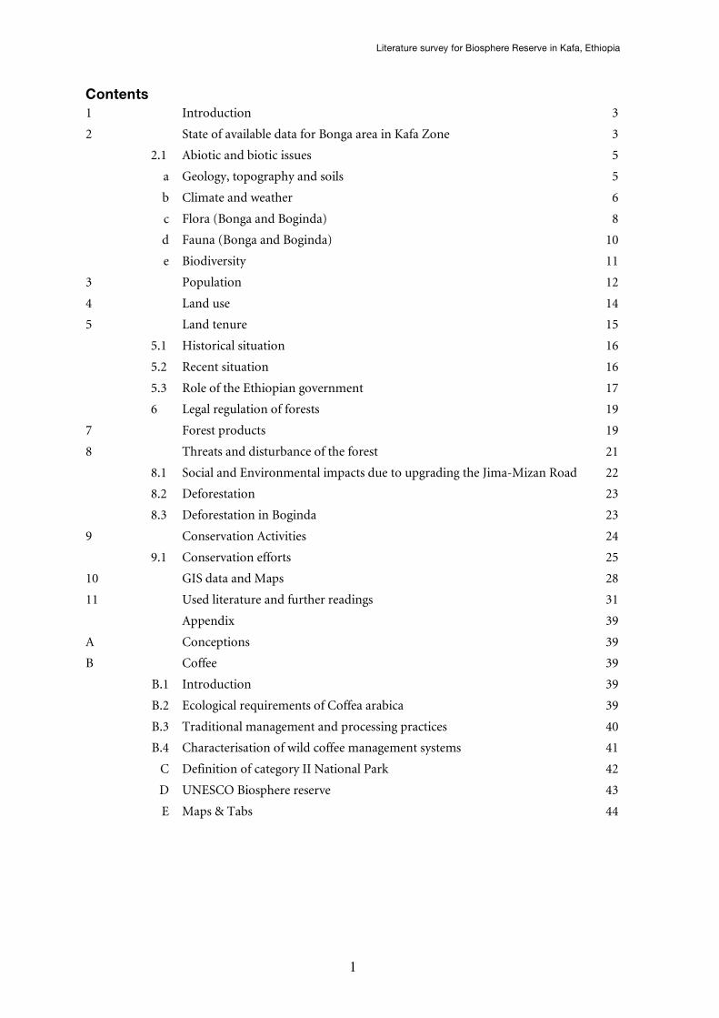
Fig 1: Centre of Boginda Village
In both villages there is no access to electricity and no running
water. Also there is no junior or secondary school, health post,
no police station or any shop. The core of both villages is
located between the church, primary school and a little
marketplace. The tukuls (swahili word for huts) are punctually
situated within the ecosystem. The economy is based on
subsistence and agrarian production. The main agricultural
produces are teff and maize. Coffee is the only cash crop.
Besides them there is main staple food kocho (made of enset
plant). The residents are mainly dependent on the fuelwood, building material and wild
coffee (Philippe, L., 2003).
Source: Philippe, L., 2003
Mankira is located within the Decha wereda. There do exist about 170 households.
Mankira village is closer to Bonga than Boginda but more difficult to reach. The only
possibility to transport things is by horse and mules. For detailed illustration on location
and coffee management system of study plots in Mankira forest see Map 9 in the
appendix.
2.1) Abiotic and biotic issues
In the following chapter the abiotic and biotic issues information about the abiotic and
biotic issues are summarised.
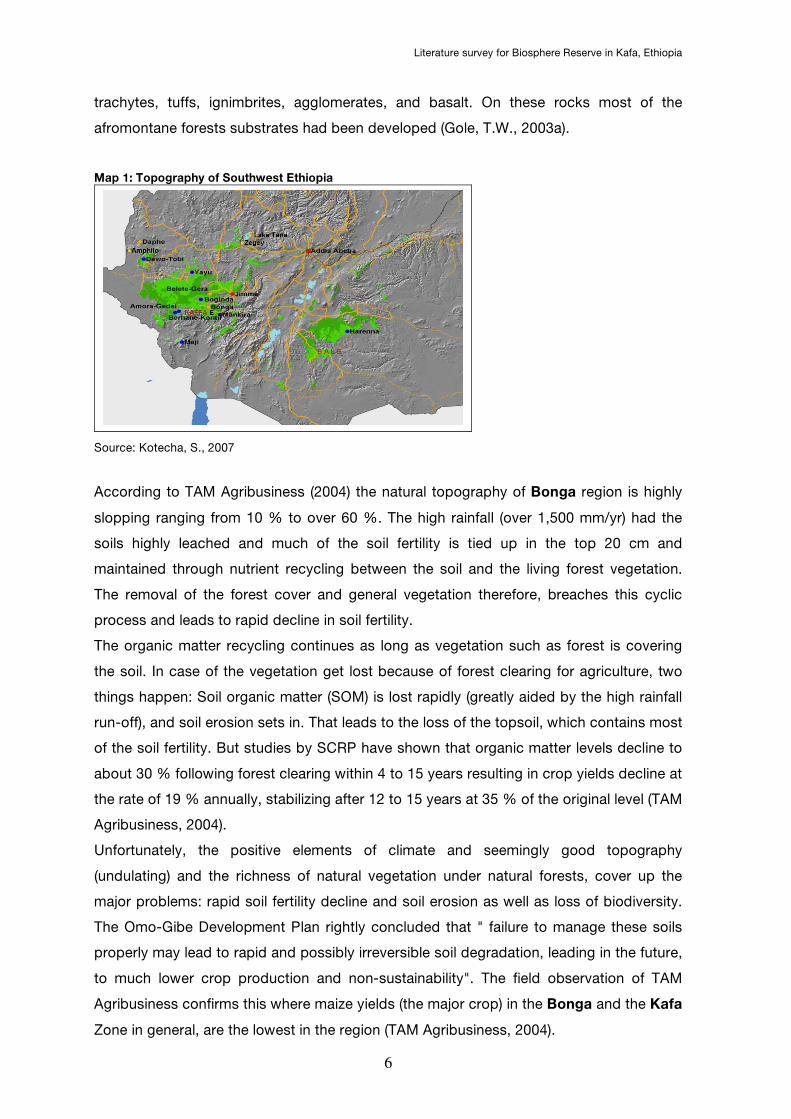
a) Geology, topography and soils
According to Taestensen, F. et al. (2007) Ethiopia is located within two significant
Biodiversity Hotspots, the Horn of Africa and the Eastern Afromontane. The Eastern
Afromontane contains the mesic highland plateaux, which has major endemism due to
isolation of the surrounding landscapes. The Southwestern Ethiopian montane rainforests
are the centre of origin and diversity for wild Coffee Arabica. "The underlaying basement
rock consists intensively folded and faulted Precambrian rocks, layered by mesozoic
marine strata and tertiary basalt traps. The tertiary volcanic rocks include rhyolites,
Literature survey for Biosphere Reserve in Kafa, Ethiopia
6
trachytes, tuffs, ignimbrites, agglomerates, and basalt. On these rocks most of the
afromontane forests substrates had been developed (Gole, T.W., 2003a).
Map 1: Topography of Southwest Ethiopia
Source: Kotecha, S., 2007
According to TAM Agribusiness (2004) the natural topography of Bonga region is highly
slopping ranging from 10 % to over 60 %. The high rainfall (over 1,500 mm/yr) had the
soils highly leached and much of the soil fertility is tied up in the top 20 cm and
maintained through nutrient recycling between the soil and the living forest vegetation.
The removal of the forest cover and general vegetation therefore, breaches this cyclic
process and leads to rapid decline in soil fertility.
The organic matter recycling continues as long as vegetation such as forest is covering
the soil. In case of the vegetation get lost because of forest clearing for agriculture, two
things happen: Soil organic matter (SOM) is lost rapidly (greatly aided by the high rainfall
run-off), and soil erosion sets in. That leads to the loss of the topsoil, which contains most
of the soil fertility. But studies by SCRP have shown that organic matter levels decline to
about 30 % following forest clearing within 4 to 15 years resulting in crop yields decline at
the rate of 19 % annually, stabilizing after 12 to 15 years at 35 % of the original level (TAM
Agribusiness, 2004).
Unfortunately, the positive elements of climate and seemingly good topography
(undulating) and the richness of natural vegetation under natural forests, cover up the
major problems: rapid soil fertility decline and soil erosion as well as loss of biodiversity.
The Omo-Gibe Development Plan rightly concluded that " failure to manage these soils
properly may lead to rapid and possibly irreversible soil degradation, leading in the future,
to much lower crop production and non-sustainability". The field observation of TAM
Agribusiness confirms this where maize yields (the major crop) in the Bonga and the Kafa
Zone in general, are the lowest in the region (TAM Agribusiness, 2004).

Literature survey for Biosphere Reserve in Kafa, Ethiopia
7
But the farmers keep on clearing more land and bring under cultivation. Their aim is to
establish more secure land tenure on the evidence of increasing trend of settlements and
allocation of large tracts of lands to commercial concerns (TAM Agribusiness, 2004).
According to Gole, T. W., (2003a), the soils (red or brownish ferrisols) are derived from
volcanic parent material. The spreading of high rainfall has hided other soil forming-
factors and hence, very similar soils have developed on a repertory of parent materials.
Other soil groups in the area are nitosols, acrisols, vertisols, and cambisols (Gole, T.W.,
2003a).
According to Schmitt, Ch. B. (2006) the rich in humus makes the soils of Bonga ideal for
coffee growing, they are well drained, and have good water-holding capacity. Moreover
the Ethiopian coffee forest soils are similar to the best soils on which Arabica coffee is
cultivated in other parts of the world. The soils are characterized as deep red to brown
red, lateritic loams or clay loams of volcanic origin with high or medium fertility, and with
pH values ranging from 5.3 to 6.6. “The pH values of soils in Bonga region are at the
lower end of this range. This corresponds to the fact, that coffee favours slightly acid soils
in Ethiopia [...], and grows well on soils with pH between 4.37 and 6.78 [...]" (Schmitt, Ch.
B., 2006). For detailed data on differences in soil parameters between four forest
fragments icluding Mankira forest see Tab 17 in the appendix.
The Bonga region is characterised by poverty and landlessness. The area under forest in
the Kefficho-Sheka zone is only 29 % while area under cultivation is 55.9 %. Considering
to the cereal agriculture expansion, soil-conservation becomes important (TAM
Agribusiness, 2004).
b) Climate and Weather
The Inter-Tropical Convergence Zone (ITCZ) signs the Ethiopian climate. The weather
determinating factors are the humid Southwest monsoon and the dry Northeast trade
winds. Summarised there are four seasons: dry season (December – February), small
rainy season (March - May), main rainy season (June - August), and transitional period
(September – December). Intensities and frequencies of rainfall in the entire Ethiopia
depending on altitude and exposure of the area (Schmitt, Ch. B., 2006), so it is difficult to
give clear information on a determined area.
In Boginda there does not exist a meteorological station so the data from Bonga station
has to be used, which has almost the same altitudinal range as Boginda forest. (IBCR &
GTZ, s.a.) Bonga region is humid and has warm tropical rainy climate [...]. The rainfall is
uni-modal with low rainfall from November to February and the wettest months between
May and September. The coolest months are July and August in the middle of the main
rainy season, while the hottest months are from February to May.
Literature survey for Biosphere Reserve in Kafa, Ethiopia
8
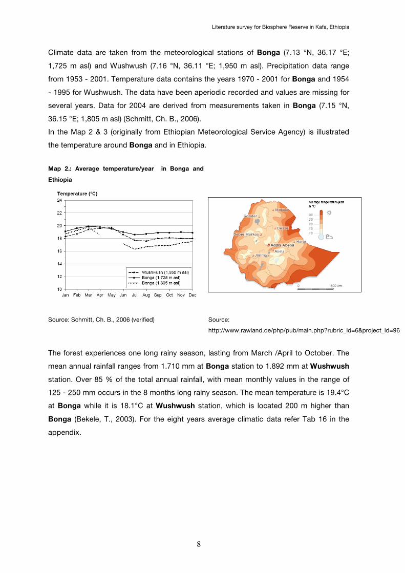
Climate data are taken from the meteorological stations of Bonga (7.13 °N, 36.17 °E;
1,725 m asl) and Wushwush (7.16 °N, 36.11 °E; 1,950 m asl). Precipitation data range
from 1953 - 2001. Temperature data contains the years 1970 - 2001 for Bonga and 1954
- 1995 for Wushwush. The data have been aperiodic recorded and values are missing for
several years. Data for 2004 are derived from measurements taken in Bonga (7.15 °N,
36.15 °E; 1,805 m asl) (Schmitt, Ch. B., 2006).
In the Map 2 & 3 (originally from Ethiopian Meteorological Service Agency) is illustrated
the temperature around Bonga and in Ethiopia.
Map 2.: Average temperature/year in Bonga and
Ethiopia
Source: Schmitt, Ch. B., 2006 (verified) Source:
http://www.rawland.de/php/pub/main.php?rubric_id=6&project_id=96
The forest experiences one long rainy season, lasting from March /April to October. The
mean annual rainfall ranges from 1.710 mm at Bonga station to 1.892 mm at Wushwush
station. Over 85 % of the total annual rainfall, with mean monthly values in the range of
125 - 250 mm occurs in the 8 months long rainy season. The mean temperature is 19.4°C
at Bonga while it is 18.1°C at Wushwush station, which is located 200 m higher than
Bonga (Bekele, T., 2003). For the eight years average climatic data refer Tab 16 in the
appendix.
Literature survey for Biosphere Reserve in Kafa, Ethiopia
9
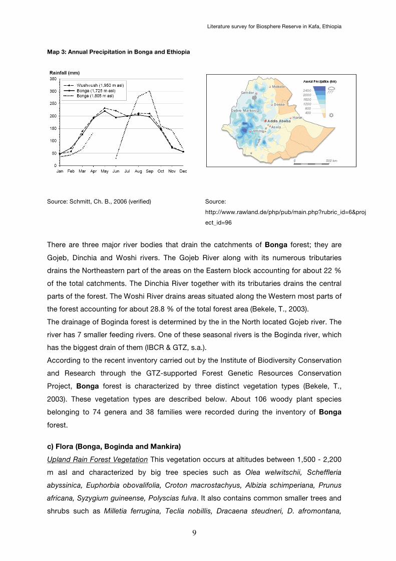
Map 3: Annual Precipitation in Bonga and Ethiopia
Source: Schmitt, Ch. B., 2006 (verified) Source:
http://www.rawland.de/php/pub/main.php?rubric_id=6&proj
ect_id=96
There are three major river bodies that drain the catchments of Bonga forest; they are
Gojeb, Dinchia and Woshi rivers. The Gojeb River along with its numerous tributaries
drains the Northeastern part of the areas on the Eastern block accounting for about 22 %
of the total catchments. The Dinchia River together with its tributaries drains the central
parts of the forest. The Woshi River drains areas situated along the Western most parts of
the forest accounting for about 28.8 % of the total forest area (Bekele, T., 2003).
The drainage of Boginda forest is determined by the in the North located Gojeb river. The
river has 7 smaller feeding rivers. One of these seasonal rivers is the Boginda river, which
has the biggest drain of them (IBCR & GTZ, s.a.).
According to the recent inventory carried out by the Institute of Biodiversity Conservation
and Research through the GTZ-supported Forest Genetic Resources Conservation
Project, Bonga forest is characterized by three distinct vegetation types (Bekele, T.,
2003). These vegetation types are described below. About 106 woody plant species
belonging to 74 genera and 38 families were recorded during the inventory of Bonga
forest.
c) Flora (Bonga, Boginda and Mankira)
Upland Rain Forest Vegetation This vegetation occurs at altitudes between 1,500 - 2,200
m asl and characterized by big tree species such as Olea welwitschii, Scheffleria
abyssinica, Euphorbia obovalifolia, Croton macrostachyus, Albizia schimperiana, Prunus
africana, Syzygium guineense, Polyscias fulva. It also contains common smaller trees and
shrubs such as Milletia ferrugina, Teclia nobillis, Dracaena steudneri, D. afromontana,
Literature survey for Biosphere Reserve in Kafa, Ethiopia
10
Galiniera saxifraga and Coffea arabica. Ground herbs include false Cardamom
(Afromomum corrorima).
Upland Humid Forest Vegetation This vegetation occurs at altitudes between 2,450 -
2,800 m asl. and characterised by tree and shrub species such as Hagenia abyssinica,
Ilex mitis, Myrsine melanophloeos (Rapaenia simensis), Maesa lanseolata and Barsama
abyssinica.
Sinarindunaria /Bamboo Thicket This vegetation occurs at altitudes between 2,400 - 3,050
m asl and characterized by bamboo undergrowth either in pure stands or may exist in
mixture with trees, including H. abyssinica, M. melanophloeos, and Hypericum revolutum
(Bekele, T., 2003).
The areas in and around Bonga forest are inhabited by a minimum of 48 mammalian
species, representing fourteen families and 100 bird species were recorded from the area.
Fifteen of the bird species are reported to comprise the “Highland Biome Species”, thus
accounting for 31 % of the Restricted Highland Biome Assemblages in Ethiopia” (Bekele,
T., 2003).
According to BirdLife IBA, 2007, the tallest trees are Aningeria adolfi-friderici. Besides
them there are growing Ocotea kenyensis, Olea capensis, Sapium ellipticum, Macaranga
capensis, several species of Albizia, Euphorbia ampliphylla, Polyscias fulva, Schefflera
abyssinica and several different Ficus spp. The rich understorey is including the tree-fern
Cyathea manniana found in moist ravines and near waterfalls, Dracaena steudneri and
Coffea arabica. "The higher parts of the forest support smaller trees such as Hagenia
abyssinica and Prunus africana. Bonga forest has long been exploited for its large timber
species and this is continuing. Some areas have been left to regenerate naturally, but over
2,000 ha have been planted with exotic and native species such as Eucalyptus, Hagenia
abyssinica, Cordia africana, Cuppressus, Grevillea and Pinus patula. Local people make
extensive use of the forest and many non-timber forest products are collected,
particularly coffee and honey" (BirdLife IBA, 2007).
In Bonga forest had been 106 woody plants recorded. 94 of them are identified to
species level. 5 are identified to a Genus level and 8 are unidentified. The major Genera
are:
Combretum, Erythrina, Euphorbia, Myrsine, Rubus, Schefflera, Solanecio, Teclea, Vepris,
Acacia, Dracaena, Ficus, Maytenus and Vernonia.
The major families are: Bignoniaceac.e, Combretaceae, Fabaceae, Moraceae,
Myrsinaceae, Rubiaceae, Rutaceae, and Sapindaceae
The predominant species are: Ocotea kenyensis, Prunus africana, Syzygium guineense,
Pouteria adolfi – friederici, Olea capensis, Ekebergia capensis, Ficus vasta, Syzygium
Literature survey for Biosphere Reserve in Kafa, Ethiopia
11
guineense, Prunus africana, Albizia gummifera, Schefflera abyssinica, Ficus sur and
Schefflera volkensii.
In Boginda forest had been 73 woody plants recorded. 66 of them are identified to
species level. 4 are identified to a Genus level and 3 are unidentified. The major Genera
are: Albizia, Euphorbia, Ficus, Maytenus, Schefflera, Tiliachora and Vernonia.
The major families are:
Rubiaceae, Euphorbiaceae, Celasteraceae, and Fabaceae.
The predominant species are:
Pouteria adolfi – friederci, Bersama abyssinica, Schefflera abyssinica, Trilepsium
madagascariense, Polyscias fulva and Coffea arabica (IBCR & GTZ, s.a.).
There is only one emergent species from the 20 - 30 m high canopy, namely Pouteria
adolfi-freidrci. The 10 - 30 m high main canopy consists of Albizia gummifera, A.
schimperiana, A. grandibracteata, Blighia unijugata, Cassipourea mlosana, Celtis africana,
Croton macrostachyus, Ekebergia capensis, Euphorbia ampliphylla, Ficus sur, F. ovata, F.
thoningii, Hallea rubrostipulta, Ilex mitis, Macaranga capensis, Ocotea kenyensis, Olea
welwitschii, Polyscias fulva, Scefflera abyssinica, Prunus africana, Sapium ellipticum, and
Syzygiun guineense. A discontinuous lower canopy of smaller trees (< 10m high) includes
Allophylus abyssinicus, Apodytes dimidiata, Bersama abyssinca, Brucea antidysentrica,
Calpurnea aurea, Cathium oligocarpum, Chionanthus mildbraedii, Clausena anisata,
Coffea arabica, Cyathea manniana, Deinbollia kilimandscharica, Dracaena afromontana, D.
fragrans, D. steudneri, Ehretia abyssinica, Erythrina brucei, Galinera saxifraga,
Lepidotrichlia volkensii, Lobelia gibrroa, Milletia ferruginea, Nuxia congesta, Oncoba
routledgei, Oxyathus speciosus subsp. stenocarpus, Phoenix reclinata, Pittosporum
viridiflorum, Psychotoria orophila, Ritchiea albersii, Rothmannia urcelliformis, Solanecio
gigas, Solanecio manni, Teclea nobilis, Trema orientalis, Turrea holitii, and vepris dainellii
(IBCR & GTZ, s.a.).
The shrub stratum includes Acanthus eminens, Maytenus addatp., Phyllanthus limuensis
and whitfieldia elongata. Hippocratea goetzei and Landolphia buchanani are the most
frequent liana species that exist in this forest.The ground cover is dominated by grasses
and certain thorny species such as Acacia lahai, Acanthus spp., Dichrostachyus cinerea
and Solanum spp (IBCR & GTZ, s.a.).
More floristical information such as regeneration of Boginda forest is listed in GTZ, for
more information about plants and their distribution within Mankira see the Appendix of
Schmitt, Ch.B., 2006.
d) Fauna (Bonga, Boginda and Mankira)
The Bonga Forest contains more than 15 species of highland birds (Biology Online, s.a.).

Literature survey for Biosphere Reserve in Kafa, Ethiopia
12
During forest avifauna survey in December 1995 more than 100 species were recorded.
In the following they are listed. Black-winged Lovebird (Agapornis taranta), White-cheeked
Turaco (Tauraco leucotis), Banded Barbet (Lybius undatus), Dark-headed Oriole (Oriolus
monacha), Thick-billed Raven (Corvus crassirostris), White-backed Tit (Parus leuconotus),
Stuhlmann's Starling (Poeoptera stuhlmanni), Abyssinian Ground-thrush (Zoothera
piaggiae), Rueppell's Robin-chat (Cossypha semirufa), Abyssinian Slaty Flycatcher
(Dioptrornis chocolatinus), Swainson's Sparrow (Passer swainsonii), Baglafecht Weaver
(Ploceus baglafecht), Abyssinian Citril (Serinus citrinelloides), Brown-rumped Seedeater
(Serinus tristriatus) and Streaky Seedeater (Serinus striolatus). Further information about
the avifauna gives BirdLife IBA (2007).
During a BirdLife survey the team found Colobus and Vervet Monkeys as well as Tree
Squirrel. Information of locals are telling about the presence of Lion, Leopard, Buffalo,
Elephant, Porcupine, Aardvark, Wart Hog and Forest Pig. Moreover the people of the tribe
of the Mandjah are eating Colobus guereza what plays a significant role in the
exclusionary relationship between Kaffa and Mandjah (Stellmacher, T., 2006).
In and around Bonga forest there are at least 48 mammalian species, representing
fourteen families and 100 bird species. Fifteen of the bird species are reported to
comprise the “Highland Biome Species”, thus accounting for 31 % of the Restricted
Highland Biome Assemblages in Ethiopia (Bekele, T., 2003).
High-altitude forest is severely endangered in Ethiopia. "Although Bonga forest is
designated a National Forest Priority Area, little has been done to enforce the existing
legislation. The current forest extent is unknown, but it has decreased since the 1970s.
The forest is next to two major roads, making the removal of timber relatively easy. The
more accessible parts of the forest are highly disturbed and now comprise thick
undercover that could certainly be a hindrance to the larger mammals reported to occur.
The fact that any forest remains is almost certainly due to the broken terrain within the
Dincha watershed. Major threats include the introduction of exotic tree plantations,
clearance for agriculture, and some grazing. The effect of grazing is currently not serious,
but could become so, severely affecting the potential for forest regeneration. The forest
coffee, Coffea arabica, of Bonga is genetically important, as it was from this area, near
Wushwush, that the first plants with natural resistance to coffee berry disease were
identified. Tree-ferns Cyathea manniana are known from only a few locations in Ethiopia;
they require well-shaded and moist conditions to grow and would disappear if the forest
was destroyed" (BirdLife IBA, 2007). Forest hogs are living 30 km around Jima we.There
are also some of them in the Kafa Mountains. A list of List of species recorded in Bonga
region gives the appendix Table A 1 of Schmitt, Ch. B., 2006.
Literature survey for Biosphere Reserve in Kafa, Ethiopia
13
According to to the reports of Consulting for Coffee Conservation written in IBCR & GTZ,
s.a. there is following wildlife in and around Boginda:
Vivera civeta (“Tirign”), Silvicapra grimmia (“Midaqua”), Papio anubis daguera (“Zinjero”),
Syncerus caffer (“Gosh”), Traglaphus scriptus (“Dekula”), Patomochoerus porcus
(“Asama”), Cercopithecus mitis (“Cheno”), Colobus guereza (“gureza”), Genetta rubiginosa
(“Genet”), Viverrdae sanguineus (“Shelmitmat”), Ethiopian hare (“tenchel”), Jakal
(“Kebero”), Hyaena hyaena (“Jib”), Felis pardus (“Nebir”), Felis leo (“ambessa”), Hystrix
cristata (“Jart”), Rock python (“Zendo”), Snakes (black, red and stripped), Phacochoerus
africanus (“Kerkero”), “Worebo” and Caris simensis (“Tekula”).
Bird species which were found in or arround Boginda Forest are: Bostrichia caruculata
(Watttled Ibis), Cyanochen cyanoptera (blue winged goose), Poicephalus flavifronse
(Yellow fronted parrot), Parophasma galinieri (Abyssinian cat bird), Parus leuconutus
(White backed black tit), Onchoganthus albirotris (White billed starling), Oriolus
monanacha (Black headed forest oriole) and Caruvus crassirostris (thick billed raven).
Information about the layer species and epiphytes, ground layer species, woody species
and climbers of Mankira is given in appendix Table A 3 and Table A 4 of Schmitt, Ch. B.
(2006). Information on conservation status of major mammals and birds in Ethiopia gives
Tab 18 in the appendix. Information about reptiles and amphibians are not available.
e) Biodiversity
The Southwestern part of Ethiopia is known as the genetic home of coffee. During a study
between 1966 and 1984 more than 600 coffee species were found by the Ethiopian
National Coffee Collection Programme. Now, 20 years later more coffee species have
been found but not really documented (Stellmacher, T., 2006). The chapters 2c and 2d
show the large scale of biodiversity.
3) Population
The SNNPR has about 15,000,000 inhabitants. The density of SNNPR has a maximum of
680 persons/km² (Soil and Water Conservation Team, 2001).
The SNNPR is the most ethnically and lingually various administrative region in Ethiopia.
The Kafa people are the indigenous inhabitants of Bonga region who are speaking
omotic language. In the past, the Kafa society has been earmarked by a highly inflexible
and complex class-system, based on occupation, descent and status. The Mandjah
people form for 5 to 10 % of the total population. They are the largest minority society
that still faces prejudices and discrimination today. With a maximum in the mid-80ies,
there was a governmentally introduced and spontaneous resettlement of peoples from
Literature survey for Biosphere Reserve in Kafa, Ethiopia
14
North and central to Southwest Ethiopia. In Bonga region, Amhara, Oromo and Gawata
became the largest groups of new settlers. Bonga town is the administrative centre of
Kafa zone and the major town in the area with 16,278 inhabitants (CSA, 2007). Ufa (1,000
inhabitants) and Chiri (1,655 inhabitants) are the administrative centres of Gimbo and
Decha wereda, respectively. Most of the people are living in hamlets or small villages in
the countryside. The average population densities of Gimbo and Decha wereda are 103
and 33 inhabitants/km², respectively (Schmitt, Ch. B., 2006).
Gimbo wereda has a high population rate. 45 % of the population of the Gimbo wereda
are younger than 15 years (TAM Agribusiness, 2004).
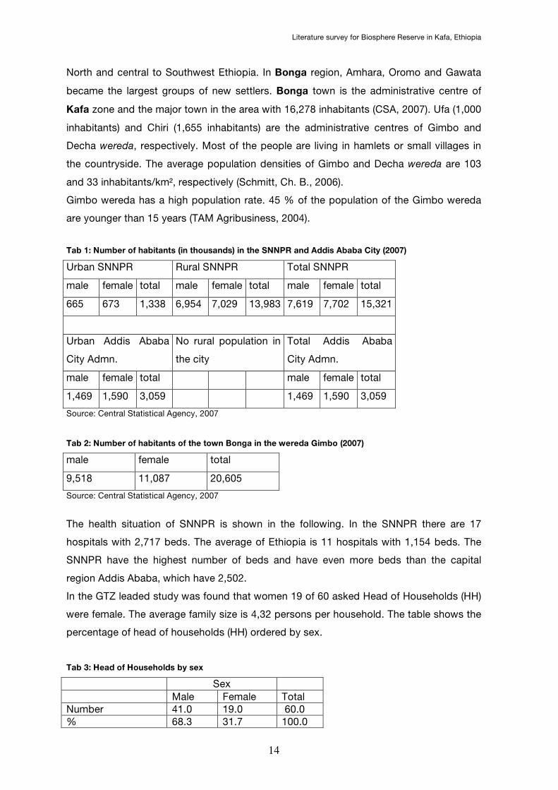
Tab 1: Number of habitants (in thousands) in the SNNPR and Addis Ababa City (2007)
Urban SNNPR Rural SNNPR Total SNNPR
male female total male female total male female total
665 673 1,338 6,954 7,029 13,983 7,619 7,702 15,321
Urban Addis Ababa
City Admn.
No rural population in
the city
Total Addis Ababa
City Admn.
male female total male female total
1,469 1,590 3,059 1,469 1,590 3,059
Source: Central Statistical Agency, 2007
Tab 2: Number of habitants of the town Bonga in the wereda Gimbo (2007)
male female total
9,518 11,087 20,605
Source: Central Statistical Agency, 2007
The health situation of SNNPR is shown in the following. In the SNNPR there are 17
hospitals with 2,717 beds. The average of Ethiopia is 11 hospitals with 1,154 beds. The
SNNPR have the highest number of beds and have even more beds than the capital
region Addis Ababa, which have 2,502.
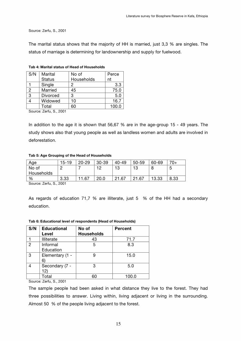
In the GTZ leaded study was found that women 19 of 60 asked Head of Households (HH)
were female. The average family size is 4,32 persons per household. The table shows the
percentage of head of households (HH) ordered by sex.
Tab 3: Head of Households by sex
Sex
Male Female Total Number 41.0 19.0 60.0 % 68.3 31.7 100.0
Literature survey for Biosphere Reserve in Kafa, Ethiopia
15
Source: Zerfu, S., 2001
The marital status shows that the majority of HH is married, just 3,3 % are singles. The
status of marriage is determining for landownership and supply for fuelwood.
Tab 4: Marital status of Head of Households
S/N Marital Status
No of Households
Percent
1 Single 2 3.3 2 Married 45 75.0 3 Divorced 3 5.0 4 Widowed 10 16.7 Total 60 100.0 Source: Zerfu, S., 2001
In addition to the age it is shown that 56,67 % are in the age-group 15 - 49 years. The
study shows also that young people as well as landless women and adults are involved in
deforestation.
Tab 5: Age Grouping of the Head of Households
Age 15-19 20-29 30-39 40-49 50-59 60-69 70+ No of Households
2 7 12 13 13 8 5
% 3.33 11.67 20.0 21.67 21.67 13.33 8.33 Source: Zerfu, S., 2001
As regards of education 71,7 % are illiterate, just 5 % of the HH had a secondary
education.
Tab 6: Educational level of respondents (Head of Households)
S/N Educational
Level
No of
Households
Percent
1 Illiterate 43 71.7 2 Informal
Education 5 8.3
3 Elementary (1 - 6)
9 15.0
4 Secondary (7 - 12)
3 5.0
Total 60 100.0 Source: Zerfu, S., 2001
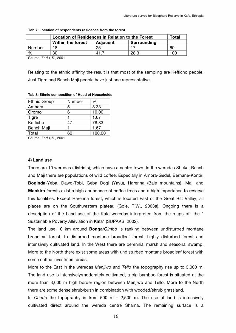
The sample people had been asked in what distance they live to the forest. They had
three possibilities to answer. Living within, living adjacent or living in the surrounding.
Almost 50 % of the people living adjacent to the forest.
Literature survey for Biosphere Reserve in Kafa, Ethiopia
16
Tab 7: Location of respondents residence from the forest
Location of Residences in Relation to the Forest Total
Within the forest Adjacent Surrounding
Number 18 25 17 60 % 30 41.7 28.3 100 Source: Zerfu, S., 2001
Relating to the ethnic affinity the result is that most of the sampling are Kefficho people.
Just Tigre and Bench Maji people have just one representative.
Tab 8: Ethnic composition of Head of Households
Ethnic Group Number % Amhara 5 8.33 Oromo 6 10.00 Tigre 1 1.67 Kefficho 47 78.33 Bench Maji 1 1.67 Total 60 100.00 Source: Zerfu, S., 2001
4) Land use
There are 10 weredas (districts), which have a centre town. In the weredas Sheka, Bench
and Maji there are populations of wild coffee. Especially in Amora-Gedel, Berhane-Kontir,
Boginda-Yeba, Dawo-Tobi, Geba Dogi (Yayu), Harenna (Bale mountains), Maji and
Mankira forests exist a high abundance of coffee trees and a high importance to reserve
this localities. Except Harenna forest, which is located East of the Great Rift Valley, all
places are on the Southwestern plateau (Gole, T.W., 2003a). Ongoing there is a
description of the Land use of the Kafa weredas interpreted from the maps of the "
Sustainable Poverty Alleviation in Kafa" (SUPAKS, 2002).
The land use 10 km around Bonga/Gimbo is ranking between undisturbed montane
broadleaf forest, to disturbed montane broadleaf forest, highly disturbed forest and
intensively cultivated land. In the West there are perennial marsh and seasonal swamp.
More to the North there exist some areas with undisturbed montane broadleaf forest with
some coffee investment areas.
More to the East in the weredas Menjiwo and Tello the topography rise up to 3,000 m.
The land use is intensively/moderately cultivated, a big bamboo forest is situated at the
more than 3,000 m high border region between Menjiwo and Tello. More to the North
there are some dense shrub/bush in combination with wooded/shrub grassland.
In Chetta the topography is from 500 m – 2,500 m. The use of land is intensively
cultivated direct around the wereda centre Shama. The remaining surface is a
Literature survey for Biosphere Reserve in Kafa, Ethiopia
17
combination of montane broadleaf forest undisturbed/disturbed/highly disturbed. There is
also some lowland forest disturbed/undisturbed. In the South of Chetta Savannah shrub-
/grassland is dominating.
The most South wereda Decha with Chiri as the centre town has oblong propagation of
about 60 km and reach nearly to Bonga. The South of Decha is marked by land high
between less than 500 m - 1,000 m, partly 2,000 m. The land use of the South is very
homogeneous. Just savannah shrub-/grassland with particularly dense shrub-/grassland
disturbed lowland forest and disturbed montane broadleaf forest are existing.
In the middle West in Chena the landscape ranges from 1,000 m to particularly 2,500 m.
In the South of Chena intensively cultivation is dominating with exception of the Eastern
part where disturbed/undisturbed montane broadleaf forest is located. Also a few parts
with dense shrub and open grassland are available. The Northern part of Chena is marked
of a mix of undisturbed montane broadleaf forest, perennial marsh and intensively
cultivation.
The Western wereda Bita ranges also from 1,000 m up to 2,500 m, particularly up to
3,000 m. In the Southwestern part of Bita there is a 25 km * 12 km big area of undisturbed
montane broadleaf forest. Just at the edge there is intensively cultivated and highly
disturbed forest. More to North the land use is differently. Seasonal swamp, perennial
marsh and bamboo forest are existing in the Northwestern area. The Northeastern part
shows undisturbed montane broadleaf forest with punctually cultivated land and
disturbed/high disturbed montane broadleaf forest. At the borderline to Gimbo there are
some coffee investment areas.
More to North the wereda Gesha with a high from 1,500 m to partly 3,000 m is located.
The land is moderately/intensively cultivated. Around the centre town Daka exists
perennial marsh cultivated land. Just in Northwest of Gesha there is an area of around 10
km * 20 km with undisturbed montane broadleaf forest.
The most Northern wereda Saylem ranges between 1,500 m till 3,000 m, but the most is
about 1,500 m to 2,000 m. The vegetation is in general parted in to the Western almost
undisturbed montane broadleaf forest and in to the Eastern part with intensively cultivated
and bamboo forest.
In the last wereda Gawata neighbouring with Gimbo the land is 1,500 m to 2,000 m high.
The land is covered by a proportionally big area undisturbed montane broadleaf forest (30
km * 10 km). Small areas with perennial marsh and seasonal swamp are located in the
South and North. A few coffee investment areas are also located in the North of Gawata.
5) Land tenure

Literature survey for Biosphere Reserve in Kafa, Ethiopia
18
In advance there is a graphic that shows the land tenure and land distribution during the
three regimes in Mankira and Boginda. The graphic is taken from Philippe, L. (2003) who
has detailed information about the historical pathway of land use and landtenure.
Fig 2: Land tenure and land distribution during the three regimes
Source: Philippe, L., 2003
5.1) Historical situation
Before 1974 in Kafa was a feudal landlord system established, which regulated the
management and the property rights. The landlords who gave use rights to the peasants
ruled most of the forest. To use the land they had to pay a fee in form of e.g. honey. The
use of the forest and the cultivation of coffee were traditional determined in local
institutional systems (Stellmacher, T., 2005).
After the revolution in 1974 the new military government known as derg regime
empowered the landlords and everything came under direct possession of the state. This
had many negative impacts on the relationship between state and local communities
(Stellmacher, T., 2005).
In the 1980ies there was governmental ressetlement-programme. Between 1985 and
1988 about 50.000 households (~ 250.000 persons) were brought from drought-stricken
regions of Ethiopia to Kafa because of the better fertile situation of the region. From this
resulted a change in ethnic and institutional composition in that area. More the pressure
of nutrition became higher on Kafa forest (Stellmacher, T., 2005). Further information give
Philippe, L., 2003 and Reusing, M., 2000
Literature survey for Biosphere Reserve in Kafa, Ethiopia
19
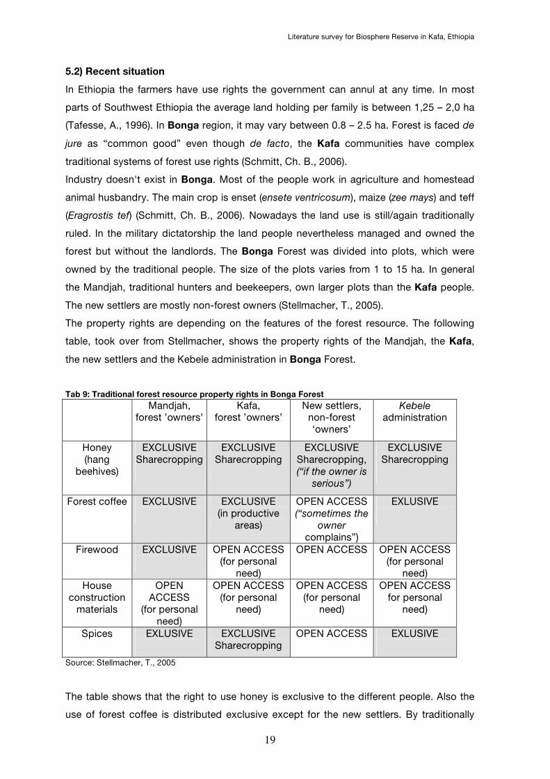
5.2) Recent situation
In Ethiopia the farmers have use rights the government can annul at any time. In most
parts of Southwest Ethiopia the average land holding per family is between 1,25 – 2,0 ha
(Tafesse, A., 1996). In Bonga region, it may vary between 0.8 – 2.5 ha. Forest is faced de
jure as “common good” even though de facto, the Kafa communities have complex
traditional systems of forest use rights (Schmitt, Ch. B., 2006).
Industry doesn't exist in Bonga. Most of the people work in agriculture and homestead
animal husbandry. The main crop is enset (ensete ventricosum), maize (zee mays) and teff
(Eragrostis tef) (Schmitt, Ch. B., 2006). Nowadays the land use is still/again traditionally
ruled. In the military dictatorship the land people nevertheless managed and owned the
forest but without the landlords. The Bonga Forest was divided into plots, which were
owned by the traditional people. The size of the plots varies from 1 to 15 ha. In general
the Mandjah, traditional hunters and beekeepers, own larger plots than the Kafa people.
The new settlers are mostly non-forest owners (Stellmacher, T., 2005).
The property rights are depending on the features of the forest resource. The following
table, took over from Stellmacher, shows the property rights of the Mandjah, the Kafa,
the new settlers and the Kebele administration in Bonga Forest.
Tab 9: Traditional forest resource property rights in Bonga Forest
Mandjah, forest ’owners’
Kafa, forest ’owners’
New settlers, non-forest ‘owners’
Kebele administration
Honey (hang
beehives)
EXCLUSIVE Sharecropping
EXCLUSIVE Sharecropping
EXCLUSIVE Sharecropping, (“if the owner is
serious”)
EXCLUSIVE Sharecropping
Forest coffee
EXCLUSIVE
EXCLUSIVE (in productive
areas)
OPEN ACCESS (“sometimes the
owner complains”)
EXLUSIVE
Firewood
EXCLUSIVE
OPEN ACCESS (for personal
need)
OPEN ACCESS
OPEN ACCESS (for personal
need) House
construction materials
OPEN ACCESS
(for personal need)
OPEN ACCESS (for personal
need)
OPEN ACCESS (for personal
need)
OPEN ACCESS for personal
need)
Spices
EXLUSIVE
EXCLUSIVE Sharecropping
OPEN ACCESS EXLUSIVE
Source: Stellmacher, T., 2005
The table shows that the right to use honey is exclusive to the different people. Also the
use of forest coffee is distributed exclusive except for the new settlers. By traditionally
Literature survey for Biosphere Reserve in Kafa, Ethiopia
20
property right Forest Coffee is individually owned, but de facto an open access resource.
The more valuable a product is, the more limited is its open access character
(Stellmacher, T., 2005).
In addition to it there are two informal mechanism which rule the access to the forest in
Kafa region namely Wejoo and Gogoo. Under Wejoo can be understood a system parents
grant their sons trees when they found a family. This mechanism wants to support and
introduce young people into forest activity (Zewdie, Y., 1998).
The other mechanism, Gogoo, is a sharecropping arrangement for forest goods. Young
people getting an assured access to the forest even without the existence of peasants
association. Gogoo has already helped poor farmers including women to generate cash.
There is an advantage towards the Wejoo what base on a land owning family (Zewdie, Y.,
1998).
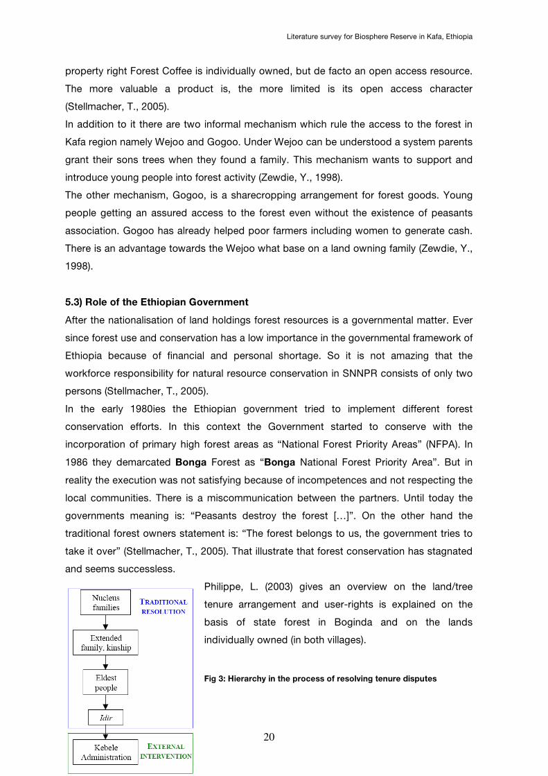
5.3) Role of the Ethiopian Government
After the nationalisation of land holdings forest resources is a governmental matter. Ever
since forest use and conservation has a low importance in the governmental framework of
Ethiopia because of financial and personal shortage. So it is not amazing that the
workforce responsibility for natural resource conservation in SNNPR consists of only two
persons (Stellmacher, T., 2005).
In the early 1980ies the Ethiopian government tried to implement different forest
conservation efforts. In this context the Government started to conserve with the
incorporation of primary high forest areas as “National Forest Priority Areas” (NFPA). In
1986 they demarcated Bonga Forest as “Bonga National Forest Priority Area”. But in
reality the execution was not satisfying because of incompetences and not respecting the
local communities. There is a miscommunication between the partners. Until today the
governments meaning is: “Peasants destroy the forest […]”. On the other hand the
traditional forest owners statement is: “The forest belongs to us, the government tries to
take it over” (Stellmacher, T., 2005). That illustrate that forest conservation has stagnated
and seems successless.
Philippe, L. (2003) gives an overview on the land/tree
tenure arrangement and user-rights is explained on the
basis of state forest in Boginda and on the lands
individually owned (in both villages).
Fig 3: Hierarchy in the process of resolving tenure disputes
Literature survey for Biosphere Reserve in Kafa, Ethiopia
21
The situation in the state forest in Boginda is that customary and statutory laws are
admistrated by the government. The NTFP are in an open access what includes that
nobody has the right to own or inherit the coffee trees. Exceptional people who
used/owned coffee before the transfer to state ownership. The law gives them the
admission to use the coffee (Philippe, L., 2003).
If a person collects coffee without permission of the owner the customary law intends that
this person could get a problem to be part of the Idir (leaders of the traditional social
organisation). In addition to it this persons risks to loose his membership of the
organisation (Philippe, L., 2003).
Source: Philippe, L., 2003
Landowners have the right to own, to use, to dispose of and to inherit the tree and the
right to collect coffee cherries. If a person owns land at the same time he owns the coffee
shrub and has the user rights. This right is guarenteed by the Kebele administration
(Philippe, L., 2003).
Since the middle of the 20th century the land tenure systems changed and the people
adapted their own systems to the actual user right.
More information on user rights and land tenure in Mankira and Boginda is available in
Philippe, L., 2003
6) Legal regulation of forests
In Ethiopia the Proclamation No. 94/1994 manages the forests and the treat with them.
This manifestation gives information on conservation, development and utilization of
forests. It is described shortly for what national issues the "Ministry of Natural Resources
Development and Environmental Protection" is responsible. Issues in the international
context are not described.
In the Proclamation is written that the Ministry "shall designate, demarcate and register
state and protected forests" (PADELIA, s.a.).
"The Ministry [...] may designate any forest at "protected forest" so that any tree species,
bushes and other plants are developed and protected with the object to" (PADELIA, s.a.):
• "protect rare or endangered endemic plant, animal and bird species, and genetic
resources in general"
• "conserve unique and representative habitats or natural resources"

Literature survey for Biosphere Reserve in Kafa, Ethiopia
22
In general the Proclamation No. 94/1994 says that any interventions in the forest has to
sign up by the Ministry of Natural Resources Development and Environmental Protection.
In the paper "annexes to project brief" is a table "The mandates of the concerned
biodiversity conservation and protected area management organizations at a federal
level", which shows the distribution of responsibility of the different institutions. The
Ministry of agriculture and the Prime Minister's Office are the supervisory institutions.
After that the Wildlife Conservation Department, the Forestry, Land use & Conservation
Department, the Institute for Biodiversity Conservation and the Environmental Protection
Authority as the mandates as legally stated
Information on the mandates of the concerned biodiversity conservation and protected
area management organisations at a federal level gives page 44 of the annex of project
brief byGEF (2006). There is explained, which department or office is responsible. The
information status of this annex contains questions and answers to biodiversity and
protected areas in Ethiopia.
7) Forest products
In the Kafa zone there is the so-called "Kafa Forest Coffee Farmers Cooperative Union"
(KFCFCU, s.a.) which let produce coffee, in addition spices, honey and other non-timber
products for local consumption. The union is working to begin exporting cardamom, long
pepper, dried red pepper, and forest honey. The KFCFCU includes 26 coffee-
cooperatives and 4,166 farmers. In the 26 coffee-warehouses they store the harvest of
164,059 ha. (KFCFCU, s.a.)
"Non-timber forest products (NTFPs) such as honey, false cardamom (Afromomum
corrorima) and wild pepper (Piper capense) are important means of income, in particular
for the indigenous Kafa population. Furthermore, the forests are a source for fuel wood,
charcoal, and timber [...]. Coffee collected and managed inside the forest and planted in
home gardens is the most important cash crop [...]. In 2003/04, the Kafa Forest Coffee
Farmers Cooperative Union marketed 131 tons of coffee from forest coffee and semi-
forest coffee systems with Gimbo and Decha wereda contributing 50 % and 30 % [...]"
(Schmitt, Ch. B., 2006).
The long-term average of the annual coffee production ranges from 500 – 900 tons, the
average of honey production is estimated to be 1,318 tons while that of cardamom and
black pepper ranges from 250 – 800 and 150 – 450 tons respectively (Bekele, T., 2003).
The Ethiopian Coffee offers 90 % of Ethiopian export and 80 % of total employment. That
means that coffee production gives employment in the rural areas and livelihood for more
than 15 million people (van der Beek, J. et al., 2006).
Literature survey for Biosphere Reserve in Kafa, Ethiopia
23
Besides coffee spices like korerima and long pepper are the major crops that play a role.
“Korerima, a potential substitute for the Indian cardamom, is endemic to the rainforests of
the Southwest region. Long pepper (Piper capense) can also be a substitute for black
pepper” (van der Beek, J. et al., 2006).
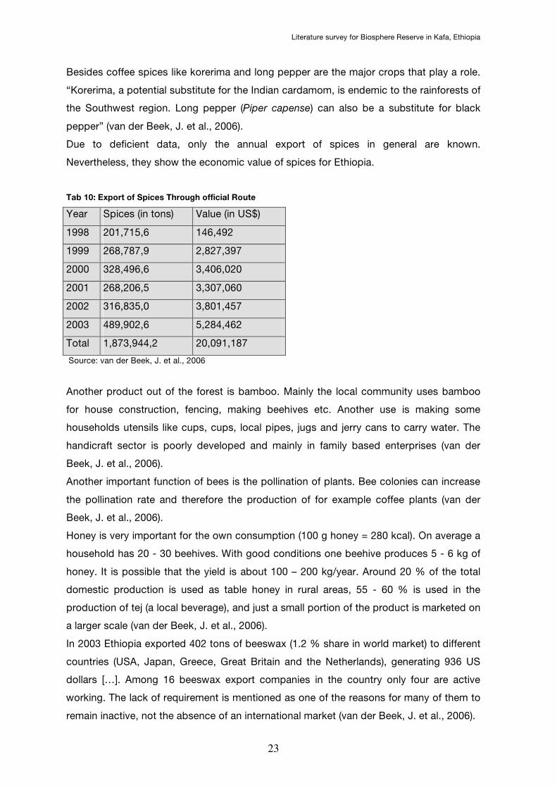
Due to deficient data, only the annual export of spices in general are known.
Nevertheless, they show the economic value of spices for Ethiopia.
Tab 10: Export of Spices Through official Route
Year Spices (in tons) Value (in US$)
1998 201,715,6 146,492
1999 268,787,9 2,827,397
2000 328,496,6 3,406,020
2001 268,206,5 3,307,060
2002 316,835,0 3,801,457
2003 489,902,6 5,284,462
Total 1,873,944,2 20,091,187
Source: van der Beek, J. et al., 2006
Another product out of the forest is bamboo. Mainly the local community uses bamboo
for house construction, fencing, making beehives etc. Another use is making some
households utensils like cups, cups, local pipes, jugs and jerry cans to carry water. The
handicraft sector is poorly developed and mainly in family based enterprises (van der
Beek, J. et al., 2006).
Another important function of bees is the pollination of plants. Bee colonies can increase
the pollination rate and therefore the production of for example coffee plants (van der
Beek, J. et al., 2006).
Honey is very important for the own consumption (100 g honey = 280 kcal). On average a
household has 20 - 30 beehives. With good conditions one beehive produces 5 - 6 kg of
honey. It is possible that the yield is about 100 – 200 kg/year. Around 20 % of the total
domestic production is used as table honey in rural areas, 55 - 60 % is used in the
production of tej (a local beverage), and just a small portion of the product is marketed on
a larger scale (van der Beek, J. et al., 2006).
In 2003 Ethiopia exported 402 tons of beeswax (1.2 % share in world market) to different
countries (USA, Japan, Greece, Great Britain and the Netherlands), generating 936 US
dollars […]. Among 16 beeswax export companies in the country only four are active
working. The lack of requirement is mentioned as one of the reasons for many of them to
remain inactive, not the absence of an international market (van der Beek, J. et al., 2006).
Literature survey for Biosphere Reserve in Kafa, Ethiopia
24
8) Threats and disturbance of the forest
As already mentioned Boginda forest is heavily exploited. The main impacts are logging,
agricultural use and honey production. Honey production affects the existence of trees
because of fire they need during honey production (IBCR & GTZ, s.a.).
During the in 1999 conducted "Woody plant inventory survey", part of Forest Genetic
Resources Conservation Project by the German Technical Cooperation (GTZ) and the
Institute of Biodiversity Conservation and Research (IBCR) 29 quadrates had been
analysed. "7 % were very lightly, 14 % lightly and 3 % moderately disturbed by Logging;
3 % lightly and 3 % moderately disturbed by agricultural encroachment; and 3 % lightly
and 10 % moderately disturbed by honey production. In overall 69 % of the assessed
quadrates were undisturbed and 31 % were disturbed by logging, agricultural
encroachment and honey production" (IBCR & GTZ, s.a.).
Tab 11: Disturbance types and scales of disturbance observed in Boginda forest
Scale of disturbance Percent of
total
Types of
disturbance 1 2 3 4 5
Agricultural
encroachment
1 1* 1* - - 7 %
Honey
production
- 1* 3* - - 14 %
Logging 2* 4* 1 24 %
∗Number of quadrates encountered in each disturbance scale
Source: IBCR & GTZ, s.a.
In addition to it, the coffee exploitation was found to show as very destructive. During the
woody plant inventory survey many stands had been noticed as dry. As a result of illegal
coffee harvest many coffee shrubs had been destroyed in a careless manner (IBCR &
GTZ, s.a.)
The "Conservation and use of wild populations of Coffea arabica in the montane
rainforests of Ethiopia” (CoCE) project carries out on how much wild coffee can actually
be harvested from the forest and what the influences of wild coffee management on the
floristic diversity and structure of the forest are. The fragments contain afromontane forest
with wild coffee in the undergrowth. The number of study plots is according to the size of
forest fragments (Schmitt, Ch. B. et al., 2005). In the following table are the four surveyed
fragments listed.
Literature survey for Biosphere Reserve in Kafa, Ethiopia
25
Tab 12: Studied forest fragments in the Bonga region
Forest
fragment
Total size (ha) Disturbed
forest (in %)
Altitude
(in m asl)
Distance
from Bonga
Number of
study plots
Koma 2,100 25 1,800 - 2,300 20 km NWW 34
Meligawa 500 60 1,700 - 1,950 4 km NE 12
Mankira 900 70 1,550 - 1,800 10 km SO 17
Kayakela 1,200 70 1,600 - 1,750 7 km N 22
Source: Schmitt, Ch. B. et al., 2005
The result of the research is that they had found four different types of management
systems. But it is not described in which forest fragment which management system is
dominating. The four types are no management (NM), forest coffee system (FC), semi-
forest coffee systems 1 and 2 (SFC) (Schmitt, Ch. B. et al., 2005).
“In […] the FC the wild coffee trees are thin and spindly and carry only few fruits. The
percentage of coffee plants is low, because other shrub and tree species that are
apparently more competitive than coffee grow in the shaded understorey. Management
activities, i.e., the removal of canopy trees and competing undergrowth, lead to better
growth conditions for the coffee. With increasing management intensity, the coffee yield
rises due to the increasing population density of the coffee and to the fact that the
individual trees carry more fruits. While in the FC system the forest structure remains
undisturbed, in the SFC systems the original vegetation build-up is severely disturbed. In
SFC 1, the density of the coffee trees and seedlings is very high, whereas in SFC 2 the
coffee plants are thinned out and there are only few but large coffee trees. The trees
become bushier and reach diameters at breast height of up to 15 cm. Some farmers
transplant seedlings from adjacent forest areas or add seedlings of improved coffee
cultivars distributed by government extension workers and non-governmental
organizations “ (Schmitt, Ch. B. et al., 2005).
8.1) Social and Environmental impacts due to upgrading the Jima-Mizan Road
As part of the Ethiopian Government’s 10 Years Road Sector Development Programme –
(1997 - 2007) the upgrading of the road between Jima and Mizan is one of the main
projects. The project´s aim is to improve and expand the country´s road network. Because
of transportation is an essential feature of agriculture it is important to improve the roads
to develop and to push that region. The length of the to be upgraded road is about 224
km. It's starting from Jima, passing Bonga town and is ending in Miza. The upgrading

Literature survey for Biosphere Reserve in Kafa, Ethiopia
26
includes to modernise the existing road as well as to construct new bypasses to Bonga
town (African Development Fund, 2006).
The positive social impacts could be better job opportunities, better health situation. Also
local people get employed for the time of upgrading. In the long term the region
experiences an economic growth and an advance of the general situation (African
Development Fund, 2006).
The negative impacts could be the bad influence of the water resources. Because of
culverst and bridges the natural run of water will be disturbed. Also the water within the
culverts and new pits could become breeding places for vectors of malaria and bilharzias.
Further it is espected that the water supply in Bonga will be bad affected (African
Development Fund, 2006).
Soil erosion can be expected in areas where the soil is disturbed and the on growing
vegetation is removed, too (African Development Fund, 2006).
As negative social-economic impacts can be mentioned the loss of property. A total of
2,566 households in the 30 m zone (alongside the road), which is needed to construct the
road, are endangered to lose their property. Also 218 ha farmland within the 30 m zone
would be lost (African Development Fund, 2006).
Further in ADF, 2006 is listed a "code of behaviour" related to types of potential impacts.
8.2) Deforestation
Around 1900 almost the entire Southwestern Ethiopian highlands were covered by
montane rainforest. The enormous loss of forest was not due to shifting cultivation, but
the migration and the following new farming system was blameable (Reusing, M., 2000).
According to the recent estimated rate of loss of forest of 80,000 - 200,000 ha by now,
the area covered with natural forest will be disappeared in 10 years. As a result of the
migration and the new farming systems the deforestation is stepping forward. The cutting
for energy/fire as well as for constructing huts and houses is the cause. Also the
population growth of 2.9 % has its impact to the natural resources like wood. Almost the
whole economy bases on agriculture. 88 % of the population are engaged. The low
growth of the agricultural sector of less than 0,3 % per year is correlated to its
development. To produce enough food for the people in combination with the high
population growth, agriculture needs to expanse horizontal, which leads then to an
increase of deforestation (IBCR & GTZ, s.a.).
8.3) Deforestation in Boginda
Literature survey for Biosphere Reserve in Kafa, Ethiopia
27
The deforestation in Boginda is empowered by the construction of the Diri-Masha road.
The rate of loss of forest in Boginda is very high. Reasons for deforestation are as follows
(IBCR & GTZ, s.a.):
• Clearing/burning of natural forest for cultivation of other crops and planting coffee
• Settlement and chasing the wildlife
• Cutting trees/shrubs for fuel wood
• Cutting trees for construction materials
• Cutting big trees to harvest honey
Especially the big tree species Cordia africana and Pouteria adolfi-friederici are highly
endangered because of exploitation (IBCR & GTZ, s.a.).
Fig 4: Initial stage of land degradation in settlement areas in Bonga
Source: Farm Africa & Sahel International, 2004a
9) Conservation Activities
Ethiopia’s forest is highly disturbed and fragmented. Just 2,000 km² are remained as
highly fragmented forest. In Ethiopia are 40 protected areas with an area surface of
186,198,40 km². That means that 16,86 % of the state surface is protected area. There
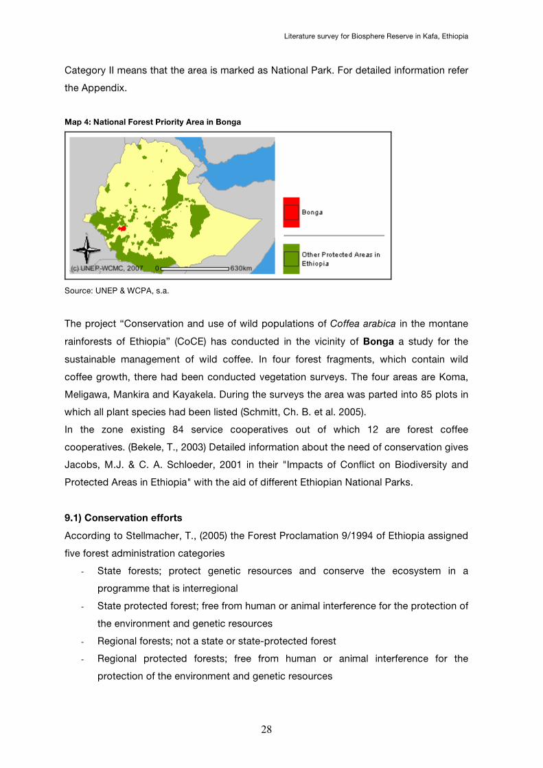
are some National Forest Priority Areas in Ethiopia. In Bonga exist one proposed with an
area of 161,423 hectares (UNEP & WCPA, s.a.). Bonga (Site Code: 29094) is situated at a
latitude of 7° 12' 35"N ( 7,210°) and a longitude of 36° 17' 24"E (36,290°), for details
please refer to Map 4 below and Map 8 in the appendix.
Literature survey for Biosphere Reserve in Kafa, Ethiopia
28
Category II means that the area is marked as National Park. For detailed information refer
the Appendix.
Map 4: National Forest Priority Area in Bonga
Source: UNEP & WCPA, s.a.
The project “Conservation and use of wild populations of Coffea arabica in the montane
rainforests of Ethiopia” (CoCE) has conducted in the vicinity of Bonga a study for the
sustainable management of wild coffee. In four forest fragments, which contain wild
coffee growth, there had been conducted vegetation surveys. The four areas are Koma,
Meligawa, Mankira and Kayakela. During the surveys the area was parted into 85 plots in
which all plant species had been listed (Schmitt, Ch. B. et al. 2005).
In the zone existing 84 service cooperatives out of which 12 are forest coffee
cooperatives. (Bekele, T., 2003) Detailed information about the need of conservation gives
Jacobs, M.J. & C. A. Schloeder, 2001 in their "Impacts of Conflict on Biodiversity and
Protected Areas in Ethiopia" with the aid of different Ethiopian National Parks.
9.1) Conservation efforts
According to Stellmacher, T., (2005) the Forest Proclamation 9/1994 of Ethiopia assigned
five forest administration categories
- State forests; protect genetic resources and conserve the ecosystem in a
programme that is interregional
- State protected forest; free from human or animal interference for the protection of
the environment and genetic resources
- Regional forests; not a state or state-protected forest
- Regional protected forests; free from human or animal interference for the
protection of the environment and genetic resources
Literature survey for Biosphere Reserve in Kafa, Ethiopia
29
- Private forests; developed by any legal person including, administered by the
regions
Detailed information about the Forest Proclamation 9/1994 is written in Stellmacher, T.,
(2005).
There are various efforts to conserve the forest coffee plants-gene pool in Kafa Region.
15 years ago an ex-situ conservation activity has been initiated in Jima zone. Since that
time over 2,000 coffee accessions has been collected and researched in the National
Coffee Research Centre at Jima.
The conservation had following goals:
- Collect and research the diversely coffee-plants to develop plants with high yield,
better quality, resistance to diseases, pests and abiotic stress.
- Conserve flora and fauna, microorganisms, soil, water in about 50 ha of the forest
coffee ecosystem (FCE) in western and Southwestern parts of Ethiopia.
- Conserve and preserve the coffee genepool (in-situ & ex-situ) to know the genetic
value of this area and of Ethiopia, too. Moreover for future breeding programmes
The current conservation status is that the Institute of Biodiversity Conservation and
Research (IBCR) maintains more than 4,000 accessions at the Chochie Biodiversity Unit
in Jima on 115 ha. Additionally the Jima Branch of the Institute of Agricultural Research
maintains now about 600 coffee types and 700 random selections that show varying
resistance to CBD. The In-situ conservation is not developed as well. In 1998 the
Coffee Improvement Project of Ethiopia suggested the establishment of three in situ
reserves known as the Kontir-Behan (20,000 ha), Boginda-Yeba (5,500 ha) and Geba-
Dogi River (18,600 ha). Until today the assigned Coffee and Tea Authority did not started
because of the financial lack (Gole, T.W., 2002b).
Before establish a conservation area it must be planed. The Forest Coffee Ecosystem is
not only important for genetic conservation; also there are millions of people who live in
this region who depend of it. The construction of a conservation area must respect the
people who live there and also the must be a maximum use of it. The Man and Biosphere
(MAB) Programme of UNESCO is considering this need (Gole, T.W., 2002b). To become a
biosphere reserve by MAB the proposed area has to be:
- representative in their biogeography
- contains animals, plants etc. which need to be conserved
- possibility for a sustainable development
- the size must be big enough to serve the three functions (explained below!)
- must have a zoning structure (core-, buffer, transition zone)
For the three functions a biosphere reserve must fulfil refer the appendix.
Literature survey for Biosphere Reserve in Kafa, Ethiopia
30
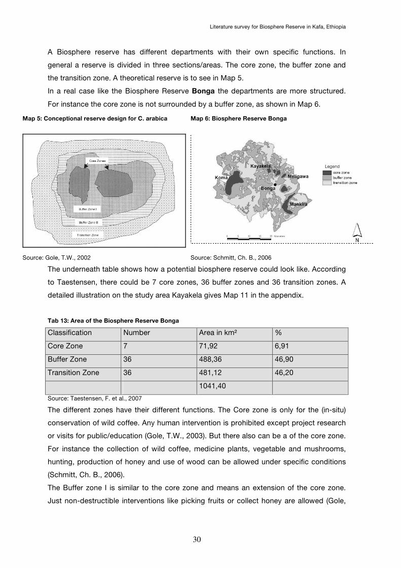
A Biosphere reserve has different departments with their own specific functions. In
general a reserve is divided in three sections/areas. The core zone, the buffer zone and
the transition zone. A theoretical reserve is to see in Map 5.
In a real case like the Biosphere Reserve Bonga the departments are more structured.
For instance the core zone is not surrounded by a buffer zone, as shown in Map 6.
Map 5: Conceptional reserve design for C. arabica Map 6: Biosphere Reserve Bonga
Source: Gole, T.W., 2002 Source: Schmitt, Ch. B., 2006
The underneath table shows how a potential biosphere reserve could look like. According
to Taestensen, there could be 7 core zones, 36 buffer zones and 36 transition zones. A
detailed illustration on the study area Kayakela gives Map 11 in the appendix.
Tab 13: Area of the Biosphere Reserve Bonga
Classification Number Area in km² %
Core Zone 7 71,92 6,91
Buffer Zone 36 488,36 46,90
Transition Zone 36 481,12 46,20
1041,40
Source: Taestensen, F. et al., 2007
The different zones have their different functions. The Core zone is only for the (in-situ)
conservation of wild coffee. Any human intervention is prohibited except project research
or visits for public/education (Gole, T.W., 2003). But there also can be a of the core zone.
For instance the collection of wild coffee, medicine plants, vegetable and mushrooms,
hunting, production of honey and use of wood can be allowed under specific conditions
(Schmitt, Ch. B., 2006).
The Buffer zone I is similar to the core zone and means an extension of the core zone.
Just non-destructible interventions like picking fruits or collect honey are allowed (Gole,

Literature survey for Biosphere Reserve in Kafa, Ethiopia
31
T.W., 2003a). Also semi wild coffee management is allowed except the cultivation of
coffee varieties (Schmitt, Ch. B., 2006).
In the Buffer zone II, also called socio-buffer, is the traditional semi-forest production
allowed. In the understorey small trees and plants which “disturbes” the coffee grow will
be eliminated. Besides coffee there is also a spice, which has a high value. One kilogram
of Aframomum corrorima brings more than 10 US$ on the local markets. This spice is
endemic for Ethiopia and depends to the wild coffee area. To ensure the success of the
core zone, the rules of the Buffer zones must be realised (Gole, T.W., 2003a).
Tab 14: Biological and social benefits of using buffer zones
Biological benefits Social benefits
- Provides extra protection from
human activities for the core zone
- Protects the core zone of the
reserve from biological change
- Provides a large forest unit for
conservation, with less species loss
through edge effects
- Extends habitat and thus population
size for large trees requiring more
space
- Provides a replenishment zone for
core area species
- Gives local people access to use the
forest by traditional practices
without depleting the core zone
- Compensates people for loss of
access to the strictly protected core
zone
- Permits local people to participate in
Conservation
- Safeguards traditional land use
rights and conservation practices
Source: Gole, T.W., 2003a
In the Transition zone all cultural and productive activities including animal husbandry are
allowed. Also introducing new plants and new techniques are allowed in case the people
have a benefit of it. If the production in the Transition zone is working and brings enough
benefit to the people, the danger of affect the core zone will be minimal (Gole, T.W.,
2003a).
As a sample for more detailed distribution of the different zones, refer map of the study
area Kayakela in the appendix.
10) GIS data and maps
In this chapter all available GIS data and maps on Kafa Region are listed. There is a
deficient supply of GIS data for the potential biosphere area. Only Reusing, M., (2000)
provides data on that area. He collected all available GIS data and assembled them.

Literature survey for Biosphere Reserve in Kafa, Ethiopia
32
In the 1970ies and 1980ies there had been some analogue satellite image interpretation
based on Landsat Satellite.
From 1986 to 1989 as well as from 1986 to 1990 there had been digital satellite image
interpretation based on Landsat. All data had been edited by ARC/INFO and IDRISI. As a
result of the 71 analogue images and the LANDAST images from 1986 to 1990 Reusing
got a declaration about the deforestation in Ethiopia. De facto the deforestation between
1986 and 1990 was 3,93 % or 45,055 km². That means an annual deforestation rate of
163,600 ha (Reusing, M., 2000).
Map 7: Human impact on Forests in SW Ethiopia from 1971 to 1997
Source: Reusing, M., 2000
Before the 1970ies the forest was completely covered by montane rainforests. The
situation changed resulting from the already described resettlement program of the state.
The new farmers brought a new farming system that was not adapted to the environment
(Reusing, M., 2000).
Based on black and white photographs of the years 1971 to 1975 it had been shown that
only 38,4 % of the original forest had been remained. The reason of the enourmous loss
of forest lies in the resettlement programme of the 1970ies and the attached higher need
of fuelwood and constructing timber (Reusing, M., 2000). There are two satellite images of
Bonga region available but without theme.
On the website of the UN Office for Coordination of Humanitarian Affairs (OCHA) there is
following map:
• Administrative Regions of Ethiopia
Literature survey for Biosphere Reserve in Kafa, Ethiopia
33
In "Reflections on environmental change and sustainable agriculture in areas of
autonomous trypanosomosis control" by Bourn, D. (2002) there are some graphics and
maps showing:
• Human Population Growth and Distribution in Ethiopia
• Forests and Deforestation in Ethiopia: 1973 – 1990
• Deforestation in South-Western Ethiopia: 1971-1997
In Conservation areas for wild coffee in Ethiopia: an exemplary planning concept based
on land use” by F. Taestensen et al. (2006) there are maps showing biosphere reserves in
Bonga:
• Biosphere reserve Bonga
• Zoning of the study area (Kayakela)
In “Genetic diversity of wild Coffea arabica populations in Ethiopia as a contribution to
conservation and use planning” by Kassahun Tesfaye Geletu there is a map that shows
the forest areas, the CoCE project sites.
In Christine B. Schmitt´s “Montane rainforest with wild Coffea Arabica in the Bonga region
(SW Ethiopia): plant diversity, wild coffee management and implications for conservation”
there are some maps:
• Forest cover in south-western and south-eastern Ethiopia with ecologically
suitable areas for wild coffee growth (potential coffee forest) and the borders of
the kingdom of Kafa in 1820 (GIS)
• Location of the studied forest fragments in south-western Ethiopia; potential
coffee forest: ecologically suitable areas for wild coffee growth; other forest:
forests above 2,000 m asl too high for wild coffee (GIS)
• Location and coffee management system of study plots in the forest fragments
Koma, Mankira, Meligawa and Kayakela
In the National Biodiversity Strategy and Action Plan by the Institute of Biodiversity
Conservation of Ethiopia 2005, there are maps:
• Agro Ecological Zone (AEZ) in Ethiopia
• Protected Areas in Ethiopia
In Conservation and use of coffee genetic resources in Ethiopia: challenges and
opportunities in the context current global situations by Gole, T.W. (2003a) there are two
graphics:
Literature survey for Biosphere Reserve in Kafa, Ethiopia
34
• Annual average ICO composite indicator price of green coffee on the world market
• Average annual retail price in three major coffee importing countries (ICO
database)
The Sustainable Poverty Alleviation in Kafa (SUPAKS, 2002) has three maps of the Kafa
region:
• Potential Areas with (Semi-) Forest Coffee Occurrence (Scale 1:500,000)
• Kafa Zone, Topographic Map (Scale 1:550,000)
• Kafa Zone, Land Cover / Use Map (Scale 1:550,000)
In the case study of Muys, B. (2003) "Forest Rehabilitation through Natural Regeneration
in Tigray, Ethiopia: From Fragments to Forests" there is one map showing the population
of Ethiopia:
• Total population density of Ethiopia
Stellmacher's "Governing the Ethiopian Coffee Forests: A Local Level Institutional
Analysis in Kaffa and Bale mountains" (2006) gives following maps:
• Forest cover in SW Ethiopia and contours of Bonga and Mena Angetu NFPA
(MODIS Vegetation Continuous Fields Satellite Image 2000)
• Forest cover and Bonga NFPA in Kaffa Zone
• The broad vicinity of Koma Forest
• GPS-confirmed boundaries of traditional forest property rights in Koma Forest
There existing two maps unknown made in the context of the Woody Biomass Project:
• Forest and potential coffee forest of Bonga, Yayu & Sheko
• Population density of Bonga, Yayu & Sheko
Matthias Reusing´s Change detection of natural high forests in Ethiopia using remote
sensing and GIS techniques includes two maps made in cooperation with the GTZ:
• Human impact on forest in Ethiopia from 1973 to 1990
• Human impact on forest in SW Ethiopia from 1971 to 1997
In the World Bank, 2004 there are about 50 maps showing the distribution of for instance
electricity, water access etc.
In World Bank, 2005 there is a map with two side maps:
• Energy Access Project
Literature survey for Biosphere Reserve in Kafa, Ethiopia
35
• Target Weredas for Sustainable Community Forestry Schemes
• Target Weredas for Farm Agro-forestry
In Surendra Kotecha's "Arabicas from the Garden of Eden: Coffea Aethiopica" (2007)
there are two maps:
• Map of Ethiopia: main forest areas in green and forest areas with coffee in light
green
• Detailed Map of Ethiopian forest areas in green and forest areas with coffee in light
green
11) Used literature and further readings
Abate, G. et al, Ed. (1995). Production efficiency analysis : the case of smallholder farming
in the coffee sector of Ethiopia and Kenya. Kiel.
Abbute, W.-S. (2003). Resettlement as a response to food insecurity: The case of
southern nations, nationalities, and peoples' region (SNNPR).
http://www.reliefweb.int/rw/rwb.nsf/AllDocsByUNID/40d57e6a23e15987c1256d58
004c4c85.
Abebe, B. (1998). Mythological and historical background of coffee. s.l.
Abebe, T. (2005). Diversity in homegarden agroforestry systems of Southern Ethiopia.
http://library.wur.nl/wda/dissertations/dis3720.pdf.
Acheson-Brown, D. G. (2003). Coffee oversupply and the need for managed-trade
regimes. s.l., Edwin Mellen Press.
African Development Bank (2007). Environmental and social impacts assesment.
http://www.afdb.org/pls/portal/docs/PAGE/ADB_ADMIN_PG/DOCUMENTS/OPER
ATIONSINFORMATION/ESIA%20_WITH%20RAP_%20SUMMARY%20JIMMA%2
0-%20MIZAN.PDF, African Development Bank.
African Development Fund (2006). Environmental and social impact assesment - Jima-
Mizan road upgrading project.
http://www.afdb.org/pls/portal/docs/PAGE/ADB_ADMIN_PG/DOCUMENTS/OPER
ATIONSINFORMATION/ESIA%20_WITH%20RAP_%20SUMMARY%20JIMMA%2
0-%20MIZAN.PDF, African Development Fund.
Alemu, T. (2005). The Land Issue and Environmental Change in Ethiopia. s.l.

Literature survey for Biosphere Reserve in Kafa, Ethiopia
36
Anonymous (1997). Environmental Policy. Environmental Protection Authority & Ministry
of Economic
Development and Cooperation.
http://www.basel.int/legalmatters/natleg/ethiopia01.pdf.
Anonymous (s.a.a). Colobus guereza. s.l.
Anonymous (s.a.b). The conservation strategy of Ethiopia project.
http://tcdc.undp.org/sie/experiences/vol3/Conservation%20Ethiopia.pdf, UNDP.
Asefa, S. & Lemi, A. (2001). Eradicating Rural Poverty and Food Insecurity in Ethiopia: The
Quest for Sustainable Institutions and Technologies.
http://www.waltainfo.com/ESRDF/Ethio_Forum/papers_C1.htm#_ftn4.
Bech, N. et al. (2004). Forest resources distribution. s.l., Kafa Zone Agricultural and
Natural Resource Desk & SUPAKS, Bonga.
Beining, A. M. (2007). Ecophysiological diversity of wild Coffea arabica populations in
Ethiopia: Drought adaptation mechanisms. Bonn, Bochum. http://hss.ulb.uni-
bonn.de/diss_online/landw_fak/2007/beining_alice/1145.pdf.
Bekele, M. & Bekele, T. (2005). Participatory forest management Ethiopia: Bonga and
Chilimo Final evaluation report. Addis Ababa. http://www.pfmp-
farmsos.org/Docs/bonga_chilimo_evaluation.pdf.
Bekele, M. (2001). The forest revenue system and government
expenditure on forestry in Ethiopia. Addis Ababa.
ftp://ftp.fao.org/docrep/fao/005/AC627E/AC627E00.pdf, FAO.
Bekele, M. (2002). The status of National Forest Priority Areas in SW Ethiopia. Final
Report. s.l.
Bekele, T. (2003). The potential of Bonga forest for certification - A case study.
http://www.pfmp-farmsos.org/Docs/bongaforest_certification.pdf.
Biology Online (s.a.). Eastern Africa and biodiversity. Overview of resources.
http://www.biology-online.org/articles/eastern_africa_biodiversity.html,
http://www.biology-online.org.
BirdLife IBA (2007). Factsheet ET050. Bonga forest.
http://www.birdlife.org/datazone/sites/index.html?action=SitHTMDetails.asp&sid=
6284&m=0#, BirdLife IBA.
Bizuwerk, A. et al. (s.a.). Application of GIS for Modeling Soil loss rate in Awash River
Basin, Ethiopia.
http://www.iwmi.cgiar.org/Assessment/files/pdf/publications/WorkingPapers/GIS
%20for%20modeling%20soil.pdf.
Bote, A. D. (2007). Physiological effect of Shade on growth and production of Organic
Coffee in Ethiopia.
Literature survey for Biosphere Reserve in Kafa, Ethiopia
37
Wageningen, Wageningen University The Netherlands.
Bourne, D. (2002). Reflections on environmental change and sustainable agriculture in
areas of autonomous trypanosomosis control. http://www.au-
ibar.org/isctrc/27Meeting/HTML/ENVIRONMENT.htm.
Central Statistical Agency of Ethiopia (CSA) (2007). Population. Addis Ababa.
http://www.csa.gov.et/text_files/national%20statistics%202006/Population.pdf,
Central Statistical Agency of Ethiopia.
Chikamai, B., Eyog-Matig, O. & Mbogga, M. (2002). Review and Appraisal on the
Status of Indigenous Fruits in Eastern Africa. Nairobi, Cotonu.
http://www.bioversityinternational.org/Information_Sources/Networks/saforgen/Re
view%20and%20Synthesis%20of%20Indigenous%20Fruits%20in%20East%20Af
rical.pdf.
Common Code for the Coffee Community Association (CCCCA) (2006). 4C Project - Info
Sheet. http://www.sustainable-coffee.net, Common Code for the Coffee
Community Association.
Conservation International (2005). Eastern afromontane biodiversity hotspot.
http://www.biodiversityhotspots.org/xp/Hotspots/afromontane/, Conservation
International.
Danulat, E. (2007). Literatur Revision BR Bonga. s.l.
Denich, M. et al. (2002). Conservation and use of the wild populations of Coffea arabica in
the montane rainforests of Ethiopia. Bonn, Addis Ababa. http://pt-uf.pt-
dlr.de/_media/01LM_0201.pdf, ZEF and EARO.
Denich, M. & Gatzweiler, F. (2006). Bemerkenswerte Ergebnisse zeigt das Coffea arabica
Projekt zu äthiopischem Wildkaffee. Bonn.
http://www.zef.de/fileadmin/webfiles/downloads/zefnews/ZEFnews19_deu.pdf,
ZEF.
Disaster Prevention and Preparedness Agency (DPPA) (2006). Map No.
001/DPPA/Administrative/11/SNNP. s.l., Disaster Prevention and Preparedness
Agency (DPPA).
E.U. (1998). Final report, national parks rehabilitation in southern Ethiopia project.
Brussels, E.U.
Engelmann, F. et al (2007). Conserving coffee genetic resources. Turrialba, Rome.
http://www.bioversityinternational.org/publications/Pdf/1244.pdf.
Environmental Protection Authority (1998). National action programme to combat
desertification.
http://www.unccd.int/actionprogrammes/africa/national/2000/ethiopia-eng.pdf,
Environmental Protection Authority.
Literature survey for Biosphere Reserve in Kafa, Ethiopia
38
Federal Democratic Republic of Ethiopia (2006). Jima-Mizan Road upgrading project.
appraisal report. Addis
Ababa.
http://www.afdb.org/pls/portal/docs/PAGE/ADB_ADMIN_PG/DOCUMENTS/OPER
ATIONSINFORMATION/THE%20JIMA-
MIZAN%20ROAD%20UPGRADING%20PROJECT.PDF, Federal Democratic
Republic of Ethiopia.
Faris, S. (2007). Starbucks vs. Ethiopia.
http://money.cnn.com/magazines/fortune/fortune_archive/2007/03/05/8401343/in
dex2.htm.
Farm Africa & SOS Sahel International (2004a). Agroforestry Project for soil & water
conservation, fodder and wood production in Bonga. Addis Ababa.
http://www.pfmp-farmsos.org/Docs/agroforestry_bonga.pdf, Farm Africa & SOS
Sahel International.
Farm Africa & SOS Sahel International (2004b). Forest Farming in Bonga (Project Profile).
Addis Ababa. http://www.pfmp-farmsos.org/Docs/forestfarming_bonga.pdf, Farm
Africa & SOS Sahel International.
Federal Democratic Republic of Ethiopia (FDRE) & Ministry of Finance and Economic
Development (MOFED) (2002). Ethiopia: Sustainable Development and
Poverty Reduction Program. Addis Ababa.
http://www.imf.org/External/NP/prsp/2002/eth/01/073102.pdf, Federal Democratic
Republic of Ethiopia (FDRE) & Ministry of Finance and Economic Development
(MOFED).
Feyera, S. (2006). Biodiversity and ecology of Afromontane rainforests with wild Coffea
arabica L. populations in Ethiopia. Bonn, ZEF.
Gatzweiler, F. et al. (2007). Why financial incentives can destroy economically
valuable biodiversity in Ethiopia. Bonn.
http://www.zef.de/fileadmin/webfiles/downloads/zef_dp/zef_dp_115.pdf, ZEF.
Gatzweiler, F. W. (2005). Institutionalising Biodiversity Conservation - The Case of
Ethiopian Coffee Forests. Bonn. http://www.conservationandsociety.org/cs-3-
1_11_kgatzweiler.pdf, ZEF.
GEF. (2006). ANNEXES TO PROJECT BRIEF .
http://www.gefweb.org/Documents/Council_Documents/GEF_C28/documents/5-
3-06494ETHPASANNEXES3May06.pdf
Gezahegn, P. (1996). Land tenure and natural resource management in Bonga Forest,
Southwest Ethiopia: the case of the Kafetcho and Manjo.

Literature survey for Biosphere Reserve in Kafa, Ethiopia
39
Gole, T. W. (2002). Human impacts on the Coffea arabica Genepool in Ethiopia and the
need for ist in situ conservation. Bonn, Addis Ababa.
http://www.ipgri.cgiar.org/Publications/727/pdf/0851995225Ch23.PDF, ZEF.
Gole, T. W. (2003a). Conservation and use of coffee genetic resources in Ethiopia:
challenges and opportunities in the context current global situations. Bonn.
http://www.coffee.uni-bonn.de/download/Tadesse-W-Gole_2003_Conservation-
and-Use-of-Coffee-genetic-Resources-in-Ethiopia.pdf.
Gole, T. W. (2003b). Vegetation of the Yayu forest in SW Ethiopia: impacts of human use
and implications for in situ conservation of wild Coffea arabica L. populations.
Goettingen.
http://www.zef.de/fileadmin/webfiles/downloads/zefc_ecology_development/ecol_
dev_10_Gole_text.pdf.
GTZ (2006). Erhalt der Kaffee Arabica Vielfalt in Äthiopien. In: Wertschöpfungsketten zum
Erhalt der biologischen Vielfalt für Landwirtschaft und Ernährung. Eschborn.
http://www2.gtz.de/dokumente/bib/06-0686.pdf, GTZ.
GTZ (s.a.). Inventory report of Boginda Forest. s.l., GTZ.
Hailu, G. (2000). Environment Law Ethiopia. Leuven.
http://www.dundee.ac.uk/cepmlp/journal/html/vol9/article9-12.pdf.
Holden, S. & Yohannes, H. (2001). Land and redistribution, tenure insecurity, and intensity
of production: a study of farm households in Southern Ethiopia. Washington D.C.,
International Food Policy Research Institute
Hotel Tourismus Revue (HTR) (2006). So wild ist Wildkaffee gar nicht. Bern.
www.htr.ch/doc/doc_download.cfm?34053EE1508B6B541A123AE106398C31,
Hotel Tourismus Revue (HTR).
IBCR & GTZ (2000). Socio-economic report on boginda natural forest. Forest Genetic
Resources Conservation Project. s.l., Institute of Biodiversity Conservation and
Research (IBCR) and German Technical Cooperation (GTZ).
IBCR & GTZ (s.a.). Technical report on woody species diversity of Boginda Forest. Report
of Forest Genetic Resources Conservation Project. s.l., Institute of Biodiversity
Conservation and Research (IBCR) and German Technical Cooperation (GTZ).
Hindorf, H. & Ritschel, A. (2006). Coffee leaf rust (Hemileia vastatrix) in the wild coffee
population (Coffea arabica) of Ethiopia (Abstract). Tuebingen, Bonn.
http://www.tropentag.de/2006/abstracts/full/597.pdf.
Jacobs, M.J. & Schloeder, C. A. (2001). Impacts of Conflict on Biodiversity and
Protected Areas in Ethiopia. Washington D.C.
http://www.worldwildlife.org/bsp/publications/africa/147/titlepage.htm.

Literature survey for Biosphere Reserve in Kafa, Ethiopia
40
Koehler, W. (2005). Kodex gegen die Kaffeekrise.
http://www2.gtz.de/dokumente/AKZ/deu/AKZ_2005_2/kaffee.pdf, GTZ.
Kotecha, S. (2007). Arabicas from the Garden of Eden: Coffea - Speciality Coffee
Association Europe. s.l.
Kubsa, A. (s.a.). Wajib: An Alternative Forest Conservation Approach for Ethiopia's
Forests. http://www.fao.org/DOCREP/ARTICLE/WFC/XII/0145-C2.HTM, FAO.
Kubsa, A. & Tadesse, T. (2002). Granting exclusive user rights to the forest dwellers in the
state-owned forest: the WAJIB approach in Ethiopia.
ftp://ftp.fao.org/docrep/fao/006/Y4807B/Y4807B07.pdf.
Kumar, S. (2000). Research and development options for enhancing income and
sustainability of farming systems in Kafa-Sheka zone of Ethiopia. an examplary
planning concept based on land use. s.l.
Lipp, H. (2003). Proceeding of Participatory Forest Management Working Group
Workshop. Bonga. http://www.pfmp-farmsos.org/Docs/bonga_workinggroup.pdf.
Mamo, A. (1992). Nutritional status of coffee soils of Keffa and Illubabor administrative
regions in south western Ethiopia. s.l.
Meilleur, B. A. & Hodgkin, T. (2003). In situ conservation of crop wild relatives: status and
trends.
http://www.bioversityinternational.org/Plants_and_Animals/Crop_Wild_Relatives/p
df/Meilleur_and_Hodgkin_Biol_Cons_2004.pdf.
Mekonnen, E. (2006). Bringing Kaffa forest coffee to the German market. Nairobi.
http://www.mamud.com/Docs/chains.pdf.
Mengistu, K. (2002). 3.4 Country paper: Ethiopia. Addis Ababa, Nairobi.
http://www.fao.org/DOCREP/006/J0628E/J0628E50.htm.
Mesfin Tekleab, Z. (1999). Land tenure and its impact on land resource utilisation in Kaffa-
Sheka administrative zone (Southwestern Ethiopia). Enschede.
Muys, B. (2003). Forest Rehabilitation through Natural Regeneration in Tigray, Ethiopia:
From Fragments to Forests. http://www.unep-
wcmc.org/forest/restoration/docs/Ethiopia.pdf, UNEP-WCMC.
NTFP/Non Timber Forest Products Research and Development Project (2006a).
Alternative Use Systems for the Remaining Cloud Forest in Ethiopia and the Role
of Arabica Coffee - A Cost-Benefit. Kiel. http://opus.zbw-
kiel.de/volltexte/2007/5535/pdf/EWP-2007-07.pdf, University of Kiel.
NTFP/Non Timber Forest Products Research and Development Project (2006b). Options
for Payment of Biodiversity Services from Ethiopian Coffee Forests. Wageningen.
http://forests.hud.ac.uk/links/biodiversity_series4.pdf, NTFP/Non Timber Forest
Products Research and Development Project. Partnership for the development of
Literature survey for Biosphere Reserve in Kafa, Ethiopia
41
environmental law and institutions in Africa (PADELIA) (s.a.). Compendium of
environmental laws of african countries/volume II: sectoralenvironmental laws and
regulations. http://www.unep.org/Padelia/publications/comp2Ethiopiapt1.pdf
http://www.unep.org/Padelia/publications/comp2Ethiopiapt2.pdf, Partnership for
the development of environmental law and institutions in Africa (PADELIA).
Philippe, L. (2003). Dynamics of coffee production systems in Kaffa. A case study from
two villages in Kaffa province of Ethiopia. Wageningen.
Reusing, M. (1998). Monitoring of forest resources in Ethiopia. Addis Ababa.
Reusing, M. (2000). Change detection of natural high forests in ethiopia using remote
sensing and GIS techniques. s.l.
Reusing, M. (2002). Extent and dynamics of deforestation in Ethiopia. Addis Ababa.
Richerzhagen, C. & Virchow, D. (2002). Sustainable Utilization of Crop Genetic Diversity
through Property Rights Mechanisms? The Case of Coffee Genetic Resources in
Ethiopia. Bonn.
http://www.zef.de/fileadmin/webfiles/downloads/conferences/bioecon_rome_cr_d
v.PDF.
Rojahn, A. (2006). Incentive mechanisms for a sustainable use system of the
montane rain forest in Ethiopia. Berlin, Kiel.
http://www.zef.de/module/register/media/32e7_Thesis_Rojahn.pdf.
Roubik, D. W. (2002). The value of bees to the coffee harvest.
http://striweb.si.edu/publications/PDFs/Roubik_coffeepollination.pdf.
Schmitt, C. B. (2006). Montane rainforest with wild Coffea arabica in the Bonga region
(SW Ethiopia): plant diversity, wild coffee management and implications for
conservation. Goettingen.
http://www.zef.de/fileadmin/webfiles/downloads/zefc_ecology_development/ecol_
dev_47_text.pdf.
Schmitt, C. B. et al (2005). Sustainable management of the montane rainforests with wild
coffee (Coffea arabica L.) in the Bonga region of southwest Ethiopia. Stuttgart-
Hohenheim. http://www.tropentag.de/2005/abstracts/full/562.pdf.
Scholz, V. & Kuhrt, C. (2007). Sustainable aroma in the coffee bean In: Entwicklung &
ländlicher Raum 2/2007. http://www.sustainable-coffee.net/download/press-pdf-
2007/ELR_Sustainable-aroma.pdf.
Senbeta, F. (2006). Effetcs of wild coffee management on species diversity in the
Afromontane rainforest of Ethiopia. Bonn. http://www.coffee.uni-
bonn.de/download/Feyera-Senbeta_Denich_2006_Effects-of-wild-coffee-
management-on-species-diversity.pdf.

Literature survey for Biosphere Reserve in Kafa, Ethiopia
42
SIPPO, FIBL & Naturland (2002). Part B: Production guidelines for organic Coffee, Cocoa
and Tea. Zurich. http://www.sippo.ch/files/publications/bio-kakao_b.pdf, SIPPO,
FIBL and Naturland.
Stellmacher, T. (2005). Institutional Factors shaping Coffee Forest Management in
Ethiopia. The Case of Bonga Forest/Kaffa Zone. Berlin. http://www.coffee.uni-
bonn.de/download/Stellmacher_2005_Institutional-Factors-shaping-Coffee-
Forest-Managment-in-Ethiopia.pdf.
Stellmacher, T. (2006). Governing the Ethiopian Coffee Forests: A Local Level Institutional
Analysis in Kaffa and Bale mountains. http://hss.ulb.uni-
bonn.de/diss_online/landw_fak/2007/stellmacher_till/1104.pdf.
SUPAKS (2002). Land cover mapping for Kafa Zone, SPNNR. s.l., SUPAKS.
Taestensen, F. et al (2007). Conservation areas for wild coffee in Ethiopia. s.l.
Tafesse, A. (1996). Agroecological zones of Southwest Ethiopia. Materialien zur
Ostafrikaforschung. Trier.
TAM Agribusiness (2004). Transforming lives & landscapes: linking agroforestry and
NTFPs farmers to the market. Addis Ababa. http://www.pfmp-
farmsos.org/Docs/linkingfarmerstomarket_bonga.pdf, TAM Agribusiness.
Soil and Water Conservation Team (2001). Proceedings National WOCAT Workshop,
Nazareth - Ethiopia (April 23 - 27, 2001). Nazareth.
http://www.wocat.net/MATERIALS/ProcEth01.pdf, Soil and Water Conservation
Team.
Teferi, M. H. (2006). Poverty Reduction & Sustainable Forest Management & Protection
through the Development of Non-Timber Forest Products & Community
Institutions in Southern Nations, Nationalities and Peoples Regional State YEAR
THREE - ANNUAL REPORT.
http://forests.hud.ac.uk/links/year_3_annual_report.pdf.
Tesfaye, T. (2006). Coffee forest conservation : local-level institutions influencing the
conservation and use of coffee forests in Southwest Ethiopia. s.l.
Tewolde, B. (1990). The importance of Ethiopian forests in the conservation of Arabica
coffee gene-pools, Institu für Allgemeine Botanik Hamburg.
The Kafa Forest Coffee Farmers Cooperative Union (KFCFCU) (s.a.). The union. Addis
Ababa. http://www.kafacoffeeunion.com/union.htm, The Kafa Forest Coffee
Farmers Cooperative Union (KFCFCU).
Tropenbos International (2006). Certification and NTFP certification. Wageningen.
http://www.tropenbos.nl/DRG/certification.htm, Tropenbos International.
UNDP-GEF (2006). Sustainable development of the protected area system of Ethiopia.
http://www.gefonline.org/projectDetails.cfm?projID=1239, UNDP-GEF.
Literature survey for Biosphere Reserve in Kafa, Ethiopia
43
UNEP (2002). Salient features of environmental laws in the federal democratic republic of
Ethiopia.
www.unep.org/dpdl/symposium/Documents/Country_papers/ETHIOPIA.doc,
UNEP.
UNEP-WCMC (2005). Guidelines for protected areas management categories.
http://www.gefonline.org/projectDetails.cfm?projID=1239, UNEP-WCMC.
UNESCO (2007). The Man and the Biosphere Programme.
http://www.unesco.org/mab/mabProg.shtml, UNESCO.
UNOCHA (UN-Office for the Coordination of Humanitarian Affairs) (2005). Ethiopia.
http://ochaonline2.un.org/Default.aspx?alias=ochaonline2.un.org/ethiopia. Addis
Ababa, UNOCHA (UN-Office for the Coordination of Humanitarian Affairs).
van der Beek, J. et al. (2006). Options for Payment of Biodiversity Services from Ethiopian
Coffee Forests. Student Research series No. 4. Wageningen.
http://forests.hud.ac.uk/links/biodiversity_series4.pdf, Non Timber Forest Products
Research and Development Project in S-W Ethiopia.
van Halteren, B. (1996). The socio-cultural and socioeconomic position of the Manjo in
the
Kaffecho-Shekacho Zone. Bonga.
Verdonk, M. et al. (2007). Governance of the emerging bio-energy markets. Utrecht.
http://www.lowcvp.org.uk/assets/reports/Governance%20biomarkets%20Verdon
k%20Faaij%20Dieperink%20Article%20Energy%20Policy.pdf.
Wakjira, D. T. (2007). Forest Cover Change and Socioeconomic Drivers in Southwest
Ethiopia. Bonn. http://www.coffee.uni-bonn.de/download/Dereje-
Tadesse_2007_Forest-Cover-Change-and-Socioeconomic-Drivers-in-SW-
Ethiopia.pdf.
UNEP & WCPA (s.a.). National Forest Priority Areas. http://www.unep-
wcmc.org/wdpa/sitedetails.cfm?siteid=29094&level=nat.
Wily, L. A. (2002). Participatory forest management in Africa: an overview of progress and
issues. ftp://ftp.fao.org/docrep/fao/006/y4807b/Y4807B03.pdf.
World Bank (2004). Background Report: Assesing Ethiopia Growth Potential and
Development Obstacles. Maps (Zonal Level) and Technical Appendix.
http://siteresources.worldbank.org/INTETHIOPIA/Resources/PREM/Technical%20
Note2.revised%20April13..pdf, World Bank.
World Bank (2005). Report No: 32482-ET. http://www-
wds.worldbank.org/servlet/WDSContentServer/WDSP/IB/2005/07/12/000090341_
20050712134802/Rendered/PDF/32482a.pdf, World Bank.
Zerfu, S. (2001). Household survey report of Boginda Forest. TECHNICAL REPORT

Literature survey for Biosphere Reserve in Kafa, Ethiopia
44
NO.SE. 2 Forest Genetic Resources Conservation Project., Institute of Biodiversity
Conservation and Research (IBCR) and German Technical Cooperation (GTZ).
Zerihun, W. (1999). Forests in the vegetation types of Ethiopia and their status in the
geographical context. A. D. Edwards S., Bekele T. and Haase G.
Zewdie, Y. (1998). Forest access: policy and reality in Kafa, Ethiopia.
www.metafro.be/leisa/2003/193-21_22.pdf.
Appendix
A) Conceptions
Alternate names for Kafa: KAFA, KEFA, KEFFA, KAFFA, CAFFINO, MANJO
Dialects: KAFA, BOSHA (GARO)
Alternate abreviations for Southern Nations, Nationalities, and People's Region (SNNPR):
SNNPS, SNNP's, SNNPR's.
Alternate names for Gimbo: Ginbo
Kebele: It's the smallest administrative unit in Ethiopia. It can be a neighbourhood or a
small group of organised people. The Kebele is part of a wereda.
Wereda: It's an administrative ward or local government equivalent to a district
Literature survey for Biosphere Reserve in Kafa, Ethiopia
45
B) Coffee
B.1) Introduction
"Wild Arabica coffee (Coffea arabica) has recently become a buzzword on the
international coffee specialty market (Watson 2004). Little is known, however, about the
actual abundance and distribution of wild coffee in its indigenous habitat. Southard (1918)
was impressed by “great forests of the wild coffee, which have not yet been touched”.
Subsequently, researchers have questioned if wild coffee exists at all, because centuries
of human activities in the forests of southwest Ethiopia might have strongly modified the
natural occurrence of
so-called wild coffee populations [...]. Until today, an official and internationally
recognized definition of wild coffee does not exist.
Reams of studies have been published on the ecological requirements of coffee, coffee
growth performance and coffee yields in plantations worldwide, but wild coffee in its
natural habitat has hardly received any attention [...]. Most descriptions of coffee
phenology and growth patterns in Ethiopian rainforests stem from early coffee
researchers [...]. Sketchy characterizations of wild coffee management systems exist, but
systematic studies on performance and yield of coffee in these systems are lacking [...].
Furthermore, conservation planning for the last Ethiopian rainforests with wild coffee
requires good knowledge on the actual impact of wild coffee management on coffee
populations and forest vegetation." (Schmitt, Ch. B., 2006)
"Coffee collected and managed inside the forest and planted in home gardens is the most
important cash crop [...]. In 2003/04, the Kafa Forest Coffee Farmers Cooperative Union
marketed 131 tons of coffee from forest coffee and semi-forest coffee systems with
Gimbo and Decha wereda contributing 50 % and 30 %". (Schmitt, Ch. B., 2006)
B.2) Ecological requirements of Coffea arabica
"Coffea arabica L. (Rubiaceae) grows naturally as bush or small tree in the shaded
understorey of montane rainforests in southwest and southeast Ethiopia. It occurs at
altitudes between 1,000 – 2,000 m asl with the most suitable range being 1,500 – 1,800 m
asl. Coffee supports annual rainfall between 900 – 1,300 mm/yr, but most appropriate are
conditions above 1,300 mm/yr with an optimum at 1,600 – 1,800 mm/yr [...]. The optimum
average annual temperature for coffee is 18 – 24 °C with contrasting seasons.
Coffee grown in plantations tolerates much wider altitude and rainfall ranges than coffee
grown in its original habitat. Coffee plantations occur from sea level up to 2,800 m asl.
Literature survey for Biosphere Reserve in Kafa, Ethiopia
46
Annual rainfall can be as low as 500 mm/yr if coffee is irrigated as for example in Harar
(east Ethiopia) [...].
Coffee grows on soils with varying acidity. Slightly acid soils, as present under montane
forest in southwest Ethiopia, are most suitable [...]. Since coffee is evergreen, it requires
sub-soil water at all times. Thus, deep soils with good water holding capacity are the
most suitable environment for coffee growth. The soil structure must also allow good
drainage because the surface feeding roots need a drier period for part of the year to slow
down growth, ripen the wood and initiate flower buds [...]. In heavy rainfall areas such as
Southwest Ethiopia coffee grows successfully in shallow clay soils with 15 – 20 cm depth.
Years with excessive rainfall or unusually long dry season can reduce the yields (Schmitt,
Ch. B., 2006).
Coffee is self-fertilizing, but fertilization by bees increases the yield substantially [...].
Monkeys, birds and rodents relish the sweet pulp of ripe coffee fruits and disseminate the
coffee seeds inside the forest [...]" (Schmitt, Ch. B., 2006).
B.3) Traditional management and processing practices
"Forest coffee is traditionally managed in forest coffee (FC) and semi-forest coffee (SFC)
systems [...]. They constitute 14 % and 54 % of the total coffee production area in
Ethiopia, respectively. In FC systems, only some competing undergrowth is removed. In
SFC systems, most undergrowth is removed and some emergent trees are cut. In semi
forest coffee plantations (17 % of the total coffee production area) farmers keep only few
shade trees and plant additional coffee seedlings collected in adjacent areas as well as
improved coffee varieties distributed by government extension workers and
nongovernmental organizations (NGOs). Home-garden coffee (9 %) and modern type
plantations (6 %) constitute small parts of the total coffee production area.
Coffee fruits consist of endosperm (beans) coated by testa (silverskin) and endocarp
(parchment), and surrounded by fleshy mesocarp (pulp). During wet coffee processing,
the mesocarp is removed with water (pulping) and the remaining fruit is fermented and
dried. Endocarp and testa are then removed mechanically (hulling) [...].
Traditionally, farmers harvest forest coffee by strip harvesting or by shaking trees and
collecting fruits from the ground. They thus obtain a mixture of ripe and immature fruits.
These are dried on the soil or sometimes on mats (dry processing). Thereafter, pulp,
parchment and silverskin are removed manually.
The quality of traditionally processed coffee beans is good enough for home
consumption, but does not meet export standards. Foreign coffee experts have long Wild
Coffea arabica in southwest Ethiopia complained that forest coffee should be harvested
Literature survey for Biosphere Reserve in Kafa, Ethiopia
47
perfectly ripe, but not from the ground, should be mechanically pulped and hulled (wet
processing), or dried on stools to avoid the smell of earth [...]." (Schmitt, Ch. B., 2006)
Further information about coffee systems gives Philippe, L.
B.4) Characterisation of wild coffee management systems
"The forest in Bonga region is classified into five management types according to degree
of disturbance and abundance of coffee as observed in the respective study plots."
(Schmitt, Ch. B., 2006)
No management/ undisturbed
"This forest type is unmanaged forest with undisturbed forest structure. The understorey
is deeply shaded and consists mostly of shrub and small tree species, that are more
competitive than coffee under these conditions. Coffee density is very low and the
individuals are sparsely distributed in the undergrowth. They are spindly and produce few
fruits. Due to the low number of mother trees and due to low productivity, there are only
few seedlings. In some forest parts, there are no mature mother trees at all, and seedlings
stem from seeds dispersed by birds or mammals. If the forest is extremely shaded and
humid, no coffee individuals are observed.
Local farmers sometimes remove woody plants from these forest parts, but there are no
regular coffee management activities. They collect green and red coffee fruits at the same
time because the cherries ripen asynchronously in the shaded forest, yields are low, and
the walking distance from the villages is usually large. Some remote coffee trees are not
visited annually, but on a more arbitrary basis.
This management intensity is the very first step in the domestication process of wild trees.
It is classified as “uncontrolled utilization” if the coffee fruits are only collected casually or
as “controlled utilization” if the collection is more or less systematic. In both cases,
though, there is no transformation of the natural vegetation composition and structure,
and propagules are only incidentally dispersed (Wiersum 1997)." (Schmitt, Ch. B., 2006)
(2) No management/ disturbed
"This is forest with disturbed vegetation structure and low coffee density. The disturbance
is caused by natural fall of trees or by people who removed poles and trunks to meet their
needs for wood and timber, but there is no explicit coffee management. The coffee
individuals have the same physiognomy as in unmanaged and undisturbed forest, and
their yields are also low. The fruits are picked by farmers on a casual basis." (Schmitt, Ch.
B., 2006)
(3) Forest coffee system
Literature survey for Biosphere Reserve in Kafa, Ethiopia
48
"This is forest with low coffee management intensity. Local farmers remove some shrubs
and small trees that compete with coffee, but the overall vegetation structure remains
undisturbed. As result of the management, coffee trees have more spatial space and are
less shaded. The density of coffee individuals and the number of large coffee trees is
therefore higher than in the unmanaged forest types. Coffee yields also increase."
(Schmitt, Ch. B., 2006)
"Local farmers visit forest coffee (FC) systems at least once a year to remove competing
undergrowth vegetation and systematically collect coffee fruits. FC systems are
considered as “owned” by individual farmers according to traditional land use
perceptions (Stellmacher in prep.). Thieving occurs, however, and therefore farmers prefer
to harvest early, i.e. even green fruits, in order to be ahead of thieves. The production of
coffee in FC systems is classified as “controlled utilization” involving systematic collection
and the limited transformation of forest structure to reduce competing vegetation
(Wiersum 1997)." (Schmitt, Ch. B., 2006)
C) Definition of category II National Park
The definition of category II National Park by the WORLD COMMISION ON PROTECTED AREAS:
"Protected area managed mainly for ecosystem protection and recreation" is copied from
http://www.unep-wcmc.org/wdpa/index.htm:
Definition Natural area of land and/or sea, designated to (a) protect the ecological integrity of one or more ecosystems for present and future generations, (b) exclude exploitation or occupation inimical to the purposes of designation of the area and (c) provide a foundation for spiritual, scientific, educational, recreational and visitor opportunities, all of which must be environmentally and culturally compatible. Objectives of Management
• to protect natural and scenic areas of national and international significance for spiritual, scientific, educational, recreational or tourist purposes;
• to perpetuate, in as natural a state as possible, representative examples of physiographic regions, biotic communities, genetic resources, and species, to provide ecological stability and diversity;
• to manage visitor use for inspirational, educational, cultural and recreational purposes at a level which will maintain the area in a natural or near natural state;
• to eliminate and thereafter prevent exploitation or occupation inimical to the purposes of designation;
• to maintain respect for the ecological, geomorphologic, sacred or aesthetic attributes which warranted designation; and
• to take into account the needs of indigenous people, including subsistence

Literature survey for Biosphere Reserve in Kafa, Ethiopia
49
resource use, in so far as these will not adversely affect the other objectives of management.
Guidance for Selection
• The area should contain a representative sample of major natural regions, features or scenery, where plant and animal species, habitats and geomorphological sites are of special spiritual, scientific, educational, recreational and tourist significance.
• The area should be large enough to contain one or more entire ecosystems not materially altered by current human occupation or exploitation.
Organizational Responsibility Ownership and management should normally be by the highest competent authority of the nation having jurisdiction over it. However, they may also be vested in another level of government, council of indigenous people, foundation or other legally established body which has dedicated the area to long-term conservation.” Equivalent Category in 1978 System National Park
D) UNESCO Biosphere Reserve
Definition: Core Area
Source: Taestensen, F. et al., 2007
Literature survey for Biosphere Reserve in Kafa, Ethiopia
50
Definition: Buffer Zone
Source: Taestensen, F. et al., 2007
Definition: Transition Area
Source: Taestensen, F. et al., 2007
Tab 15: Functions of Biosphere Reserve by MAB/UNESCO
Conservation contribute to the conservation of landscapes, ecosystems, species and
genetic variation
Development foster economic and human development which is sociocultural and
ecologically sustainable
Logistic
support
support for demonstration projects, environmental education and training,
research and monitoring related to local, regional, national and global
issues of conservation and sustainable development
Source: Taestensen, F. et al., 2007
E) Maps & Tabs
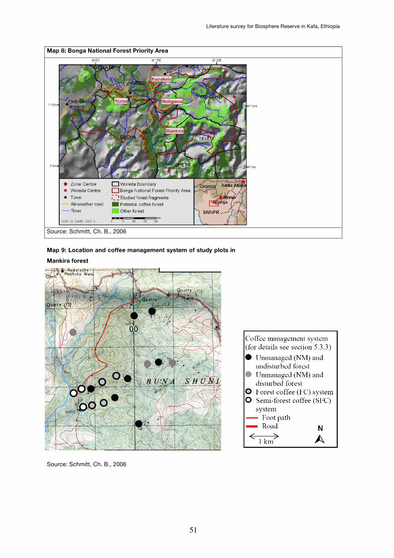
Literature survey for Biosphere Reserve in Kafa, Ethiopia
51
Map 8: Bonga National Forest Priority Area
Source: Schmitt, Ch. B., 2006
Map 9: Location and coffee management system of study plots in
Mankira forest
Source: Schmitt, Ch. B., 2006
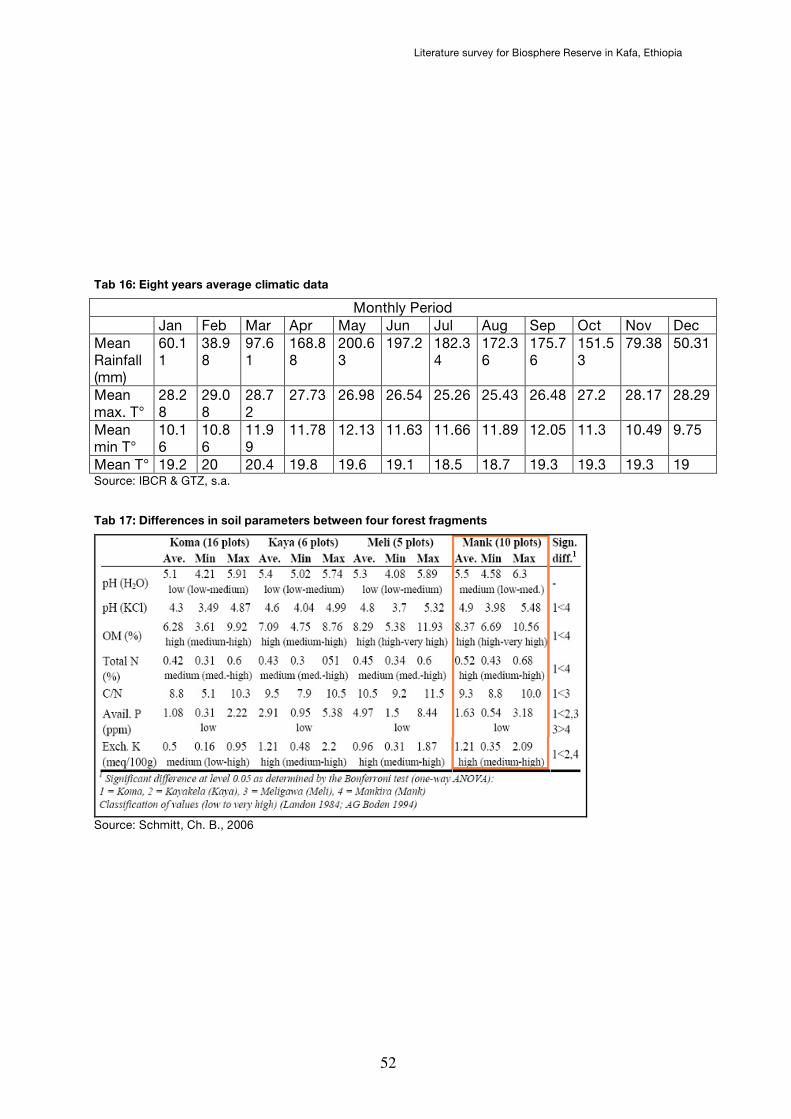
Literature survey for Biosphere Reserve in Kafa, Ethiopia
52
Tab 16: Eight years average climatic data
Monthly Period Jan Feb Mar Apr May Jun Jul Aug Sep Oct Nov Dec Mean Rainfall (mm)
60.11
38.98
97.61
168.88
200.63
197.2 182.34
172.36
175.76
151.53
79.38 50.31
Mean max. T°
28.28
29.08
28.72
27.73 26.98 26.54 25.26 25.43 26.48 27.2 28.17 28.29
Mean min T°
10.16
10.86
11.99
11.78 12.13 11.63 11.66 11.89 12.05 11.3 10.49 9.75
Mean T° 19.2 20 20.4 19.8 19.6 19.1 18.5 18.7 19.3 19.3 19.3 19 Source: IBCR & GTZ, s.a.
Tab 17: Differences in soil parameters between four forest fragments
Source: Schmitt, Ch. B., 2006
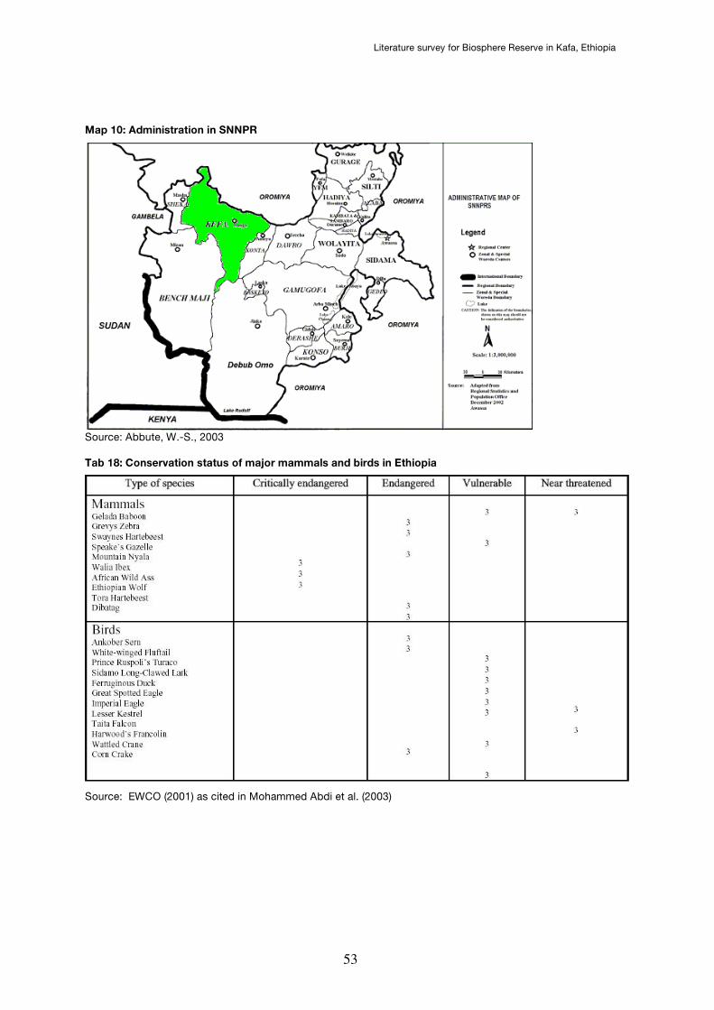
Literature survey for Biosphere Reserve in Kafa, Ethiopia
53
Map 10: Administration in SNNPR
Source: Abbute, W.-S., 2003
Tab 18: Conservation status of major mammals and birds in Ethiopia
Source: EWCO (2001) as cited in Mohammed Abdi et al. (2003)
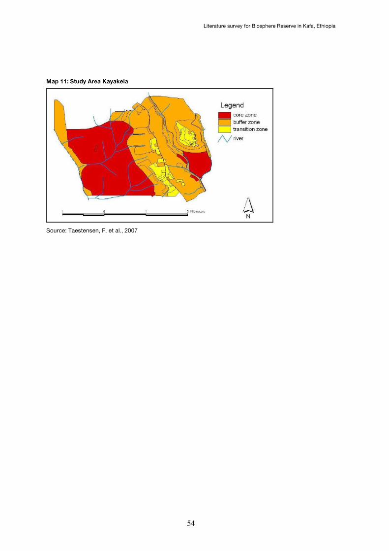
Literature survey for Biosphere Reserve in Kafa, Ethiopia
54
Map 11: Study Area Kayakela
Source: Taestensen, F. et al., 2007