linlithgow loch sssi scm 2013 scottish natural · pdf filereport prepared by: ecus ltd....
TRANSCRIPT
Report prepared by: Ecus Ltd. (Stirling)
Scion House Stirling University
Innovation Park, Stirling
FK9 4NF 01786 458 017
November 2013
Linlithgow Loch SSSI SCM 2013
Scottish Natural Heritage
Linlithgow Loch SSSI SCM 2013 Scottish Natural Heritage
ii
Ecus Ltd
Report to: Scottish Natural Heritage
Report Title: Linlithgow Loch SSSI SCM 2013
Revision: Draft
Issue Date: November 2013
Report Ref: 4641/LIN
Originated By:
Emma Baxter Nick Stewart Graduate Aquatic Ecologist Associate Macrophyte Expert
Date: 21
st November 2013
Reviewed By:
Sarah Clarke
Aquatic Ecology Team Manager Date: 25th November 2013
Approved By:
Ian Griffin
Principal Hydroecologist Date: 29th November 2013
Prepared by: Ecus Ltd. (Stirling)
Scion House Stirling University Innovation Park,
Stirling FK9 4NF
01786 458 017
The report and the site assessments carried out by Ecus on behalf of the client in accordance with the agreed terms of contract and/or written agreement form the agreed Services. The Services were performed by Ecus with the skill and care ordinarily exercised by a reasonable Environmental Consultant at the time the Services were performed. Further, and in particular, the Services were performed by Ecus taking into account the limits of the scope of works required by the client, the time scale involved and the resources, including financial and manpower resources, agreed between Ecus and the client.
Other than that expressly contained in the paragraph above, Ecus provides no other representation or warranty whether express or implied, in relation to the services.
This report is produced exclusively for the purposes of the client. Ecus is not aware of any interest of or reliance by any party other than the client in or on the services. Unless expressly provided in writing, Ecus does not authorise, consent or condone any party other than the client relying upon the services provided. Any reliance on the services or any part of the services by any party other than the client is made wholly at that party’s own and sole risk and Ecus disclaims any liability to such parties.
This report is based on site conditions, regulatory or other legal provisions, technology or economic conditions at the time of the Service provision. These conditions can change with time and reliance on the findings of the Services under changing conditions should be reviewed.
Ecus accepts no responsibility for the accuracy of third party data used in this report.

Linlithgow Loch SSSI SCM 2013 Scottish Natural Heritage
iii
Contents
1. INTRODUCTION ............................................................................................... 1
2. METHODS ........................................................................................................ 1
3. CONDITION ASSESSMENT ............................................................................. 1
4. CONCLUSIONS AND SUMMARY ..................................................................... 8
5. REFERENCES .................................................................................................. 9
APPENDICES
Linlithgow Loch SSSI SCM 2013 Scottish Natural Heritage
1
1. Introduction
1.1.1 Linlithgow Loch is the largest natural freshwater loch in the Lothian area. It is designated as a SSSI for a good representation of eutrophic aquatic and emergent plant communities (SNH, 2008). Situated in the grounds of Linlithgow Palace, it is surrounded by urban areas to the south and west. The M9 runs to the north, with arable fields behind. The entire perimeter of the loch is accessible to the public. The waterbody itself is used for angling and recreational watersports, predominantly sailing with some associated powerboats.
1.1.2 This report details the 2013 Site Condition Monitoring (SCM) survey of the eutrophic standing water feature of Linlithgow Loch SSSI.
2. Methods
2.1.1 This SCM survey was conducted on 5th September 2013 by Nick Stewart and Ecus Aquatic Ecologist Emma Baxter. The survey methods followed those set out in the Common Standards Monitoring Guidance for Standing Waters (JNCC, 2009), using a combination of paired wader/perimeter and boat/perimeter surveys.
2.1.2 A previous SCM survey was undertaken in 2004 (CEH 2004) using three wader/perimeter surveys. However, one of the sectors (Sector 3) recorded no aquatic vegetation due to overshading by trees and the report recommended that this sector be moved to a better location.
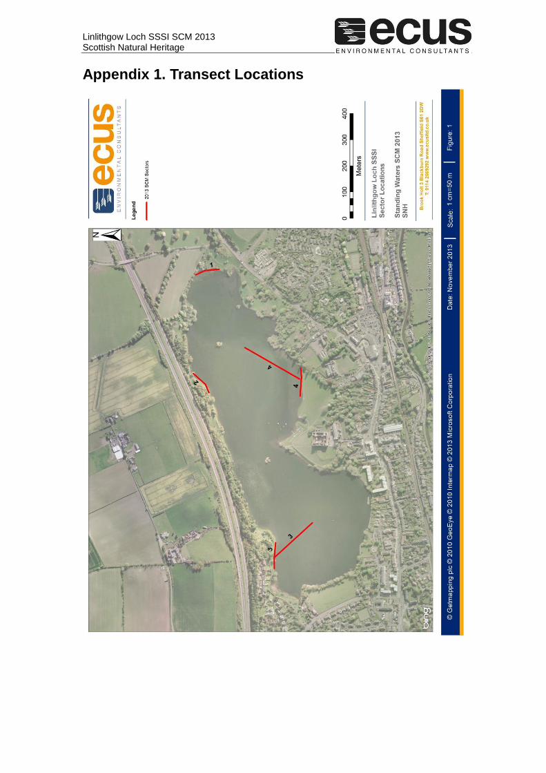
2.1.3 In 2013, four sectors were positioned around the loch, representative of the different habitats identified at Linlithgow Loch. Sectors 1 and 2 were located in the same position as in the 2004 SCM survey, with wader transects employed for direct comparison of the data. As recommended in CEH (2004), Sector 3 was relocated further north around the shoreline where there is much less shade. Due to the large size of the loch, an additional sector (Sector 4) was positioned by the palace. It soon became clear during the survey visit that there was very little vegetation in the shallows but much more vegetation offshore. It was therefore considered more valuable to conduct two boat transects for these new/repositioned sectors. In addition, the screen at the outfall was checked for stranded vegetation. Figure 1 (Appendix 1) shows the location of the 2013 survey transects.
2.1.4 Boat access was gained from the ramp off the Peel below Linlithgow Palace. The entrance to the Peel is adjacent to the gate of the Palace.
3. Condition Assessment
3.1.1 Photographs of the general site character are presented in Appendix 2. Water quality data are presented in Appendix 3.
3.1.2 Linlithgow Loch is a type I loch “Widespread, mostly moderately large, base rich lowland lakes with Chara spp., Myriophyllum spicatum and a diversity of Potamogeton species” of Duigan et al. (2006)
3.1.3 This condition assessment is based on the targets set for the generic attributes (biological and non-biological) listed for H3150 Natural eutrophic lakes with Magnopotamion or Hydrocharition-type vegetation feature in the
Linlithgow Loch SSSI SCM 2013 Scottish Natural Heritage
2
Favourable Condition Table (FCT) 5 in the Common Standards Monitoring Guidance for Standing Waters (JNCC, 2009).
3.1.4 For targets involving the assessment of change, the results of the 2013 survey were compared with previous data from the 1997 NCC/SNH Scottish Loch Survey Project (SNH 1997) and the 2004 SCM survey (CEH 2004). Macrophyte species lists for the current and previous surveys are presented in Appendix 4. Additional historic information on selected species is provided by Smith et al. (2002)
3.1.5 Both of the previous surveys were based on investigation of the shoreline without the use of a boat. This means that the open water communities were poorly recorded. In 2013, very little vegetation was found in the shallows but significant beds of vegetation occurred offshore. The data from 2004 suggests that this was also the case in that survey, with submerged vegetation reached in most cases only at the >75 cm depth sample points of the wader transects. This complicates direct comparisons with the previous surveys and some allowance for this was made in the assessment.
3.1.6 The results of the SCM assessment are summarised in Table 1 below.
Linlithgow SSSI SCM 2013 Scottish Natural Heritage
3
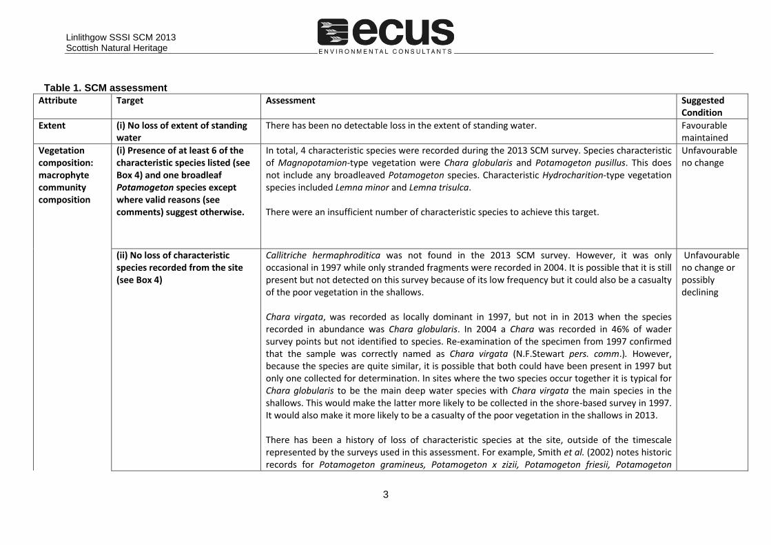
Table 1. SCM assessment
Attribute Target Assessment Suggested Condition
Extent (i) No loss of extent of standing water
There has been no detectable loss in the extent of standing water. Favourable maintained
Vegetation composition: macrophyte community composition
(i) Presence of at least 6 of the characteristic species listed (see Box 4) and one broadleaf Potamogeton species except where valid reasons (see comments) suggest otherwise.
In total, 4 characteristic species were recorded during the 2013 SCM survey. Species characteristic of Magnopotamion-type vegetation were Chara globularis and Potamogeton pusillus. This does not include any broadleaved Potamogeton species. Characteristic Hydrocharition-type vegetation species included Lemna minor and Lemna trisulca. There were an insufficient number of characteristic species to achieve this target.
Unfavourable no change
(ii) No loss of characteristic species recorded from the site (see Box 4)
Callitriche hermaphroditica was not found in the 2013 SCM survey. However, it was only occasional in 1997 while only stranded fragments were recorded in 2004. It is possible that it is still present but not detected on this survey because of its low frequency but it could also be a casualty of the poor vegetation in the shallows. Chara virgata, was recorded as locally dominant in 1997, but not in in 2013 when the species recorded in abundance was Chara globularis. In 2004 a Chara was recorded in 46% of wader survey points but not identified to species. Re-examination of the specimen from 1997 confirmed that the sample was correctly named as Chara virgata (N.F.Stewart pers. comm.). However, because the species are quite similar, it is possible that both could have been present in 1997 but only one collected for determination. In sites where the two species occur together it is typical for Chara globularis to be the main deep water species with Chara virgata the main species in the shallows. This would make the latter more likely to be collected in the shore-based survey in 1997. It would also make it more likely to be a casualty of the poor vegetation in the shallows in 2013. There has been a history of loss of characteristic species at the site, outside of the timescale represented by the surveys used in this assessment. For example, Smith et al. (2002) notes historic records for Potamogeton gramineus, Potamogeton x zizii, Potamogeton friesii, Potamogeton
Unfavourable no change or possibly declining
Linlithgow SSSI SCM 2013 Scottish Natural Heritage
4
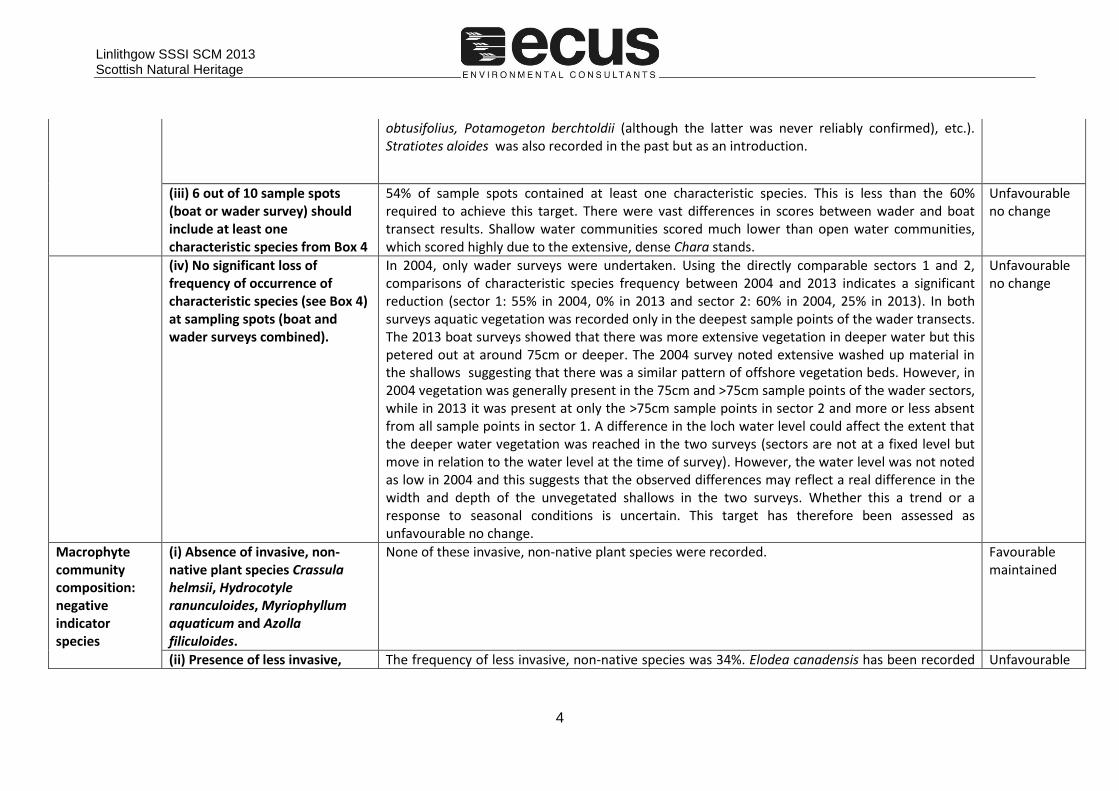
obtusifolius, Potamogeton berchtoldii (although the latter was never reliably confirmed), etc.). Stratiotes aloides was also recorded in the past but as an introduction.
(iii) 6 out of 10 sample spots (boat or wader survey) should include at least one characteristic species from Box 4
54% of sample spots contained at least one characteristic species. This is less than the 60% required to achieve this target. There were vast differences in scores between wader and boat transect results. Shallow water communities scored much lower than open water communities, which scored highly due to the extensive, dense Chara stands.
Unfavourable no change
(iv) No significant loss of frequency of occurrence of characteristic species (see Box 4) at sampling spots (boat and wader surveys combined).
In 2004, only wader surveys were undertaken. Using the directly comparable sectors 1 and 2, comparisons of characteristic species frequency between 2004 and 2013 indicates a significant reduction (sector 1: 55% in 2004, 0% in 2013 and sector 2: 60% in 2004, 25% in 2013). In both surveys aquatic vegetation was recorded only in the deepest sample points of the wader transects. The 2013 boat surveys showed that there was more extensive vegetation in deeper water but this petered out at around 75cm or deeper. The 2004 survey noted extensive washed up material in the shallows suggesting that there was a similar pattern of offshore vegetation beds. However, in 2004 vegetation was generally present in the 75cm and >75cm sample points of the wader sectors, while in 2013 it was present at only the >75cm sample points in sector 2 and more or less absent from all sample points in sector 1. A difference in the loch water level could affect the extent that the deeper water vegetation was reached in the two surveys (sectors are not at a fixed level but move in relation to the water level at the time of survey). However, the water level was not noted as low in 2004 and this suggests that the observed differences may reflect a real difference in the width and depth of the unvegetated shallows in the two surveys. Whether this a trend or a response to seasonal conditions is uncertain. This target has therefore been assessed as unfavourable no change.
Unfavourable no change
Macrophyte community composition: negative indicator species
(i) Absence of invasive, non-native plant species Crassula helmsii, Hydrocotyle ranunculoides, Myriophyllum aquaticum and Azolla filiculoides.
None of these invasive, non-native plant species were recorded. Favourable maintained
(ii) Presence of less invasive, The frequency of less invasive, non-native species was 34%. Elodea canadensis has been recorded Unfavourable
Linlithgow SSSI SCM 2013 Scottish Natural Heritage
5
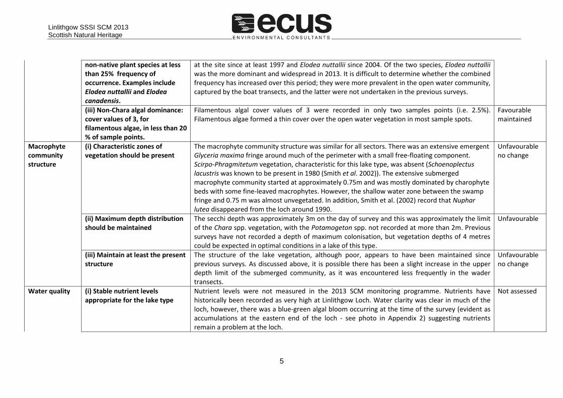
non-native plant species at less than 25% frequency of occurrence. Examples include Elodea nuttallii and Elodea canadensis.
at the site since at least 1997 and Elodea nuttallii since 2004. Of the two species, Elodea nuttallii was the more dominant and widespread in 2013. It is difficult to determine whether the combined frequency has increased over this period; they were more prevalent in the open water community, captured by the boat transects, and the latter were not undertaken in the previous surveys.
(iii) Non-Chara algal dominance: cover values of 3, for filamentous algae, in less than 20 % of sample points.
Filamentous algal cover values of 3 were recorded in only two samples points (i.e. 2.5%). Filamentous algae formed a thin cover over the open water vegetation in most sample spots.
Favourable maintained
Macrophyte community structure
(i) Characteristic zones of vegetation should be present
The macrophyte community structure was similar for all sectors. There was an extensive emergent Glyceria maxima fringe around much of the perimeter with a small free-floating component. Scirpo-Phragmitetum vegetation, characteristic for this lake type, was absent (Schoenoplectus lacustris was known to be present in 1980 (Smith et al. 2002)). The extensive submerged macrophyte community started at approximately 0.75m and was mostly dominated by charophyte beds with some fine-leaved macrophytes. However, the shallow water zone between the swamp fringe and 0.75 m was almost unvegetated. In addition, Smith et al. (2002) record that Nuphar lutea disappeared from the loch around 1990.
Unfavourable no change
(ii) Maximum depth distribution should be maintained
The secchi depth was approximately 3m on the day of survey and this was approximately the limit of the Chara spp. vegetation, with the Potamogeton spp. not recorded at more than 2m. Previous surveys have not recorded a depth of maximum colonisation, but vegetation depths of 4 metres could be expected in optimal conditions in a lake of this type.
Unfavourable
(iii) Maintain at least the present structure
The structure of the lake vegetation, although poor, appears to have been maintained since previous surveys. As discussed above, it is possible there has been a slight increase in the upper depth limit of the submerged community, as it was encountered less frequently in the wader transects.
Unfavourable no change
Water quality (i) Stable nutrient levels appropriate for the lake type
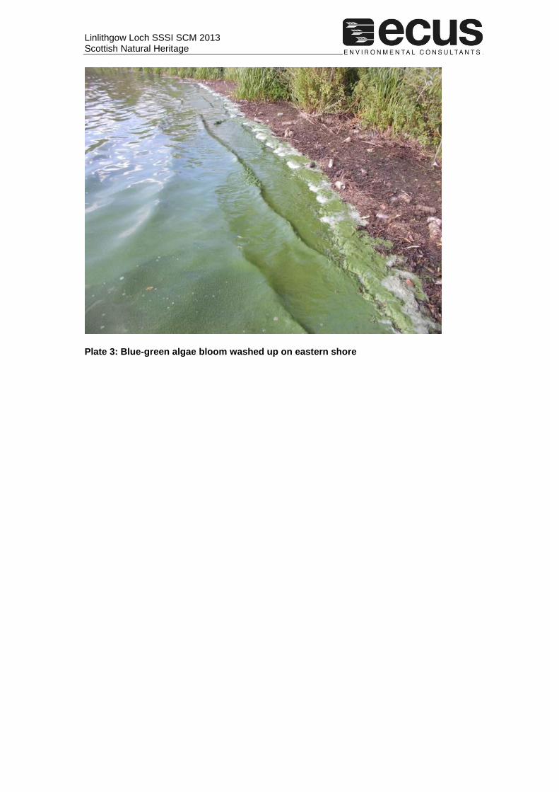
Nutrient levels were not measured in the 2013 SCM monitoring programme. Nutrients have historically been recorded as very high at Linlithgow Loch. Water clarity was clear in much of the loch, however, there was a blue-green algal bloom occurring at the time of the survey (evident as accumulations at the eastern end of the loch - see photo in Appendix 2) suggesting nutrients remain a problem at the loch.
Not assessed
Linlithgow SSSI SCM 2013 Scottish Natural Heritage
6
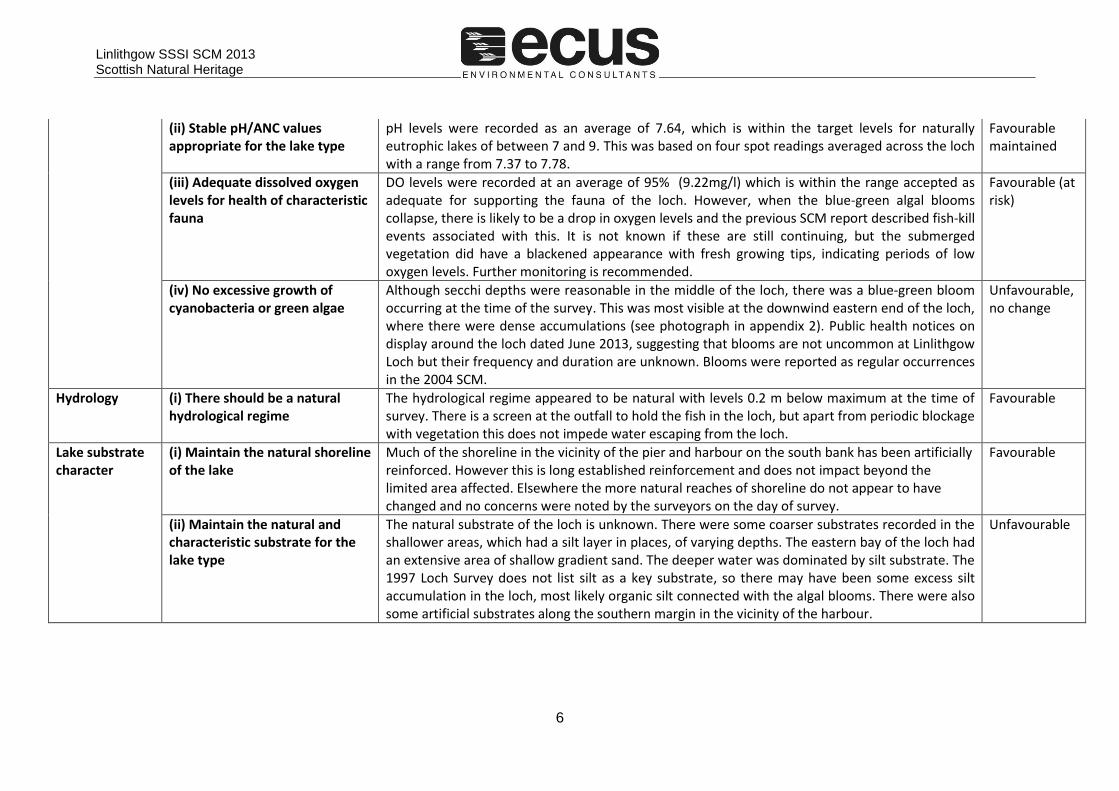
(ii) Stable pH/ANC values appropriate for the lake type
pH levels were recorded as an average of 7.64, which is within the target levels for naturally eutrophic lakes of between 7 and 9. This was based on four spot readings averaged across the loch with a range from 7.37 to 7.78.
Favourable maintained
(iii) Adequate dissolved oxygen levels for health of characteristic fauna
DO levels were recorded at an average of 95% (9.22mg/l) which is within the range accepted as adequate for supporting the fauna of the loch. However, when the blue-green algal blooms collapse, there is likely to be a drop in oxygen levels and the previous SCM report described fish-kill events associated with this. It is not known if these are still continuing, but the submerged vegetation did have a blackened appearance with fresh growing tips, indicating periods of low oxygen levels. Further monitoring is recommended.
Favourable (at risk)
(iv) No excessive growth of cyanobacteria or green algae
Although secchi depths were reasonable in the middle of the loch, there was a blue-green bloom occurring at the time of the survey. This was most visible at the downwind eastern end of the loch, where there were dense accumulations (see photograph in appendix 2). Public health notices on display around the loch dated June 2013, suggesting that blooms are not uncommon at Linlithgow Loch but their frequency and duration are unknown. Blooms were reported as regular occurrences in the 2004 SCM.
Unfavourable, no change
Hydrology (i) There should be a natural hydrological regime
The hydrological regime appeared to be natural with levels 0.2 m below maximum at the time of survey. There is a screen at the outfall to hold the fish in the loch, but apart from periodic blockage with vegetation this does not impede water escaping from the loch.
Favourable
Lake substrate character
(i) Maintain the natural shoreline of the lake
Much of the shoreline in the vicinity of the pier and harbour on the south bank has been artificially reinforced. However this is long established reinforcement and does not impact beyond the limited area affected. Elsewhere the more natural reaches of shoreline do not appear to have changed and no concerns were noted by the surveyors on the day of survey.
Favourable
(ii) Maintain the natural and characteristic substrate for the lake type
The natural substrate of the loch is unknown. There were some coarser substrates recorded in the shallower areas, which had a silt layer in places, of varying depths. The eastern bay of the loch had an extensive area of shallow gradient sand. The deeper water was dominated by silt substrate. The 1997 Loch Survey does not list silt as a key substrate, so there may have been some excess silt accumulation in the loch, most likely organic silt connected with the algal blooms. There were also some artificial substrates along the southern margin in the vicinity of the harbour.
Unfavourable
Linlithgow SSSI SCM 2013 Scottish Natural Heritage
7
Sediment load (i) Maintain natural sediment load
It is hard to ascertain the naturalness of the current sediment loading based on this visit although no significant silt input was observed at the inflow stream at the eastern end. The previous SCM reported anecdotal concerns of sediment loading in the runoff from car parks and agricultural land, as well as loading from the catchment entering the loch through the inflow streams. Further assessment would be needed to determine the extent; in the absence of this, the condition is recorded as favourable at risk.
Favourable (at risk)
Indicators of local distinctiveness
(i) Maintain distinctive elements (e.g. Rare plant or invertebrate species, habitat features) at current extent/levels and/or in current locations)
No distinctive elements are noted in the citation. Of the species recorded, Potamogeton pusillus and Chara globularis are rare in West Lothian (Smith et al. 2002). Zannichellia palustris, Chara virgata and Callitriche hermaphroditica recorded in 1997 and/or 2004 but not in 2013 are also rare in West Lothian. Smith et al. (2002) also gives numerous other locally rare species recorded in the past from the loch, including at least 8 species of Potamogeton. Although some have not been seen for many decades, more recent losses include Nuphar lutea (c.1990), Potamogeton friesii (post-1977) and Potamogeton berchtoldii (post-1990).
Unfavourable, possibly declining
Linlithgow Loch SSSI SCM 2013 Scottish Natural Heritage
8
4. Conclusions and Summary
4.1.1 The macrophyte community at Linlithgow Loch lacks sufficient indicator species and has a high frequency of less invasive non-native species. The shallow water zones were sparsely vegetated; characteristic plants were rare and limited to the deeper sample spots, with two characteristic species seen in 1997 and/or 2004 not seen on this survey. Boat surveys found extensive beds of Chara globularis and this was the main contributor to the characteristic vegetation scores. This was surprising considering the high nutrient levels, although this species can tolerate higher nutrient levels than other charophytes under certain conditions. The Chara was accompanied by locally abundant Elodea nuttallii, with frequent Lemna trisulca, occasional Potamogeton pectinatus, Potamogeton pusillus and Elodea canadensis.
4.1.2 The reason for the poor vegetation in the shallows is unclear. Wind exposure affects significant parts of the loch margin but even in sheltered parts the shallows are poorly vegetated. Filamentous algal covers were significantly higher in 2004 compared to 2013 and it may be that at various times the accumulations of filamentous algae, flotsam from the deeper water vegetation and washed in blue-green algae combine to suppress any growth in the shallows. Comparison between wader transects in 2004 and 2013 suggest that the upper limit of the deeper water vegetation may have been at a greater depth in 2013. However it is unclear whether this is a trend or variation in response to seasonal conditions and this would benefit from further investigation.
4.1.3 It is recommended that future surveys at the site include boat transects as characteristic species would not have been recorded through shore based methods alone on this visit.
4.1.4 Water quality remains the main concern at Linlithgow Loch. Although nutrient levels were not tested in 2013, nutrient levels and silt appear to remain artificially high, reflected in the blue-green algal blooms, blackened condition of much of the submerged vegetation and poor vegetation in the shallows. There is a need to identify and address the key nutrient inputs to the loch.To conclude, it is recommended that the eutrophic standing water habitat feature of Linlithgow Loch SSSI be classified as UNFAVOURABLE NO CHANGE. The macrophyte community has some indicators of natural eutrophic conditions, but may be declining whilst external pressures threaten the natural nutrient levels and hydrology.
Linlithgow Loch SSSI SCM 2013 Scottish Natural Heritage
9
5. References
CEH (2004). Standing Water SCM Condition Monitoring Form. Linlithgow Loch SSSI. Duigan, C., Kovach, W. & Palmer, M.A. (2006) Vegetation communities of British Lakes; a revised classification. Joint Nature Conservation Committee, Peterborough. JNCC (2009). Common Standards Monitoring Guidance for Standing Waters. Revised 10 November 2009, Joint Nature Conservation Committee, Peterborough. Smith, P.M., Dixon, R.O.D. & Cochrane, M.P. (2002) Plant life of Edinburgh and the Lothians. Edinburgh Univerity Press. SNH (1997). Loch Inventory: South East Scotland. Linlithgow Loch SSSI. SNH (2008) Linlithgow Loch SSSI citation. Available from: http://www.ros.gov.uk/sssi/index.html) [Accessed: August 2013].
Linlithgow Loch SSSI SCM 2013 Scottish Natural Heritage
Appendix 1. Transect Locations
Linlithgow Loch SSSI SCM 2013 Scottish Natural Heritage
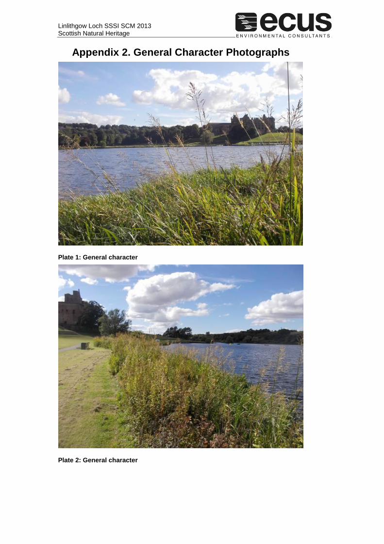
Appendix 2. General Character Photographs
Plate 1: General character
Plate 2: General character
Linlithgow Loch SSSI SCM 2013 Scottish Natural Heritage
Plate 3: Blue-green algae bloom washed up on eastern shore

Linlithgow Loch SSSI SCM 2013 Scottish Natural Heritage
Appendix 3. Water Quality Data
Table A1. Water quality data for Linlithgow Loch
Transect 3 Transect 4 Shore end Open water end Deep water (4m) Open water end Average
pH 7.78 7.84 7.37 7.58 7.64
Temperature (oC) 16.91 16.62 16.49 16.48 16.63
Conductivity 491 491 492 495 492
TDS (ppm) 246 246 246 248 247
Sal 0.27 0.27 0.27 0.27 0.27
DO (%) 106.30 107.00 71.20 96.80 95.33
DO (mg/l) 10.18 10.34 7.00 9.36 9.22
Secchi depth (m) 3 2.3 (To bottom)
Linlithgow Loch SSSI SCM 2013 Scottish Natural Heritage
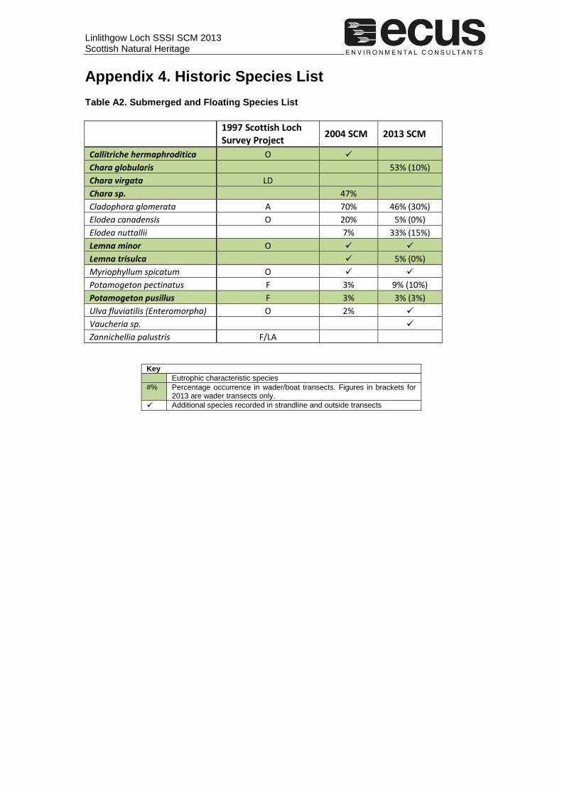
Appendix 4. Historic Species List
Table A2. Submerged and Floating Species List
1997 Scottish Loch Survey Project
2004 SCM 2013 SCM
Callitriche hermaphroditica O
Chara globularis 53% (10%)
Chara virgata LD
Chara sp. 47%
Cladophora glomerata A 70% 46% (30%)
Elodea canadensis O 20% 5% (0%)
Elodea nuttallii 7% 33% (15%)
Lemna minor O
Lemna trisulca 5% (0%)
Myriophyllum spicatum O
Potamogeton pectinatus F 3% 9% (10%)
Potamogeton pusillus F 3% 3% (3%)
Ulva fluviatilis (Enteromorpha) O 2%
Vaucheria sp.
Zannichellia palustris F/LA
Key
Eutrophic characteristic species
#% Percentage occurrence in wader/boat transects. Figures in brackets for 2013 are wader transects only.
Additional species recorded in strandline and outside transects
Linlithgow Loch SSSI SCM 2013 Scottish Natural Heritage
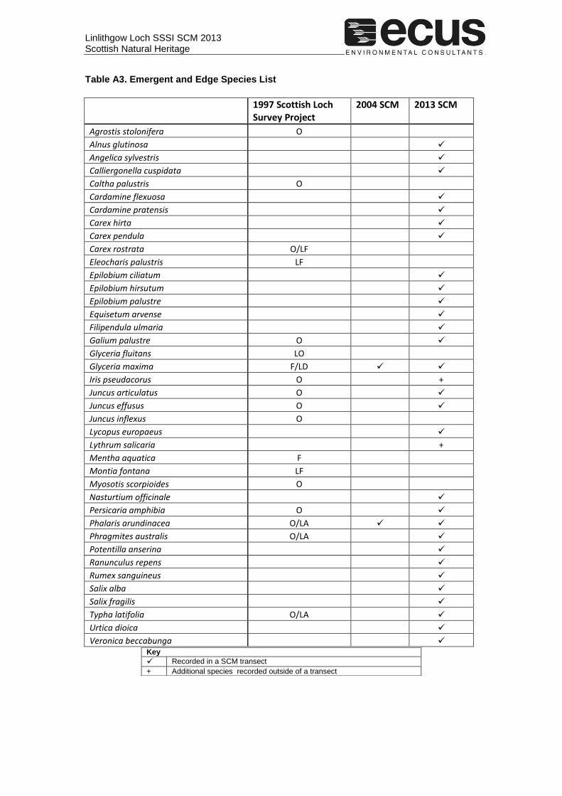
Table A3. Emergent and Edge Species List
1997 Scottish Loch Survey Project
2004 SCM 2013 SCM
Agrostis stolonifera O
Alnus glutinosa
Angelica sylvestris
Calliergonella cuspidata
Caltha palustris O
Cardamine flexuosa
Cardamine pratensis
Carex hirta
Carex pendula
Carex rostrata O/LF
Eleocharis palustris LF
Epilobium ciliatum
Epilobium hirsutum
Epilobium palustre
Equisetum arvense
Filipendula ulmaria
Galium palustre O
Glyceria fluitans LO
Glyceria maxima F/LD
Iris pseudacorus O +
Juncus articulatus O
Juncus effusus O
Juncus inflexus O
Lycopus europaeus
Lythrum salicaria +
Mentha aquatica F
Montia fontana LF
Myosotis scorpioides O
Nasturtium officinale
Persicaria amphibia O
Phalaris arundinacea O/LA
Phragmites australis O/LA
Potentilla anserina
Ranunculus repens
Rumex sanguineus
Salix alba
Salix fragilis
Typha latifolia O/LA
Urtica dioica
Veronica beccabunga
Key
Recorded in a SCM transect
+ Additional species recorded outside of a transect

Linlithgow Loch SSSI SCM 2013 Scottish Natural Heritage
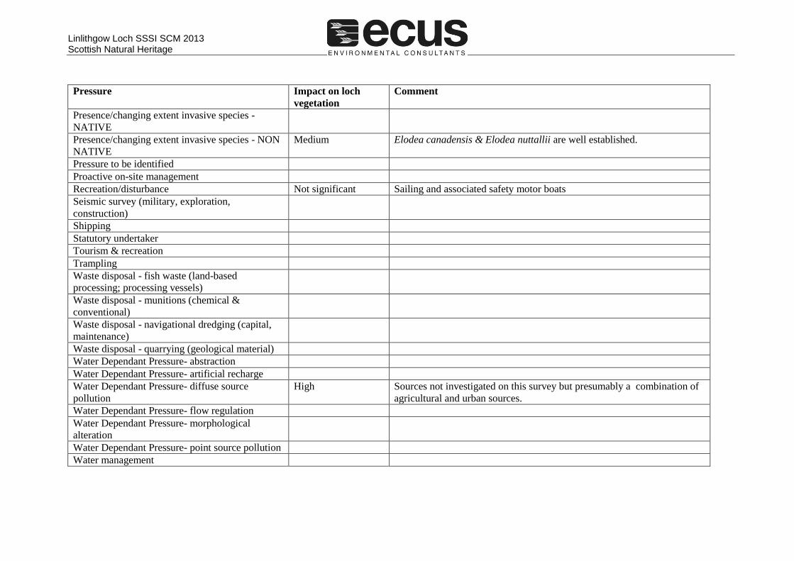
Appendix 5. Site pressures
Table A4. Site pressures affecting Linlithgow Loch
Pressure Impact on loch
vegetation
Comment
Agricultural operations Uncertain Arable fields to north may be contributing nutrients but broad buffer zone.
However, 2004 report notes that farmers plough close to inflow streams
Aquaculture - finfish
Aquaculture - shellfish
Beach replenishment
Burning
Development with planning permission
Dumping/spreading/storage of materials
Energy production - at sea (wind & wave
turbines)
Energy production - on land (power stations, inc.
nuclear)
Extraction - dredging (capital, maintenance)
Extraction - maerl
Extraction - oil & gas
Extraction - quarrying
Extraction - sand & gravel
Extraction - water (freshwater catchment;
industrial, e.g. power station)
Fishing - benthic trawling
Fishing - hydraulic dredging
Fishing - pelagic trawling
Fishing - potting/creeling
Fishing - recreational Not significant Boat fishing. 2004 report notes that the lake is stocked with rainbow trout.
Fishing - set netting

Linlithgow Loch SSSI SCM 2013 Scottish Natural Heritage
Pressure Impact on loch
vegetation
Comment
Fishing - shellfish harvesting
Flood defence/coastal defence works
Forestry operations
Game or fisheries management
Graffiti/defacing of site
Grazing - appropriate level
Grazing - over
Grazing - under
Harvesting - seaweed
Infrastructure - cables & pipelines
Infrastructure - coastal (ports, marinas, leisure
facilities)
Infrastructure - coastal defence & land claim
Infrastructure - offshore (artificial reefs)
Infrastructure - offshore (oil & gas platforms)
Infrastructure - offshore (wind turbines)
Inter-specific competition
Maintenance activities carried on site by an
organisation
Military activities
Mineral extraction
Natural event
No on-site activities related to feature condition
noted
Non intervention
Pollution - air-based sources (inc. greenhouse
gases)
Pollution - land-based sources High Water quality affected by diffuse sources.
Pollution - sewerage
Linlithgow Loch SSSI SCM 2013 Scottish Natural Heritage
Pressure Impact on loch
vegetation
Comment
Presence/changing extent invasive species -
NATIVE
Presence/changing extent invasive species - NON
NATIVE
Medium Elodea canadensis & Elodea nuttallii are well established.
Pressure to be identified
Proactive on-site management
Recreation/disturbance Not significant Sailing and associated safety motor boats
Seismic survey (military, exploration,
construction)
Shipping
Statutory undertaker
Tourism & recreation
Trampling
Waste disposal - fish waste (land-based
processing; processing vessels)
Waste disposal - munitions (chemical &
conventional)
Waste disposal - navigational dredging (capital,
maintenance)
Waste disposal - quarrying (geological material)
Water Dependant Pressure- abstraction
Water Dependant Pressure- artificial recharge
Water Dependant Pressure- diffuse source
pollution
High Sources not investigated on this survey but presumably a combination of
agricultural and urban sources.
Water Dependant Pressure- flow regulation
Water Dependant Pressure- morphological
alteration
Water Dependant Pressure- point source pollution
Water management
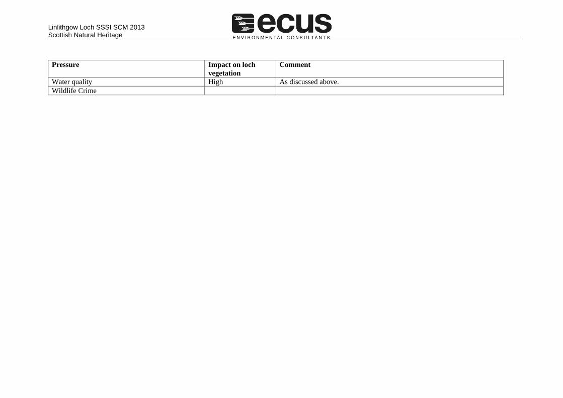
Linlithgow Loch SSSI SCM 2013 Scottish Natural Heritage
Pressure Impact on loch
vegetation
Comment
Water quality High As discussed above.
Wildlife Crime