lincoln/lancaster county planning staff report … · lincoln/lancaster county planning staff ......
TRANSCRIPT
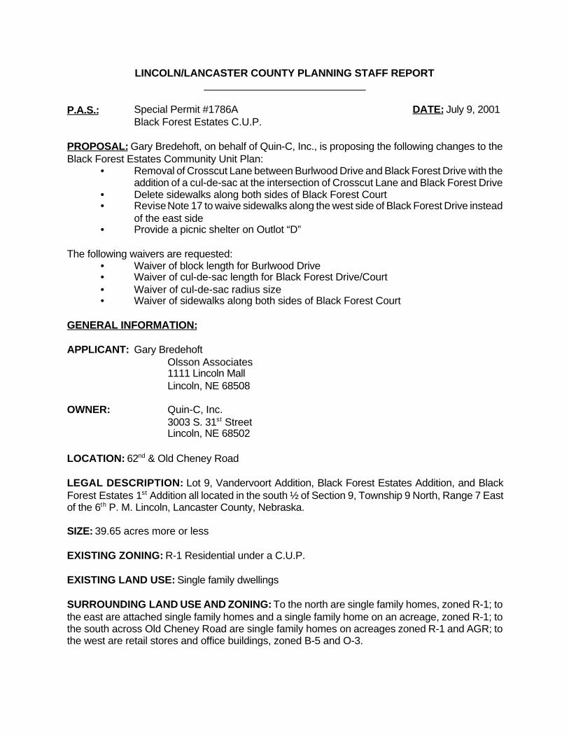
LINCOLN/LANCASTER COUNTY PLANNING STAFF REPORT
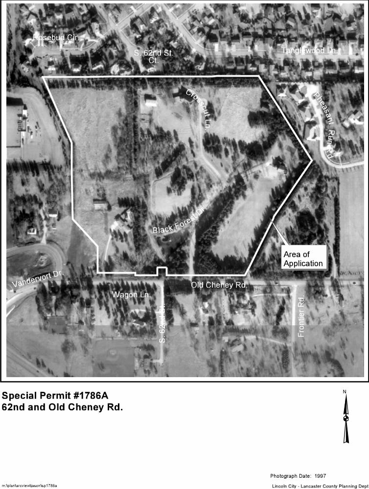
P.A.S.: Special Permit #1786A DATE: July 9, 2001 Black Forest Estates C.U.P.
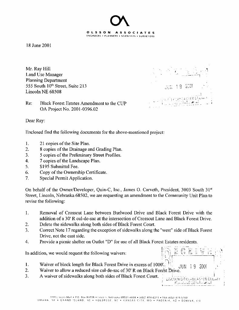
PROPOSAL: Gary Bredehoft, on behalf of Quin-C, Inc., is proposing the following changes to theBlack Forest Estates Community Unit Plan:
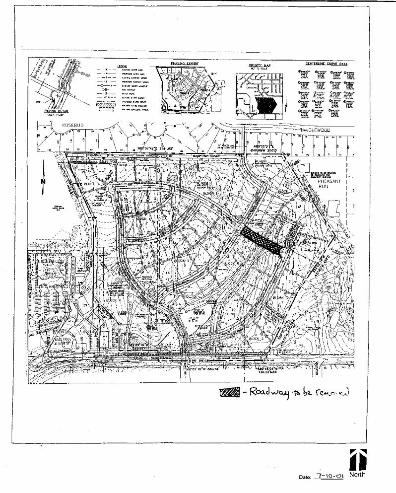
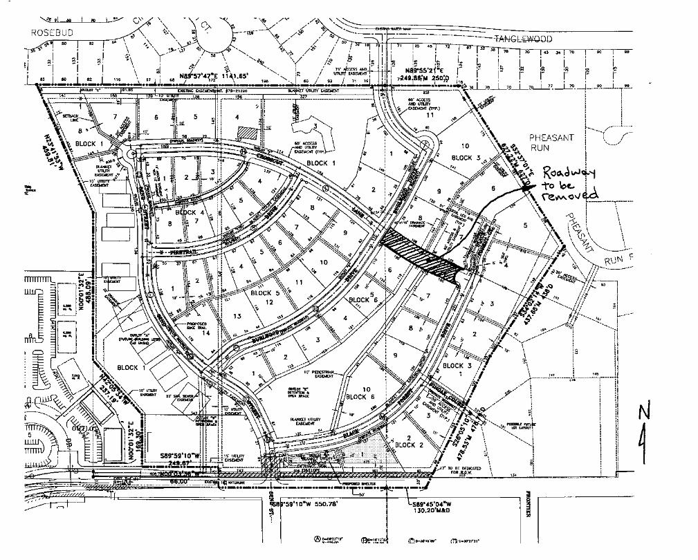
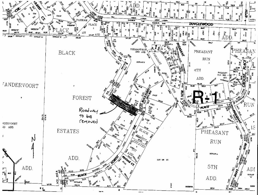
• Removal of Crosscut Lane between Burlwood Drive and Black Forest Drive with theaddition of a cul-de-sac at the intersection of Crosscut Lane and Black Forest Drive
• Delete sidewalks along both sides of Black Forest Court• Revise Note 17 to waive sidewalks along the west side of Black Forest Drive instead
of the east side• Provide a picnic shelter on Outlot “D”
The following waivers are requested:• Waiver of block length for Burlwood Drive• Waiver of cul-de-sac length for Black Forest Drive/Court• Waiver of cul-de-sac radius size• Waiver of sidewalks along both sides of Black Forest Court
GENERAL INFORMATION:
APPLICANT: Gary BredehoftOlsson Associates1111 Lincoln MallLincoln, NE 68508
OWNER: Quin-C, Inc.3003 S. 31st StreetLincoln, NE 68502
LOCATION: 62nd & Old Cheney Road
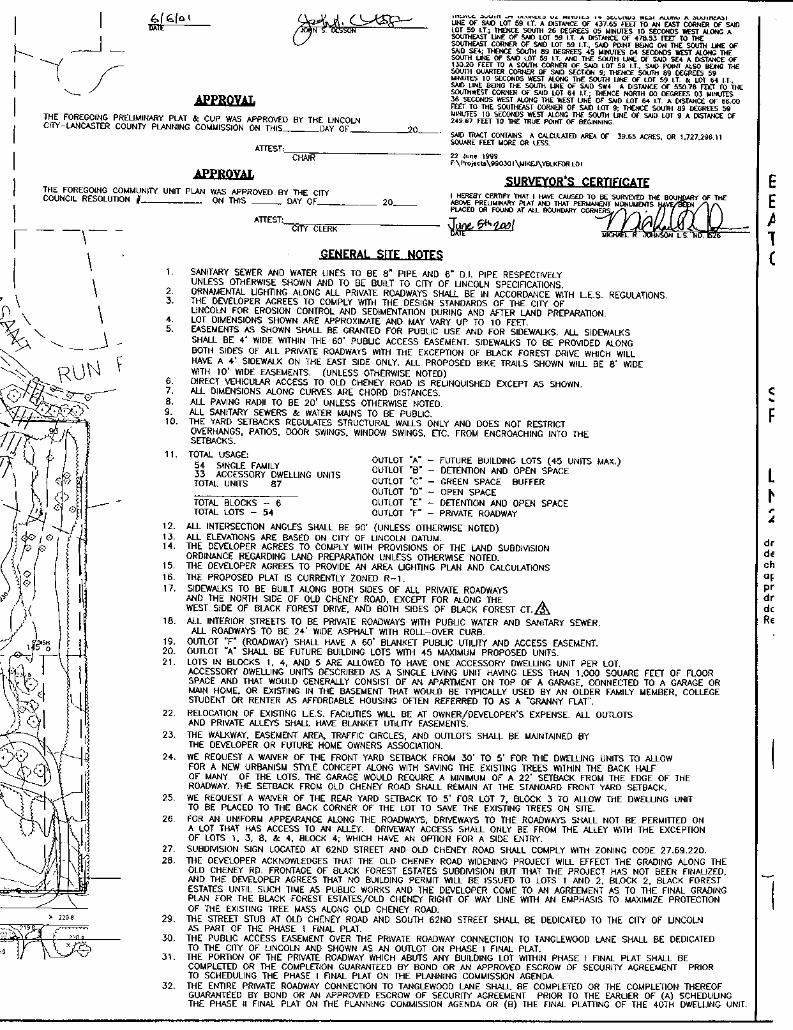
LEGAL DESCRIPTION: Lot 9, Vandervoort Addition, Black Forest Estates Addition, and BlackForest Estates 1st Addition all located in the south ½ of Section 9, Township 9 North, Range 7 Eastof the 6th P. M. Lincoln, Lancaster County, Nebraska.
SIZE: 39.65 acres more or less
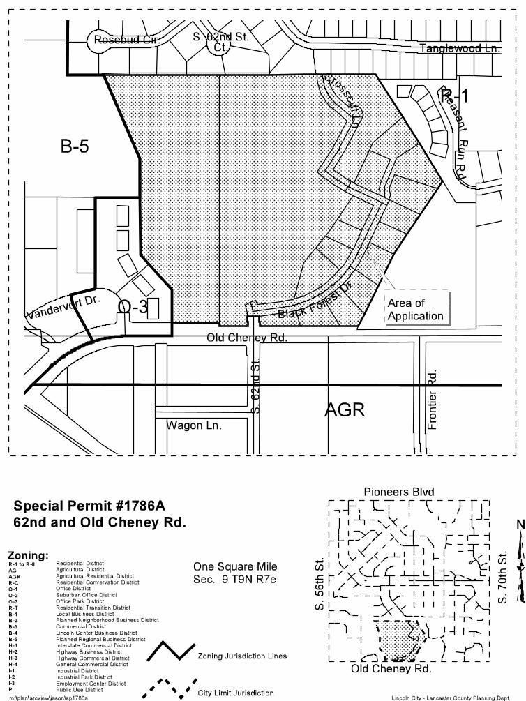
EXISTING ZONING: R-1 Residential under a C.U.P.
EXISTING LAND USE: Single family dwellings SURROUNDING LAND USE AND ZONING: To the north are single family homes, zoned R-1; tothe east are attached single family homes and a single family home on an acreage, zoned R-1; tothe south across Old Cheney Road are single family homes on acreages zoned R-1 and AGR; tothe west are retail stores and office buildings, zoned B-5 and O-3.
SP #1786A page 2
COMPREHENSIVE PLAN SPECIFICATIONS: The Land Use Plan shows the site as UrbanResidential
HISTORY: The site was converted from A-1 Single Family to R-1 Residential with the 1979 zoningupdate.
Nov. 19, 1984 City Council approved Special Permit #1114 - the Pheasant Run CommunityUnit Plan to the east. The City Council Resolution amended the site plan byremoving the road connection from Tanglewood Lane to Pheasant Lane(now called Pheasant Run Place). The plans retained a connection from S.68th Street to Grouse Place via Brushwood Lane and to the east viaTallowwood Ave.
May 4, 1987 City Council approved Special Permit #1114B, which amended the lot layoutof the Pheasant Run Community Unit Plan and removed the streetconnection to Brushwood Lane. Staff had requested that the streetconnection to Colonial Hills remain.
1988 City Council requested that staff study potential vehicular outlets fromColonial Hills to Old Cheney Road.
June 3, 1996 City Council approved Special Permit #1615, the Tallow Wood CUP, which,over a staff recommendation of denial, created a cul-de-sac east ofPheasant Run and closed off the final potential connection from PheasantRun to Hickory Crest and Colonial Hills.
Dec. 20, 1999 City Council approved the Black Forest Estates Preliminary Plat andCommunity Unit Plan, which approved a road connection to TanglewoodLane to be completed after 10 years or the construction of the 60th of 88 unitswithin Black Forest Estates.
Dec. 29, 1999 The Mayor vetoed City Council’s action, noting that the street connection toColonial Hills must be completed earlier than stipulated in the originalresolutions.
Jan. 18, 2000 City Council approved the Black Forest Estates Preliminary Plat and CommunityUnit Plan using a substitute resolution which mandated an earlier street connectionto Tanglewood Lane in Colonial Hills. The entire connection to Tanglewood Laneshall be completed or the completion thereof guaranteed by a bond or an approvedescrow of security agreement prior to the earlier of (a) scheduling the Phase II finalplat on the Planning Commission agenda or (b) the final platting of the 40th dwellingunit.
SPECIFIC INFORMATION:
UTILITIES: The area can be served with public utilities.
TOPOGRAPHY: The property generally slopes from northeast to southwest.
SP #1786A page 3
TRAFFIC ANALYSIS: The City Staff in 1988 was requested by the City Council to study vehicularoutlets from the Colonial Hills area to Old Cheney Road. Five outlets were studied. On September19, 1988, the City Council authorized the purchase of land in Parham Place. On March 9, 1992, theCity and Quin-C entered into a sales agreement. One of the stipulations states that the City shallnot construct a street stub or curb return until the development of the land owned by Quin-C.
PUBLIC SERVICE: The closest fire station is #6, located at Highway 2 and S. 48th Street. TheComprehensive Plan proposes that this station be relocated to S. 70th Street and Pioneers Blvd.
REGIONAL ISSUES: Vehicular circulation from Colonial Hills to Old Cheney Road.
ENVIRONMENTAL CONCERNS: Wetlands
AESTHETIC CONSIDERATIONS: Protection of existing trees
ANALYSIS:
1. The applicant states that the changes to the C.U.P. are an attempt to save existing trees onsite, minimize grading and changes to existing drainage courses.
2. The elimination of Crosscut Lane would save some tree mass, but the Public Works andUtilities Department notes, “The trees in the area of Crosscut Lane are... shown on thelandscape plan to be eliminated anyway. This approved street system was proposed by thedeveloper and street right-of-way and lots platted. If the goal was to save trees and minimizegrading, the lot and street layout should have been proposed differently when there wasmaximum flexibility in the design.”
3. The Public Works & Utilities Department objects to the elimination of Crosscut Lanebetween 62nd Street and Black Forest Drive. In addition to exceeding the subdivisionordinance cul-de-sac length requirements, it requires a water main to be built through anopen area with drainage that fails to meet design standards. The removal of Crosscut Lanewould also cause Burlwood Drive to exceed block length standards. A vehicle trip fromBurlwood Drive as it enters the subdivision to the end of Black Forest Court would become1/4 mile longer if Crosscut Lane were removed. The Public Works & Utilities Departmentfurther notes that there may be some flexibility in the grades of Crosscut and accompanyinggrading plan to minimize the grading necessary to construct the approved street system.
4. The sidewalks on the west side of Black Forest Drive were waived because a pedestrianeasement was provided through the center of Block 6 as a replacement. No other sidewalkswere waived in the development. The request to waive sidewalks on Black Forest Courtshould be denied.
5. The City acquired land in Colonial Hills with the intent to provide a vehicular connection fromTanglewood Lane to Old Cheney Road. Black Forest Drive and Crosscut Lane are the onlyfinal platted roadways which connect to the neighborhoods to the north. This connectionshould not be removed.
SP #1786A page 4
6. The street connections and timing in the approved C.U.P. were the result of lengthynegotiations between the City and the applicant. Both parties agreed to the conditions of theBlack Forest Estates C.U.P. and nothing has changed to warrant altering that agreement.
7. The picnic shelter can be added to the site plan through the administrative amendmentprocess.
STAFF CONCLUSION: The removal of Crosscut Lane would result in a number of deviations fromsubdivision development standards. The tract of land is neither of such an unusual size or shape,nor is it surrounded by unusual conditions such that strict application of standards would result inactual difficulties or substantial hardship or injustice. Furthermore the removal of Crosscut Lanewould eliminate the only final platted connection in Black Forest Estates from Old Cheney Road tothe Colonial Hills neighborhood. If this application were approved and the remainder of Black ForestEstates failed to develop, then the opportunity to connect Colonial Hills to Old Cheney Road wouldbe lost.
STAFF RECOMMENDATION: Denial
If, after holding a public hearing, the Planning Commission determines that this application shouldbe approved, the following conditions should apply:
CONDITIONS:
Site Specific:
1. After the applicant completes the following instructions and submits the documents and plans tothe Planning Department office and the plans are found to be acceptable, the application will bescheduled on the City Council's agenda:
1.1 Revise the site plan to show:
1.1.1 Show sidewalk in former Crosscut Lane.
1.1.2 Remove the cul-de-sac on Black Forest Drive.
1.1.3 Revise Note 17 to delete “and both sides of Black Forest Ct.” Also add notestating that sidewalks shall be constructed within pedestrian easements.
1.1.4 Revise the grading plan to the satisfaction of Public Works & Utilties.
1.1.5 Revise the Phasing Exhibit to match the previously approved Phasing.
1.1.6 In Note 11, add “and recreation facilities” to the description for Outlot “D”.
1.1.7 Revise the legal description - the C.U.P. no longer includes Lots 64 and 59I.T.
1.1.8 To Note 5 add language indicating sidewalks shall be constructed withinpedestrian easements.
SP #1786A page 5
2. This approval permits:
2.1 88 dwelling units.
2.2 Adjustment to a 5' front yard setback except along Old Cheney Road with aminimum 22' setback for garages.
2.3 Adjustment to a 5' rear yard on Lot7, Block 7.
2.4 Accessory dwelling units described as a single living unit having less than1,000 square feet of floor space and that would generally consist of anapartment on top of a garage, connected to a garage or main home, orexisting in the basement that would be typically used by an older familymember, college student or renter as affordable housing often referred to asa “granny flat”. One accessory dwelling unit may be permitted on each of thelots in Blocks 4-6.
2.5 A waiver of sidewalks on the west side of Black Forest Drive.General:
3. Before receiving building permits:
3.1 The permittee shall have submitted a revised and reproducible final plan and 5copies to the Planning Department.
3.2 The construction plans shall comply with the approved plans.
3.3 Final Plats shall be approved by the City.
STANDARD CONDITIONS:
4. The following conditions are applicable to all requests:
4.1 Before occupying the dwelling units all development and construction shall havebeen completed in compliance with the approved plans.
4.2 All privately-owned improvements shall be permanently maintained by the owner oran appropriately established homeowners association approved by the City Attorney.
4.3 The site plan accompanying this permit shall be the basis for all interpretations ofsetbacks, yards, locations of buildings, location of parking and circulation elements,and similar matters.
4.4 This resolution's terms, conditions, and requirements bind and obligate thepermittee, its successors and assigns.
SP #1786A page 6
4.5 The City Clerk shall file a copy of the resolution approving the permit and the letterof acceptance with the Register of Deeds. The Permittee shall pay the recording feein advance.
Prepared by:
________________________Jason ReynoldsPlanner
F:\FILES\Planning\PC\PERMITS\SP\1700\SP1786A.blackforestestates.jwr.wpd