lido key, city of sarasota, florida … protection/sarasota...lido key, city of sarasota, florida...
TRANSCRIPT
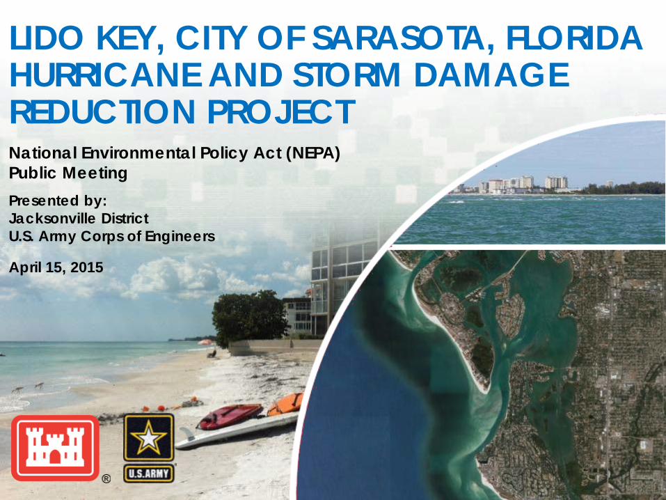
LIDO KEY, CITY OF SARASOTA, FLORIDA HURRICANE AND STORM DAMAGE REDUCTION PROJECT National Environmental Policy Act (NEPA) Public Meeting Presented by: Jacksonville District U.S. Army Corps of Engineers
April 15, 2015
2 BUILDING STRONG®
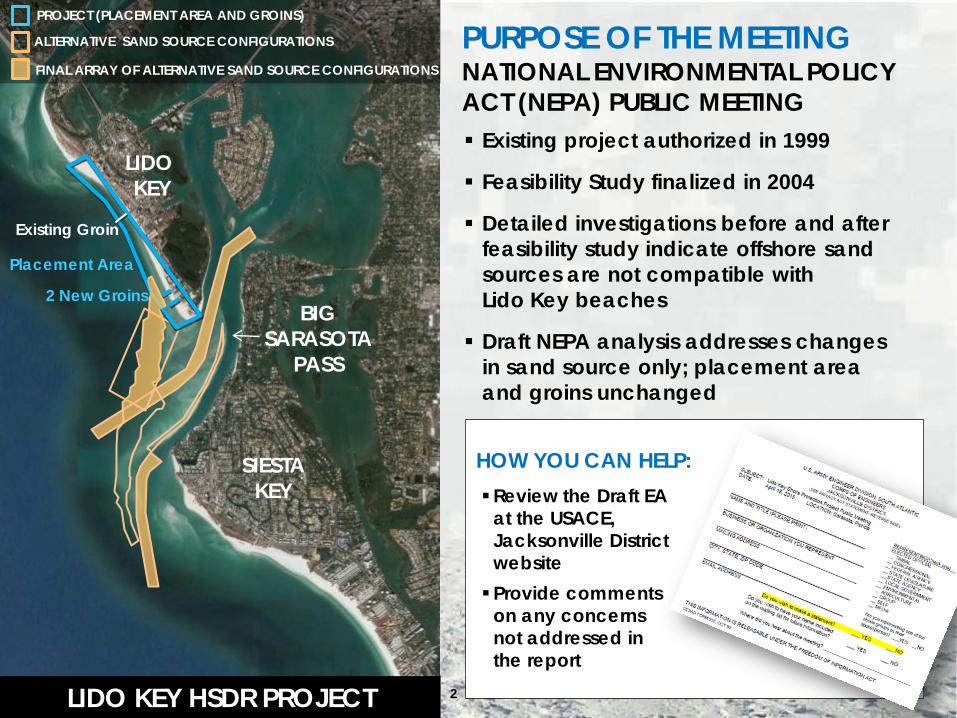
PURPOSE OF THE MEETING NATIONAL ENVIRONMENTAL POLICY ACT (NEPA) PUBLIC MEETING
Existing project authorized in 1999
Feasibility Study finalized in 2004
Detailed investigations before and after feasibility study indicate offshore sand sources are not compatible with Lido Key beaches
Draft NEPA analysis addresses changes in sand source only; placement area and groins unchanged
HOW YOU CAN HELP: Review the Draft EA
at the USACE, Jacksonville District website Provide comments
on any concerns not addressed in the report
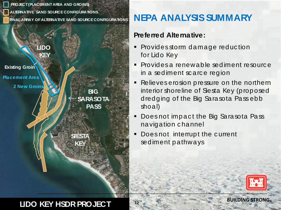
FINAL ARRAY OF ALTERNATIVE SAND SOURCE CONFIGURATIONS
LIDO KEY
Existing Groin
Placement Area
2 New Groins BIG
SARASOTA PASS
SIESTA KEY
PROJECT (PLACEMENT AREA AND GROINS)
ALTERNATIVE SAND SOURCE CONFIGURATIONS
LIDO KEY HSDR PROJECT
FINAL ARRAY OF ALTERNATIVE SAND SOURCE CONFIGURATIONS
3 BUILDING STRONG®
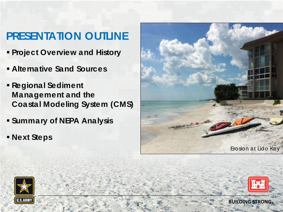
Project Overview and History
Alternative Sand Sources
Regional Sediment Management and the Coastal Modeling System (CMS)
Summary of NEPA Analysis
Next Steps
PRESENTATION OUTLINE
Erosion at Lido Key
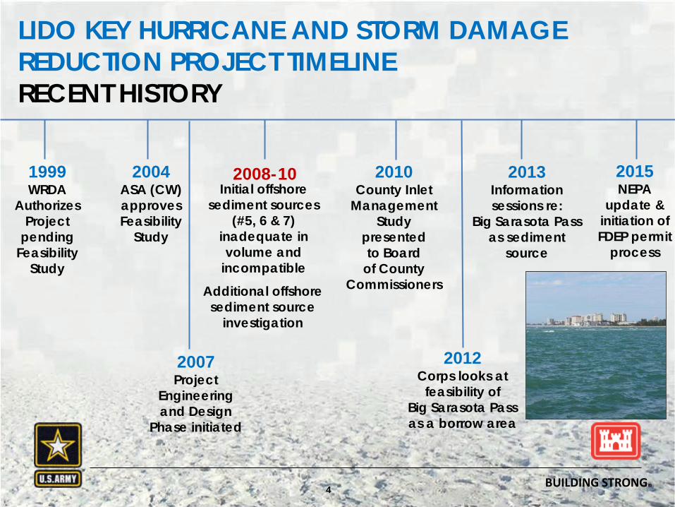
LIDO KEY HURRICANE AND STORM DAMAGE REDUCTION PROJECT TIMELINE RECENT HISTORY
4 BUILDING STRONG®
1999 WRDA
Authorizes Project
pending Feasibility
Study
2004 ASA (CW) approves Feasibility
Study
2010 County Inlet
Management Study
presented to Board
of County Commissioners
2007 Project
Engineering and Design
Phase initiated
Initial offshore sediment sources
(#5, 6 & 7) inadequate in volume and
incompatible
2008-10
2012 Corps looks at
feasibility of Big Sarasota Pass as a borrow area
2013 Information sessions re:
Big Sarasota Pass as sediment
source
2015 NEPA
update & initiation of FDEP permit
process
Additional offshore sediment source
investigation
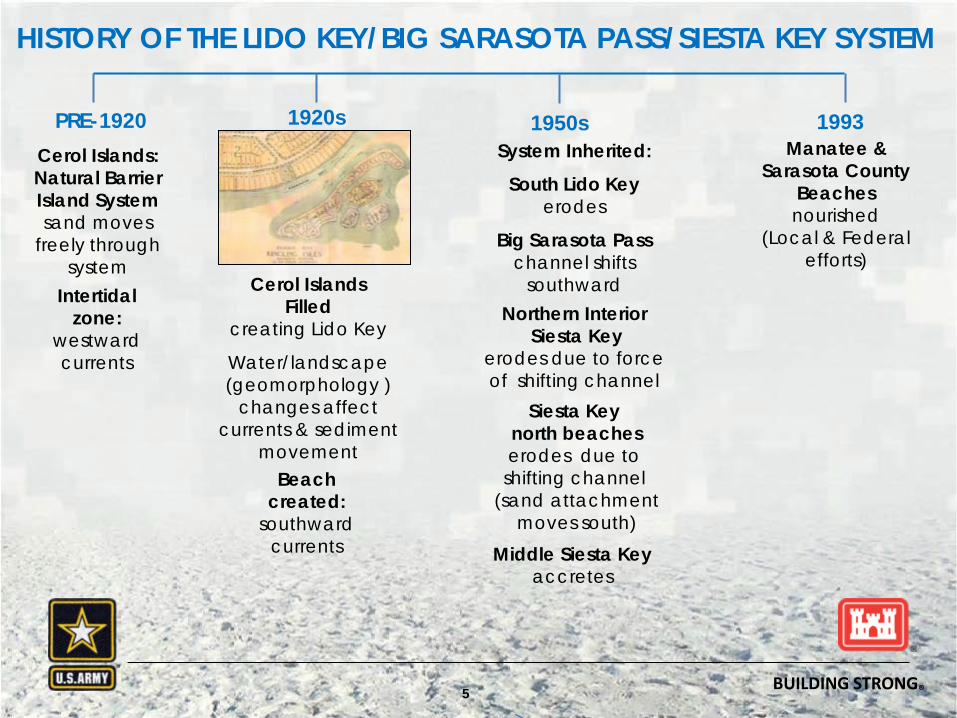
HISTORY OF THE LIDO KEY/BIG SARASOTA PASS/SIESTA KEY SYSTEM
5 BUILDING STRONG®
PRE-1920
1920s
Cerol Islands Filled
creating Lido Key
Water/landscape (geomorphology )
changes affect currents & sediment
movement
1950s System Inherited:
South Lido Key erodes
Big Sarasota Pass channel shifts
southward
Northern Interior Siesta Key
erodes due to force of shifting channel
Siesta Key north beaches erodes due to shifting channel
(sand attachment moves south)
1993 Cerol Islands:
Natural Barrier Island System sand moves
freely through system
Manatee & Sarasota County
Beaches nourished
(Local & Federal efforts)
Intertidal
zone: westward currents
Beach created:
southward currents
Middle Siesta Key accretes
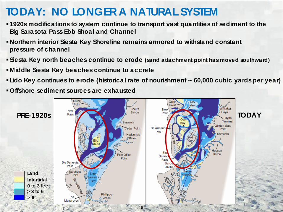
TODAY: NO LONGER A NATURAL SYSTEM 1920s modifications to system continue to transport vast quantities of sediment to the
Big Sarasota Pass Ebb Shoal and Channel Northern interior Siesta Key Shoreline remains armored to withstand constant
pressure of channel Siesta Key north beaches continue to erode (sand attachment point has moved southward)
Middle Siesta Key beaches continue to accrete Lido Key continues to erode (historical rate of nourishment ~ 60,000 cubic yards per year) Offshore sediment sources are exhausted
6
PRE-1920s TODAY
Land Intertidal 0 to 3 feet > 3 to 6 > 6

7 BUILDING STRONG®
SCARCE SAND RESOURCES There is no cost-effective sediment
offshore that is also geologically compatible
Extensive offshore sand search unsuccessful
Sediment sources identified in the Inlet Management Study and Feasibility Study includes Big Sarasota Pass ebb shoal
►Florida Department of Environmental Protection (FDEP) Sand Rule for color, grain size, shell content, silt content, etc.
►Thickness of deposit and horizontal buffers around hardbottom resources and cultural resources
Sediment Source Data by CB&I (updated by USACE 2014)
SCREENED: 2000
SCREENED: 2010
SCREENED: 2008 HIGH (SUITABLE MATERIAL)
LOW (PREVIOUSLY DREDGED)
LOW (IDENTIFIED BORROW AREA, UNSUITABLE MATERIAL)
MODERATE (MARGINAL OR UNKNOWN MATERIAL)
LOW (UNSUITABLE MATERIAL)
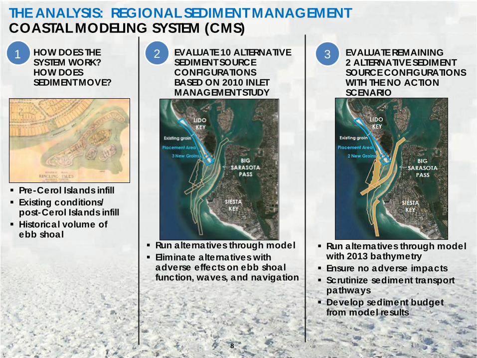
THE ANALYSIS: REGIONAL SEDIMENT MANAGEMENT COASTAL MODELING SYSTEM (CMS)
8
HOW DOES THE SYSTEM WORK? HOW DOES SEDIMENT MOVE?
1
Pre-Cerol Islands infill Existing conditions/
post-Cerol Islands infill Historical volume of
ebb shoal
2
Run alternatives through model Eliminate alternatives with
adverse effects on ebb shoal function, waves, and navigation
EVALUATE 10 ALTERNATIVE SEDIMENT SOURCE CONFIGURATIONS BASED ON 2010 INLET MANAGEMENT STUDY
3 EVALUATE REMAINING 2 ALTERNATIVE SEDIMENT SOURCE CONFIGURATIONS WITH THE NO ACTION SCENARIO
Run alternatives through model with 2013 bathymetry
Ensure no adverse impacts Scrutinize sediment transport
pathways Develop sediment budget
from model results

BUILDING STRONG®
EXISTING VS. NEW GROINS
FORMER GROIN DESIGN
NEW GROIN DESIGN
BEACH TEMPLATE
NATIONAL ENVIRONMENTAL POLICY ACT (NEPA) Federal agencies must prepare an analysis of their actions to
assess the affect of the action on the human environment.
Based on the significance of the identified impacts, either an Environmental Assessment (EA) or an Environmental Impact Statement (EIS) is prepared.
NEPA regulations* define significance based on two criteria: Context and Intensity.
The Context is the affected environment in which an action would occur (e.g., society as a whole, a particular region, or specific affected interests).
BUILDING STRONG® 10
* Adopted by the President’s Council on Environmental Quality (CEQ)
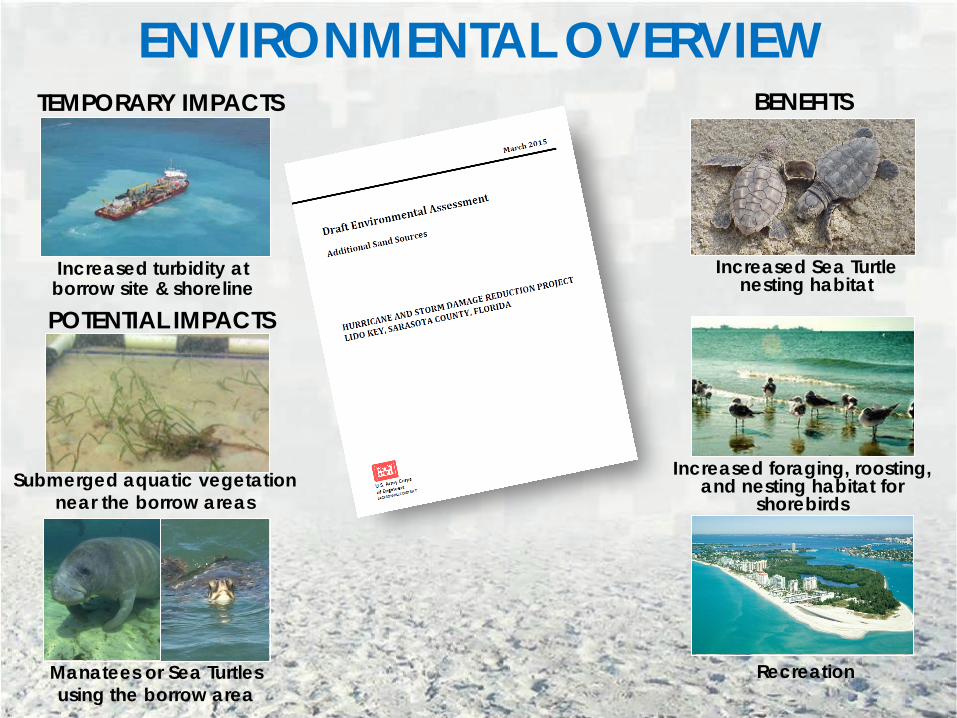
ENVIRONMENTAL OVERVIEW
Submerged aquatic vegetation near the borrow areas
POTENTIAL IMPACTS
TEMPORARY IMPACTS BENEFITS
Increased turbidity at borrow site & shoreline
Manatees or Sea Turtles using the borrow area
Recreation
Increased foraging, roosting, and nesting habitat for
shorebirds
Increased Sea Turtle nesting habitat
LIDO KEY
Existing Groin
Placement Area
2 New Groins BIG
SARASOTA PASS
SIESTA KEY
PROJECT (PLACEMENT AREA AND GROINS)
ALTERNATIVE SAND SOURCE CONFIGURATIONS
LIDO KEY HSDR PROJECT 12 BUILDING STRONG®
Preferred Alternative:
Provides storm damage reduction for Lido Key
Provides a renewable sediment resource in a sediment scarce region
Relieves erosion pressure on the northern interior shoreline of Siesta Key (proposed dredging of the Big Sarasota Pass ebb shoal)
Does not impact the Big Sarasota Pass navigation channel
Does not interrupt the current sediment pathways
NEPA ANALYSIS SUMMARY FINAL ARRAY OF ALTERNATIVE SAND SOURCE CONFIGURATIONS
13 BUILDING STRONG®
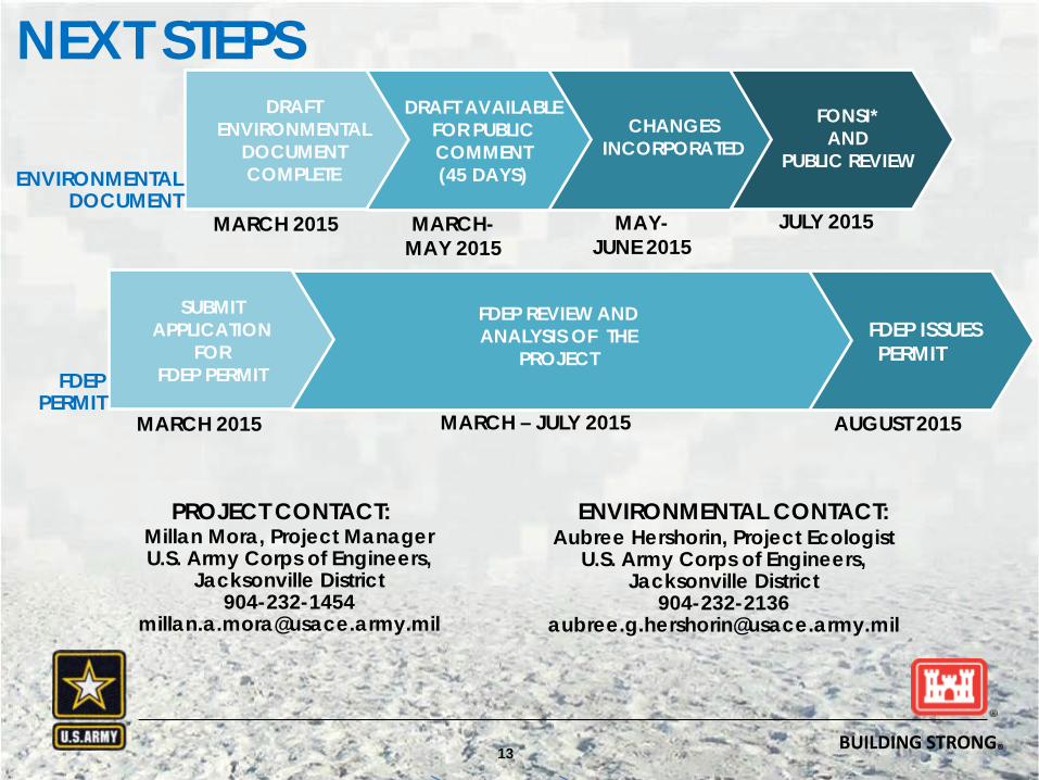
NEXT STEPS
PROJECT CONTACT: Millan Mora, Project Manager U.S. Army Corps of Engineers,
Jacksonville District 904-232-1454
ENVIRONMENTAL CONTACT: Aubree Hershorin, Project Ecologist
U.S. Army Corps of Engineers, Jacksonville District
904-232-2136 [email protected]
FDEP ISSUES PERMIT
SUBMIT APPLICATION
FOR FDEP PERMIT
DRAFT AVAILABLE FOR PUBLIC COMMENT (45 DAYS)
CHANGES INCORPORATED
FONSI* AND
PUBLIC REVIEW
DRAFT ENVIRONMENTAL
DOCUMENT COMPLETE
MARCH 2015 MARCH- MAY 2015
MAY- JUNE 2015
JULY 2015
MARCH 2015 MARCH – JULY 2015
FDEP REVIEW AND ANALYSIS OF THE
PROJECT
AUGUST 2015
ENVIRONMENTAL DOCUMENT
FDEP PERMIT