lethbridge structure plan - golden plains shire council structure plan review 2 contents 1....
TRANSCRIPT

Lethbridge Structure Plan
December 2010

LETHBRIDGE STRUCTURE PLAN REVIEW 2
Contents
1. Introduction 3
2. The Structure Plan – Function, Objectives and Implementation 4
3. Community and Stakeholder Engagement 6 Community Objectives 6
4. Lethbridge Regional Role 7
5. Lethbridge Local Context 9 Community Profile 9 Heritage 9 Land Tenure 9 Topography, Natural and Landscape Features 11 Activities and Land Use 11 Enterprise, Retail and Business Activity 11 Health and Well-Being Facilities 12 Open Space 12 Civic, Recreation, Cultural and Education Facilities 12 Housing 13 Movement and Transport 14 Urban and Built Form 15 Infrastructure 16
6. The Vision 17
7. Planning for Lethbridge’s Future – Strategic Response 18 Activities and Land Use – Residential Land 19 Landscape and Topography 20 Urban and Built Form 21 Enterprise, Retail and Business Activity 21 Civic, Recreation, Cultural and Education Facilities 22 Movement and Transport 23
8. The Structure Plan 24
9. Implementation 26 10. Monitoring and Review 28

LETHBRIDGE STRUCTURE PLAN REVIEW 3
1 Introduction
Nestled atop of the Moorabool Valley and stretching across the Midland Highway to the Geelong-Ballarat Railway line, Lethbridge offers an alternative to the suburban lifestyle. It is located only 6km north of Bannockburn and 25 minutes from Geelong. Surrounded by rural land, the town’s centre lies off the Midland Highway and its focal points extend across a star shape from the General Store, Railway Station, Primary School, Recreation Reserve and Public Hall with Bruce’s Creek running through the centre of town. The town is growing at a rate of 13 new dwellings per year. There is currently a 7 year supply of residential land within zoned areas of the township. Growth of the town relies on infill and subdivision of existing lots. There is currently very little land strategically identified for future growth of the township. It is therefore necessary to identify areas to cater for future growth over the next 10-20 years. The study area for the Lethbridge Structure Plan review is shown on the map below.

LETHBRIDGE STRUCTURE PLAN REVIEW 4
2
The Structure Plan
– Function
– Objectives
– Implementation
Function The purpose and function of the Lethbridge Structure Plan is to provide a strategic framework and establish a basis for future land use planning decisions. The Structure plan indicates a preferred layout of residential, commercial, community and other land uses based on a ten to twenty year outlook. Council has prepared the Lethbridge Structure Plan with input and assistance from community and business groups as well as individuals and government. A Steering Committee oversighted the plan development. The Structure Plan embodies the objectives of Ready for Tomorrow – A Blueprint for Regional and Rural Victoria and also supports the objectives of the Municipal Strategic Statement (MSS). Key outputs of the plan include:
A physical vision for the town for the next 10-20 years.
Strategies to guide change that reflect community values and aspirations for the growth of Lethbridge.
A set of actions to deliver the strategies.
Integration of the town’s assets and unique qualities into the vision to enhance the appearance, useability and liveability of Lethbridge.
Objectives The Plan defines the specific policy and objectives for the future of the area, and identifies opportunities and strategies to realise those objectives. The town boundary reflects the need to accommodate the projected growth and change for a 15-20 year period.

LETHBRIDGE STRUCTURE PLAN REVIEW 5
Implementation The implementation program outlines the priorities, actions and processes required to make the Structure Plan happen. The actions include amendments to the local planning policy framework and zoning controls within the township. The Structure Plan is informed by a comprehensive background report drawn from the following documents:
The Council Plan 2010-2014
State Planning Policy Framework
Melbourne 2030 and Melbourne @ 5 Million
Council’s Municipal Strategic Statement
Lethbridge Structure Plan, 1996
Lethbridge Community Plan 2010
Developing Suitable Areas for Intensive Agricultural Industries in the Golden Plains Shire, October 2004
Golden Plains Economic Development Strategy, 2007
Golden Plains Shire Recreation Strategy Plan 2008-2012
Open Space Strategy 2006
Youth Development Strategy and Action Plan 2009
Golden Plains Shire – Municipal Early Years Plan 2009-2012
Healthy People – Healthy Places – Golden Plains Shire’s Municipal Public Health Plan 2008-2012
Maternal and Child Health Service Review and Action Plan 2007-2010
Transport Plan – Golden Connections 2009-2010
Golden Plains Heritage Study Stage 2
2001 and 2006 Census data Copies of these studies and information are available upon request. Most are available on the Council website.

LETHBRIDGE STRUCTURE PLAN REVIEW 6
3 Community
and Stakeholder
Engagement
.
Consultation for the Lethbridge Town Structure Plan was undertaken in partnership with Council’s community development team with a view to revising the Community Plan as well as the Town Structure Plan. Council engaged with the community during a drop in style workshop at the Recreation Reserve with residents and community members on the 10
th March 2010.
A number of themes emerged from the consultation including: Connectivity – using walking paths to link historical bridges and features throughout the town including the Lake, the new school site and along Bruce’s Creek. Character – retaining the country character of Lethbridge with larger lot sizes (1-2 acre lots) and not becoming ‘suburban’ by keeping the open spaces and the rural living aspect the open spaces creates. A local association with surrounding bluestone quarries is a source of pride and remaining bluestone structures add to the character of the town. History – presentation of the historical elements in Lethbridge, including the identification, re-use and promotion of bluestone buildings and structures; other ideas included a tribute to the story of Peter Lalor taking cover in Letbhridge; and an interpretive feature on the history of soldier settlement in the area. Community/ Commercial Activity - the shop and recreation reserve are vital hubs for the community. Their success is important to the overall well-being of the town. Growth in the town is necessary to ensure the ongoing success of these activities. The community have worked together to achieve a number of outcomes in the town, including development of the Lake and the Recreation Reserve. Ongoing community involvement is important for the continued maintenance and development of these facilities. Bruce’s Creek – the siting of the school and the recreation reserve creates opportunities for the community to be involved in the enhancement of Bruce’s Creek. Development of the creek needs to be mindful of the 60 metre setback required under the Septic Tank Code of Practice. Residential Growth – options for growth of the town were identified towards the eastern side of the Midland Highway and around the new school site. Buffers from intensive animal industries to the north, north west and south west provide a definitive line for extension of the town in these directions. Mixed opinions were expressed regarding further subdivision of the low density residential zone in the northern areas of the town. Infrastructure – acknowledgement that reticulated sewerage is likely and will improve environmental health issues in the town. There is concern however that with sewerage comes a change in the development pattern of the town, with opportunities for smaller lots, higher densities and a more ‘suburban’ character. It was suggested that given reticulated sewerage is likely in the future, that subdivision design and siting of dwellings take into account future servicing of the town with sewerage.

LETHBRIDGE STRUCTURE PLAN REVIEW 7
4
Lethbridge
Regional Role
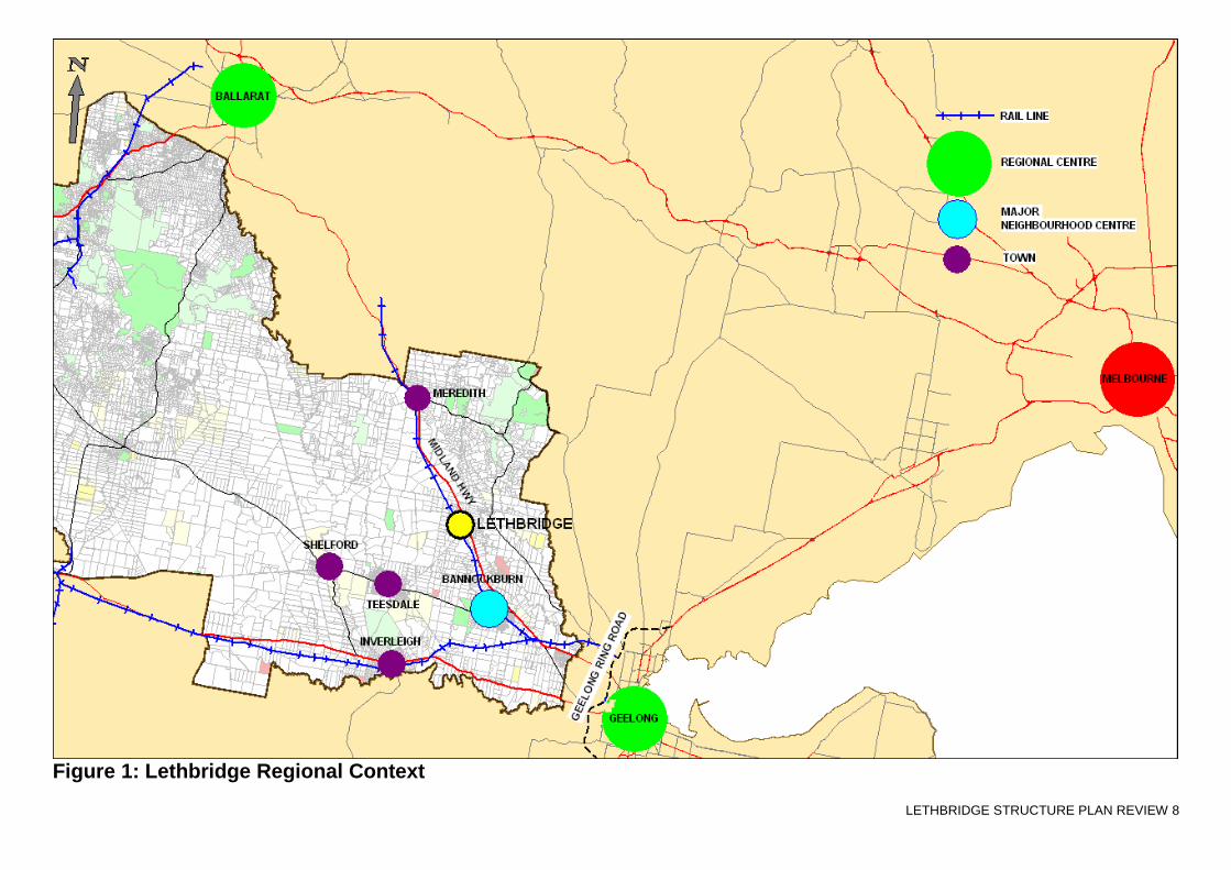
Lethbridge is a small town of approximately 900 people on the western fringe of the Geelong growth corridor. Like Teesdale and Inverleigh, Lethbridge provides an alternative ‘country-town’ lifestyle in commuter distance to Geelong. Although only 6km north of Bannockburn, the capacity for Lethbridge to grow at the rate of Bannockburn is compromised by the lack of reticulated sewerage. Nevertheless, there is capacity for Lethbridge to grow at a steady rate as a country town to support a community of 1500 people with around 260 additional dwellings over the next 10-20 years. Within the western growth corridor of Geelong, Bannockburn will remain the principal township for strong residential growth, providing for an increase of 6000 people over the next 20-30 years. It is predicted that Lethbridge on the other hand, will provide for an additional 400 people over the next 10 years. Factors that may change the population forecasts include the availability of reticulated sewerage and the potential for passenger rail services on the existing railway line linking Lethbridge to Geelong and Ballarat. Housing affordability is also a potential driver for accelerated-growth in the town. The town supports a number of industries within its hinterland, including intensive animal farming such as poultry and egg production as well as viticulture and wine production. Opportunities exist in and around the township for value adding businesses supporting these industries, including food and beverage, stockfeed, accommodation and other tourism related enterprises.
LETHBRIDGE STRUCTURE PLAN REVIEW 8
Figure 1: Lethbridge Regional Context

LETHBRIDGE STRUCTURE PLAN REVIEW 9
5
Lethbridge
Local Context
Community Profile At the 2006 census, the population of Lethbridge was 892. Half (50%) of this population is of working age (15-65 years). The population comprises 9% aged over 65 years, 24% are children younger than 15 years and a further 11% are aged 15-24 years. Family households comprise 83% of all households, half of the families have children, half do not. Lone person households comprise 13% of total households. Over half the houses are being purchased (52%) with 42% owned outright.
Land Tenure Lot sizes vary within the township area, many of the small parcels cannot be developed individually due to the lack of reticulated sewerage. There remains some larger land holdings within the township zone, providing potential infill opportunities. A key site is located adjacent to the new school site. It is estimated that there is a 7 year supply of residential land available on existing land holdings within zoned residential areas of the town. The old school site on the Midland Highway has potential for redevelopment or re-use.
Heritage The township of Lethbridge is of historical significance as one of the earliest settlements established along the major trade route linking the port of Geelong to the interior of Victoria and the Ballarat Goldfields. The Railway Station is the only significant heritage building currently listed in the Planning Scheme. Bluestone from the Lethbridge quarries was used in the construction of the Lethbridge railway station. A railway reservoir was established on the upper reaches of Bruce’s Creek to form what is now the Lethbridge Lake. The reservoir and pump house was constructed to supply water for the steam engines which took on water at the Lethbridge station. A bluestone bridge was constructed in 1859 on Russell Street to provide permanent access over Bruce’s Creek. The timber shop and dwelling at the corner of Russell Street and Ackland Road dates from the early twentieth century. As part of Planning Scheme Amendment C55, a Heritage Precinct is proposed to apply to the grid around the Railway Station, either side of Russell Street, bound by Cubbitt Street to the north and Brunel to the east. The Lethbridge Railway Station is situated in the heart of the precinct. (Lethbridge Heritage Precinct Citation Report, Hermes)

LETHBRIDGE STRUCTURE PLAN REVIEW 10
Figure 2: Lethbridge – Local Context

LETHBRIDGE STRUCTURE PLAN REVIEW 11
Topography, Natural and Landscape Features Lethbridge straddles the Midland Highway and the Highway divides the topographical features of the town. To the west of the Midland Highway are the open plains, to the east, the scenic and steep Moorabool Valley. West of the Highway and running north south through the town is Bruce’s Creek. Further west again, running parallel to Bruce’s Creek and the Highway, is the Geelong-Ballarat railway line. The soil types change across the topography. East of Bruce’s Creek is heavy basalt clay with rock. To the west of Bruce’s Creek towards Woodman Road, is the lower topography, these are lighter sandier soils. West of Woodman’s Road becomes increasingly basaltic. The township comprises two formal grid patterns that are aligned to the Midland Highway and the Geelong-Ballarat railway line respectively. Most of the community and commercial facilities are located between the railway line and Bruce’s Creek. A couple of tributaries to Bruce’s Creek also lie further east of the railway line and some land adjacent to the tributaries and Bruce’s Creek are subject to the Inundation Overlay. East of the Highway is the old school site and residential settlement of a rural residential and semi rural nature extending to the ridgeline of the Moorabool Valley.
Activities and Land Use Lethbridge is a country town with a primary school, Uniting Church, Catholic Church, sports facility including 2 ovals and a tennis court, a town hall and a general store. While predominantly residential, the Township Zone provides opportunity for a range of uses. The Township Zone is appropriate for the central areas of the town because it offers residents the ability to develop their business and income locally, while adding to the range of local services available within the community.
Enterprise, Retail and Business Activity On the periphery of town are a range of rural based activities including a rural produce store, vineyards and wineries. Broad acre farming surrounds the town and within these surrounds are a number of intensive animal industries including chicken and egg production and a boar stud facility for the artificial insemination of pigs. According to the Victorian Code for Broiler Farms 2009, the nearest external edge of a new or existing broiler shed(s) should be set back at least 1000 m from the boundary of a residential zone, urban growth zone or other urban zone where housing is a primary purpose of the zone; or future residential area, shown on a plan or strategy incorporated into the planning scheme (p.27 of the Victorian Code for Broiler Farms, 2009). The Code of Practice Piggeries, Revised 1992, specifies that for a piggery with less than 500 pigs, the required buffer distance to a residential zone is 1000 metres and the buffer distance to a proclaimed township boundary is 1600 metres. A number of bluestone quarries have operated around Lethbridge, these are currently inactive. The Golden Plains Economic Development Strategy 2007, seeks to support and promote ‘Wine, Food and Heritage’ within the southern area of the Shire.

LETHBRIDGE STRUCTURE PLAN REVIEW 12
Civic, Recreation, Cultural and Education Facilities The surviving churches, primary school and the sporting clubs remain the focus of community life in Lethbridge. The town hall, opened in 1971, ‘continues to be an integral part of community life, being used for social, educational and fundraising activities’ (Barangwanath, If These Walls Could Speak 2000, p.183). The concentration of local services within an easily accessible and walkable precinct is essential in promoting a relaxed country lifestyle and a sustainable way of living. It is important to achieve the right balance between a compact and walkable circuit of facilities whilst respecting the prevailing character of the town. The new primary school located in Stephenson Street has five classrooms catering for long term projected enrolments of up to 150 students. The old bluestone primary school on the Midland Highway will be offered for sale to other State Government Departments in the first instance. If no interest is shown, the site will be offered for sale to local government and failing interest by local government will go to public auction.
Health and Well-Being Facilities Community sport and recreation is an important aspect of the Lethbridge community. The community values both active sports programs as well as walking and cycling. The continuous development of recreation both formal and informal is seen as critical for the town.
Open Space Lethbridge has two key areas of open space, being the Lethbridge Lake and the Recreation Reserve. The Lethbridge Lake is an informal recreation space with barbecue facilities and historical elements. Trails have been developed around the lake and link to other community facilities. The Recreation Reserve has 2 ovals with a significant Sporting Centre situated between and overlooking the two ovals. The Reserve also includes a tennis court. A new playground and skate facility are located close to the recreation reserve. The new school site is located adjacent to the tennis court and Recreation Reserve and is likely to add to the vivacity of the recreation reserve. The relocation of the school will make the network of trails between the Lethbridge Lake, Recreation Reserve and shop an important community link. Bruce’s Creek is a linear reserve that links the two open space areas.

LETHBRIDGE STRUCTURE PLAN REVIEW 13
Housing Based on Council’s garbage collection data, there are 249 dwellings in the study area, which is a 2km radius from the bridge over Bruce’s Creek on Russell Street. The town is growing at a rate of 13 houses per year. The 2006 census data indicates that there are 414 dwellings in the wider Lethbridge district. Of these, the majority (94%) are separate houses. The lack of reticulated sewerage restricts the development pattern to single dwellings on lots with an area of at least 2000sqm. As such, there is limited opportunity for medium density residential development. The Septic Tank Code of Practice limits new residential lots to a minimum of 1 hectare in the absence of reticulated sewerage, unless a land capability assessment demonstrates that the soil can treat and retain waste water to appropriate standards. Based on the above factors, 130 new dwellings are expected over the next 10 years, requiring at least 130 hectares of land to be available. Land capability assessments and the use of alternative effluent disposal systems, may reduce the land size required for individual lots. A number of residential precincts have emerged for future growth opportunities: 1. Development between the new school and south to 2689 (CA !A) Midland Highway. There is approximately
26 hectares in this area, currently zoned Farming Zone. The location is close to the town’s facilities, but is constrained by Bruce’s Creek requiring a 60m setback for effluent disposal and would be well suited to sewered development.
2. West towards Woodman Road and half way between Woodman and Laird Road, offers opportunity for residential development of a scale and pattern similar to that of the existing township, subject to land capability assessments and setbacks to the tributaries of Bruce’s Creek and setbacks from the Land Subject to Inundation Overlay. Sufficient buffers to farming activities in the west must be maintained.
3. East of Kelsall Street to Dillon Road, currently zoned Rural Activity Schedule 2. Alternative residential zonings may be suited to this area to provide for medium term residential growth.
4. North of Broom Road up to Quarry Road, provides opportunities for further subdivision in accordance with Council’s policy for the LDRZ. If sewerage becomes available, consideration should be given to rezoning this area to accommodate smaller lots. Rezoning of 17 (Lots 2 TP16454) and 35 (PT TPO 86) O’Connor Road and Lot 1 TP 16434 Noyes Road in the short term would provide further opportunity for LDRZ sized lots close to the town’s facilities.
5. Medium to long term, the area north of Quarry and Goggin Roads bounded by Ackland Road to the west and 2970 (CA 33) Midland Highway and 56 (Lot 4 PS 409254) Robertson Road to the north and east be included within the township and rezoned to the Low Density Residential Zone. This would form the northern most boundary of the town.

LETHBRIDGE STRUCTURE PLAN REVIEW 14
Movement and Transport Walking and cycling: Council’s Paths and Trails Strategy 2005 includes a map which details existing and proposed trails through the town. Priorities in the plan include:
Providing links within the township to community facilities;
Develop paths and trails along natural features.
Establish a network of paths and trails. The relocation of the school will require extension of the network of trails to the new school site. The community would like to see further development of paths and trails to promote and take advantage of heritage sites around the town. The existing crossing on the Midland Highway is threatened by the relocation of the school. Sustainability of the crossing relies on the number of pedestrians using the crossing. Public Transport: The Ballarat to Geelong V/Line coach service operates 7 days a week and stops at Lethbridge. Due to the limited public transport options and the long distances between towns, the majority of residents rely heavily on private vehicle use. The existence of the Geelong-Ballarat Railway Line provides the opportunity for resumption of passenger services. Cars and Parking: The road network in the township is adequate. Particular truck routes apply to some of the intensive animal industries surrounding the town, to limit impacts on local roads. VicRoads have indicated that there is sufficient provision for duplication of the Midland Highway, through Lethbridge, if traffic movements exceeded 15,000 movements per day. There are currently 4000 vehicle movements per day on the Midland Highway.

LETHBRIDGE STRUCTURE PLAN REVIEW 15
Urban and Built Form The topography of the township is relatively flat, with Bruce’s Creek meandering through the centre of the township and the Lethbridge Lake at the Recreation Reserve. The township comprises two formal grid patterns that are aligned to the Midland Highway and the Geelong-Ballarat Railway line respectively. The construction of the Geelong-Ballarat Railway line in 1858/62 dramatically reoriented the configuration of the township, re-focusing the commercial, residential and public activities in alignment with the railway line. Prior to its construction, the township was located on either side of the Midland Highway bound by Russell Street to the north and Hodges Street to the south. The township grid survives today, aligned to the road, and consists of six sections to the west and six sections to the east of the Midland Highway. A second grid of township allotments is located approximately 700 metres to the west of the Midland Highway. This grid was formally laid out following construction of the railway line. It is located on either side of the sidings, bound by Cubbitt Street to the north, Read Street to the south and Brunel Street to the west. Both Ackland Road and Noyes Road run parallel to the railway line in a north-south direction, with two sections of the grid located to the west of Noyes Road and four sections located to the east of Ackland Road. There are a number of weatherboard and timber cottages within these sections constructed in the late nineteenth and early twentieth century. A Heritage Precinct is proposed for the section of grid around the Railway Station. Within this precinct there are 19 contributory properties, as well as the Railway Station which is already protected by the Heritage Overlay. Within this precinct, attention should be paid to ensuring that development, including subdivision or consolidation, does not adversely affect the significance, character or appearance of the precinct. Restoration and conservation of the precinct should be encouraged to ensure contributory elements are maintained. Other considerations for the town, include the retention of open spaces through the town and preservation of 1-2 acre sized allotments. Wide reserves, established native trees and informal, open drains are also contributory elements to the country town character. On the western side of the Midland Highway, the design of buildings abutting the Moorabool Valley will need to be carefully managed to protect views of, from and across the Moorabool Valley.

LETHBRIDGE STRUCTURE PLAN REVIEW 16
Infrastructure Barwon Water advise that there is adequate capacity for water service of the Lethbridge area. Plans are in place to upgrade the capacity of the existing water main servicing Lethbridge from a 150mm pipe to a 300mm pipe. This upgrade is planned for completion in 2015/2016. The implementation of reticulated sewerage in Lethbridge is listed as a high priority under Council’s Domestic Waste Water Management Plan. Barwon Water is not opposed to reticulated sewerage in Lethbridge, however there are no current plans to provide Lethbridge with reticulated sewerage and funding is not available for a sewerage scheme to Lethbridge. Costs of a scheme would therefore be borne by landowners at a cost of between $20,000-30,000 per lot. Investigation into the potential to connect into the Bannockburn Sewerage Scheme should be undertaken, given that Lethbridge is only 6km north along Bruce’s Creek. Electricity is provided to all areas, with overhead powerlines along most major roads and streets. The above ground distribution network means that power supply is exposed to storm damage and third party events. There is no natural gas supplied to the town. Drainage has been raised as a concern in the community. Several roads in the town are unsealed and not drained.

LETHBRIDGE STRUCTURE PLAN REVIEW 17
6
The Vision
A vision as to how Lethbridge should be seen in 20 years time has been developed through the structure plan process. The vision reflects the aims and aspirations of the Council and the local community and can be used as a basis to guide decisions for the township.
Lethbridge will be a place where:
the appearance of the town and its assets are a source of pride and contribute to the safe and welcoming country town character.
tourism activity flourishes around themes of wine, food and heritage.
the community thrives through active living and participation in structured and unstructured recreational activities.
there are opportunities to start a business, value add and develop incomes locally.
the community is connected through participation in projects and events that build pride and enhance the liveability of the town.
there is a range of services to support the needs and well-being of all ages and sectors of the community.
environmental attributes are upgraded and enhanced and continually maintained.
an alternative and affordable country lifestyle can be enjoyed.

LETHBRIDGE STRUCTURE PLAN REVIEW 18
7
Planning for
Lethbridge’s Future - Strategic Response
Following on from the vision, the next step of the
structure planning process is to establish the objectives
(goals), strategies (approach) and actions for achieving
the vision in light of the anticipated growth.
In response to the anticipated growth, it is necessary to
identify areas for future residential development, together
with a clear boundary for the town’s growth.
The objectives, strategies and actions have been divided
into the following key themes or elements: Activities and
Land Use, Landscape and Topography, Urban and Built
Form, Civic Recreation Cultural and Education Facilities,
Movement and Transport, and Making it Happen.
LETHBRIDGE STRUCTURE PLAN REVIEW 19
Activities and Land Use
Residential Land
Objective: To provide for additional residential land to accommodate future population growth in a managed
and sustainable manner that respects the town character of Lethbridge.
Strategies
The Structure Plan aims to provide for an additional 150 lots in the short-medium term and an additional 50
lots for the longer term.
Encourage sustainable development which provides for and maintains a country town character.
Encourage Infill development within the town, where land capability assessments prove sites are suitable for
development.
Orientate new development to address natural features and community spaces, increasing opportunities for
natural surveillance and interaction with the public realm.
Provide high amenity pedestrian links connecting residential areas to Bruce’s Creek, the primary school and
central hub of the township.
Encourage social inclusiveness and safe communities where residents feel part of their local community.
Ensure new development enjoys a high level of amenity including, planting of a significant component of
canopy trees, generous nature strips and installation of sustainable urban drainage systems.
Protect residential amenity as well as the ongoing farming activities of the surrounding district.
Actions
Rezone land for residential purposes in accordance with the Lethbridge Structure Plan in Figure 4.
Provide a strong town boundary to ensure an appropriate buffer between residential and farming activities,
such as strong landscape planting and sufficient spacing between farming and residential land.
Prepare design guidelines for subdivision and residential development which anticipates future sewerage of
the town.
Pursue reticulated sewerage for the future development of the town, including investigation of the potential
to connect into the Bannockburn sewerage scheme.
Review the Lethbridge Structure Plan to consider the release of land earmarked for ‘longer term growth’ as soon as a firm commitment is made to the timing of a reticulated or alternative sewerage scheme.
Seek alternatives to formal suburban style infrastructure treatments in new subdivisions to retain the country
town character.

LETHBRIDGE STRUCTURE PLAN REVIEW 20
Landscape and Topography
Objective: Respond to the landscape and environmental qualities of the township.
Strategies:
Protect the significant views from and within the Moorabool Valley.
Protect the environmental qualities of the Moorabool Valley, Bruce’s Creek and tributaries of the Creek.
Encourage accommodation and tourism type uses to provide opportunity for the public to enjoy views of the
Moorabool Valley.
Provide areas and opportunity for public access to views of the Moorabool Valley.
Setting development limits and connecting development patterns and forms.
Signify arrival into Lethbridge by developing site specific proposals that respond to traffic movements and
introduce elements of the key urban design and landscape characteristics of Lethbridge.
Minimise intrusion of residential development into natural features, in particular the environs of Bruce’s
Creek, the Moorabool Valley and areas of native vegetation and existing stands of significant trees.
Encourage landscaping and general public realm improvements along Russell Street, Stephenson Street
and Ackland Road.
Encourage environmental improvements to Bruce’s Creek including continuing development of a path
network that connects the primary school with the recreation reserve, community and commercial precinct,
residential areas and the Lethbridge Lake.
Manage the local environment to ensure sustainable outcomes that complement both community and
conservation objectives.
Actions:
Require appropriate setbacks from the Moorabool Valley, Bruce’s Creek and tributaries of the Creek to
protect their environmental values.

LETHBRIDGE STRUCTURE PLAN REVIEW 21
Urban and Built Form
Objective: Respect the existing character,
landscape and heritage values of the town.
Strategies:
Preserve and enhance the existing character of
the town by promoting development that
responds to existing neighbourhood character
and amenity.
Preserve the distinctive characteristics of the
natural, heritage environment of Lethbridge
where possible.
Integrate new development with the existing form
and character of the town.
Actions:
Implement the Heritage Study Stage Two
Prepare design guidelines for subdivision and
residential development which anticipates future
sewerage of the town.
Require wide road reserves, landscaping with
canopy trees, space between dwellings, open
swale drains, informal infrastructure and good
pedestrian connectivity as measures to preserve
the country town character.
In consultation with the community prepare a
plan which identifies existing and planned
features of the town including entrance features,
existing historic and landscape assets, preferred
planting schemes and additional improvements
for the public realm.
Enterprise, Retail and Business Activity
Objective: Enterprise, retail and business
activity is able to establish and grow.
Strategies:
Support and promote the development of the
Wine, Food and Heritage sector in and around
the town.
Support and protect farming enterprises around
the township and encourage value adding
businesses and enterprises related to these
activities.
Actions:
Ensure zoning facilitates opportunities for new
and existing businesses.

LETHBRIDGE STRUCTURE PLAN REVIEW 22
Civic, Recreation, Cultural and Education Facilities
Objective: Civic, recreation, cultural and educational facilities will be integrated, accessible and an integral part of
community life.
Strategies:
Incorporate a range of community, civic, retail, recreation and commercial uses within the precinct where the
general store, public hall, recreation reserve and primary school are located.
Encourage access and participation in recreation, sport and leisure activities in Lethbridge.
Provide improvements to the public realm of Russell Street, Stephenson Street and Ackland Road.
Encourage social inclusiveness and safe communities by providing informal meeting spaces which reinforce the
sense of activity in this precinct and where residents can feel part of their local community.
Improve the quality and legibility of the physical and visual connections through the town and open space areas.
Optimise the use of existing public buildings and sites for the benefit of the town and community
Respect and support the development of community assets so they can be used by the community and for future
generations
Seek to fully utilise the existing facilities available within the town and when feasible continue to provide facilities to
meet community needs as the town grows.
Actions:
Continue to develop plans for the expansion of the recreation facilities with the Lethbridge Primary School.
Preserve and restore historic public buildings including the bluestone railway station and the old school.
Implement Councils Paths and Trails Strategy, Recreation Plan and Open Space Plan.
Continue to review the capacity of facilities to meet the needs of the town.

LETHBRIDGE STRUCTURE PLAN REVIEW 23
Movement and Transport
Objective: Access to all levels of transport is increasingly available.
Strategies:
Opportunities for improving all levels of transport are encouraged.
‘Walkability’ throughout the town is encouraged, rather than car dependency.
Opportunities to improve and expand modes and frequency of public transport services are pursued.
Heavy transport is discouraged from using Russell Street, with the preferred route to the western side of
Lethbridge via Lower Plains Road, Laird Road and Tall Tree Road.
Ensure vehicular traffic does not compromise a good walking and cycling environment.
Improve treatments along the Midland Highway to respond to traffic movements on the Midland Highway.
Actions:
Seek to maintain the existing pedestrian crossing across the Midland Highway.
Seek to relocate the 80km gateway zone further north of the town, to include the intersection of Ackland
Road and the Midland Highway, to avoid the crest and double line features.
Seek duplication of the Midland Highway as traffic numbers increase.
Consider creation of service roads along the Midland Highway
Seek limiting speed limits to 50km within the town.
Require heavy vehicles to avoid Russell Street when considering planning applications.

LETHBRIDGE STRUCTURE PLAN REVIEW 24
8
The Structure Plan
Framework The Structure Plan identifies precincts (or sub areas) for rezoning to provide for additional residential land. The objectives, strategies, and implementation plan for each key element or theme informs the Structure Plan and guides decision making for the future development of Lethbridge.

LETHBRIDGE STRUCTURE PLAN REVIEW 25
Figure 4: Lethbridge Structure Plan

LETHBRIDGE STRUCTURE PLAN REVIEW 26
9
Implementation
‘Making it Happen’
Making it Happen
1. Amend the Golden Plains Planning Scheme to replace the Lethbridge Structure plan with the new Structure Plan as shown in Figure 4.
2. Rezone land to the east of Weston Street, Kelsall Street and the Midland Highway to Dillon Road including 97 (Lot 1 PS 304654) Smith Road from the Rural Activity Zone to the Low Density Residential Zone, as shown in Figure 4.
3. Rezone land to the east of Woodman Road and north of Tall Tree
Road from Farming Zone to the Township Zone, as identified in Figure 4.
4. Rezone land between the new school site to the southern town
boundary from Farming Zone to Township Zone, as identified in Figure 4.
5. Prepare design guidelines for subdivision and residential
development which anticipates future sewerage of the town. 6. Rezone 17 (Lot 2 TP 16454) and 35 (PT POR 86) O’Connor Road
and Lot 1 TP 16434 Noyes Road from Farming Zone to the Low Density Residential Zone.
7. Implement the Lethbridge Heritage Precinct. 8. In consultation with the community prepare a plan which identifies
existing and planned features of the town including entrance features, existing historic and landscape assets, preferred planting schemes and additional improvements for the public realm.
9. Review the Lethbridge Structure Plan to consider the release of
land earmarked for ‘longer term growth’ as soon as a firm commitment is made to the timing of a reticulated or alternative sewerage scheme.

LETHBRIDGE STRUCTURE PLAN REVIEW 27
Note: Actions, 1, 2, 3, 4, 5 and 6 should be undertaken as a single amendment which will bring cost efficiencies.
Action
Commence
Duration
Lead Agency And Responsible Project Manager
Involved
Stakeholder & Community Engagement
Cost
Priority
1. Amend the Golden Plains Planning
Scheme to replace the Lethbridge Structure plan with the new Structure Plan, as shown in Figure 4
2011
8-12 months Golden Plains Shire Officers and DPCD
Formal amendment process
$10k 1
2. Rezone land to the east of Weston Street,
Kelsall Street and the Midland Highway to Dillon Road including 97 (Lot 1 PS 304654) Smith Road from the Rural Activity Zone to the Low Density Residential Zone..
2011 8-12 months Golden Plains Shire landholders Formal amendment process
$5k 2
3. Rezone land to the east of Woodman
Road and north of Tall Tree Road from Farming Zone to the Township Zone.
2011 8-12 months Golden Plains Shire landholders Formal amendment process
$5k 1
4. Rezone land between the new school
site to the southern town boundary from Farming Zone to Township Zone.
2011 8-12 months Golden Plains Shire landholders Formal amendment process
$5k 1
5. Prepare design guidelines for subdivision
and residential development which anticipates future sewerage of the town
2011 3 months Golden Plains Shire Urban design consultants
Formal amendment process
$5k 1
6. Rezone 17 (Lot 2 TP 16454) and 35 (PT
POR 86) O’Connor Road and Lot 1 TP 16434 Noyes Road from Farming Zone to the Low Density Residential Zone.
2011 3 months Golden Plains Shire Urban design consultants
Formal amendment process
$5k 2
7. Implement the Lethbridge Heritage
Precinct 2010 Due for
completion in 2010
Golden Plains Shire Formal amendment process
Part of existing budget
Underway
8. In consultation with the community
prepare a plan which identifies existing and planned features of the town including entrance features, existing historic and landscape assets, preferred planting schemes and additional improvements for the public realm
2011-2012 8 months Seek grant funding Community Golden Plains Shire Funding agency Consultants
Yes $10k 2
9. Review the Lethbridge Structure Plan to
consider the release of land earmarked for ‘longer term growth’ as soon as a firm commitment is made to the timing of a reticulated or alternative sewerage scheme.
When required Unknown Golden Plains Shire Community Golden Plains Shire
Yes Unknown When required

LETHBRIDGE STRUCTURE PLAN REVIEW 28
10
Monitoring and
Review
Council regularly undertakes a review of the residential land supply across the Shire to determine the timing for Structure Plan reviews.