les appellations d’origine appellations of origin las ... · les appellations d’origine...
TRANSCRIPT
Les appellations d’origineAppellations of origin
Las denominaciones de origen
No 45Janvier 2017 / January 2017 / Enero de 2017
Publication Date: February 10, 2005
Fecha de publicación: 10 de febrero de 2005
Nos 838979 - 839219
Les appellations d’origine
Publication du Bureau internationalde l’Organisation Mondiale de laPropriété IntellectuelleNo 39 - Janvier 2011
Appellations of origin
Publication of the International Bureauof the World Intellectual PropertyOrganizationNo. 39 - January 2011
Las denominaciones de origen
Publicación de la Oficina Internacionalde la Organización Mundial de laPropiedad IntelectualNo 39 - Enero de 2011
ISSN 0253-8180O OMPI 2011 PUB: 105
Janvier 2017 / January 2017 / Enero de 2017 No. 45
Les appellations d’origine Publication du Bureau international de l’Organisation Mondiale de la Propriété Intellectuelle (OMPI)
Appellations of origin Publication of the International Bureau of the World Intellectual Property Organization (WIPO)
Las denominaciones de origen Publicación de la Oficina Internacional de la Organización Mundial de la Propiedad Intelectual (OMPI)
Administration : Service d’enregistrement Lisbonne ORGANISATION MONDIALE DE LA PROPRIÉTÉ INTELLECTUELLE (OMPI) 34, chemin des Colombettes CH-1211 GENÈVE 20 (Suisse) � (+41) 22 338 91 11 Télécopieur : (+41) 22 338 84 10 Messagerie électronique : [email protected] Internet : http://www.ompi.int/lisbon
ISSN 2226-6399 OMPI 2017
Administration: Lisbon Registry WORLD INTELLECTUAL PROPERTY ORGANIZATION (WIPO) 34, chemin des Colombettes CH-1211 GENEVA 20 (Switzerland) � (+41) 22 338 91 11 Fax: (+41) 22 338 84 10 Electronic mail: [email protected] Internet: http://www.wipo.int/lisbon
ISSN 2226-6399 WIPO 2017
Administración: Registro de Lisboa ORGANIZACIÓN MUNDIAL DE LA PROPIEDAD INTELECTUAL (OMPI) 34 chemin des Colombettes CH-1211 GINEBRA 20 (Suiza) � (+41) 22 338 91 11 Fax: (+41) 22 338 84 10 Correo-E: [email protected] Internet: http://www.ompi.int/lisbon
ISSN 2226-6399 OMPI 2017
3
LES APPELLATIONS D’ORIGINE — APPELLATIONS OF ORIGIN — LAS DENOMINACIONES DE ORIGEN
JANVIER 2017 — JANUARY 2017 — ENERO DE 2017
Sommaire / Contents / Índice Page / Page / Página
Remarques relatives à la publication du bulletin Les appellations d’origine, Liste des pays membres de l’Arrangement de Lisbonne / Comments relating to the publication of the Bulletin Appellations of origin, List of Member Countries of the Lisbon Agreement / Observaciones relativas a la publicación del Boletín Las denominaciones de origen, Lista de Países Miembros del Arreglo de Lisboa ................................................................................ 4
Enregistrements / Registrations / Registros: ....................................................................................... 11 Déclarations de refus (total ou partiel) concernant l’enregistrement / Declarations of (total or partial) refusal concerning registration / Declaraciones de denegación (totales o parciales) con respecto al registro ....................................... 167
Retraits d’une déclarations de refus (retrait total ou partiel) / Withdrawals of a declarations of refusal (total or partial withdrawal) / Retiros de une declaración de denegación (retiro total o parcial) ....................................................... 191
Déclarations d’octroi de la protection / Statements of grant of protection / Declaraciones de concesión de la protección ..................................................................................... 197
Rectifications / Corrections / Correcciones ....................................................................................................................................... 201
Statistiques / Statistics / Estadísticas .................................................................................................. 205
1. Enregistrements et radiations / Registrations and cancellations / Registros y cancelaciones ............................................................................................................ 206
2. Enregistrements en vigueur (par pays d’origine) / Registrations in force (by country of origin) / Registros en vigor (por país de origen) ........................................................................................ 208
3. Refus et retraits de refus (par numéro d’enregistrement et par pays) / Refusals and withdrawals of a refusal (by registration number and by country) / Denegaciones y retiros de una denegación (por número de registro y por país) ......................... 210
4. Octrois de la protection (par numéro d’enregistrement et par pays) / Grants of protection (by registration number and by country) / Concesiones de protección (por número de registro y por país) .................................................. 228
5. Invalidations (par numéro d’enregistrement et par pays) / Invalidations (by registration number and by country) / Invalidaciones (por número de registro y por país) ..................................................................... 231
6. Motifs de refus (par numéro d’enregistrement et par pays) / Grounds for refusal (by registration number and by country) / Motivos de denegación (por número de registro y por país) ...................................................... 232
7. Appellations d’origine par produit et numéro d’enregistrement / ............................................... 236
Appellations of origin by product and registration number / ...................................................... 251
Denominaciones de origen por producto y número de registro ................................................... 265
4
LES APPELLATIONS D’ORIGINE — APPELLATIONS OF ORIGIN — LAS DENOMINACIONES DE ORIGEN
JANVIER 2017 — JANUARY 2017 — ENERO DE 2017
Remarques relatives à la publication du bulletin “Les appellations d’origine”
La publication du Bulletin “Les appellations d’origine” est éditée par le Bureau international de l’Organisation Mondiale de la Propriété Intellectuelle (OMPI), en application de l’article 5, alinéa 2, de l’Arrangement de Lisbonne, du 31 octobre 1958, révisé à Stockholm le 14 juillet 1967, concernant la protection des appellations d’origine et leur enregistrement international, ainsi que de la règle 18 du règlement d’exécution dudit Arrangement (texte en vigueur le 1er janvier 2016).
Chaque numéro peut comprendre, notamment, l’une ou l’autre des rubriques suivantes, dont la matière est groupée selon les numéros d’enregistrement et les dates d’enregistrement :
– Enregistrements – Déclarations de refus (total ou partiel*) – Retraits d’une déclaration de refus (retrait total ou partiel*) – Déclarations d’octroi de la protection – Octrois de délai d’utilisation pour terminer l’utilisation d’une
appellation d’origine – Invalidations – Modifications – Renonciations – Radiations – Rectifications
Seules peuvent être enregistrées auprès de l’OMPI, et protégées selon les
dispositions de l’Arrangement de Lisbonne, les appellations d’origine des produits de pays de l’Union de Lisbonne reconnues et protégées à ce titre dans le pays d’origine.
L’Union de Lisbonne compte 28 pays membres.
* Selon la règle 18 du règlement d’exécution, le Bureau international publie dans le Bulletin toutes les inscriptions faites
au registre international. De plus, à partir du Bulletin n° 36, le texte des refus partiels ainsi que des retraits partiels est aussi publié, dans la langue de la notification du refus ou du retrait en question.
5
LES APPELLATIONS D’ORIGINE — APPELLATIONS OF ORIGIN — LAS DENOMINACIONES DE ORIGEN
JANVIER 2017 — JANUARY 2017 — ENERO DE 2017
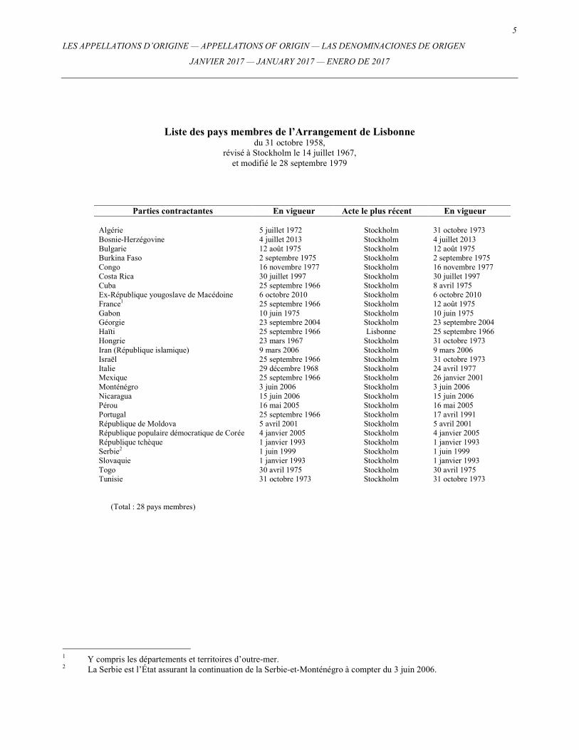
Liste des pays membres de l’Arrangement de Lisbonne du 31 octobre 1958,
révisé à Stockholm le 14 juillet 1967, et modifié le 28 septembre 1979
Parties contractantes En vigueur Acte le plus récent En vigueur Algérie 5 juillet 1972 Stockholm 31 octobre 1973 Bosnie-Herzégovine 4 juillet 2013 Stockholm 4 juillet 2013 Bulgarie 12 août 1975 Stockholm 12 août 1975 Burkina Faso 2 septembre 1975 Stockholm 2 septembre 1975 Congo 16 novembre 1977 Stockholm 16 novembre 1977 Costa Rica 30 juillet 1997 Stockholm 30 juillet 1997 Cuba 25 septembre 1966 Stockholm 8 avril 1975 Ex-République yougoslave de Macédoine 6 octobre 2010 Stockholm 6 octobre 2010 France1 25 septembre 1966 Stockholm 12 août 1975 Gabon 10 juin 1975 Stockholm 10 juin 1975 Géorgie 23 septembre 2004 Stockholm 23 septembre 2004 Haïti 25 septembre 1966 Lisbonne 25 septembre 1966 Hongrie 23 mars 1967 Stockholm 31 octobre 1973 Iran (République islamique) 9 mars 2006 Stockholm 9 mars 2006 Israël 25 septembre 1966 Stockholm 31 octobre 1973 Italie 29 décembre 1968 Stockholm 24 avril 1977 Mexique 25 septembre 1966 Stockholm 26 janvier 2001 Monténégro 3 juin 2006 Stockholm 3 juin 2006 Nicaragua 15 juin 2006 Stockholm 15 juin 2006 Pérou 16 mai 2005 Stockholm 16 mai 2005 Portugal 25 septembre 1966 Stockholm 17 avril 1991 République de Moldova 5 avril 2001 Stockholm 5 avril 2001 République populaire démocratique de Corée 4 janvier 2005 Stockholm 4 janvier 2005 République tchèque 1 janvier 1993 Stockholm 1 janvier 1993 Serbie2 1 juin 1999 Stockholm 1 juin 1999 Slovaquie 1 janvier 1993 Stockholm 1 janvier 1993 Togo 30 avril 1975 Stockholm 30 avril 1975 Tunisie 31 octobre 1973 Stockholm 31 octobre 1973
(Total : 28 pays membres)
1 Y compris les départements et territoires d’outre-mer. 2 La Serbie est l’État assurant la continuation de la Serbie-et-Monténégro à compter du 3 juin 2006.
6
LES APPELLATIONS D’ORIGINE — APPELLATIONS OF ORIGIN — LAS DENOMINACIONES DE ORIGEN
JANVIER 2017 — JANUARY 2017 — ENERO DE 2017
Comments relating to the publication of the Bulletin “Appellations of origin”
The publication of the Bulletin “Appellations of origin” is issued by the International Bureau of the World Intellectual Property Organization (WIPO), under Article 5(2) of the Lisbon Agreement of October 31, 1958, revised at Stockholm on July 14, 1967, for the Protection of Appellations of Origin and their International Registration, and also Rule 18 of the Regulations under said Agreement (as in force on January 1, 2016).
Each issue may include, inter alia, one or other of the following headings, the subject matter of which is grouped according to registration number and registration date:
– Registrations – Declarations of refusal (total or partial*) – Withdrawals of a declaration of refusal (total or partial withdrawal*) – Statements of grant of protection – Grants of a period for termination of the use of an appellation of origin – Invalidations – Modifications – Renunciations – Cancellations – Corrections
Only appellations of origin for products from countries of the Lisbon
Union, recognized and protected as such in the country of origin, can be registered at WIPO and protected in accordance with the provisions of the Lisbon Agreement.
The Lisbon Union consists of 28 member countries.
* According to Rule 18 of the Regulations, the International Bureau shall publish in the Bulletin all entries made in the
International Register. In addition, starting from No. 36 of the Bulletin, also the text of partial refusals and partial withdrawals is published, in the language of the notification of the refusal or withdrawal in question.
7
LES APPELLATIONS D’ORIGINE — APPELLATIONS OF ORIGIN — LAS DENOMINACIONES DE ORIGEN
JANVIER 2017 — JANUARY 2017 — ENERO DE 2017
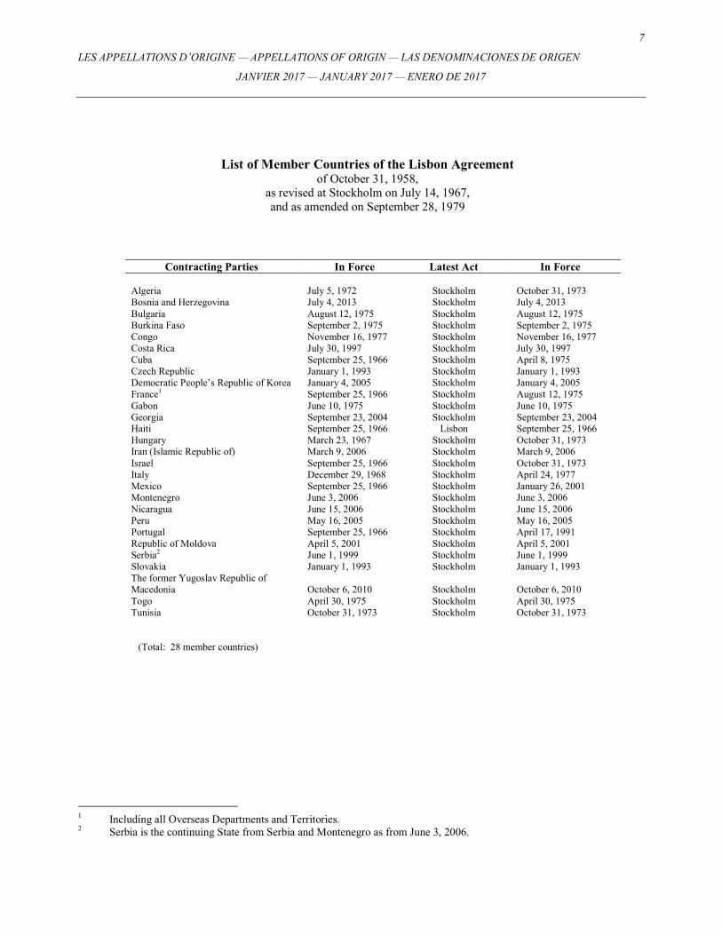
List of Member Countries of the Lisbon Agreement of October 31, 1958,
as revised at Stockholm on July 14, 1967, and as amended on September 28, 1979
Contracting Parties In Force Latest Act In Force Algeria July 5, 1972 Stockholm October 31, 1973 Bosnia and Herzegovina July 4, 2013 Stockholm July 4, 2013 Bulgaria August 12, 1975 Stockholm August 12, 1975 Burkina Faso September 2, 1975 Stockholm September 2, 1975 Congo November 16, 1977 Stockholm November 16, 1977 Costa Rica July 30, 1997 Stockholm July 30, 1997 Cuba September 25, 1966 Stockholm April 8, 1975 Czech Republic January 1, 1993 Stockholm January 1, 1993 Democratic People’s Republic of Korea January 4, 2005 Stockholm January 4, 2005 France1 September 25, 1966 Stockholm August 12, 1975 Gabon June 10, 1975 Stockholm June 10, 1975 Georgia September 23, 2004 Stockholm September 23, 2004 Haiti September 25, 1966 Lisbon September 25, 1966 Hungary March 23, 1967 Stockholm October 31, 1973 Iran (Islamic Republic of) March 9, 2006 Stockholm March 9, 2006 Israel September 25, 1966 Stockholm October 31, 1973 Italy December 29, 1968 Stockholm April 24, 1977 Mexico September 25, 1966 Stockholm January 26, 2001 Montenegro June 3, 2006 Stockholm June 3, 2006 Nicaragua June 15, 2006 Stockholm June 15, 2006 Peru May 16, 2005 Stockholm May 16, 2005 Portugal September 25, 1966 Stockholm April 17, 1991 Republic of Moldova April 5, 2001 Stockholm April 5, 2001 Serbia2 June 1, 1999 Stockholm June 1, 1999 Slovakia January 1, 1993 Stockholm January 1, 1993 The former Yugoslav Republic of Macedonia
October 6, 2010
Stockholm
October 6, 2010
Togo April 30, 1975 Stockholm April 30, 1975 Tunisia October 31, 1973 Stockholm October 31, 1973
(Total: 28 member countries)
1 Including all Overseas Departments and Territories. 2 Serbia is the continuing State from Serbia and Montenegro as from June 3, 2006.
8
LES APPELLATIONS D’ORIGINE — APPELLATIONS OF ORIGIN — LAS DENOMINACIONES DE ORIGEN
JANVIER 2017 — JANUARY 2017 — ENERO DE 2017
Observaciones relativas a la publicación del Boletín “Las denominaciones de origen”
La Oficina Internacional de la Organización Mundial de la Propiedad Intelectual (OMPI) publica el Boletín “Las denominaciones de origen” en aplicación del Artículo 5.2) del Arreglo de Lisboa relativo a la Protección de las Denominaciones de Origen y su Registro internacional del 31 de octubre de 1958, revisado en Estocolmo el 14 de julio de 1967, y de la Regla 18 del Reglamento de dicho Arreglo (texto en vigor el 1 de enero de 2016).
Cada número puede incluir, en particular, alguna de las rúbricas siguientes, cuya materia se desglosa según los números de registros y las fechas de registros:
– Registros – Declaraciones de denegación (total o parcial*) – Retiros de declaración de denegación (retiro total o parcial*) – Declaraciones de concesión de la protección – Concesiones de un plazo para poner fin a la utilización de una
denominación de origen – Invalidaciones – Modificaciones – Renuncias – Cancelaciones – Correcciones
Sólo pueden registrarse en la OMPI, y recibir protección en virtud de las
disposiciones del Arreglo de Lisboa, las denominaciones de origen de productos procedentes de países miembros de la Unión de Lisboa y que estén reconocidos y protegidos como tales en el país de origen.
La Unión de Lisboa constituye actualmente 28 países miembros.
* De conformidad con la Regla 18 del Reglamento, la Oficina Internacional publica en el Boletín todas las inscripciones
efectuadas en el Registro Internacional. Además, a partir del N.° 36 del Boletín, también publica el texto de las denegaciones parciales y retiros parciales, en el idioma de la notificación de denegación o de retiro en cuestión.
9
LES APPELLATIONS D’ORIGINE — APPELLATIONS OF ORIGIN — LAS DENOMINACIONES DE ORIGEN
JANVIER 2017 — JANUARY 2017 — ENERO DE 2017
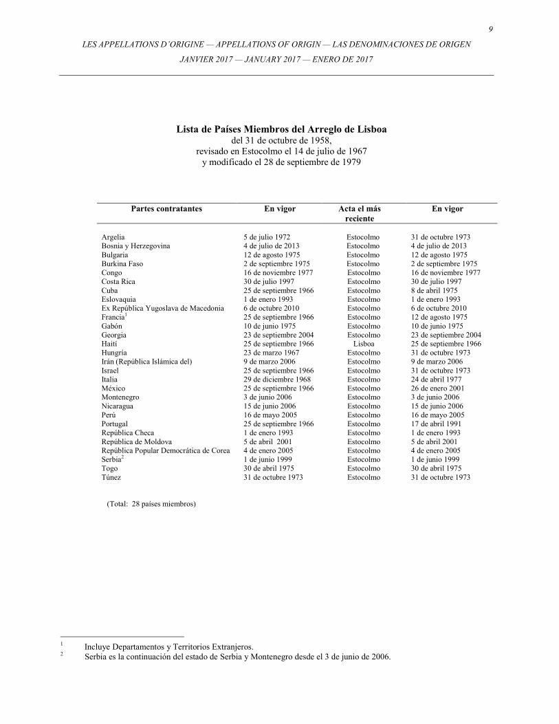
Lista de Países Miembros del Arreglo de Lisboa del 31 de octubre de 1958,
revisado en Estocolmo el 14 de julio de 1967 y modificado el 28 de septiembre de 1979
Partes contratantes En vigor Acta el más reciente
En vigor
Argelia 5 de julio 1972 Estocolmo 31 de octubre 1973 Bosnia y Herzegovina 4 de julio de 2013 Estocolmo 4 de julio de 2013 Bulgaria 12 de agosto 1975 Estocolmo 12 de agosto 1975 Burkina Faso 2 de septiembre 1975 Estocolmo 2 de septiembre 1975 Congo 16 de noviembre 1977 Estocolmo 16 de noviembre 1977 Costa Rica 30 de julio 1997 Estocolmo 30 de julio 1997 Cuba 25 de septiembre 1966 Estocolmo 8 de abril 1975 Eslovaquia 1 de enero 1993 Estocolmo 1 de enero 1993 Ex República Yugoslava de Macedonia 6 de octubre 2010 Estocolmo 6 de octubre 2010 Francia1 25 de septiembre 1966 Estocolmo 12 de agosto 1975 Gabón 10 de junio 1975 Estocolmo 10 de junio 1975 Georgia 23 de septiembre 2004 Estocolmo 23 de septiembre 2004 Haití 25 de septiembre 1966 Lisboa 25 de septiembre 1966 Hungría 23 de marzo 1967 Estocolmo 31 de octubre 1973 Irán (República Islámica del) 9 de marzo 2006 Estocolmo 9 de marzo 2006 Israel 25 de septiembre 1966 Estocolmo 31 de octubre 1973 Italia 29 de diciembre 1968 Estocolmo 24 de abril 1977 México 25 de septiembre 1966 Estocolmo 26 de enero 2001 Montenegro 3 de junio 2006 Estocolmo 3 de junio 2006 Nicaragua 15 de junio 2006 Estocolmo 15 de junio 2006 Perú 16 de mayo 2005 Estocolmo 16 de mayo 2005 Portugal 25 de septiembre 1966 Estocolmo 17 de abril 1991 República Checa 1 de enero 1993 Estocolmo 1 de enero 1993 República de Moldova 5 de abril 2001 Estocolmo 5 de abril 2001 República Popular Democrática de Corea 4 de enero 2005 Estocolmo 4 de enero 2005 Serbia2 1 de junio 1999 Estocolmo 1 de junio 1999 Togo 30 de abril 1975 Estocolmo 30 de abril 1975 Túnez 31 de octubre 1973 Estocolmo 31 de octubre 1973
(Total: 28 países miembros)
1 Incluye Departamentos y Territorios Extranjeros. 2 Serbia es la continuación del estado de Serbia y Montenegro desde el 3 de junio de 2006.

10 LES APPELLATIONS D’ORIGINE — APPELLATIONS OF ORIGIN — LAS DENOMINACIONES DE ORIGEN
JANVIER 2017 — JANUARY 2017 — ENERO DE 2017
11
LES APPELLATIONS D’ORIGINE — APPELLATIONS OF ORIGIN — LAS DENOMINACIONES DE ORIGEN
JANVIER 2017 — JANUARY 2017 — ENERO DE 2017
ENREGISTREMENTS / REGISTRATIONS / REGISTROS
Nos. 1037 - 1061
12 LES APPELLATIONS D’ORIGINE — APPELLATIONS OF ORIGIN — LAS DENOMINACIONES DE ORIGEN
JANVIER 2017 — JANUARY 2017 — ENERO DE 2017
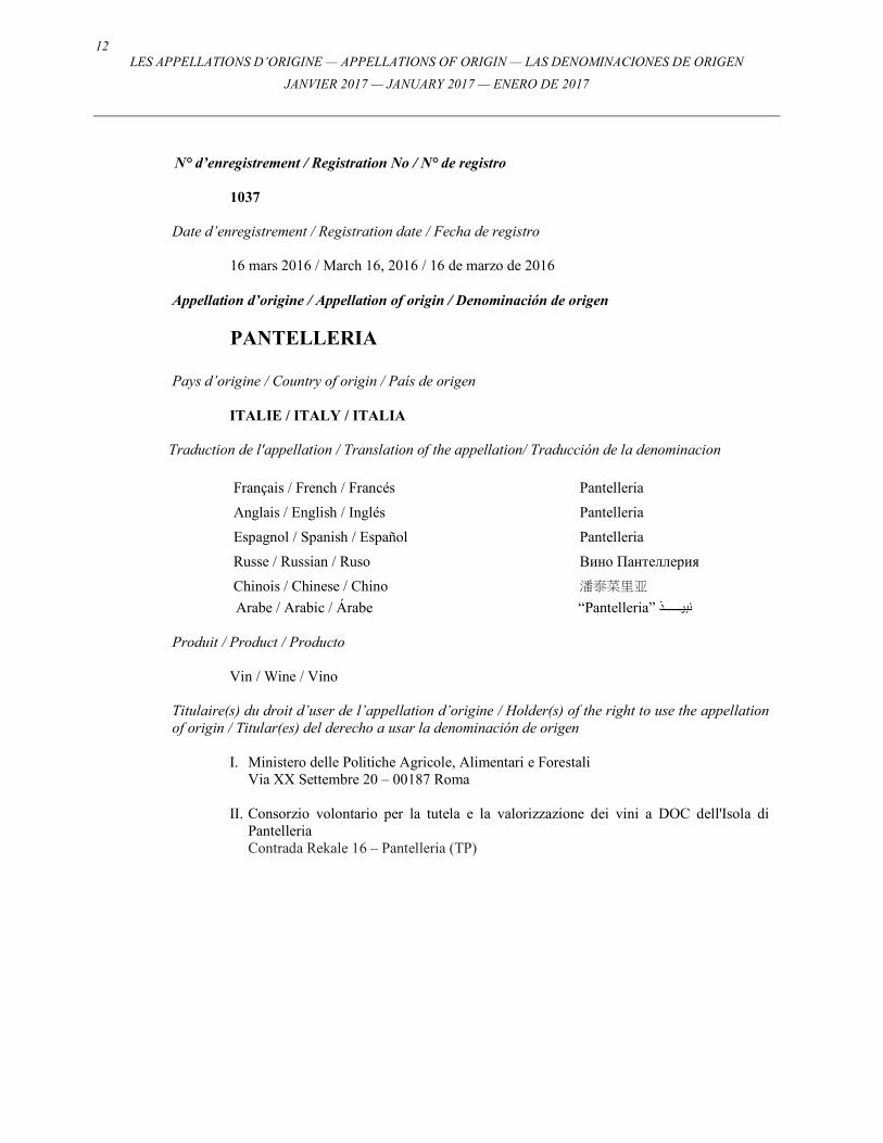
N° d’enregistrement / Registration No / N° de registro
1037
Date d’enregistrement / Registration date / Fecha de registro
16 mars 2016 / March 16, 2016 / 16 de marzo de 2016 Appellation d’origine / Appellation of origin / Denominación de origen
PANTELLERIA
Pays d’origine / Country of origin / País de origen
ITALIE / ITALY / ITALIA
Traduction de l'appellation / Translation of the appellation/ Traducción de la denominacion
Français / French / Francés Pantelleria
Anglais / English / Inglés Pantelleria
Espagnol / Spanish / Español Pantelleria
Russe / Russian / Ruso Вино Пантеллерия
Chinois / Chinese / Chino 潘泰菜里亚
Arabe / Arabic / Árabe “Pantelleria” نبي����������ذ
Produit / Product / Producto
Vin / Wine / Vino
Titulaire(s) du droit d’user de l’appellation d’origine / Holder(s) of the right to use the appellation of origin / Titular(es) del derecho a usar la denominación de origen
I. Ministero delle Politiche Agricole, Alimentari e Forestali Via XX Settembre 20 – 00187 Roma
II. Consorzio volontario per la tutela e la valorizzazione dei vini a DOC dell'Isola di
Pantelleria Contrada Rekale 16 – Pantelleria (TP)
13
LES APPELLATIONS D’ORIGINE — APPELLATIONS OF ORIGIN — LAS DENOMINACIONES DE ORIGEN
JANVIER 2017 — JANUARY 2017 — ENERO DE 2017
Aire de production / Area of production / Área de producción
▪ L’aire de production des raisins utilisés pour la production des vins avec Appellation d’Origine Contrôllée “Pantelleria” comprend l’ensemble du territoire de l’île de Pantelleria, dans la province de Trapani. /
▪ The area of origin of grapes used for the production of the Controlled Designation of
Origin wines “Pantelleria” includes the entire territory of Pantelleria Island, in the province of Trapani. /
▪ El área de origen de las uvas utilizadas para la producción de vinos con la
Denominación de Origen Controlada “Pantelleria” incluye todo el territorio de la Isla de Pantelaria, en la provincia de Trapani.
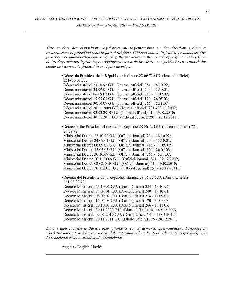
Titre et date des dispositions législatives ou réglementaires ou des décisions judiciaires reconnaissant la protection dans le pays d’origine / Title and date of legislative or administrative provisions or judicial decisions recognizing the protection in the country of origin / Título y fecha de las disposiciones legislativas o administrativas o de las decisiones judiciales en virtud de las cuales se reconoce la protección en el país de origen
▪ Décret du Président de la République italienne 11.08.1971, G.U. (Journal officiel) 239 - 22.09.1971; Décret ministériel 11.08.1992, G.U. (Journal officiel) 195 - 20.08.1992; Décret ministériel 27.09.2000, G.U. (Journal officiel) 234 - 06.10.2000; Décret ministériel 07.10.2011, G.U. (Journal officiel) 242 - 17.10.2011; Décret ministériel 30.11.2011, G.U. (Journal officiel) 295 - 20.12.2011; Décret ministériel 28.10.2013; Décret ministériel 07.03.2014. / ▪ Decree of the President of the Italian Republic 11.08.1971, G.U. (Official Journal) 239 -
22.09.1971; Ministerial Decree 11.08.1992, G.U. (Official Journal) 195 - 20.08.1992; Ministerial Decree 27.09.2000, G.U. (Official Journal) 234 - 06.10.2000; Ministerial Decree 07.10.2011, G.U. (Official Journal) 242 - 17.10.2011; Ministerial Decree 30.11.2011, G.U. (Official Journal) 295 - 20.12.2011; Ministerial Decree 28.10.2013; Ministerial Decree 07.03.2014. /
▪ Decreto del Presidente de la República italiana 11.08.1971, G.U. (Diario Oficial) 239 -
22.09.1971; Decreto ministerial 11.08.1992, G.U. (Diario Oficial) 195 - 20.08.1992; Decreto ministerial 27.09.2000, G.U. (Diario Oficial) 234 - 06.10.2000; Decreto ministerial 07.10.2011, G.U. (Diario Oficial) 242 - 17.10.2011; Decreto ministerial 30.11.2011, G.U. (Diario Oficial) 295 - 20.12.2011; Decreto ministerial 28.10.2013; Decreto ministerial 07.03.2014.
Langue dans laquelle le Bureau international a reçu la demande internationale / Language in which the International Bureau received the international application / Idioma en el que la Oficina Internacional recibió la solicitud internacional
Anglais / English / Inglés
14 LES APPELLATIONS D’ORIGINE — APPELLATIONS OF ORIGIN — LAS DENOMINACIONES DE ORIGEN
JANVIER 2017 — JANUARY 2017 — ENERO DE 2017
N° d’enregistrement / Registration No / N° de registro
1038
Date d’enregistrement / Registration date / Fecha de registro
16 mars 2016 / March 16, 2016 / 16 de marzo de 2016 Appellation d’origine / Appellation of origin / Denominación de origen
TREBBIANO D’ABRUZZO
Pays d’origine / Country of origin / País de origen
ITALIE / ITALY / ITALIA
Traduction de l'appellation / Translation of the appellation/ Traducción de la denominacion
Français / French / Francés Trebbiano d’Abruzzo
Anglais / English / Inglés Trebbiano d’Abruzzo
Espagnol / Spanish / Español Trebbiano d’Abruzzo
Russe / Russian / Ruso Вино Треббьяно д'Абруццо
Chinois / Chinese / Chino 特内比亚诺迪瓦阿布鲁佐
Arabe / Arabic / Árabe “Trebbiano d’Abruzzo” نبي����������ذ
Produit / Product / Producto
Vin / Wine / Vino
Titulaire(s) du droit d’user de l’appellation d’origine / Holder(s) of the right to use the appellation of origin / Titular(es) del derecho a usar la denominación de origen
I. Ministero delle Politiche Agricole, Alimentari e Forestali Via XX Settembre 20 – 00187 Roma
II. Consorzio Tutela Vini d'Abruzzo
c/o Enoteca Regionale d'Abruzzo, Corso Matteotti – Palazzo Corvo – 66026 Ortona (CH)
15
LES APPELLATIONS D’ORIGINE — APPELLATIONS OF ORIGIN — LAS DENOMINACIONES DE ORIGEN
JANVIER 2017 — JANUARY 2017 — ENERO DE 2017
Aire de production / Area of production / Área de producción
▪ Tout ou partie des territoires des communes dans les provinces suivantes:
1) dans la province de Chieti: Altino, Archi, Ari, Arielli, Atessa, Bomba, Bucchianico, Canosa Sannita, Casacanditella, Casalanguida, Casalincontrada, Carpineto Sinello, Casalbordino, Casoli, Castel Frentano, Celenza sul Trigno, Chieti, Crecchio, Cupello, Fara Filiorum Petri, Filetto, Fossacesia, Francavilla, Fresagrandinaria, Frisa, Furci, Gissi, Giuliano Teatino, Guardiagrele, Lanciano, Lentella, Miglianico, Monteodorisio, Mozzagrogna, Orsogna, Ortona, Paglieta, Palmoli, Perano, Poggiofiorito, Pollutri, Ripa Teatina, Roccamontepiano, Rocca San Giovanni, San Buono, Sant’Eusanio del Sangro, San Giovanni Teatino, Santa Maria Imbaro, San Martino sulla Marrucina, San Salvo, San Vito Chietino, Scerni, Tollo, Torino di Sangro, Torrevecchia Teatina, Treglio, Vasto, Villalfonsina, Villamagna, Vacri; 2) dans la province de L’Aquila: Acciano, Anversa degli Abruzzi, Balsorano, Bugnara, Canistro, Capestrano, Castel di Ieri, Castelvecchio Subequo, Civita d’Antino, Civitella Roveto, Cocullo, Corfinio, Fagnano Alto, Fontecchio, Fossa, Gagliano Aterno, Goriano Sicoli, Introdacqua, Molina Aterno, Morino, Ofena, Pacentro, Poggio Picenze, Pratola Peligna, Pettorano sul Gizio, Prezza, Raiano, Rocca Casale, San Demetrio nei Vestini, Sant’Eusanio Forconese, San Vincenzo Valle Roveto, Secinaro, Sulmona, Tione d’Abruzzi, Villa S. Angelo, Villa S. Lucia, Vittorito; 3) dans la province de Pescara: Alanno, Bolognano, Brittoli, Bussi, Cappelle sul Tavo, Castiglione a Casauria, Catignano, Cepagatti, Città Sant’Angelo, Civitella Casanova, Civitaquana, Collecorvino, Corvara, Cugnoli, Elice, Farindola, Lettomanoppello, Loreto Aprutino, Manoppello, Montebello di Bertona, Montesilvano, Moscufo, Nocciano, Penne, Pianella, Pietranico, Picciano, Pescara, Pescosansonesco, Popoli, Rosciano, San Valentino, Scafa, Serramonacesca, Spoltore, Tocco da Casauria, Torre de’ Passeri, Turrivalignani, Vicoli; 4) dans la province de Teramo: Alba Adriatica, Ancarano, Atri, Basciano, Bellante, Bisenti, Campli, Canzano, Castel Castagno, Castellato, Castiglione Messer Raimondi, Castilenti, Cellino Attanasio, Cermignano, Civitella del Tronto, Colledara, Colonnella, Controguerra, Corropoli, Giulianova, Martinsicuro, Montefino, Montorio al Vomano, Morrodoro, Mosciano, Nereto, Notaresco, Penna S. Andrea, Pineto, Roseto degli Abruzzi, Sant’Egidio, Sant’Omero, Silvi, Teramo, Torano Nuovo, Tortoreto, Tossicia et la zone de Trignano dans la commune de Isola del Gran Sasso. /
▪ The entire or part of the territories of the municipalities in the following provinces:
l) in the province of Chieti: Altino, Archi, Ari, Arielli, Atessa, Bomba, Bucchianico, Canosa Sannita, Casacanditella, Casalanguida, Casalincontrada, Carpineto Sinello, Casalbordino, Casoli, Castel Frentano, Celenza sul Trigno, Chieti, Crecchio, Cupello, Fara Filiorum Petri, Filetto, Fossacesia, Francavilla, Fresagrandinaria, Frisa, Furci, Gissi, Giuliano Teatino, Guardiagrele, Lanciano, Lentella, Miglianico, Monteodorisio, Mozzagrogna, Orsogna, Ortona, Paglieta, Palmoli, Perano, Poggiofiorito, Pollutri, Ripa Teatina, Roccamontepiano, Rocca San Giovanni, San Buono, Sant'Eusanio del Sangro, San Giovanni Teatino, Santa Maria Imbaro, San Martino sulla Marrucina, San Salvo, San Vito Chietino, Scerni, Tollo, Torino di Sangro, Torrevecchia Teatina, Treglio, Vasto, Villalfonsina, Villamagna, Vacri; 2) in the province of L’Aquila: Acciano, Anversa degli Abruzzi, Balsorano, Bugnara, Canistro, Capestrano, Castel di Ieri, Castelvecchio Subequo, Civita d'Antino, Civitella Roveto, Cocullo, Corfinio, Fagnano Alto, Fontecchio, Fossa, Gagliano Aterno, Goriano Sicoli, Introdacqua, Molina Aterno, Morino, Ofena, Pacentro, Poggio Picenze, Pratola Peligna, Pettorano sul Gizio, Prezza, Raiano, Rocca Casale, San Demetrio nei Vestini, Sant'Eusanio Forconese, San Vincenzo Valle Roveto, Secinaro, Sulmona, Tione d'Abruzzi, Villa S. Angelo, Villa S. Lucia, Vittorito;
16 LES APPELLATIONS D’ORIGINE — APPELLATIONS OF ORIGIN — LAS DENOMINACIONES DE ORIGEN
JANVIER 2017 — JANUARY 2017 — ENERO DE 2017
3) in the province of Pescara: Alanno, Bolognano, Brittoli, Bussi, Cappelle sul Tavo, Castiglione a Casauria, Catignano, Cepagatti, Citta Sant'Angelo, Civitella Casanova, Civitaquana, Collecorvino, Corvara, Cugnoli, Elice, Farindola, Lettomanoppello, Loreto Aprutino, Manoppello, Montebello di Bertona, Montesilvano, Moscufo, Nocciano, Penne, Pianella, Pietranico, Picciano, Pescara, Pescosansonesco, Popoli, Rosciano, San Valentino, Scafa, Serramonacesca, Spoltore, Tocco da Casauria, Torre de’ Passeri, Turrivalignani, Vicoli; 4) in the province of Teramo: Alba Adriatica, Ancarano, Atri, Basciano, Bellante, Bisenti, Campli, Canzano, Castel Castagno, Castellato, Castiglione Messer Raimondi, Castilenti, Cellino Attanasio, Cermignano, Civitella del Tronto, Colledara, Colonnella, Controguerra, Corropoli, Giulianova, Martinsicuro, Montefino, Montorio al Vomano, Morrodoro, Mosciano, Nereto, Notaresco, Penna S. Andrea, Pineto, Roseto degli Abruzzi, Sant'Egidio, Sant'Omero, Silvi, Teramo, Torano Nuovo, Tortoreto, Tossicia and the area of Trignano in the municipality of Isola del Gran Sasso. /
▪ Todo o parte de los territorios de los municipios de las siguientes provincias:
1) en la provincia de Chieti: Altino, Archi, Ari, Arielli, Atessa, Bomba, Bucchianico, Canosa Sannita, Casacanditella, Casalanguida, Casalincontrada, Carpineto Sinello, Casalbordino, Casoli, Castel Frentano, Celenza sul Trigno, Chieti, Crecchio, Cupello, Fara Filiorum Petri, Filetto, Fossacesia, Francavilla, Fresagrandinaria, Frisa, Furci, Gissi, Giuliano Teatino, Guardiagrele, Lanciano, Lentella, Miglianico, Monteodorisio, Mozzagrogna, Orsogna, Ortona, Paglieta, Palmoli, Perano, Poggiofiorito, Pollutri, Ripa Teatina, Roccamontepiano, Rocca San Giovanni, San Buono, Sant'Eusanio del Sangro, San Giovanni Teatino, Santa Maria Imbaro, San Martino sulla Marrucina, San Salvo, San Vito Chietino, Scerni, Tollo, Torino di Sangro, Torrevecchia Teatina, Treglio, Vasto, Villalfonsina, Villamagna, Vacri; 2) en la provincia de L'Aquila: Acciano, Anversa degli Abruzzi, Balsorano, Bugnara, Canistro, Capestrano, Castel di Ieri, Castelvecchio Subequo, Civita d'Antino, Civitella Roveto, Cocullo, Corfinio, Fagnano Alto, Fontecchio, Fossa, Gagliano Aterno, Goriano Sicoli, Introdacqua, Molina Aterno, Morino, Ofena, Pacentro, Poggio Picenze, Pratola Peligna, Pettorano sul Gizio, Prezza, Raiano, Rocca Casale, San Demetrio nei Vestini, Sant'Eusanio Forconese, San Vincenzo Valle Roveto, Secinaro, Sulmona, Tione d'Abruzzi, Villa S. Angelo, Villa S. Lucia, Vittorito. 3) en la provincia de Pescara: Alanno, Bolognano, Brittoli, Bussi, Cappelle sul Tavo, Castiglione a Casauria, Catignano, Cepagatti, Citta Sant'Angelo, Civitella Casanova, Civitaquana, Collecorvino, Corvara, Cugnoli, Elice, Farindola, Lettomanoppello, Loreto Aprutino, Manoppello, Montebello di Bertona, Montesilvano, Moscufo, Nocciano, Penne, Pianella, Pietranico, Picciano, Pescara, Pescosansonesco, Popoli, Rosciano, San Valentino, Scafa, Serramonacesca, Spoltore, Tocco da Casauria, Torre de’ Passeri, Turrivalignani, Vicoli; 4) en la provincia de Teramo: Alba Adriatica, Ancarano, Atri, Basciano, Bellante, Bisenti, Campli, Canzano, Castel Castagno, Castellato, Castiglione Messer Raimondi, Castilenti, Cellino Attanasio, Cermignano, Civitella del Tronto, Colledara, Colonnella, Controguerra, Corropoli, Giulianova, Martinsicuro, Montefino, Montorio al Vomano, Morrodoro, Mosciano, Nereto, Notaresco, Penna S. Andrea, Pineto, Roseto degli Abruzzi, Sant'Egidio, Sant'Omero, Silvi, Teramo, Torano Nuovo, Tortoreto, Tossicia y el área de Trignano en el municipio de Isola del Gran Sasso.
17
LES APPELLATIONS D’ORIGINE — APPELLATIONS OF ORIGIN — LAS DENOMINACIONES DE ORIGEN
JANVIER 2017 — JANUARY 2017 — ENERO DE 2017
Titre et date des dispositions législatives ou réglementaires ou des décisions judiciaires reconnaissant la protection dans le pays d’origine / Title and date of legislative or administrative provisions or judicial decisions recognizing the protection in the country of origin / Título y fecha de las disposiciones legislativas o administrativas o de las decisiones judiciales en virtud de las cuales se reconoce la protección en el país de origen
▪ Décret du Président de la République italienne 28.06.72 G.U. (Journal officiel) 221- 25.08.72; Décret ministériel 23.10.92 G.U. (Journal officiel) 254 - 28.10.92; Décret ministériel 24.09.01 G.U. (Journal officiel) 240 - 15.10.01; Décret ministériel 06.09.02 G.U. (Journal officiel) 218 - 17.09.02; Décret ministériel 15.05.03 G.U. (Journal officiel) 120 - 26.05.03; Décret ministériel 30.10.07 G.U. (Journal officiel) 266 - 15.11.07; Décret ministériel 20.11.2009 G.U. (Journal officiel) 281 - 02.12.2009; Décret ministériel 02.02.2010 G.U. (Journal officiel) 41 - 19.02.2010; Décret ministériel 30.11.2011 G.U. (Official Journal) 295 - 20.12.2011. /
▪ Decree of the President of the Italian Republic 28.06.72 G.U. (Official Journal) 221-25.08.72; Ministerial Decree 23.10.92 G.U. (Official Journal) 254 - 28.10.92; Ministerial Decree 24.09.01 G.U. (Official Journal) 240 - 15.10.01; Ministerial Decree 06.09.02 G.U. (Official Journal) 218 - 17.09.02; Ministerial Decree 15.05.03 G.U. (Official Journal) 120 - 26.05.03; Ministerial Decree 30.10.07 G.U. (Official Journal) 266 - 15.11.07; Ministerial Decree 20.11.2009 G.U. (Official Journal) 281 - 02.12.2009; Ministerial Decree 02.02.2010 G.U. (Official Journal) 41 - 19.02.2010; Ministerial Decree 30.11.2011 G.U. (Official Journal) 295 - 20.12.2011. /
▪ Decreto del Presidente de la República Italiana 28.06.72 G.U. (Diario Oficial) 221 25.08.72; Decreto Ministerial 23.10.92 G.U. (Diario Oficial) 254 - 28.10.92; Decreto Ministerial 24.09.01 G.U. (Diario Oficial) 240 - 15.10.01; Decreto Ministerial 06.09.02 G.U. (Diario Oficial) 218 - 17.09.02; Decreto Ministerial 15.05.03 G.U. (Diario Oficial) 120 - 26.05.03; Decreto Ministerial 30.10.07 G.U. (Diario Oficial) 266 - 15.11.07; Decreto Ministerial 20.11.2009 G.U. (Diario Oficial) 281 - 02.12.2009; Decreto Ministerial 02.02.2010 G.U. (Diario Oficial) 41 - 19.02.2010; Decreto Ministerial 30.11.2011 G.U. (Diario Oficial) 295 - 20.12.2011.
Langue dans laquelle le Bureau international a reçu la demande internationale / Language in which the International Bureau received the international application / Idioma en el que la Oficina Internacional recibió la solicitud internacional
Anglais / English / Inglés
18 LES APPELLATIONS D’ORIGINE — APPELLATIONS OF ORIGIN — LAS DENOMINACIONES DE ORIGEN
JANVIER 2017 — JANUARY 2017 — ENERO DE 2017
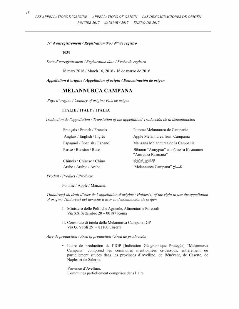
N° d’enregistrement / Registration No / N° de registro
1039
Date d’enregistrement / Registration date / Fecha de registro
16 mars 2016 / March 16, 2016 / 16 de marzo de 2016
Appellation d’origine / Appellation of origin / Denominación de origen
MELANNURCA CAMPANA Pays d’origine / Country of origin / País de origen
ITALIE / ITALY / ITALIA Traduction de l'appellation / Translation of the appellation/ Traducción de la denominacion
Français / French / Francés Pomme Melannurca de Campanie
Anglais / English / Inglés Apple Melannurca from Campania
Espagnol / Spanish / Español Manzana Melannurca de la Campania
Russe / Russian / Ruso Яблоки “Аннурка” из области Кампания “Аннурка Кампана”
Chinois / Chinese / Chino 坎帕利亚苹果
Arabe / Arabic / Árabe “Melannurca Campana” تف���������اح Produit / Product / Producto
Pomme / Apple / Manzana
Titulaire(s) du droit d’user de l’appellation d’origine / Holder(s) of the right to use the appellation of origin / Titular(es) del derecho a usar la denominación de origen
I. Ministero delle Politiche Agricole, Alimentari e Forestali Via XX Settembre 20 – 00187 Roma
II. Consorzio di tutela della Melannurca Campana IGP
Via G. Verdi 29 – 81100 Caserta
Aire de production / Area of production / Área de producción
▪ L’aire de production de l’IGP [Indication Géographique Protégée] “Melannurca Campana” comprend les communes mentionnées ci-dessous, entièrement ou partiellement situées dans les provinces d’Avellino, de Bénévent, de Caserte, de Naples et de Salerne.
Province d’Avellino. Communes partiellement comprises dans l’aire:
19
LES APPELLATIONS D’ORIGINE — APPELLATIONS OF ORIGIN — LAS DENOMINACIONES DE ORIGEN
JANVIER 2017 — JANUARY 2017 — ENERO DE 2017
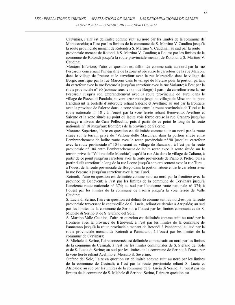
Cervinara, l’aire est délimitée comme suit: au nord par les limites de la commune de Montesarchio; à l’est par les limites de la commune de S. Martino V. Caudina jusqu’à la route provinciale menant de Rotondi à S. Martino V. Caudina ; au sud par la route provinciale menant de Rotondi à S. Martino V. Caudina; à l’ouest par les limites de la commune de Rotondi jusqu’à la route provinciale menant de Rotondi à S. Martino V. Caudina; Montoro Inferiore, l’aire en question est délimitée comme suit: au nord par la rue Pescarola concernant l’intégralité de la zone située entre le carrefour de la rue Marconi dans le village de Preturo et le carrefour avec la rue Mercatello dans le village de Borgo, ainsi que par la rue Marconi dans le village de Preturo pour la portion partant du carrefour avec la rue Pescarola jusqu’au carrefour avec la rue Variante; à l’est par la route provinciale n° 90 (connue sous le nom de Borgo) à partir du carrefour avec la rue Pescarola jusqu’à son embranchement avec la route provinciale de Turci dans le village de Piazza di Pandola, suivant cette route jusqu’au village de Misciano au pont franchissant la bretelle d’autoroute reliant Salerne et Avellino; au sud par la frontière avec la province de Salerne dans la zone située entre la route provinciale de Turci et la route nationale n° 18 ; à l’ouest par la voie ferrée reliant Benevento, Avellino et Salerne et la zone située au point où ladite voie ferrée croise la rue Granaro jusqu’au passage à niveau de Casa Pellecchia, puis à partir de ce point le long de la route nationale n° 18 jusqu’aux frontières de la province de Salerne; Montoro Superiore, l’aire en question est délimitée comme suit: au nord par la route située sur le terrain privé de “Vallone delle Macchie», dans la portion située entre l’embranchement de ladite route avec la route provinciale n° 90 jusqu’au carrefour avec la route provinciale n° 104 menant au village de Banzano ; à l’est par la route provinciale n° 104 entre l’embranchement de ladite route avec la route située sur le terrain privé de “Vallone delle Macchie”jusqu’à la rue Aia dans le village de Caliano, à partir de ce point jusqu’au carrefour avec la route provinciale de Piano S. Pietro, puis à partir dudit carrefour le long de la rue Leono jusqu’à son croisement avec la rue Turci ; à l’ouest de la route provinciale de Borgo dans la portion située entre le carrefour avec la rue Pescarola jusqu’au carrefour avec la rue Turci. Rotondi, l’aire en question est délimitée comme suit: au nord par la frontière avec la province de Bénévent; à l’est par les limites de la commune de Cervinara jusqu’à l’ancienne route nationale n° 374; au sud par l’ancienne route nationale n° 374; à l’ouest par les limites de la commune de Paolisi jusqu’à la voie ferrée de Valle Caudina; S. Lucia di Serino, l’aire en question est délimitée comme suit: au nord-est par la route provinciale traversant le centre-ville de S. Lucia, reliant ce dernier à Atripalda; au sud par les limites de la commune de Serino; à l’ouest par les limites communales de S. Michele di Serino et de S. Stefano del Sole; S. Martino Valle Caudina, l’aire en question est délimitée comme suit: au nord par la frontière avec la province de Bénévent; à l’est par les limites de la commune de Pannarano jusqu’à la route provinciale menant de Rotondi à Pannarano; au sud par la route provinciale menant de Rotondi à Pannarano; à l’ouest par les limites de la commune de Cervinara; S. Michele di Serino, l’aire concernée est délimitée comme suit: au nord par les limites de la commune de Cesinali; à l’est par les limites communales de S. Stefano del Sole et de S. Lucia di Serino; au sud par les limites de la commune de Serino; à l’ouest par la voie ferrée reliant Avellino et Mercato S. Severino; Stefano del Sole, l’aire en question est délimitée comme suit: au nord par les limites de la commune de Cesinali; à l’est par la route provinciale reliant S. Lucia et Atripalda; au sud par les limites de la commune de S. Lucia di Serino; à l’ouest par les limites de la commune de S. Michele di Serino; Serino, l’aire en question est
20 LES APPELLATIONS D’ORIGINE — APPELLATIONS OF ORIGIN — LAS DENOMINACIONES DE ORIGEN
JANVIER 2017 — JANUARY 2017 — ENERO DE 2017
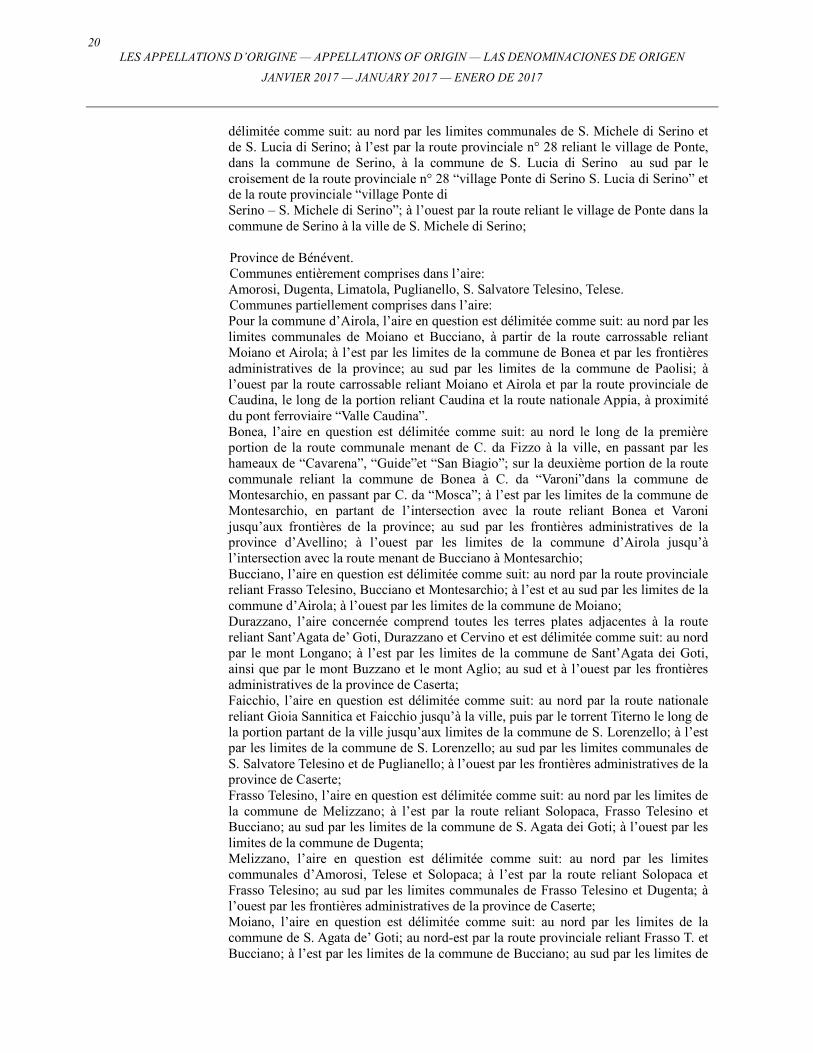
délimitée comme suit: au nord par les limites communales de S. Michele di Serino et de S. Lucia di Serino; à l’est par la route provinciale n° 28 reliant le village de Ponte, dans la commune de Serino, à la commune de S. Lucia di Serino au sud par le croisement de la route provinciale n° 28 “village Ponte di Serino S. Lucia di Serino” et de la route provinciale “village Ponte di Serino – S. Michele di Serino”; à l’ouest par la route reliant le village de Ponte dans la commune de Serino à la ville de S. Michele di Serino; Province de Bénévent. Communes entièrement comprises dans l’aire: Amorosi, Dugenta, Limatola, Puglianello, S. Salvatore Telesino, Telese. Communes partiellement comprises dans l’aire: Pour la commune d’Airola, l’aire en question est délimitée comme suit: au nord par les limites communales de Moiano et Bucciano, à partir de la route carrossable reliant Moiano et Airola; à l’est par les limites de la commune de Bonea et par les frontières administratives de la province; au sud par les limites de la commune de Paolisi; à l’ouest par la route carrossable reliant Moiano et Airola et par la route provinciale de Caudina, le long de la portion reliant Caudina et la route nationale Appia, à proximité du pont ferroviaire “Valle Caudina”. Bonea, l’aire en question est délimitée comme suit: au nord le long de la première portion de la route communale menant de C. da Fizzo à la ville, en passant par les hameaux de “Cavarena”, “Guide”et “San Biagio”; sur la deuxième portion de la route communale reliant la commune de Bonea à C. da “Varoni”dans la commune de Montesarchio, en passant par C. da “Mosca”; à l’est par les limites de la commune de Montesarchio, en partant de l’intersection avec la route reliant Bonea et Varoni jusqu’aux frontières de la province; au sud par les frontières administratives de la province d’Avellino; à l’ouest par les limites de la commune d’Airola jusqu’à l’intersection avec la route menant de Bucciano à Montesarchio; Bucciano, l’aire en question est délimitée comme suit: au nord par la route provinciale reliant Frasso Telesino, Bucciano et Montesarchio; à l’est et au sud par les limites de la commune d’Airola; à l’ouest par les limites de la commune de Moiano; Durazzano, l’aire concernée comprend toutes les terres plates adjacentes à la route reliant Sant’Agata de’ Goti, Durazzano et Cervino et est délimitée comme suit: au nord par le mont Longano; à l’est par les limites de la commune de Sant’Agata dei Goti, ainsi que par le mont Buzzano et le mont Aglio; au sud et à l’ouest par les frontières administratives de la province de Caserta; Faicchio, l’aire en question est délimitée comme suit: au nord par la route nationale reliant Gioia Sannitica et Faicchio jusqu’à la ville, puis par le torrent Titerno le long de la portion partant de la ville jusqu’aux limites de la commune de S. Lorenzello; à l’est par les limites de la commune de S. Lorenzello; au sud par les limites communales de S. Salvatore Telesino et de Puglianello; à l’ouest par les frontières administratives de la province de Caserte; Frasso Telesino, l’aire en question est délimitée comme suit: au nord par les limites de la commune de Melizzano; à l’est par la route reliant Solopaca, Frasso Telesino et Bucciano; au sud par les limites de la commune de S. Agata dei Goti; à l’ouest par les limites de la commune de Dugenta; Melizzano, l’aire en question est délimitée comme suit: au nord par les limites communales d’Amorosi, Telese et Solopaca; à l’est par la route reliant Solopaca et Frasso Telesino; au sud par les limites communales de Frasso Telesino et Dugenta; à l’ouest par les frontières administratives de la province de Caserte; Moiano, l’aire en question est délimitée comme suit: au nord par les limites de la commune de S. Agata de’ Goti; au nord-est par la route provinciale reliant Frasso T. et Bucciano; à l’est par les limites de la commune de Bucciano; au sud par les limites de
21
LES APPELLATIONS D’ORIGINE — APPELLATIONS OF ORIGIN — LAS DENOMINACIONES DE ORIGEN
JANVIER 2017 — JANUARY 2017 — ENERO DE 2017
la commune d’Airola; à l’ouest par la route provinciale reliant Airola, Moiano et S. Agata de’ Goti; Montesarchio, l’aire en question est délimitée comme suit: au nord par une portion initiale comprenant la limite entre Bonea et la ville de Montesarchio, par la route reliant Bonea à Montesarchio, en passant par C. Varoni; le long d’une deuxième portion de la route nationale Appia jusqu’aux frontières de la province; au sud par les frontières administratives de la province d’Avellino ; à l’ouest par les limites de la commune de Bonea; Paolisi, l’aire en question est délimitée comme suit: au nord par les limites de la commune d’Airola; à l’est par les frontières administratives de la province d’Avellino; au sud par la voie ferrée “Valle Caudina”; à l’ouest par les limites de la commune d’Arpaia; S. Lorenzello, l’aire en question est délimitée comme suit: au nord par le torrent de Titerno; à l’est par les limites communales de Cerreto Sannita et de Guardia Sanframondi; au sud par les limites de la commune de Castelvenere; à l’ouest par les limites communales de Faicchio et S. Salvatore Telesino; Sant’Agata Dei Goti, l’aire en question est délimitée comme suit: au nord par les limites communales de Frasso Telesino et Dugenta; à l’est par la route provinciale reliant Frasso Telesino et Bucciano, par une portion des limites de la commune de Moiano et par les routes provinciales menant de Durazzano à Agata de’ Goti et de S. Agata de’ Goti à Moiano; au sud par les limites de la commune de Durazzano; à l’ouest par les frontières administratives de la province de Caserte. Province de Caserte. Communes entièrement comprises dans l’aire: Aversa, Bellona, Caianello, Calvi Risorta, Camigliano, Carinaro, Casal Di Principe, Casaluce, Casapesenna, Cesa, Frignano, Grazzanise, Gricignano, Lusciano, Orta di Avella, Parete, Pastorano, Pignataro Maggiore, Riardo, S. Arpino, S. Cipriano d’Aversa, S. Maria la Fossa, S. Marcellino, S. Tammaro, Sparanise, Succivo, Teano, Teverola, Trentola-Ducenta, Villa di Briano, Vitulazio. Communes partiellement comprises dans l’aire: Pour la commune d’Ailano, l’aire concernée est délimitée comme suit: au nord-est par la route communale de S. Maria Zanneto, le long de la courbe de niveau 275 mètres au-dessus du niveau de la mer, jusqu’au centre d’Ailano, puis de là le long de la route communale dans la commune de Raviscanina, jusqu’à rejoindre cette commune; au sud par les limites de la commune de Vairano Patenora; Pour la commune d’Alvignano, l’aire en question est délimitée comme suit: au nord par la route privée reliant Masseria (domaine agricole) Melone et la Vecchia; à l’est par les limites de commune de Ruviano; au sud par les limites communales de Ruviano et Caiazzo; à l’ouest le long de la courbe de niveau du mont Caracciolo, à une altitude de 108 mètres au-dessus du niveau de la mer, jusqu’à la route nationale n° 158, puis le long du ruisseau de Tella jusqu’à la Masseria Melone; Baia e Latina, l’aire en question est délimitée comme suit: au nord-ouest par la route privée qui, indépendamment de la route provinciale menant de Dragoni à Baia e Latina, relie les Masseria Burelli et Morecine jusqu’aux limites de Alife; au nord-est par les limites de la commune de Alife; au sud-est par les limites de la commune de Dragoni; au sud-ouest par la route provinciale reliant Dragoni et Baia e Latina, sur la portion partant des limites de Dragoni jusqu’au pont Murato; Caiazzo, l’aire en question est délimitée comme suit: au nord par les limites de la commune d’Alvignano; à l’est par les limites de la commune de Ruviano; au sud-est par la route nationale n° 78 Sannitica, sur la portion entre les Masseria Fasulo et Pisciacchione; la ligne suit alors la route communale traversant la Masseria
22 LES APPELLATIONS D’ORIGINE — APPELLATIONS OF ORIGIN — LAS DENOMINACIONES DE ORIGEN
JANVIER 2017 — JANUARY 2017 — ENERO DE 2017
Pietramarino-la Torre et la Masseria Santoro, pour ensuite suivre la route reliant Caiazzo et Alvignano jusqu’à la Masseria Pescara et continuer vers le sud en direction de S. Pietro – Trappeto jusqu’à Mondrone; Capua, l’aire en question est délimitée comme suit: au nord par les limites communales de Vitulazio, Bellona et Pontelatone; à l’est par la route privée qui, à partir de Volturno, se dirige vers la Masseria Conte Mauro, à partir de laquelle elle suit la route nationale n°87 Sannitica en direction de C. da Mazzarella jusqu’à S. Angelo in Formis; à partir de ce point, la ligne suit la courbe de niveau 50 mètres au-dessus du niveau de la mer en direction du sud sur le mont Tifata jusqu’aux limites de S. Prisco; au sud, par les limites communales de S. Maria la Fossa, S. Tammaro, S. Maria C.V. et S. Prisco; à l’ouest par les limites de la commune de Cancello Arnone; Carinola, l’aire en question est délimitée comme suit: au nord par les limites de Sessa A. le long de la route nationale Appia jusqu’au croisement menant à Ventorali, à partir de ce point le long de la route menant à S. Ianni, suivant la route menant à Cappelle jusqu’aux limites de Teano; à l’est par les limites communales de Teano et Francolise; au sud par Ciamprisco, Nocelleto et Carinola; à l’ouest par la route menant de Carnola à Cascano; Castel di Sasso, l’aire en question est délimitée comme suit: au nord par les limites de la commune de Pontelatone et par la route menant de Cisterna à Strangolagalli sur la portion passant par la Masseria Adinolfi, S. Marco et Strangolagalli; à l’est par la route menant de Strangolagalli à la Masseria Lombardi jusqu’aux limites de Piana di Caiazzo, puis le long de cette limite (en direction du sud) jusqu’à la route reliant Taverna Nuova et Piana di Caiazzo; au sud le long de la route menant de Taverna Nuova à Piana di Caiazzo sur la portion entre la Masseria S. Berardino et la Masseria Castagna ; à l’ouest par les limites de la commune de Pontelatone; Cellole, l’aire en question est délimitée comme suit: au nord-est et à l’ouest par les limites de la commune de Sessa Aurunca; au sud-ouest par la route nationale n° 7 quater Domitiana jusqu’à rejoindre la commune de Sessa Aurunca; Conca Della Campania, l’aire en question est délimitée comme suit: au nord-est par la route nationale n° 6 Casilina, au nord-ouest par les limites de la commune de Mignano Montelungo; à l’ouest par les limites de la commune de Galluccio; au sud à partir des limites communales de Galluccio, dans la zone de Selva Seggi, le long de la route privée menant à Vezzuola, Pantanello, Gli Stagli, Viapiano; à partir de ce point le long de la route menant de Orchi à Tuoro di Teano jusqu’aux limites communales de Tora et Piccilli; Dragoni, l’aire en question est délimitée comme suit: au nord-ouest par les limites de la commune de Baia e Latina; au nord-est par les limites de la commune de Alife; au sud-est par la route nationale n° 158, sur le tronçon entre le pont Margherita et Pantano; au sud-ouest par la route provinciale reliant Dragoni et Baia e Latina, sur le tronçon situé entre le hameau de Pontano et les limites communales de Baia e Latina; Formicola, l’aire en question est délimitée comme suit: au nord/nord-est par la route reliant Rocchetta et Croce a Fondola, Cavallari, Formicola jusqu’au hameau de la Masseria Campo, où la ligne rejoint les limites de Pontelatone; au sud par les limites de la commune de Pontelatone; à l’ouest par les limites communales de Giano Vetusto, Camigliano et Bellona; Francolise, l’aire en question est délimitée comme suit: au nord par les limites des communes de Teano et Sparanise; à l’est par les limites de la commune de Sparanise; au sud par les limites de la commune de Cancello A. jusqu’au croisement avec la route reliant Brezza, S. Andrea, Pizzone et Ciamprisco, puis par la route précitée jusqu’aux limites de Carinola; à l’ouest par les limites communales de Carinola et Teano; Galluccio, l’aire en question est délimitée comme suit: au nord par les communes de Rocca d’Evandro et Mignano M.; à l’est par les limites de la commune de Conca della Campania; au sud à partir des limites de Conca della Campania par la route privée
23
LES APPELLATIONS D’ORIGINE — APPELLATIONS OF ORIGIN — LAS DENOMINACIONES DE ORIGEN
JANVIER 2017 — JANUARY 2017 — ENERO DE 2017
reliant Madonna del Sorbello, Fortinelli, Spicciano et Fulighi ainsi que par les limites de la commune de Sessa Aurunca; à l’ouest par les limites de la commune de Rocca d’Evandro; Giano Vetusto, l’aire en question est délimitée comme suit: au nord par les limites de la commune de Rocchetta jusqu’à leur point de croisement avec la route communale de Selva à une altitude de 275 mètres au-dessus du niveau de la mer; au nord-est par la route communale de Selva et par la route communale de Capitolo jusqu’à Giano; la ligne continue le long de la route privée de Fontana et de la route communale reliant Giano à Camigliano jusqu’aux limites administratives de cette commune; au sud-est par les limites communales de Pignataro et Pastorano; à l’ouest par les limites de la commune de Calvi Risorta; Maddaloni, l’aire en question est délimitée comme suit: au nord par les limites de la commune de Valle di Maddaloni; à l’est/au sud-est par la courbe de niveau 200 mètres au-dessus du niveau de la mer sur la colline de Castellone en passant par la Masseria Garofalo dans le hameau de la Crocella et en finissant à proximité du point d’intersection de la rue Sannitica et de la route menant à la gare de Maddaloni Inferiore; à l’ouest par la courbe de niveau 195 mètres au-dessus du niveau de la mer sur le mont S. Michele; Marzano Appio, l’aire en question est délimitée comme suit: au nord-ouest par les limites communales de Tora e Picilli et de Presenzano; à l’est par les limites de la commune de Vairano P.; au sud par les limites de la commune de Caianello; à l’ouest par les limites de la commune de Caianello, puis à partir de Tuoro Casale, par la route menant à Fragoni, à Piedituoro, à la Masseria Vespasiano, à la Masseria Santi, à Boiani, à Ameglio, à Centella, à la Masseria Ciorlano jusqu’à la route nationale n° 6, continuant en direction du nord le long de la route privée longeant le hameau de Castagneto jusqu’aux limites communales de Tora e Picilli; Mignano Montelungo, l’aire en question est délimitée comme suit: au nord par la voie ferrée, par la rivière Peccia jusqu’à Vaco, puis par la route privée longeant le hameau de Romano jusqu’à la route nationale Casilina; à partir de ce point le long de la courbe de niveau 150 mètres au-dessus du niveau de la mer sur le mont Rotondo jusqu’à la Masseria Porcaro; à l’est par la Masseria Porcaro le long de la courbe de niveau sur le mont Cavallo, le mont Cesini à 200 mètres au-dessus du niveau de la mer et sur la colline d’Amato; au sud par les limites communales de Conca della Campania et de Galluccio; à l’ouest par les limites communales de Galluccio le long de la route privée menant à Caspoli, de la route menant à Campo, à Casale, au hameau de Teroni, puis à partir de ce point suivant le canal dit Fosso Camponi et le canal dit Fosso del Lupo jusqu’aux frontières de la région du Latium; Mondragone, l’aire en question est délimitée à l’ouest par la route reliant la Masseria del Papa et le hameau de Casino della Starza; à partir de ce point au nord le long de la route menant à Falciano del Massico jusqu’aux limites communales correspondantes; au nord-est par les limites de la commune de Falciano del Massico; au sud par le canal Savane, plus précisément par la portion située entre les limites de cette commune et le hameau de la Masseria del Papa; Pietramelara, l’aire en question est délimitée comme suit: au nord par la route reliant Riardo, Pietramelara et Baia; à l’est par les limites de la commune de Roccaromana; à l’ouest par les limites de la commune de Riardo; au sud par la courbe de niveau 300 mètres au-dessus du niveau de la mer jusqu’au hameau de Ceraselle et à partir de ce point jusqu’à Valle di Trabucco, le long de la courbe de niveau 400 mètres au-dessus du niveau de la mer, puis le long de la route commune entre Pietramelara et la commune de Rocchetta, prenant la direction de cette commune à une altitude de 500 mètres au-dessus du niveau de la mer et enfin, le long de la courbe de niveau 300 au-dessus du niveau de la mer jusqu’aux limites de la commune de Riardo;

24 LES APPELLATIONS D’ORIGINE — APPELLATIONS OF ORIGIN — LAS DENOMINACIONES DE ORIGEN
JANVIER 2017 — JANUARY 2017 — ENERO DE 2017
Pietravairano, l’aire en question est délimitée comme suit: au nord-ouest par les limites de la commune de Vairano P.; au nord-est par les limites communales de Raviscanina, S. Angelo d’Alife; au sud-est par les limites communales de Pietramelara, Roccaromana, Baia e Latina; aux limites de la commune de Baia e Latina dans le hameau de Santoianni, la ligne suit la route privée à une altitude de 133 mètres au-dessus du niveau de la mer en direction de la Masseria Vaccareccia, longeant les bois sur le mont Fossato avant de rejoindre la Masseria Brunori, la Masseria Starze, le hameau de Puglianello, le hameau de Bocca della Petrosa, longeant enfin le mont Monaco jusqu’à rejoindre les limites de la commune de Pietramelara; au sud par les limites communales de Riardo et de Pietramelara; Pontelatone, l’aire en question est délimitée comme suit: au nord-ouest par les limites de la commune de Formicola; à l’est, à partir des limites de la commune de Formicola, suivant la route reliant Savignano et Casalicchio, à partir de ce point le long de la route privée menant à la Masseria Corterosa puis le long de la courbe de niveau du mont Nizzola, à 130 mètres au-dessus du niveau de la mer jusqu’à Pra; entre Prea et Cisterna, la ligne suit les limites communales de Castel di Sasso; à partir de Cisterna, la ligne suit la route en direction de la Masseria Aia Vecchia et de la Masseria Adinolfi jusqu’à rejoindre à nouveau et suivre (en direction du sud) les limites communales de Castel di Sasso jusqu’à la Masseria Castagna; au sud par la route qui, venant de Fagianeria, rejoint la Masseria Castagna, Taverna Nuova et la Masseria d’Uranno jusqu’aux limites de Bellona; à l’ouest par les limites communales de Bellona et Camigliano; Pratella, l’aire en question est délimitée comme suit: au nord par la route reliant le hameau de la Masseria Quattro Stradoni au hameau de Mastrati avant de continuer le long de la vallée longeant la colline Mastrati jusqu’aux crêtes du mont Cappella à une altitude de 650 mètres au-dessus du niveau de la mer, continuant le long de la vallée Rava della Stella jusqu’à atteindre les voisinages du hameau de Pratella pour enfin prendre la direction de Colle Pizzuto jusqu’aux limites communales d’Ailano; au sud-est par les limites communales d’Ailano; au sud par les limites communales de Vairano et Patenora; à l’ouest par les limites communales de Sesto Campano et Presenzano; Presenzano, l’aire en question est délimitée comme suit: au nord-ouest par la route communale à partir du kilomètre 164 de la route nationale n° 6 Casilina jusqu’au hameau de la Masseria Quercia dans la ville de Presenzano, avant de suivre la courbe de niveau 300 mètres au-dessus du niveau de la mer jusqu’aux conduites de la centrale hydroélectrique de Presenzano, puis à partir de là le long de la courbe de niveau 200 mètres au-dessus du niveau de la mer jusqu’aux limites communales de Sesto Campano; au nord-est par les limites communales de Sesto Campano et Pratella; à l’est/au sud-est par les limites de la commune de Vairano P.; au sud par les limites de la commune de Marzano Appio; au sud-ouest par les limites communales de Tora e Piccilli; Rocca d’Evandro, l’aire en question est délimitée comme suit: au nord par les frontières de la région du Latium (commune de Cassino); à l’est par les limites de la commune de Mignano M., le long de la rivière Peccia jusqu’à la route privée menant au hameau de Colli, puis à partir de là en direction de Rocca d’Evandro; à partir de ce point le long de la route privée menant à Campolongo, Cucuruzzo, Campanara jusqu’aux limites de Galluccio; au sud par les limites de la commune de Sessa Aurunca; à l’ouest par les frontières de la région du Latium (communes de Castelforte, S. Andrea, S. Ambrogino, S. Apollinare); Roccamonfina, l’aire en question est délimitée comme suit: au nord par la route reliant Fontanafredda, S. Domenico, Roccamonfina, Tavola, Tuoro di Tavola; à l’est par les limites de la commune de Marzano Appio, puis par la route privée menant de Tuoro di T. à Garofali jusqu’à rejoindre et suivre les limites de la commune de Teano; au sud par la route privée qui, s’écartant des limites de Teano dans le hameau de Cambre,
25
LES APPELLATIONS D’ORIGINE — APPELLATIONS OF ORIGIN — LAS DENOMINACIONES DE ORIGEN
JANVIER 2017 — JANUARY 2017 — ENERO DE 2017
longeant le mont Torrecastiello, arrive au hameau de la Masseria Perrotta; à partir de ce point, la ligne suit les limites communales de Sessa A. jusqu’à rejoindre le hameau dit “le Forche”; à l’ouest par la route privée reliant “le Forche”, m. di Sotto et Fontanafredda; Roccaromana, l’aire en question est délimitée comme suit: à l’est et à l’ouest par les limites administratives, telles qu’en 1994, de la Comunità Montana Monte Maggiore; à l’ouest par les limites de la commune de Petramelara; Ruviano, l’aire en question est délimitée comme suit: au nord par les limites de la commune d’Avignano; à l’est par la route privée reliant la Masseria Franco au hameau de Ponte Nuovo; au sud-est par la route nationale n° 87 Sannitica, plus précisément le tronçon entre Ponte Nuovo et la Masseria Fasulo; à l’ouest par les limites communales d’Alvignano et Caiazzo; S. Pietro Infine, l’aire en question est délimitée comme suit: au nord-est par les limites administratives, telles qu’en 1994, de la Comunità Montana Monte S. Croce; au sud par les limites de la commune de Mignano M.; au nord-ouest par les frontières de la région du Latium (commune de S. Vittore); Sessa Aurunca, l’aire en question est délimitée comme suit: au nord-ouest par les frontières de la région du Latium; au nord-est par la rivière Garigliano dans le hameau de Taverna Vecchia le long du chemin muletier reliant Taverna V., Masseria Tonda, Aconursi et Corigliano; à partir de Corigliano le long de la route reliant Corigliano, Li Paoli, Fontanaradina et Ponte; à l’est par la route menant à Ponte, Sessa A. jusqu’au croisement avec la route nationale Appia dans le hameau de S. Rocco; au sud par la route qui, s’écartant de la route nationale Appia, rejoint le hameau d’Avezzano et continue en direction des hameaux de Corbello, Carano et Piedimonte Massicano, jusqu’à rejoindre la route nationale n° 7 – quater Domitiana, sur laquelle la limite orientale continue pour atteindre les limites de la commune de Cellole; Tora e Piccili, l’aire en question est délimitée comme suit: au nord-ouest par les limites de la commune de Conca della Campania; au nord-est par les limites de la commune de Presenzano; au sud par la route reliant Campania, Tuoro di Teano et Piccilli jusqu’au hameau de Convento S. Antonio; puis le long de la route privée qui, partant de Convento S. Antonio, rejoint Piccilli; à partir de ce point le long de la route qui, depuis Piccilli, longe le hameau de Fontana Caponi puis le long de la route privée qui rejoint les limites de Marzano Appio; Vairano Patenora, l’aire en question est délimitée comme suit: au nord par les limites communales de Pratella et Ailano; à l’est par les limites de la commune de Pietravairano, puis à partir de la Masseria S. Pasquale, le long de la route menant à Cirelli, Marzanello, Acquarelli; à partir de ce point, le long de la route privée menant au hameau de Palazzone, au hameau de Cava, au secteur de Pizzomonte jusqu’à longer la ville de Vairano P.; à partir de ce point le long de la route menant à Greci jusqu’au hameau de Marcone; à partir du hameau de Marcone, la ligne suit la courbe de niveau 144 mètres au-dessus du niveau de la mer, longeant la Masseria Pacchiadiello, la Masseria del Parco, le hameau de la Masseria Ferraro, le hameau de Falso Piano jusqu’à Scafa di Vairano; à partir de ce point le long du chemin herbeux, à une altitude de 112 mètres au-dessus du niveau de la mer jusqu’à rejoindre les limites de la commune d’Ailano; au sud par les limites communales de Pietravairano et Riardo; à l’ouest par les limites communales de Caianello, Marzano Appio, Presenzano; Valle di Maddaloni, l’aire en question est délimitée comme suit: au nord par les limites de la commune de Caserta; à l’est par les frontières administratives de la province de Bénévent jusqu’à la route de piémont reliant la Masseria Benzi à la Masseria Papa; au sud-est par la route de piémont reliant la Masseria Pepe à la Masseria Benzi en direction du hameau de Molino; puis à partir de la courbe de niveau 200 mètres au-dessus du niveau de la mer sur le mont Airola jusqu’au point d’intersection avec les
26 LES APPELLATIONS D’ORIGINE — APPELLATIONS OF ORIGIN — LAS DENOMINACIONES DE ORIGEN
JANVIER 2017 — JANUARY 2017 — ENERO DE 2017
limites de Maddaloni; au sud à partir des limites de la commune de Maddaloni; au nord-est à partir des limites de Maddaloni le long de la courbe de niveau 195 mètres au-dessus du niveau de la mer, sur le mont Calvi, les crêtes du mont Manio jusqu’à rejoindre les limites de la commune de Caserta; Villa Literno, l’aire en question est délimitée comme suit: au nord par les limites de la commune de Cancello Arnone; à l’est par les limites communales de Casal di Principe et S. Cipriano d’Aversa; au sud par les limites de la commune de Qualiano; à l’ouest par la route de mise en valeur provenant du lac Patria et qui, partant du hameau de Scorza di Radice, prenant la direction du nord, rejoint les routes communales menant de Trentola à Ischitella dans le hameau dit “le Trenta moggia” et de Villa Litemo à Domitiana dans le lieu-dit “Giardino”, jusqu’à rejoindre Regi Lagni, aux limites de la commune de Cancello Arnone. Province de Naples. Communes entièrement comprises dans l’aire: Acerra, Brusciano, Caivano, Calvizzano, Castello di Cisterna, Marano di Napoli, Mariglianella, Marigliano, Mugnano di Napoli, Nola, Pomigliano d’Arco, Qualiano, Quarto, Saviano, S. Antimo, S. Vitaliano, Villaricca. Communes partiellement comprises dans l’aire: Bacoli, l’aire en question est délimitée comme suit: au nord par la Masseria Strigari; à l’est par les exploitations agricoles de Baccala’, Coppola et Salemme; au sud par C. Scamardella, puis en direction des carrières de tuf; à l’ouest par le hameau de Trippitello et par Castello di Baia; Cercola, l’aire en question est délimitée comme suit: au nord par les limites communales de Volla et Pollena Trocchia; à l’est par les limites de la commune de Pollena Trocchia; au sud par les limites de la commune de Massa di Somma; à l’ouest par les limites de la commune de S. Sebastiano al Vesuvio, par la route reliant Massa di Somma et S. Sebastiano al Vesuvio et par les limites communales de Naples; Giugliano, l’aire en question est délimitée comme suit: au nord par les frontières administratives de la province de Caserte; à l’est par les limites communales de S. Antimo, Melito, Mugnano, Villaricca, Qualiano, Frazione di Villaricca et Quarto; au sud par les limites de la commune de Pozzuoli; à l’ouest par la limite représentée par le canal Vico Patria, à partir de son point de jonction avec les frontières de la province de Caserte jusqu’à son croisement avec la voie de contournement de Naples; par la voie de contournement de Naples, à partir de son point de jonction avec le canal précité à Quadrivio di Patria; par le périphérique externe de Naples à partir de Quadrivio di Patria jusqu’à l’embranchement avec la rue Domitiana; par la rue Domitiana, par l’intersection avec le périphérique de Naples en direction du sud, jusqu’au point de jonction avec la rue Madonna di Pantano à Licola; Massa Di Somma, l’aire en question est délimitée comme suit: au nord par les limites de la commune de Cercola; à l’est par les limites de Pollena T., jusqu’à la route nationale n° 268; au sud par la route nationale n° 268; à l’ouest par les limites de la commune de S. Sebastiano al Vesuvio; Ottaviano, l’aire en question est délimitée comme suit: au nord et à l’est par les limites communales de Nola et S. Gennaro Vesuviano; au sud par les limites de la commune de S. Giuseppe Vesuviano; à l’ouest par la nouvelle route nationale n° 268 Vesuvius et par les limites de la commune de Somma Vesuviana; Naples, la première aire en question est délimitée comme suit: au nord par les limites communales de Marano et Quarto; à l’est par la route provinciale; au sud par la rue Pallucci, la rue Provinciale Pianura jusqu’aux limites de la commune de Pozzuoli; à l’ouest par les limites de commune de Pozzuoli. La deuxième aire est délimitée comme suit: au nord par la commune de Mugnano di Napoli, longeant la rue Cupa della Filanda et continuant en direction du sud-est le long de la rue Piedimonte d’Alife, rue
27
LES APPELLATIONS D’ORIGINE — APPELLATIONS OF ORIGIN — LAS DENOMINACIONES DE ORIGEN
JANVIER 2017 — JANUARY 2017 — ENERO DE 2017
Vicinale Vecchia Miano – Piscinola, prenant la direction du sud le long de la rue Milano, puis la direction de l’est le long du boulevard Colli Aminei, de la rue M. Pietravalle, la direction du sud le long de la rue Pansini, de la rue Montesano, la direction du nord le long de la rue G. Quagliariello, de la route communale de Santa Croce ad Orsolone, de la rue Cupa della Paradina, de la route communale Margherita, Cupa 1° Vrito, jusqu’à rejoindre la commune de Marano di Napoli; Pollena Trocchia, l’aire en question est délimitée comme suit: au nord par les limites communales de Volla et Casalnuovo; à l’est par les limites de la commune de S. Anastasia; au sud par la nouvelle route nationale n° 268 Vesuvius; à l’ouest par les limites de la commune de Massa di Somma; Pozzuoli, l’aire en question est délimitée comme suit: au nord par les limites de la commune de Quarto; à l’est par les limites communales de Naples; au sud, la limite est représentée par la rue Cofanara, à partir du point où ladite rue rejoint les limites communales de Naples jusqu’à emprunter la rue Pietrarsa ; par la rue Pietrarsa jusqu’à emprunter la rue S. Vito; par la rue S. Vito jusqu’à son croisement avec la rue Campana à l’embranchement avec la voie de contournement de Naples; à l’ouest par la rue Campana à partir du carrefour avec la voie de contournement de Naples jusqu’aux limites de la commune de Quarto; S. Anastasia, l’aire en question est délimitée comme suit: au nord par les limites communales de Casalnuovo et Pomiglian ; à l’est par les limites de la commune de Somma Vesuviana; au sud par la nouvelle route nationale n° 268 Vesuvius; à l’ouest par les limites de la commune de Pollena Trocchia; S. Giuseppe Vesuviano, l’aire en question est délimitée comme suit: au nord par les limites de la commune d’Ottavian ; à l’est par les limites communales de S. Gennaro V. et Poggiomarino; au sud par les limites communales de Poggiomarino et Terzigno; à l’ouest par la nouvelle route nationale n° 268 Vesuvius; S. Sebastiano al Vesuvio, l’aire en question est délimitée comme suit: au nord par les limites de la commune de Cercola; à l’est par les limites avec Massa di Somma; au sud et à l’ouest par la nouvelle route nationale n° 268 Vesuvius; Somma Vesuviana, l’aire en question est délimitée comme suit: au nord-ouest par les limites communales de Castello di Cisterna et Brusciano; au nord par les limites communales de Mariglianella et Marigliano; à l’est par les limites communales de Scisciano, Saviano, Nola et Ottaviano ; au sud par la nouvelle route nationale n° 268 Vesuvius; à l’ouest par les limites de la commune de S. Anastasia. Province de Salerne. Communes entièrement comprises dans l’aire: Bellizzi, Montecorvino Pugliano. Communes partiellement comprises dans l’aire: Baronissi, l’aire en question est délimitée comme suit: au nord par les limites communales de Fisciano pour la section qui, partant du kilomètre 10 de la route nationale n° 88, longe Bolano et arrive juste au-dessus d’Orignano; à l’est par la route qui, partant d’au-dessus d’Orignano, longe Caprecano et Fusara; au sud par la courbe de niveau qui, partant de Fusara, longe Ervanita, Vissiniello, puis par la route qui traverse Aiello, rejoignant la route nationale n° 88 entre le kilomètre 6 et le kilomètre 7; à l’ouest par la route qui, partant de la route nationale n° 88, à proximité d’Acquamela, traverse Saragnano, Capo Saragnano, Casa Napoli et rejoint la route nationale n° 88 à Baronissi jusqu’à atteindre les limites communales de Fisciano; Battipaglia, l’aire en question est délimitée comme suit: au sud, partant du point à proximité de l’exploitation agricole de S. Donato, par la rivière Tusciano qui court en dessous de Cifariello, devant Fosso, puis la limite rejoint la route qui traverse Tavernola, Tenente Santa Lucia, S. Lucia Inferiore, remonte jusqu’à S. Lucia
28 LES APPELLATIONS D’ORIGINE — APPELLATIONS OF ORIGIN — LAS DENOMINACIONES DE ORIGEN
JANVIER 2017 — JANUARY 2017 — ENERO DE 2017
Superiore, rejoint la route nationale n° 18 entre le kilomètre 76 et le kilomètre 77, remonte le long de la route nationale n° 18 jusqu’au kilomètre 73, continue en direction de Battipaglia, qu’elle longe, rejoint la route nationale n° 19 entre le kilomètre 1 et le kilomètre 2, jusqu’aux limites de la commune d’Eboli après le kilomètre 3 sur la route nationale n° 19; à l’est par les limites de la commune d’Eboli jusqu’à l’intersection avec les communes d’Eboli et d’Olevano; au nord par les limites communales d’Olevano et de Montecorvino Rovella jusqu’au croisement avec les limites communales de Montecorvino R., Bellizzi et Battipaglia; à l’ouest par les limites communales de Bellizzi puis de Pontecagnano le long du torrent Lama jusqu’à sa confluence avec la rivière Tusciano; Campagna, l’aire en question est délimitée comme suit: au nord par le point d’intersection entre la route nationale n° 91 au kilomètre 126 et la route provinciale venant de Verticelli et Rofigliani à proximité de Quadrivio; à l’ouest par la route nationale n° 91 à partir de Quadrivio jusqu’aux limites de la commune d’Eboli, puis à partir de ce point jusqu’au croisement avec les communes d’Eboli, Serre et Campagna sur la rivière Sele, à proximité de Piana di Vicario; au sud par la rivière Sele en passant par Ponte Sele le long de la route menant à Verticelli; à l’est par Verticelli le long de la route provinciale jusqu’au hameau de Quadrivio; Pour la commune d’Eboli, l’aire en question est délimitée comme suit: au nord par les limites de la commune d’Olevano au-dessous de Monticelli, par la route passant au-dessus de Vallone del Lupo, longeant Melito, Tranna, arrivant à Eboli, rejoignant la route nationale n° 19 entre le kilomètre 8 et le kilomètre 9, continuant sur la route nationale n° 91 jusqu’aux limites de la commune de Campagna; à l’est par les limites de la commune de Campagna jusqu’à rejoindre les communes de Campagna, Serre et Eboli; au sud par les limites avec Serre, le long de la rivière Serre, point à partir duquel la limite, à Lagaro, rejoint la route en direction de Le Chiuse, puis traverse la Masseria Rosale di sopra et Canoniche jusqu’à Consiglio, puis de là longe Scorziello di Sotto et arrive à proximité de Cava di Rena; à l’ouest par Cava di R. le long de la route longeant la Francesia jusqu’à la route nationale n° 19, qu’elle rejoint au kilomètre 5, avant de faire demi-tour, à nouveau le long de la route nationale n° 19 jusqu’aux limites de la commune de Battipaglia, qu’elle suit jusqu’aux limites d’Olevano; Fisciano, l’aire en question est délimitée comme suit: au sud par les limites de la commune de Baronissi, par la portion partant du kilomètre 10 de la route nationale n° 18 et longeant Bolani jusqu’à rejoindre Orignano; à l’ouest par les limites de la commune de Mercato S. Severino; au nord par les limites communales entre Montoro Inferiore et Piazza di Pandola, jusqu’aux limites de Mercato S. Severino; à l’est par la route qui, partant d’Orignano, longe Penta, Fisciano, Carpineto, Villa, Pizzolano, Mardonna del Soccorso, juqu’aux limites de Montoro Inferiore; Giffoni Sei Casali, l’aire en question est délimitée comme suit: au nord par la route provinciale qui, à partir de S. Cipriano Picentino, traverse Prepezzano, Capitignano, jusqu’aux limites de la commune de Giffoni Valle Piana; à l’est par les limites de la commune de Giffoni Valle Piana; au sud par les limites de la commune de Giffoni Valle Piana, le long de la rivière Picentino; à l’ouest par les limites de la commune de S. Cipriano Picentino; Giffoni Valle Piana, l’aire en question est délimitée comme suit: au nord par la route provinciale qui, à partir de Capitignano, traverse la route nationale de Mercato jusqu’à rejoindre les limites de commune de Montecorvino R.; à l’est par les limites de la commune de Montecorvino R. jusqu’au point d’intersection avec les communes de Montecorvino Pugliano, Montecorvino R. et Giffoni V. P.; au sud par les limites de Montecorvino P., Pontecatagnano jusqu’au point d’intersection des limites communales de Giffoni V. P., Salerne et Pontecagnano; à l’ouest par le point d’intersection précité, par les limites de Salerne, de S. Cipriano (le long de la rivière Picentino) et de Giffoni Sei Casali;
29
LES APPELLATIONS D’ORIGINE — APPELLATIONS OF ORIGIN — LAS DENOMINACIONES DE ORIGEN
JANVIER 2017 — JANUARY 2017 — ENERO DE 2017
Mercato S. Severino, l’aire en question est délimitée comme suit: au sud par la route provinciale qui, partant entre le kilomètre 11 et le kilomètre 12 de la route nationale n° 88, longe les villages de Corticelle et Spiano; à l’ouest par la route provinciale qui, partant de Spiano, continue en direction de Oscato, Curteri, Mercato S. Severino, Pandola, Acigliano, jusqu’à rejoindre les limites de la commune de Montoro Inferiore; au nord par les limites de la commune de Montoro Inferiore entre le kilomètre 16 et le kilomètre 17 de la route nationale n° 88; à l’est par les limites de la commune de Fisciano; Montecorvino Rovella, l’aire en question est délimitée comme suit: au nord par la route provinciale qui, partant de Montecorvino Rovella, rejoint les limites de la commune d’Olevano sul Tusciano; à l’ouest par les limites communales de Montecorvino Pugliano et Giffoni Valle Piana; au sud par les limites de la commune de Bellizzi puis de Battipaglia, jusqu’à rejoindre les communes de Bellizzi, Montecorvino P. et Montecorvino R.; à l’est par les limites de la commune d’Olevano sul Tusciano jusqu’au point d’intersection des limites communales d’Olevano, Battipaglia et Montecorvino R.; Pour la commune d’Olevano sul Tusciano, l’aire en question est délimitée comme suit: au nord par la route provinciale qui, partant des limites de la commune de Montecorvino Rovella, arrive au village de Salitto; à l’est par la route provinciale qui, partant de Salitto, traversant le village de Monticelli, puis longe une partie des limites d’Eboli, arrive aux limites de la commune de Battipaglia; à l’ouest par les limites de Montecorvino Rovella; au sud par les limites de Battipaglia; Pontecagnano Faiano, l’aire en question est délimitée comme suit: au nord par les limites de la commune de Giffoni Valle Piana; à l’est par les limites communales de Bellizzi, puis de Montecorvino Pugliano, jusqu’au point d’intersection des limites communales de Montecorvino P., Giffoni V. P. et Pontecagnano; à l’ouest par les limites communales de Salerne et, remontant, par les limites communales de Giffoni Valle Piana, jusqu’à la voie ferrée; la ligne suit cette voie ferrée, puis la route menant en direction de la côte, traverse la rue C.da Fra Diavolo, continue en longeant la route côtière à partir de Piantanova et prend la direction de Picciola et les limites de Battipaglia sur la rivière Tusciano à l’exploitation agricole de S. Donato; au sud par les limites de Battipaglia; Salerne, l’aire en question est délimitée comme suit: au nord par le point d’intersection des limites communales de S. Cipriano Picentino, Giffoni Valle Piana et Salerne; à l’ouest par le point où la route provinciale traverse Staglio et arrive à Fuorni; au sud par la route nationale n° 18 - kilomètre 61/62 –, partant de Fuorni jusqu’aux limites de la commune de Pontecagnano Faiano; à l’est par les limites entre Pontecagnano et la commune de Giffoni V. P., jusqu’au point d’intersection précité; S. Cipriano Picentino, l’aire en question est délimitée comme suit: au sud par la route provinciale longeant Porte di Ferro, Contrada Alfani, jusqu’aux limites de S. Mango Piemonte; à l’ouest par la route provinciale qui, partant de S. Mango Piemonte, longe le village de Pezzano jusqu’à S. Cipriano Picentino; au nord jusqu’aux limites de la commune de Giffoni Sei Casali; au sud-est par les limites de la commune de Giffoni Valle Piana le long de la rivière Picentino; S. Mango Piemonte, l’aire en question est délimitée comme suit: à l’ouest et au sud par les limites communales de Salerne le long du fleuve Sordina; à l’est par les limites de la commune de S. Cipriano Picentino jusqu’au point d’intersection avec les limites communales de Salerne; au nord par la route provinciale qui, partant des limites de Salerne, au-dessus de Sordina, traverse S. Mango et arrive aux limites de S. Cipriano. /
30 LES APPELLATIONS D’ORIGINE — APPELLATIONS OF ORIGIN — LAS DENOMINACIONES DE ORIGEN
JANVIER 2017 — JANUARY 2017 — ENERO DE 2017
▪ The zone where the P.G.I. (Protected Geographical Indication) “Melannurca Campana”
is produced encompasses the following municipalities, either entirely or partially lying within the provinces of Avellino, Benevento, Caserta, Napoli and Salerno. Province of Avellino Municipalities partially involved: Cervinara, the area is demarcated to the north by the boundary with the municipality of Montesarchio; east by the boundary with the municipality of S. Martino V. Caudina up to the Rotondi – S. Martino V. C. provincial road; south by the Rotondi – S. Martino V. C. provincial road; west by the boundary with the municipality of Rotondi up to the Rotondi – S. Martino V.C. provincial road; Montoro Inferiore, the area in question, is demarcated to the north by via Pescarola for the entire section between the junction with via Marconi in the village of Preturo and the junction with via Mercatello in the village of Borgo. In addition, by via Marconi in the village of Preturo for the section running from the junction with via Pescarola to the junction with via Variante; east by the provincial road No. 90 (known as Borgo) from the junction with via Pescarola up to the point where it reaches the Turci provincial road in the village of Piazza di Pandola and following this road up to the village of Misciano at the bridge over the Salerno – Avellino motorway link; south by the boundary with the province of Salerno in the section between the Turci provincial road and the S.S. No. 18 state road; west by the railway line between Benevento, Avellino and Salerno in the section between the point where this railway line intersects via Granaro up to the Casa Pellecchia level crossing and from here along the S.S. No. 18 state road up to the boundary with the province of Salerno; Montoro Superiore, the area in question is demarcated to the north by the road built on private land “Vallone delle Macchie”, in the section between the point where it crosses provincial road No. 90 up to the junction with provincial road No.104, which links with the village of Banzano; east by the provincial road No. 104 between the point where this joins the road built on private land “Vallone delle Macchie” up to via Aia in the village of Caliano and from this point up to the junction with provincial road Piano S. Pietro, then starting from this junction along via Leone up to the point where it joins via Turci; west of the Borgo provincial road in the section between the junction with via Pescarola up to the junction with via Turci; Rotondi, the area in question is demarcated to the north by the boundary with the province of Benevento; east by the boundary with the municipality of Cervinara up to the road which was formerly S.S. No. 374 state road; south by the road which was formerly S.S. No. 374 state road; west by the boundary with the municipality of Paolisi up to the Valle Caudina railway line; S. Lucia di Serino, the area in question is demarcated to the: north-east by the provincial road crossing the centre of S. Lucia, linking it with Atripalda; south by the municipal boundary of Serino; west by the boundaries with the municipalities of S. Michele di Serino and S. Stefano del Sole; S. Martino Valle Caudina, the area in question is demarcated to the north by the boundary with the province of Benevento; east by the boundary with the municipality of Pannarano up to the Rotondi – Pannarano provincial road; south by the Rotondi – Pannarano provincial road; west by the boundary with the municipality of Cervinara; S. Michele di Serino, the area involved is demarcated to the north by the boundary with the municipality of Cesinali; east by the boundaries with the municipalities of S. Stefano del Sole and S. Lucia di Serino; south by the boundary with the municipality of Serino; west by the Avellino –Mercato S. Severino railway line; S. Stefano del Sole, the area in question is demarcated to the: north by the boundary with the municipality of Cesinali; east by the provincial road linking S. Lucia and
31
LES APPELLATIONS D’ORIGINE — APPELLATIONS OF ORIGIN — LAS DENOMINACIONES DE ORIGEN
JANVIER 2017 — JANUARY 2017 — ENERO DE 2017
Atripalda; south by the boundary with the municipality of S. Lucia di Serino; west by the municipal boundary with S. Michele di Serino; Serino, the area in question is demarcated to the north by the boundaries with the municipalities of S. Michele di Serino and S. Lucia di Serino; east by the provincial road No. 28 connecting the village of Ponte in the municipality of Serino to the municipality of S. Lucia di Serino; south by the junction of the provincial road No. 28 “village Ponte di Serino S. Lucia di Serino” and the provincial road “village Ponte di Serino – S. Michele di Serino”; west by the road connecting the village of Ponte in the municipality of Serino to the town of S. Michele di Serino;
Province of Benevento Municipalities entirely involved: Amorosi, Dugenta, Limatola, Puglianello, S. Salvatore Telesino, Telese. Municipalities partially involved: Airola, the area in question is demarcated to the north by the boundary with the municipalities of Moiano and Bucciano, starting at the Moiano – Airola roadway; east by the municipal boundary with the municipality of Bonea and by the provincial administrative boundary; south by the boundary with the municipality of Paolisi; west by the Moiano – Airola roadway and by the Caudina provincial road along the section linking Caudina with the Appia national road near the “Valle Caudina” railway line bridge; Bonea, the area in question is demarcated to the north along the first section of the municipal road which from C. da Fizzo leads to the town, going through the hamlets of “Cavarena”, “Guide” and “San Biagio”; in the second section of the municipal road linking the municipality of Bonea with C. da “Varoni” in the municipality of Montesarchio, passing through C. da “Mosca”; east by the boundary with the municipality of Montesarchio starting from the intersection with the Bonea – Varoni road up to the provincial boundary; south by the administrative boundary with the province of Avellino; west by the boundary with the municipality of Airola up to the intersection with the Bucciano – Montesarchio road; Bucciano, the area in question is demarcated to the north by the Frasso Telesino – Bucciano – Montesarchio provincial road; east and south by the boundary with the municipality of Airola; west by the boundary with the municipality of Moiano; Durazzano, the area concerned encompasses all the flattish land adjoining the Sant'Agata de' Goti –Durazzano – Cervino Road, demarcated to the: north by Mount Longano; to the east by the boundary with the municipality of Sant'Agata dei Goti and by Mount Buzzano and Mount Aglio, to the south and west by the administrative boundary with the province of Caserta; Faicchio, the area in question is demarcated to the: north by the state road linking Gioia Sannitica and Faicchio up to the town, subsequently by the torrent Titemo along the section going from the town to the boundary with the municipality of S. Lorenzello; east by the boundary with the municipality of S. Lorenzello; south by the boundary with the municipalities of S. Salvatore Telesino and Puglianello; west by the administrative boundary with the province of Caserta; Frasso Telesino, the area in question is demarcated to the: north by the boundary with the municipality of Melizzano; east by the Solopaca – Frasso Telesino – Bucciano road; south by the boundary with the municipality of S. Agata dei Goti; west by the boundary with the municipality of Dugenta; Melizzano, the area in question is demarcated to the: north by the boundary with the municipalities of Amorosi, Telese and Solopaca; east by the road connecting Solopaca with Frasso Telesino; south by the boundary with the municipalities of
32 LES APPELLATIONS D’ORIGINE — APPELLATIONS OF ORIGIN — LAS DENOMINACIONES DE ORIGEN
JANVIER 2017 — JANUARY 2017 — ENERO DE 2017
Frasso Telesino and Dugenta; west by the administrative boundary with the province of Caserta; Moiano, the area in question is demarcated to the: north by the boundary with the municipality of S. Agata de' Goti; north east by the Frasso T. – Bucciano provincial road; east by the boundary with the municipality of Bucciano; south by the boundary with the municipality of Airola; west by the Airola – Moiano – S. Agata de' Goti provincial road; Montesarchio, the area in question is demarcated to the north east by an initial section comprising the boundary with Bonea and the town of Montesarchio, by the road connecting Bonea with Montesarchio, going through C. da Varoni; along a second section of the Appian state road up to the provincial boundary; south by the administrative boundary with the province of Avellino; west by the boundary with the municipality of Bonea; Paolisi, the area in question is demarcated to the north by the boundary with the municipality of Airola; east by the administrative boundary with the province of Avellino; south by the “Valle Caudina” railway line; west by the boundary with the municipality of Arpaia; S. Lorenzello, the area in question is demarcated to the north by the Titemo torrent; east by the boundary with the municipalities of Cerreto Sannita and Guardia Sanframondi; south by the boundary with the municipality of Castelvenere; west by the boundary with the municipalities of Faicchio and S. Salvatore Telesino; Sant'Agata Dei Goti, the area in question is demarcated to the north by the boundary with the municipalities of Frasso Telesino and Dugenta; east by the Frasso Telesino – Bucciano provincial road, by a section of the boundary with the municipality of Moiano and by the Durazzano – S. Agata de' Goti and S. Agata de' Goti – Moiano provincial roads; south by the boundary with the municipality of Durazzano; west by the administrative boundary with the province of Caserta.
Province of Caserta Municipalities entirely involved: Aversa, Bellona, Caianello, Calvi Risorta, Camigliano, Carinaro, Casal Di Principe, Casaluce, Casapesenna, Cesa, Frignano, Grazzanise, Gricignano, Lusciano, Orta di Atella, Parete, Pastorano, Pignataro Maggiore, Riardo, S. Arpino, S. Cipriano D'Aversa, S. Maria la Fossa, S. Marcellino, S. Tammaro, Sparanise, Succivo, Teano, Teverola, Trentola-Ducenta, Villa di Briano, Vitulazio. Municipalities partially involved: Ailano, the area involved is demarcated to the north-east by the S. Maria Zanneto municipal road along the 275 m above sea-level contour line, up to the centre of Ailano and from here along the municipal road in the municipality of Raviscanina until it reaches this municipality; south by the boundary with the municipality of Vairano Patenora; Alvignano, the area in question is demarcated to the north by the private road which links Masseria [farm] Melone with Masseria la Vecchia; east by the boundary with the municipality of Ruviano; south by the boundaries with the municipalities of Ruviano and Caiazzo; west following the line contouring Mount Caracciolo, at a height of 108m above sea-level, up to the S.S. No. 158 state road, then following the Tella brook up to masseria Melone; Baia and Latina, the area in question is demarcated to the north-west by the private road which, separate from the Dragoni – Baia and Latina provincial road, links masseria Burrelli and masseria le Morecine up to the boundary with Alife; north-east by the boundary with the municipality of Alife; south-east by the boundary with the
33
LES APPELLATIONS D’ORIGINE — APPELLATIONS OF ORIGIN — LAS DENOMINACIONES DE ORIGEN
JANVIER 2017 — JANUARY 2017 — ENERO DE 2017
municipality of Dragoni; south-west by the Dragoni –Baia and Latina provincial road in the section from the boundary with Dragoni up to Murato bridge; Caiazzo, the area in question is demarcated to the north by the boundary with the municipality of Alvignano; east by the boundary with the municipality of Ruviano; southeast by the S.S. No. 78 Sannitica state road in the section between Masseria Fasulo and Masseria Pisciacchione; the line then follows the municipal road passing through masseria Pietramarino – la Torre – masseria Santoro and from here it follows the Caiazzo – Alvignano Road up to masseria Pescara, continuing south towards S. Pietro – Trappeto up to Mondrone; Capua, the area in question is demarcated to the north by the boundary with the municipalities of Vitulazio, Bellona and Pontelatone; east by the private road which from Volturno goes to masseria Conte Mauro, from here following the S.S. Sannitica No. 87 state road towards C. da Mazzarella up to S. Angelo in Forrnis; from here, southwards, following the 50 m above sea level contour line, on Mount Tifata up to the boundary with S. Prisco; south by the boundary with the municipalities of S. Maria la Fossa, S. Tammaro, S. Maria C.V. and S. Prisco; west by the boundary with the municipality of Cancello Arnone; Carinola, the area in question is demarcated to the north by the boundary with Sessa A. along the S.S. Appian state road up to the crossroads for Ventaroli, from here following the road to S. Ianni, going along the road for Cappelle up to the boundary with Teano; east by the boundaries with the municipalities of Teano and Francolise; south by Ciamprisco-Nocelleto-Carinola; west by the Carinola-Cascano road; Castel di Sasso, the area in question is demarcated to the north by the boundary with the municipality of Pontelatone and by the Cisterna – Strangolagalli Road in the masseria Adinolfi – S. Marco – Strangolagalli section; east by the Strangolagalli – Masseria Lombardi road up to the boundary with Piana di Caiazzo, then following this boundary (southwards) up to the Taverna Nuova – Piana di Caiazzo road; south along the Taverna Nuova – Piana di Caiazzo road in masseria S. Berardino to masseria Castagna section; west by the boundary with the municipality of Pontelatone; Cellole, the area in question is demarcated to the north east and west by the boundary with the municipality of Sessa Aurunca; to the south-west by the state road No. 7-quater Domitiana until it meets the municipality of Sessa Aurunca; Conca Della Campania, the area in question is demarcated to the north-east by the S.S. No. 6 Casilina state road, north-west by the boundary with the municipality of Mignano Montelungo; west by the boundary with the municipality of Galluccio; south starting at the municipal boundary with Galluccio in Selva Seggi along the private road which leads to Vezzuola, Pantanello, Gli Stagli, Viapiano; from here along the Orchi – Tuoro di Teano road up to the municipal boundary with Tora and Piccilli; Dragoni, the area in question is demarcated to the north west by the boundary with the municipality of Baia and Latina; north-east by the boundary with the municipality of Alife; southeast by the S.S. no.158 state road in the section between ponte Margherita and Pantano; south-west by the Dragoni – Baia and Latina provincial road, in the section between the hamlet of Pantano and the municipal boundary of Baia and Latina; Formicola, the area in question is demarcated to the: north/north-east by the road linking Rocchetta and Croce a Fondola, Cavallari, Formicola up to the hamlet of masseria Campo where it meets the boundary with Pontelatone; south by the boundary with the municipality of Pontelatone; west by the boundaries with the municipalities of Giano Vetusto, Camigliano and Bellona; Francolise, the area in question is demarcated to the: north by the boundary with the municipalities of Teano and Sparanise; east by the boundary with the
34 LES APPELLATIONS D’ORIGINE — APPELLATIONS OF ORIGIN — LAS DENOMINACIONES DE ORIGEN
JANVIER 2017 — JANUARY 2017 — ENERO DE 2017
municipality of Sparanise; south by the boundary with the municipality of Cancello A, until it crosses the Brezza – S. Andrea – Pizzone – Ciamprisco Road and by the aforementioned road up to the boundary with Carinola; west by the boundaries with the municipalities of Carinola and Teano; Galluccio, the area in question is demarcated to the north by the municipalities of Rocca d'Evandro and Mignano M., east by the boundary with the municipality of Conca della Campania; south starting at the boundary with Conca della Campania by the private road linking Madonna del Sorbello, Fortinelli, Spicciano and Fulighi and by the boundary with the municipality of Sessa Aurunca; west by the boundary with the municipality of Rocca d'Evandro; Giano Vetusto, the area in question is demarcated to the north by the boundary with the municipality of Rocchetta up to the point where it crosses the municipal road Selva at a height of 275 m above sea-level; north-east by the municipal road Selva and by the municipal road Capitolo up to Giano; it continues along the private road Fontana and the municipal road connecting Giano to Camigliano up to the administrative boundary of this municipality; southeast by the boundaries with the municipalities of Pignataro and Pastorano; west by the boundary with the municipality of Calvi Risorta; Maddaloni, the area in question is demarcated to the north by the boundary with the municipality of Valle di Maddaloni; east/southeast by the contour line 200 m above sea-level on the Castellone hill passing by masseria Garofalo in la Crocella hamlet and finishes next to the point where via Sannitica intersects the road leading to Maddaloni Inferiore railway station; west from the contour line 195 m above sea-level on mount S. Michele; Marzano Appio, the area in question is demarcated to the north west by the boundary with the municipalities of Tora and Piccilli and Presenzano; east by the boundary with the municipality of Vairano P; south by the boundary with the municipality of Caianello; west by the boundary with the municipality of Caianello, then from Tuoro Casale, by the road for Fragoni, Piedituoro, masseria Vespasiano, masseria Santi, Boiani, Ameglio, Centella, masseria Ciorlano up to S.S. No. 6 state road and continuing northwards along the private road which skirts the hamlet of Castagneto up to the boundary with the municipality of Tora and Piccilli; Mignano Montelungo, the area in question is demarcated to the north by the railway line, by the River Peccia up to Vaco, then by the private road skirting the hamlet of Romano up to the Casilina state road; from here along the contour line 150 m above sea-level on mount Rotondo up to masseria Porcaro; east from masseria Porcaro along the contour line on mount Cavallo, mount Cesini at 200 m above sea level and the Amato hill; south by the boundaries with the municipalities of Conca della Campania and Galluccio; west by the boundary with Galluccio along the private road for Caspoli, the road for Campo, Casale, the hamlet of Teroni, from here following Fosso Camponi and Fosso del Lupo up to the regional boundary with Lazio; Mondragone, the area in question is demarcated to the west by the road linking Masseria del Papa with the hamlet of Casino della Starza; from here to the northern boundary along the road to Falciano del Massico, up to the related municipal boundary; to the north-east by the boundary with the municipality of Falciano del Massico; to the south, by the Savane Canal, specifically the section between the boundary with this municipality and the hamlet of Masseria del Papa; Pietramelara, the area in question is demarcated to the: north by the Riardo-Pietramelara-Baia road; east by the boundary with the municipality of Roccaromana; west by the boundary with the municipality of Riardo; south by the 300 m above sea-level contour line up to the hamlet of Ceraselle and from here as far as Valle di Trabucco, along the 400 m above sea-level contour line then along the municipal road between Pietramelara and the municipality of Rocchetta, heading towards the latter at
35
LES APPELLATIONS D’ORIGINE — APPELLATIONS OF ORIGIN — LAS DENOMINACIONES DE ORIGEN
JANVIER 2017 — JANUARY 2017 — ENERO DE 2017
a height of 500 m above sea-level and lastly, along the 300 m above sea-level contour line up to the boundary with the municipality of Riardo; Pietravairano, the area in question, is demarcated to the north-west by the boundary with the municipality of Vairano P.; north-east by the boundaries with the municipalities of Raviscanina, S. Angelo d'Alife; south-east by the boundary with the municipalities of Pietramelara, Roccaromana, Baia and Latina; by the boundary with the municipality of Baia and Latina in the hamlet of Santoianni. It follows the private road at a height of 133 m above sea-level heading towards masseria Vaccareccia, skirting the wood on mount Fossato before reaching masseria Brunori, masseria Starze, Puglianello hamlet, Bocca della Petrosa hamlet, lastly skirting mount Monaco until it meets the boundary with the municipality of Pietramelara; south by the boundary with the municipalities of Riardo and Pietramelara; Pontelatone, the area in question is demarcated to the north-west by the boundary with the municipality of Formicola; to the east starting from the boundary with Formicola following the road to Savignano – Casalicchio, from here along the private road for masseria Corterosa then along the mount Nizzola contour line at a height of 130 m above sea-level up to Prea; from Prea to Cisterna it follows the boundary with the municipality of Castel di Sasso; from Cisterna it follows the road heading towards masseria Aia Vecchia – masseria Adinolfi until it again meets and follows (heading southwards) the municipal boundary of Castel di Sasso up to masseria Castagna; south by the road which coming from Fagianeria, reaches Masseria Castagna – Taverna Nuova – Masseria Uranno up to the boundary with Bellona; west by the boundary with the municipalities of Bellona and Camigliano; Pratella, the area in question is demarcated to the north by the road linking masseria Quattro Stradoni hamlet with the hamlet of Mastrati before continuing along the valley skirting the Mastrati hill up to Mount Cappella ridge at a height of 650 m above sea-level, continuing along the Rava della Stella Valley until it arrives in the vicinity of the hamlet of Pratella and lastly towards Colle Pizzuto up to the boundary of the municipality of Ailano; southeast by the boundary with the municipality of Ailano; south by the boundary with the municipality of Vairano – Patenora; west by the boundaries with the municipalities of Sesto Campano and Presenzano; Presenzano, the area in question is demarcated to the north-west by the municipal road starting at kilometre 164 of the S.S. No. 6 Casilina state road up to the hamlet of Masseria Quercia in the town of Presenzano, before following the 300 m above sea-level contour line up to the Presenzano hydroelectric power station pipes and from here along the 200 m above sea-level contour line up to the municipal boundary of Sesto Campano; north-east by the boundaries with the municipalities of Sesto Campano and Pratella; east/south east by the boundary with the municipality of Vairano P.; south by the boundary with the municipality of Marzano Appio; south west by the boundary with the municipality of Tora and Piccilli; Rocca D'Evandro, the area in question is demarcated to the north by the regional boundary with Lazio (municipality of Cassino); east by the boundary with the municipality of Mignano M., then following the River Peccia up to the private road leading to the hamlet of Colli and from here to Rocca d'Evandro; from here along the private road for Campolongo, Cucuruzzo, Campanara up to the boundary with Galluccio; south by the boundary with the municipality of Sessa Aurunca; west by the regional boundary with Lazio (municipalities of Castelforte, S. Andrea, S. Ambrogino, S. Apollinare); Roccamonfina, the area in question is demarcated to the north by the Fontanafredda – S. Domenico – Roccamonfina – Tavola – Tuoro di Tavola road; east by the boundary with the municipality of Marzano Appio, then by the Tuoro di T. – Garofali private road until it meets and follows the boundary with the municipality of
36 LES APPELLATIONS D’ORIGINE — APPELLATIONS OF ORIGIN — LAS DENOMINACIONES DE ORIGEN
JANVIER 2017 — JANUARY 2017 — ENERO DE 2017
Teano; south by the private road which, bearing away from the boundary with Teano in the hamlet of Cambre, skirting mount Torrecastiello, arrives at the hamlet of Masseria Perrotta; from here it follows the municipal boundary with Sessa A. until it reaches “le Forche” hamlet; west by the private road reaching “le Forche” – M. di Sotto –Fontanafredda; Roccaromana, the area in question is demarcated to the east and south by the administrative boundary, at 1994, of the Monte Maggiore Mountainous Area Community; west by the boundary with the municipality of Petramelara; Ruviano, the area in question is demarcated to the north by the boundary with the municipality of Alvignano; east by the private road linking masseria Franco to Ponte Nuovo hamlet; south-east by the S.S. No. 87 Sannitica state road, specifically the Ponte Nuovo – Masseria Fasulo section; west by the boundary with the municipalities of Alvignano and Caiazzo; S. Pietro Infine, the area in question is demarcated to the north-east by the administrative boundary, at 1994, of the S. Croce Mountainous Area Community; south by the boundary with the municipality of Mignano M.; north-west by the regional boundary with Lazio (municipality of S. Vittore); Sessa Aurunca, the area in question is demarcated to the north-west by the regional boundary with Lazio; north-east by the River Garigliano in the hamlet of Taverna Vecchia along the Taverna V. –masseria Tonda, Aconursi, Corigliano mule track; from Corigliano along the road which joins Corigliano – Li Paoli – Fontanaradina – Ponte; east by the road reaching Ponte – Sessa A. up to the crossroads with Appia state road in S. Rocco hamlet; south by the road which bearing off the Appia state road reaches the hamlet of Avezzano and continues towards the hamlets of Corbello, Carano and Piedimonte Massicano, until it meets the state road No. 7-quater Domitiana, from here the western boundary continues along the state road No. 7-quater Domitiana until it meets the boundary with the municipality of Cellole; Tora and Piccilli, the area in question is demarcated to the north-west by the boundary with the municipality of Conca della Campania; north-east by the boundary with the municipality of Presenzano; south by the Conca della Campania – Tuoro di Teano – Piccilli road up to the hamlet of Convento S. Antonio; then along, the private road which from Convento S. Antonio reaches Piccilli; from here along the road which from Piccilli skirts the hamlet of Fontana Caponi and then along the private road which reaches the boundary of Marzano Appio; Vairano Patenora, the area in question is demarcated to the north by the boundaries with the municipalities of Pratella and Ailano; east by the boundary with the municipality of Pietravairano, then from masseria S. Pasquale it follows the road for Cirelli, Marzanello, Acquarelli; from here it follows the private road for Palazzone hamlet, Cava hamlet, Pizzomonte district until it skirts the town of Vairano P. from here it follows the road for Greci up to Marcone hamlet; from Marcone hamlet, it follows the 144 m above sea-level contour line, skirting masseria Pacchiadiello, masseria del Parco, masseria Ferraro hamlet, Falso Piano hamlet up to Scafa di Vairano; from here along the grassy track, at a height of 112 m above sea-level until it meets the boundary with the municipality of Ailano; south by the boundary with the municipalities of Pietravairano and Riardo; west by the boundaries with the municipalities of Caianello, Marzano Appio, Presenzano; Valle di Maddaloni, the area in question, is demarcated to the north by the boundary with the municipality of Caserta; east by the administrative boundary with the province of Benevento up to the Pedemontana foothill road linking masseria Benzi to masseria Papa; southeast by the Pedemontana foothill road masseria Pepe – masseria Benzi heading towards the hamlet of Molino; then from the 200 m above sea-level contour line on mount Airola up to the point where this intersects with the boundary with Maddaloni; south from the boundary with the municipality of Maddaloni; north-
37
LES APPELLATIONS D’ORIGINE — APPELLATIONS OF ORIGIN — LAS DENOMINACIONES DE ORIGEN
JANVIER 2017 — JANUARY 2017 — ENERO DE 2017
east starting at the boundary with Maddaloni along the 195 m above sea-level contour line, on the mount Calvi, mount Manio ridge until it meets the boundary with the municipality of Caserta; Villa Literno, the area in question is demarcated to the north by the boundary with the municipality of Cancello Arnone; east by the boundaries with the municipalities of Casal di Principe and S. Cipriano d'Aversa; south by the boundary with the municipality of Qualiano; west by the land reclamation road coming from the Lake Patria which, starting at the hamlet of Scorza di Radice, heading north, meets the Trentola – Ischitella provincial roads in the hamlet of “le Trenta moggia” and Villa Litemo – Domitiana in “Giardino”, until it meets Regi Lagni, on the border with the municipality of Cancello Arnone. Province of Naples Municipalities entirely involved: Acerra, Brusciano, Caivano, Calvizzano, Castello di Cisterna, Marano di Napoli, Mariglianella, Marigliano, Mugnano di Napoli, Nola, Pomigliano D'Arco, Qualiano, Quarto, Saviano, S. Antimo, S. Vitaliano, Villaricca. Municipalities partially involved: Bacoli, the area in question is demarcated to the: north by masseria Strigari, east by the Baccala', Coppola and Salemme farms, south by the C. Scamardella, continuing towards the tuff stone quarries; west by the hamlet of Trippitello and Castello di Baia; Cercola, the area in question is demarcated to the north by the boundary with the municipalities of Voila and Pollena – Trocchia, east by the boundary with the municipality of Pollena – Trocchia; south by the boundary with the municipality of Massa di Somma; west by the boundary with the municipality of S. Sebastiana al Vesuvio, by the road joining Massa di Somma to S. Sebastiana al Vesuvio and by the boundary with the municipality of Naples; Giugliano, the area in question is demarcated to the north by the administrative boundary with the province of Caserta; east by the boundaries with the municipalities of S. Antimo, Melito, Mugnano, Villaricca, Qualiano, Frazione di Villaricca and Quarto; south by the boundary with the municipality of Pozzuoli; to the west the limit is represented by Canale Vico Patria, from the point in which it meets the boundary with the province of Caserta up to the point where it crosses the Naples by-pass; by the Naples by-pass, from the point in which it meets the aforementioned Canal - at Quadrivio di Patria; by the external Naples ring road from Quadrivio di Patria up to the junction with via Domitiana; by via Domitiana, by the crossroads with Naples ring road heading south, up to the point where it meets via Madonna di Pantano in Licola; Massa Di Somma, the area in question is demarcated to the north by the boundary with the municipality of Cercola; east by the boundary with Pollena T., up to the S.S. No. 268 state road; south by the S.S. No. 268 state road; west by the boundary with the municipality of S. Sebastiano al Vesuvio; Ottaviano, the area in question is demarcated to the north and east by the boundary with the municipalities of Nola and S. Gennaro Vesuviano; south by the boundary with the municipality of S. Giuseppe Vesuviano; west by the new Vesuvius S.S. No. 268 state road and by the boundary with the municipality of Somma Vesuviana; Naples, the first area in question is demarcated to the north by the boundary with the municipalities of Marano and Quarto; east by the provincial road; south by via Pallucci, via Provinciale Pianura up to the boundary with the municipality of Pozzuoli; west by the boundary with the municipality of Pozzuoli. The second area borders to the north the municipality of Mugnano di Napoli, going along via Cupa della Filanda
38 LES APPELLATIONS D’ORIGINE — APPELLATIONS OF ORIGIN — LAS DENOMINACIONES DE ORIGEN
JANVIER 2017 — JANUARY 2017 — ENERO DE 2017
and continuing in a south easterly direction along via Piedimonte d'Alife, via Vicinale Vecchia Miano – Piscinola, heading south along via Miano, eastwards along viale Colli Aminei, via M. Pietravalle, southwards along via Pansini, via Montesano, northwards along via via G. Quagliariello, municipal road Santa Croce ad Orsolone, via Cupa della Paradina, municipal road Margherita, Cupa 1° Vrito until it meets the municipality of Marano di Napoli; Pollena Trocchia, the area in question is demarcated to the north by the boundary with the municipalities of Voila and Casalnuovo; east by the boundary with the municipality of S. Anastasia; south by the new Vesuvius S.S. No. 268 state road, west by the boundary with the municipality of Massa di Somma; Pozzuoli, the area in question is demarcated to the north by the boundary with the municipality of Quarto; east by the boundary with the municipality of Naples; to the south the limit is represented by via Cofanara, from the point in which it meets the boundary with the municipality of Naples up until it enters via Pietrarsa; by via Pietrarsa until it enters via S. Vito; by via S. Vito until it joins via Campana at the link to the Naples by-pass; west by via Campana from the junction with Naples by-pass up to the boundary with the municipality of Quarto; S. Anastasia, the area in question is demarcated to the north by the boundary with the municipalities of Casalnuovo and Pomigliano; east by the boundary with the municipality of Somma Vesuviana; south by the new Vesuvius S.S. No. 286 state road; west by the boundary with the municipality of Pollena Trocchia; S. Giuseppe Vesuviano, the area in question is demarcated to the north by the boundary with the municipality of Ottaviano; east by the boundary with the municipalities of S. Gennaro V. and Poggiomarino; south by the boundary with the municipalities of Poggiomarino and Terzigno; west by new Vesuvius S.S. No. 268 state road; S. Sebastiana al Vesuvio, the area in question is demarcated to the north by the boundary with the municipality of Cercola; east by the boundary with Massa di Somma; south and west by new Vesuvius S.S. No. 268 state road; Somma Vesuviana the area in question is demarcated to the north-west by the boundary with the municipalities of Castello di Cisterna and Brusciano; north by the boundary with the municipalities of Mariglianella and Marigliano; east by the boundary with the municipalities of Scisciano, Saviano, Nola and Ottaviano; south by new Vesuvius S.S. No. 268 state road; west by the boundary with the municipality of S. Anastasia. Province of Salerno Municipalities entirely involved: Bellizzi, Montecorvino Pugliano. Municipalities partially involved: Baronissi, the area in question is demarcated to the north by the municipal boundary with Fisciano for the section which, starting at kilometer 10 on the No. 88 state road, skirts Bolano and arrives just above Orignano; east by the road which starting above Orignano skirts Caprecano and Fusara; south by the contour line which from Fusara skirts Ervanita, Vissiniello, then by the road which crosses Aiello arriving at the S.S. No. 88 state road between kilometre 6 and kilometre 7; west by the road which starts at S.S. No. 88 state road, near Acquamela, crosses Saragnano, Capo Saragnano, Casa Napoli and joins the S.S. No. 88 state road at Baronissi until it meets the municipal border with Fisciano; Battipaglia, the area in question is demarcated to the south, starting at the point near S. Donato farm, by the Tusciano River which flows below Cifariello, before Fosso, joining the road which goes through Tavernola, Tenente Santa Lucia, S. Lucia Inferiore, going up to S. Lucia Superiore, joining the S.S. No. 18 state road between kilometre 76 and kilometre 77, going up along S.S. No. 18 state road to kilometre 73,
39
LES APPELLATIONS D’ORIGINE — APPELLATIONS OF ORIGIN — LAS DENOMINACIONES DE ORIGEN
JANVIER 2017 — JANUARY 2017 — ENERO DE 2017
continuing towards Battipaglia which it skirts, joining the S.S. No. 19 state road between kilometre 1 and kilometre 2, up to the border with the municipality of Eboli after kilometre 3 on the S.S. No. 19 state road; east along the boundary with the municipality of Eboli up to the intersection with the municipalities of Eboli and Olevano; north along the boundary with the municipality of Olevano and of Montecorvino Rovella until the intersection between the municipalities of Montecorvino R., Bellizzi and Battipaglia; west along the boundary with the municipality of Bellizzi and then Pontecagnano along the Lama torrent until it flows into the river Tusciano; Campagna, the area in question is demarcated to the north by the intersection point between S.S. No. 91 state road at kilometre 126 and the provincial road coming from Verticelli and Rofigliani near Quadrivio; west by the S.S. No. 91 state road from Quadrivio up to the boundary with the municipality of Eboli and from this up to the intersection with the municipalities of Eboli, Serre and Campagna on River Sele near Piana di Vicario; south by the River Sele through Ponte Sele along the road which reaches Verticelli; east by Verticelli along the provincial road up to the hamlet of Quadrivio; Eboli, the area in question is demarcated to the north by the boundary with the municipality of Olevano below Monticelli by the road running above Vallone del Lupo skirting Melito, Tranna and arriving at Eboli, it joins the S.S. No. 19 state road between kilometre 8 and kilometre 9, staying on the S.S. No. 91 state road up to the boundary with the municipality of Campagna; east of Campagna, Serre and Eboli; south by the boundary with Serre along the River Sele from which, at Lagaro, it joins the road heading towards Le Chiuse which, then, goes through Masseria Rosale di sopra and Canoniche up to Consiglio, from here skirting Scorziello di Sotto and arriving near Cava di Rena; west by Cava di R. along the road which skirts la Francesia up to S.S. No. 19 state road which it joins at kilometre 5 before curving back, again along the S.S. No. 19 state road up to the boundary with the municipality of Battipaglia which it follows up to the boundary with Olevano; Fisciano, the area in question is demarcated to the south by the municipal boundary with Baronissi, by the section which starting at kilometre 10 on the S.S. No. 88 state road, skirts Bolano until it reaches Orignano; west by the municipal boundary with Mercato S. Severino; north by the municipal boundary with Montoro Inferiore from Piazza di Pandola up to the boundary with Mercato S. Severino; east by the road which starting at Orignano skirts Penta, Fisciano, Carpineto, Villa, Pizzolano, Madonna del Soccorso up to the boundary with Montoro Inferiore; Giffoni Sei Casali, the area in question is demarcated to the north by the provincial road which from S. Cipriano Picentino goes through Prepezzano, Capitignano, up to the boundary with the municipality of Giffoni Valle Piana; east by the boundary with the municipality of Giffoni Valle Piana; south by the boundary with the municipality of Giffoni Valle Piana along the river Picentino; west by the boundary with the municipality of S. Cipriano Picentino; Giffoni Valle Piana the area in question is demarcated to the north by the provincial road whichfrom Capitignano goes through Mercato S.S. state road until it meets the boundary with the municipality of Montecorvino R; east by the boundary with the municipality of Montecorvino R. until the point where the municipalities of Montecorvino Pugliano, Montecorvino R. and Giffoni V. P. intersect; south by the boundary with Montecorvino P., Pontecagnano up to the point in which the boundaries of the municipalities of Giffoni V.P., Salerno and Ponecagnano intersect; west by the aforementioned point of intersection, by the boundary with Salerno, S. Cipriano, (along the River Picentino) and Giffoni Sei Casali;
40 LES APPELLATIONS D’ORIGINE — APPELLATIONS OF ORIGIN — LAS DENOMINACIONES DE ORIGEN
JANVIER 2017 — JANUARY 2017 — ENERO DE 2017
Mercato S. Severino, the area in question is demarcated to the south by the provincial road which starting between kilometre 11 and kilometre 12 on the S.S. No. 88 state road, skirts the villages of Corticelle and Spiano; west by the provincial road which from Spiano continues towards Oscato, Curteri, Mercato S. Severino, Pandola, Acigliano until it reaches the boundary with the municipality of Montoro Inferiore; north by the boundary with the municipality of Montoro Inferiore between kilometer 16 and 17 of the S.S. No. 88 state road; east by the boundary with the municipality of Fisciano; Montecorvino Rovella the area in question is demarcated to the north by the provincial road which from Montecorvino Rovella reaches the boundary with the municipality of Olevano sul Tusciano; west by the boundary with the municipality of Montecorvino Pugliano and Giffoni Valle Piana; south by the boundary with the municipality of Bellizzi and then Battipaglia up to the intersection with the municipality of Bellizzi, Montecorvino P. and Montecorvino R; to the east by the boundary with the municipality of Olevano sul Tusciano up to the point where the boundaries of the municipalities of Olevano, Battipaglia and Montecorvino R. intersect; Olevano Sul Tusciano, the area in question is demarcated to the north by the provincial road which from the boundary with the municipality of Montecorvino Rovella arrives at the village of Salitto; east by the provincial road which from Salitto, going through the village of Monticelli, and along a section of the boundary with Eboli, arriving at the boundary with the municipality of Battipaglia; west by the boundary with Montecorvino Rovella; south by the boundary with Battipaglia; Pontecagnano Faiano, the area in question is demarcated to the north by the boundary with the municipality of Giffoni Valle Piana; east by the boundary with the municipality of Bellizzi and then Montecorvino Pugliano up to the point where the municipalities of Montecorvino P., Giffoni V. P. and Pontecagnano intersect; west by the boundary with the municipality of Salerno line; it follows this railway line and then the road which goes towards the coast, crossing the C. da Fra Diavolo and then continuing parallel to the coast road starting from Piantanova and heading towards Picciola and the border with Battipaglia on the River Tusciano at the S. Donato farm; south by the boundary with Battipaglia; Salerno, the area in question is demarcated to the north by the point where the boundaries between the municipalities of S. Cipriano Picentino, Giffoni Valle Piana and Salerno intersect; west by this point on the provincial road which goes through Staglio and arrives at Fuorni; south by the S.S. No. 18 state road - kilometre 61/62 - from Fuorni up to the boundary with the municipality of Pontecagnano Faiano; east by the boundary with Pontecagnano with the municipality of Giffoni V. P., up to the above-mentioned intersection point; S. Cipriano Picentino, the area in question is demarcated to the south by the provincial road which skirts Porte di Ferro, Contrada Alfani up to the boundary with S. Mango Piemonte; west by the provincial road which from S. Mango Piemonte skirts the village of Pezzano up to S. Cipriano Picentino; north up to the boundary with the municipality of Giffoni Sei Casali; southeast by the boundary with the municipality of Giffoni Valle Piana along the River Picentino; S. Mango Piemonte, the area in question is demarcated to the west and south by the boundary with the municipality of Salerno along Rio Sardina; east by the boundary with the municipality of S. Cipriano Picentino up to the point where it intersects the municipality of Salerno; north by the provincial road which from the boundary with Salerno, above Sardina, crosses S. Mango and arrives at the boundary with S. Cipriano. /
▪ La zona de producción de la I.G.P. [Indicación Geográfica Protegida] “Melannurca Campana”, comprende parte o la totalidad de los siguientes municipios, situados en las provincias de Avellino, Benevento, Caserta, Nápoles y Salerno.
41
LES APPELLATIONS D’ORIGINE — APPELLATIONS OF ORIGIN — LAS DENOMINACIONES DE ORIGEN
JANVIER 2017 — JANUARY 2017 — ENERO DE 2017
Provincia de Avellino Parte de los siguientes municipios: La zona de Cervinara está delimitada de la siguiente manera: al norte por el término municipal de Montesarchio; al este por el término municipal de S. Martino V. Caudina hasta la altura de la carretera provincial Rotondi – S. Martino V.C.; al sur por la carretera provincial Rotondi-S. Martino V.C.; al oeste por el término municipal de Rotondi hasta la carretera provincial Rotondi – S. Martino V.C.; La zona de Montoro Inferiore está delimitada de la siguiente manera: al norte por la calle Pescarola por todo el tramo comprendido entre el cruce con la calle Marconi en el pueblo de Preturo y el cruce con la calle Mercatello en el pueblo de Borgo, así como por la calle Marconi en el pueblo de Preturo por todo el tramo comprendido entre la calle Pescarola y el cruce con la calle Variante; al este por la carretera provincial Nº 90 (conocida como Borgo) desde el cruce con la calle Pescarola hasta el punto en que encuentra la carretera provincial Turci en el pueblo de Piazza di Pandola y siguiendo esta carretera hasta el pueblo de Misciano a la altura del puente del enlace de la autopista Salerno – Avellino; al sur por el linde con la provincia de Salerno en la sección comprendida entre la carretera provincial de Turci y la nacional Nº 18; al oeste por la vía férrea entre Benevento, Avellino y Salerno en el punto de intersección de la vía férrea con la calle Granaro hasta el paso a nivel de Casa Pellecchia y, desde ahí, por la carretera nacional Nº 18 hasta el linde con la provincia de Salerno. La zona de Montoro Superiore está delimitada de la siguiente manera: al norte por la carretera vecinal “Vallone delle Macchie”, en el tramo comprendido entre el punto donde se cruza con la carretera provincial Nº 90 hasta el cruce con la carretera provincial Nº 104 que conduce al pueblo de Banzano; al este por la carretera provincial Nº 104 entre su intersección con la carretera vecinal “Vallone delle Macchie” hasta la calle dell’Aia en el pueblo de Caliano y, desde ahí, hasta el cruce con la carretera provincial Piano S. Pietro y, a partir de ahí, desde este cruce a lo largo de la calle Leone hasta el cruce con la calle Turci; al oeste por la carretera provincial Borgo en el tramo comprendido entre el cruce con la calle Pescarola y el cruce con la calle Turci. La zona de Rotondi está delimitada de la siguiente manera: al norte por el linde de la provincia de Benevento; al este por el linde del municipio de Cervinara hasta la altura de la carretera que era anteriormente la nacional Nº 374; al sur por la carretera que era anteriormente la nacional Nº 374; al oeste por el linde con el municipio de Paolisi hasta la altura de la vía férrea de Valle Caudina. La zona de S. Lucia di Serino está delimitada de la siguiente manera: al nordeste por la carretera provincial que atraviesa el centro de S. Lucia uniéndola con Atripalda; al sur por el término municipal de Serino; al oeste por los términos municipales de S. Michele di Serino y S. Stefano del Sole. La zona de S. Martino Valle Caudina está delimitada de la siguiente manera: al norte por el linde con la provincia de Benevento; al este por el linde con el municipio de Pannarano hasta la altura de la carretera provincial de Rotondi – Pannarano; al sur por la carretera provincial de Rotondi –Pannarano; al oeste por el término municipal de Cervinara. La zona de S. Michele di Serino está delimitada de la siguiente manera: al norte por el término municipal de Cesinali, al este por los términos municipales de S. Stefano del Sole y S. Lucia di Serino; al sur por el término municipal de Serino; al oeste por la vía férrea de Avellino – Mercato S. Severino. La zona de S. Stefano del Sole está delimitada de la siguiente manera: al norte por el término municipal de Cesinali; al este por la carretera provincial que va de S. Lucia a Atripalda; al sur por el término municipal de S. Lucia di Serino; al oeste por el término municipal de S. Michele di Serino.
42 LES APPELLATIONS D’ORIGINE — APPELLATIONS OF ORIGIN — LAS DENOMINACIONES DE ORIGEN
JANVIER 2017 — JANUARY 2017 — ENERO DE 2017
La zona de Serino está delimitada de la siguiente manera: al norte por los términos municipales de S. Michele di Serino y S. Lucia di Serino; al este por la carretera provincial Nº 28 que va desde el pueblo Ponte en el municipio de Serino al municipio de S. Lucia di Serino, al sur por la intersección de la carretera provincial “Ponte di Serino – S. Lucia di Serino” y de la carretera provincial “Ponte di Serino – S. Michele di Serino”; al oeste por la carretera que va desde el pueblo de Ponte en el municipio de Serino hasta el pueblo de S. Michele di Serino. Provincia de Benevento La totalidad de los siguientes municipios: Amorosi, Dugenta, Limatola, Puglianello, S. Salvatore Telesino y Telese. Parte de los siguientes municipios: La zona de Airola está delimitada de la siguiente manera: al norte por los términos municipales de Moiano y Bucciano, a partir de la carretera Moiano – Airola; al este por los términos municipales de Bonea y el linde administrativo provincial; al sur por los términos municipales de Paolisi; al oeste por la carretera Moiano – Airola y la carretera provincial Caudina, todo el tramo que va de Caudina a la carretera Appia a proximidad del puente de la vía férrea “Valle Caudina”. La zona de Bonea está delimitada de la siguiente manera: al norte por el primer tramo de la carretera comarcal que desde C. da Fizzo va al pueblo, pasando por las aldeas de “Cavarena”, “Guide” y “San Biagio”; en el segundo tramo de la carretera comarcal que va del municipio de Bonea a C. da “Varoni” en el municipio de Montesarchio pasando por C. da “Mosca”; al este por el término municipal de Montesarchio partiendo de la intersección de la carretera Bonea – Varoni hasta el linde provincial; al sur por el linde administrativo con la provincia de Avellino; al oeste por el término municipal de Airola hasta la interesección con la carretera Bucciano – Montesarchio. La zona de Bucciano está delimitada de la siguiente manera: al norte por la carretera provincial Frasso Telesino – Bucciano – Montesarchio; al este y al sur por el término municipal de Airola; al oeste por el término municipal de Moiano. La zona de Durazzano comprende toda la zona llana adyacente a la carretera Sant’Agata dei Goti –Durazzano – Cervino y está delimitada de la siguiente manera: al norte por el monte Longano; al este por el término municipal de Sant’Agata dei Goti y los montes Buzzano y Aglio, al sur y al oeste por los lindes administrativos con la provincia de Caserta. La zona de Faicchio está delimitada de la siguiente manera: al norte por la carretera nacional que va de Gioia Sannitica hasta el centro de Faicchio, a continuación por el torrente Titerno en el tramo que va desde el pueblo hasta el término municipal de S. Lorenzello; al este por el término municipal de S. Lorenzello; al sur por los términos municipales de S. Salvatore Telesino y Puglianello; al oeste por el linde administrativo con la provincia de Caserta. La zona de Frasso Telesino está delimitada de la siguiente manera: al norte por el término municipal de Melizzano; al este por la carretera Solopaca – Frasso Telesino – Bucciano; al sur por el término municipal de S. Agata dei Goti; al oeste por el término municipal de Dugenta. La zona de Melizzano está delimitada de la siguiente manera: al norte por los términos municipales de Amorosi, Telese y Solopaca; al este por la carretera que va de Solopaca a Frasso Telesino; al sur por los términos municipales de Frasso Telesino y Dugenta; al oeste por el linde administrativo con la provincia de Caserta. La zona de Moiano está delimitada de la siguiente manera: al norte por el término municipal de S. Agata dei Goti; al nordeste por la carretera provincial Frasso T.- Bucciano; al este por el término municipal de Bucciano; al sur por el término municipal de Airola; al oeste por la carretera provincial Airola – Moiano – S. Agata dè Goti.
43
LES APPELLATIONS D’ORIGINE — APPELLATIONS OF ORIGIN — LAS DENOMINACIONES DE ORIGEN
JANVIER 2017 — JANUARY 2017 — ENERO DE 2017
La zona de Montesarchio está delimitada de la siguiente manera: al nordeste por un tramo inicial que comprende el linde con Bonea y el pueblo de Montesarchio, por la carretera que va de Bonea a Montesarchio pasando por C. da Varoni; y por un segundo tramo que sigue la carretera nacional Appia hasta el linde provincial; al sur por el linde administrativo con la provincia de Avellino; al oeste por el término municipal de Bonea. La zona de Paolisi está delimitada de la siguiente manera: al norte por el término municipal de Airola; al este por el linde administrativo con la provincia de Avellino; al sur por la vía férrea “Valle Caudina”; al oeste por el término municipal de Arpaia. La zona de S. Lorenzello está delimitada de la siguiente manera: al norte por el torrente Titerno; al este por los términos municipales de Cerreto Sannita y Guardia Sanframondi; al sur por el término municipal de Castelvenere; al oeste por los términos municipales de Faicchio y S. Salvatore Telesino. La zona de Sant’Agata dei Goti está delimitada de la siguiente manera: al norte por los términos municipales de Frasso Telesino y Dugenta; al este por la carretera provincial Frasso Telesino – Bucciano, por un tramo del término municipal de Moiano y por las carreteras provinciales Durazzano – S. Agata dei Goti y S. Agata dei Goti – Moiano; al sur por el término municipal de Durazzano; al oeste por el linde administrativo con la provincia de Caserta. Provincia de Caserta La totalidad de los siguientes municipios: Aversa, Bellona, Caianello, Calvi Risorta, Camigliano, Carinaro, Casal di Principe, Casaluce, Casapesenna, Cesa, Frignano, Grazzanise, Gricignano, Lusciano, Orta di Avella, Parete, Pastorano, Pignataro Maggiore, Riardo, S. Arpino, S. Cipriano d’Aversa, S. Maria la Fossa, S. Marcellino, S. Tammaro, Sparanise, Succivo, Teano, Teverola, Trentola-Ducenta, Villa di Briano y Vitulazio. Parte de los siguientes municipios: La zona de Ailano está delimitada de la siguiente manera: al nordeste por la carretera comarcal S. Maria Zanneto hasta la curva a 275 m sobre el nivel del mar, hasta el centro de Ailano y de aquí siguiendo la carretera comarcal del municipio de Raviscanina hasta llegar al mismo; al sur por el término municipal de Vairano Patenora. La zona de Alvignano está delimitada de la siguiente manera: al norte por la carretera vecinal que va desde la masseria [finca] Melone a la masseria la Vecchia; al este por el término municipal de Ruviano; al sur por los términos municipales de Ruviano y Caiazzo; al oeste sigue la línea que bordea el monte Caracciolo, a una altura de 108 m sobre el nivel del mar, hasta la carretera nacional Nº 158, siguiendo después el río Tella hasta la masseria Melone. La zona de Baia e Latina está delimitada de la siguiente manera: al noroeste por la carretera vecinal que, separándose de la carretera provincial Dragoni – Baia e Latina va a la masseria Burrelli y a la masseria le Morecine hasta el término municipal de Alife; al nordeste por el término municipal de Alife; al sudeste por el término municipal de Dragoni; al sudoeste por la carretera provincial Dragoni – Baia e Latina en el tramo del linde con Dragoni hasta el puente de Murato. La zona de Caiazzo está delimitada de la siguiente manera: al norte por el término municipal de Alvignano; al este por el término municipal de Ruviano; al sudeste por la carretera nacional Nº 78 de Sannitica en el tramo entre las masserias de Fasulo y Pisciacchione, la línea sigue a continuación la carretera comarcal pasando por la masseria Pietramarino – la Torre y la masseria Santoro, siguiendo a continuación la carretera Caiazzo – Alvignano hasta la masseria Pescara, siguiendo en dirección de S. Pietro – Trappeto hasta llegar a Mondrone. La zona de Capua está delimitada de la siguiente manera: al norte por los términos municipales de Vitulazio, Bellona y Pontelatone; al este por la carretera vecinal que
44 LES APPELLATIONS D’ORIGINE — APPELLATIONS OF ORIGIN — LAS DENOMINACIONES DE ORIGEN
JANVIER 2017 — JANUARY 2017 — ENERO DE 2017
desde Volturno va a la masseria Conte Mauro, desde donde sigue la carretera nacional Sannitica Nº 87 en dirección de C. da Mazzarella hasta S. Angelo in Formis; desde aquí, va en dirección sur, siguiendo la curva de nivel a 50 m sobre el nivel del mar, del monte Tifata hasta el linde con S. Prisco; al sur por los términos municipales de S. Maria la Fossa, S. Tammaro, S. Maria C.V. y S. Prisco; al oeste por el término municipal de Cancello Arnone. La zona de Carinola está delimitada de la siguiente manera: al norte por el linde con Sessa A. a lo largo de la carretera nacional Appia hasta el cruce para Ventaroli, de aquí, sigue la carretera que va a S. Ianni, sigue la carretera a Cappelle hasta el linde con Teano; al este por los términos municipales de Teano y Francolise; al sur por la carretera Ciamprisco – Nocelleto – Carinola; al oeste por la carretera Carinola – Cascano. La zona de Castel di Sasso está delimitada de la siguiente manera: al norte por el término municipal de Pontelatone y por la carretera Cisterna – Strangolagalli en el tramo masseria Adinolfi – S. Marco – Strangolagalli; al este por la carretera Strangolagalli – masseria Lombardi hasta el linde con Piana di Caiazzo, siguiendo a continuación el linde (en dirección sur) hasta la carretera Taverna Nuova –Piana di Caiazzo; por la carretera Taverna Nuova – Piana di Caiazzo en el tramo entre las masserias S. Berardino y Castagna; al oeste por el término municipal de Pontelatone. La zona de Cellole está delimitada de la siguiente manera: al norte, este y oeste por el término municipal de Sessa Aurunca; al suoeste por la carretera nacional Nº 7-quater Domitiana hasta el municipio de Sessa Aurunca. La zona de Conca della Campania está delimitada de la siguiente manera: al nordeste por la carretera nacional Nº 6 de Casilina; al noroeste por el término municipal de Mignano Montelungo; al oeste por el término municipal de Galluccio; al sur por el término municipal de Galluccio en Selva Seggi por la comarcal que va a Vezzuola, Pantanello, Gli Stagli, Viapiano; desde aquí sigue la carretera Orchi –Tuoro di Teano hasta el término municipal de Tora e Piccilli. La zona de Dragoni está delimitada de la siguiente manera: al noroeste por el término municipal de Baia e Latina; al nordeste por el término municipal de Alife; al sudeste por la carretera nacional Nº 158 en el tramo entre el puente Margherita y Pantano; al sudoeste por la carretera provincial Dragoni – Baia e Latina, en el tramo entre la aldea de Pantano y el término municipal de Baia e Latina. La zona de Formicola está delimitada de la siguiente manera: al norte-nordeste por la carretera que va de Rocchetta e Croce a Fondola, Cavallari y Formicola hasta la aldea de masseria Campo donde encuentra el linde con Pontelatone; al sur por el término municipal de Pontelatone; al oeste por los términos municipales de Giano Vetusto, Camigliano y Bellona. La zona de Francolise está delimitada de la siguiente manera: al norte por los términos municipales de Teano y Sparanise; al este por el término municipal de Sparanise; al sur por el término municipal de Cancello A. hasta su intersección con la carretera Brezza – S. Andrea – Pizzone – Ciamprisco y por dicha carretera hasta el linde con Carinola; al oeste por los términos municipales de Carinola y Teano. La zona de Galluccio está delimitada de la siguiente manera: al norte por los términos municipales de Rocca d’Evandro y Mignano M.; al este por el término municipal de Conca della Campania; al sur por el linde con Conca della Campania por la carretera vecinal que pasa por Madonna del Sorbello, Fortinelli, Spicciano y Fulighi; por el término municipal de Sessa Aurunca; al oeste por el término municipal de Rocca d’Evandro. La zona de Giano Vetusto está delimitada de la siguiente manera: al norte por el término municipal de Rocchetta hasta el cruce con la carretera comarcal Selva a una altura de 275 m sobre el nivel del mar; al nordeste por las carreteras comarcales Selva y Capitolo hasta Giano. Sigue por la carretera vecinal de Fontana y la carretera comarcal que va de Giano a Camigliano hasta el linde administrativo de este municipio; al sudeste por los
45
LES APPELLATIONS D’ORIGINE — APPELLATIONS OF ORIGIN — LAS DENOMINACIONES DE ORIGEN
JANVIER 2017 — JANUARY 2017 — ENERO DE 2017
términos municipales de Pignataroy Pastorano; al oeste por el término municipal de Calvi Risorta. La zona de Maddaloni está delimitada de la siguiente manera: al norte por el término municipal deValle di Maddaloni; al este/sudeste por la curva de nivel, a una altura de 200 m sobre el nivel del mar, sobre el collado de Castellone pasando por la masseria Garofalo, en la aldea de la Crocella y acaba a proximidad de la intersección de la calle Sannitica con la carretera que lleva a la estación ferroviaria de Maddaloni Inferiore; al oeste por la curva de nivel, a una altura de195 m sobre el nivel del mar, en el monte S. Michele. La zona de Marzano Appio está delimitada de la siguiente manera: al noroeste por los términos municipales de Tora e Piccilli y Presenzano; al este por el término municipal de Vairano P.; al sur por el término municipal de Caianello; al oeste por el término municipal de Caianello, y a continuación desde Tuoro Casale por la carretera que va a Fragoni, Piedituoro, las masserias Vespasiano y Santi, Boiani, Ameglio, Centella y masseria Ciorlano hasta la carretera nacional Nº 6 y prosiguiendo en dirección norte por la carretera vecinal que rodea la aldea de Castagneto hasta el término municipal de Tora e Piccilli. La zona de Mignano Montelungo está delimitada de la siguiente manera: al norte por la vía férrea, del río Peccia hasta Vaco, después por la carretera vecinal que rodea la aldea de Romano hasta la carretera nacional de Casilina; de donde sigue la curva de nivel del monte Rotondo a una altura de 150 m. sobre el nivel del mar hasta la masseria Porcaro; al este por la masseria Porcaro a lo largo de la curva de nivel del monte Cavallo, el monte Cesina, a una altura de 200 m sobre el nivel del mar, y el cerro Amato; al sur por los términos municipales de Conca della Campania y Galluccio; al oeste por el linde de Galluccio por la carretera vecinal que va a Caspoli, la carretera a Campo, Casale, la aldea de Teroni, desde donde, siguiendo las acequias de Camponi y Lupo, va hasta el linde regional con el Lacio. La zona de Mondragone está delimitada de la siguiente manera: al oeste por la carretera que va de masseria del Papa a la aldea de Casino della Starza; de aquí al linde norte por la carretera a Falciano del Massico, hasta el término municipal del mismo; al nordeste por el término municipal de Falciano del Massico; al sur por el canal Savane en el tramo comprendido entre el término de dicho municipio y la aldea de Masseria del Papa. La zona de Pietramelara está delimitada de la siguiente manera: al norte por la carretera Riardo –Pietramelara – Baia; al este por el término municipal de Roccaromana; al oeste por el término municipal de Riardo; al sur por la curva de nivel de los 300 m sobre el nivel del mar hasta la aldea de Ceraselle y de aquí a la aldea de Valle di Trabucco, por la curva de nivel de los 400 m sobre el nivel del mar, siguiendo a continuación la carretera comarcal entre Pietramelara y el municipio de Rocchetta en dirección de éste último, a una altura de 500 m sobre el nivel del mar y, por último, a lo largo de la curva de nivel de los 300 m sobre el nivel del mar hasta el término municipal de Riardo. La zona de Pietravairano está delimitada de la siguiente manera: al noroeste por el término municipal de Vairano P.; al nordeste por los términos municipales de Raviscanina y S. Angelo d’Alife; al sudeste por los términos municipales de Pietramelara, Roccaromana y Baia e Latina; del término municipal de Baia e Latina - en la aldea de Santoianni - sigue la carretera vecinal a una altura de 133 m sobre el nivel del mar hacia la masseria Vaccareccia, rodea el bosque de monte Fossato, hasta llegar a la masseria Brunori, la masseria Starze, la aldea Puglianello, la aldea Bocca della Petrosa, para bordear el monte Monaco hasta encontrar el término municipal de Pietramelara; al sur por los términos municipales de Riardo y Pietramelara. La zona de Pontelatone está delimitada de la siguiente manera: al noroeste por el término municipal de Formicola; al este parte del término municipal de Formicola, siguiendo la carretera que va a Savignano – Casalicchio, desde donde sigue la carretera
46 LES APPELLATIONS D’ORIGINE — APPELLATIONS OF ORIGIN — LAS DENOMINACIONES DE ORIGEN
JANVIER 2017 — JANUARY 2017 — ENERO DE 2017
vecinal que va a la masseria Corterosa, luego sigue la curva de nivel del monte Nizzola, a una altura de 130 m sobre el nivel del mar, hasta Prea; de Prea a Cisterna sigue el término municipal de Castel di Sasso; de Cisterna sigue la carretera para la masseria Aia Vecchia – masseria Adinolfi hasta encontrar de nuevo y seguir (hacia el sur) el término municipal de Castel di Sasso hasta la masseria Castagna; al sur por la carretera que, procedente de Fagianeria va a la masseria Castagna – Taverna Nuova – masseria Uranno hasta el linde con Bellona; al oeste por los términos municipales de Bellona y Camigliano. La zona de Pratella está delimitada de la siguiente manera: al norte por la carretera que va desde la aldea masseria Quattro Stradoni a la aldea de Mastrati antes de seguir por el valle que rodea el cerro de Mastrati hasta la cresta del monte Cappella a una altura de 650 m sobre el nivel del mar, siguiendo por el valle Rava della Stella hasta llegar a proximidad de la aldea de Pratella y, por último, hacia el cerro Pizzuto hasta el término municipal de Ailano; al sudeste por el término municipal de Ailano; al sur por el término municipal de Vairano – Patenora; al oeste por los términos municipales de Sesto Campano y Presenzano. La zona de Presenzano está delimitada de la siguiente manera: al noroeste por la carretera comarcal que parte del km 164 de la carretera nacional Nº 6 de Casilina hasta la aldea de Masseria Quercia en el pueblo de Presenzano, antes de seguir la curva de nivel de los 300 m sobre el nivel del mar, hasta los conductos de la central hidroeléctrica de Presenzano y de aquí seguir la curva de nivel de los 200 m sobre el nivel del mar hasta el término municipal de Sesto Campano; al nordeste por los términos municipales de Sesto Campano y Pratella; al este/sudeste por el término municipal de Vairano P.; al sur por el término municipal de Marzano Appio; al sudoeste por el término municipal de Tora e Piccilli. La zona de Rocca d’Evandro está delimitada de la siguiente manera: al norte por el linde regional con el Lacio (municipio de Cassino); al este por el término municipal de Mignano M., siguiendo a continuación el río Peccia hasta la carretera vecinal que lleva a la aldea Colli y de ahí a Rocca d’Evandro; luego sigue la carretera vecinal que va a Campolongo, Cucuruzzo y Campanara hasta el linde con Galluccio; al sur por el término municipal de Sessa Aurunca; al oeste por el linde regional con el Lacio (municipios de Castelforte, S. Andrea, S. Ambrogino y S. Apollinare). La zona de Roccamonfina está delimitada de la siguiente manera: al norte por la carretera Fontanafredda – S. Domenico – Roccamonfina – Tavola – Tuoro di Tavola; al este por el término municipal de Marzano Appio, después por la carretera vecinal que va a Tuoro di T. – Garofali hasta encontrar y seguir el término municipal de Teano; al sur por la carretera vecinal que se separa del linde con Teano en la aldea de Cambre y, bordeando el monte Torrecastiello, llega a la aldea de la masseria Perrotta; de donde sigue hasta el término municipal de Sessa A. hasta la aldea “le Forche”; al oeste por la vecinal que lleva a “le Forche” – en el municipio de Sotto – Fontanafredda. La zona de Roccaromana está delimitada de la siguiente manera: al este y el sur por el linde administrativo, de 1994, de la Comunidad de la zona montañosa de Monte Maggiore; al oeste por el término municipal de Petramelara. La zona de Ruviano está delimitada de la siguiente manera: al norte por el término municipal de Alvignano; al este por la carretera vecinal que lleva de la aldea de la masseria Franco a la aldea de Ponte Nuovo; al sudeste por la carretera nacional Nº 87 de Sannitica en el tramo Ponte Nuovo –Masseria Fasulo; al oeste por los términos municipales de Alvignano y Caiazzo. La zona de S. Pietro Infine está delimitada de la siguiente manera: al nordeste por el linde administrativo, de 1994, de la Comunidad de la zona montañosa de Monte S. Croce; al sur por el término municipal de Mignano M.; al noroeste por el linde regional con el Lacio (municipio de S. Vittore).
47
LES APPELLATIONS D’ORIGINE — APPELLATIONS OF ORIGIN — LAS DENOMINACIONES DE ORIGEN
JANVIER 2017 — JANUARY 2017 — ENERO DE 2017
La zona de Sessa Aurunca está delimitada de la siguiente manera: al noroeste por el linde regional con el Lacio; al nordeste por el río Garigliano en la aldea Taverna Vecchia por el camino de mulas de Taverna V. – masseria Tonda, Aconursi, Corigliano; de Corigliano por la carretera que va a Corigliano – Li Paoli – Fontanaradina – Ponte; al este por la carretera que va a Ponte – Sessa A. hasta el cruce con la carretera nacional Appia en la aldea de S. Rocco; al sur por la carretera que, separándose de la nacional Appia, llega al pueblo de Avezzano y prosigue hacia los pueblos de Corbello, Carano y Piedimonte Massicano, hasta el cruce con la carretera nacional Nº 7-quater Domitiana, de donde sigue el linde oeste por la misma carretera nacional Nº 7-quater Domitiana hasta el término municipal de Cellole. La zona de Tora e Piccilli está delimitada de la siguiente manera: al noroeste por el término municipal de Conca della Campania; al nordeste por el término municipal de Presenzano; al sur por la carretera Conca della Campania – Tuoro di Teano – Piccilli hasta la aldea Convento S. Antonio, después por la vecinal que va de Convento S. Antonio a Piccilli; de aquí por la carretera que va de Piccilli a la aldea Fontana Caponi, y luego por la vecinal que va hasta el término municipal de Marzano Appio. La zona de Vairano Patenora está delimitada de la siguiente manera: al norte por los términos municipales de Pratella y Ailano; al este por el término municipal de Pietravairano, tras la masseria S. Pasquale sigue la carretera hacia Cirelli, Marzanello y Acquarelli de donde sigue la vecinal para las aldeas de il Palazzone, Cava, y la localidad de Pizzomonte hasta rodear el pueblo de Vairano P.; desde donde sigue la carretera para Greci hasta la aldea de Marcone; desde ahí sigue la curva de nivel, a una altura de 144 m sobre el nivel del mar, rodeando las masserias Pacchiadiello, del Parco y Ferraro y la aldea Falso Piano hasta Scafa di Vairano; desde donde sigue la cañada, a una altura de 112 m sobre el nivel del mar, hasta llegar al término municipal de Ailano; al sur por los términos municipales de Pietravairano y Riardo; al oeste por los términos municipales de Caianello, Marzano Appio y Presenzano. La zona de Valle di Maddaloni está delimitada de la siguiente manera: al norte por el término municipal de Caserta; al este por el linde administrativo con la provincia de Benevento hasta la carretera que va por las estribaciones de las montañas de Benzi a la masseria Papa; al sudeste por la carretera que va por las estribaciones de las montañas de la masseria Pepe a la masseria Benzi en dirección de la aldea Molino; después, desde la curva de nivel del monte Airola, a una altura de 200 m sobre el nivel del mar, hasta la intersección con el linde de Maddaloni; al sur por el término municipal de Maddaloni; al nordeste, partiendo del linde con Maddaloni sigue la curva de nivel, a una altura de 195 m sobre el nivel del mar, por la cresta del monte Calvi y el monte Manio, hasta el término municipal de Caserta. La zona de Villa Literno está delimitada de la siguiente manera: al norte por el término municipal de Cancello Arnone; al este por los términos municipales de Casal di Principe y S. Cipriano d’Aversa; al sur por el término municipal de Qualiano; al oeste por la carretera de bonificación que viene del lago Patria que, a partir de la aldea de Scorza di Radice, en dirección norte, cruza la provincial Trentola – Ischitella en la aldea “le Trenta moggia”, y Villa Literno – Domitiana en “Giardino”, hasta que llega a Regi Lagni, en el término municipal de Cancello Arnone. Provincia de Nápoles La totalidad de los siguientes municipios: Acerra, Brusciano, Caivano, Calvizzano, Castello di Cisterna, Marano di Napoli, Mariglianella, Marigliano, Mugnano di Napoli, Nola, Pomigliano d’Arco, Qualiano, Quarto, Saviano, S. Antimo, S. Vitaliano y Villaricca. Parte de los siguientes municipios:
48 LES APPELLATIONS D’ORIGINE — APPELLATIONS OF ORIGIN — LAS DENOMINACIONES DE ORIGEN
JANVIER 2017 — JANUARY 2017 — ENERO DE 2017
La zona de Bacoli está delimitada de la siguiente manera: al norte por la masseria Strigari; al este por la masserias Baccalà, Coppola y Salemme; al sur por la C. Scamardella siguiendo por la cantera de toba; al oeste por la aldea Trippitello y el castillo de Baia. La zona de Cercola está delimitada de la siguiente manera: al norte por los términos municipales de Volla y Pollena – Trocchia; al este por el término municipal de Pollena Trocchia; al sur por el término municipal de Massa di Somma; al oeste por el término municipal de S. Sebastiano al Vesuvio, por la carretera que lleva de Massa di Somma a S. Sebastiano al Vesuvio y por el término municipal de Nápoles. La zona de Giugliano está delimitada de la siguiente manera: al norte por el linde administrativo con la provincia de Caserta; al este por los términos municipales de S. Antimo, Melito, Mugnano, Villaricca, Qualiano, Frazione di Villaricca y Quarto; al sur por el término municipal de Pozzuoli; al oeste por el Canale Vico Patria, desde el punto en que encuentra el linde con la provincia de Caserta hasta la intersección con la circunvalación de Nápoles; desde la circunvalación de Nápoles, desde el punto en que encuentra el canal anteriormente mencionado en Quadrivio di Patria; de la circunvalación de Nápoles desde el Quadrivio di Patria hasta el cruce con la via Domitiana; desde la via Domitiana, del cruce con la circunvalación de Nápoles, en dirección sur, hasta el punto en que dicha circunvalación cruza la calle Madonna di Pantano in Licola. La zona de Massa di Somma está delimitada de la siguiente manera: al norte por el término municipal de Cercola; al este con el linde de Pollena T. hasta la carretera nacional Nº 268; al sur por la carretera nacional Nº 268; al oeste por el término municipal de S. Sebastiano al Vesuvio. La zona de Ottaviano está delimitada de la siguiente manera: al norte y al este por los términos municipales de Nola y S. Gennaro Vesuviano; al sur por el término municipal de S. Giuseppe Vesuviano; al oeste por la variante de la carretera nacional Nº 268 del Vesuvio y por el término municipal de Somma Vesuviana. La principal zona concernida de Nápoles está delimitada de la siguiente manera: al norte por los términos municipales de Marano y de Quarto; al este por la carretera provincial Marano – Pianura; al sur por la calle Pallucci, calle Provinciale Pianura hasta el término municipal de Pozzuoli; al oeste por el término municipal de Pozzuoli. La segunda zona concernida está delimitada de la siguiente manera: al norte por el término municipal de Mugnano di Napoli pasando por la calle Cupa della Filanda y prosiguiendo en dirección sudeste por las calles Piedimonte d’Alife y Vicinale Vecchia Miano – Piscinola, en dirección sur por la calle Miano, en dirección este por la avenida Colli Aminei, la calle M. Pietravalle, en dirección sur por las calles Pansini y Montesano, en dirección norte por la calle G. Quagliariello, la carretera comarcal Santa Croce ad Orsolone, la calle Cupa della Paradina, la carretera comarcal de Margherita, Cupa 1° Vrito hasta el municipio de Marano di Napoli. La zona de Pollena Trocchia está delimitada de la siguiente manera: al norte por los términos municipales de Volla y Casalnuovoal este por el término municipal de S. Anastasia; al sur por la variante de la carretera nacional Nº 268 del Vesuvio; al oeste por el término municipal de Massa di Somma. La zona de Pozzuoli está delimitada de la siguiente manera: al norte por el término municipal de Quarto; al este por el término municipal de Nápoles; al sur por la calle Cofanara, desde el punto en que llega al municipio de Napoles hasta que entra en la calle Pietrarsa; de la calle Pietrarsa hasta que llega a la calle S. Vito y de ésta hasta que llega a la calle Campana a la altura del enlace con la circunvalación de Nápoles; al oeste por la calle Campana desde el cruce con el enlace de la circunvalación de Nápoles hasta el término municipal de Quarto. La zona de S. Anastasia está delimitada de la siguiente manera: al norte por los términos municipales de Casalnuovo y Pomigliano; al este por el término municipal de Somma
49
LES APPELLATIONS D’ORIGINE — APPELLATIONS OF ORIGIN — LAS DENOMINACIONES DE ORIGEN
JANVIER 2017 — JANUARY 2017 — ENERO DE 2017
Vesuviana; al sur por la variante de la carretera nacional Nº 268 del Vesuvio; al oeste por el término municipal de Pollena Trocchia. La zona de S. Giuseppe Vesuviano está delimitada de la siguiente manera: al norte por el término municipal de Ottaviano; al este por los términos municipales de S. Gennaro V. y Poggiomarino; al sur por los términos municipales de Poggiomarino y Terzigno; al oeste por la variante de la carretera nacional Nº 268 del Vesuvio. La zona de S. Sebastiano al Vesuvio está delimitada de la siguiente manera: al norte por el término municipal de Cercola; al este por el linde de Massa di Somma; al sur y al oeste por la variante de la carretera nacional Nº 268 del Vesuvio. La zona de Somma Vesuviana está delimitada de la siguiente manera: al noroeste por los términos municipales de Castello di Cisterna y Brusciano; al norte por los términos municipales de Mariglianella y Marigliano; al este por los términos municipales de Scisciano, Saviano, Nola y Ottaviano; al sur por la variante de la carretera nacional Nº 268 del Vesuvio; al oeste por el término municipal de S. Anastasia. Provincia di Salerno La totalidad de los siguientes municipios: Bellizzi y Montecorvino Pugliano. La zona de Baronissi está delimitada de la siguiente manera: al norte por el término municipal de Fisciano – tramo que, partiendo del km 10 de la carretera nacional Nº 88, rodea Bolano hasta llegar sobre Orignano; al este por la carretera que pasa sobre Orignano y bordea Caprecano y Fusara, al sur por la curva de nivel que, partiendo de Fusara, bordea Ervanita y Vissiniello y a continuación por la carretera que, tras cruzar Aiello, llega a la carretera nacional Nº 88 entre el km 6 y el km 7; al oeste por la carretera que, partiendo de la nacional Nº 88, a proximidad de Acquamela, atraviesa Saragnano, Capo Saragnano, Casa Napoli, y alcanza la carretera nacional Nº 88 a la altura de Baronissi hasta llegar al término municipal de Fisciano. La zona de Battipaglia está delimitada de la siguiente manera: al sur, partiendo del punto a proximidad de la finca S. Donato, de río Tusciano que pasa bajo Cifariello llega, antes de Fosso, a la carretera que atraviesa Tavernola, Tenente Santa Lucia y S. Lucia inferiore, sube hacia S. Lucia superiore, desemboca en la carretera nacional Nº 18 entre el km 76 y el km 77, vuelve a subir en paralelo a la carretera nacional Nº 18 hasta el km 73, prosigue hacia Battipaglia que bordea y se adentra en la carretera nacional Nº 19 entre el km 1 y el km 2 hasta el término municipal de Eboli después del km 3 de la carretera nacional Nº 19; al este a lo largo del término municipal de Eboli hasta la intersección de los municipios de Eboli y Olevano; al norte por los términos municipales de Olevano y de Montecorvino Rovella hasta la intersección entre los municipios de Montecorvino R., Bellizzi y Battipaglia; al oeste por el término municipal de Bellizzi y a continuación de Pontecagnano a lo largo del torrente Lama hasta que desemboca en el río Tusciano. La zona de Campagna está delimitada de la siguiente manera: al norte por el punto de intersección entre la carretera nacional Nº 91 en el km 126 y la carretera provincial que viene de Verticelli y Rofigliani cerca de Quadrivio; al oeste por la carretera nacional Nº 91 desde Quadrivio hasta el término municipal de Eboli y de aquí hasta la intersección de los municipios de Eboli, Serre y Campagna sobre el río Sele cerca de Piana di Vicario; al sur por el río Sele atravesando el puente Sele por la carretera que se interna en la localidad de Verticelli; al este por la localidad de Verticelli por la carretera provincial hasta la aldea de Quadrivio. La zona de Eboli está delimitada de la siguiente manera: al norte por el término municipal de Olevano bajo Monticelli por la carretera que pasa sobre Vallone del Lupo y, bordeando Melito, Tranna y llegando a Eboli, se interna en la carretera nacional Nº 19 entre el km 8 y el km 9, desemboca en la carretera nacional Nº 91 hasta el término municipal de Campagna; al este por el término municipal de Campagna hasta la
50 LES APPELLATIONS D’ORIGINE — APPELLATIONS OF ORIGIN — LAS DENOMINACIONES DE ORIGEN
JANVIER 2017 — JANUARY 2017 — ENERO DE 2017
intersección de los municipios de Campagna, Serre y Eboli; al sur por el linde de Serre, a lo largo del río Sele a partir del cual, a la altura de Lagaro, llega a la carretera que va a Le Chiuse y que atraviesa la masseria Rosale cerca de Cava di Rena; al oeste por Cava di R. por la carretera que bordea la Francesia hasta la carretera nacional Nº 19 en la que se adentra en el km 5 para retroceder a continuación por la carretera nacional Nº 19 hasta el término municipal de Battipaglia que sigue hasta el linde con Olevano. La zona de Fisciano está delimitada de la siguiente manera: al sur por el término municipal de Baronissi, por el tramo que, partiendo del km 10 de la carretera nacional Nº. 88 bordea Bolano hasta llegar a Orignano; al oeste por el término municipal de Mercato S. Severino; al norte por el término municipal de Montoro Inferiore de Piazza di Pandola hasta el linde con Mercato S. Severino; al este por la carretera que, partiendo de Orignano, bordea Penta, Fisciano, Carpineto, Villa, Pizzolano y Madonna del Soccorso hasta el linde con Montoro Inferiore. La zona de Giffoni Sei Casali está delimitada de la siguiente manera: al norte por la carretera provincial que viene de S. Cipriano Picentino, pasa por Prepezzano y Capitignano, hasta el término municipal de Giffoni Valle Piana; al este por el término municipal de Giffoni Valle Piana; al sur por el término municipal de Giffoni Valle Piana siguiendo el río Picentino; al oeste por el término municipal de S. Cipriano Picentino. La zona de Giffoni Valle Piana está delimitada de la siguiente manera: al norte por la carretera provincial que viene de Capitignano y pasa por la carretera nacional de Mercato hasta el término municipal de Montecorvino R.; al este por el término municipal de Montecorvino R. hasta la intersección de los términos municipales de Montecorvino Pugliano, Montecorvino R. y Giffoni V. P.; al sur por el linde con Montecorvino P.y Pontecagnano hasta la intersección de los términos municipales de Giffoni V.P., Salerno y Pontecagnano; Al oeste por el punto de intersección mencionado, así como por los lindes de Salerno, S. Cipriano (siguiendo el río Picentino) y Giffoni Sei Casali. La zona de Mercato S. Severino está delimitada de la siguiente manera: al sur por la carretera provincial que, partiendo entre el km 11 y el km 12 de la carretera nacional Nº 88 bordea los pueblos de Corticelle y Spiano; al oeste por la carretera provincial que, partiendo de Spiano, sigue por Oscato, Curteri, Mercato S. Severino, Pandola y Acigliano, hasta el término municipal de; al norte por el término municipal de Montoro Inferiore – entre el km 16 y el km 17 de la carretera nacional Nº 88; al este por el término municipal de Fisciano. La zona de Montecorvino Rovella está delimitada de la siguiente manera: al norte por la carretera provincial que, desde Montecorvino Rovella llega al término municipal de Olevano sul Tusciano; al oeste por los términos municipalesde Montecorvino Pugliano y de Giffoni Valle Piana; al sur por el término municipal de Bellizzi y, a continuación, de Battipaglia hasta la intersección con los municipios de Bellizzi, Montecorvino P. y Montecorvino R.; al este por el término municipal de Olevano sul Tusciano hasta la intersección con los municipios de Olevano, Battipaglia y Montecorvino R.. La zona de Olevano sul Tusciano está delimitada de la siguiente manera: al norte por la carretera provincial que, del término del municipio de Montecorvino Rovella llega al pueblo de Salitto; al este por la carretera provincial que, desde Salitto, pasando por Monticelli, y por un tramo del linde con Eboli llega al término municipal de Battipaglia; al oeste por el término municipal de Montecorvino Rovella; al sur por el término municipal de Battipaglia. La zona de Pontecagnano Faiano está delimitada de la siguiente manera: al norte por el término municipal de Giffoni Valle Piana; al este por el término municipal de Bellizzi y a continuación de Montecorvino Pugliano hasta la intersección de los lindes de Montecorvino P., Giffoni V.P. y Pontecagnano; al oeste por el término municipal de Salerno y, subiendo, por el término municipal de Giffoni Valle Piana hasta la vía férrea, sigue la vía férrea hasta la carretera que va hacia la costa, atraversando la C. da Fra
51
LES APPELLATIONS D’ORIGINE — APPELLATIONS OF ORIGIN — LAS DENOMINACIONES DE ORIGEN
JANVIER 2017 — JANUARY 2017 — ENERO DE 2017
Diavolo y sigue en paralelo al litoral a partir de Piantanova en dirección de Picciola y del linde de Battipaglia sobre el río Tusciano en la finca S. Donato; al sur por el término municipal de Battipaglia. La zona de Salerno está delimitada de la siguiente manera: al norte por la intersección de los términos municipales de S. Cipriano Picentino, Giffoni Valle Piana y Salerno; al oeste desde ese punto por la carretera provincial que pasa por Staglio y llega a Fuorni; al sur por la carretera nacional Nº 18 – km 61/62 – desde Fuorni hasta el término municipal de Pontecagnano Faiano; al este por el linde de Pontecagnano con el municipio de Giffoni V.P. hasta el punto de intersección anteriormente mencionado. La zona de S. Cipriano Picentino está delimitada de la siguiente manera: al sur por la carretera provincial que bordea Porte di Ferro y Contrada Alfani hasta el linde con S. Mango Piemonte; al oeste por la carretera provincial que, desde S. Mango Piemonte bordea el pueblo de Pezzano hasta S. Cipriano Picentino; al norte por el término municipal de Giffoni Sei Casali; al sudeste por el término municipal de Giffoni Valle Piana siguiendo el río Picentino. La zona de S. Mango Piemonte está delimitada de la siguiente manera: al oeste y al sur por el término municipal de Salerno siguiendo el río Sordina; al este por el término municipal de S. Cipriano Picentino hasta la intersección con el municipio de Salerno; al norte por la carretera provincial que, desde el linde con Salerno, por encima de Sordina, atraviesa S. Mango y llega hasta el linde con S. Cipriano.
Titre et date des dispositions législatives ou réglementaires ou des décisions judiciaires reconnaissant la protection dans le pays d’origine / Title and date of legislative or administrative provisions or judicial decisions recognizing the protection in the country of origin / Título y fecha de las disposiciones legislativas o administrativas o de las decisiones judiciales en virtud de las cuales se reconoce la protección en el país de origen
▪ Règlement (CE) n° 417/2006 de la Commission du 10 mars 2006. / ▪ Regulation (EC) No. 417/2006 of the Commission of March 10, 2006. /
▪ Reglamento (CE) Nº 417/2006 de la Comisión, de 10 de marzo de 2006.
Langue dans laquelle le Bureau international a reçu la demande internationale / Language in which the International Bureau received the international application / Idioma en el que la Oficina Internacional recibió la solicitud internacional
Anglais / English / Inglés
52 LES APPELLATIONS D’ORIGINE — APPELLATIONS OF ORIGIN — LAS DENOMINACIONES DE ORIGEN
JANVIER 2017 — JANUARY 2017 — ENERO DE 2017
N° d’enregistrement / Registration No / N° de registro
1040
Date d’enregistrement / Registration date / Fecha de registro
16 mars 2016 / March 16, 2016 / 16 de marzo de 2016
Appellation d’origine / Appellation of origin / Denominación de origen
PROSCIUTTO VENETO BERICO-EUGANEO Pays d’origine / Country of origin / País de origen
ITALIE / ITALY / ITALIA
Traduction de l'appellation / Translation of the appellation/ Traducción de la denominacion
Français / French / Francés Jambon Veneto Berico-euganeo
Anglais / English / Inglés Veneto Berico-euganeo ham
Espagnol / Spanish / Español Jamón del Véneto Berico-euganeo
Russe / Russian / Ruso Сыровяленая ветчина из области Венето "Берико-Эуrанео"
Chinois / Chinese / Chino 威尼托贝里克爱乌卡内奥火腿
Arabe / Arabic / Árabe “Prosciutto Veneto لح�����م فخ�����ذ خ�����نزير Berico-euganeo”
Produit / Product / Producto
Jambon / Ham / Jamón
Titulaire(s) du droit d’user de l’appellation d’origine / Holder(s) of the right to use the appellation of origin / Titular(es) del derecho a usar la denominación de origen
I. Ministero delle Politiche Agricole, Alimentari e Forestali Via XX Settembre 20 – 00187 Roma
II. Consorzio di tutela del Prosciutto Veneto Berico Euganeo D.O.P.
c/o CCIAA di Padova, via E. Filiberto 34 – 35122 Padova
53
LES APPELLATIONS D’ORIGINE — APPELLATIONS OF ORIGIN — LAS DENOMINACIONES DE ORIGEN
JANVIER 2017 — JANUARY 2017 — ENERO DE 2017
Aire de production / Area of production / Área de producción
▪ L’aire de production typique du Jambon Veneto Berico-Euganeo, telle qu’elle a été identifiée par le «Testo Unico» et précédemment par la Loi n° 628/81, est géographiquement limitée aux territoires des communes de: Montagnana, Saletto, Ospedaletto Euganeo, Este, Pressana, Roveredo di Guà, Noventa Vicentina, Poiana Maggiore, Orgiano, Alonte, Sossano, Lonigo, Sarego, Villaga, Barbarano Vicentino. Ces communes se situent dans la vallée du Pô des Monts Berici et Euganéens dans les provinces de Padoue, Vicence et Vérone sur le territoire de la région de Vénétie (Italie), tel que spécifié sur la carte au repère C.10. /
▪ The typical production zone of Veneto Berico-Euganeo ham, as it has been identified
by the «Testo Unico» and before by the Law No. 628/81, is geographically limited to the territories of the municipalities of: Montagnana, Saletto, Ospedaletto Euganeo, Este, Pressana, Roveredo di Guà, Noventa Vicentina, Poiana Maggiore, Orgiano, Alonte, Sossano, Lonigo, Sarego, Villaga, Barbarano Vicentino. These municipalities are included in the Po Valley of the Berici and Euganei mountains in the provinces of Padova, Vicenza and Verona in the territory of Veneto region (Italy) as specified in the cartography at the point C. 10. /
▪ La zona típica de producción del Jamón del Véneto Berico-Euganeo, tal como se
establece mediante el «Testo Unico» y antes mediante la Ley N° 628/81, se limita geográficamente a los territorios de los municipios de Montagnana, Saletto, Ospedaletto Euganeo, Este, Pressana, Roveredo di Guà, Noventa Vicentina, Poiana Maggiore, Orgiano, Alonte, Sossano, Lonigo, Sarego, Villaga, Barbarano Vicentino. Estos municipios pertenecen al Valle del Po, en las montañas Berici y Euganei de las provincias de Padua, Vicenza y Verona, en el territorio de la región del Véneto (Italia), como se indica en el punto cartográfico C. 10.
Titre et date des dispositions législatives ou réglementaires ou des décisions judiciaires reconnaissant la protection dans le pays d’origine / Title and date of legislative or administrative provisions or judicial decisions recognizing the protection in the country of origin / Título y fecha de las disposiciones legislativas o administrativas o de las decisiones judiciales en virtud de las cuales se reconoce la protección en el país de origen
▪ Règlement (CE) 1107/96 de la Commission du 12 juin 1996. / ▪ Commission Regulation (EC) No 1107/96 of 12 June 1996. / ▪ Reglamento (CE) 1107/96 de la Comisión de 12 de junio de 1996.
Langue dans laquelle le Bureau international a reçu la demande internationale / Language in which the International Bureau received the international application / Idioma en el que la Oficina Internacional recibió la solicitud internacional
Anglais / English / Inglés
54 LES APPELLATIONS D’ORIGINE — APPELLATIONS OF ORIGIN — LAS DENOMINACIONES DE ORIGEN
JANVIER 2017 — JANUARY 2017 — ENERO DE 2017
N° d’enregistrement / Registration No / N° de registro
1041
Date d’enregistrement / Registration date / Fecha de registro
16 mars 2016 / March 16, 2016 / 16 de marzo de 2016
Appellation d’origine / Appellation of origin / Denominación de origen
MONTEPULCIANO D’ABRUZZO Pays d’origine / Country of origin / País de origen
ITALIE / ITALY / ITALIA
Traduction de l'appellation / Translation of the appellation/ Traducción de la denominacion
Français / French / Francés Montepulciano d’Abruzzo
Anglais / English / Inglés Montepulciano d’Abruzzo
Espagnol / Spanish / Español Montepulciano d’Abruzzo
Russe / Russian / Ruso Вино Монтепульчанo д'Абруццо
Chinois / Chinese / Chino 阿布鲁佐蒙特普尔齐亚诺
Arabe / Arabic / Árabe “Montepulciano d’Abruzzo” نبي����������ذ
Produit / Product / Producto
Vin / Wine / Vino
Titulaire(s) du droit d’user de l’appellation d’origine / Holder(s) of the right to use the appellation of origin / Titular(es) del derecho a usar la denominación de origen
II. Ministero delle Politiche Agricole, Alimentari e Forestali Via XX Settembre 20 – 00187 Roma
II. Consorzio Tutela Vini d'Abruzzo
c/o Enoteca Regionale d'Abruzzo, Corso Matteotti Palazzo Corvo – 66026 Ortona (CH)
Aire de production / Area of production / Área de producción
▪ Les raisins destinés à la production de vins bénéficiant de l’appellation d’origine contrôlée “Montepulciano d'Abruzzo” peuvent être cultivés uniquement dans des vignes situées sur des terrains produisant des vins de grande qualité, localisés dans des aires montueuses ne dépassant pas 500 mètres au-dessus du niveau de la mer, parfois 600 mètres dans le cas de vignes exposées au sud. Les terrains situés dans les fonds de vallées humides ne conviennent pas.
55
LES APPELLATIONS D’ORIGINE — APPELLATIONS OF ORIGIN — LAS DENOMINACIONES DE ORIGEN
JANVIER 2017 — JANUARY 2017 — ENERO DE 2017
L’aire de production du “Montepulciano d'Abruzzo” comprend des terrains produisant
des vins de grande qualité et inclut l’intégralité ou une partie seulement des communes suivantes :
1) dans la province de Chieti : Altino, Archi, Ari, Arielli, Atessa, Bomba, Bucchianico,
Canosa Sannita, Casacanditella, Casalanguida, Casalincontrada, Carpineto Sinello, Casalbordino, Casoli, Castel Frentano, Celenza sul Trigno, Chieti, Crecchio, Cupello, Fara Filiorum Petri, Filetto, Fossacesia, Francavilla, Fresagrandinaria, Frisa, Furci, Gissi, Giuliano Teatino, Guardiagrele, Lanciano, Lentella, Miglianico, Monteodorisio, Mozzagrogna, Orsogna, Ortona, Paglieta, Palmoli, Perano, Poggiofiorito, Pollutri, Ripa Teatina, Roccamontepiano, Rocca San Giovanni, San Buono, Sant'Eusanio del Sangro, San Giovanni Teatino, Santa Maria Imbaro, San Martino sulla Marrucina, San Salvo, San Vito Chietino, Scerni, Tollo, Torino di Sangro, Torrevecchia Teatina, Treglio, Vasto, Villalfonsina, Villamagna, Vacri;
2) dans la province de L’Aquila : Acciano, Anversa degli Abruzzi, Balsorano, Bugnara,
Canistro, Capestrano, Castel di Ieri, Castelvecchio Subequo, Civita d'Antino, Civitella Roveto, Cocullo, Corfinio, Fagnano Alto, Fontecchio, Fossa, Gagliano Aterno, Goriano Sicoli, Introdacqua, Molina Aterno, Morino, Ofena, Pacentro, Poggio Picenze, Pratola Peligna, Pettorano sul Gizio, Prezza, Raiano, Rocca Casale, San Demetrio nei Vestini, Sant'Eusanio Forconese, San Vincenzo Valle Roveto, Secinaro, Sulmona, Tione d'Abruzzi, Villa S. Angelo, Villa S. Lucia, Vittorito;
3) dans la province de Pescara : Alanno, Bolognano, Brittoli, Bussi, Cappelle sul Tavo,
Castiglione a Casauria, Catignano, Cepagatti, Città Sant'Angelo, Civitella Casanova, Civitaquana, Collecorvino, Corvara, Cugnoli, Elice, Farindola, Lettomanoppello, Loreto Aprutino, Manoppello, Montebello di Bertona, Montesilvano, Moscufo, Nocciano, Penne, Pianella, Pietranico, Picciano, Pescara, Pescosansonesco, Popoli, Rosciano, San Valentino, Scafa, Serramonacesca, Spoltore, Tocco da Casauria, Torre dé Passeri, Turrivalignani, Vicoli;
4) dans la province de Teramo : Alba Adriatica, Ancarano, Atri, Basciano, Bellante,
Bisenti, Campli, Canzano, Castel Castagno, Castellato, Castiglione Messer Raimondi, Castilenti, Cellino Attanasio, Cermignano, Civitella del Tronto, Colledara, Colonnella, Controguerra, Corropoli, Giulianova, Martinsicuro, Montefino, Montorio al Vomano, Morrodoro, Mosciano, Nereto, Notaresco, Penna S. Andrea, Pineto, Roseto degli Abruzzi, Sant'Egidio, Sant'Omero, Silvi, Teramo, Torano Nuovo, Tortoreto, Tossicia et le village de Trignano dans la commune d’Isola del Gran Sasso.
Cette aire est délimitée comme suit : A partir de l’embouchure du fleuve Tronto, qui coïncide avec les frontières régionales,
la ligne prend la direction de l’ouest, longeant les limites des communes de Martinsicuro, Colonnella, Controguerra, Ancarano, S. Egidio alla Vibrata et Civitella del Tronto, jusqu’à atteindre les limites de Valle Castellana. A partir de ce point, elle continue en direction du sud en suivant les limites des communes de Civitella del Tronto, Campli, Teramo, Montorio al Vomano, Tossicia, Colledara, traversant le village de Trignano di Isola del Gran Sasso jusqu’aux limites communales de Castel Castagna. Elle continue à l’est le long des limites communales de Castel Castagna et Bisenti jusqu’à rejoindre les limites communales de Pescara. Prenant la direction du sud-ouest, elle continue le long des limites communales de Penne, puis dévie en direction de l’est, suivant les limites de Farindola jusqu’à rejoindre la route provinciale
56 LES APPELLATIONS D’ORIGINE — APPELLATIONS OF ORIGIN — LAS DENOMINACIONES DE ORIGEN
JANVIER 2017 — JANUARY 2017 — ENERO DE 2017
menant de Penne à Arsita, qu’elle emprunte jusqu’à l’embranchement de Cupoli-Farindola; à cet embranchement, la limite emprunte la route provinciale de Farindola à Montebello di Bertona et de Montebello à Vestea et continue jusqu’aux limites communales de Civitella Casanova. Elle continue vers l’ouest le long des limites communales de Civitella Casanova, Vicoli et Brittoli jusqu’à rejoindre les limites communales de Brittoli avec la route menant de Brittoli à Vicoli qui continue jusqu’à Brittoli; puis elle suit le chemin qui, partant de la route précitée, passe par 631, 547 et 614 mètres d’altitude, avant de repartir depuis un point précis partant de la chaussée à l’est de San Vito et rejoignant le chemin de terre traversant Fonte Canale et menant à Boragna. A partir de Boragna, la ligne de délimitation suit le chemin menant à Pezzigliari et, de là, continue au travers des limites communales à une altitude de 542 mètres, prenant la direction du sud jusqu’à atteindre 581 mètres, la ligne rejoint alors le chemin muletier à 561 puis 572 mètres d’altitude, continue d’abord le long du chemin de terre puis emprunte la route qui traverse Corvara. Une fois l’église dépassée, elle rejoint le chemin traversant le cimetière et atteint 790 mètres d’altitude; à Colle Pizzuto, elle rejoint les limites communales. La ligne continue le long du chemin muletier, atteignant 661, 608 et 579 mètres d’altitude puis, arrivée au village de Pescosansonesco, elle rejoint la route reliant Pescosansonesco et Pescosansonesco Vecchio avant de retourner sur le chemin muletier, après lequel elle longe les maisons situées à une altitude de 574 mètres. Elle quitte le chemin muletier avant d’atteindre Colle la Grotta puis rejoint la route reliant Pescosansonesco et Pescosansonesco Vecchio, qu’elle suit sur environ 250 mètres avant de rejoindre et de suivre le chemin qui, après avoir atteint 410 mètres d’altitude, arrive aux limites communales; la ligne continue alors en direction de l’ouest, suivant les limites communales de Castiglione a Casauria, Bussi, Capestrano, Villa S. Lucia, Ofena, Capestano, Bussi, Popoli, Vittorito, Molina Aterno, Acciano, Tione degli Abruzzi, Fontecchio, Fagnano Alto, San Demetrio nei Vestini, Poggio Picenze, Fossa, Sant’Eusanio Forconese, Villa S. Angelo, San Demetrio nei Vestini, Fagnano Alto, Fontecchio, Tione degli Abruzzi, Secinaro, Gagliano Aterno, Castelvecchio Subequo, Cocullo, Anversa, Bugnara, Introdacqua, Pettorano sul Gizio, Sulmona, Pacentro, Sulmona, Pratola Peligna, Roccacasale, Corfinio, Tocco da Casauria, Bolognano, San Valentino et Scafa, ainsi que les limites de Lettomanoppello, jusqu’à rejoindre ce village. Elle continue en direction du sud le long de la limite qui coïncide avec la rivière Lavinio jusqu’à rejoindre un canal qui afflue dans cette rivière et qui, en direction de l’est, mène à Conicella. Depuis Madonna di Conicella, prenant la direction du nord, la ligne emprunte le chemin de terre atteignant 492 mètres d’altitude, puis continue le long du chemin muletier qui finit sa course à Fosso Pignataro, ce qui coïncide avec les limites communales. A partir de là, la limite continue en direction du sud le long des limites communales de Manoppello avant de remonter jusqu’à atteindre les limites communales de Serramonacesca, sur la route reliant Manoppello et Serramonacesca. La ligne de délimitation continue le long de cette route en direction de Serramonacesca puis, à partir de ce point, elle suit le cours de la rivière Alento jusqu’à rejoindre, dans la commune de Roccamontepiano, les frontières de la province de Chieti. Elle suit alors cette frontière en direction du sud jusqu’à rejoindre la route provinciale reliant Serramonacesca et Roccamontepiano, puis à partir de là, prend la direction de Roccamontepiano avant d’emprunter la route située sur un terrain privé, partiellement terreuse et partiellement pavée, atteignant 439, 442, 427, 385, 353, 302, 267 et 232 mètres d’altitude, jusqu’à Fara Filiorium Petri. La ligne continue en direction du sud, suivant le cours de la rivière Foro d’abord, puis celui du canal de Vesola-San Martino, jusqu’à rejoindre les limites communales de San Martino sulla Marrucina.
57
LES APPELLATIONS D’ORIGINE — APPELLATIONS OF ORIGIN — LAS DENOMINACIONES DE ORIGEN
JANVIER 2017 — JANUARY 2017 — ENERO DE 2017
A partir de ce point, elle continue le long des limites communales de San Martino sulla Marrucia et Filetto jusqu’à rejoindre la route provinciale reliant le territoire communal de Filetto à Casoli, traversant la gare de Guardiagrele et San Domenico, jusqu’à rejoindre les limites communales de Casoli. Elle continue vers le sud le long des limites communales de Casoli Altino, Archi, Bomba, Atessa, Carpineto Sinello, S. Buono jusqu’à atteindre le canal dit Fosso di Fonte Carracina, dans la commune de Palmoli. La ligne continue le long de ce canal, puis dans la foulée le long du canal dit Fosso delle Immerse, jusqu’à rejoindre les limites communales de Fresagrandinara. Elle continue en direction du sud-est le long des limites communales de Fresagrandinara jusqu’à rejoindre la frontière régionale, qu’elle suit le long des limites communales de Lentella, Cupello et San Salvo jusqu’à la Côte Adriatique, suivant alors cette côte jusqu’aux frontières nord de la région.
L’intégralité du territoire administratif de la commune de Celenza sul Trigno, dans la province de Chieti, est comprise en sus de l’aire délimitée par les limites administratives des communes de Balsorano, San Vincenzo Valle Roveto, Morino, Civita d’Antino, Civitella Roveto et Canistro dans la province de L’Aquila. /
▪ Grapes intended for producing the Controlled Designation of Origin “Montepulciano
d'Abruzzo” wine can only be grown in vineyards situated on land associated with high quality wines, located in hilly areas at a height of no more than 500 m above sea level and occasionally 600 m in the cases of south-facing vineyards. Land located in damp valley bottoms is not suitable.
The area where “Montepulciano d'Abruzzo” is produced includes land associated with high quality wines, entirely or partially in the municipalities of: 1) in the province of Chieti: Altino, Archi, Ari, Arielli, Atessa, Bomba, Bucchianico, Canosa Sannita, Casacanditella, Casalanguida, Casalincontrada, Carpineto Sinello, Casalbordino, Casoli, Castel Frentano, Celenza sul Trigno, Chieti, Crecchio, Cupello, Fara Filiorum Petri, Filetto, Fossacesia, Francavilla, Fresagrandinaria, Frisa, Furci, Gissi, Giuliano Teatino, Guardiagrele, Lanciano, Lentella, Miglianico, Monteodorisio, Mozzagrogna, Orsogna, Ortona, Paglieta, Palmoli, Perano, Poggiofiorito, Pollutri, Ripa Teatina, Roccamontepiano, Rocca San Giovanni, San Buono, Sant'Eusanio del Sangro, San Giovanni Teatino, Santa Maria Imbaro, San Martino sulla Marrucina, San Salvo, San Vito Chietino, Scerni, Tollo, Torino di Sangro, Torrevecchia Teatina, Treglio, Vasto, Villalfonsina, Villamagna, Vacri; 2) in the province of L'Aquila: Acciano, Anversa degli Abruzzi, Balsorano, Bugnara, Canistro, Capestrano, Castel di Ieri, Castelvecchio Subequo, Civita d'Antino, Civitella Roveto, Cocullo, Corfinio, Fagnano Alto, Fontecchio, Fossa, Gagliano Atemo, Goriano Sicoli, Introdacqua, Molina Aterno, Morino, Ofena, Pacentro, Poggio Picenze, Pratola Peligna, Pettorano sul Gizio, Prezza, Raiano, Rocca Casale, San Demetrio nei Vestini, Sant'Eusanio Forconese, San Vincenzo Valle Roveto, Secinaro, Sulmona, Tione d'Abruzzi, Villa S. Angelo, Villa S. Lucia, Vittorito. 3) in the province of Pescara: Alanno, Bolognano, Brittoli, Bussi, Cappelle sul Tavo, Castiglione a Casauria, Catignano, Cepagatti, Citta Sant'Angelo, Civitella Casanova, Civitaquana, Collecorvino, Corvara, Cugnoli, Elice, Farindola, Lettomanoppello, Loreto Aprutino, Manoppello, Montebello di Bertona, Montesilvano, Moscufo, Nocciano, Penne, Pianella, Pietranico, Picciano, Pescara, Pescosansonesco, Popoli,
58 LES APPELLATIONS D’ORIGINE — APPELLATIONS OF ORIGIN — LAS DENOMINACIONES DE ORIGEN
JANVIER 2017 — JANUARY 2017 — ENERO DE 2017
Rosciano, San Valentino, Scafa, Serramonacesca, Spoltore, Tocco da Casauria, Torre dé Passeri, Turrivalignani, Vicoli; 4) in the province of Teramo: Alba Adriatica, Ancarano, Atri, Basciano, Bellante, Bisenti, Campli, Canzano, Castel Castagno, Castellato, Castiglione Messer Raimondi, Castilenti, Cellino Attanasio, Cermignano, Civitella del Tronto, Colledara, Colonnella, Controguerra, Corropoli, Giulianova, Martinsicuro, Montefino, Montorio al Vomano, Morrodoro, Mosciano, Nereto, Notaresco, Penna S. Andrea, Pineto, Roseto degli Abruzzi, Sant'Egidio, Sant'Omero, Silvi, Teramo, Torano Nuovo, Tortoreto, Tossicia and the village of Trignano in the municipality of Isola del Gran Sasso. This area is demarcated as follows: From the mouth of the Tronto River, coinciding with the regional borders, the line continues west along the municipal boundary of Martinsicuro, Colonnella, Controguerra, Ancarano, S. Egidio alla Vibrata e Civitella del Tronto until it meets the boundary of Valle Castellana. From here, it continues south following the municipal boundaries of Civitella del Tronto, Campli, Teramo, Montorio al Vomano, Tossicia, Colledara, passing through the village of Trignano di Isola del Gran Sasso up to the municipal boundaries of Castel Castagna. It continues east along the municipal boundaries of Castel Castagna and Bisenti until it meets the municipal boundary of Pescara. Heading south-west, it continues along the municipal boundary of Penne and then veers east, following the boundary of Farindola until it meets the Penne-Arsita provincial road which it follows up to the Cupoli-Farindola junction; at the junction it takes the Farindola-Montebello di Bertona and Montebello-Vestea provincial road, continuing up to the municipal boundaries of Civitella Casanova. It continues west along the municipal boundaries of Civitella Casanova, Vicoli and Brittoli until it meets the municipal boundary of Brittoli with the Brittoli-Vicoli road which continues up to Brittoli; it then follows the path which, departing from the aforementioned road, lies at 631, 547 and 614 m, before at a certain point going from the roadway to the east of San Vito which meets the dirt road going through Fonte Canale and leading to Boragna. From Boragna the demarcation line follows the path leading to Pezzigliari and from here it continues, crossing the municipal boundary at a height of 542 m, heading south until at a height of 581 m, it meets the mule track at 561 and 572 m, continuing first along the dirt road and then the road which goes through Corvara. Once it has passed the church, it rejoins the path which crosses the cemetery and reaches a height of 790 m; at Colle Pizzuto it reaches the municipal boundary. It continues along the mule track, reaching heights of 661, 608 and 579 m and at the village of Pescosansonesco, it joins the Pescosansonesco-Pescosansonesco Vecchio Road before returning to the mule track, after which it skirts the houses situated at a height of 574 m. It ceases following the mule track before reaching Colle la Grotta and then rejoins the Pescosansonesco – Pescosansonesco Vecchio Road which it follows for around 250 m where it meets and follows the path which after reaching a height of 410 m, arrives at the municipal boundary; it then continues westwards, following the municipal boundaries of Castiglione a Casauria, Bussi, Capestrano, Villa S. Lucia, Ofena, Capestrano, Bussi, Popoli, Vittorito, Molina Atemo, Acciano, Tione degli Abruzzi, Fontecchio, Fagnano Alto, San Demetrio nei Vestini, Poggio Picenze, Fossa, Sant'Eusanio Forconese, Villa S. Angelo, San Demetrio nei Vestini, Fagnano Alto, Fontecchio, Tione degli Abruzzi, Secinaro, Gagliano Aterno, Castelvecchio Subequo, Cocullo, Anversa, Bugnara, Introdacqua, Pettorano sul Gizio, Sulmona, Pacentro, Sulmona, Pratola Peligna, Roccacasale, Corfinio, Tocco da Casauria, Bolognano, San Valentino and Scafa and the boundary of Lettomanoppello until it reaches the village. It continues southwards along the boundary coinciding with the Lavinio River until it meets a canal flowing into the river which heading eastwards leads to Conicella. From
59
LES APPELLATIONS D’ORIGINE — APPELLATIONS OF ORIGIN — LAS DENOMINACIONES DE ORIGEN
JANVIER 2017 — JANUARY 2017 — ENERO DE 2017
Madonna di Conicella, heading north, it takes the dirt road which reaches a height of 492 m and continues along the mule track coming to an end at Fosso Pignataro, coinciding with the municipal boundary. From here it continues south along the municipal boundary of Manoppello before ascending until it meets the municipal boundary of Serramonacesca, on the Manoppello-Serramonacesca Road. It continues along this road in the direction of Serramonacesca and from here the demarcation line follows the course of the Alento River until it meets the boundary with the province of Chieti in the municipality of Roccamontepiano. It follows this boundary southwards until it meets the Serramonacesca - Roccamontepiano provincial road and from here goes to Roccamontepiano before taking the road located on private land, partly a dirt track and partly built of stone, reaching 439, 442, 427, 385, 353, 302, 267 and 232 m, until Fara Filiorum Petri. It continues southwards along the course of the River Foro first and the Vesola-San Martino ditch afterwards, until it meets the municipal boundary of San Martino sulla Marrucina. From here it continues along the municipal boundaries of San Martino sulla Marrucina and Filetto until it reaches the provincial road linking the municipal territory of Filetto with Casoli, passing through the station of Guardiagrele and San Domenico until it reaches the municipal boundary of Casoli. It continues south along the municipal boundaries of Casoli, Altino, Archi, Bomba, Atessa, Carpineto Sinello, S. Buono until it meets the Fosso di Fonte Carracina in the municipality of Palmoli. It continues along this ditch and subsequently along the Fosso delle Immerse until it meets the municipal boundary of Fresagrandinara. It continues south eastwards along the municipal boundary of Fresagrandinara until it meets the regional border which it follows along the municipal boundaries of Lentella, Cupello and San Salvo up to the Adriatic coast before following the coast up to the Northern regional boundary. The entire administrative territory of the principality of Celenza sul Trigno in the province of Chieti is included in addition to the area demarcated by the administrative boundaries of the municipalities of Balsorano, San Vincenzo Valle Roveto, Morino, Civita d'Antino, Civitella, Roveto and Canistro in the province of L'Aquila. /
▪ Las uvas utilizadas para producir los vinos con Denominación de Origen Controlada
“Montepulciano d'Abruzzo” deben cultivarse únicamente en viñedos situados en terrenos asociados a vinos de alta calidad, en zonas montañosas cuya altura no supere los 500 m sobre el nivel del mar o ocasionalmente hasta 600 m en viñedos orientados al sur. No resultan apropiados los terrenos situados al fondo de valles húmedos.
La zona de producción del “Montepulciano d'Abruzzo” comprende terrenos asociados a
vinos de alta calidad de la totalidad o parte de los territorios de los municipios de: 1) en la provincia de Chieti: Altino, Archi, Ari, Arielli, Atessa, Bomba, Bucchianico,
Canosa Sannita, Casacanditella, Casalanguida, Casalincontrada, Carpineto Sinello, Casalbordino, Casoli, Castel Frentano, Celenza sul Trigno, Chieti, Crecchio, Cupello, Fara Filiorum Petri, Filetto, Fossacesia, Francavilla, Fresagrandinaria, Frisa, Furci, Gissi, Giuliano Teatino, Guardiagrele, Lanciano, Lentella, Miglianico, Monteodorisio, Mozzagrogna, Orsogna, Ortona, Paglieta, Palmoli, Perano, Poggiofiorito, Pollutri, Ripa Teatina, Roccamontepiano, Rocca San Giovanni, San Buono, Sant'Eusanio del Sangro, San Giovanni Teatino, Santa Maria Imbaro, San Martino sulla Marrucina, San Salvo, San Vito Chietino, Scerni, Tollo, Torino di Sangro, Torrevecchia Teatina, Treglio, Vasto, Villalfonsina, Villamagna, Vacri;
60 LES APPELLATIONS D’ORIGINE — APPELLATIONS OF ORIGIN — LAS DENOMINACIONES DE ORIGEN
JANVIER 2017 — JANUARY 2017 — ENERO DE 2017
2) en la provincia de L'Aquila: Acciano, Anversa degli Abruzzi, Balsorano, Bugnara,
Canistro, Capestrano, Castel di Ieri, Castelvecchio Subequo, Civita d'Antino, Civitella Roveto, Cocullo, Corfinio, Fagnano Alto, Fontecchio, Fossa, Gagliano Aterno, Goriano Sicoli, Introdacqua, Molina Aterno, Morino, Ofena, Pacentro, Poggio Picenze, Pratola Peligna, Pettorano sul Gizio, Prezza, Raiano, Rocca Casale, San Demetrio nei Vestini, Sant'Eusanio Forconese, San Vincenzo Valle Roveto, Secinaro, Sulmona, Tione d'Abruzzi, Villa S. Angelo, Villa S. Lucia, Vittorito.
3) en la provincia de Pescara: Alanno, Bolognano, Brittoli, Bussi, Cappelle sul Tavo,
Castiglione a Casauria, Catignano, Cepagatti, Città Sant'Angelo, Civitella Casanova, Civitaquana, Collecorvino, Corvara, Cugnoli, Elice, Farindola, Lettomanoppello, Loreto Aprutino, Manoppello, Montebello di Bertona, Montesilvano, Moscufo, Nocciano, Penne, Pianella, Pietranico, Picciano, Pescara, Pescosansonesco, Popoli, Rosciano, San Valentino, Scafa, Serramonacesca, Spoltore, Tocco da Casauria, Torre dé Passeri, Turrivalignani, Vicoli;
4) en la provincia de Teramo: Alba Adriatica, Ancarano, Atri, Basciano, Bellante,
Bisenti, Campli, Canzano, Castel Castagno, Castellato, Castiglione Messer Raimondi, Castilenti, Cellino Attanasio, Cermignano, Civitella del Tronto, Colledara, Colonnella, Controguerra, Corropoli, Giulianova, Martinsicuro, Montefino, Montorio al Vomano, Morrodoro, Mosciano, Nereto, Notaresco, Penna S. Andrea, Pineto, Roseto degli Abruzzi, Sant'Egidio, Sant'Omero, Silvi, Teramo, Torano Nuovo, Tortoreto, Tossicia y el pueblo de Trignano, perteneciente al municipio de Isola del Gran Sasso.
Esta zona se delimita de la siguiente manera: Desde la desembocadura del río Tronto, coincidiendo con los términos regionales, la
línea continúa hacia el oeste siguiendo el término municipal de Martinsicuro, Colonnella, Controguerra, Ancarano, S. Egidio alla Vibrata y Civitella del Tronto hasta que llega al término de Valle Castellana. De aquí continúa hacia el sur siguiendo los términos municipales de Civitella del Tronto, Campli, Teramo, Montorio al Vomano, Tossicia, Colledara, pasando por el pueblo de Trignano di Isola del Gran Sasso hasta el término municipal de Castel Castagna. Continúa hacia el este, siguiendo los términos municipales de Castel Castagna y Bisenti hasta que llega al término municipal de Pescara. En dirección sudoeste, sigue el término municipal de Penne y después gira hacia el este, siguiendo el término de Farindola, hasta que llega a la carretera provincial de Penne-Arsita, que sigue hasta el cruce de Cupoli-Farindola; en el cruce toma la carretera provincial de Farindola-Montebello di Bertona y Montebello-Vestea, subiendo hasta el término municipal de Civitella Casanova. Continúa hacia el oeste siguiendo los términos municipales de Civitella Casanova, Vicoli y Brittoli hasta que llega al término municipal de Brittoli, con la carretera de Brittoli-Vicoli que va hasta Brittoli; ahí sigue el camino que, saliendo de la carretera mencionada discurre a 631, 547 y 614 m, hasta que llega el punto en que sale de la calzada al este de San Vito para seguir por el camino de tierra que va de Fonte Canale a Boragna. Desde Boragna, la línea de demarcación sigue el camino que va a Pezzigliari y continúa desde ahí, cruzando el término municipal a una altura de 542 m, dirigiéndose al sur hasta que, a una altura de 581 m, llega a un sendero de mulas a 561 y 572 m, siguiendo en primer lugar el camino de tierra y a continuación la carretera que atraviesa Corvara. Una vez pasada la iglesia, vuelve al camino que cruza el cementerio y alcanza una altura de 790 m; en Colle Pizutto llega al término municipal. Sigue por el sendero de mulas, alcanzando alturas de 661, 608 y 579 m y, en el pueblo de Pescosansonesco, llega a la carretera Pescosansonesco - Pescosansonesco Vecchio, antes de volver al sendero de mulas, tras lo cual rodea las casas situadas a una altura de 574 m. Abandona el sendero de mulas
61
LES APPELLATIONS D’ORIGINE — APPELLATIONS OF ORIGIN — LAS DENOMINACIONES DE ORIGEN
JANVIER 2017 — JANUARY 2017 — ENERO DE 2017
antes de alcanzar Colle la Grotta y llega a la carretera Pescosansonesco - Pescosansonesco Vecchio que sigue unos 250 m hasta llegar y seguir el camino que, tras alcanzar una altura de 410 m, llega al término municipal; de ahí continúa hacia el oeste, siguiendo los términos municipales de Castiglione a Casauria, Bussi, Capestrano, Villa S. Lucia, Ofena, Capestrano, Bussi, Popoli, Vittorito, Molina Aterno, Acciano, Tione degli Abruzzi, Fontecchio, Fagnano Alto, San Demetrio nei Vestini, Poggio Picenze, Fossa, Sant’Eusanio Forconese, Villa S. Angelo, San Demetrio nei Vestini, Fagnano Alto, Fontecchio, Tione degli Abruzzi, Secinaro, Gagliano Aterno, Castelvecchio Subequo, Cocullo, Anversa, Bugnara, Introdacqua, Pettorano sul Gizio, Sulmona, Pacentro, Sulmona, FPratola Peligna, Roccacasale, Corfinio, Tocco da Casauria, Bolognano, San Valentino y Scafa y el linde de Lettomanoppello hasta que llega al pueblo. Sigue hacia el sur a lo largo del linde, coincidiendo con el río Lavinio, hasta que llega a un canal que desemboca en el río, que en dirección este lleva a Conicella. Desde Madonna di Conicella, en dirección norte, toma el camino de tierra que alcanza una altura de 492 m y sigue a lo largo del sendero de mulas finalizando en Fosso Pignataro, coincidiendo con el término municipal. De aquí continúa hacia el sur a lo largo del término municipal de Manoppello, antes de ascender para llegar al término municipal de Serramonacesca, en la carretera Manoppello - Serramonacesca. Sigue por esta carretera en dirección de Serramonascesca y desde aquí, la línea de demarcación sigue el curso del río Alento hasta llegar al linde de la provincia de Chieti, en el municipio de Roccamontepiano. Sigue este linde hacia el sur, hasta que llega a la carretera provincial Serramonascesca- Roccamontepiano y de ahí va a Roccamontepiano antes de tomar la carretera situada en terreno privado, en parte camino de tierra y en parte de piedra, alcanzando los 439, 442, 427, 385, 353, 302, 267 y 232m, hasta Fara Filiorum Petri. Sigue hacia el sur siguiendo el curso del río Foro primero y la acequia Vesola-San Martino después, hasta que llega al término municipal de San Martino sulla Marrucina. De aquí sigue los términos municipales de San Martino sulla Marrucina y Filetto hasta que llega a la carretera provincial que enlaza el territorio municipal de Filetto con Casoli, pasando por la estación de Guardiagrele y San Domenico hasta que llega al término municipal de Casoli. Sigue hacia el sur a lo largo de los términos municipales de Casoli, Altino, Archi, Bomba, Atessa, Carpineto Sinello, S. Buono hasta llegar a Fosso di Fonte Carracina en el municipio de Palmoli. Sigue a lo largo de esta acequia y a continuación del Fosso delle Immerse hasta que llega al término municipal de Fresagrandinara. Sigue en dirección sudeste a lo largo de término municipal de Fresagrandinara hasta que llega al linde regional, que sigue a lo largo de los términos municipales de Lentella, Cupello y San Salvo hasta la costa del Adriático, antes de subir la costa en dirección del linde regional norte.
Dentro de la línea de demarcación se encuentra la totalidad del territorio administrativo del municipio de Celenza sul Trigno en la provincia de Chieti, además de la zona delimitada por los lindes administrativos de los municipios de Balsorano, San Vincenzo Valle Roveto, Morino, Civita d’Antino, Civitella Roveto y Canistro en la provincia de l’Aquila.
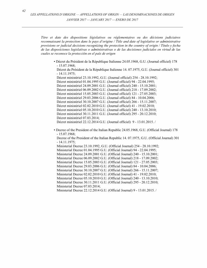
62 LES APPELLATIONS D’ORIGINE — APPELLATIONS OF ORIGIN — LAS DENOMINACIONES DE ORIGEN
JANVIER 2017 — JANUARY 2017 — ENERO DE 2017
Titre et date des dispositions législatives ou réglementaires ou des décisions judiciaires reconnaissant la protection dans le pays d’origine / Title and date of legislative or administrative provisions or judicial decisions recognizing the protection in the country of origin / Título y fecha de las disposiciones legislativas o administrativas o de las decisiones judiciales en virtud de las cuales se reconoce la protección en el país de origen
▪ Décret du Président de la République Italienne 24.05.1968, G.U. (Journal officiel) 178 - 15.07.1968;
Décret du Président de la République Italienne 14. 07.1975, G.U. (Journal officiel) 301 - 14.11.1975;
Décret ministériel 23.10.1992, G.U. (Journal officiel) 254 - 28.10.1992; Décret ministériel 01.04.1995 G.U. (Journal officiel) 94 - 22.04.1995; Décret ministériel 24.09.2001 G.U. (Journal officiel) 240 - 15.10.2001; Décret ministériel 06.09.2002 G.U. (Journal officiel) 218 - 17.09.2002; Décret ministériel 15.05.2003 G.U. (Journal officiel) 121 - 27.05.2003; Décret ministériel 29.03.2006 G.U. (Journal officiel) 84 - 10.04.2006; Décret ministériel 30.10.2007 G.U. (Journal officiel) 266 - 15.11.2007; Décret ministériel 02.02.2010 G.U. (Journal officiel) 41 - 19.02.2010; Décret ministériel 05.10.2010 G.U. (Journal officiel) 240 - 13.10.2010; Décret ministériel 30.11.2011 G.U. (Journal officiel) 295 - 20.12.2010; Décret ministériel 07.03.2014; Décret ministériel 22.12.2014 G.U. (Journal officiel) 9 - 13.01.2015. / ▪ Decree of the President of the Italian Republic 24.05.1968, G.U. (Official Journal) 178
- 15.07.1968; Decree of the President of the Italian Republic 14. 07.1975, G.U. (Official Journal) 301
- 14.11.1975; Ministerial Decree 23.10.1992, G.U. (Official Journal) 254 - 28.10.1992; Ministerial Decree 01.04.1995 G.U. (Official Journal) 94 - 22.04.1995; Ministerial Decree 24.09.2001 G.U. (Official Journal) 240 - 15.10.2001; Ministerial Decree 06.09.2002 G.U. (Official Journal) 218 - 17.09.2002; Ministerial Decree 15.05.2003 G.U. (Official Journal) 121 - 27.05.2003; Ministerial Decree 29.03.2006 G.U. (Official Journal) 84 - 10.04.2006; Ministerial Decree 30.10.2007 G.U. (Official Journal) 266 - 15.11.2007; Ministerial Decree 02.02.2010 G.U. (Official Journal) 41 - 19.02.2010; Ministerial Decree 05.10.2010 G.U. (Official Journal) 240 - 13.10.2010; Ministerial Decree 30.11.2011 G.U. (Official Journal) 295 - 20.12.2010; Ministerial Decree 07.03.2014; Ministerial Decree 22.12.2014 G.U. (Official Journal) 9 - 13.01.2015. /
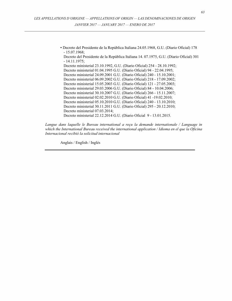
63
LES APPELLATIONS D’ORIGINE — APPELLATIONS OF ORIGIN — LAS DENOMINACIONES DE ORIGEN
JANVIER 2017 — JANUARY 2017 — ENERO DE 2017
▪ Decreto del Presidente de la República Italiana 24.05.1968, G.U. (Diario Oficial) 178
- 15.07.1968; Decreto del Presidente de la República Italiana 14. 07.1975, G.U. (Diario Oficial) 301
- 14.11.1975; Decreto ministerial 23.10.1992, G.U. (Diario Oficial) 254 - 28.10.1992; Decreto ministerial 01.04.1995 G.U. (Diario Oficial) 94 - 22.04.1995; Decreto ministerial 24.09.2001 G.U. (Diario Oficial) 240 - 15.10.2001; Decreto ministerial 06.09.2002 G.U. (Diario Oficial) 218 - 17.09.2002; Decreto ministerial 15.05.2003 G.U. (Diario Oficial) 121 - 27.05.2003; Decreto ministerial 29.03.2006 G.U. (Diario Oficial) 84 - 10.04.2006; Decreto ministerial 30.10.2007 G.U. (Diario Oficial) 266 - 15.11.2007; Decreto ministerial 02.02.2010 G.U. (Diario Oficial) 41 -19.02.2010; Decreto ministerial 05.10.2010 G.U. (Diario Oficial) 240 - 13.10.2010; Decreto ministerial 30.11.2011 G.U. (Diario Oficial) 295 - 20.12.2010; Decreto ministerial 07.03.2014; Decreto ministerial 22.12.2014 G.U. (Diario Oficial 9 - 13.01.2015.
Langue dans laquelle le Bureau international a reçu la demande internationale / Language in which the International Bureau received the international application / Idioma en el que la Oficina Internacional recibió la solicitud internacional
Anglais / English / Inglés
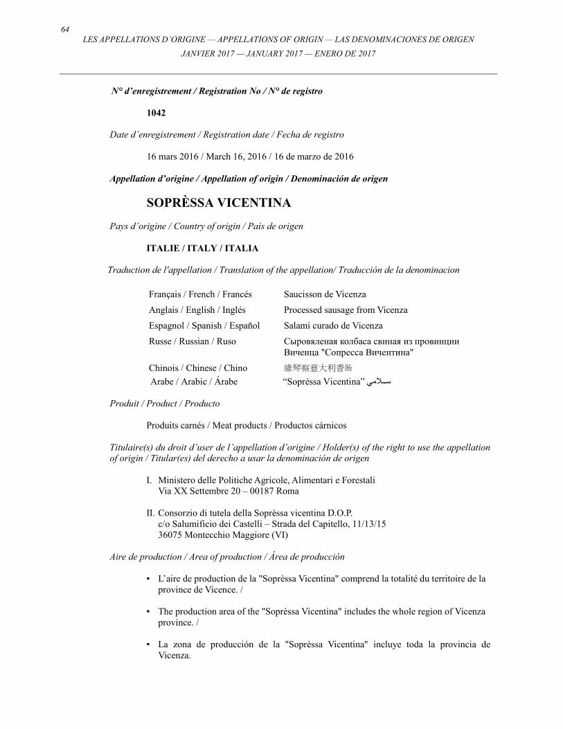
64 LES APPELLATIONS D’ORIGINE — APPELLATIONS OF ORIGIN — LAS DENOMINACIONES DE ORIGEN
JANVIER 2017 — JANUARY 2017 — ENERO DE 2017
N° d’enregistrement / Registration No / N° de registro
1042
Date d’enregistrement / Registration date / Fecha de registro
16 mars 2016 / March 16, 2016 / 16 de marzo de 2016
Appellation d’origine / Appellation of origin / Denominación de origen
SOPRÈSSA VICENTINA Pays d’origine / Country of origin / País de origen
ITALIE / ITALY / ITALIA
Traduction de l'appellation / Translation of the appellation/ Traducción de la denominacion
Français / French / Francés Saucisson de Vicenza
Anglais / English / Inglés Processed sausage from Vicenza
Espagnol / Spanish / Español Salami curado de Vicenza
Russe / Russian / Ruso Сыровяленая колбаса свиная из провинции Виченца "Сопресса Вичентина"
Chinois / Chinese / Chino 維琴察意大利香肠
Arabe / Arabic / Árabe “Soprèssa Vicentina” س����¡مي
Produit / Product / Producto
Produits carnés / Meat products / Productos cárnicos
Titulaire(s) du droit d’user de l’appellation d’origine / Holder(s) of the right to use the appellation of origin / Titular(es) del derecho a usar la denominación de origen
I. Ministero delle Politiche Agricole, Alimentari e Forestali Via XX Settembre 20 – 00187 Roma
II. Consorzio di tutela della Soprèssa vicentina D.O.P.
c/o Salumificio dei Castelli – Strada del Capitello, 11/13/15 36075 Montecchio Maggiore (VI)
Aire de production / Area of production / Área de producción
▪ L’aire de production de la "Soprèssa Vicentina" comprend la totalité du territoire de la province de Vicence. /
▪ The production area of the "Soprèssa Vicentina" includes the whole region of Vicenza
province. / ▪ La zona de producción de la "Soprèssa Vicentina" incluye toda la provincia de
Vicenza.
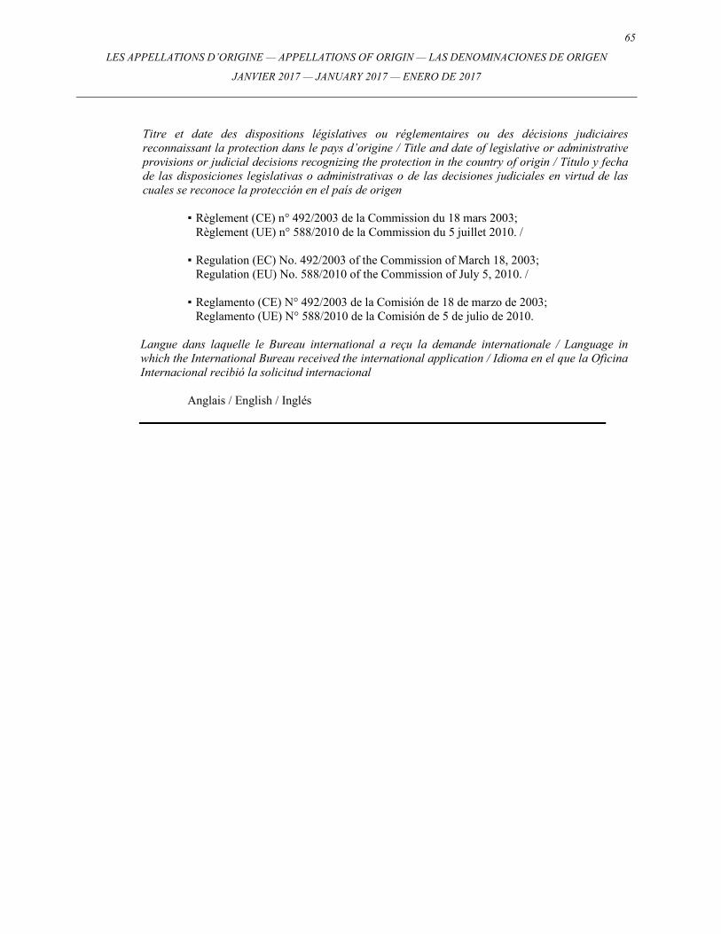
65
LES APPELLATIONS D’ORIGINE — APPELLATIONS OF ORIGIN — LAS DENOMINACIONES DE ORIGEN
JANVIER 2017 — JANUARY 2017 — ENERO DE 2017
Titre et date des dispositions législatives ou réglementaires ou des décisions judiciaires reconnaissant la protection dans le pays d’origine / Title and date of legislative or administrative provisions or judicial decisions recognizing the protection in the country of origin / Título y fecha de las disposiciones legislativas o administrativas o de las decisiones judiciales en virtud de las cuales se reconoce la protección en el país de origen
▪ Règlement (CE) n° 492/2003 de la Commission du 18 mars 2003; Règlement (UE) n° 588/2010 de la Commission du 5 juillet 2010. / ▪ Regulation (EC) No. 492/2003 of the Commission of March 18, 2003; Regulation (EU) No. 588/2010 of the Commission of July 5, 2010. / ▪ Reglamento (CE) N° 492/2003 de la Comisión de 18 de marzo de 2003; Reglamento (UE) N° 588/2010 de la Comisión de 5 de julio de 2010.
Langue dans laquelle le Bureau international a reçu la demande internationale / Language in which the International Bureau received the international application / Idioma en el que la Oficina Internacional recibió la solicitud internacional
Anglais / English / Inglés
66 LES APPELLATIONS D’ORIGINE — APPELLATIONS OF ORIGIN — LAS DENOMINACIONES DE ORIGEN
JANVIER 2017 — JANUARY 2017 — ENERO DE 2017
N° d’enregistrement / Registration No / N° de registro
1043
Date d’enregistrement / Registration date / Fecha de registro
17 mars 2016 / March 17, 2016 / 17 de marzo de 2016
Appellation d’origine / Appellation of origin / Denominación de origen
FORMAI DE MUT DELL’ALTA VAL BREMBANA Pays d’origine / Country of origin / País de origen
ITALIE / ITALY / ITALIA
Traduction de l'appellation / Translation of the appellation/ Traducción de la denominacion
Français / French / Francés Fromage de la Haute Vallée Brembana
Anglais / English / Inglés Cheese from the Alta Val Brembana
Espagnol / Spanish / Español Queso de la Alta Valle Brembana
Russe / Russian / Ruso Вареный прессованный сыр из цельного сырого коровьего молока «Формаи-де-Мут» высокогорной Альпийской долины Валь-Брембана»
Chinois / Chinese / Chino 布雷巴拉山谷羊乳酪
Arabe / Arabic / Árabe “Formai de Mut dell’Alta Val Brembana” جب�����ن
Produit / Product / Producto
Fromage / Cheese / Queso
Titulaire(s) du droit d’user de l’appellation d’origine / Holder(s) of the right to use the appellation of origin / Titular(es) del derecho a usar la denominación de origen
I. Ministero delle Politiche Agricole, Alimentari e Forestali Via XX Settembre 20 – 00187 Roma
II. Consorzio dei produttori per la tutela e la valorizzazione del Formai de Mut dell'Alta
Valle Brembana c/o C.C.I.A.A.- Largo Belotti 16 – 24121 Bergamo
67
LES APPELLATIONS D’ORIGINE — APPELLATIONS OF ORIGIN — LAS DENOMINACIONES DE ORIGEN
JANVIER 2017 — JANUARY 2017 — ENERO DE 2017
Aire de production / Area of production / Área de producción
▪ L’aire géographique de production et de maturation du fromage comprend l’intégralité du territoire administratif des communes citées ci-après, toutes appartenant à la Haute Vallée Brembana: Averara, Branzi, Carona, Camerata Cornello, Cassiglio, Cusio, Piazzatorre, Foppolo, Isola di Fondra, Lenna, Mezzoldo, Mio de’ Calvi, Olmo al Brembo, Ornica, Piazza Brembana, Piazzolo, Roncobello, Santa Brigida, Valleve, Valtorta, Valnegra. /
▪ The geographical area both of production and of the ripening of the cheese includes
the entire administrative territory of the municipalities below reported, all belongings to high Brembana Valley: Averara, Branzi, Carona, Camerata Cornello, Cassiglio, Cusio, Piazzatorre, Foppolo, Isola di Fondra, Lenna, Mezzoldo, Mio de’ Calvi, Olmo al Brembo, Ornica, Piazza Brembana, Piazzolo, Roncobello, Santa Brigida, Valleve, Valtorta, Valnegra. /
▪ La zona geográfica de producción y maduración del queso comprende la totalidad del
territorio administrativo de los municipios que figuran a continuación, todos ellos situados en el Valle de Brembana: Averara, Branzi, Carona, Camerata, Cornello, Cassiglio, Cusio, Piazzatorre, Foppolo, Isola di Fondra, Lenna, Mezzoldo, Moio de’ Calvi, Olmo al Brembo, Ornica, Piazza Brembana, Piazzolo, Roncobello, Santa Brigida, Valleve, Valtorta, Valnegra.
Titre et date des dispositions législatives ou réglementaires ou des décisions judiciaires reconnaissant la protection dans le pays d’origine / Title and date of legislative or administrative provisions or judicial decisions recognizing the protection in the country of origin / Título y fecha de las disposiciones legislativas o administrativas o de las decisiones judiciales en virtud de las cuales se reconoce la protección en el país de origen
▪ Règlement (CE) n° 1107/96 de la Commission du 12 juin 1996. / ▪ Regulation (CE) No. 1107/96 of the Commission of June 12, 1996. / ▪ Reglamento (CE) Nº 1107/96 de la Comisión de 12 de junio de 1996.
Langue dans laquelle le Bureau international a reçu la demande internationale / Language in which the International Bureau received the international application / Idioma en el que la Oficina Internacional recibió la solicitud internacional
Anglais / English / Inglés
68 LES APPELLATIONS D’ORIGINE — APPELLATIONS OF ORIGIN — LAS DENOMINACIONES DE ORIGEN
JANVIER 2017 — JANUARY 2017 — ENERO DE 2017
N° d’enregistrement / Registration No / N° de registro
1044
Date d’enregistrement / Registration date / Fecha de registro
17 mars 2016 / March 17, 2016 / 17 de marzo de 2016
Appellation d’origine / Appellation of origin / Denominación de origen
SALICE SALENTINO Pays d’origine / Country of origin / País de origen
ITALIE / ITALY / ITALIA
Traduction de l'appellation / Translation of the appellation/ Traducción de la denominacion
Français / French / Francés Salice Salentino
Anglais / English / Inglés Salice Salentino
Espagnol / Spanish / Español Salice Salentino
Russe / Russian / Ruso Вино Саличе Салентино
Chinois / Chinese / Chino 萨利切萨伦蒂诺
Arabe / Arabic / Árabe “Salice Salentino” نبي����������ذ
Produit / Product / Producto
Vin / Wine / Vino
Titulaire(s) du droit d’user de l’appellation d’origine / Holder(s) of the right to use the appellation of origin / Titular(es) del derecho a usar la denominación de origen
I. Ministero delle Politiche Agricole, Alimentari e Forestali Via XX Settembre 20 – 00187 Roma
II. Consorzio di tutela e valorizzazione del vino DOP Salice Salentino
Via P. Leone c/o casina Ripa – 73015 Salice Salentino (LE)
69
LES APPELLATIONS D’ORIGINE — APPELLATIONS OF ORIGIN — LAS DENOMINACIONES DE ORIGEN
JANVIER 2017 — JANUARY 2017 — ENERO DE 2017
Aire de production / Area of production / Área de producción
▪ Les raisins utilisés doivent être produits sur l’ensemble du territoire administratif de Salice Salentino, Veglie et Guagnano dans la province de Lecce; et sur l’ensemble du territoire administratif de San Pancrazio Salentino dans la province de Brindisi ainsi que sur une partie du territoire des communes de Campi Salentina dans la province de Lecce et Cellino San Marco dans la province de Brindisi.
Le territoire est ainsi délimité: partant de la route périphérique est de la ville de Campi Salentina, la délimitation suit, en direction du nord, la route vers Cellino San Marco. Elle traverse le centre-ville et continue en direction du nord le long de la route vers la ferme Blasi. Un kilomètre avant d’arriver à la ferme (au km 58), la délimitation tourne nord-ouest le long de la route qui, passant aux kilometres 57, 59 60 et 58, atteint la limite des communes de Brindisi et Cellino San Marco dans la localité de La Gaeta. Elle suit ensuite, en direction de l’ouest, la limite de la commune de Cellino San Marco, jusqu’au croisement avec la limite de Sandonaci qu’elle suit pour atteindre, en direction de l’ouest, la limite de San Pancrazio Salentino. La délimitation suit la limite de cette commune, d’abord en direction de l’ouest puis en direction du sud jusqu’au croisement avec la limite de Salice Salentino qu’elle suit en direction du sud puis de l’est, jusqu’à rencontrer la limite de Veglie. La délimitation se prolonge, en direction de l’est le long de la limite sud de Veglie, puis en direction du nord jusqu’à atteindre la limite de Campi Salentina dans la localité de Tornatola. Le long de la limite de Campi Salentina, la délimitation se prolonge, en direction du nord-est, et atteint la route nationale Salentina à proximité du km 59 puis, le long de cette route en direction de l’ouest, elle rejoint la route périphérique de la ville de Campi Salentina: le point de départ de la délimitation. /
▪ Grapes have to be produced in the entire administrative territory of Salice Salentino,
Veglie and Guagnano in the province of Lecce; and the entire administrative territory of San Pancrazio Salentino in the province of Brindisi as well as part of the territory in the municipalities of Campi Salentina in the province of Lecce and Cellino San Marco in the province of Brindisi.
The territory is thus delimited: starting from the east ring road of the town of Campi Salentina, the limit follows northwards the road to Cellino San Marco. It crosses the town center and continues northwards along the road to the Blasi farm. A kilometer before reaching the farm (at the km 58), the limit turns north-west along the road which, passing by the kilometers 57, 59, 60 and 58, reaches the border form the municipalities of Brindisi and Cellino San Marco, in the area of La Gaeta. It follows then westwards the municipal border of Cellino San Marco, up to crossing the border of Sandonaci and along the latter it reaches westwards the border of San Pancrazio Salentino. The limit follows the border of this municipality first westwards and then southwards up to crossing the border of Salice Salentino along which it follows southwards and then eastwards until meeting the border of Veglie. The limit follows eastwards along the south border of Veglie, and then northwards until reaching that of Campi Salentina in the area of Tornatola. Along the border of Campi Salentina, the limit follows northeastward and reaches the state road Salentina near the kilometer 59 and then, along this road, westwards, it reconnects to the ring road of the town of Campi Salentina: the starting point of the delimitation. /
70 LES APPELLATIONS D’ORIGINE — APPELLATIONS OF ORIGIN — LAS DENOMINACIONES DE ORIGEN
JANVIER 2017 — JANUARY 2017 — ENERO DE 2017
▪ Las uvas se producen en todo el territorio administrativo de Salice Salentino, Veglie y
Guagnano, en la provincial de Lecce, todo el territorio administrativo de San Pancrazio Salentino, en la provincia de Brindisi, así como parte del territorio de los municipios de Campi Salentina, en la provincia de Lecce y Cellino San Marco, en la provincia de Brindisi.
El territorio se delimita se la siguiente manera: el limite comienza desde la circunvalación este de la ciudad de Campi Salentina, y continúa hacia el norte por la carretera que lleva a Cellino San Marco. Atraviesa el centro de la ciudad y continúa hacia el norte siguiendo esta carretera hacia la granja Blasi. Un kilómetro antes de llegar a la granja (al km 58) gira hacia el noroeste, pasando los kilómetros 57, 59, 60 y 58, para alcanzar los límites de los municipios de Brindisi y Cellino San Marco, en la zona de La Gaeta. A continuación sigue hacia el oeste para alcanzar los limites del municipio de Cellino San Marco hasta cruzar los límites de Sandonaci, cruzando éste último para alcanzar al oeste los limites de San Pancrazio Salentino. El límite sigue la frontera de este municipio hacia el oeste, en primer término, para seguir hacia el sur y cruzar los límites de Salice Salentino, desde donde continúa hacia el sur, y luego al este hasta la frontera de Veglie. Sigue hacia el este a lo largo de la frontera sur de Veglie y después hacia el norte hasta llegar a la frontera de Campi Salentina en la zona de Tornatola. A lo largo de la frontera de Campi Salentina continúa hacia el norte hasta la carretera nacional Salentina, cerca del kilómetro 59, y después, siguiendo esta carretera hacia el oeste, vuelve a conectar con la circunvalación de la ciudad de Campi Salentina, el punto de partida de la delimitación.
Titre et date des dispositions législatives ou réglementaires ou des décisions judiciaires reconnaissant la protection dans le pays d’origine / Title and date of legislative or administrative provisions or judicial decisions recognizing the protection in the country of origin / Título y fecha de las disposiciones legislativas o administrativas o de las decisiones judiciales en virtud de las cuales se reconoce la protección en el país de origen
▪ Décret du Président de la République italienne 08.04.76 G.U. (Journal officiel) 224 - 25.08.76;
Décret du Président de la République italienne 06.12.90 G.U. (Journal officiel) 112 - 15.05.91;
Décret ministériel 08.10.2010 G.U. (Journal officiel) 248 - 22.10.2010; Décret ministériel 30.11.2011 G.U. (Journal officiel) 295 - 20.12.2011. /
▪ Decree of the President of the Italian Republic 08.04.76 G.U. (Official Journal) 224
- 25.08.76; Decree of the President of the Italian Republic 06.12.90 G.U. (Official Journal) 112 - 15.05.91; Ministerial Decree 08.10.2010 G.U. (Official Journal) 248 - 22.10.2010; Ministerial Decree 30.11.2011 G.U. (Official Journal) 295 - 20.12.2011. /
▪ Decreto del Presidente de la República Italiana 08.04.76 G.U. (Diario Oficial) 224 - 25.08.76; Decreto del Presidente de la República Italiana 06.12.90 G.U. (Diario Oficial) 112 - 15.05.91; Decreto Ministerial 08.10.2010 G.U. (Diario Oficial) 248 - 22.10.2010; Decreto Ministerial 30.11.2011 G.U. (Diario Oficial) 295 - 20.12.2011.

71
LES APPELLATIONS D’ORIGINE — APPELLATIONS OF ORIGIN — LAS DENOMINACIONES DE ORIGEN
JANVIER 2017 — JANUARY 2017 — ENERO DE 2017
Langue dans laquelle le Bureau international a reçu la demande internationale / Language in which the International Bureau received the international application / Idioma en el que la Oficina Internacional recibió la solicitud internacional
Anglais / English / Inglés
72 LES APPELLATIONS D’ORIGINE — APPELLATIONS OF ORIGIN — LAS DENOMINACIONES DE ORIGEN
JANVIER 2017 — JANUARY 2017 — ENERO DE 2017
N° d’enregistrement / Registration No / N° de registro
1045
Date d’enregistrement / Registration date / Fecha de registro
17 mars 2016 / March 17, 2016 / 17 de marzo de 2016
Appellation d’origine / Appellation of origin / Denominación de origen
BARBERA D’ASTI Pays d’origine / Country of origin / País de origen
ITALIE / ITALY / ITALIA
Traduction de l'appellation / Translation of the appellation/ Traducción de la denominacion
Français / French / Francés Barbera d’Asti
Anglais / English / Inglés Barbera d’Asti
Espagnol / Spanish / Español Barbera d’Asti
Russe / Russian / Ruso Барбера д'Асти
Chinois / Chinese / Chino 阿斯蒂巴贝拉
Arabe / Arabic / Árabe “Barbera d’Asti” نبي����������ذ
Produit / Product / Producto
Vin / Wine / Vino
Titulaire(s) du droit d’user de l’appellation d’origine / Holder(s) of the right to use the appellation of origin / Titular(es) del derecho a usar la denominación de origen
I. Ministero delle Politiche Agricole, Alimentari e Forestali Via XX Settembre 20 – 00187 Roma
II. Consorzio tutela Barbera d'Asti e Vini del Monferrato
Via Morelli 15 – 14100 Asti
73
LES APPELLATIONS D’ORIGINE — APPELLATIONS OF ORIGIN — LAS DENOMINACIONES DE ORIGEN
JANVIER 2017 — JANUARY 2017 — ENERO DE 2017
Aire de production / Area of production / Área de producción
▪ Province d’Asti: Agliano Terme, Albugnano, Antignano, Aramengo, Asti, Azzano d’Asti, Baldichieri, Belveglio, Berzano S. Pietro, Bruno, Bubbio, Buttigliera d’Asti, Calamandrana, Calliano, Calosso, Camerano Casasco, Canelli, Cantarana, Capriglio, Casorzo, Cassinasco, Castagnole Lanze, Castagnole Monferrato, Castel Boglione, Castell’Alfero, Castellero, Castelletto Molina, Castello d’Annone, Castelnuovo Belbo, Castelnuovo Calcea, Castelnuovo Don Bosco, Castel Rocchero, Celle Enomondo, Cerreto d’Asti, Cerro Tanaro, Cessole, Chiusano d’Asti, Cinaglio, Cisterna d’Asti, Coazzolo, Cocconato, Corsione, Cortandone, Cortanze, Cortazzone, Cortiglione, Cossombrato, Costigliole d’Asti, Cunico, Dusino San Michele, Ferrere, Fontanile, Frinco, Grana, Grazzano Badoglio, Incisa Scapaccino, Isola d’Asti, Loazzolo, Maranzana, Maretto, Moasca, Mombaldone, Mombaruzzo, Mombercelli, Monale, Monastero Bormida, Moncalvo, Moncucco Torinese, Mongardino, Montabone, Montafia, Montaldo Scarampi, Montechiaro d’Asti, Montegrosso d’Asti, Montemagno, Montiglio Monferrato, Moransengo, Nizza Monferrato, Olmo Gentile, Passerano Marmorito, Penango, Piea, Pino d’Asti, Piovà Massaia, Portacomaro, Quaranti, Refrancore, Revigliasco d’Asti, Roatto, Robella, Rocca d’Arazzo, Roccaverano, Rocchetta Palafea, Rocchetta Tanaro, San Damiano d’Asti, San Giorgio Scarampi, San Martino Alfieri, San Marzano Oliveto, San Paolo Solbrito, Scurzolengo, Serole, Sessame, Settime, Soglio, Tigliole, Tonco, Tonengo, Vaglio Serra, Valfenera, Vesime, Viale d’Asti, Viarigi, Vigliano, Villafranca d’Asti, Villa San Secondo, Vinchio.
Province d’Alessandria: Acqui, Alfiano Natta, Alice Bel Colle, Altavilla Monferrato,
Bergamasco, Bistagno, Borgoratto Alessandrino, Camagna Monferrato, Camino, Carentino, Casale Monferrato, Cassine, Castelletto Merli, Cellamonte, Cereseto, Cerrina, Coniolo, Conzano, Cuccaro Monferrato, Frascaro, Frassinello Monferrato, Fubine, Gabiano, Gamalero, Lu Monferrato, Mirabello Monferrato, Mombello Monferrato, Moncestino, Murisengo, Occimiano, Odalengo Grande, Odalengo Piccolo, Olivola, Ottiglio, Ozzano Monferrato, Pontestura, Ponzano Monferrato, Ricaldone, Rosignano Monferrato, Sala Monferrato, S. Giorgio Monferrato, S. Salvatore Monferrato, Serralunga di Crea, Solonghello, Strevi, Terruggia, Terzo, Treville, Vignale, Villadeati,Villamiroglio. Sur les communes de Coniolo, Casale Monferrato, Occimiano et Mirabello Monferrato l’aire de production se limite aux coteaux sur la rive droite du fleuve Pô, ces territoires étant délimités par la ceinture périphérique de Casale qui débouche du pont sur le Pô en direction d’Alessandria, longeant Colle S. Anna, traversant les environs de Valentino et le hameau de S. Germano.
L’aire de production du vin sous D.O.C.G. “Barbera d’Asti” supérieur “Nizza” couvre
l’ensemble de la région des communes suivantes: Agliano Terme, Belveglio, Calamandrana, Castel Boglione, Castelnuovo Belbo, Castelnuovo Calcea, Castel Rocchero, Cortiglione, Incisa Scapaccino, Mombaruzzo, Mombercelli, Nizza Monferrato, Vaglio Serra, Vinchio, Bruno, Rocchetta Palafea, Moasca, San Marzano Oliveto.
74 LES APPELLATIONS D’ORIGINE — APPELLATIONS OF ORIGIN — LAS DENOMINACIONES DE ORIGEN
JANVIER 2017 — JANUARY 2017 — ENERO DE 2017
L’aire de production du vin sous D.O.C.G. “Barbera d’Asti” supérieur “Tinella” couvre
l’ensemble de la région des communes de: Costigliole d’Asti, Calosso, Castagnole Lanze, Coazzolo, Isola d'Asti (aire limitée à la région située à la droite de la route Asti – Monegrosso).
L’aire de production du vin sous D.O.C.G. “Barbera d’Asti” supérieur “Colli Astiani”
ou “Astiano” couvre, pour la commune d’Asti, le district de Montemarzo et S. Marzanotto Valle Tanaro, pour la commune d'Isola d'Asti, le territoire situé à gauche de la route Asti – Montegrosso et l’ensemble de la région des communes de Mongardino, Vigliano, Monegrosso d'Asti, Montaldo Scarampi, Rocca d'Arazzo, Azzano. /
▪ Province of Asti: Agliano Terme, Albugnano, Antignano, Aramengo, Asti, Azzano
d'Asti, Baldichieri, Belveglio, Berzano S. Pietro, Bruno, Bubbio, Buttigliera d' Asti, Calamandrana, Calliano, Calosso, Camerano Casasco, Canelli, Cantarana, Capriglio, Casorzo, Cassinasco, Castagnole Lanze, Castagnole Monferrato, Castel Boglione, Castell'Alfero, Castellero, Castelletto Molina, Castello d'Annone, Castelnuovo Belbo, Castelnuovo Calcea, Castelnuovo Don Bosco, Castel Rocchero, Celle Enomondo, Cerreto d' Asti, Cerro Tanaro, Cessole, Chiusano d'Asti, Cinaglio, Cisterna d'Asti, Coazzolo, Cocconato, Corsione, Cortandone, Cortanze, Cortazzone, Cortiglione, Cossombrato, Costigliole d'Asti, Cunico, Dusino San Michele, Ferrere, Fontanile, Frinco, Grana, Grazzano Badoglio, Incisa Scapaccino, Isola d' Asti, Loazzolo, Maranzana, Maretto, Moasca, Mombaldone, Mombaruzzo, Mombercelli, Monale, Monastero Bormida, Moncalvo, Moncucco Torinese, Mongardino, Montabone, Montafia, Montaldo Scarampi, Montechiaro d'Asti, Montegrosso d'Asti, Montemagno, Montiglio Monferrato, Moransengo, Nizza Monferrato, Olmo Gentile, Passerano Marmorito, Penango, Piea, Pino d'Asti, Piova Massaia, Portacomaro, Quaranti, Refrancore, Revigliasco d' Asti, Roatto, Robella, Rocca d'Arazzo, Roccaverano, Rocchetta Palafea, Rocchetta Tanaro, San Damiano d'Asti, San Giorgio Scarampi, San Martino Alfieri, San Marzano Oliveto, San Paolo Solbrito, Scurzolengo, Serole, Sessame, Settime, Soglio, Tigliole, Tonco, Tonengo, Vaglio Serra, Valfenera, Vesime, Viale d' Asti, Viarigi, Vigliano, Villafranca d' Asti, Villa San Secondo, Vinchio.
Province of Alessandria: Acqui, Alfiano Natta, Alice Bel Colle, Altavilla Monferrato,
Bergamasco, Bistagno, Borgoratto Alessandrino, Camagna Monferrato, Camino, Carentino, Casale Monferrato, Cassine, Castelletto Merli, Cellamonte, Cereseto, Cerrina, Coniolo, Conzano, Cuccaro Monferrato, Frascaro, Frassinello Monferrato, Fubine, Gabiano, Gamalero, Lu Monferrato, Mirabello Monferrato, Mombello Monferrato, Moncestino, Murisengo, Occimiano, Odalengo Grande, Odalengo Piccolo, Olivola, Ottiglio, Ozzano Monferrato, Pontestura, Ponzano Monferrato, Ricaldone, Rosignano Monferrato, Sala Monferrato, S. Giorgio Monferrato, S. Salvatore Monferrato, Serralunga di Crea, Solonghello, Strevi, Terruggia, Terzo, Treville, Vignale, Villadeati, Villamiroglio. In the municipalities of Coniolo, Casale Monferrato, Occimiano and Mirabello Monferrato the production area is limited to the hill terrains on the right of the Po river and which are delimited by the Casale ring road which exits from the bridge on Po towards Alessandria, skirting Colle S. Anna, crossing the neighbourhood of Valentino and the hamlet of S. Germano.
75
LES APPELLATIONS D’ORIGINE — APPELLATIONS OF ORIGIN — LAS DENOMINACIONES DE ORIGEN
JANVIER 2017 — JANUARY 2017 — ENERO DE 2017
The production area of D.O.C.G. wine "Barbera d'Asti" superior "Nizza" includes the whole region of the following municipalities: Agliano Terme, Belveglio, Calamandrana, Castel Boglione, Castelnuovo Belbo, Castelnuovo Calcea, Castel Rocchero, Cortiglione, Incisa Scapaccino, Mombaruzzo, Mombercelli, Nizza Monferrato, Vaglio Serra, Vinchio, Bruno, Rocchetta Palafea, Moasca, San Marzano Oliveto. The production area of D.O.C.G. wine "Barbera d'Asti" superior "Tinella" includes the whole region of the municipalities of : Costigliole d'Asti, Calosso, Castagnole Lanze, Coazzolo, Isola d'Asti (with limitation to the region located right-hand of the Asti-Monegrosso road).
The production area of D.O.C.G. wine "Barbera d'Asti" superior "Calli Astiani" or "Astiano" includes for the municipality of Asti the district Montemarzo and S. Marzanotto Valle Tanaro, for the municipality of Isola d'Asti, the region left-hand of the Asti – Monegrosso road and the whole region of the municipalities of Mongardino, Vigliano, Montegrosso d'Asti, Montaldo Scarampi, Rocca d'Arazzo, Azzano. /
▪ Provincia de Asti: Agliano Terme, Albugnano, Antignano, Aramengo, Asti, Azzano
d’Asti, Baldichieri, Belveglio, Berzano S. Pietro, Bruno, Bubbio, Buttigliera d’Asti, Calamandrana, Calliano, Calosso, Camerano Casasco, Canelli, Cantarana, Capriglio, Casorzo, Cassinasco, Castagnole Lanze, Castagnole Monferrato, Castel Boglione, Castell’Alfero, Castellero, Castelletto Molina, Castello d’Annone, Castelnuovo Belbo, Castelnuovo Calcea, Castelnuovo Don Bosco, Castel Rocchero, Celle Enomondo, Cerreto d’Asti, Cerro Tanaro, Cessole, Chiusano d’Asti, Cinaglio, Cisterna d’Asti, Coazzolo, Cocconato, Corsione, Cortandone, Cortanze, Cortazzone, Cortiglione, Cossombrato, Costigliole d’Asti, Cunico, Dusino San Michele, Ferrere, Fontanile, Frinco, Grana, Grazzano Badoglio, Incisa Scapaccino, Isola d’Asti, Loazzolo, Maranzana, Maretto, Moasca, Mombaldone, Mombaruzzo, Mombercelli, Monale, Monastero Bormida, Moncalvo, Moncucco Torinese, Mongardino, Montabone, Montafia, Montaldo Scarampi, Montechiaro d’Asti, Montegrosso d’Asti, Montemagno, Montiglio Monferrato, Moransengo, Nizza Monferrato, Olmo Gentile, Passerano Marmorito, Penango, Piea, Pino d’Asti, Piovà Massaia, Portacomaro, Quaranti, Refrancore, Revigliasco d’Asti, Roatto, Robella, Rocca d’Arazzo, Roccaverano, Rocchetta Palafea, Rocchetta Tanaro, San Damiano d’Asti, San Giorgio Scarampi, San Martino Alfieri, San Marzano Oliveto, San Paolo Solbrito, Scurzolengo, Serole, Sessame, Settime, Soglio, Tigliole, Tonco, Tonengo, Vaglio Serra, Valfenera, Vesime, Viale d’Asti, Viarigi, Vigliano, Villafranca d’Asti, Villa San Secondo, Vinchio.
Provincia de Alessandria: Acqui, Alfiano Natta, Alice Bel Colle, Altavilla Monferrato,
Bergamasco, Bistagno, Borgoratto Alessandrino, Camagna Monferrato, Camino, Carentino, Casale Monferrato, Cassine, Castelletto Merli, Cellamonte, Cereseto, Cerrina, Coniolo, Conzano, Cuccaro Monferrato, Frascaro, Frassinello Monferrato, Fubine, Gabiano, Gamalero, Lu Monferrato, Mirabello Monferrato, Mombello Monferrato, Moncestino, Murisengo, Occimiano, Odalengo Grande, Odalengo Piccolo, Olivola, Ottiglio, Ozzano Monferrato, Pontestura, Ponzano Monferrato, Ricaldone, Rosignano Monferrato, Sala Monferrato, S. Giorgio Monferrato, S. Salvatore Monferrato, Serralunga di Crea, Solonghello, Strevi, Terruggia, Terzo, Treville, Vignale, Villadeati, Villamiroglio. En las municipalidades de Coniolo, Casale Monferrato, Occiamiano y Mirabello Monferrato la zona de producción se limita a los
76 LES APPELLATIONS D’ORIGINE — APPELLATIONS OF ORIGIN — LAS DENOMINACIONES DE ORIGEN
JANVIER 2017 — JANUARY 2017 — ENERO DE 2017
terrenos montañosos sobre el margen derecho del río Po y que están delimitados por la
circunvalación de Casale que empieza en el puente sobre el río Po en dirección de Alessandria, circundan Colle S. Anna, atraviesan los alrededores de Valentino y el caserío de S. Germano.
El área de producción del vino con la D.O.C.G. “Barbera d’Asti” superior “Nizza”
abarca todo el territorio de las siguientes municipalidades: Agliano Terme, Belveglio, Calamandrana, Castel Boglione, Castelnuovo Belbo, Castelnuovo Calcea, Castel Rocchero, Cortiglione, Incisa Scapaccino, Mombaruzzo, Mombercelli, Nizza Monferrato, Vaglio Serra, Vinchio, Bruno, Rocchetta Palafea, Moasca, San Marzano Oliveto.
El área de producción del vino con la D.O.C.G. “Barbera d’Asti” superior “Tinella”
abarca toda la región de las municipalidades de: Costigliole d’Asti, Calosso, Castagnole Lanze, Coazzolo, Isola d’Asti (que se limita a la región situada a la derecha de la carretera Asti-Monegrosso).
El área de producción del vino con la D.O.C.G. “Barbera d’Asti” superior “Colli
Astiani” o “Astiano” abarca, para la municipalidad de Asti, el distrito Montemarzo y S. Marzanotto Valle Tanaro, para la municipalidad de Isola d’Asti, el territorio situado a la izquierda de la carretera Asti-Monegrosso y la totalidad de las municipalidades de Mongardino, Vigliano, Monegrosso d’Asti, Montaldo Scarampi, Rocca d’Azzaro, Azzano.
Titre et date des dispositions législatives ou réglementaires ou des décisions judiciaires reconnaissant la protection dans le pays d’origine / Title and date of legislative or administrative provisions or judicial decisions recognizing the protection in the country of origin / Título y fecha de las disposiciones legislativas o administrativas o de las decisiones judiciales en virtud de las cuales se reconoce la protección en el país de origen
▪ Décret du Président de la République italienne 09.01.1970 G.U. (Journal officiel) 73 - 23.03.1970;
Décret ministériel 08.07.08 G.U. (Journal officiel) 169 - 21.07.2008; Décret ministériel 17.09.2010 G.U. (Journal officiel) 236 - 08.10.2010; Décret ministériel 30.11.2011 G.U. (Journal officiel) 295 - 20.12.2011. ▪ Decree of the President of the Italian Republic 09.01.1970 G.U. (Official Journal) 73
- 23.03.1970; Ministerial Decree 08.07.08 G.U. (Official Journal) 169 - 21.07.2008; Ministerial Decree 17.09.2010 G.U. (Official Journal) 236 - 08.10.2010; Ministerial Decree 30.11.2011 G.U. (Official Journal) 295 - 20.12.2011. / ▪ Decreto del Presidente de la República Italiana 09.01.1970 G.U. (Diario Oficial) 73
- 23.03.1970; Decreto Ministerial 08.07.08 G.U. (Diario Oficial) 169 - 21.07.2008; Decreto Ministerial 17.09.2010 G.U. (Diario Oficial) 236 - 08.10.2010; Decreto Ministerial 30.11.2011 G.U. (Diario Oficial) 295 - 20.12.2011.
77
LES APPELLATIONS D’ORIGINE — APPELLATIONS OF ORIGIN — LAS DENOMINACIONES DE ORIGEN
JANVIER 2017 — JANUARY 2017 — ENERO DE 2017
Langue dans laquelle le Bureau international a reçu la demande internationale / Language in which the International Bureau received the international application / Idioma en el que la Oficina Internacional recibió la solicitud internacional
Anglais / English / Inglés
78 LES APPELLATIONS D’ORIGINE — APPELLATIONS OF ORIGIN — LAS DENOMINACIONES DE ORIGEN
JANVIER 2017 — JANUARY 2017 — ENERO DE 2017
N° d’enregistrement / Registration No / N° de registro
1046
Date d’enregistrement / Registration date / Fecha de registro
17 mars 2016 / March 17, 2016 / 17 de marzo de 2016 Appellation d’origine / Appellation of origin / Denominación de origen
SANNIO Pays d’origine / Country of origin / País de origen
ITALIE / ITALY / ITALIA
Traduction de l'appellation / Translation of the appellation/ Traducción de la denominacion
Français / French / Francés Sannio
Anglais / English / Inglés Sannio
Espagnol / Spanish / Español Sannio
Russe / Russian / Ruso Вино Саннио
Chinois / Chinese / Chino 德尔桑尼奥
Arabe / Arabic / Árabe “Sannio” نبي����������ذ Produit / Product / Producto
Vin / Wine / Vino
Titulaire(s) du droit d’user de l’appellation d’origine / Holder(s) of the right to use the appellation of origin / Titular(es) del derecho a usar la denominación de origen
I. Ministero delle Politiche Agricole, Alimentari e Forestali Via XX Settembre 20 – 00187 Roma
II. Sannio Consorzio Tutela Vini
Via Mario Vetrone, snc – 82100 Benevento
Aire de production / Area of production / Área de producción ▪ 3.1) L’aire où sont récoltés les raisins destinés à la production du vin bénéficiant de
l’Appellation d’Origine contrôlée "Sannio" comprend l’ensemble du territoire administratif de la province de Benevento, tel que stipulé dans le décret ministériel du 5 août 1997 publié au Journal officiel n° 204 le 2 septembre 1997.
79
LES APPELLATIONS D’ORIGINE — APPELLATIONS OF ORIGIN — LAS DENOMINACIONES DE ORIGEN
JANVIER 2017 — JANUARY 2017 — ENERO DE 2017
3.2) Délimitation de la sous-zone de "Guardia Sanframondi" ou "Guardiolo". L’aire où
sont cultivés les raisins comprend l’ensemble du territoire administratif des communes de Guardia Sanframondi, San Lorenzo Maggiore, San Lupo et Castelvenere dans la province de Benevento, tel que stipulé dans le décret ministériel du 2 août 1993 publié au Journal officiel n° 193 le 18 août 1993.
3.3) Délimitation de la sous-zone de "Sant’Agata dei Goti". L’aire où sont cultivés les
raisins comprend l’ensemble du territoire administratif de la commune de Sant’Agata dei Goti dans la province de Benevento, tel que stipulé dans le décret ministériel du 3 août 1993 publié au Journal officiel n°196 le 21 août 1993.
3.4) Délimitation de la sous-zone de "Solopaca". L’aire où sont cultivés les raisins
comprend l’ensemble du territoire administratif des communes de Solopaca, Castelvenere, Guardia Sanframondi, San Lorenzo Maggiore, et une partie des communes de Cerreto Sannita, Faicchio, Frasso Telesino, Melizzano, San Lorenzello, San Salvatore Telesino, Telese et Vitulano, toutes situées dans la province de Benevento, tel que stipulé dans le décret ministériel du 20.09.1973 modifié par le décret ministériel du 12.10.1992 et par le décret ministériel du 30.10.2002 publié dans le Journal officiel n° 271 le 19 novembre 2002. Cette aire est délimitée comme suit: partant du point d’intersection entre les limites des communes de San Lorenzo Maggiore, Guardia Sanframondi, San Lupo et Cerreto Sannita au niveau de Ripa del Corvo, la ligne de délimitation suit, dans un premier temps, la limite est puis la limite sud de San Lorenzo Maggiore en direction du sud, jusqu’à rencontrer la limite de Vitulano qu’elle suit en direction du sud sud-est jusqu’au chemin muletier à 349 m d’altitude, qu’elle suit en direction du sud-ouest et à 305 m d’altitude, elle rejoint le chemin menant vers l’ouest, atteignant 272, 162, 165 et 219 m, où elle rejoint la limite de la commune de Solopaca qu’elle suit vers le sud puis vers l’ouest jusqu’à atteindre la limite de Melizzano qu’elle suit vers l’ouest jusqu’au village d’Acquaviva où elle traverse la route de Solopaca Frasso Telesino. Elle suit la route vers Sant’Agata dei Goti jusqu’au pont à proximité de Masseria Calabrese à 315 m d’altitude. De là, suivant le cours d’eau en direction du sud, elle atteint la limite sud de Frasso Telesino qu’elle suit vers l’ouest puis vers le nord jusqu’à la route de Dugenta-Frasso Telesino qu’elle longe en direction du nord jusqu’à environ 165 m d’altitude, où, une nouvelle fois, elle suit la route, se dirige vers le sud sur environ 100 m pour ensuite, prendre la route en direction de l’ouest à 74 m d’altitude, à Torre Maiorano, à presque 39 m d’altitude, elle atteint la route Dugenta-Telese et la suit en direction de l’est longeant la route menant à Piana qu’elle borde, partant vers l’ouest de ce hameau jusqu’à atteindre le chemin de terre à 72 m d’altitude. De là, la délimitation court en ligne droite puis, après avoir passé le torrent Maltempo, elle atteint le bâtiment portant l’enseigne d’une usine sur la route menant à Melizzano. Depuis ce point, elle suit cette route en direction du nord-ouest, jusqu’à rencontrer la route de Dugenta-Telese qu’elle suit jusqu’au pont de Calce d’où elle continue en direction de l’est le long de la limite de la commune de Solopaca, jusqu’à atteindre, à Pagnano, la chaussée délimitant le hameau de Santo Frate vers le nord. Elle suit cette route vers l’ouest sur environ 1,250 km puis bifurque vers le nord le long de la crête à 45 et 52 m d’altitude, jusqu’à atteindre, après 52 m, la voie ferrée qui traverse la ville de Telese en direction du nord. Elle suit ensuite la route qui, en direction de l’est, croise les limites de la commune de Castelvenere, puis vers le nord jusqu’à rencontrer la route de Massa La Grotta. Depuis cette jonction, la ligne de délimitation continue vers le nord-ouest le long du chemin qui à 114 et 112 m atteint la route menant à la pierre de carrière à 112 m, elle la suit sur environ 350 m, puis en direction du nord, suit le chemin qui se déroule sur les pentes

80 LES APPELLATIONS D’ORIGINE — APPELLATIONS OF ORIGIN — LAS DENOMINACIONES DE ORIGEN
JANVIER 2017 — JANUARY 2017 — ENERO DE 2017
de la colline Della Rocca et à travers Vigne Vecchie, elle atteint la route menant à
Massa, à 162 m d’altitude, puis poursuit sa course en direction du nord le long de cette route pratiquement jusqu’à Massa, au carrefour avec la route qui mène à Masseria (gîte rural) del Barone, suivant la route qui contourne la ville vers l’ouest, atteignant ainsi les rives du torrent Titerno. Elle suit les rives de ce cours d’eau en direction de l’est jusqu’à rencontrer la limite de la commune de Cerreto Sannita, suivant la rive gauche du torrent Titerno, puis vers le sud de Cerreto Sannita jusqu’au chemin qui rejoint la route menant au couvent des capucins près des ruines. Après avoir traversé le chemin, la ligne de délimitation le suit vers le sud bordant les hameaux de Lomia di Spita et Cesine di Sopra passant par les points d’altitude 380, 424, 425, 433, 415, 417 et 379; elle atteint la limite communale de Guardia Sanframondi qu’elle suit en direction de l’est, à proximité de Ripe del Corvo, atteignant le point d’intersection des limites communales à l’endroit où la ligne de délimitation a démarré.
3.5) Délimitation de la sous-zone de "Solopaca Classico". Les raisins utilisés pour
produire les vins AOC "Sannio" de la sous-zone "Solopaca Classico" doivent être produits dans la commune de Solopaca uniquement et sur un territoire délimité comme suit : partant du pont qui enjambe la rivière Calore "Maria Cristina" dans le hameau de "Fontana Sala", la ligne de délimitation suit la route provinciale de Bebiana en direction de l’ouest, jusqu’à atteindre 64 m d’altitude au-dessus du niveau de la mer, puis elle tourne à droite, suit un grand chemin d’herbe sur environ 100 m jusqu’à atteindre une différence d’altitude naturelle; elle suit la marge supérieure toujours en direction de l’ouest, jusqu’à atteindre la route communale dans la ville de Vatecupo puis elle suit cette route, toujours en direction de l’ouest, traversant Abbamondi à 67 m jusqu’à Ferri à 79 m; de là, elle suit le chemin en direction de l’ouest jusqu’à 55 m, rejoignant la route communale de S. Pietro et encore vers le nord-ouest à 55 m d’altitude puis 50 m jusqu’à la jonction formée par la route communale avec un chemin menant vers le sud; à ce point, elle suit la marge supérieure du talus naturel, toujours vers l’ouest, elle passe la route communale dans la ville d’Arena et suit le talus jusqu’à Varriciello, elle atteint la route communicale de Procaccia; elle rejoint cette route puis la suit en direction de l’ouest jusqu’à arriver à via Bebiana où elle continue jusqu’à atteindre la limite communale de Solopaca, à Ponte della Calce. Depuis ce point, elle continue le long de la limite communale en direction du sud-est, à 152, 179 et 181 m d’altitude et au niveau de la ville de S. Vincenzo, elle coupe la route provinciale venant de Frasso Telesino, puis la suit en direction de l’est, vers Solopaca, jusqu’à 212 m; à ce point elle emprunte la grande route sur la droite puis tourne immédiatement à gauche, suit le chemin muletier, atteint l’étang puis continue le long du chemin muletier après l’étang, elle tourne à droite jusqu’à atteindre à 332 m Gesucristiello, puis elle tourne une nouvelle fois à droite en suivant encore le chemin muletier à 282 et 228 m d’altitude, puis amorce sa descente en direction du nord, bifurque à droite suivant la différence d’altitude naturelle à proximité des maisons, elle continue en direction de l’est, à 196 et 197 m d’altitude et toujours en direction de l’est, elle atteint le chemin muletier arrivant de 201 m à environ 50 m de là ; elle continue en direction de l’est à 214, 268, 273, 265 et jusqu’à 404 m d’altitude, jusqu’à la limite entre Solopaca et Vitulano; suivant la limite communale, la ligne de délimitation descend vers le nord, elle atteint la route venant de Paupisi; elle tourne à gauche en direction de la ville de Solopaca, jusqu’à rejoindre une grande route sur la droite après 86 m, atteignant le chemin à 62, 62 et 76 m d’altitude au niveau du hameau de Campaminico, arrivant à 82 m au-dessus du niveau de la mer; depuis ce point, elle descend à 60 m puis suit le chemin en direction de l’ouest jusqu’à atteindre le pont Maria Cristina, son point de départ.
81
LES APPELLATIONS D’ORIGINE — APPELLATIONS OF ORIGIN — LAS DENOMINACIONES DE ORIGEN
JANVIER 2017 — JANUARY 2017 — ENERO DE 2017
3.6) Délimitation de la sous-zone "Taburno". L’aire où sont cultivés les raisins
comprend l’ensemble du territoire administratif des communes de Apollosa, Bonea, Campoli del Monte Taburno, Castelpoto, Foglianise, Montesarchio, Paupisi, Torrecuso et Ponte ainsi qu’une partie du territoire des communes de Benevento, Cautano, Vitulano et Tocco Caudio, toutes dans la province de Benevento, tel que stipulé dans le Décret présidentiel du 29.10.1986, remplacé par le Décret ministériel du 2 août 1993 publié dans le Journal officiel n°201 le 27 août 1993. Cette aire est délimitée comme suit: partant de la limite entre les communes de Apollosa et Benevento, et plus spécifiquement au km 256 de la rue Appia sur la route nationale n°7, la ligne de délimitation va en direction du nord, elle suit le torrent Serretelle jusqu’à rencontrer la rivière Calore. Elle suit cette limite sur 2 km environ jusqu’à rencontrer la ligne de chemin de fer Benevento – Caserta qu’elle suit en direction de l’est jusqu’à la route nationale SS n° 88 Dei Due Principati qu’elle suit jusqu’à la limite de la commune de Torrecuso à 248 m d’altitude. Elle suit cette limite une nouvelle fois, bifurquant vers l’est au km 80 de cette route nationale SS n° 88 puis longe la limite communale en direction de l’ouest, pratiquement toujours sur la route nationale, jusqu’à rencontrer la limite de la commune de Ponte. Elle suit la limite communale de Paupisi jusqu’à la limite de la commune de Torrecuso à 720 m d’altitude. Elle suit une courte portion de la limite communale de Torrecuso jusqu’à Monte S. Michele dans la commune de Foglianise. Longeant cette limite, elle arrive alors au torrent S. Menna puis remonte se dernier jusqu’à Madonna degli Angeli à 582 m d’altitude sur 3 km bordant la commune de Vitulano. Dans le hameau de S. Giuseppe, la ligne de délimitation continue le long de la route reliant Fuschi di Sotto, casale Resi et casale Tammari, elle tourne vers le sud à Fontana Reale et suit le torrent Palillo jusqu’à rencontrer la limite de la commune de Cautano. Toujours en direction du sud, la ligne de délimitation traverse la route provinciale de Vitulanese, la première section, à 291 m d’altitude, rejoint le torrent Ienca puis, plus loin, traverse la route communale de Luciarco à 282 m d’altitude. Elle suit cette route sur 10 km environ jusqu’à la limite de la commune de Campoli del Monte Taburno au niveau de la route provinciale de Vitulanese à 423 m d’altitude. De là, la ligne de délimitation longe les limites de Campoli del Monte Taburno jusqu’à 502 m avant de rejoindre la route communale de Cesine dans la commune de Tocco Caudio qu’elle suit sur une courte distance jusqu’à la route provinciale de Friuni dans la même commune. Suivant la route provinciale de Friuni, la ligne de délimitation se dirige vers le sud jusqu’à rejoindre le torrent Castagnola puis elle traverse la route communale de Casino-Friuni à 559 m d’altitude. Partant de ce point, elle descend, toujours en suivant la limite communale de Campoli del Monte Taburno, puis traverse la limite communale de Montesarchio à Sperata. Suivant la route communale de Montesarchio, elle traverse Bonea au hameau de Sorgente Rivullo. Depuis là, la ligne de délimitation suit la limite de la commune de Bonea jusqu’à traverser une nouvelle fois la limite de Montesarchio à 269 m d’altitude à proximité de la route nationale SS n° 7. Elle suit les limite de la commune de Montecharchio jusqu’à Tufara Valle, elle atteint la limite d’Apollosa jusqu’au point où elle revient à son point de départ. A cette délimitation d’aire, il convient d’ajouter une petite aire indépendante appartenant à la commune de Tocco Caudio et délimitée comme suit: partant du cimetière de Tocco Caudio et en direction du nord, la ligne court vers la circonscription de Sala et suit la limite est délimitant les municipalités de Cautano et Tocco Caudio, elle rejoint la route communale de Maione et la suit jusqu’au torrent Tassi. Elle suit ce torrent jusqu’à S. Cosimo Church à 752 m d’altitude où la ligne de délimitation continue en direction de l’ouest jusqu’au torrent Ienca qu’elle suit pour redescendre jusqu’au cimetière qui est le point de départ. /
82 LES APPELLATIONS D’ORIGINE — APPELLATIONS OF ORIGIN — LAS DENOMINACIONES DE ORIGEN
JANVIER 2017 — JANUARY 2017 — ENERO DE 2017
▪ 3.1) The area where grapes are picked to make wine for the "Sannio" Controlled
Designation of Origin includes the entire administrative area of the province of Benevento, as demarcated by means of ministerial decree of 5 August 1997 published in Official Gazette n° 204 on 2 September 1997.
3.2) Demarcation of the "Guardia Sanframondi" or "Guardiolo" sub-zone. The area
where the grapes are grown includes the entire administrative territory of the municipalities of Guardia Sanframondi, San Lorenzo Maggiore, San Lupo and Castelvenere in the province of Benevento, as already demarcated by means of Ministerial Decree of 2 August 1993 published in the Official Gazette No. 193 on 18 August 1993.
3.3) Demarcation of the "Sant'Agata dei Goti" sub-zone. The area where the grapes are
grown includes the entire administrative territory of the municipalities of Sant'Agata dei Goti in the province of Benevento, as already demarcated by means of Ministerial Decree of 3 August 1993 published in the official Gazette No. 196 on 21 August 1993.
3.4) Demarcation of the "Solopaca" sub-zone. The area where the grapes are grown
includes the entire administrative territory of the municipalities of Solopaca, Castelvenere, Guardia Sanframondi, San Lorenzo Maggiore and part of the municipalities of Cerreto Sannita, Faicchio, Frasso Telesino, Melizzano, San Lorenzello, San Salvatore Telesino, Telese and Vitulano, all in the province of Benevento, as already demarcated by means of Presidential Decree 20.09.1973 amended by means of Ministerial Decree 12.10.1992 and Ministerial Decree 30.10.2002 published in the Official Gazette No. 271 of 19 November 2002. This area is demarcated in the following manner: starting from the point where the municipal boundaries of San Lorenzo Maggiore, Guardia Sanframondi, San Lupo and Cerreto Sannita intersect at Ripe del Corvo, the demarcation line follows the eastern boundary first and then the southern boundary of San Lorenzo Maggiore in a southerly direction, until it meets the boundary of Vitulano which it follows in a south south-easterly direction until it meets the mule track at a height of 349 m which it follows in a south-westerly direction and at a height of 305 m it joins the path, heading west, reaching 272, 162, 165 and 219 m, where it meets the boundary of the municipality of Solopaca and follows it south and then west until it comes to the boundary of Melizzano which it follows west until the village of Acquaviva where it crosses the Solopaca Frasso Telesino road. It follows the road to Sant'Agata dei Goti up to the bridge near Masseria Calabrese at a height of 315 m. From here, following the watercourse southwards, it reaches the southern boundary of Frasso Telesino, follows it west and then north up to the Dugenta – Frasso Telesino Road which it runs along in a northerly direction until close to a height of 165 m where, again following the road, it heads south for around 100 m until, in a westerly direction, it takes the road which at a height of 74 m, at Torre Maiorano, near to 39 m, reaches the Dugenta – Telese Road, following this eastwards along the road leading to Piana which it skirts, going to the west of this hamlet until it reaches the dirt track at a height of 72 m. From here, it goes in a straight line and once it has passed the Maltempo torrent, reaches the building marked with the sign of a factory on the road leading to Melizzano. From this point, it follows this road northwest until it meets the Dugenta – Telese Road, following it up to the Calce bridge from where it continues in a northeasterly direction along the boundary of Solopaca municipality until, at Pagnano it reaches the roadway demarcating the hamlet of Santo Prate to the north. It follows this road west for around1 km and 250 m and then veers north along the ridge between a height of 45 m and 52 m until at 52 m, it reaches the railway which goes through the town of Telese in a northerly direction. It then follows the road which, heading east, intersects the municipal boundaries of Castelvenere
83
LES APPELLATIONS D’ORIGINE — APPELLATIONS OF ORIGIN — LAS DENOMINACIONES DE ORIGEN
JANVIER 2017 — JANUARY 2017 — ENERO DE 2017
which it then follows north until it meets the road for Massa La Grotta. From this junction, the demarcation line continues north-west along the path which at 114 and 112 m, reaches the road for the stone quarry at 112 m, follows it for around 350 m, then in a northerly direction follows the path which on the slopes of the Della Rocca hill and through Vigne Vecchie, reaches the road for Massa, at a height of 162 m, again continuing in a northerly direction along this road almost up to Massa, at the crossroads with the road for Masseria (farmstead) del Barone, following the road which goes round the town to the west, in this way reaching the banks of the Titerno torrent. It follows the banks of this watercourse eastwards until it meets the municipal boundary of Cerreto Sannita, following the left bank of the Titerno torrent, going south of Cerreto Sannita until it meets the path which joins the road for the Cappuccini convent near the ruins. Once the path has been crossed, it follows it south, skirting the hamlets of Lomia di Spita and Cesine di Sopra and arriving at 380, 424, 425, 433, 415, 417 and 379 m; it reaches the municipal boundary of Guardia Sanframondi which it follows eastwards, near to Ripe del Corvo reaching the intersection point of the municipal boundaries where the demarcation commenced.
3.5) Demarcation of the "Solopaca Classico" sub-zone. The grapes used for producing
"Sannio", sub-zone "Solopaca Classico" DOC wines must be produced in the municipality of Solopaca solely with regard to the area as specified below: starting from the bridge over the River Calore "Maria Cristina" in the hamlet of "Fontana Sala", the line follows the Bebiana provincial road heading west, until it reaches the height of 64 m above sea-level, and turning right, follows wide grassy path for around 100 m until it reaches a natural height difference; it follows the upper margin, still heading west, until it reaches the municipal road in c/ da Vatecupo, and then follows this road, again west, going through Abbamondi at 67 m until it reaches Ferri at 79 m; from here it follows the path, heading in a westerly direction until 55 m, joining the S. Pietro municipal road and again continuing north-west, at a height of 55 m and then 50 m until the junction formed by the municipal road with a path heading south; at this point it follows the upper margin of the natural escarpment, still going west, passing the municipal road in c/ da Arena, and constantly following the escarpment until at Varriciello it reaches the Procaccia municipal road; it joins this road and follows it westward until it arrives at via Bebiana where it continues west until it reaches the municipal boundary of Solopaca, in Ponte della Calce. From this point it continues along the municipal boundary in a south-easterly direction, at heights of 152, 179 and 181 m and at c/da S. Vincenzo crosses the provincial road coming from Frasso Telesino, following this in an easterly direction, towards Solopaca, up to 212 m; at this point it takes the big road on the right and then immediately turns left, following the mule track, reaching the water tank and still proceeding along the mule track after the water tank, turning right, until at 332 m it reaches Gesucristiello, then turning right again following the mule track at a height of 281 and then 228 m, starting to descend northwards, veering right following the natural height difference near the houses, continuing eastwards, at a height of 196 and 197 m and always eastwards, it arrives at the mule track coming from 201 m at around 50 m from this; continuing eastwards at heights of 214, 268, 273, 265 and up to 404 m, the boundary between Solopaca and Vitulano; following the municipal boundary, the line descends northwards, reaching the road coming from Paupisi; it turns left, goes towards the town of Solopaca, until it joins a wide road on the right after 86 m, reaching the path at a height of 62, 64 and 76 m at the hamlet of Campaminico, arriving at 82 m above sea level; from this point it descends to 60 m and follows the path westwards until it reaches the Maria Cristina bridge, the starting point.
84 LES APPELLATIONS D’ORIGINE — APPELLATIONS OF ORIGIN — LAS DENOMINACIONES DE ORIGEN
JANVIER 2017 — JANUARY 2017 — ENERO DE 2017
3.6) Demarcation of the "Taburno" sub-zone. The area where the grapes are grown
includes the entire administrative territory of the municipalities of Apollosa, Bonea, Campoli del Monte Taburno, Castelpoto, Foglianise, Montesarchio, Paupisi, Torrecuso and Ponte and, partially, the territory in the municipalities of Benevento, Cautano, Vitulano and Tocco Caudio, all in the province of Benevento, as previously demarcated by Presidential Decree 29.10.1986, superseded by Ministerial Decree 2 August 1993, published in the Official Gazette No. 201 on 27 August 1993. This area is demarcated in the following manner: starting from the boundary between the municipalities of Apollosa and Benevento and specifically at kilometre 256 of the Appian Way, state road No. 7, the demarcation line heads northwards, following the Serretelle torrent until it meets the river Calore. It follows this boundary for approximately 2 km until it meets the Benevento - Caserta railway line, following it eastwards until it meets SS No. 88 Dei Due Principati which it follows until the boundary of the municipality of Torrecuso at a height of 248 m. It follows this boundary, again veering east at kilometre 80 of this SS No. 88 state road and continues along the municipal boundary westwards, almost always on the state road, until it meets the boundary of the municipality of Ponte. It follows the municipal boundary of Paupisi until it meets the Torrecuso municipal boundary at a height of 720 m. It follows a short section of the Torrecuso municipal boundary until Monte S. Michele in the municipality of Foglianise. Along this boundary, it then arrives at S. Menna torrent, going up along it to Madonna degli Angeli at a height of 582 m, for 3 km bordering the municipality of Vitulano. In the hamlet of S. Giuseppe the demarcation line continues along the road linking Fuschi di Sotto, casale Resi e casale Tammari, turning south at Fontana Reale and follows the Palillo torrent until it meets the boundary of the municipality of Cautano. Heading south again the demarcation line crosses the Vitulanese provincial road, 1st section, at a height of 291 m, joins the Ienca torrent and, continuing, crosses the Luciarco municipal road at a height of 282 m. It follows this road for approximately 10 km until it meets the boundary of the municipality of Campoli del Monte Taburno at the Vitulanese provincial road at a height of 423 m. At this point, the demarcation line continues along the boundaries of Campoli del Monte Taburno up to 502 m before joining the Cesine municipal road in the municipality of Tocco Caudio, which it follows for a short distance until it meets the Friuni provincial road in the same municipality. Following the Friuni provincial road, the line goes south until it joins the Castagnola torrent and, continuing, crosses the Casino – Friuni municipal road at a height of 559 m. From this point it descends and, still following the municipal boundary of Campoli del Monte Taburno, crosses the municipal boundary of Montesarchio at Sperata. Following the municipal boundary of Montesarchio it crosses Bonea at the hamlet of Sorgente Rivullo. From this point, the demarcation line follows the municipal boundary of Bonea until it again crosses the boundary of Montesarchio at a height of 269 m near to the SS No. 7 state road. It follows the Montesarchio municipal boundary until Tufara Valle, it meets the boundary of Apollosa until it returns to the departure point. To this demarcation line we should add a small area which is separated from it, belonging to the municipality of Tocco Caudio and demarcated thus: starting from Tocco Caudio cemetery and heading north, the line goes to the Sala district and following the boundary east, demarcating the municipalities of Cautano and Tocco Caudio, it arrives at the Maione municipal road, following it up to the Tassi torrent. This torrent is followed up to the S. Cosimo Church at a height of 752 m where the demarcation line continues westwards until it meets the Ienca torrent, following it down to the cemetery, which is the starting point. /

85
LES APPELLATIONS D’ORIGINE — APPELLATIONS OF ORIGIN — LAS DENOMINACIONES DE ORIGEN
JANVIER 2017 — JANUARY 2017 — ENERO DE 2017
▪ 3.1) El área donde se recolectan las uvas para hacer vino para la denominación de
origen controlada "Sannio" incluye toda el área administrativa de la provincia de Benevento, y fue demarcada mediante Decreto Ministerial de 5 de agosto de 1997, publicado en la Gaceta Oficial N° 204 del 2 de septiembre 1997.
3.2) Demarcación de la subzona "Guardia Sanframondi" o "Guardiolo". La zona donde
se cultivan las uvas incluye todo el territorio administrativo de los municipios de Guardia Sanframondi, San Lorenzo Maggiore, San Lupo y Castelvenere, en la provincia de Benevento, demarcado mediante Decreto Ministerial de 2 de agosto de 1993, publicado en la Gaceta Oficial N° 193 el 18 de agosto de 1993.
3.3) Demarcación de la subzona "Sant'Agata dei Goti". La zona donde se cultivan las
uvas incluye todo el territorio administrativo de los municipios de Sant'Agata dei Goti, en la provincia de Benevento, demarcado mediante Decreto Ministerial de 3 de agosto de 1993, publicado en la Gaceta oficial N° 196 el 21 de agosto de 1993.
3.4) Demarcación de la subzona "Solopaca". La zona donde se cultivan las uvas incluye
todo el territorio administrativo de los municipios de Solopaca, Castelvenere, Guardia Sanframondi, San Lorenzo Maggiore y parte de los municipios de Cerreto Sannita, Faicchio, Frasso Telesino, Melizzano, San Lorenzello, San Salvatore Telesino, Telese y Vitulano, todos en la provincia de Benevento, demarcado mediante Decreto Presidencial el 20.09.1973, modificado mediante Decreto Ministerial el 12.10.1992 y Decreto Ministerial de 30.10.2002, publicados en la Gaceta Oficial N° 271, el 19 de noviembre de 2002. Esta zona está delimitada de la siguiente manera: a partir del término municipal de San Lorenzo Maggiore, Guardia Sanframondi, San Lupo y Cerreto Sannita, en el cruce con Ripe del Corvo, la línea de demarcación parte, en primer lugar, desde el límite este y luego desde el límite sur de San Lorenzo Maggiore, dirección sur, hasta los límites de Vitulano para dirigirse en dirección sureste y llegar a un camino de herradura a una altitud de 349 metros en dirección suroeste y, a una altitud de 305 metros, se une a la ruta, en dirección oeste, llegando a 272, 162, 165 y 219 metros, donde alcanza el límite del municipio de Solopaca, siguiendo hacia el sur y luego hacia el oeste hasta llegar al límite de Melizzano, que continúa hacia el oeste hasta el pueblo de Acquaviva donde cruza la carretera de Solopaca Frasso Telesino. Sigue el camino de Sant'Agata dei Goti hasta el puente cerca de Masseria Calabrese, a una altura de 315 m. Desde aquí, y siguiendo el curso del agua hacia el sur, alcanza el límite sur de Frasso Telesino, sigue hacia el oeste y después hacia el norte hasta la carretera de Dugenta – Frasso Telesino, que se prolonga en dirección norte casi 165 metros y, de nuevo siguiendo la carretera, se dirige hacia el sur unos 100 metros hasta que, en dirección oeste, retoma el camino a una altura de 74 metros, en Torre Maiorano, y a casi 39 metros llega a la carretera Dugenta –Telese, que sigue hacia el este a lo largo de la carretera que conduce a Piana, gira hacia el oeste de la aldea hasta llegar a una pista de tierra a una altura de 72 metros. A partir de aquí, en línea recta y pasado el torrente Maltempo, llega a un edificio marcado con el signo de una fábrica en la carretera que conduce a Melizzano. Desde ese punto sigue el camino hacia el noroeste hasta la carretera de Dugenta – Telese, hasta el puente Calce desde donde continúa en dirección noreste a lo largo del límite del municipio de Solopaca y, en Pagnano, llega a la carretera de la pedanía de Santo Frate, al norte. Sigue esta carretera al oeste aproximadamente 1 km y 250 metros y gira hacia el norte a lo largo de la cota de entre 45 y 52 metros y, al coronar, llega al ferrocarril que pasa por la ciudad de Telese en dirección norte. A continuación, sigue la carretera que cruza en dirección este el término municipal de Castelvenere y luego sigue hacia el norte hasta la carretera de Massa La Grotta. En este cruce, la línea de
86 LES APPELLATIONS D’ORIGINE — APPELLATIONS OF ORIGIN — LAS DENOMINACIONES DE ORIGEN
JANVIER 2017 — JANUARY 2017 — ENERO DE 2017
demarcación continúa hacia el noroeste a lo largo del camino entre los 114 y 112
metros, hasta la carretera de la cantera de piedra a 112 metros, sigue unos 350 metros y, a continuación, en dirección norte, toma el camino de las laderas de la colina Della Rocca y, a través de Vigne Vecchie, llega a la carretera de Massa, a una altura de 162 m, continuando en dirección norte a lo largo de este camino hasta Massa, en el cruce con la carretera para Masseria (granja) del Barone, siguiendo la carretera que rodea la ciudad hacia el oeste, para llegar a la orilla del torrente Titerno. Sigue este curso de agua hacia el este hasta que se llega el término municipal de Cerreto Sannita, siguiendo la orilla izquierda del torrente Titerno, yendo al sur de Cerreto Sannita hasta que encuentra el camino que une la carretera del convento de los Capuchinos, cerca de las ruinas. Una vez cruzado el camino sigue hacia el sur, bordeando las aldeas de Lomia di Spita y Cesine di Sopra a 380, 424, 425, 433, 415, 417 y 379 metros; así llega al término municipal de Guardia Sanframondi, que sigue hacia el este, cerca de Ripe del Corvo, hasta la intersección de los límites municipales desde donde comienza la demarcación.
3.5) Demarcación de la subzona "Solopaca Classico". Las uvas utilizadas para la
producción de "Sannio", subzona "Solopaca Classico" vinos con DOC deben producirse en el municipio de Solopaca únicamente según la zona que se especifica a continuación: a partir del puente sobre el río Calore "María Cristina", en el aldea de "Fontana Sala", la línea sigue la carretera provincial de Bebiana en dirección oeste, hasta que alcanza la altura de 64 metros sobre el nivel del mar, y girando a la derecha, sigue un camino de hierba unos 100 metros hasta llegar a desnivel natural; sigue el margen superior, siempre en dirección oeste, hasta llegar a la carretera municipal en c/ da Vatecupo, y luego sigue este camino, de nuevo al oeste, pasando por Abbamondi a 67 metros hasta llegar a Ferri, a 79 metros; de aquí sigue el camino, en dirección oeste hasta los 55 m, uniéndose a la carretera municipal S. Pietro y, otra vez continuando hacia el norte-oeste, a una altura de 55 metros y luego 50 metros hacia el cruce formado por la carretera municipal en un camino dirección al sur; en este punto sigue el margen superior de la escarpa natural, hacia el oeste, pasando por la carretera municipal en c/da Arena, y siguiendo el escarpe hasta que en Varriciello llega a la carretera municipal de Procaccia; en ese punto toma este camino y sigue hacia el oeste hasta Bebiana, donde continúa hacia el oeste hasta el término municipal de Solopaca, en Ponte della Calce. A partir de este punto continúa por el límite municipal en dirección sureste, a una altura de 152, 179 y 181 metros y en c /da S. Vincenzo cruza la carretera provincial que viene de Frasso Telesino, y después, en dirección este, hacia Solopaca, hasta los 212 metros; en este punto toma el camino grande a la derecha e inmediatamente después gira a la izquierda, siguiendo el camino de herradura, hasta el depósito de agua y sin abandonar el camino de herradura después del tanque de agua gira a la derecha, hasta que a los 332 metros llega a Gesucristiello, para a continuación girar a la derecha de nuevo para seguir el camino de herradura a una altura de 281 y luego de 228 metros, empezando entonces a descender hacia el norte, girando a la derecha por el desnivel natural cerca de las casas, continuando hacia el este, a una altura de 196 y 197 metros y, siempre hacia el este, llegar al camino de herradura para descender desde los 201 metros a aproximadamente los 50 metros; continúa hacia el este a una altura de 214, 268, 273, 265 y hasta los 404 metros, el límite entre Solopaca y Vitulano; siguiendo el límite del término municipal, la línea de demarcación desciende hacia el norte, llegando a la carretera que viene de Paupisi; gira a la izquierda, se dirige hacia la ciudad de Solopaca, hasta que se llega a una amplia carretera a la derecha después de los 86 metros, alcanzando el camino a una altura de 62, 64 y 76 metros en la aldea de Campaminico, a 82 metros sobre el nivel del mar; desde este punto desciende a 60 metros y sigue el camino hacia el oeste hasta que alcanza el puente Maria Cristina, el municipio de punto de partida.
87
LES APPELLATIONS D’ORIGINE — APPELLATIONS OF ORIGIN — LAS DENOMINACIONES DE ORIGEN
JANVIER 2017 — JANUARY 2017 — ENERO DE 2017
3.6) Demarcación de la subzona "Taburno". La zona donde se cultivan las uvas incluye todo el territorio administrativo de los municipios de Apollosa, Bonea, Campoli del Monte Taburno, Castelpoto, Foglianise, Montesarchio, Paupisi, Torrecuso y Ponte y, parcialmente, el territorio de los municipios de Benevento, Cautano, Vitulano y Tocco Caudio, todas en la provincia de Benevento, demarcada con anterioridad por el Decreto Presidencial de 29.10.1986., reemplazado por el Decreto Ministerial de 2 de agosto de 1993 publicado en la Gaceta Oficial N° 201 del 27 de agosto de 1993. Esta zona está delimitada de la siguiente forma: a partir de los límites entre los municipios de Apollosa y Benevento y, específicamente, en el kilómetro 256 de la vía Appia, carretera nacional no. 7, la línea de demarcación se orienta hacia el norte, siguiendo el torrente Serretelle hasta que encuentra el río Calore. De ahí sigue este límite durante unos 2 km hasta la línea ferroviaria el Benevento – Caserta, siguiéndola hacia el este hasta la autopista estatal N° 88 Dei Due Principati hasta el límite del municipio de Torrecuso a una altura de 248 metros. Desde este límite, gira al este de nuevo en el punto kilométrico 80 de la autopista estatal N° 88 y continúa a lo largo del límite municipal hacia el oeste, casi siempre en la carretera nacional, hasta que llega al límite del municipio de Ponte. Sigue el término municipal de Paupisi hasta el límite municipal de Torrecuso, a una altura de 720 metros. Continúa en una pequeña parte del término municipal de Torrecuso hasta Monte S. Michele en el municipio de Foglianise. A lo largo de este límite llega al torrente S. Menna, subiendo hasta Madonna degli Angeli, a una altura de 582 metros, durante 3 km bordeando el municipio de Vitulano. En la localidad de S. Giuseppe la línea de demarcación continúa a lo largo de la carretera que une Fuschi di Sotto, Casale Resi e Casale Tammari, girando hacia el sur en Fontana Real y siguiendo el torrente Palillo hasta que se une con el límite del municipio de Cautano. Hacia el sur de nuevo, la línea de demarcación cruza la carretera provincial Vitulanese, 1ª sección y, a una altura de 291 metros, se une al torrente Ienca para, a continuación, cruzar la carretera municipal de Luciarco a una altura de 282 metros. Sigue por esta carretera durante unos 10 km hasta el límite del municipio de Campoli del Monte Taburno en la carretera provincial de Vitulanese a una altura de 423 metros. En este punto, la línea de demarcación continúa a lo largo de los límites de Campoli del Monte Taburno hasta 502 metros antes de incorporarse a la carretera municipal Cesine en el municipio de Tocco Caudio, y sigue una corta distancia hasta que encuentra la carretera provincial Friuni en el mismo municipio. Tomando la carretera provincial de Friuni, va hacia el sur hasta enlazar con el torrente Castagnola y, a continuación, cruza la carretera municipal Casino – Friuni a una altura de 559 metros. A partir de este punto desciende y, siguiendo siempre el término municipal de Campoli del Monte Taburno, cruza el término municipal de Montesarchio en Sperata. Tras el término municipal de Montesarchio cruza Bonea en la aldea de Sorgente Rivullo. A partir de este punto, la línea de demarcación sigue el límite municipal de Bonea hasta que cruza de nuevo el límite de Montesarchio a una altura de 269 metros cerca de la autopista estatal N° 7. Sigue el término municipal de Montesarchio hasta Tufara Valle, junto a los límites de Apollosa y vuelve al punto de partida. A esta línea de demarcación hay que añadir una pequeña área que pertenece al municipio de Tocco Caudio, también demarcada: a partir del cementerio de Tocco Caudio y hacia el norte, la línea de demarcación va hasta el distrito Sala y, siguiendo la frontera este, y demarcando los municipios de Cautano y Tocco Caudio, llega a la carretera municipal de Maione, hasta el torrente Tassi. Este torrente lleva hasta la Iglesia de S. Cosimo, a una altura de 752 metros, donde la línea de demarcación continúa hacia el oeste hasta el torrente Ienca, que sigue hasta el cementerio, el punto de partida de la demarcación.
88 LES APPELLATIONS D’ORIGINE — APPELLATIONS OF ORIGIN — LAS DENOMINACIONES DE ORIGEN
JANVIER 2017 — JANUARY 2017 — ENERO DE 2017
Titre et date des dispositions législatives ou réglementaires ou des décisions judiciaires reconnaissant la protection dans le pays d’origine / Title and date of legislative or administrative provisions or judicial decisions recognizing the protection in the country of origin / Título y fecha de las disposiciones legislativas o administrativas o de las decisiones judiciales en virtud de las cuales se reconoce la protección en el país de origen
▪ Décret ministériel 05.08.1997 G.U. (Journal Officiel) 204 - 02.09.1997; Décret ministériel 27.11.2001 G.U. (Journal Officiel) 294 - 19.12.2001; Décret ministériel 30.09.2011 G.U. (Journal Officiel) 236 - 10.10.2011; Décret ministériel 30.11.2011 G.U. (Journal Officiel) 259 - 20.12.2011. / ▪ Ministerial Decree 05.08.1997 G.U. (Official Journal) 204 - 02.09.1997; Ministerial Decree 27.11.2001 G.U. (Official Journal)) 294 - 19.12.2001; Ministerial Decree 30.09.2011 G.U. (Official Journal)) 236 - 10.10.2011; Ministerial Decree 30.11.2011 G.U. (Official Journal)) 259 - 20.12.2011. / ▪ Decreto Ministerial 05.08.1997 G.U. (Diario Oficial) 204 - 02.09.1997; Decreto Ministerial 27.11.2001 G.U. (Diario Oficial) 294 - 19.12.2001; Decreto Ministerial 30.09.2011 G.U. (Diario Oficial) 236 - 10.10.2011;
Decreto Ministerial 30.11.2011 G.U. (Diario Oficial) 259 - 20.12.2011.
Langue dans laquelle le Bureau international a reçu la demande internationale / Language in which the International Bureau received the international application / Idioma en el que la Oficina Internacional recibió la solicitud internacional
Anglais / English / Inglés
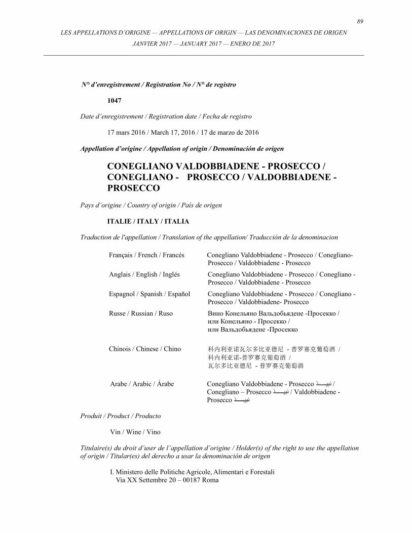
89
LES APPELLATIONS D’ORIGINE — APPELLATIONS OF ORIGIN — LAS DENOMINACIONES DE ORIGEN
JANVIER 2017 — JANUARY 2017 — ENERO DE 2017
N° d’enregistrement / Registration No / N° de registro
1047
Date d’enregistrement / Registration date / Fecha de registro
17 mars 2016 / March 17, 2016 / 17 de marzo de 2016 Appellation d’origine / Appellation of origin / Denominación de origen
CONEGLIANO VALDOBBIADENE - PROSECCO / CONEGLIANO - PROSECCO / VALDOBBIADENE - PROSECCO
Pays d’origine / Country of origin / País de origen
ITALIE / ITALY / ITALIA Traduction de l'appellation / Translation of the appellation/ Traducción de la denominacion
Français / French / Francés Conegliano Valdobbiadene - Prosecco / Conegliano-Prosecco / Valdobbiadene - Prosecco
Anglais / English / Inglés Conegliano Valdobbiadene - Prosecco / Conegliano - Prosecco / Valdobbiadene - Prosecco
Espagnol / Spanish / Español Conegliano Valdobbiadene - Prosecco / Conegliano - Prosecco / Valdobbiadene- Prosecco
Russe / Russian / Ruso Вино Конельянo Вальдобьядене -Просекко / или Конельянo - Просекко / или Вальдобьядене -Просекко
Chinois / Chinese / Chino
科内利亚诺瓦尔多比亚德尼 - 普罗赛克葡萄酒 / 科内利亚诺-普罗赛克葡萄酒 / 瓦尔多比亚德尼 - 普罗赛克葡萄酒
Arabe / Arabic / Árabe Conegliano Valdobbiadene - Prosecco نبي����������ذ / Conegliano – Prosecco نبي����������ذ / Valdobbiadene - Prosecco نبي����������ذ
Produit / Product / Producto
Vin / Wine / Vino Titulaire(s) du droit d’user de l’appellation d’origine / Holder(s) of the right to use the appellation of origin / Titular(es) del derecho a usar la denominación de origen
I. Ministero delle Politiche Agricole, Alimentari e Forestali Via XX Settembre 20 – 00187 Roma
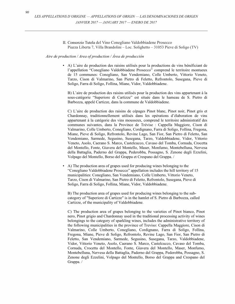
90 LES APPELLATIONS D’ORIGINE — APPELLATIONS OF ORIGIN — LAS DENOMINACIONES DE ORIGEN
JANVIER 2017 — JANUARY 2017 — ENERO DE 2017
II. Consorzio Tutela del Vino Conegliano Valdobbiadene Prosecco
Piazza Liberta 7, Villa Brandolini – Loc. Solighetto – 31053 Pieve di Soligo (TV) Aire de production / Area of production / Área de producción
▪ A) L’aire de production des raisins utilisés pour la productions de vins bénéficiant de
l’appellation “Conegliano Valdobbiadene Prosecco” comprend le territoire montueux de 15 communes: Conegliano, San Vendemiano, Colle Umberto, Vittorio Veneto, Tarzo, Cison di Valmarino, San Pietro di Feletto, Refrontolo, Susegana, Pieve di Soligo, Farra di Soligo, Follina, Miane, Vidor, Valdobbiadene.
B) L’aire de production des raisins utilisés pour la production des vins appartenant à la
sous-catégorie “Superiore di Cartizze” est située dans le hameau de S. Pietro di Barbozza, appelé Cartizze, dans la commune de Valdobbiadene.
C) L’aire de production des raisins de cépages Pinot blanc, Pinot noir, Pinot gris et
Chardonnay, traditionnellement utilisés dans les opérations d’élaboration de vins appartenant à la catégorie des vins mousseux, comprend le territoire administratif des communes suivantes, dans la Province de Trévise : Cappella Maggiore, Cison di Valmarino, Colle Umberto, Conegliano, Cordignano, Farra di Soligo, Follina, Fregona, Miane, Pieve di Soligo, Refrontolo, Revine Lago, San Fior, San Pietro di Feletto, San Vendemiano, Sarmede, Segusino, Susegana, Tarzo, Valdobbiadene, Vidor, Vittorio Veneto, Asolo, Caerano S. Marco, Castelcucco, Cavaso del Tomba, Cornuda, Crocetta del Montello, Fonte, Giavera del Montello, Maser, Monfumo, Montebelluna, Nervesa della Battaglia, Paderno del Grappa, Pederobba, Possagno, S. Zenone degli Ezzelini, Volpago del Montello, Borso del Grappa et Crespano del Grappa. /
▪ A) The production area of grapes used for producing wines belonging to the
“Conegliano Valdobbiadene Prosecco” appellation includes the hill territory of 15 municipalities: Conegliano, San Vendemiano, Colle Umberto, Vittorio Veneto, Tarzo, Cison di Valmarino, San Pietro di Feletto, Refrontolo, Susegana, Pieve di Soligo, Farra di Soligo, Follina, Miane, Vidor, Valdobbiadene.
B) The production area of grapes used for producing wines belonging to the sub-
category of "Superiore di Cartizze" is in the hamlet of S. Pietro di Barbozza, called Cartizze, of the municipality of Valdobbiadene.
C) The production area of grapes belonging to the varieties of Pinot bianco, Pinot
nero, Pinot grigio and Chardonnay used in the traditional processing activity of wines belongings to the category of sparkling wines, includes the administrative territory of the following municipalities in the province of Treviso: Cappella Maggiore, Cison di Valmarino, Colle Umberto, Conegliano, Cordignano, Farra di Soligo, Follina, Fregona, Miane, Pieve di Soligo, Refrontolo, Revine Lago, San Fior, San Pietro di Feletto, San Vendemiano, Sarmede, Segusino, Susegana, Tarzo, Valdobbiadene, Vidor, Vittorio Veneto, Asolo, Caerano S. Marco, Castelcucco, Cavaso del Tomba, Cornuda, Crocetta del Montello, Fonte, Giavera del Montello, Maser, Monfumo, Montebelluna, Nervesa della Battaglia, Paderno del Grappa, Pederobba, Possagno, S. Zenone degli Ezzelini, Volpago del Montello, Borso del Grappa and Crespano del Grappa. /
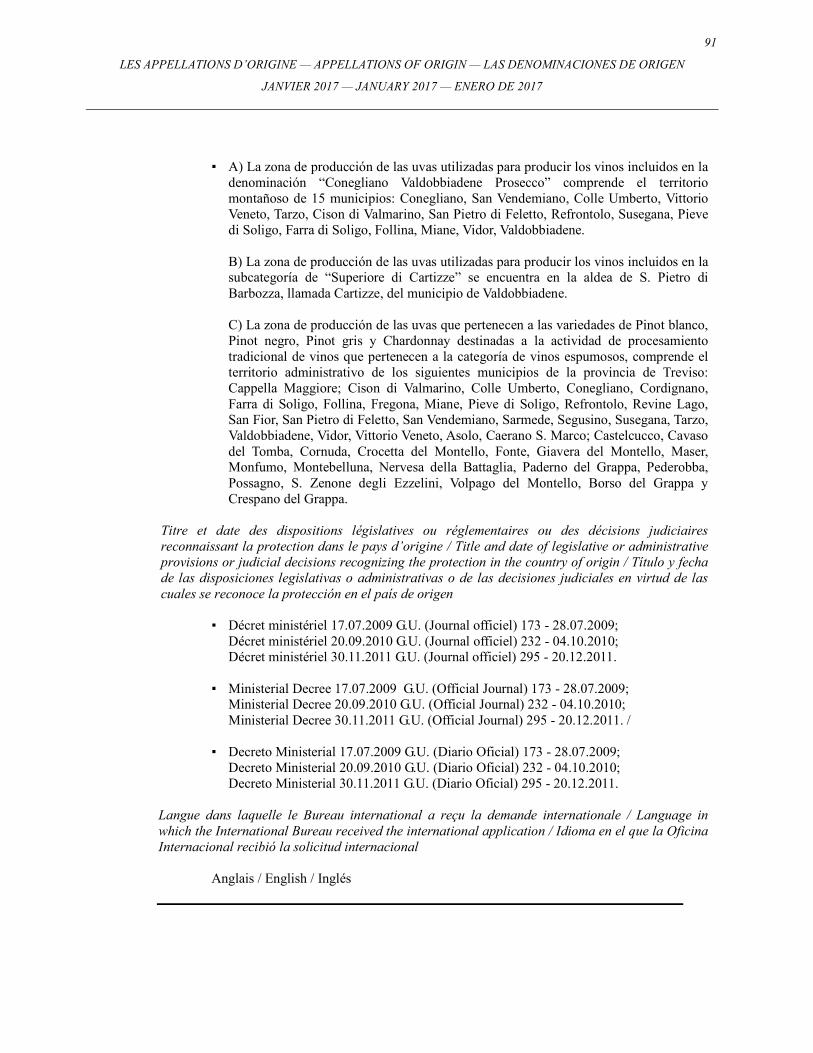
91
LES APPELLATIONS D’ORIGINE — APPELLATIONS OF ORIGIN — LAS DENOMINACIONES DE ORIGEN
JANVIER 2017 — JANUARY 2017 — ENERO DE 2017
▪ A) La zona de producción de las uvas utilizadas para producir los vinos incluidos en la denominación “Conegliano Valdobbiadene Prosecco” comprende el territorio montañoso de 15 municipios: Conegliano, San Vendemiano, Colle Umberto, Vittorio Veneto, Tarzo, Cison di Valmarino, San Pietro di Feletto, Refrontolo, Susegana, Pieve di Soligo, Farra di Soligo, Follina, Miane, Vidor, Valdobbiadene.
B) La zona de producción de las uvas utilizadas para producir los vinos incluidos en la
subcategoría de “Superiore di Cartizze” se encuentra en la aldea de S. Pietro di Barbozza, llamada Cartizze, del municipio de Valdobbiadene.
C) La zona de producción de las uvas que pertenecen a las variedades de Pinot blanco,
Pinot negro, Pinot gris y Chardonnay destinadas a la actividad de procesamiento tradicional de vinos que pertenecen a la categoría de vinos espumosos, comprende el territorio administrativo de los siguientes municipios de la provincia de Treviso: Cappella Maggiore; Cison di Valmarino, Colle Umberto, Conegliano, Cordignano, Farra di Soligo, Follina, Fregona, Miane, Pieve di Soligo, Refrontolo, Revine Lago, San Fior, San Pietro di Feletto, San Vendemiano, Sarmede, Segusino, Susegana, Tarzo, Valdobbiadene, Vidor, Vittorio Veneto, Asolo, Caerano S. Marco; Castelcucco, Cavaso del Tomba, Cornuda, Crocetta del Montello, Fonte, Giavera del Montello, Maser, Monfumo, Montebelluna, Nervesa della Battaglia, Paderno del Grappa, Pederobba, Possagno, S. Zenone degli Ezzelini, Volpago del Montello, Borso del Grappa y Crespano del Grappa.
Titre et date des dispositions législatives ou réglementaires ou des décisions judiciaires reconnaissant la protection dans le pays d’origine / Title and date of legislative or administrative provisions or judicial decisions recognizing the protection in the country of origin / Título y fecha de las disposiciones legislativas o administrativas o de las decisiones judiciales en virtud de las cuales se reconoce la protección en el país de origen
▪ Décret ministériel 17.07.2009 G.U. (Journal officiel) 173 - 28.07.2009; Décret ministériel 20.09.2010 G.U. (Journal officiel) 232 - 04.10.2010; Décret ministériel 30.11.2011 G.U. (Journal officiel) 295 - 20.12.2011.
▪ Ministerial Decree 17.07.2009 G.U. (Official Journal) 173 - 28.07.2009;
Ministerial Decree 20.09.2010 G.U. (Official Journal) 232 - 04.10.2010; Ministerial Decree 30.11.2011 G.U. (Official Journal) 295 - 20.12.2011. /
▪ Decreto Ministerial 17.07.2009 G.U. (Diario Oficial) 173 - 28.07.2009;
Decreto Ministerial 20.09.2010 G.U. (Diario Oficial) 232 - 04.10.2010; Decreto Ministerial 30.11.2011 G.U. (Diario Oficial) 295 - 20.12.2011.
Langue dans laquelle le Bureau international a reçu la demande internationale / Language in which the International Bureau received the international application / Idioma en el que la Oficina Internacional recibió la solicitud internacional
Anglais / English / Inglés
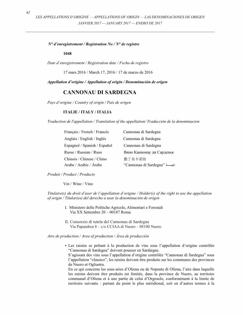
92 LES APPELLATIONS D’ORIGINE — APPELLATIONS OF ORIGIN — LAS DENOMINACIONES DE ORIGEN
JANVIER 2017 — JANUARY 2017 — ENERO DE 2017
N° d’enregistrement / Registration No / N° de registro
1048
Date d’enregistrement / Registration date / Fecha de registro
17 mars 2016 / March 17, 2016 / 17 de marzo de 2016 Appellation d’origine / Appellation of origin / Denominación de origen
CANNONAU DI SARDEGNA
Pays d’origine / Country of origin / País de origen
ITALIE / ITALY / ITALIA Traduction de l'appellation / Translation of the appellation/ Traducción de la denominacion
Français / French / Francés Cannonau di Sardegna
Anglais / English / Inglés Cannonau di Sardegna
Espagnol / Spanish / Español Cannonau di Sardegna
Russe / Russian / Ruso Вино Каннонау ди Сарденья
Chinois / Chinese / Chino 撒丁岛卡诺纽
Arabe / Arabic / Árabe “Cannonau di Sardegna” نبي����������ذ Produit / Product / Producto
Vin / Wine / Vino
Titulaire(s) du droit d’user de l’appellation d’origine / Holder(s) of the right to use the appellation of origin / Titular(es) del derecho a usar la denominación de origen
I. Ministero delle Politiche Agricole, Alimentari e Forestali Via XX Settembre 20 – 00187 Roma
II. Consorzio di tutela del Cannonau di Sardegna
Via Papandrea 8 – c/o CCIAA di Nuoro – 08100 Nuoro
Aire de production / Area of production / Área de producción ▪ Les raisins se prêtant à la production de vins sous l’appellation d’origine contrôlée
“Cannonau di Sardegna” doivent pousser en Sardaigne. S’agissant des vins sous l’appellation d’origine contrôlée “Cannonau di Sardegna” sous
l’appellation “classico”, les raisins doivent être produits sur les communes des provinces de Nuoro et Ogliastra.
En ce qui concerne les sous-aires d’Oliena ou de Nepente di Oliena, l’aire dans laquelle les raisins doivent être produits est limitée, dans la province de Nuoro, au territoire communal d’Oliena et à une partie de celui d’Orgosolo, conformément à la limite de territoire suivante : partant du point le plus méridional, soit en d’autres termes à la
93
LES APPELLATIONS D’ORIGINE — APPELLATIONS OF ORIGIN — LAS DENOMINACIONES DE ORIGEN
JANVIER 2017 — JANUARY 2017 — ENERO DE 2017
jonction des limites communales d’Oliena, d’Orgoloso et de Dorgali aux sources d’Ozzastru, la limite suit celle de la comune d’Oliena vers l’ouest jusqu’à Settile Osporrai, où, à une altitude de 953 m au-dessus du niveau de la mer, elle croise un affluent de la rivière Tortu, descend le long de cet affluent avant de suivre la rivière Torku jusqu’à l’endroit où elle se jette dans la rivière Sorasi. La limite se prolonge vers le sud, le long du cours d’eau du Sorasi puis à une altitude de 475 m, remonte sur la gauche de l’affluent, jusqu’à ce qu’elle atteigne, à une altitude de 474 m la route qui longe le cours d’eau. De cette altitude de 474 m, en allant vers l’ouest, cette ligne de démarcation suit la route qui longe le cours du Sorasi jusqu’à ce qu’elle croise la route entre Orgoloso et Oliena, en poursuivant le long de cette route en direction d’Oliena et, une fois passé le kilomètre 17, en suivant le fossé qui s’élève à une hauteur de 629 mètres, atteint l’altitude de 550 m, le suit vers le nord sur 500 m environ puis tourne vers l’est, jusqu’à atteindre la route d’Oliena au niveau du pont de S.Archimissa. La limite suit cette route en direction d’Oliena, jusqu’à ce qu’elle rencontre la limite communale qu’elle suit vers une direction nord-ouest jusqu’à Virdarosa; elle se poursuit vers l’ouest, en suivant cette route, pour atteindre Rovine di Santa Maria, à partir d’où elle prend l’itinéraire de Rovine di San Paolo en traversant Funtana Mala, prend la direction du sud sur 400 m avant de revenir en arrière dans une direction ouest, traversant le village de Teulaspru; dans cette direction elle atteint la route menant à Baddu et Carru puis prend une ligne droite vers l’ouest avant d’atteindre la route de Nuoro à 13 km. Elle continue le long de cette route vers le nord et, au kilomètre 7.550 environ, croise la limite communale d’Oliena, qu’elle suit, d’abord dans une direction nord, puis est, et enfin sud jusqu’à ce qu’elle atteigne le point où les trois limites communales d’Oliena, d’Ogosolo et de Dorgali s’entrecoupent.
En ce qui concerne la sous-aire «Capo Ferrato», l’aire de production est réservée à des raisins vendangés sur les communes de Castiadas, Muravera, San Vito, Villaputzu et Villasimius dans la province de Cagliari.
En ce qui concerne les sous-aires de «Jerzu», l’aire de production se limite aux raisins vendangés sur les communes de Jerzu et Cardedu dans la province d’Ogliastra. /
▪ Grapes suitable for producing the Controlled Designation of Origin "Cannonau di
Sardegna" wines must be grown in Sardinia. For "Cannonau di Sardegna" Controlled Designation of Origin wines with the
"classico", designation, the grapes must be produced within the municipalities of the provinces of Nuoro and Ogliastra.
For the Oliena or Nepente di Oliena sub-zones, the zone where grapes can be produced is limited, in the province of Nuoro, to the municipal territory of Oliena and partially Orgosolo, according to the following demarcation line: starting from the most southerly point, in other words where the municipal boundaries of Oliena, Orgosolo and Dorgali meet at the Ozzastru Springs, the demarcation line follows the Oliena municipal boundary westwards up to Settile Osporrai where at a height of 953 m above sea-level, it meets a tributary of the Tortu brook, descends along this tributary before following the Tortu brook to where it flows into the Sorasi brook. It continues, southwards, along Sorasi stream and then at a height of 475 m, goes up the left tributary until, at a height of 474 m, it reaches the road running alongside the watercourse. From this height of 474 m, heading west, the demarcation line follows the road running alongside Sorasi stream until it meets the road between Orgosolo and Oliena, continuing along this road in the direction of Oliena and, once the 17 km mark has been passed, following the ditch which rises to a height of 629 metres, reaches the height of 550 m, follows it north for around 500 m and then curls east, until it meets the road for Oliena at S. Archimissa bridge. The line follows this road towards Oliena
94 LES APPELLATIONS D’ORIGINE — APPELLATIONS OF ORIGIN — LAS DENOMINACIONES DE ORIGEN
JANVIER 2017 — JANUARY 2017 — ENERO DE 2017
until it meets the municipal boundary which it follows in a north - westerly direction up to Virdarosa; it continues west, following this road, and reaches Rovine di Santa Maria, from where it takes the route to Rovine di San Paolo and passing through Funtana Mala, heads south for 400 m before turning back in a westward direction crossing the village of Teulaspru; in this way it reaches the road leading to Baddu and Carru and then takes a straight line west before reaching the road for Nuoro at 13 km. It continues along this road northwards and at approximately 7.550 km crosses the Oliena municipal boundary, which it follows, first in a northern direction then heading east and then southwards until it reaches the point where the three municipal boundaries of Oliena, Orgosolo and Dorgali intersect.
For the "Capo Ferrato" sub-zone, the production area is reserved for grapes picked in the municipalities of Castiadas, Muravera, San Vito, Villaputzu and Villasimius in the province of Cagliari.
For the "Jerzu" sub-zones, the area of production is limited to grapes harvested in the municipalities of J erzu and Cardedu in the province of Ogliastra. /
▪ Las uvas aptas para la producción de los vinos con la denominación de origen
controlada “Cannonau di Sardegna” deben ser cultivadas en Cerdeña. Las uvas destinadas a la producción de vinos con la DOC “Cannonau di Sardegna” de
categoría “classico”, deben cultivarse entre los municipios de las provincias de Nuoro y Ogliastra.
En las subzonas de Oliena o Nepente di Oliena, la zona de la provincia de Nuoro en que deben producirse las uvas, está confinada al territorio municipal de Oliena y una parte de Orgosolo, tal como lo indica la siguiente línea de demarcación: el punto de partida de referencia es la zona situada en el extremo sur, es decir, el lugar de convergencia de las lindes de los municipios de Oliena, Orgosolo y Dorgali cerca al arroyo de Ozzastru, desde allí sigue hacia el oeste la linde municipal de Oliena hasta Settile Osporrai donde, a 953 m de altura sobre el nivel del mar, se encuentra con el tributario del riachuelo Tortu, que sigue río abajo en el sentido de este último, para desembocar en el riachuelo Sorasi. De allí continúa al sur por el arroyo Sorasi y a 475 m río arriba por el lado izquierdo del tributario hasta llegar a la carretera, a 474 m de altura, a lo largo del cauce.
A la misma altitud, la línea de demarcación continúa dirección oeste la carretera por el arroyo de Sorasi hasta llegar a la carretera situada entre Orgosolo y Oliena. En dirección de Oliena, después de pasar la baliza del kilómetro 17, sigue por una acequia de 629 m de altura, luego otra de 550 m, prosigue hacia el norte por alrededor de 500 m y luego bifurca hacia el este hasta encontrarse con la carretera que conduce a Oliena en el puente S. Archimissa. La línea bordea esta carretera hacia Oliena hasta la linde municipal y sigue sin desviarse en dirección noroeste hasta Virdarosa; de allí prosigue hacia el oeste, siguiendo por esta misma carretera, a Rovine di San Paolo y pasa a través de Funtana Mala, recorre unos 400 m al sur antes de dar media vuelta al oeste al cruzar el pueblo de Teulaspru; por este camino llega a la carretera que conduce a Baddu y Carru, sigue derecho hacia el oeste antes de llegar a Nuoro a 13 km de distancia. Sin desviarse, continua hacia el norte y a aproximadamente 7.550 km cruza la linde municipal de Oliena, por la que continuará en dirección norte, luego al este y finalmente al sur hasta llegar al punto de intersección de las tres lindes municipales de Oliena, Orgosolo y Dorgali.
Respecto de la subzonas de “Capo Ferrato”, el área de producción de las uvas seleccionadas se limita a los municipios de Castiadas, Muravera, San Vito, Villaputzu y Villasimius en la provincia de Cagliari.
En el caso de las subzonass de “Jerzu”, el área de producción está integrada por los municipios de Jerzu y Cardeu en la provincia de Ogliastra.
95
LES APPELLATIONS D’ORIGINE — APPELLATIONS OF ORIGIN — LAS DENOMINACIONES DE ORIGEN
JANVIER 2017 — JANUARY 2017 — ENERO DE 2017
Titre et date des dispositions législatives ou réglementaires ou des décisions judiciaires reconnaissant la protection dans le pays d’origine / Title and date of legislative or administrative provisions or judicial decisions recognizing the protection in the country of origin / Título y fecha de las disposiciones legislativas o administrativas o de las decisiones judiciales en virtud de las cuales se reconoce la protección en el país de origen
▪ Décret du President de la Republique Italienne 21.07.1972, G.U. (Journal Officiel) 248
-21.09.1972; Décret Ministeriel 29.06.1982, G.U. (Journal Officiel) 226 - 18.08.1982; Décret Ministeriel 05.11.1992, G.U. (Journal Officiel) 272 - 18.11.1992; Décret Ministeriel 04.11.2011, G.U. (Journal Officiel) 272 - 22.11.2011; Décret Ministeriel 30.11.2011, G.U. (Journal Officiel) 295 - 20.12.2011; Décret Ministeriel 07.03.2014; /
▪ Decree of the President of the Italian Republic 21.07.1972, G.U. (Official Journal) 248
-21.09.1972; Ministerial Decree 29.06.1982, G.U. (Official Journal) 226 - 18.08.1982; Ministerial Decree 05.11.1992, G.U. (Official Journal) 272 - 18.11.1992; Ministerial Decree 04.11.2011, G.U. (Official Journal) 272 - 22.11.2011; Ministerial Decree 30.11.2011, G.U. (Official Journal) 295 - 20.12.2011; Ministerial Decree 07.03.2014. /
▪ Decreto del Presidente de la República de Italia 21.07.1972, G.U. (Diario Oficial) 248
-21.09.1972; Decreto Ministerial 29.06.1982, G.U. (Diario Oficial) 226 - 18.08.1982; Decreto Ministerial 05.11.1992, G.U. (Diario Oficial) 272 - 18.11.1992; Decreto Ministerial 04.11.2011, G.U. (Diario Oficial) 272 - 22.11.2011; Decreto Ministerial 30.11.2011, G.U. (Diario Oficial) 295 - 20.12.2011; Decreto Ministerial 07.03.2014;
Langue dans laquelle le Bureau international a reçu la demande internationale / Language in which the International Bureau received the international application / Idioma en el que la Oficina Internacional recibió la solicitud internacional
Anglais / English / Inglés
96 LES APPELLATIONS D’ORIGINE — APPELLATIONS OF ORIGIN — LAS DENOMINACIONES DE ORIGEN
JANVIER 2017 — JANUARY 2017 — ENERO DE 2017
N° d’enregistrement / Registration No / N° de registro
1049
Date d’enregistrement / Registration date / Fecha de registro
17 mars 2016 / March 17, 2016 / 17 de marzo de 2016 Appellation d’origine / Appellation of origin / Denominación de origen
BASILICO GENOVESE
Pays d’origine / Country of origin / País de origen
ITALIE / ITALY / ITALIA Traduction de l'appellation / Translation of the appellation/ Traducción de la denominacion
Français / French / Francés Basilic génois
Anglais / English / Inglés Basil from Genoa
Espagnol / Spanish / Español Albahaca genovesa
Russe / Russian / Ruso Базилик из Генуи "Базилико Дженовезе"
Chinois / Chinese / Chino 热内亚罗勒
Arabe / Arabic / Árabe “Basilico Genovese” ريحان Produit / Product / Producto
Basilic frais / Fresh basil / Albahaca fresca
Titulaire(s) du droit d’user de l’appellation d’origine / Holder(s) of the right to use the appellation of origin / Titular(es) del derecho a usar la denominación de origen
I. Ministero delle Politiche Agricole, Alimentari e Forestali Via XX Settembre 20 – 00187 Roma
II. Consorzio di Tutela del Basilico Genovese DOP
Villa Doria Podestà – Via Pra 63 – 16157 Genova
Aire de production / Area of production / Área de producción ▪ L’aire de production de la AOP "Basilico Genovese" se limite uniquement au versant
Tyrrhénien du territoire administratif de la région de Ligurie, sa délimitation se confondant avec la ligne de partage des eaux. /
97
LES APPELLATIONS D’ORIGINE — APPELLATIONS OF ORIGIN — LAS DENOMINACIONES DE ORIGEN
JANVIER 2017 — JANUARY 2017 — ENERO DE 2017
▪ The production area of "Basilico Genovese" PDO is limited only to the Tyrrhenian side of the Liguria Region administrative area, with delimitation which can be identified in the watershed. /
▪ El área de producción de “Basilico Genovese” se limita únicamente a la zona del
Tirreno perteneciente al área administrativa de la región de la Liguria, delimitada por una línea divisoria de las aguas del litoral.
Titre et date des dispositions législatives ou réglementaires ou des décisions judiciaires reconnaissant la protection dans le pays d’origine / Title and date of legislative or administrative provisions or judicial decisions recognizing the protection in the country of origin / Título y fecha de las disposiciones legislativas o administrativas o de las decisiones judiciales en virtud de las cuales se reconoce la protección en el país de origen
▪ Règlement (CE) n° 1623/2005 de la Commission du 4 octobre 2005; Réglement (CE) n° 611/2010 de la Commission du 12 juillet 2010. ▪ Regulation (EC) No. 1623/2005 of the Commission of October 04, 2005; Regulation (EC) No. 611/2010 of the Commission of July 12, 2010. / ▪ Reglamento (CE) Nº 1623/2005 de la Comisión, de 4 de octubre de 2005 Reglamento (CE) Nº 611/2010 de la Comisión, de 12 de julio de 2010.
Langue dans laquelle le Bureau international a reçu la demande internationale / Language in which the International Bureau received the international application / Idioma en el que la Oficina Internacional recibió la solicitud internacional
Anglais / English / Inglés
98 LES APPELLATIONS D’ORIGINE — APPELLATIONS OF ORIGIN — LAS DENOMINACIONES DE ORIGEN
JANVIER 2017 — JANUARY 2017 — ENERO DE 2017
N° d’enregistrement / Registration No / N° de registro
1050
Date d’enregistrement / Registration date / Fecha de registro
17 mars 2016 / March 17, 2016 / 17 de marzo de 2016 Appellation d’origine / Appellation of origin / Denominación de origen
COLLI ORIENTALI DEL FRIULI PICOLIT
Pays d’origine / Country of origin / País de origen
ITALIE / ITALY / ITALIA Traduction de l'appellation / Translation of the appellation/ Traducción de la denominacion
Français / French / Francés Colli Orientali del Friuli Picolit
Anglais / English / Inglés Colli Orientali del Friuli Picolit
Espagnol / Spanish / Español Colli Orientali del Friuli Picolit
Russe / Russian / Ruso Вино Колли Ориентали дель Фриули
Chinois / Chinese / Chino 弗留利东山
Arabe / Arabic / Árabe “Colli Orientali del Friuli Picolit” نبي����������ذ Produit / Product / Producto
Vin / Wine / Vino
Titulaire(s) du droit d’user de l’appellation d’origine / Holder(s) of the right to use the appellation of origin / Titular(es) del derecho a usar la denominación de origen
I. Ministero delle Politiche Agricole, Alimentari e Forestali Via XX Settembre 20 – 00187 Roma
II. Consorzio tutela vini Friuli Colli Orientali e Ramandolo
Via G.B. Candotti 3 – Cividale del Friuli (UD) Aire de production / Area of production / Área de producción
▪ “Colli Orientali del Friuli Picolit”
Les raisins mentionnés à l’article 2 doivent être produits dans l’aire de production décrite ci-dessous: à partir du village de Madonna, à l’ouest de Tarcento, la ligne de délimitation suit la route reliant ce village à la gare de Tarcento, longe la voie ferrée en direction du sud jusqu’à rejoindre la route provinciale reliant Tricesimo à Nimis, puis suit cette route, traverse Qualso et Qualso Nuovo jusqu’au pont de Nimis sul Torre. Elle continue alors en direction du sud le long de ce torrent jusqu’au pont de Savorgnano, puis en direction de l’est le long de la route menant à Savorgnano jusqu’à rejoindre et suivre la route menant à Bognini et C. Maurino; à partir de là, elle continue en suivant la
99
LES APPELLATIONS D’ORIGINE — APPELLATIONS OF ORIGIN — LAS DENOMINACIONES DE ORIGEN
JANVIER 2017 — JANUARY 2017 — ENERO DE 2017
ligne électrique haute tension jusqu’au transformateur de Rubignacco (entre l’orphelinat et C. Corgnolo). A partir du transformateur, la ligne suit la route menant à Casali Gallo, aux abattoirs municipaux et à Borgo Viola (au sud de Cividale) puis tourne vers l’est en direction de Borgo Corfu’ avant de descendre le long de la route nationale SS 356, jusqu’à rejoindre le carrefour de Spessa – Ipplis en passant par Gagliano; à partir de ce point, elle tourne vers l’ouest le long de la route pavée délimitant le versant nord de la zone montueuse jusqu’à rejoindre le carrefour d’Azzano avant de repartir vers Leproso et de continuer en direction du pont traversant la rivière Natisone, en direction d’Orsaria, puis de suivre la route provinciale jusqu’à Vicinale (y compris la Casa delle zitelle) pour poursuivre le long de ladite route provinciale jusqu’à son embranchement avec la route nationale 56.
La ligne de délimitation suit la route nationale 56 en direction du sud-est jusqu’au carrefour menant à Manzano et à la route traversant Manzano, rejoignant la chaussée revêtue entre Case et Dolegnano à proximité de de C. Romano. La ligne continue en direction de l’est le long de cette route revêtue avant de rejoindre la frontière des provinces d’Udine et de Gorizia, après avoir traversé Dolegnano, Piazzale Quattro Venti et S. Andrat. Longeant ensuite la frontière nationale en direction du nord jusqu’au canal de Goritnich, elle suit ledit canal jusqu’au chemin de ferme; puis elle passe au-dessus des villages de Fragielis et Stregna et, après avoir atteint San Pietro di Chiazzacco, continue en direction de C. Chiaro et Cialla jusqu’à rejoindre Mozzomonte sur la route de Castelmonte, avant de continuer le long des limites de la ville de Torreano jusqu’au mont Mladesena. A partir de ce point, la limite suit une ligne droite reliant le mont Mladesena (711 mètres), le mont Forcis (559 mètres), le mont Dolina (441 mètres), le mont Quarde (429 mètres), le mont Poiana (369 mètres), la colline de San Giorgio (379 mètres), le mont Zuc (470 mètres), le mont Pocivalo (791 mètres), Borgo Gaspar (368 mètres) et le château de Prampero (213 mètres). La ligne de délimitation continue en direction du sud le long de la route traversant Borgo Foranesi puis, une fois arrivée à proximité de Borgo Polla, dévie vers l’ouest pour rejoindre la route nationale 356, qu’elle suit jusqu’au village de Madonna, à l’ouest de Tarcento.
“Colli Orientali del Friuli Picolit” - sous-aire de “Cialla”
Les raisins destinés à la production de vin bénéficiant de l’appellation d’origine contrôlée et garantie “Colli Orientali del Friuli Picolit” - sous-aire de “Cialla”, doivent être produits dans les aires précitées; à partir des limites de la commune de Prepotto, l’aire en question est délimitée au nord par la route provinciale reliant Cividale à Castelmonte, incluant les villages de Mezzomonte et Casali Suoc. A 490 mètres d’altitude, la ligne fait un demi-tour pour atteindre 496 mètres, traverse la route reliant S. Pietro di Chiazzacco à Castelmonte jusqu’à une altitude de 612 mètres ; à ce point, la ligne dévie vers l’est pour redescendre à 294 mètres, passant au-dessus de Casalli Magnana et Case sotto S. Pietro; suivant un tracé quasi constant à 200 mètres, la ligne rejoint à nouveau les limites de la commune, entre les routes communales reliant Casali Barbianis à Cialla et Casali Barbianis à Cladrecis; à partir de ce point, la ligne de délimitation se confond avec les limites de la commune de Prepotto. /
▪ “Colli Orientali del Friuli Picolit” Grapes indicated at the article 2 have to be produced in the below reported area: starting
from the village of Madonna, west of Tarcento, the demarcation line follows the road which from this village leads to the railway station of Tarcento and follows the railway line southwards until it meets the Tricesimo – Nimis provincial road, following this road, through Qualso and Qualso Nuovo, until the bridge of Nimis sul Torre. It then heads south along this torrent up to Savorgnano bridge, heading eastwards along the
100 LES APPELLATIONS D’ORIGINE — APPELLATIONS OF ORIGIN — LAS DENOMINACIONES DE ORIGEN
JANVIER 2017 — JANUARY 2017 — ENERO DE 2017
road leading to Savorgnano until it meets and follows the road for M. Bognini and C. Maurino; from here, it continues along the high-voltage electricity line until it reaches the substation at Rubignacco (between the orphanage and C. Corgnolo). From the substation, the line follows the road towards Casali Gallo, the Municipal Slaughterhouse and Borgo Viola (to the south of Cividale) and then turns eastwards, for Borgo Corfu', before going downhill along the state road SS 356, until it reaches the Spessa – Ipplis junction, passing through Gagliano; from this point it runs westwards along the paved road demarcating the northern section of the hilly area, until it reaches the Azzano junction before heading towards Leproso and continuing towards the bridge over the river Natisone towards Orsaria and then along the provincial road up to Vicinale (Casa delle zitelle included) then continuing along this provincial road until it reaches the link with the state road SS 56. The demarcation line follows the state road SS 56, heading south-east, up to the junction for Manzano and the road which runs through Manzano reaching the Case – Dolegnano paved road near C. Romano. It continues eastwards along the aforementioned surfaced road before reaching the Udine – Gorizia provincial boundary after crossing Dolegnano, Piazzale Quattro Venti and S. Andrat. It follows the state border northwards up to the Goritnich brook. It runs along this brook up to the farm road; it then runs above the villages of Fragielis e Stregna and once it has reached San Pietro di Chiazzacco, continues towards C. Chiaro and Cialla until reaching Mezzomonte on the road for Castelmonte, before continuing along the Cividale municipal border, northwards along the Torreano boundary up to Mount Mladesena. From here in a straight line linking Mount Mladesena (711 m), Mount Forcis (559 m), Mount Dolina (441 m), Mount Quarde (429 m), Mount Poiana (369 m) San Giorgio hill (379 m), Mount Zuc (470 m), Mount Pocivalo (791 m), Borgo Gaspar (368 m) and the castle of Prampero (213 m). The demarcation line continues southwards along the road crossing Borgo Foranesi and once arriving near Borgo Polla, veers westwards, reaching SS 356 state road which it follows up to the village of Madonna, to the west of Tarcento. “Colli Orientali del Friuli Picolit” – “Cialla” The grapes used to produce the Controlled and Guaranteed Designation of Origin “Colli Orientali del Friuli Picolit” – “Cialla” sub-area wine must be produced in the abovementioned area: starting from the boundary of the municipality of Prepotto, the area in question is demarcated northwards by the Cividale – Castelmonte provincial road, which includes the villages of Mezzomonte and Casali Suoc. At a height of 490 m, the line curves back, reaching a height of 496 m, crossing the S. Pietro di Chiazzacco – Castelmonte road up to a height of 612 m; at this point the line veers east, until it reaches 294 m, passing above Casali Magnana and Case sotto S. Pietro; proceeding almost constantly at a height of 200 m, the line joins the municipal boundary again, between the Casali Barbianis - Cialla and Casali Barbianis – Cladrecis municipal roads; from here on the demarcation line is the same as that of the municipality of Prepotto. /
▪ “Colli Orientali del Friuli Picolit”
Las uvas mencionadas en el artículo 2 deben ser producidas en la zona que figura a continuación: partiendo de la localidad de Madonna, al oeste de Tarcento, la línea de demarcación sigue la carretera que lleva del pueblo a la estación de tren de Tarcento y sigue la vía del tren hacia el sur, hasta el cruce con la carretera provincial Tricesimo – Nimis, continúa por esta carretera, atravesando Qualso y Qualso Nuovo, hasta el puente de Nimis sul Torre. A continuación, sigue el torrente hacia el sur, hasta el puente de Savorgnano, gira al este por la carretera que va a Savorgnano hasta cruzarla y seguir la carretera a M. Bognini y C. Maurino; de aquí, sigue las líneas eléctricas de alta tensión hasta que llega a la subestación eléctrica de Rubignacco (entre el orfelinato y
101
LES APPELLATIONS D’ORIGINE — APPELLATIONS OF ORIGIN — LAS DENOMINACIONES DE ORIGEN
JANVIER 2017 — JANUARY 2017 — ENERO DE 2017
C. Corgnolo). Desde la subestación eléctrica la línea sigue la carretera de Casali Gallo, el matadero municipal, Borgo Viola (al sur de Cividale) y luego gira hacia el este, por Borgo Corfu, para bajar hacia la carretera nacional Nº 356, hasta que llega al cruce Spessa - lpplis, pasando por Gagliano; de aquí va hacia el oeste a lo largo de la carretera asfaltada que delimita la cara norte de las colinas, hasta llegar al cruce de Azzano para dirigirse hacia Leproso y continuar por el puente sobre el río Natisone hacia Orsaria y continuar después a lo largo de la carretera provincial hasta llegar a Vicinale (incluida Casa delle zitelle) y proseguir a lo largo de la carretera provincial hasta llegar al enlace con la carretera nacional Nº 56. La línea de demarcación sigue la nacional Nº 56, en dirección sudeste, hasta el cruce para Manzano y la carretera que atraviesa la localidad y desemboca en la carretera asfaltada Case - Dolegnano a proximidad de C. Romano. Continúa hacia el este a lo largo de la carretera asfaltada mencionada hasta llegar al linde provincial Udine – Gorizia tras cruzar Dolegnano, piazzale Quattro Venti y S. Andrat. Sigue el linde estatal hacia el norte hasta el riachuelo Goritnich. Del riachuelo sube hasta el camino de tierra y de ahí pasa sobre los pueblos de Fragielis y Stregna y, cuando llega a San Pietro di Chiazzacco, sigue hacia C. Chiaro y Cialla, hasta llegar a Mezzomonte por la carretera de Castelmonte, antes de bordear el linde municipal de Cividale y seguir hacia el norte a lo largo del linde de Torreano hasta la altura del monte Mladesena. Da aquí, en línea recta une el monte Mladesena (711 m), el monte Forcis (559 m), el monte Dolina (441 m), el monte Quarde (429 m), el monte Poiana (369 m), la colina de San Giorgio (379 m), el monte Zuc (470 m), el monte Pocivalo (791 m), Borgo Gaspar (368 m) y el castillo de Prampero (213 m). La línea de demarcación continúa hacia el sur por la carretera que cruza Borgo Foranesi y, al llegar a proximidad de Borgo Polla, se desvía hacia el oeste para llegar a la carretera nacional Nº. 356, que sigue hasta llegar al pueblo de Madonna, al oeste de Tarcento. “Colli Orientali del Friuli Picolit” - Subzona de “Cialla” Las uvas destinadas a la producción de los vinos de la Denominación de Origen Controlada y Garantizada “Colli Orientali del Friuli Picolit” - Subzona de “Cialla” deben ser producidas en la zona que figura a continuación: partiendo del linde del municipio de Prepotto, al norte, la zona en cuestión está delimitada por la carretera provincial Cividale - Castelmonte , abarcando los pueblos de Mezzomonte y Casali Suoc; a 490 m la línea regresa, alcanza los 496 m, cruza la carretera S. Pietro di Chiazzacco - Castelmonte hasta un altura de 612 m, en este punto la línea se desvía hacia el este, hasta la línea de los 294 m, pasa sobre Casali Magnana y Case sotto S. Pietro; siguiendo casi constantemente la línea de los 200m, llega una vez más al linde municipal, entre las carreteras comarcales Casali Barbianis – Cialla y Casali Barbianis – Cladrecis; desde aquí, la línea de demarcación coincide con el linde del municipio de Prepotto.
102 LES APPELLATIONS D’ORIGINE — APPELLATIONS OF ORIGIN — LAS DENOMINACIONES DE ORIGEN
JANVIER 2017 — JANUARY 2017 — ENERO DE 2017
Titre et date des dispositions législatives ou réglementaires ou des décisions judiciaires reconnaissant la protection dans le pays d’origine / Title and date of legislative or administrative provisions or judicial decisions recognizing the protection in the country of origin / Título y fecha de las disposiciones legislativas o administrativas o de las decisiones judiciales en virtud de las cuales se reconoce la protección en el país de origen
▪ Décret du Président de la République italienne 20.07.1970 G.U. (Journal Officiel) 247 - 30.09.1970;
Décret ministériel 30.03.2006 G.U. (Journal Officiel) 83 - 08.04.2006; Décret ministériel 26.05.2010 G.U. Journal Officiel) 144 - 23.06.2010; Décret ministériel 30.11.2011 G.U. (Journal Officiel) 295 - 20.12.2011; Décret ministériel 07.03.2014. / ▪ Decree of the President of the Italian Republic 20.07.1970 G.U. (Official Journal) 247 -
30.09.1970; Ministerial Decree 30.03.2006 G.U. (Official Journal) 83 - 08.04.2006; Ministerial Decree 26.05.2010 G.U. (Official Journal) 144 - 23.06.2010; Ministerial Decree 30.11.2011 G.U. (Official Journal) 295 - 20.12.2011; Ministerial Decree 07.03.2014. / ▪ Decreto del Presidente de la República Italiana 20.07.1970 G.U. (Diario Oficial) 247 -
30.09.1970; Decreto Ministerial 30.03.2006 G.U. (Diario Oficial) 83 - 08.04.2006; Decreto Ministerial 26.05.2010 G.U. (Diario Oficial) 144 - 23.06.2010; Decreto Ministerial 30.11.2011 G.U. (Diario Oficial) 295 - 20.12.2011; Decreto Ministerial 07.03.2014.
Langue dans laquelle le Bureau international a reçu la demande internationale / Language in which the International Bureau received the international application / Idioma en el que la Oficina Internacional recibió la solicitud internacional
Anglais / English / Inglés
103
LES APPELLATIONS D’ORIGINE — APPELLATIONS OF ORIGIN — LAS DENOMINACIONES DE ORIGEN
JANVIER 2017 — JANUARY 2017 — ENERO DE 2017
N° d’enregistrement / Registration No / N° de registro
1051
Date d’enregistrement / Registration date / Fecha de registro
17 mars 2016 / March 17, 2016 / 17 de marzo de 2016 Appellation d’origine / Appellation of origin / Denominación de origen
ORVIETO
Pays d’origine / Country of origin / País de origen
ITALIE / ITALY / ITALIA Traduction de l'appellation / Translation of the appellation/ Traducción de la denominacion
Français / French / Francés Orvieto
Anglais / English / Inglés Orvieto
Espagnol / Spanish / Español Orvieto
Russe / Russian / Ruso Вино Орвието
Chinois / Chinese / Chino 奥维多
Arabe / Arabic / Árabe “Orvieto” نبي����������ذ Produit / Product / Producto
Vin / Wine / Vino
Titulaire(s) du droit d’user de l’appellation d’origine / Holder(s) of the right to use the appellation of origin / Titular(es) del derecho a usar la denominación de origen
I. Ministero delle Politiche Agricole, Alimentari e Forestali Via XX Settembre 20 – 00187 Roma
II. Consorzio tutela dei Vini DOC di Orvieto
Corso Cavour 36 – 05018 Orvieto
Aire de production / Area of production / Área de producción ▪ a) Les raisins destinés à la production de vins "Orvieto" doivent être produits dans
l’aire comprenant, dans leur intégralité ou partiellement, les communes suivantes: Orvieto, Allerona, Alviano, Baschi, Castel Giorgio, Castel Viscardo, Ficulle, Guardea, Montecchio, Fabro, Montegabbione, Monteleone d’Orvieto, Porano dans la Province de Terni, ainsi que les communes de Castiglione in Teverina, Civitella D’Agliano, Graffignano, Lubriano, Bagnoregio dans la Province de Viterbe.
104 LES APPELLATIONS D’ORIGINE — APPELLATIONS OF ORIGIN — LAS DENOMINACIONES DE ORIGEN
JANVIER 2017 — JANUARY 2017 — ENERO DE 2017
Cette aire est délimitée comme suit: sur la route menant de Castelviscardo à Monte
Rubiaglio, juste avant ce village et à proximité de la station thermale, la limite suit la nouvelle route en direction de l’ouest, passant au-dessous du village jusqu’au carrefour menant à l’exploitation agricole de Stabbione; puis elle suit cette route jusqu’au canal de Pisciatello, qui poursuit sa course en direction du nord jusqu’à rejoindre le torrent de Paglia à une altitude de presque 164 mètres. A partir de ce point, la limite suit une ligne droite pour rejoindre l’exploitation agricole de Molino, à partir de laquelle elle repart en direction du nord-est en suivant la route menant à la ville de Stazione jusqu’à rejoindre le canal de Ripuglie.
La limite court alors le long de ce canal jusqu’à rejoindre l’exploitation agricole de Pianociano, suivant le chemin menant à Pratale (360 mètres d’altitude) puis, continuant sa route, rejoint la route provinciale menant à Allerona, emprunte cette route jusqu’à la ville, puis continue en direction du nord-est le long de la route qui traverse l’exploitation agricole de Fontalone, continue sur cette route jusqu’à rejoindre le canal de Rivasenne (280 mètres d’altitude), traverse ledit canal puis, après avoir atteint le hameau de Peccio, rejoint le canal de Rivarcale; la limite se dirige alors en direction du sud, longeant ledit canal, puis à 240 mètres d’altitude, suit le chemin à l’est menant à l’exploitation agricole de Poggio Lupo, qu’elle rejoint puis dévie en direction du nord-est, suit le chemin traversant les exploitations agricoles de Mostarda (335 mètres), d’Alvenella (275 mètres), continue jusqu’à atteindre 227 mètres d’altitude et, au pont traversant le canal de Rimucchie, part en ligne droite en direction de l’est jusqu’à atteindre 222 mètres, à proximité d’un cours d’eau que la limite suit jusqu’au point où ledit cours d’eau se jette dans le torrent de Ritorto à une altitude proche de 216 mètres.
La limite remonte alors le torrent de Ritorto puis, une fois dépassé Taie, emprunte la route en direction de l’est, atteignant une altitude de 242 mètres, emprunte le chemin qui, en direction du nord, passe par S. C. Marco (324 mètres d’altitude), continue vers le nord le long de ce chemin atteignant des points d’altitude de 348 mètres (Olivello), 359 mètres, 382 mètres, 293 mètres (Castel Rosso) et 387 mètres, puis rejoint la route qui conduit à Fabro. Elle continue le long de cette route menant à Poggio della Fame, d’où, tout en continuant sur cette route en direction du nord, elle rejoint, au point d’altitude 252 mètres, la route conduisant de Salci à Fabro. Suivant cette route, la limite traverse le carrefour menant à Fabro puis prend la direction du sud-est, passant à 247, 252, 237, 244, 237 (Casella), 240 et 245 (S. Lazzaro) mètres d’altitude; à partir de ce point, la limite suit la route nationale menant de Umbro à Casentinese jusqu’au village de Santa Maria; après le village de Santa Maria, elle suit l’ancienne route nationale Umbro-Casentinese, à proximité de Poderocchio, traversant la frontière séparant les provinces de Pérouse et de Terni, suivant cette frontière en direction du nord-est jusqu’au kilomètre 72, où elle traverse la route nationale n°71 Umbro-Casentinese; suivant cette route, la limite prend la direction du sud sur une courte distance jusqu’à traverser la route menant à C. Cicolini I et Cicolini II, suivant cette route jusqu’à atteindre une altitude de 427 mètres, d’où elle continue le long de la route qui prend la direction du sud en direction de C.po Giorgione puis atteint la route qui conduit à Montegabbione ; elle suit cette route jusqu’à rejoindre Montegabbione puis continue vers Monte Giove jusqu’à Ceppete, où elle rejoint le cours d’eau Fonte dell’Olimpia, un affluent de rive droite du torrent Sorre. Elle remonte ce cours d’eau jusqu’à rejoindre le torrent Sorre puis continue en direction du sud jusqu’au point de confluence de ce torrent avec le torrent Chiani, puis la limite suit ledit torrent jusqu’à son point de confluence avec le canal de Volpia (202 mètres d’altitude). Au point de confluence de ces deux cours d’eau, sur la rive opposée du torrent Chiani, la limite suit le chemin en direction du sud, traversant la Casella (230 mètres d’altitude), S. C. Gregorio (290 mètres d’altitude); puis elle se dirige vers l’ouest et continue le long du chemin longeant Macchia dei Passacci et Poggio Tonolo, pour finalement rejoindre un affluent du Poreale; elle remonte entièrement cet affluent en direction du nord, puis, au point de confluence avec le
105
LES APPELLATIONS D’ORIGINE — APPELLATIONS OF ORIGIN — LAS DENOMINACIONES DE ORIGEN
JANVIER 2017 — JANUARY 2017 — ENERO DE 2017
Poreale, remonte le Poreale jusqu’à 484 mètres, où elle rejoint le chemin menant à C.se Mealla.
La limite suit ce chemin en direction de l’ouest jusqu’à atteindre 544 mètres d’altitude, rejoint et suit la route nationale 71 Umbro-Casentinese, puis resdescent en direction du sud-ouest jusqu’au village de Bagni. Quittant Bagni, elle suit le chemin qui se dirige vers le nord-est et traverse l’exploitation agricole de Santa Maria, arrive au torrent de Chiani, le traverse et suit à nouveau le chemin longeant le torrent Chiani, traverse le cours d’eau de Secco et le canal de Chiericciola, continuant à travers le village de Mattocchino et arrivant à Marrano Nuovo. La limite suit alors la route menant à San Faustino mais passe d’abord par Villa Laura, emprunte la route menant au sud-est, en direction de S. Bartolomeo, d’où elle prend la direction du sud le long du chemin traversant Casone, C. Mova, C. dei Frati, jusqu’à rejoindre le canal de Capretta, qu’elle traverse à C. Bianca. Longeant le canal de Capretta, Borro Fontanelle et une route privée, la limite atteint C. Bianca (382 mètres d’altitude), d’où elle rejoint, continuant jusqu’à 322 mètres d’altitude, la route menant à Osteria della Padella, continue le long de cette route jusqu’au carrefour menant à S. Giorgio, où elle emprunte la route nationale d’Orvietana (n° 79 bis), se dirige vers l’est puis, au kilomètre 10, à une altitude de 550 mètres, emprunte la route traversant Quercia Cola, Ceraso, Madonna del Fossatello, il Pegno, Podere Grotte Bandrilli, pour rejoindre Corbara; à partir de là, elle prend la direction du nord le long de la route longeant le village de Prati et, traversant l’exploitation agricole d’Ischia, rejoint le canal de Grottoni, dont elle suit le cours jusqu’à sa confluence avec le Tibre, dont elle remonte le courant. A proximité du canal de Pianicello, la limite suit le chemin passant à travers le village de Piantatella, prend la direction du nord, à 245 mètres d’altitude, longe Poggio vers l’ouest et continue vers le nord jusqu’à l’exploitation agricole de Pianicello (337 mètres d’altitude), continue le long de ce chemin (380 et 390 mètres d’altitude) puis dévie vers l’est où elle atteint une altitude de 457 mètres, point à partir duquel elle suit la route conduisant à Titignano; longeant cette ville, elle descend le long de la route en direction du sud jusqu’à rejoindre la frontière de la province, qu’elle suit dans la même direction jusqu’à rejoindre le Tibre; la limite remonte le cours de ce fleuve jusqu’à ce qu’elle atteigne le canal de Pasquarella, proche du point de confluence de ce dernier avec le Tibre, puis elle emprunte le chemin qui, en direction du sud-ouest, à 304, 398, 460, 467 et 494 mètres d’altitude, traverse la vallée Spinosa et rejoint le sanctuaire de S. Sebastiano sur la route menant à Civitella del Lago.
La limite continue alors vers le sud le long de la route menant au pont d’Argentario; juste après avoir traversé ce pont à une altitude de 308 mètres, elle emprunte le chemin qui, en direction du sud, traverse les exploitations agricoles de Casanova et les hameaux de S.Giorgio, Campo della Macchia, Piano della Fornace, jusqu’à atteindre, à 463 mètres d’altitude, l’exploitation agricole de Pantano et la route conduisant à Montecchio. Elle suit cette route jusqu’au centre-ville puis, après l’avoir dépassé, continue sur la route menant à S. Angelo, qu’elle traverse, puis rejoint le canal de Bandita, dont elle descend le cours jusqu’à rejoindre la route menant à Tenaglie. A partir de Tenaglie, la limite suit la route menant à Guardea; une fois ce village traversé et le pont de Stretta franchi, à nouveau en direction du sud, elle suit la route longeant le mont Civitella et Poggio S. Biagio, jusqu’à rejoindre le canal de Porcianese, qu’elle longe avant de suivre le canal de Pescara jusqu’à sa confluence avec le Tibre, continue en remontant le Tibre jusqu’au point de confluence du canal de Montecalvello avec ce fleuve. Puis elle remonte ce canal jusqu’au point où il traverse la route menant à Graffignano (91 mètres d’altitude). Elle suit cette route en passant par Graffignano et Tardane jusqu’à rejoindre la route menant à Civitella D’Agliano, continue le long de cette route en direction de Civitella D’Agliano puis, après 24 kilomètres, la ligne dévie en direction du nord-ouest le long d’un chemin passant entre les villages de Morro
106 LES APPELLATIONS D’ORIGINE — APPELLATIONS OF ORIGIN — LAS DENOMINACIONES DE ORIGEN
JANVIER 2017 — JANUARY 2017 — ENERO DE 2017
della Chiesa et Torriti. Elle suit ce chemin qui traverse le cours d’eau de Chiaro (214
mètres d’altitude) et continue pour atteindre 252 puis 299 mètres d’altitude jusqu’au kilomètre 8, où elle atteint la route qui, depuis San Michele in Teverina, mène à Civitella D’Agliano. Elle continue le long de cette route, longeant la ville de San Michele in Teverina, puis traverse Vetriolo, Ponzano pour rejoindre Bagnoregio. Elle traverse Bagnoregio puis, à nouveau sur la même route en direction du nord, rejoint Porano.
Passant à l’extérieur du centre-ville de Porano, elle continue le long de cette route en direction du nord jusqu’à rejoindre la route nationale (numéro 71) conduisant de Umbro à Casentinese, à proximité de Case Buonviaggo. Elle suit cette route nationale n° 71 jusqu’à V.la Nuova (484 mètres d’altitude) et, de là, part en ligne droite en direction de l’ouest, passant à une altitude de 482 mètres (Graticello), 500 mètres (S. Giovanni) et enfin 530 mètres sur la route qui mène à S. Quirico en passant par Pian Rosato, suit cette route jusqu’à une altitude de 521 mètres avant d’emprunter le chemin qui, en direction de l’ouest, mène à La Ceppa, dépasse ce dernier village puis, au point où elle rejoint le chemin longeant le canal de Piscino, prend la direction du nord-ouest, suit la limite entre Castel Giorgio et Orvieto jusqu’au canal de Vena; la limite remonte alors ce cours d’eau jusqu’à rejoindre le chemin (510 mètres d’altitude) qu’elle emprunte, passant à 516 mètres et 514 mètres d’altitude pour rejoindre C. Acquaviva. A partir de ce point, la limite prend le chemin en direction du nord, traverse le canal de S. Antonio et continue le long de ce chemin jusqu’à rejoindre la route menant à la petite ferme de Molare 2°; avant de l’atteindre, la limite suit le cours d’eau, qu’elle traverse jusqu’à sa confluence avec un autre cours d’eau proche du lieu-dit Ripa, qui marque la limite entre le plateau et la plaine d’Orvieto. La limite continue en direction du nord le long de Ripa avant de suivre la route menant à Castel Viscardo, qu’elle traverse à l’extérieur de la ville; elle continue le long de la route de Monte Rubiaglio jusqu’à la nouvelle route au-dessous du village.
b) Les raisins destinés à la production de vins bénéficiant de l’Appellation d’Origine
Contrôlée "Orvieto" et étiquetés selon la désignation classique doivent être produits dans l’aire d’origine la plus ancienne décrite ci-dessous. Cette aire, conformément au Décret ministériel du 23 octobre 1931 publié au Journal officiel n° 288 du 15 décembre 1931, est délimitée comme suit: sur la rive droite du torrent Paglia: à partir du point où le torrent Ritorto se jette dans le torrent Paglia, la limite remonte le cours du Paglia et son petit affluent de rive droite, dit Fosso delle Prese, jusqu’à rejoindre la route montant à Castel Viscardo. Cette route marque la limite jusqu’au point où elle rejoint l’escarpement dit de Ripa, marquant la limite entre le plateau volcanique situé au-dessus (versant sud-ouest) et la plaine d’Orvieto. Le Ripa marque la limite jusqu’au pont de Marchese, à partir duquel, suivant la route menant à Bagnoregio jusqu’à la frontière entre les provinces de Terni et de Viterbe, suivant cette frontière jusqu’au point de rencontre avec le canal de Funcello au nord de Castiglione in Teverina, toujours sur le plateau, la limite prend la direction du nord, descendant devant Torre Massea, puis rejoignant le Tibre juste après son point de confluence avec le Paglia. Sur la rive gauche du torrent Paglia: la limite, à partir de l’embouchure du torrent Ritorto (en aval du pont ferroviaire franchissant le Paglia après la gare d’Allerona), traversant le canal de Sala, se dirige vers Castello Sala, longe la route menant de Ficulle à Orvieto et atteind Bagni; à partir de ce point, elle atteint Pian della Casa et descend le torrent de Chiani dans le secteur de S. Carlo, passe à proximité de Morrano Vecchio, puis au-dessous de S. Bartolomeo, rejoint Pagliano et Osteria ; dans le secteur de Capretta, elle rejoint la route menant de Orvieto à Prodo, arrivant à Madonna del Fossatello, Corbara, traversant le canal de Molinetto, le canal de Ramali et rejoignant le Tibre en face de Salviano. A partir de Salviano, la limite est marquée par les bois qui recouvrent les terrains de crêtes entre Lias et Montevecchio. A partir de ce point, elle suit le canal de
107
LES APPELLATIONS D’ORIGINE — APPELLATIONS OF ORIGIN — LAS DENOMINACIONES DE ORIGEN
JANVIER 2017 — JANUARY 2017 — ENERO DE 2017
Carnano et s’arrête au torrent de Paglia. (Etant donné que le canal de Carnano ne conflue pas avec le torrent de Paglia mais avec le Tibre, la limite, à partir de ce point, continue en remontant le Tibre jusqu’à rejoindre la ligne de délimitation décrite concernant l’aire située sur la rive droite du torrent de Paglia). /
▪ a) Grapes used for producing "Orvieto" wines must be produced in the area
encompassing, either in their entirety or partially, the following municipalities: Orvieto, Allerona, Alviano, Baschi, Castel Giorgio, Castel Viscardo, Ficulle, Guardea, Montecchio, Fabro, Montegabbione, Monteleone d'Orvieto, Porano in the province of Temi and Castiglione in Teverina, Civitella D'Agliano, Graffignano, Lubriano, Bagnoregio in the province of Viterbo. This area is demarcated thus: on the road which from Castelviscardo leads to Monte Rubiaglio, just before the latter town and close to the thermal complex, the boundary follows the new road west, below the town up to the crossroads leading to Stabbione farm; it then follows this road until it meets the Pisciatello ditch descending northwards until it meets the Paglia torrent at almost 164 m. From this point on, in a straight line, it reaches the Molino farm and from the Molino farm it runs north-east following the road to the town of Stazione, following it until it crosses the Ripuglie ditch. It then runs along this ditch until it reaches Pianociano farm, following the path leading to Pratale (at a height of 360 m) and, continuing, it meets the provincial road to Allerona, continuing along this road until it reaches the town and afterwards runs along the road which, heading north-east, runs through Fontalone farm and continues on this road until it meets Rivasenne ditch (height of 280 m) which it passes and after touching the hamlet of Peccio, reaches the Rivarcale ditch; it runs south along this ditch and at a height of 240 m, follows the path east to Poggio Lupo farm, reaches it and then turning north-west, follows the path running through Mostarda farm (height of 335 m), Alvenella farm (at 275 m), continuing up to a height of 227 m and the bridge over the Rimucchie ditch, following a straight line eastwards up to a height of 222 m near to a watercourse which it follows down to the point where it flows into the Ritorto torrent at almost 216 m. It goes up the Ritorto torrent and once it has passed Taie, takes the road eastwards, reaching a height of 242 m, taking the path which heading north, passes a height of 324 m, at S. C. Marco, continuing northwards along this path, at 348 (Olivello), 359, 382, 393 (Castel Rosso) and 387 m and reaching the road leading to Fabro. It continues along this road for Poggio della Fame from where, following the road northwards at a height of 252 m it meets the road which from Salci leads to Fabro. Along this road it goes past the junction for Fabro and heads south-east, at 247, 252, 237, 244, 237 (Casella), 240, 245 (S. Lazzaro); from here it follows the Umbro-Casentinese state road up to the village of Santa Maria; after Santa Maria, it follows the old Umbro-Casentinese state road, near to Poderocchio, crossing the boundary of the provinces of Perugia and Temi, following this boundary north-east until at kilometre 72 it crosses the state road (No. 71); along this road it heads south for a short stretch until it crosses the road leading to C. Cicolini I and Cicolini II, following this road until it reaches a height of 427, from where it continues along the road which heads south in the direction of C.po Giorgione and reaches the road leading to Montegabbione; it follows this road until reaching Montegabbione and continues to Monte Giove until, at Ceppete it meets Fonte dell'Olimpia stream, a right-bank tributary of Sorre torrent. It follows this watercourse up to Sorre torrent and then continues south up to the point where this torrent flows into Chiani torrent, following Chiani torrent until it flows into Volpia ditch (height 202). At the point where these two meet on the opposite bank to the Chiani torrent, it follows the path south, running
108 LES APPELLATIONS D’ORIGINE — APPELLATIONS OF ORIGIN — LAS DENOMINACIONES DE ORIGEN
JANVIER 2017 — JANUARY 2017 — ENERO DE 2017
through la Casella (height 230), S. C. Gregorio (height 290); and then heading west and continuing along the path skirting Macchia dei Passacci and Poggio Tonolo, finally crossing a watercourse flowing into Poreale stream; it follows this tributary for its entire course heading northwards and, when it flows into Poreale stream, follows this up until, at a height of 48 m it meets the path leading to C.se Mealla. It follows this path west, until at a height of 544 m, it meets the Umbro-Casentinese 71 State Road and heading south-west goes downhill along this road until it reaches the village of Bagni. Leaving Bagni, it follows the path which, heading north-east, passing through the Santa Maria farm, arrives at Chiani torrent, crosses it and again following the path running alongside the Chiani torrent, crosses the Secco stream and Chiericciola ditch, continuing through the village of Mazzocchino and arriving at Marrano Nuovo. It then follows the road leading to San Faustinoa and before getting there, at Villa Laura, takes the route which leads southeast, to S. Bartolomeo, from here heading south along the path running through Casone, C .Mova, C. dei Frati until it reaches the Capretta ditch, which it crosses at C. Bianca. Running alongside Capretta ditch, Borro Fontanelle and the private road, it reaches C. Bianca (height 382 m) and from here, continuing, at a height 322 m, reaches the road leading to Osteria della Padella, continuing along this road until the junction for S. Giorgio, where it takes the Orvietana state road (No. 79-bis ), heading east and at kilometre 10, at a height of 550 m, takes the route crossing Quercia Cola, Ceraso, Madonna del Fossatello, il Pegno, Podere Grotte Bandrilli, reaching Corbara; from here it heads up north along the road skirting the village of Prati and through Ischia farm, reaching Grottoni ditch, following this watercourse until it flows into the Tiber and then follows the course of the river upstream. Near to Pianicello ditch, it follows the path crossing through the village of Piantatella, heading north, at 245 m, skirting Poggio to the west and continuing north up to Pianicello farm (height 337), continuing along the path (height 380 and 390) and then veering east where it reaches a height of 457 from where it follows the road leading to Titignano; skirting this town, it descends along the road heading south, until it reaches the provincial boundary which it follows in the same direction until it reaches the Tiber; it follows the course of this river up until meeting Pasquarella ditch, near to the point where it flows into the Tiber, taking the path which, heading south-west, at 304, 398, 460, 467 and 494 m, crosses Spinosa Valley and reaches the shrine dedicated to S. Sebastiano on the road leading to Civitella del Lago. It then continues south along the road leading to the Argentario bridge; just after crossing the bridge at a height 308 m, it takes the path which, heading south, crosses the Casanova farms and the hamlets of S. Giorgio, Campo della Macchia, Piano della Pomace until, at 463, it reaches Pantano farm, and the road leading to Montecchio. It follows this road until the centre of the town and once beyond it, continues along the route leading to S. Angelo, crosses it until it meets the Bandita ditch which it goes down until it meets the road leading to Tenaglie. From Tenaglie, it follows the road to Guardea; once this village and the Stretta bridge have been crossed, again heading south, it follows the road which skirts Mount Civitella and Poggio S. Biagio, until it meets the Porcianese ditch, goes along this ditch and subsequently along the Pescara ditch until it flows into the Tiber, carries on up the Tiber until the point where the Montecalvello ditch flows into it. It then goes up this ditch until it crosses the road leading to Graffignano (at a height of 91 m). It follows this road through Graffignano and Tardane until it meets the road to Civitella D'Agliano, continues along this latter road in the direction of Civitella D' Agliano and after 24 km the line veers north-west along the path between the villages of Morro della Chiesa and Torriti. It follows this path through Chiaro stream (height 214) and continues at a height of 252 then 299 m until at kilometre 8, it reaches the road which from San Michele in Teverina leads to Civitella D'Agliano. It continues along this road, running alongside the town of San
109
LES APPELLATIONS D’ORIGINE — APPELLATIONS OF ORIGIN — LAS DENOMINACIONES DE ORIGEN
JANVIER 2017 — JANUARY 2017 — ENERO DE 2017
Michele in Teverina and then continues through Vetriolo, Ponzano reaching Bagnoregio. It crosses Bagnoregio and again on the same road heading north, it reaches Porano. Passing outside the centre of Porano, it continues along this road northwards until it reaches the Umbro-Casentinese (number 71) state road near to Case Buonviaggio. It follows this state road No. 71 up to V. la Nuova (height 484) and from here takes a straight line heading west, passing at a height of 482 m (Graticello), 500 m (S. Giovanni) up to a height of 530 m on the road which crossing Pian Rosato leads to S. Quirico, follows this road to a height of 521 before taking the path which, heading west, leads to La Ceppa, passes it and where it meets the path alongside the Piscino ditch, heads north west, it follows the boundary between Castel Giorgio and Orvieto, up to Vena ditch; then it goes up this watercourse until it meets the path (height 510) along which it continues, passing 516 m and 514 m to reach C. Acquaviva. From here it takes the path northwards, crosses S. Antonio ditch and continues along this path until it reaches the road for the small farm of Molare 2°; before reaching this, it follows the watercourse which it crosses until it flows into another watercourse near the so-called Ripa, which demarcates the plateau from Orvieto plain. The boundary continues northwards along the Ripa before following the road leading to Castel Viscardo which it passes going outside the town; it continues along the road of Monte Rubiaglio up to the new road downstream of the village. b) The grapes used in the production of the Controlled Designation of Origin wines "Orvieto" labelled with a classical designation, must be produced in the oldest area of origin indicated below. This area, as per Ministerial Decree of 23 October 1931, published in the Official Gazette No. 288 of 15 December 1931, is demarcated in the following manner: on the right bank of the Paglia torrent: from the point where the Ritorto torrent flows into the Paglia, the boundary follows the course of the Paglia torrent up and its small right-bank tributary named Fosso delle Prese, until it meets the road going up to Castel Viscardo. This road marks the boundary up to the point where it meets what is known as Ripa (escarpment), demarcating the volcanic plateau above (south-west side) from the Orvieto Plain. The Ripa, marks the boundary up to Marchese bridge and from here, following the road which leads to Bagnoregio up to the boundary between the provinces of Terni and Viterbo, following this boundary up to the meeting point with Funcello ditch to the north of Castiglione in Teverina, always staying on the plateau, it heads northwards, descending before Torre Massea and then the boundary reaches the Tiber just after the point where the Paglia flows into the Tiber. On the left of the Paglia torrent: the boundary, from the mouth of the Ritorto torrent (downstream of the railway bridge over the Paglia after Allerona station) crossing Sala ditch, it goes to Castello Sala, skirts the Ficulle-Orvieto Road and touches Bagni; from here it reaches Pian della Casa and descends to the Chiani torrent in the district of S. Carlo, goes near Morrano Vecchio, then below S. Bartolomeo, reaches Pagliano and Osteria; in the district of Capretta it reaches the Orvieto-Prodo Road, arriving at Osarella, Madonna del Fossatello, Corbara, crossing Molinetto ditch, Ramali ditch and arrives at the Tiber opposite Salviano. From Salviano the boundary is marked by the wood which carpets the cretaceous terrains of the Lias to Montecchio. From here it follows the Carnano ditch stopping at the Paglia torrent. (Given that Camano ditch does not flow into the Paglia torrent, but into the Tiber, from this point the boundary carries on up the Tiber until it meets the demarcation line described for the area on the right bank of the Paglia torrent). /
110 LES APPELLATIONS D’ORIGINE — APPELLATIONS OF ORIGIN — LAS DENOMINACIONES DE ORIGEN
JANVIER 2017 — JANUARY 2017 — ENERO DE 2017
▪ a) Las uvas utilizadas para producir los vinos de “Orvieto” deben ser producidas en
la zona que comprende, parcialmente o en su totalidad, los siguientes municipios: Orvieto, Allerona, Alviano, Baschi, Castel Giorgio, Castel Viscardo, Ficulle, Guardea, Montecchio, Fabro, Montegabbione, Monteleone d’Orvieto y Porano en la provincia de Terni y Castiglione in Teverina, Civitella D’Agliano, Graffignano, Lubriano y Bagnoregio en la provincia de Viterbo.
Esta zona se delimita de la manera siguiente: en la carretera que va de Castelviscardo a Monte Rubiaglio, justo antes de la última localidad, a proximidad del complejo termal, la línea de demarcación sigue la carretera nueva hacia el oeste, sobre la localidad sigue subiendo hasta llegar al cruce que lleva a la granja Stabbione; ahí sigue la carretera hasta llegar a la acequia Pisciatello que baja en dirección del norte hasta que se une al torrente Paglia a casi 164 m. Desde este punto, sigue en línea recta hasta llegar a la granja Molino y, desde ahí va en dirección nordeste siguiendo la carretera hasta la localidad de Stazione, siguiéndola hasta que cruza la acequia Ripuglie.
Sigue a lo largo de esta acequia hasta llegar a la granja Pianociano, siguiendo el camino que lleva a Pratale (a una altura de 360 m) y sigue hasta llegar a la carretera provincial que va a Allerona, sigue esta carretera hasta que llega a la localidad y continúa por la carretera que, dirigiéndose al nordeste, cruza la granja Fontalone , sigue esta carretera hasta que llega a la acequia Rivasenne (altura de 280 m) que deja atrás y, tras alcanzar la aldea de Peccio, llega a la acequia Rivarcale; sigue la acequia en dirección del sur y, a una altura de 240 m, sigue el sendero que va en dirección del este hacia la granja Poggio Lupo, la alcanza y gira en dirección noroeste para seguir el sendero que cruza la granja Mostarda (altura de 335 m), la granja Alvanella (a 275 m), sigue hasta llegar a una altura de 227 m y el puente sobre la acequia Rimucchie, sigue en línea recta en dirección este hasta una altura de 222 m a proximidad de un curso de agua que acompaña en su bajada, hasta el punto en que desemboca en el torrente Ritorto a una altura de casi 216 m.
Sube torrente arriba y, una vez pasado Taie, toma la carretera que va hacia el este, llega a una altura de 242 m, toma el sendero que va hacia el norte, pasa a una altura de 324 m en S. C. Marco y sigue hacia el norte por este sendero, a 348 (Olivello), 359, 382, 393 (Castel Rosso) y 387 m y llega a la carretera que lleva a Fabro. Sigue por esta carretera hacia Poggio della Fame desde donde, siguiendo la carretera en dirección norte a una altura de 252 m, llega a la carretera que va de Salci a Fabro. Sigue esta carretera hasta el cruce para Fabro y toma dirección sudeste a 247, 252, 237, 244, 237 (Casella), 240 y 245 m (S. Lazzaro); de aquí sigue la carretera nacional Umbro-Casentinese hasta el pueblo de Santa María; después de Santa María sigue la antigua carretera nacional Umbro-Casentinese, a proximidad de Poderocchio, cruzando el linde de las provincias de Perugia y Terni, siguiendo este linde en dirección nordeste hasta el km 72, donde cruza la carretera nacional Umbro-Casentinese (n.º 71), a lo largo de esta carretera va en dirección sur un corto trecho, hasta que cruza la carretera que va a Cicolini I y Cicolini II, siguiendo esta carretera hasta llegar a una altura de 427 m, desde donde sigue la carretera que va hacia el sur en dirección de C.po Giorgione y llega a la carretera que va a Montegabbione, sigue esta carretera hasta llegar a Montegabbione y sigue hasta el monte Giove hasta que, en Cepette, encuentra el arroyo Fonte dell’Olimpia, un afluente de la margen derecha del torrente Sorre. Sigue este curso de agua hasta el torrente Sorre y ahí continúa hacia el sur, hasta el punto en que este torrente desemboca en el torrente Chiani, siguiendo el torrente Chiani hasta que desemboca en la acequia Volpia (altura de 202 m). En el punto en que los dos se unen en la margen opuesta del torrente Chiani, sigue el camino hacia el sur pasando por la Casella (altura de 230 m.), S.C. Gregorio (altura de 290 m) para coger en dirección al oeste y seguir el sendero que rodea
111
LES APPELLATIONS D’ORIGINE — APPELLATIONS OF ORIGIN — LAS DENOMINACIONES DE ORIGEN
JANVIER 2017 — JANUARY 2017 — ENERO DE 2017
Macchia dei Passacci y Poggio Tonolo y finalmente cruzar un curso de agua que desemboca en el arroyo Poreale, sigue todo el curso de este afluente en dirección del norte y, cuando desemboca en el arroyo Poreale, lo sigue hasta que, a una altura de 484 m encuentra el sendero que va a C.se Mealla.
Sigue este sendero en dirección oeste, hasta que, a una altura de 544 m encuentra la carretera nacional Umbro-Casentinese n.º 71y, dirigiéndose hacia el sudoeste baja esta carretera hasta llegar al pueblo de Bagni. Deja atrás Bagni, sigue el sendero que, en dirección nordeste, pasando por la granja Santa María, llega al torrente Chiani, lo cruza y retoma el sendero que transcurre paralelo al torrente Chiani, cruza el arroyo Secco y la acequia Chiericciola, sigue por el pueblo de Mazzocchino y llega a Marrano Nuovo. Ahí sigue la carretera que va a San Faustino y, antes de llegar, en Villa Laura, toma la carretera que va en dirección sudeste a S. Bartolomeo, para de ahí dirigirse hacia el sur a lo largo del sendero que cruza Casone, C. Mova, C. dei Frati hasta llegar a la acequia Capreta, que atraviesa en C.Bianca. Siguiendo la acequia Capretta, Borro Fontanelle y la carretera particular, llega a C. Bianca (altura de 382 m) y sigue desde ahí hasta que a una altura de 322 m encuentra la carretera que va a Osteria della Padella, sigue por esta carretera hasta el cruce para S. Giorgio, donde toma la carretera nacional Orvietana (Nº 79 bis), en dirección del este y, en el km 10, a una altura de 550 m, toma la carretera que cruza Quercia Cola, Ceraso, Madonna del Fossatello, il Pegno, Podere Grotte y Brandilli, y llega a Corbara desde donde se dirige hacia el norte siguiendo la carretera que bordea el pueblo de Prati y, pasando por la granja Ischia, llega a la acequia Grottoni, sigue este curso de agua hasta que desemboca en el río Tíber y a continuación sigue remontando el río. Cerca de la acequia Pianicello sigue el sendero que cruza el pueblo de Piantanella en dirección norte a 245 m, evitando Poggio al oeste y siguiendo en dirección norte hasta la granja Pianicello (altura de 337 m), continúa por el sendero (a una altura de 380 y 390 m) y a continuación se desvía hacia el este hasta llegar a una altura de 457 m y de ahí sigue la carretera que va a Titignano; evitando esta localidad, baja la carretera en dirección al sur hasta que alcanza el linde provincial que sigue en la misma dirección hasta que llega al Tíber; sigue el curso de este río hasta que llega a la acequia Pasquarella, a proximidad del punto en el que desemboca en el Tíber, siguiendo el sendero que, en dirección sudoeste, a 304, 398, 460, 467 y 494 m cruza el valle Spinosa y llega al santuario dedicado a San Sebastián en la carretera que lleva a Civitella del Lago. Continúa en dirección sur a lo largo de la carretera que lleva a al puente Argentario; justo después de cruzar el puente a una altura de 308 m, toma el sendero que, en dirección del sur, cruza la granja Casanova y las aldeas de S. Giorgio, Campo della Macchia, Piano della Fornace, hasta que, a 463 m, llega a la granja Pantano y la carretera que va a Montecchio. Sigue esta carretera hasta el centro de la localidad y, cuando la deja atrás, sigue por la carretera que lleva a S. Angelo, la cruza hasta encontrar la acequia Bandita que baja hasta llegar a la carretera que va a Tenaglie.
De Tenaglie sigue la carretera que va a Guardea; una vez cruzados este pueblo y el puenre Stretta, nuevamente en dirección al sur, sigue la carretera que evita el monte Civitella y Poggio S. Biagio, hasta que llega a la acequia Porcianese, la sigue y sigue a continuación la acequia Pescara hasta que desemboca en el Tíber, sigue por el Tíber hasta el punto en que desemboca la acequia Montecalvello. Ahí remonta la acequia hasta que cruza la carretera que va a Graffignano (a una altura de 91 m). Sigue esta carretera pasando Graffignano y Tardane hasta que llega a la carretera de Civitella d’Agliano, por la que continúa en dirección de Civitella d’Agliano y, tras 24 km, la línea gira hacia el noroeste a lo largo del sendero que une los pueblos de Morro della Chiesa y Torriti. Sigue este sendero cruzando el arroyo Chiaro (altura de 214 m) y sigue a una altura de 252 y luego 299 m hasta que, en el km 8, llega a la carretera que
112 LES APPELLATIONS D’ORIGINE — APPELLATIONS OF ORIGIN — LAS DENOMINACIONES DE ORIGEN
JANVIER 2017 — JANUARY 2017 — ENERO DE 2017
va desde San Michele in Teverina a Civitella d’Agliano. Sigue por esta carretera,
paralela a la localidad de San Michele in Teverina y continúa a continuación por Vetriolo y Ponzano, hasta llegar a Bagnoregio. Cruza Bagnoregio y retoma la misma carretera en dirección del norte, hasta llegar a Porano. Pasa por el exterior del centro de Porano, sigue por esta carretera hasta que llega a la carretera nacional Umbro-Casentinese (Nº 71) a proximidad de Case Buonviaggio. Sigue la carretera nacional n.º 71 hasta V. la Nouva (a una altura de 484 m) y desde ahí sigue una línea recta en dirección del oeste, pasando a una altura de 482 m (Graticello), 500 m (S. Giovanni), hasta llegar a una altura de 530 m en la carretera que, cruzando Pian Rosato, lleva a S. Quirico, sigue esta carretera hasta llegar a una altura de 521 m, antes de tomar el sendero que, en dirección del oeste, lleva a La Ceppa, la deja atrás y, cuando encuentra el sendero que discurre paralelo a la acequia Piscino, va en dirección noroeste, sigue el linde entre Castel Giorgio y Orvieto hasta la acequia Vena y remonta este curso de agua hasta que encuentra el sendero (a una altura de 510 m) y lo sigue, pasando por 516 y 514 m hasta llegar a C. Acquaviva. De ahí, toma el sendero hacia el norte, cruza la acequia de S. Antonio y sigue el sendero hasta llegar a la carretera que lleva a la pequeña granja de Molare 2º; antes de llegar a la misma, sigue el curso de agua y lo cruza, hasta que desemboca en otro curso de agua, a proximidad de la llamada Ripa, que delimita la meseta de la llanura de Orvieto. El linde sigue hacia el norte a lo largo de la Ripa antes de seguir la carretera que lleva a Castel Viscardo, que deja atrás al pasar por las afueras de la localidad; sigue la carretera del monte Rubiaglio hasta la nueva carretera, pasada la localidad.
b) Las uvas utilizadas para producir los vinos con Denominación de Origen
Controlada “Orvieto”, etiquetados con la mención “classico”, deben ser producidas en la zona de origen más antigua que figura a continuación. Esta zona, de conformidad con el Decreto Ministerial de 23 de octubre de 1931, publicado en el Boletín Oficial Nº 288 de 15 de diciembre de 1931, se delimita de la siguiente manera: en la margen derecha del torrente Paglia: desde el punto en que el torrente Ritorto desemboca en el Paglia, la línea de demarcación remonta el curso del torrente Paglia y su pequeño afluente de la margen derecha, llamado Fosso delle Prese, hasta que llega a la carretera que sube a Castel Viscardo. Esta carretera sirve de límite hasta el punto en que encuentra lo que se conoce como Ripa (escarpadura), que delimita la meseta volcánica por encima (parte sudoeste) de la llanura de Orvieto. La Ripa hace de linde hasta el puente Marchese y desde ahí, siguiendo la carretera que lleva a Bagnoregio hasta el linde entre las provincias de Terni y Viterbo, siguiendo este linde hasta el punto de encuentro con la acequia de Funcello al norte de Castiglione in Teverina, siempre en la meseta, se dirige hacia el norte, descendiendo antes de Torre Massea y en ese punto, la línea de demarcación llega al Tíber, justo antes del punto en el que el Paglia desemboca en el Tíber. En la margen izquierda del torrente Paglia; la línea de demarcación, desde la desembocadura del torrente (río abajo del puente del ferrocarril sobre el Paglia, después de la estación de Allerona) cruza la acequia Sala, va a Castello Sala, rodea la carretera Ficulle-Orvieto y llega a Bagni. De ahí llega a Pian della Casa y baja al torrente Chiani en el distrito de S. Carlo, se aproxima de Morrano Vecchio, a continuación, por debajo de S. Bartolomeo, llega a Pagliano y Osteria; en el distrito de Capretta, llega a la carretera Orvieto-Prodo, deja atrás Osarella, Madonna del Fossatello, Corbara, cruza la acequia Molinetto y la acequia Ramali y llega al Tíber, frente a Salviano. De Salviano, la demarcación está marcada por el bosque que tapiza los terrenos cretáceos de Lias a Montecchio. De ahí sigue la acequia Carnano deteniéndose en el torrente Paglia (habida cuenta de que la acequia Carnano no desemboca en el torrente Paglia sino en el Tíber, desde este punto el linde sigue el Tíber hasta que encuentra la línea de demarcación descrita en relación con la zona de la margen derecha del torrente Paglia).
113
LES APPELLATIONS D’ORIGINE — APPELLATIONS OF ORIGIN — LAS DENOMINACIONES DE ORIGEN
JANVIER 2017 — JANUARY 2017 — ENERO DE 2017
Titre et date des dispositions législatives ou réglementaires ou des décisions judiciaires reconnaissant la protection dans le pays d’origine / Title and date of legislative or administrative provisions or judicial decisions recognizing the protection in the country of origin / Título y fecha de las disposiciones legislativas o administrativas o de las decisiones judiciales en virtud de las cuales se reconoce la protección en el país de origen
▪ Décret du Président de la République italienne 07.08.1971 G.U. (Journal Officiel) 219
- 31.08.1971; Décret du Président de la République italienne 24.10.1972 G.U. (Journal Officiel) 30 -
02.02.1973; Décret du Président de la République italienne 13.10.1982 G.U. (Journal Officiel) 68 - 10.03.1983;
Décret du Président de la République italienne 17.04.1990 G.U. (Journal Officiel) 244 - 18.10.1990;
Décret ministériel 12.10.1992 G.U. (Journal Officiel) 248 - 21.10.1992; Décret ministériel 01.09.1997 G.U. (Journal Officiel) 216 - 16.09.1997; Décret ministériel 16.11.2000 G.U. (Journal Officiel) 278 - 28.11.2000; Décret ministériel 31.05.2001 G.U. (Journal Officiel) 141 - 20.06.2001; Décret ministériel 08.08.2003 G.U. (Journal Officiel) 194 - 22.08.2003; Décret ministériel 03.08.2010 G.U. (Journal Officiel) 191 - 17.08.2010; Décret ministériel 30.11.2011 G.U. (Journal Officiel) 295 - 20.12.2011; Décret ministériel 07.03.2014. / ▪ Decree of the President of the Italian Republic 07.08.1971 G.U. (Official Journal) 219
- 31.08.1971; Decree of the President of the Italian Republic 24.10.1972 G.U. (Official Journal) 30 -
02.02.1973; Decree of the President of the Italian Republic 13.10.1982 G.U. (Official Journal) 68 -
10.03.1983; Decree of the President of the Italian Republic 17.04.1990 G.U. (Official Journal) 244 - 18.10.1990; Ministerial Decree 12.10.1992 G.U. (Official Journal) 248 - 21.10.1992; Ministerial Decree 01.09.1997 G.U. (Official Journal) 216 - 16.09.1997; Ministerial Decree 16.11.2000 G.U. (Official Journal) 278 - 28.11.2000; Ministerial Decree 31.05.2001 G.U. (Official Journal) 141 - 20.06.2001; Ministerial Decree 08.08.2003 G.U. (Official Journal) 194 - 22.08.2003; Ministerial Decree 03.08.2010 G.U. (Official Journal) 191 - 17.08.2010; Ministerial Decree 30.11.2011 G.U. (Official Journal) 295 - 20.12.2011; Ministerial Decree 07.03.2014. /
114 LES APPELLATIONS D’ORIGINE — APPELLATIONS OF ORIGIN — LAS DENOMINACIONES DE ORIGEN
JANVIER 2017 — JANUARY 2017 — ENERO DE 2017
▪ Decreto del Presidente de la República Italiana 07.08.1971 G.U. (Diario Oficial) 219 -
31.08.1971; Decreto del Presidente de la República Italiana 24.10.1972 G.U. (Diario Oficial 30 -
02.02.1973; Decreto del Presidente de la República Italiana 13.10.1982 G.U. (Diario Oficial) 68 -
10.03.1983; Decreto del Presidente de la República Italiana 17.04.1990 G.U. (Diario Oficial) 244 -
18.10.1990; Decreto Ministerial 12.10.1992 G.U. (Diario Oficial) 248 - 21.10.1992; Decreto Ministerial 01.09.1997 G.U. (Diario Oficial) 216 - 16.09.1997; Decreto Ministerial 16.11.2000 G.U. (Diario Oficial) 278 - 28.11.2000; Decreto Ministerial 31.05.2001 G.U. (Diario Oficial) 141 - 20.06.2001; Decreto Ministerial 08.08.2003 G.U. (Diario Oficial) 194 - 22.08.2003; Decreto Ministerial 03.08.2010 G.U. (Diario Oficial) 191 - 17.08.2010; Decreto Ministerial 30.11.2011 G.U. (Diario Oficial) 295 - 20.12.2011; Decreto Ministerial 07.03.2014.
Langue dans laquelle le Bureau international a reçu la demande internationale / Language in which the International Bureau received the international application / Idioma en el que la Oficina Internacional recibió la solicitud internacional
Anglais / English / Inglés
115
LES APPELLATIONS D’ORIGINE — APPELLATIONS OF ORIGIN — LAS DENOMINACIONES DE ORIGEN
JANVIER 2017 — JANUARY 2017 — ENERO DE 2017
N° d’enregistrement / Registration No / N° de registro
1052
Date d’enregistrement / Registration date / Fecha de registro
17 mars 2016 / March 17, 2016 / 17 de marzo de 2016 Appellation d’origine / Appellation of origin / Denominación de origen
LIMONE DI SIRACUSA
Pays d’origine / Country of origin / País de origen
ITALIE / ITALY / ITALIA Traduction de l'appellation / Translation of the appellation/ Traducción de la denominacion
Français / French / Francés Citron de Syracuse
Anglais / English / Inglés Siracusa lemon
Espagnol / Spanish / Español Limón de Siracusa
Russe / Russian / Ruso Лимоны "Сиракуза"
Chinois / Chinese / Chino 茜拉库萨拧攘
Arabe / Arabic / Árabe “Limone di Siracusa” ليم������ون
Produit / Product / Producto
Citrons frais / Fresh Lemons / Limones frescos
Titulaire(s) du droit d’user de l’appellation d’origine / Holder(s) of the right to use the appellation of origin / Titular(es) del derecho a usar la denominación de origen
I. Ministero delle Politiche Agricole, Alimentari e Forestali Via XX Settembre 20 – 00187 Roma
II. Consorzio di Tutela del Limone di Siracusa IGP
Via Teracati 39 – 96100 Siracusa
Aire de production / Area of production / Área de producción ▪ L’aire géographique de culture de l’Indication Géographique Protégée “Limone di
Siracusa” comprend les territoires des communes suivantes: Augusta, Melilli, Syracuse, Avola, Noto, Rosolini, Floridia, Solarino, Sortino et Priolo Gargallo. Cette aire géographique ne s’étend pas au-delà de 10 km de la mer Ionienne ni à plus de 210 mètres au-dessus du niveau de la mer; elle est délimitée au nord et au sud, respectivement, par les vallées exposées sur la rive sud du torrent Porcaria et du fleuve Tellaro. /
116 LES APPELLATIONS D’ORIGINE — APPELLATIONS OF ORIGIN — LAS DENOMINACIONES DE ORIGEN
JANVIER 2017 — JANUARY 2017 — ENERO DE 2017
▪ The geographical area of cultivation of the Protected Geographical Indication “Limone
di Siracusa” includes the municipalities of Augusta, Melilli, Siracusa, Avola, Noto, Rosolini, Floridia, Solarino, Sortino and Priolo Gargallo. This geographical area widens no further than 10 kilometers from the Ionio sea and does not go over 210 meters of height above sea level. It is delimited North and South respectively by the valleys located on the South side of the Porcaria and Tellaro rivers. /
▪ La zona geográfica de cultivo de la Indicación Geográfica Protegida “Limone di
Siracusa” abarca los municipios de Augusta, Melilli, Siracusa, Avola, Noto, Rosolini, Floridia, Solarino, Sortino y Priolo Gargallo. Esta zona geográfica se extiende como máximo hasta 10 km del Mar Jónico y no supera los 210 metros de altitud sobre el nivel del mar. Está delimitada al norte y al sur, respectivamente, por los valles orientados al sur del torrente Porcaria y el río Tellaro.
Titre et date des dispositions législatives ou réglementaires ou des décisions judiciaires reconnaissant la protection dans le pays d’origine / Title and date of legislative or administrative provisions or judicial decisions recognizing the protection in the country of origin / Título y fecha de las disposiciones legislativas o administrativas o de las decisiones judiciales en virtud de las cuales se reconoce la protección en el país de origen
▪ Règlement (UE) n° 96/2011 de la Commission du 3 février 2011; Règlement d’exécution (UE) n° 2015/1744 de la Commission du 28 septembre 2015. / ▪ Regulation (EU) No. 96/2011 of the Commission of February 3, 2011; Executive Regulation (EU) No. 2015/1744 of the Commission of September 28, 2015. / ▪ Reglamento (UE) Nº 96/2011 de la Comisión, de 3 de febrero de 2011;
Reglamento de Ejecución (UE) Nº 2015/1744 de la Comisión, de 28 de septiembre de 2015.
Langue dans laquelle le Bureau international a reçu la demande internationale / Language in which the International Bureau received the international application / Idioma en el que la Oficina Internacional recibió la solicitud internacional
Anglais / English / Inglés
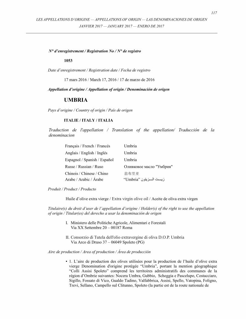
117
LES APPELLATIONS D’ORIGINE — APPELLATIONS OF ORIGIN — LAS DENOMINACIONES DE ORIGEN
JANVIER 2017 — JANUARY 2017 — ENERO DE 2017
N° d’enregistrement / Registration No / N° de registro
1053
Date d’enregistrement / Registration date / Fecha de registro
17 mars 2016 / March 17, 2016 / 17 de marzo de 2016 Appellation d’origine / Appellation of origin / Denominación de origen
UMBRIA
Pays d’origine / Country of origin / País de origen
ITALIE / ITALY / ITALIA Traduction de l'appellation / Translation of the appellation/ Traducción de la denominacion
Français / French / Francés Umbria
Anglais / English / Inglés Umbria
Espagnol / Spanish / Español Umbria
Russe / Russian / Ruso Оливковое масло "Умбрия"
Chinois / Chinese / Chino 翁布里亚
Arabe / Arabic / Árabe “Umbria” زي�������ت ال�������زيتون
Produit / Product / Producto
Huile d’olive extra vierge / Extra virgin olive oil / Aceite de oliva extra virgen
Titulaire(s) du droit d’user de l’appellation d’origine / Holder(s) of the right to use the appellation of origin / Titular(es) del derecho a usar la denominación de origen
I. Ministero delle Politiche Agricole, Alimentari e Forestali Via XX Settembre 20 – 00187 Roma
II. Consorzio di Tutela dell'olio extravergine di oliva D.O.P. Umbria
Via Arco di Druso 37 – 06049 Spoleto (PG)
Aire de production / Area of production / Área de producción ▪ 1. L’aire de production des olives utilisées pour la production de l’huile d’olive extra
vierge Denomination d'origine protègée “Umbria”, portant la mention géographique “Colli Assisi Spoleto” comprend les territoires administratifs des communes de la région d’Ombrie suivantes: Nocera Umbra, Gubbio, Scheggia e Pascelupo, Costacciaro, Sigillo, Fossato di Vico, Gualdo Tadino, Valfabbrica, Assisi, Spello, Vatopina, Foligno, Trevi, Sellano, Campello sul Clitunno, Spoleto (la partie est de la route nationale de
118 LES APPELLATIONS D’ORIGINE — APPELLATIONS OF ORIGIN — LAS DENOMINACIONES DE ORIGEN
JANVIER 2017 — JANUARY 2017 — ENERO DE 2017
Flaminia 3), Scheggino, S. Anatolia di Narco, Vallo di Nera, Cerreto di Spoleto, Preci,
Norcia, Cascia, Poggiodomo, Monteleone di Spoleto, Montefranco, Arrone, Polino, Ferentillo, Terni, Stroncone.
2. L’aire de production des olives utilisées pour la production de l’huile d’olive extra vierge Denomination d'origine protègée “Umbria”, portant la mention géographique “Colli Martani” comprend les territoires administratifs des communes de la région d’Ombrie suivantes: Acquasparta, Spoleto (la partie ouest de la route nationale de Flaminia 3), Massa Martana, Todi, Castel Ritaldi, Giano dell’Umbria, Montefalco, Gualdo Cattaneo, Collazzone, Bevagna, Cannara, Bettona, Deruta, Torgiano, Bastia Umbra. 3. L’aire de production des olives utilisées pour la production de l’huile d’olive extra vierge Denomination d'origine protègée “Umbria”, portant la mention géographique “Colli Amerini” comprend les territoires administratifs des communes de la région d’Ombrie suivantes: Calvi, Otricoli, Narni, Amelia, Penna in Teverina, Giove, Attigliano, Lugnano in Teverina, Alviano, Guardea, San Gemini, Montecastrilli, Avigliano. 4. L’aire de production des olives utilisées pour la production de l’huile d’olive extra vierge Denomination d'origine protègée “Umbria”, portant la mention géographique “Colli del Trasimeno” comprend les territoires administratifs des communes de la région d’Ombrie suivantes: Pérouse, Piegaro, Padano, Panicale, Castiglione del Lago, Magione, Tuoro sul Trasimeno, Passignago sul Trasimeno, Lisciano Niecone, Umbertile, Cittá di Castello, Monte Santa Maria Tiberina, Corciano, Citerna, San Giustino, Montone, Pietralunga. 5. L’aire de production des olives utilisées pour la production de l’huile d’olive extra vierge Denomination d'origine protègée “Umbria”, portant la mention géographique “Colli Orvietani” comprend les territoires administratifs des communes de la région d’Ombrie suivantes: Montecchio, Baschi, Orvieto, Porano, Castel Giorgio, Castel Viscardo, Allerona, Ficulle, Parrano, San Venanzo, Monteleone d’Orvieto, Fabro, Montegabbione, Montecastello di Vibio, Fratta Todina, Marsciano, Cittá della Pieve. /
▪ 1. The production area of the olives used for the production of the Protected
Designation of Origin extra virgin olive oil "Umbria", together with the geographic label "Colli Assisi Spoleto" includes the administrative territories of the following municipalities of Umbria region: Nocera Umbra, Gubbio, Scheggia e Pascelupo, Costacciaro, Sigillo, Fossato di Vico, Gualdo Tadino, Valfabbrica, Assisi, Spello, Valtopina, Foligno, Trevi, Sellano, Campello sul Clitunno, Spoleto, (the east part of the Flaminia state road number 3), Scheggino, S. Anatolia di Narco, Vallo di Nera, Cerreto di Spoleto, Preci, Norcia, Cascia, Poggiodomo, Monteleone di Spoleto, Montefranco, Arrone, Polino, Ferentillo, Terni, Stroncone.
2. The production area of the olives used for the production of the Protected
Designation of Origin extra virgin olive oil "Umbria", together with the geographic label "Colli Martani" includes the administrative territories of the following municipalities of Umbria region: Acquasparta, Spoleto (the west part of the Flaminia state road number 3), Massa Martana, Todi, Castel Ritaldi, Giano dell'Umbria, Montefalco, Gualdo Cattaneo, Collazzone, Bevagna, Cannara, Bettona, Deruta, Torgiano, Bastia Umbra.
119
LES APPELLATIONS D’ORIGINE — APPELLATIONS OF ORIGIN — LAS DENOMINACIONES DE ORIGEN
JANVIER 2017 — JANUARY 2017 — ENERO DE 2017
3. The production area of the olives used for the production of the Protected
Designation of Origin extra virgin olive oil "Umbria", together with the geographic label "Colli Amerini" includes the administrative territories of the following municipalities of Umbria region: Calvi, Otricoli, Narni, Amelia, Penna in Teverina, Giove, Attigliano, Lugnano in Teverina, Alviano, Guardea, San Gemini, Montecastrilli, Avigliano.
4. The production area of the olives used for the production of the Protected
Designation of Origin extra virgin olive oil "Umbria", together with the geographic label "Colli del Trasimeno" includes the administrative territories of the following municipalities of Umbria region: Perugia, Piegaro, Padano, Panicale, Castiglione del Lago, Magione, Tuoro sul Trasimeno, Passignano sul Trasimeno, Lisciano Niecone, Umbertilde, Citta di Castello, Monte Santa Maria Tiberina, Corciano, Citerna, San Giustino, Montone, Pietralunga.
5. The production area of the olives used for the production of the Protected
Designation of Origin extra virgin olive oil "Umbria", together with the geographic label "Colli Orvietani" includes the administrative territories of the following municipalities of Umbria region: Montecchio, Baschi, Orvieto, Porano, Castel Giorgio, Castel Viscardo, Allerona, Ficulle, Parrano, San Venanzo, Monteleone d'Orvieto, Fabro, Montegabbione, Montecastello di Vibio, Fratta Todina, Marsciano, Città della Pieve. /
▪ 1. El área de producción de las olivas que se utilizan para la producción de aceite de
oliva extra virgen Denominación de Origen Protegida “Umbria”, junto con la mención geográfica "Colli Assisi Spoleto", comprende los territorios administrativos de las siguientes regiones municipales de la región de Umbria: Nocera Umbra, Gubbio, Scheggia e Pascelupo, Costacciaro, Sigillo, Fossato di Vico, Gualdo Tadino, Valfabbrica, Assisi, Spello, Valtopina, Foligno, Trevi, Sellano, Campello sul Clitunno, Spoleto,(la parte este de la carretera estatal 3 de Flaminia), Scheggino, S. Anatolia di Narco, Vallo di Nera, Cerreto di Spoleto, Preci, Norcia, Cascia, Poggiodomo, Monteleone di Spoleto, Montefranco, Arrone, Polino, Ferentillo, Terni, Stroncone.
2. El área de producción de las olivas que se utilizan para la producción de aceite de
oliva extra virgen Denominación de Origen Protegida “Umbria”, junto con la mención geográfica "Colli Martani" comprende los territorios administrativos de las siguientes regiones municipales de la región de Umbria: Acquasparta, Spoleto (la parte oeste de la carretera estatal 3 de Flaminia), Massa Martana, Todi, Castel Ritaldi, Giano dell'Umbria, Montefalco, Gualdo Cattaneo, Collazzone, Bevagna, Cannara, Bettona, Deruta, Torgiano, Bastia Umbra.
3. El área de producción de las olivas que se utilizan para la producción de aceite de
oliva extra virgen Denominación de Origen Protegida “Umbria”, junto con la mención geográfica "Colli Amerini" comprende los territorios administrativos de las siguientes regiones municipales de la región de Umbria: Calvi, Otricoli, Narni, Amelia, Penna in Teverina, Giove, Attigliano, Lugnano in Teverina, Alviano, Guardea, San Gemini, Montecastrilli, Avigliano.
120 LES APPELLATIONS D’ORIGINE — APPELLATIONS OF ORIGIN — LAS DENOMINACIONES DE ORIGEN
JANVIER 2017 — JANUARY 2017 — ENERO DE 2017
4. El área de producción de las olivas que se utilizan para la producción de aceite de
oliva extra virgen Denominación de Origen Protegida “Umbria”, junto con la mención geográfica "Colli del Trasimeno" comprende los territorios administrativos de las siguientes regiones municipales de la región de Umbria: Perugia, Piegaro, Padano, Panicale, Castiglione del Lago, Magione, Tuoro sul Trasimeno, Passignano sul Trasimeno, Lisciano Niecone, Umbertilde, Citta di Castello, Monte Santa Maria Tiberina, Corciano, Citerna, San Giustino, Montone, Pietralunga.
5. El área de producción de las olivas que se utilizan para la producción de aceite de
oliva extra virgen Denominación de Origen Protegida “Umbria”, junto con la mención geográfica "Colli Orvietani" comprende los territorios administrativos de las siguientes regiones municipales de la región de Umbria: Montecchio, Baschi, Orvieto, Porano, Castel Giorgio, Castel Viscardo, Allerona, Ficulle, Parrano, San Venanzo, Monteleone d'Orvieto, Fabro, Montegabbione, Montecastello di Vibio, Fratta Todina, Marsciano, Cita della Pieve.
Titre et date des dispositions législatives ou réglementaires ou des décisions judiciaires reconnaissant la protection dans le pays d’origine / Title and date of legislative or administrative provisions or judicial decisions recognizing the protection in the country of origin / Título y fecha de las disposiciones legislativas o administrativas o de las decisiones judiciales en virtud de las cuales se reconoce la protección en el país de origen
▪ Règlement (CE) n° 2325/97 de la Commission du 24 novembre 1997; Règlement d’exécution (UE) N° 226/2014 de la Commission du 7 mars 2014. /
▪ Regulation (EC) no. 2325/97 of the Commission of November 24, 1997; Executive Regulation (EU) No. 226/2014 of the Commission of March 7, 2014. / ▪ Reglamento (CE) N° 2325/97, de la Comisión, de 24 de noviembre de 1997 Reglamento Ejecutivo (UE) N° 226/2014, de la Comisión, de 7 de marzo de 2014.
Langue dans laquelle le Bureau international a reçu la demande internationale / Language in which the International Bureau received the international application / Idioma en el que la Oficina Internacional recibió la solicitud internacional
Anglais / English / Inglés
121
LES APPELLATIONS D’ORIGINE — APPELLATIONS OF ORIGIN — LAS DENOMINACIONES DE ORIGEN
JANVIER 2017 — JANUARY 2017 — ENERO DE 2017
N° d’enregistrement / Registration No / N° de registro
1054
Date d’enregistrement / Registration date / Fecha de registro
17 mars 2016 / March 17, 2016 / 17 de marzo de 2016 Appellation d’origine / Appellation of origin / Denominación de origen
ARANCIA DI RIBERA
Pays d’origine / Country of origin / País de origen
ITALIE / ITALY / ITALIA Traduction de l'appellation / Translation of the appellation/ Traducción de la denominacion
Français / French / Francés Orange de Ribera
Anglais / English / Inglés Ribera oranges
Espagnol / Spanish / Español Naranja de Ribera
Russe / Russian / Ruso Апельсины "Рибера"
Chinois / Chinese / Chino 利贝拉橙子
Arabe / Arabic / Árabe “Arancia di Ribera” برتق�����������ال
Produit / Product / Producto
Oranges / Oranges / Naranjas
Titulaire(s) du droit d’user de l’appellation d’origine / Holder(s) of the right to use the appellation of origin / Titular(es) del derecho a usar la denominación de origen
I. Ministero delle Politiche Agricole, Alimentari e Forestali Via XX Settembre 20 – 00187 Roma
II. Consorzio di Tutela Arancia di Ribera DOP
c/o Centro Direzionale per l'Agricoltura –Via Quasimodo – 92016 – Ribera (AG)
Aire de production / Area of production / Área de producción ▪ L’aire de production de l’ “Arancia di Ribera” couvre les communes de Bivona, Burgio,
Calamonaci, Caltabellotta, Cattolica Eraclea, Cianciana, Lucca Sicula, Menfi, Montallegro, Ribera, Sciacca, Siculiana et Villafranca Sicula dans la province d’Agrigente et la commune de Chiusa Sclafani dans la province de Palerme. /
122 LES APPELLATIONS D’ORIGINE — APPELLATIONS OF ORIGIN — LAS DENOMINACIONES DE ORIGEN
JANVIER 2017 — JANUARY 2017 — ENERO DE 2017
▪ The production area of the "Arancia di Ribera" includes the areas of the municipalities
of Bivona, Burgio, Calamonaci, Caltabellotta, Cattolica Eraclea, Cianciana, Lucca Sicula, Menfi, Montallegro, Ribera, Sciacca, Siculiana and Villafranca Sicula in the province of Agrigento and the municipality of Chiusa Sclafani in the province of Palermo. /
▪ El área de producción de la “Arancia di Ribera” comprende las áreas de los municipios de Bivona, Burgio, Calamonaci, Caltabellotta, Cattolica Eraclea, Cianciana, Lucca Sicula, Menfi, Montallegro, Ribera, Sciacca, Siculiana y Villafranca Sicula localizados en la provincia de Agrigento y el municipio de Chiusa Sclafani en la provincia de Palermo.
Titre et date des dispositions législatives ou réglementaires ou des décisions judiciaires reconnaissant la protection dans le pays d’origine / Title and date of legislative or administrative provisions or judicial decisions recognizing the protection in the country of origin / Título y fecha de las disposiciones legislativas o administrativas o de las decisiones judiciales en virtud de las cuales se reconoce la protección en el país de origen
▪ Règlement (UE) n° 95/2011 de la Commission du 3 février 2011. /
▪ Regulation (EU) No. 95/2011 of the Commission of February 3, 2011. / ▪ Reglamento (UE) Nº 95/2011 de la Comisión, de 3 de febrero de 2011.
Langue dans laquelle le Bureau international a reçu la demande internationale / Language in which the International Bureau received the international application / Idioma en el que la Oficina Internacional recibió la solicitud internacional
Anglais / English / Inglés
123
LES APPELLATIONS D’ORIGINE — APPELLATIONS OF ORIGIN — LAS DENOMINACIONES DE ORIGEN
JANVIER 2017 — JANUARY 2017 — ENERO DE 2017
N° d’enregistrement / Registration No / N° de registro
1055
Date d’enregistrement / Registration date / Fecha de registro
17 mars 2016 / March 17, 2016 / 17 de marzo de 2016 Appellation d’origine / Appellation of origin / Denominación de origen
NOCCIOLA DI GIFFONI
Pays d’origine / Country of origin / País de origen
ITALIE / ITALY / ITALIA Traduction de l'appellation / Translation of the appellation/ Traducción de la denominacion
Français / French / Francés Noisette de Giffoni
Anglais / English / Inglés Giffoni hazelnuts
Espagnol / Spanish / Español Avellana de Giffoni
Russe / Russian / Ruso Лесной орех (фундук) "Джиффони"
Chinois / Chinese / Chino 吉弗尼棒子
Arabe / Arabic / Árabe “Nocciola di Giffoni” بن�������دق
Produit / Product / Producto
Noisette / Hazelnut / Avellana
Titulaire(s) du droit d’user de l’appellation d’origine / Holder(s) of the right to use the appellation of origin / Titular(es) del derecho a usar la denominación de origen
I. Ministero delle Politiche Agricole, Alimentari e Forestali Via XX Settembre 20 – 00187 Roma
II. Consorzio di Tutela Nocciola di Giffoni I.G.P.
Via Valentino Fortunato – Zona PIP snc – 84095 GIFFONI VALLE PIANA (SA) Aire de production / Area of production / Área de producción
▪ L’aire de production comprend une partie du territoire de la province de Salerne, ainsi
que l’intégralité du territoire des communes suivantes: Giffoni Valle Piana, Giffoni sei Casali, San Cipriano Picentino, Pisciano, Galvanico, Castiglione dei Genovesi, Montecorvino Rovella et une partie des communes de Baronissi, Montecorvino Pugliano, Olevano sul Tusciano, San Mango Piemonte, Acerno. /
124 LES APPELLATIONS D’ORIGINE — APPELLATIONS OF ORIGIN — LAS DENOMINACIONES DE ORIGEN
JANVIER 2017 — JANUARY 2017 — ENERO DE 2017
▪ The production area includes part of the territory of the province of Salerno and includes the whole territory of the following municipalities: Giffoni Valle Piana, Giffoni sei Casali, San Cipriano Picentino, Pisciano, Galvanico, Castiglione dei Genovesi, Montecorvino Rovella and partially the municipalities of Baronissi, Montecorvino Pugliano, Olevano sul Tusciano, San Mango Piemonte, Acerno. /
▪ La zona de producción comprende parte del territorio de la provincia de Salerno, así como la totalidad del territorio de los siguientes municipios: Giffoni Valle Piana, Giffoni sei Casali, San Cipriano Picentino, Pisciano, Galvanico, Castiglione dei Genovesi, Montecorvino Rovella y parte de los municipios de Baronissi, Montecorvino Pugliano, Olevano sul Tusciano, San Mango Piemonte, Acerno.
Titre et date des dispositions législatives ou réglementaires ou des décisions judiciaires reconnaissant la protection dans le pays d’origine / Title and date of legislative or administrative provisions or judicial decisions recognizing the protection in the country of origin / Título y fecha de las disposiciones legislativas o administrativas o de las decisiones judiciales en virtud de las cuales se reconoce la protección en el país de origen
▪ Règlement (CE) n° 2325/97 de la Commission du 24 novembre 1997; Règlement (CE) n° 1257/2006 de la Commission du 21 août 2006; Règlement d’exécution (UE) n° 171/2014 de la Commission du 20 février 2014. / ▪ Regulation (EC) No. 2325/97 of the Commission of November 24, 1997; Regulation (EC) No. 1257/2006 of the Commission of August 21, 2006; Executive Regulation (EU) No. 171/2014 of the Commission of February, 20 2014. / ▪ Reglamento (CE) Nº 2325/97 de la Comisión, de 24 de noviembre de 1997; Reglamento (CE) Nº 1257/2006 de la Comisión, de 21 de agosto de 2006; Reglamento de Ejecución (UE) Nº 171/2014 de la Comisión, de 20 de febrero de 2014.
Langue dans laquelle le Bureau international a reçu la demande internationale / Language in which the International Bureau received the international application / Idioma en el que la Oficina Internacional recibió la solicitud internacional
Anglais / English / Inglés
125
LES APPELLATIONS D’ORIGINE — APPELLATIONS OF ORIGIN — LAS DENOMINACIONES DE ORIGEN
JANVIER 2017 — JANUARY 2017 — ENERO DE 2017
N° d’enregistrement / Registration No / N° de registro
1056
Date d’enregistrement / Registration date / Fecha de registro
17 mars 2016 / March 17, 2016 / 17 de marzo de 2016 Appellation d’origine / Appellation of origin / Denominación de origen
RAGUSANO
Pays d’origine / Country of origin / País de origen
ITALIE / ITALY / ITALIA Traduction de l'appellation / Translation of the appellation/ Traducción de la denominacion
Français / French / Francés Fromage Ragusano
Anglais / English / Inglés Ragusano Cheese
Espagnol / Spanish / Español Queso Ragusano
Russe / Russian / Ruso Полутвердый сыр "Раrузано"
Chinois / Chinese / Chino 拉古萨农奶酪
Arabe / Arabic / Árabe “Ragusano”جب�����ن
Produit / Product / Producto
Fromage / Cheese / Queso
Titulaire(s) du droit d’user de l’appellation d’origine / Holder(s) of the right to use the appellation of origin / Titular(es) del derecho a usar la denominación de origen
I. Ministero delle Politiche Agricole, Alimentari e Forestali Via XX Settembre 20 – 00187 Roma
II. Consorzio per la tutela del formaggio "Ragusano dop"
Viale Delle Americhe 13 – 97100 Ragusa
Aire de production / Area of production / Área de producción ▪ L’aire de production du "Ragusano" telle qu’elle a été délimitée selon le COMITATO
NAZIONALE FORMAGGI (Comité national des fromages) le 18/05/1994, comprend l’ensemble de la province de Raguse ainsi que les territoires avoisinants des communes de Palazzolo Acreide, Noto et Rosolini dans la province de Syracuse.
126 LES APPELLATIONS D’ORIGINE — APPELLATIONS OF ORIGIN — LAS DENOMINACIONES DE ORIGEN
JANVIER 2017 — JANUARY 2017 — ENERO DE 2017
Le territoire, qui s’étend sur environ 2400 km2, est délimité par la province de Caltanissetta à l’ouest, par la province de Catane au nord et par d’autres territoires de la province de Syracuse à l’est et au nord-est. Les territoires de Palazzolo Acreide et Noto font partie de la zone la plus haute des contreforts des monts Hybléens. La partie nord du territoire de Rosolini traverse les vallées des fleuves Tellaro et Tellesimo et s’insère dans la province de Raguse. /
▪ The production area of "Ragusano", as bounded in the opinion of COMITATO
NAZIONALE FORMAGGI (National Cheese Committee) on 18/05/1994, includes the entire province of Ragusa and the bordering territories of the municipalities of Palazzolo Acreide, Noto and Rosolini, in the province of Siracusa.
The territory, around 2400 square kilometers extended, is bounded by the province of Caltanissetta on the west, by the province of Catania on the north and by other territories of the province of Siracusa on the east north-east. While the territories of Palazzolo Acreide and Noto are part of the highest part of the upland of the lblei Mountains. The territory of Rosolini, for the northern part crosses the rivers Tellaro and Tellesimo valley and slots inside de province of Ragusa. /
▪ El área de producción del queso "Ragusano", como señalaba el COMITATO
NAZIONALE FORMAGGI (Comisión Nacional del Queso) el 18/05/1994, incluye toda la provincia de Ragusa y los territorios limítrofes de los municipios de Palazzolo Acreide, Noto y Rosolini, en la provincia de Siracusa.
El territorio, de aproximadamente 2.400 kilómetros cuadrados, comprende la provincia de Caltanissetta al oeste, la provincia de Catania al norte y otros territorios de la provincia de Siracusa al este-noreste. Los territorios de Palazzolo Acreide y Noto forman parte de las zonas más elevadas de los Montes Ibleos. El territorio de Rosolini, en la zona norte, cruza los ríos Tellaro y Tellesimo y se adentra hasta el territorio de Ragusa.
Titre et date des dispositions législatives ou réglementaires ou des décisions judiciaires reconnaissant la protection dans le pays d’origine / Title and date of legislative or administrative provisions or judicial decisions recognizing the protection in the country of origin / Título y fecha de las disposiciones legislativas o administrativas o de las decisiones judiciales en virtud de las cuales se reconoce la protección en el país de origen
▪ Règlement (CE) n° 1263/96 de la Commission du 1er juillet 1996. / ▪ Regulation (EC) No. 1263/96 of the Commission of July 1, 1996. / ▪ Reglamento (CE) N° 1263/96, de la Comisión, de 1 de julio de 1996.
Langue dans laquelle le Bureau international a reçu la demande internationale / Language in which the International Bureau received the international application / Idioma en el que la Oficina Internacional recibió la solicitud internacional
Anglais / English / Inglés
127
LES APPELLATIONS D’ORIGINE — APPELLATIONS OF ORIGIN — LAS DENOMINACIONES DE ORIGEN
JANVIER 2017 — JANUARY 2017 — ENERO DE 2017
N° d’enregistrement / Registration No / N° de registro
1057
Date d’enregistrement / Registration date / Fecha de registro
17 mars 2016 / March 17, 2016 / 17 de marzo de 2016 Appellation d’origine / Appellation of origin / Denominación de origen
AGLIO BIANCO POLESANO
Pays d’origine / Country of origin / País de origen
ITALIE / ITALY / ITALIA Traduction de l'appellation / Translation of the appellation/ Traducción de la denominacion
Français / French / Francés Ail blanc Polesano
Anglais / English / Inglés Polesano white garlic
Espagnol / Spanish / Español Ajo blanco Polesano
Russe / Russian / Ruso Белый чеснок "Полезано"
Chinois / Chinese / Chino 伯乐萨侬臼蒜
Arabe / Arabic / Árabe “Aglio Bianco Polesano” ث�����وم
Produit / Product / Producto
Ail / Garlic / Ajo
Titulaire(s) du droit d’user de l’appellation d’origine / Holder(s) of the right to use the appellation of origin / Titular(es) del derecho a usar la denominación de origen
I. Ministero delle Politiche Agricole, Alimentari e Forestali Via XX Settembre 20 – 00187 Roma
II. Consorzio di tutela dell'Aglio bianco polesano Dop
Piazza Garibaldi 6 – 45100 Rovigo
Aire de production / Area of production / Área de producción ▪ L’aire de production de l’Aglio bianco Polesano (Ail blanc Polesano) couvre les
communes suivantes de la région du Polésine, situées dans la province de Rovigo: Adria, Arquà Polesine, Bosaro, Canaro, Canda, Castelguglielmo, Ceregnano, Costa di Rovigo, Crespino, Fiesso Umbertiano, Frassinelle Polesine, Fratta Polesine, Gavello, Guarda Veneta, Lendinara, Lusia, Occhiobello, Papozze, Pettorazza Grimani, Pincara,
128 LES APPELLATIONS D’ORIGINE — APPELLATIONS OF ORIGIN — LAS DENOMINACIONES DE ORIGEN
JANVIER 2017 — JANUARY 2017 — ENERO DE 2017
Polesella, Pontecchio Polesine, Rovigo, San Bellino, San Martino di Venezze,
Villadose, Villamarzana, Villanova del Ghebbo, Villanova Marchesana. /
▪ The production area of Aglio Bianco Polesano includes the following municipalities of the Polesine area, located in the province of Rovigo: Adria, Arquà Polesine, Bosaro, Canaro, Canda, Castelguglielmo, Ceregnano, Costa di Rovigo, Crespino, Fiesso Umbertiano, Frassinelle Polesine, Fratta Polesine, Gavello, Guarda Veneta, Lendinara, Lusia, Occhiobello, Papozze, Pettorazza Grimani, Pincara, Polesella, Pontecchio Polesine, Rovigo, San Bellino, San Martino di Venezze, Villadose, Villamarzana, Villanova del Ghebbo, Villanova Marchesana. /
▪ El área de producción de Aglio bianco Polesano (Ajo blanco Polesano) comprende los
municipios siguientes del área de Polesina, localizada en la provincia de Rovigo: Adria, Arquà Polesine, Bosaro, Canaro, Canda, Castelguglielmo, Ceregnano, Costa di Rovigo, Crespino, Fiesso Umbertiano, Frassinelle Polesine, Fratta Polesine, Gavello, Guarda Veneta, Lendinara, Lusia, Occhiobello, Papozze, Pettorazza Grimani, Pincara, Polesella, Pontecchio Polesine, Rovigo, San Bellino, San Martino di Venezze, Villadose, Villamarzana, Villanova del Ghebbo, Villanova Marchesana.
Titre et date des dispositions législatives ou réglementaires ou des décisions judiciaires reconnaissant la protection dans le pays d’origine / Title and date of legislative or administrative provisions or judicial decisions recognizing the protection in the country of origin / Título y fecha de las disposiciones legislativas o administrativas o de las decisiones judiciales en virtud de las cuales se reconoce la protección en el país de origen
▪ Règlement (CE) n° 1175/2009 de la Commission du 30 novembre 2009 ; Règlement d’exécution (UE) n° 2015/197 de la Commission du 05 février 2015. / ▪ Regulation (EC) No. 1175/2009 of the Commission of November 30, 2009; Executive Regulation (EU) No. 2015/197 of the Commission of February 05, 2015. / ▪ Reglamento (CE) Nº 1175/2009 de la Comisión, de 30 de noviembre de 2009; Reglamento de Ejecución (UE) Nº 2015/197 de la Comisión, de 5 de febrero de 2015.
Langue dans laquelle le Bureau international a reçu la demande internationale / Language in which the International Bureau received the international application / Idioma en el que la Oficina Internacional recibió la solicitud internacional
Anglais / English / Inglés
129
LES APPELLATIONS D’ORIGINE — APPELLATIONS OF ORIGIN — LAS DENOMINACIONES DE ORIGEN
JANVIER 2017 — JANUARY 2017 — ENERO DE 2017
N° d’enregistrement / Registration No / N° de registro
1058
Date d’enregistrement / Registration date / Fecha de registro
17 mars 2016 / March 17, 2016 / 17 de marzo de 2016 Appellation d’origine / Appellation of origin / Denominación de origen
BITTO
Pays d’origine / Country of origin / País de origen
ITALIE / ITALY / ITALIA Traduction de l'appellation / Translation of the appellation/ Traducción de la denominacion
Français / French / Francés Fromage Bitto
Anglais / English / Inglés Bitto Cheese
Espagnol / Spanish / Español Queso Bitto
Russe / Russian / Ruso Вареный прессованный сыр из коровьего Молока «Битrо» из области Ломбардия
Chinois / Chinese / Chino 比多奶酪
Arabe / Arabic / Árabe “Bitto” جب�����ن
Produit / Product / Producto
Fromage / Cheese / Queso
Titulaire(s) du droit d’user de l’appellation d’origine / Holder(s) of the right to use the appellation of origin / Titular(es) del derecho a usar la denominación de origen
I. Ministero delle Politiche Agricole, Alimentari e Forestali
Via XX Settembre 20 – 00187 Roma II. Consorzio per la Tutela dei Formaggi Valtellina Casera e Bitto
Via Bormio 26 – 23100 Sondrio
Aire de production / Area of production / Área de producción ▪ L’aire d’origine du lait destiné à la transformation, à la production et à l’affinage du
fromage “Bitto” couvre l’ensemble de la région de la province de Sondrio, les pâturages de montagne des territoires adjacents des communes suivantes de l’Alta Val Brembaba dans la province de Bergame: Averara, Carona, Cusio, Foppolo, Mezzoldo, Piazzatorre, Santa Brigida, Valleve et les pâturages de montagne dénommés Varrone,
130 LES APPELLATIONS D’ORIGINE — APPELLATIONS OF ORIGIN — LAS DENOMINACIONES DE ORIGEN
JANVIER 2017 — JANUARY 2017 — ENERO DE 2017
Artino et Lareggio des territoires adjacents des communes d’Introbio et de Premana
dans la province de Lecco. /
▪ The area of origin of the milk destined to the processing, production and aging of "Bitto" cheese includes the whole region of Sondrio province, the mountain pastures of adjacent territories of the following municipalities of Alta Val Brembana in the province of Bergamo: Averara, Carona, Cusio, Foppolo, Mezzoldo, Piazzatorre, Santa Brigida, Valleve and the mountain pastures called Varrone, Artino and Lareggio of adjacent territories in the municipalities of Introbio and Premana in the province of Lecco. /
▪ El área de origen de la leche destinada al procesamiento, a la producción y al curado
del queso “Bitto” incluye todo el territorio de la provincia de Sondrio, los pastizales montañosos de los territorios limítrofes de las siguientes municipalidades de Alta Valle Brembana en la provincia de Bérgamo: Averara, Carona, Cusio, Foppolo, Mezzoldo, Piazzatorre, Santa Brigida, Valleve y los pastizales montañosos denominados Varrone, Artino y Lareggio de los territorios limítrofes que se encuentran en las municipalidades de Introbio y Premana en la provincia de Lecco.
Titre et date des dispositions législatives ou réglementaires ou des décisions judiciaires reconnaissant la protection dans le pays d’origine / Title and date of legislative or administrative provisions or judicial decisions recognizing the protection in the country of origin / Título y fecha de las disposiciones legislativas o administrativas o de las decisiones judiciales en virtud de las cuales se reconoce la protección en el país de origen
▪ Règlement (CE) n° 1107/96 de la Commission du 12 juin 1996; Réglement (CE) n° 1138/2009 de la Commission du 25 novembre 2009. / ▪ Regulation (EC) No. 1107/96 of the Commission of June 12, 1996; Regulation (EC) No. 1138/2009 of the Commission of November 25, 2009. / ▪ Reglamento (CE) Nº 1107/96 de la Comisión, de 12 de junio de 1996; Reglamento (CE) Nº 1138/2009 de la Comisión, de 25 de noviembre de 2009.
Langue dans laquelle le Bureau international a reçu la demande internationale / Language in which the International Bureau received the international application / Idioma en el que la Oficina Internacional recibió la solicitud internacional
Anglais / English / Inglés
131
LES APPELLATIONS D’ORIGINE — APPELLATIONS OF ORIGIN — LAS DENOMINACIONES DE ORIGEN
JANVIER 2017 — JANUARY 2017 — ENERO DE 2017
N° d’enregistrement / Registration No / N° de registro
1059
Date d’enregistrement / Registration date / Fecha de registro
17 mars 2016 / March 17, 2016 / 17 de marzo de 2016 Appellation d’origine / Appellation of origin / Denominación de origen
CHIANTI CLASSICO
Pays d’origine / Country of origin / País de origen
ITALIE / ITALY / ITALIA Traduction de l'appellation / Translation of the appellation/ Traducción de la denominacion
Français / French / Francés Chianti Classico
Anglais / English / Inglés Chianti Classico
Espagnol / Spanish / Español Chianti Classico
Russe / Russian / Ruso Вино Кьянти Классикo
Chinois / Chinese / Chino 经典基安蒂
Arabe / Arabic / Árabe “Chianti Classico” نبي����������ذ
Produit / Product / Producto
Vin / Wine / Vino
Titulaire(s) du droit d’user de l’appellation d’origine / Holder(s) of the right to use the appellation of origin / Titular(es) del derecho a usar la denominación de origen
I. Ministero delle Politiche Agricole, Alimentari e Forestali
Via XX Settembre 20 – 00187 Roma
II. Consorzio Vino Chianti Classico Via Pianigiani 9 – Radda in Chianti (SI)
Aire de production / Area of production / Área de producción
▪ L’aire de production du vin "Chianti Classico" est la région délimitée par le Décret
interministériel du 31 juillet 1932, confirmé par l’article 5 du DPR [Décret du Président de la République italienne] 930 du 12.07.1963, par l’article 3 du DPR du 9 août 1967, par l’article 3 du DPR du 2 juillet 1984 et par l’article 5 de la loi 164 du 10.02.1992, indépendamment régi par la loi de l’article 5 de la loi 164/92 précitée. Cette région est ainsi délimitée: partant de la description de la limite de la partie de cette aire qui
132 LES APPELLATIONS D’ORIGINE — APPELLATIONS OF ORIGIN — LAS DENOMINACIONES DE ORIGEN
JANVIER 2017 — JANUARY 2017 — ENERO DE 2017
appartient à la province de Sienne, le point de départ est considéré comme étant l’endroit où la frontière entre les deux provinces de Sienne et Arezzo est traversée par le Borro Ambrella della Vena près de Pancole sur la commune de Castelnuovo Berardenga.
A partir de ce point, la frontière suit le cours de l’Ambra et son affluent, non nommé, jusqu’à l’exploitation agricole de Ciarpella, puis un chemin de mulet qui mène à l’exploitation agricole de Casa al Frate. A partir de là, elle suit une ligne virtuelle jusqu’au mont Ombrone (298m d’altitude). Puis, à partir de là, en suivant un chemin de mulet, elle parvient à une altitude de 257m, où elle arrive à une route rurale qui mène à la route de Castelnuovo Berardenga. Elle suit ensuite la route précitée jusqu’à une altitude de 354m. Partant de là, elle longe le fossé de Malena Morta jusqu’à la jonction de Borro Spugnaccio; puis, toujours le long du fossé de Malena Morta précité jusqu’à Pialli (227m d’altitude). Elle passe par un court chemin le fossé de Malena Viva, puis tourne en direction d’une ligne virtuelle, traversant S. Lucia (252m et 265m d’altitude), en direction du cours d’eau Arbia.
Une fois ce cours d’eau, atteint, la frontière se poursuit le long de la limite administrative entre les communes de Sienne et de Castelnuovo Berardenga.
A partir de là, la frontière de l’aire correspond aux limites administratives de Sienne, Castelnuovo Berardenga, Castellina, Monteriggioni et Poggibonsi, jusqu’à ce qu’elle rencontre, au niveau de Borro di Granaio, la frontière de la province de Florence, qu’elle suit jusqu’à l’exploitation agricole de Le Valli. Puis elle poursuit le long de la route communale, bordant S. Giorgio et les sources de Cinciano et continue jusqu’à ce qu’elle rejoigne à nouveau la limite de la province, qui est également la limite entres les communes de Poggibonsi et Barberino, puis elle rejoint le cours d’eau Drove en pénétrant dans la province de Florence.
A cet endroit, la description de la frontière de la partie de cette aire, qui appartient à la province de Florence, est connue. Par un premier chemin, la frontière précitée suit le cours du Drove jusqu’à Mulino della Chiara, où elle rejoint la limite administrative entre les communes de Tavarnelle et Barberino, qu’elle suit par un court chemin, puis tourne légèrement vers l’est le long d’un autre petit cours d’eau, traversant Ca’ Biricucci et Belvedere, jusqu’à rejoindre immédiatement après la route de S. Donato – Tavernelle qui se poursuit jusqu’à Morocco; ensuite, par une ligne virtuelle qui traverse Figlinella, elle atteint Sambuca, où elle rejoint le cours du Pesa.
Toujours en suivant le cours d’eau, la frontière correspond par un premier chemin à la limite administrative entre les communes de S. Casciano Val di Pesa et Tavarnelle; puis elle rejoint à nouveau le cours d’eau après Ponte Rotto. A partir de cet endroit, la frontière de l’aire correspond aux limites administratives des communes de San Casciano et Greve.
A cet endroit, elle retourne dans la province de Sienne et la frontière de l’aire du Chianti Classico correspond à la frontière administrative des communes de Radda in Chianti et Gaiole et par un petit chemin de Castelnuovo Berardenga, jusqu’à ce qu’elle rejoigne le point de départ de la description de cette aire. /
▪ The production area of "Chianti Classico" wine is the region delimited by
Interministerial Decree July 31, 1932, confirmed by art. 5 of DPR [Decree of the President of the Italian Republic] 930 of 12.07.1963, by art. 3 of DPR August 9, 1967, by art. 3 of DPR July 2, 1984 and by art. 5 of Law 164 of 10.02.1992, independently regulated under the law of mentioned art. 5 of Law 164/92. Such region is in this manner delimited: starting from the description of the border of the portion of this area which belongs to the province of Siena, the point of beginning is taken at the point in which the border between the two provinces of Siena and Arezzo is crossed by Borro Ambrella della Vena near Pancole in the municipality of Castelnuovo Berardenga.
133
LES APPELLATIONS D’ORIGINE — APPELLATIONS OF ORIGIN — LAS DENOMINACIONES DE ORIGEN
JANVIER 2017 — JANUARY 2017 — ENERO DE 2017
From this point, the border proceeds along Ambra stream and his unmentioned tributary, until the farm of Ciarpella, then the mule track leads which leads to the farm of Casa al Frate. From here, it follows a virtual line up to the Ombrone (298m height). From here, proceeding along a mule track, it reaches 257m height, where it meets a rural road which leads on the road for Castelnuovo Berardenga. It follows up the above-mentioned road until 354m height. From here, it proceeds along the Malena Morta ditch until its confluence with Borro Spugnaccio; then, still along the above-mentioned Malena Morta ditch until Pialli (227m height). It precedes for a short trail the Malena Viva ditch, then it turns to a virtual line, crossing S. Lucia (252m and 265m height), towards Arbia stream. Once this stream reached, the border follows it up along the administrative limit between the municipalities of Siena and Castelnuovo Berardenga. From here, the area border corresponds to the administrative limits of Siena, Castelnuovo Berardenga, Castellina, Monteriggioni and Poggibonsi, until it meets, in correspondence of Borro di Granaio, the border of the province of Firenze, which it follows until the farm of Le Valli. Thus, it proceeds along the municipal road, touching S. Giorgio and the Cinciano springs and continues until it meets again the provincial limit, which is also the one between the municipalities of Poggibonsi and Barberino, then it meets the Drove stream entering the province of Firenze. At this point, the description of the border of the portion of this area, which belongs to the province of Firenze, is made. For a first trail, the above-mentioned border follows the Drove streams until the Mulino della Chiara, where it meets the administrative limit between the municipalities of Tavarnelle and Barberino, which it follows for a short trail, then it slightly curves toward East along another small stream, passing through Ca' Biricucci and Belvedere, until meeting immediately after the S. Donato – Tavemelle road which follows until Morocco; then, with a virtual line crossing Figlinella, it reaches Sambuca, where it meets Pesa stream. Still following the stream flow, the border corresponds for a first trail to the administrative limit between the municipalities of S. Casciano Val di Pesa and Tavarnelle; then it meets again the stream after Ponte Rotto. From this point, the border of the area corresponds to the administrative limits of the municipalities of San Casciano and Greve. Here, it returns in the province of Siena and the border of the area of Chianti Classico corresponds to the administrative one of the municipalities of Radda in Chianti and Gaiole, and for a small trail of Castelnuovo Berardenga, until it reaches the starting point of the description of this area. /
▪ El área de producción del vino con la denominación “Chianti Classico” se reserva a la
región delimitada mediante Decreto Interministerial de 31 de julio de 1932, confirmada con el Art. 5 del DPR [Decreto del Presidente de la República de Italia] 930 de 12 de julio de 1963, con el Art. 3 del DPR de 9 de agosto de 1967, con el Art. 3 del DPR de 2 de julio de 1984 y con el Art. 5 de la Ley 164 de 10 de febrero de 1992, regulada de manera autónoma conforme a lo estipulado por el Art. 5 de la Ley 164/92. Dicha región se delimita de la siguiente manera: comenzando por la descripción de la linde de esta área, que pertenece a la provincia de Siena, se toma como referencia el punto en que el Borro Ambrella della Vena cruza la linde entre las dos provincias de Siena y Arezzo, cerca de Pancole en el municipio de Castelnuovo Berardenga.
A partir de este punto, la linde bordea el arroyo de Ambra y su afluente no denominado, hasta la granja de Ciarpella, y se toma un camino de herradura que lleva hasta la granja de Casa al Frate. Desde aquí sigue una línea virtual hasta Ombrone (a 298 m de altura), prosigue por un camino de herradura a 257 m de altura, para desembocar en una carretera rural que conduce a Castelnuovo Berardenga. Siguiendo
134 LES APPELLATIONS D’ORIGINE — APPELLATIONS OF ORIGIN — LAS DENOMINACIONES DE ORIGEN
JANVIER 2017 — JANUARY 2017 — ENERO DE 2017
la carretera antes mencionada a 354 m de altura, bordea la acequia de Malena Morta
hasta su confluencia con Borro Spugnaccio; sin desviarse llega a Pialli (227 m de altura), atraviesa una trocha por la acequia de Malena Viva, hace un giro virtual y cruza S. Lucia (a 252 m y 265 m de altura), hacia el arroyo de Arbia. Desde aqui la linde sigue el límite administrativo entre los municipios de Siena y Castelnuovo Berardenga. A partir de este punto, la zona limítrofe coincide con los límites administrativos de Siena, Castelnuovo Berardenga, Castellina, Monteriggioni y Poggibonsi, hasta la intersección con Borro di Granaio, la linde de la provincia de Florencia, que continúa hasta la granja de Le Valli. La línea fronteriza continúa por la carretera municipal cerca de S. Giorgio y de los manantiales de Cinciano hasta encontrar nuevamente la linde provincial que separa los municipios de Poggibonsi y Barberino, para luego encontrarse con el arroyo Drove que entra en la provincia de Florencia. En este punto comienza la linde del territorio de esta área, que pertenece a la provincia de Florencia. En el primer tramo, la linde antes mencionada sigue el arroyo Drove hasta Mulino della Chiara, en el límite administrativo que separa los municipios de Tavernelle y Barberino, prosigue por una trocha, luego se desvía ligeramente al este bordeando otro arroyuelo y finalmente pasa por Ca’ Biricucci y Belvedere hasta encontrar inmediatamente después la carretera S. Donato – Tavernelle que conduce a Morocco; siguiendo una línea virtual que pasa por Figlinella, llega a Sambuca, en donde encuentra el arroyo Pesa. Sin desviarse, cruza por un corto trecho el límite administrativo que separa los municipios de S. Casciano Val di Pesa y Tavernelle y después del Ponte Rotto se encuentra nuevamente con el arroyo. A partir de este lugar, la linde del área coincide con los límites administrativos de los municipios de San Casciano y Greve. Desde aquí regresa por la provincia de Siena, en donde la linde del área del Chianti Classico se cruza con la de los municipios de Radda en Chianti y Gaiole, se desvía por una trocha de Castelnuovo Berardenga, hasta llegar al punto de partida de la descripción de esta área.
Titre et date des dispositions législatives ou réglementaires ou des décisions judiciaires reconnaissant la protection dans le pays d’origine / Title and date of legislative or administrative provisions or judicial decisions recognizing the protection in the country of origin / Título y fecha de las disposiciones legislativas o administrativas o de las decisiones judiciales en virtud de las cuales se reconoce la protección en el país de origen
▪ Décret du Président de la République italienne 09.08.1967 G.U. (Journal Officiel) 217 - 30.08.1967;
Décret du Président de la République italienne 02.07.1984 G.U. (Journal Officiel) 290 - 20.10.1984; Décret ministériel 08.01.1996 G.U. (Journal Officiel) 25 - 31.01.1996; Décret ministériel 05.08.1996 G.U. (Journal Officiel) 219 s. 18.09.1996; Décret ministériel 15.03.1999 G.U. (Journal Officiel) 65 - 19.03.1999; Décret ministériel 08.08.2001 G.U. (Journal Officiel) 205 - 04.09.2001; Décret ministériel 20.09.2001 G.U. (Journal Officiel) 229 - 02.10.2001; Décret ministériel 16.05.2002 G.U. (Journal Officiel) 127- 01.06.2002; Décret ministériel 15.09.2005 G.U. (Journal Officiel) 227 - 21.09.2005; Décret ministériel 25.01.2007 G.U. (Journal Officiel) 30 - 6.02.2007; Décret ministériel 10.12.2007 G.U. (Journal Officiel) 290 - 14.12.2007; Décret ministériel 10.06.2010 G.U. (Journal Officiel) 150 - 30.06.2010; Décret ministériel 30.11.2011 G.U. (Journal Officiel) 295 - 20.12.2011. /
135
LES APPELLATIONS D’ORIGINE — APPELLATIONS OF ORIGIN — LAS DENOMINACIONES DE ORIGEN
JANVIER 2017 — JANUARY 2017 — ENERO DE 2017
▪ Decree of the President of the Italian Republic 09.08.1967 G.U. (Official Journal) 217 -30.08.1967;
Decree of the President of the Italian Republic 02.07.1984 G.U. (Official Journal) 290 - 20.10.1984; Ministerial Decree 08.01.1996 G.U. (Official Journal) 25 - 31.01.1996; Ministerial Decree 05.08.1996 G.U. (Official Journal) 219 s. 18.09.1996; Ministerial Decree 15.03.1999 G.U. (Official Journal) 65 - 19.03.1999; Ministerial Decree 08.08.2001 G.U. (Official Journal) 205 - 04.09.2001; Ministerial Decree 20.09.2001 G.U. (Official Journal) 229 - 02.10.2001; Ministerial Decree 16.05.2002 G.U. (Official Journal) 127- 1.06.2002; Ministerial Decree 15.09.2005 G.U. (Official Journal) 227 - 21.09.2005; Ministerial Decree 25.01.2007 G.U. (Official Journal) 30 - 06.02.2007; Ministerial Decree 10.12.2007 G.U. (Official Journal) 290 - 14.12.2007; Ministerial Decree 10.06.2010 G.U. (Official Journal) 150 - 30.06.2010; Ministerial Decree 30.11.2011 G.U. (Official Journal) 295 - 20.12.2011. /
▪ Decreto del Presidente de la República Italiana 09.08.1967 G.U. (Diario Oficial) 217
-30.08.1967; Decreto del Presidente de la República Italiana 02.07.1984 G.U. (Diario Oficial) 290
- 20.10.1984; Decreto Ministerial 08.01.1996 G.U. (Diario Oficial) 25 - 31.01.1996; Decreto Ministerial 05.08.1996 G.U. (Diario Oficial) 219 s. 18.09.1996; Decreto Ministerial 15.03.1999 G.U. (Diario Oficial) 65 - 19.03.1999; Decreto Ministerial 08.08.2001 G.U. (Diario Oficial) 205 - 04.09.2001; Decreto Ministerial 20.09.2001 G.U. (Diario Oficial) 229 - 02.10.2001; Decreto Ministerial 16.05.2002 G.U. (Diario Oficial) 127- 01.06.2002; Decreto Ministerial 15.09.2005 G.U. (Diario Oficial) 227 - 21.09.2005; Decreto Ministerial 25.01.2007 G.U. (Diario Oficial) 30 - 06.02.2007; Decreto Ministerial 10.12.2007 G.U. (Diario Oficial) 290 - 14.12.2007; Decreto Ministerial 10.06.2010 G.U. (Diario Oficial) 150 - 30.06.2010; Decreto Ministerial 30.11.2011 G.U. (Diario Oficial) 295 - 20.12.2011.
Langue dans laquelle le Bureau international a reçu la demande internationale / Language in which the International Bureau received the international application / Idioma en el que la Oficina Internacional recibió la solicitud internacional
Anglais / English / Inglés
136 LES APPELLATIONS D’ORIGINE — APPELLATIONS OF ORIGIN — LAS DENOMINACIONES DE ORIGEN
JANVIER 2017 — JANUARY 2017 — ENERO DE 2017
N° d’enregistrement / Registration No / N° de registro
1060
Date d’enregistrement / Registration date / Fecha de registro
17 mars 2016 / March 17, 2016 / 17 de marzo de 2016 Appellation d’origine / Appellation of origin / Denominación de origen
ALTO ADIGE / DELL'ALTO ADIGE (SÜDTIROL SÜDTIROLER)
Pays d’origine / Country of origin / País de origen
ITALIE / ITALY / ITALIA
Traduction de l'appellation / Translation of the appellation/ Traducción de la denominacion
Français / French / Francés Alto Adige / dell'Alto Adige (Südtirol Südtiroler)
Anglais / English / Inglés Alto Adige / dell'Alto Adige (Südtirol Südtiroler)
Espagnol / Spanish / Español Alto Adige / dell'Alto Adige (Südtirol Südtiroler)
Russe / Russian / Ruso Вино Альто Адидже или Дель Альто Адидже (Зюдтироль Зюдтиролер)
Chinois / Chinese / Chino 上阿迪杰/德拉上阿迪杰(南蒂罗尔或者南蒂罗勒)
Arabe / Arabic / Árabe Alto Adige نبي����������ن (Südtirol Südtirol) Alto Adige نبي����������ن /
Produit / Product / Producto
Vin / Wine / Vino
Titulaire(s) du droit d’user de l’appellation d’origine / Holder(s) of the right to use the appellation of origin / Titular(es) del derecho a usar la denominación de origen
I. Ministero delle Politiche Agricole, Alimentari e Forestali
Via XX Settembre 20 – 00187 Roma
II. Consorzio volontario di tutela Vini Alto Adige Via F. Crispi 15 – 39100 Bolzano
137
LES APPELLATIONS D’ORIGINE — APPELLATIONS OF ORIGIN — LAS DENOMINACIONES DE ORIGEN
JANVIER 2017 — JANUARY 2017 — ENERO DE 2017
Aire de production / Area of production / Área de producción ▪ L’aire de production des raisins susceptibles d’être utilisés pour la production de vins
sous l’Appellation d’Origine Contrôlée indiquée à l’article s’établit comme suit: 3.1. “Alto Adige” ou “dell’Alto Adige”: les vins utilisés pour la production de vins
“Alto Adige” doivent être produits dans la partie du territoire de la province de Bolzano favorable à la production de vins de qualité tels que spécifiés dans ce règlement. En particulier, l’aire propice à leur production couvre:
a) le territoire viticole des communes de: Aldino, Andriano, Appiano, Bolzano, Bronzolo, Caines, Caldaro, Cermes, Cornedo all'Isarco, Cortaccia, Cortina all'Adige, Egna, Fie', Gargazzone, Lagundo, Laives, Lana, Magre' all'Adige, Marlengo, Meltina, Merano, Montagna, Nalles, Ora, Postal, Renon, Rifiano, Salorno, San Genesio, San Pancrazio, Scena, Termeno, Terlano, Tesimo, Tirolo, Vadena;
b) partie du territoire des communes de Barbiano, Bressanone, Castelrotto, Chiusa, Funes, Laion, Naz-Sciaves, Velturno, Vilolandro et Varna telle que définie à l’article 3 (3.6);
c) partie du territoire des communes de Castelbello-Ciardes, Laces, Naturno, Parcines et Silandro telle que définie à l’article 3 (3.7);
3.2 “Alto Adige”, sous-aire de “Coli di Bolzano”: les raisins doivent être produits dans
l’aire de production indiquée ci-après, qui comprend l’ensemble du territoire communal administratif de Laives et une partie de celui des communes de Terlano, San Genesio, Bolzano, Renon, Fie’ et Cornedo. Les limites de cette aire sont les suivantes: en partant de l’endroit où la route nationale de Brebbero n°12 croise la limite communale de Laives, aux environs du kilomètre 427,700, la limite s’étend à l’ouest le long de la limite communale de Laives, jusqu’à ce qu’elle rejoigne le fleuve Adige. Elle s’oriente alors vers le nord, toujours en suivant la limite communale de Laives, après quoi elle continue le long de la limite de Bolzano dans la même direction, coïncidant avec le fleuve Adige, à l’exception de quelques brèves portions, jusqu’à ce qu’elle parvienne à l’aire de Pie’ di Castello sur la commune de Bolzano. Elle se poursuit vers le nord-ouest, sur la rive gauche de l’Adige jusqu’à l’endroit où elle traverse la limite communale de Terlano vers le nord-ouest de Vilpiano, d’où elle poursuit d’abord vers le nord-est puis vers le sud-est, le long de la limite de Terlano jusqu’à Kaltenbrunen Bach. Après avoir traversé le cours d’eau précédemment cité, elle poursuit en ligne droite vers l’est, passant par des coteaux de 829, 786 et 742 mètres (Masi [gîtes ruraux] de Schmalz, Egger, Moar et Trattoria Colonna), ce dernier s’étendant sur la limite communale de Bolzano. La frontière suit alors la limite de Bolzano, jusqu’à ce qu’elle traverse le cours d’eau San Genesio, qu’elle suit ensuite jusqu’à une altitude de 788 mètres, après quoi elle se poursuit en ligne droite vers le nord, traversant les sommets de 942,878 (Moro Le Fosse) et 889 mètres. Depuis l’altitude de 889 mètres, elle poursuit en ligne droite vers le sud-est jusqu’à atteindre la route provinciale de Valle del Sarentino, au kilomètre 4. Elle continue le long de cette route vers le nord jusqu’au kilomètre 6, où elle continue en ligne droite vers l’est, jusqu’à une altitude de 872 mètres, après quoi elle tourne vers le sud, se dirigeant en ligne droite vers les sommets de 763 (Lorno) et 856 mètres (Masi Alti), jusqu’à atteindre la hauteur de 780 mètres (Nop). De là, la frontière s’étend vers l’est en ligne droite, atteignant l’altitude de 1,192 mètres dans la ville d’Assunta après quoi elle tourne vers le sud, en passant par un sommet de 871 mètres et en descendant à 807 mètres (Signato). Elle s’oriente alors vers l’est, passant par une série de lignes droites passant au sud de Selva di Signato à travers des sommets de 964, 1,175, 996,
138 LES APPELLATIONS D’ORIGINE — APPELLATIONS OF ORIGIN — LAS DENOMINACIONES DE ORIGEN
JANVIER 2017 — JANUARY 2017 — ENERO DE 2017
553, 897, 916 et 885 mètres, après quoi elle suit la route qui mène à Ospiti, passant par
des coteaux de 957, 974, 972 et 847 mètres. Depuis le sommet de 847 mètres, la limite se poursuit par une série de lignes droites vers le nord-est, traversant des coteaux de 743 mètres (Castelpietra), 998 mètres (Siffiano), 981 mètres, 982 mètres (Belvedere), 642 mètres, 805 mètres (Molin del Buco) et 868 mètres. Depuis le coteau de 868 mètres, elle se poursuit en ligne droite vers le sud, descendant vers des altitudes de 734 et 376 mètres, Après avoir traversé le fleuve Isarco, elle atteint une altitude de 822 mètres (Selva di Platzhammer), depuis laquelle elle poursuit le long de la route qui mène au sud vers la ville de Fie’ allo Scillar. Elle continue alors le long de la route qui mène à Fie’ di Sopra, qu’elle traverse, puis suit la route qui descend d’abord vers le sud-est, puis vers le sud-ouest, atteignant Molino après avoir traversé des coteaux de 923, 910 et 842 mètres. Depuis Molino, elle poursuit vers l’ouest le long du cours d’eau jusqu’à atteindre la route provinciale qui mène à Fie’, qu’elle suit vers l’ouest jusqu’au kilomètre 5.500 environ, à l’endroit où elle suit la route qui se dirige au sud à Presule (coteau de 878 mètres). Puis elle s’oriente vers le sud-ouest en une série de lignes droites, traversant des coteaux de 865, 979, 833, 727, 481, 722 et 823 mètres, ce dernier s’étendant sur la ville de Collepietra. Depuis Collepietra elle suit la route qui mène d’abord vers le sud puis vers l’ouest, atteignant son point culminant à 706 mètres juste avant Mortner. Depuis ce coteau de 706 mètres, elle suit un chemin vers le sud-ouest jusqu’à atteindre les Maso [gîtes ruraux] de Wieden, d’où elle poursuit en une série de lignes droites vers l’ouest, traversant le Maso Brunner (altitude de 802 mètres), croisant la route nationale de Val d’Ega n°241 à une altitude de 448 mètres, puis atteignant enfin le Maso Roll (944 mètres) et San Isidoro (928 mètres). La frontière suit ensuite la route qui mène à Colle dei Contadini (altitude de 1,136 mètres), après quoi elle poursuit le long du chemin qui mène au refuge de Prati di Kohl. De là, la frontière se poursuit vers le sud le long de la limite communale de Bolzano puis continue vers le sud le long de la limite communale de Laives, jusqu’à ce qu’elle revienne au point de départ de cette description. Tous les territoires couverts par l’aire de production du vin « Santa Maddalena», tels que décrits dans l’article 3.4 ci-après, sont exclus de l’aire précédemment décrite;
3.3 “Alto Adige”, sous-aires de “Meranese di Collina” ou “Meranese”: les raisins
utilisés pour la production de vin “Meranese di Collina” ou «Meranese» doivent être produits dans les aires indiquées ci-dessous, couvrant une partie ou l’ensemble des municipalités de Merano, Caines, Cermes, Gargazoone, Lagundo, Lana, Marlengo, Postal, Rifinao, S. Pancrazio, Scena, Tesimo et Tirolo. Les frontières des aires en question sont les suivantes: aire située à gauche du fleuve Adige: débutant au sud de la ville de Gargazzone, la limite s’étend vers le nord le long de la lisère des bois, traversant les communes de Gargazzone, Postal et Merano. Elle passe par des coteaux à des altitudes en mètres de 392 (pont au-dessus du fleuve Gargazzone), 282, 455, 345 et 530, Wiesler et Kofler dans la commune de Postal et dans la commune de Merano, puis par des coteaux de 563, Platt, 523, 525, 575 et 583, les carrières (sommet de 568 mètres – Montefranco), la source vers le sud de Alb. Lastabianca, le Maso Spessa, Cava di Argilla, la croix isolée située à une altitude de 647 mètres sur le chemin menant au Maso Kiendl et au Maso Kiendl. Elle poursuit ensuite le long de la lisière des bois juste en-dessous la limite du coteau de 650 mètres sur la commune de Scena, après quoi elle se dirige vers S. Giorgio et le Maso Loth jusqu’à atteindre Riopetroso. Puis elle traverse le fleuve Passirio, après avoir traversé des coteaux de 634 et 522 mètres. En suivant la ligne d’intersection entre la pente et le fond de vallée, elle se dirige vers le nord, traversant un coteau de 490 mètres, coupant la route nationale n°44 au kilomètre 6, traversant l’aire de Collina de la commune de Rifiano, puis longeant la piste qui mène à proximité d’Aica. A cet endroit, la limite s’oriente vers le sud-ouest et, en comprenant l’aire de Santa maria, traverse à travers les bois sans s’étendre au-delà de la limite
139
LES APPELLATIONS D’ORIGINE — APPELLATIONS OF ORIGIN — LAS DENOMINACIONES DE ORIGEN
JANVIER 2017 — JANUARY 2017 — ENERO DE 2017
d’altitude de 650 mètres, atteignant l’altitude de 575 mètres sur la commune de Rifiano puis une altitude de 595 mètres sur la commune de Caines. La limite s’étend autour de Fabiato di Caines, qui est comprise dans l’aire, puis autour de l’aire de Finele, qui en est exclue, et atteint un coteau de 632 mètres en passant au sud du pensionnat «Johanneum». La ligne de frontière se poursuit le long de la piste qui mène à Tirolo et depuis Tirolo le long de la route vers le nord jusqu’à la scierie. Elle continue alors le long de la ligne de crête de 650 mètres, atteignant Castel Tirolo (altitude de 647 mètres). Puis encore une fois elle poursuit le long de la limite naturelle constituée par les bois, se dirigeant vers le nord de la ville de San Pietro et les maisons à une altitude de 628 mètres, A proximité de Collecorona, elle tourne vers le sud, puis vers l’ouest, jusqu’à atteindre Pozza, après quoi elle monte vers le nord. A proximité des maisons situées à une altitude de 671 mètres, elle revient en arrière vers l’ouest le long de la lisière des bois, tombant à 600 mètres. Elle passe ensuite au nord de la ville de Plars di Sopra jusqu’à atteindre la route vers Plars. De cet endroit, la limite de l’aire tourne vers le sud-ouest, se dirigeant vers Tel et intégrant les maisons situées à une altitude de 602 mètres, jusqu’à atteindre la limite communale de Lagundo, coïncidant avec le fleuve Adige à cet endroit, qu’elle suit vers le sud. Elle suit l’Adige vers l’est, jusqu’au pont sur la route nationale n° 38 (près de Riomolino). Elle continue le long de cette route vers le sud jusqu’au point de départ, vers le sud de la ville de Gargazzone. Aire située à la droite du fleuve Adige: débutant vers le sud du château Leone, la limite continue vers le nord le long d’une courbe de niveau de 300 mètres jusqu’au château Brandis, couvrant les vignobles rattachés au château. Elle se poursuit ensuite vers le nord le long de la route qui mène à Lana di Sopra, traversant l’Assunzione et le cimetière de Lana, et contournant Lanegg jusqu’à ce qu’elle atteigne la route nationale n° 238, qu’elle suit jusqu’à ce qu’elle atteigne le fleuve Adige (pont au niveau de l’altitude de 299 mètres dans la commune de Marlengo). Elle suit l’Adige vers le nord-ouest, jusqu’à ce qu’elle traverse la limite communale de Parcines, où elle rejoint la route nationale n° 38 au kilomètre 195.5 environ, poursuivant le long de la route vers le sud-est. La limite se poursuit alors le long de la lisière des bois sous la limite d’altitude de 650 mètres, intégrant les maisons à une altitude de 420 mètres, Obermaier. Elle traverse l’aire de Tramontana Zeisalter à une altitude de 534 mètres, passe le long des bois de Larici (exclus de l’aire), atteignant une altitude de 473 mètres, puis continue le long de la courbe de niveau de 650 mètres, traversant Hillepranter, Sinigher (altitude de 520 mètres) et les coteaux de 520 et 502 mètres de la commune de Marlengo. La limite continue vers le sud le long des bois, passant par le château de Monteleone (compris dans l’aire). Elle passe ensuite à travers des coteaux de 545, 587 et 581 mètres sur la commune de Cermes, et des coteaux de 524, 468, 590 et 619 mètres sur la commune de Lana, après quoi elle atteint Punterhof. L’aire de production couvre également les vignobles qui s’étendent sous une altitude de 650 mètres au-dessus du niveau de la mer au Maso Eggman, au Maso Forsthof et au Maso Sottovia sur la commune de San Pancrazio, à l’embouchure du Val d’Ultimo. La limite monte ensuite vers le nord-est, parallèlement à la route reliant Lana di Sopra et San Pancrazio, atteignant l’altitude de 619 mètres. De là, elle se dirige vers l’est, en parallèle et vers le nord du cours d’eau Valsura, atteignant un coteau de 403 mètres. Elle traverse ensuite ce cours d’eau à une altitude de 332 mètres et s’oriente vers le sud le long de la lisière des bois, traversant des coteaux de 488, 504, 527 et 367 mètres, jusqu’à une intersection avec la route nationale n° 238 au kilomètre 30. A partir de là, la limite progresse vers la gauche de la route nationale précitée, parallèlement à laquelle elle poursuit vers le sud, jusqu’à atteindre le point de départ, vers le sud de Castel Leone. Cette aire couvre également les vignobles qui s’étendent sous Castel Sant’Erasmo sur la commune de Tesimo;
140 LES APPELLATIONS D’ORIGINE — APPELLATIONS OF ORIGIN — LAS DENOMINACIONES DE ORIGEN
JANVIER 2017 — JANUARY 2017 — ENERO DE 2017
3.4. “Alto Adige” , sous-aire de “Santa Maddalena”: l’aire de production de vin “Santa
Maddalena” couvre tout ou partie des territoires des districts et sous-districts suivants: Santa Maddalena, Santa Giustina, Laitago (Coste), San Pietro, Guncina, San Giorgio, Rena (Sabbia), Santa Giustina di Sopra, Laitago di Sopra, Signato, Laste Basse, Cardano sur la commune de Cornedo, Campiglio, Virgolo, Aslago, Rencio et San Maurizio sur la commune de Bolzano, Settequerce sur la commune de S.Genesio et les exploitations de Reiter, Diem, Raindl, Ebnicher et Plattner sur la commune de Renon. Les limites de cette aire s’étendent comme suit : partant de l’aire de Bagni di Zolfo (au kilomètre 222.5 de la route nationale n° 238 menant de Bolzano à Merano), la limite atteint le cours d’eau Margherita, qu’elle suit ensuite, en montant à une altitude de 500 mètres. Elle dévie ensuite vers l’est et monte au niveau des coordonnées 674,617 / 5,154,080.027 atteignant l’altitude de 550 mètres. Elle se poursuit ensuite vers les coordonnées 674,773.5 / 5,154,128.05, après quoi elle descend à une courbe de niveau de 520 mètres, où elle atteint les coordonnées 674,785.85 / 5,154,048.44. La limite progresse le long de la courbe de niveau de 520 mètres, jusqu’à ce qu’elle traverse le torrent San Maurizio, après quoi elle descend vers la courbe de niveau de 500 mètres, qu’elle suit jusqu’à ce qu’elle parvienne à l’aire de Guncina.
Elle s’oriente alors vers le nord, ainsi que vers le Maso Pichler (à une altitude de 529 mètres), après quoi elle suit la courbe de niveau sur 700 mètres jusqu’à parvenir au cours d’eau Fago sur la limite communale Bolzano-San Genesio. Elle suite cette limite communale jusqu’à ce qu’elle atteigne le cours d’eau San Genesio, qu’elle descend jusqu’à ce qu’il se jette dans le torrent Talvera. Elle descend le Talvera jusqu’à la vallée qui descend entre la manufacture de coton et Castel Roncolo. Elle remonte la vallée jusqu’à 600 mètres et à cette altitude se dirige vers le sud, jusqu’à atteindre la limite communale de Bolzano qu’elle suit vers l’est jusqu’à atteindre une altitude de 853 mètres. A cette altitude, la limite dévie de la limite communale, en se dirigeant vers le nord le long du chemin (à une altitude de 832 mètres) qui part de l’Assunta. Elle passe au nord du Maso Ebnicher et au nord-ouest du Maso Plattner, ces deux lieux étant compris dans l’aire de production, jusqu’à ce qu’elle atteigne la voie ferroviaire de Renon (altitude de 843 mètres) qu’elle suit en descendant jusqu’à ce qu’elle traverse à nouveau la limite communale, longeant le cours d’eau Rivellone (altitude de 525 mètres). Elle prend alors la direction de l’est, se dirigeant au nord du Maso Loosmann, traversant des coteaux de 784, 777 et 765 mètres, jusqu’à parvenir à la route qui mène à Renon, le long de laquelle elle descend à une altitude de 651 mètres. Depuis ce point, elle se dirige vers le canyon de Laste-Bassel, jusqu’à ce qu’elle atteigne un détour du fleuve Isarco (altitude 296 mètres, au kilomètre 445 sur la route nationale n° 12). A partir de là, la limite passe sur la rive gauche du fleuve Isarco pour inclure le Maso Hochklausenhof puis se poursuit, tout d’abord vers le sud, puis vers l’ouest, le long de la route nationale n°12 jusqu’au kilomètre 444. A partir du kilomètre 444, elle s’oriente vers le sud pour atteindre la courbe de niveau de 500 mètres. Elle continue en direction de l’ouest le long de cette courbe de niveau, et après avoir traversé la ville de Cornedo, monte le chemin jusqu’ à une altitude de 551 mètres. Passant au sud du Maso Bischof, qui fait également partie de l’aire, elle poursuit en ligne droite, traversant le fleuve Ega pour atteindre une altitude de 500 mètres sur sa rive gauche. Elle suit alors la courbe de niveau de 500 mètres jusqu’aux coordonnées 683,375.99 / 5,151,153.82 et atteint la courbe de niveau de 540 mètres. La limite longe la courbe de niveau de 540 mètres jusqu’à atteindre les coordonnées 682,977.52 / 5,151,128 puis redescend à nouveau à une altitude de 500 mètres en poursuivant jusqu’à atteindre les aires de Santa Geltrude, Campiglio, Virgolo et Aslago. Depuis Santa Geltrude, elle tourne alors vers l’ouest, longeant la voie Castel Flavon, à la périphérie de la ville. Elle suit alors la voie ferroviaire vers le nord jusqu’à atteindre le fleuve Isarco, puis longe cette rive gauche du fleuve jusqu’à parvenir à l’aire de Pronzegg (altitude de 267 mètres). Elle traverse alors le fleuve et poursuit vers le nord-ouest jusqu’à parvenir à la voie ferroviaire, qu’elle suit
141
LES APPELLATIONS D’ORIGINE — APPELLATIONS OF ORIGIN — LAS DENOMINACIONES DE ORIGEN
JANVIER 2017 — JANUARY 2017 — ENERO DE 2017
jusqu’à la gare au pied du téléphérique du Renon. Depuis cette gare, la limite progresse en longeant Via Brennero, Dodiciville, San Giovanni, Via S. Oswaldo, Via Weggenstein et Via S.Arrigo, jusqu’à atteindre le torrent du Talvera au niveau du pont de S.Antonio. Après avoir traversé ce pont, elle longe la courbe de niveau de 300 mètres, au pied de la montagne au nord de la ville, traversant les aires de Fago et Guncina. A une altitude de 325 mètres, elle dévie de la courbe de niveau précitée pour suivre Via Cologna jusqu’à atteindre l’ancienne route de Gries – Merano, qu’elle suit jusqu’à l’aire de Bagni di Zolfo, soit le point de départ de la limite.
3.5. “Alto Adige”, sous-aire de “Terlano”: l’aire de production des vins “Terlano”
(“Terlaner” en allemand) comprend le territoire de la commune de Terlano, à l’exception d’une partie non propice à la production de vin selon les caractéristiques indiquées dans ce règlement d’exécution ainsi qu’une partie du territoire des communes de San Genesio, Meltina, tesimo, Nalles, Andriano, Appiano et Caldaro. Elle se compose de deux territoires distincts et circonscrits :
a) Terlano et Meltina: partant du nord de l’aire à définir, la limite coïncide avec la route nationale de Stelvio n° 38, et plus précisément au kilomètre 212.200 sur cette route, où elle traverse la frontière communale de Terlano. La limite longe ensuite la route nationale vers le sud jusqu’au kilomètre 218.500 (carrefour), où elle coïncide avec la route communale qui traverse les coteaux suivants: 246, 245 et 247 mètres. Elle traverse le cours d’eau Margherita (altitude de 243 mètres) et poursuit le long de la cassure de Chiaro di Luna jusqu’à ce qu’elle traverse à nouveau la limite communale de Terlano (altitude de 240 mètres). La limite de l’aire se dirige alors vers l’est, longeant la limite communale. Elle suit alors cette même frontière dans le sens des aiguilles d’une montre, atteignant le cours d’eau Petroso au-dessus de l’aire de Settequerce. Elle poursuit en amont de ce cours d’eau sur la commune de San Genesio, grimpant jusqu’à une altitude de 600 mètres, puis continue vers l’est à cette altitude jusqu’à atteindre le cours d’eau San Maurizio. La limite gravit à nouveau jusqu’à atteindre la route de l’agglomération de Cologna di Sotto (à une altitude de 800 mètres). En se dirigeant vers l’est, la route constitue la limite jusqu’à ce qu’elle traverse la limite communale entre San Genesio et Bolzano (à une altitude de 725 mètres). La limite s’oriente alors vers l’ouest, coïncidant avec la limite communale de San Genesio, jusqu’à ce qu’elle revienne au point de départ de cette description. Cette aire couvre les vignobles de Maso Soglia sur la commune de Meltina, s’étendant le long de la limite communale de Terlano vers l’est du district de Vilpiano; toujours sur la commune de Meltina, les vignobles de Masi de Gorl, Bergjosel sont également compris dans l’aire.
b) Tesimo, Nalles, Andriano, Appiano et Caldaro: partant du nord-ouest de l’aire à définir, la limite coïncide avec la limite communale de Tesimo. Plus précisément, la ligne de frontière débute au niveau de l’aire de Monte del Cambio (sommet de 1,772 mètres) et se dirige vers le sud le long de la limite communale. Elle poursuit alors le long de la limite communale d’Appiano, qui est également la limite de la province. Elle atteint la limite communale de Caldaro puis continue vers le sud le long des limites de la commune et de la province, jusqu’à atteindre l’aire de Cerva ou le Col di Sopra (sommet de 1,856 mètres) où elle se dirige alors vers l’est, le long de la limite communale de Caldaro, jusqu’à l’endroit où elle traverse la route provinciale de Caldaro – Termeno (la “route du vin”) au kilomètre 10.700 environ (coteau de 220 mètres). Elle suite cette route vers le nord jusqu’au kilomètre 9.200 (altitude de 235 mètres) puis poursuit le long de la route communale qui mène au Maso Vogelmaier. A partir de là, la limite coïncide avec le sentier qui grimpe à une altitude de 238 mètres. Elle continue vers le nord jusqu’à la route communale (voie Barleit) jusqu’au point des coordonnées 672,876.25 / 5,140,315.42. Elle suit alors le chemin rural, passe à côté de Castel Ringberb et atteint la route du vin. Elle monte la route des vins en direction de Caldaro à
142 LES APPELLATIONS D’ORIGINE — APPELLATIONS OF ORIGIN — LAS DENOMINACIONES DE ORIGEN
JANVIER 2017 — JANUARY 2017 — ENERO DE 2017
la limite d’altitude de 290 mètres. Elle continue à cette altitude vers l’est jusqu’au
croisement avec la route communale qui mène à Campi al Lago. De là, elle se dirige d’abord vers l’est, puis vers le nord, coïncidant une fois de plus avec les limites communales de Caldaro et d’Appiano, jusqu’à l’endroit où elle croise la voie ferroviaire Bolzano-Caldaro dans le district de Frangarto. La limite de l’aire suit la voie ferroviaire, d’abord vers l’ouest, puis vers le sud, jusqu’à atteindre l’aire de Crocevia, où elle croise la route provinciale de Appiano – Caldaro au kilomètre 1 (coteau de 405 mètres). La limite suit alors la route vers le nord, jusqu’à parvenir au district de San Michele. De là, elle suit la route qui mène à Missiano, traversant des coteaux de 447 et 450 mètres. Avant la ville de Missiano, la limite s’oriente vers le sud-est, longeant la route qui mène de Missiano à San Paolo, jusqu’à parvenir au croisement de la route qui mène de San Paolo à Riva di Sotto. Elle poursuit alors le long de cette dernière route vers le nord, passant par le district de Riva di Sotto puis continuant le long de l’ancienne route Riva di Sotto – Andriano à des altitudes de 255 puis 244 mètres, jusqu’à l’intersection avec la limite communale d’Andriano. Elle longe alors la limite communale vers le nord-est, jusqu’à parvenir à la tranchée de l’Adige. Elle suit alors cette tranchée sur une courte distance, jusqu’à parvenir à la route provinciale de Terlano – Andriano au kilomètre 2. Elle suit le sentier qui progresse parallèlement à la tranchée vers l’ouest (à une altitude de 250 mètres), puis coïncide une nouvelle fois avec la limite communale d’Andriano jusqu’à atteindre l’ancienne route Andriano – Nalles (à une altitude de 250 mètres). Elle longe la route jusqu’à ce qu’elle atteigne un coteau de 256 mètres. De là, elle poursuit en une série de lignes droites, évoluant vers le nord-est pour atteindre un coteau de 244 mètres, vers le nord pour atteindre un coteau de 258 mètres (Flierhof), puis de 268, 271 et enfin 268 mètres à nouveau en évoluant vers le nord, et ensuite 658 mètres (Castel Katzenzungen) en direction de l’ouest. Elle poursuit alors vers l’ouest, traversant des coteaux de 577, 598, 646 et 711 mètres (aqueduc). Elle grimpe alors vers l’ouest le long de cet aqueduc (à une altitude de 804 puis de 778 mètres), puis, avant d’atteindre l’altitude de 832 mètres, vire brusquement vers le sud, en suivant le cours d’eau qui se jette dans le cours du Prissiano à cet endroit. Elle suit ce dernier cours d’eau en passant par des points culminants de 938, 983 et 1,216 mètres, puis longe le chemin qui grimpe à 1,337 mètres, jusqu’à atteindre la limite communale de Tesimo dans l’aire de Monte del Cambio (altitude de 1,772 mètres), soit le point de départ de cette description;
3.6. “Alto Adige”, sous-aire de “Valle Isarco”: les raisins utilisés pour la production de
vin “Valle Isarco” doivent être produits dans l’aire qui couvre une partie du territoire des communes suivantes: Barbiano, Bressanone, Castelrotto, Chiusa, Fie’, Funes, Laion, Naz-Sciaves, Renon, Velturno, Villandro et Varna. Cette aire de production se compose comme suit: la limite part de la commune de Renon, dans la ville de Signato, à une altitude de 848 mètres, puis poursuit le long d’une courbe de niveau de 900 mètres jusqu’à parvenir àa la route provinciale qui se situe juste à la périphérie de la ville d’Auna di Sotto. Elle passe ensuite par des coteaux de 887 et 885 mètres d’altitude, passe par-dessus le cours d’eau Ospiti, atteint un point de 842 mètres puis continue vers le nord le long d’une courbe de niveau de 900 mètres. Elle traverse ensuite le cours d’eau Passo pour passer ensuite par des coteaux de 858 et 888 mètres d’altitude dans l’aire de Sifiano, après quoi elle redescend à 784 mètres puis suit ensuite le cours d’eau Fosco. A partir de là, elle grimpe jusqu’à une courbe de niveau de 800 mètres, qu’elle suit à travers les aires d’Antlas et de Pietra Rossa, atteignent la hauteur de 772 mètres. Elle parvient ensuite au cours d’eau Rosa, passant par un coteau de 791 mètres (Saubach) dans le commune de Barbiano, après quoi elle suit la courbe de niveau de 800 mètres au-delà du cours d’eau Grande. Elle poursuit ensuite en direction du nord, traversant la commune de Barbiano et traversant des coteaux de 840, 830, 786 et 681 mètres, longe le cours d’eau du Degli Orli, grimpant jusqu’à 770, puis 880 mètres, après quoi elle poursuit à cette altitude jusqu’au ruisseau Parnle, et de là redescend à 850
143
LES APPELLATIONS D’ORIGINE — APPELLATIONS OF ORIGIN — LAS DENOMINACIONES DE ORIGEN
JANVIER 2017 — JANUARY 2017 — ENERO DE 2017
mètres. En suivant cette courbe de niveau de 850 mètres, elle traverse le centre de la commune de Villandro, puis en quittant la ville, remonte à une altitude de 800 mètres et poursuit à 825 mètres dans l’aire de San Valentino. Elle entre ensuite sur la commune de Chiusa, continue à une altitude de 760 mètres, traverse le torrent Tina et monte sur la rive gauche orographique de ce torrent jusqu’à parvenir à une carrière de sable à 800 mètres d’altitude. Elle s’élève à une altitude de 863 mètres (San Giuseppe), entre sur la commune de Velturno et traverse les coteaux de 860, 840 (aire de Pedraz), 817, 802, 800 et 849 mètres (aire de Gioviniano), puis traverse Santa Croce et atteint finalement une altitude de 860 mètres (Holtzer). Elle poursuit sur la commune de Bressanone à une altitude de 836 mètres (zone de Teccelinga di Sotto), traverse le cours d’eau dell’Orso, après quoi elle descend d’abord à une altitude de 778 mètres (district de Perara), puis de 766 mètres. Elle passe sous la zone de Pinzago, remonte à 827 mètres dans la zone de San Cirillo, puis passe par des coteaux de 733 mètres (Pian di Sopra), 710, 744 (Borghetto), 728, 770 (Seminario), 788 (Castel Salerno) et 694 mètres. Elle traverse ensuite la route nationale n°12 au kilomètre 483.500 (à une altitude de 677 mètres), passe par des coteaux de 696, 692 et 631 mètres, puis s’oriente vers le sud. Après être redescendue à 624 mètres (Rigo di Dentro) et être remontée à nouveau à 684 mètres, elle traverse la route nationale de Pusteria au kilomètre 3, remonte plus loin à 761 mètres et atteint enfin la route provinciale de Rasa à une altitude de 819 mètres. Après avoir traversé la ville, ainsi que le vignoble Maso Moser dans cette zone, elle atteint un coteau de 804 mètres (Rotzetzer), atteint la limite communale puis s’oriente alors vers l’est, poursuivant en ligne droite jusqu’à la route provinciale d’Elvas (à une altitude de 834 mètres). Elle s’oriente alors une fois de plus vers le sud, redescendant à 824 mètres, se rapproche du Maso Colcucco di Sotto (à une altitude de 748 mètres), où elle atteint les biefs du fleuve Rienza, qu’elle suit jusqu’au point où le fleuve rejoint l’Isarco. Elle tourne alors vers le nord le long du fleuve Isarco, jusqu’au pont enjambant la route nationale n°49, et de là suit la route jusqu’au kilomètre 1, puis la route communale menant à Novacella. Elle suit alors le fleuve Isarco vers le sud jusqu’à ce qu’il rejoigne le cours d’eau Scaleres, jusqu’à atteindre la voie ferroviaire de Brennero, qu’elle suit jusqu’à l’intersection avec la route nationale n° 12 au kilomètre 477. Elle longe alors la route nationale n°12 en direction du sud jusqu’au kilomètre 469.200, où elle tourne vers l’est, traverse le fleuve Isarco et la voie ferrée et atteint un coteau de 645 mètres, A cet endroit, elle tourne vers le sud-est, monte à une altitude de 703 mètres ainsi que dans la zone du Maso Neidegg (altitude de 597 mètres) et du Maso Stark (altitude de 662 mètres) et traverse des coteaux de 636, 650 et 671 mètres (Laghedo), ainsi que par la zone du Maso Oberfundeid (altitude de 710 mètres), puis traverse des coteaux de 670, 732 (Fontana) et 685 mètres (Gschloier). La limite s’oriente alors vers l’est (Val Gardena), atteint un point de 693 mètres (Santa Caterina), monte à 822 mètres puis longe la route provinciale en direction de Laion, atteint des points de 838 et 852 mètres (Novale di Sopra) puis descend à 635 mètres au niveau du cours d’eau Gardena, qu’elle suit vers l’ouest jusqu’à ce que le cours d’eau rejoigne le fleuve Isarco. Elle s’oriente alors vers le sud le long de la route nationale n° 12, du kilomètre 461 au kilomètre 453 (pont couvert). De là, elle s’oriente à nouveau vers l’est et atteint un point de 763 mètres, puis tourne vers le sud, coupant la route communale vers Novale. Après avoir traversé des coteaux de 809 et 712 mètres, elle suit une courbe de niveau de 800 mètres puis atteint des coteaux de 812 et 805 mètres, Elle s’oriente alors vers l’est, ainsi que dans la zone de Fie’ di Sotto et atteint la route provinciale de Fie’ (kilomètre 7), suit la route provinciale vers le sud, atteignant un pont de 610 mètres, puis poursuit en ligne droite vers l’est jusqu’à la route provinciale de Tires au croisement de Presule. Elle suit ensuite la route provinciale n° 65, ainsi que la zone d’Aica di Sopra et de Santa Caterina jusqu’au torrent à une altitude de 868 mètres, qui marque la limite communale entre Fie’ et Tires. Elle longe alors cette frontière vers le sud jusqu’au torrent de Tires, après quoi
144 LES APPELLATIONS D’ORIGINE — APPELLATIONS OF ORIGIN — LAS DENOMINACIONES DE ORIGEN
JANVIER 2017 — JANUARY 2017 — ENERO DE 2017
elle suit ce torrent jusqu’à atteindre la route nationale n° 12. Elle longe alors cette route
nationale en direction du nord jusqu’au kilomètre 448, après quoi elle continue vers le sud-ouest, atteignant un point de 618 mètres ainsi que la zone du Maso Sacker (coteau de 506 mètres), du Maso Frommer (coteau de 664 mètres) et du Maso Dornacher. Elle tourne alors vers l’ouest, poursuivant en ligne droite jusqu’à un coteau de 689 mètres sur la route provinciale, après quoi elle poursuit le long de la courbe de niveau de 700 mètres jusqu’à la limite communale sur la route en direction de Signato. Elle suit la route jusqu’à une altitude de 623 mètres puis continue le long de cette courbe de niveau de 625 mètres en direction du torrent Rivellone. Elle tourne dans le ravin à travers lequel s’écoule ce torrent et poursuit vers l’est, où elle rejoint le point de départ de cette description (soit Signato à une altitude de 848 mètres). Les vignobles suivants doivent également être compris dans l’aire de production décrite ci-dessus:
1) ceux du district de Tiso, sur la commune de Funes, compris dans l’aire suivante : la limite, débutant à une altitude de 604 mètres, monte vers l’est le long de la route provinciale de Val di Funes jusqu’à une altitude de 920 mètres. Elle s’oriente alors vers l’ouest, suivant la courbe de niveau de 920 mètres, et atteint la colline qui se trouve devant l’aire de Tiso. De là, elle descend à 900 mètres et suit cette courbe de niveau pour rejoindre la route qui mène à Nave, où elle descend plus bas jusqu’à 850 mètres. Après être redescendue par des points de 810, 797 (San Bartolomeo) et 764 mètres, elle revient au point de départ (à une altitude de 604 mètres) sur la route provinciale de Funes;
2) ceux du district de Naz, sur la commune de Naz-Sciaves, et plus précisément ceux compris dans les limites suivantes: la bande de terrain située au sud-est de la ville de Naz et limitée à l’est et à l’ouest par les courbes de niveau de 800 et 850 mètres et au sud et au nord par des coteaux de 826 et 891 mètres;
3) ceux figurant dans le registre des propriétés des bourgs de Millan et Sant’Andrea, toutes deux sur la commune de Bressanone, dans les limites suivantes : la limite débute à une altitude de 570 mètres et s’étend vers l’est (Vicolo San Giuseppe), puis suit la courbe de niveau vers le cours d’eau Tramezzo. Elle remonte le cours d’eau jusqu’à une altitude de 650 mètres, montant à une hauteur de 823 puis de 867 mètres dans l’aire de Sant’Andrea, puis rejoint le cours d’eau du Tramezzo, descend le long de la courbe de niveau de 700 mètres. De là, elle continue jusqu’au kilomètre 4 sur la route qui mène à Plose puis suit le chemin jusqu’au ravin de Bodenbühler. La limite poursuit vers l’ouest, en longeant le ravin, jusqu’à atteindre la route provinciale de Sarnes. Elle tourne alors vers le nord, en suivant la route à travers la ville de Millan, jusqu’à ce qu’elle retourne à son point de départ (à une altitude de 570 mètres);
4) ceux du district d’Albes, sur la commune de Bressanone, vers le nord-est de cette ville, avec les limites suivantes: au sud, le cours d’eau Eores à une altitude de 635 mètres, au nord-est la courbe de niveau de 700 mètres, et à l’ouest la route communale de Sarnes – Albes jusqu’au cours d’eau de Eores;
5) ceux du district de Tisana, sur la commune de Castelrotto, dans les limites suivantes: la limite débute à une altitude de 520 mètres (limite avec la commune de Ponte Gardena) et suit la route provinciale en direction de Castelrotto vers le sud jusqu’à la courbe de niveau de 700 mètres, La limite descend le cours d’eau du Tisana jusqu’aux coordonnées 693,323.25 / 5,159,025.04 puis atteint ensuite Messnerbachl. La limite suit Messnerbachl jusqu’à ce qu’elle rejoigne le fleuve Isarco, puis longe la rive gauche de ce fleuve jusqu’au point de déaprt sur la limite communale. Toutefois, en ce qui concerne le vin rouge “Alto Adige Valle Isarco Klausner Laitacher”, l’aire de production des raisins se limite au territoire défini ci-dessus, s’étendant sur les communes de Velturno, Chiusa, Villandro et Barbiano;
145
LES APPELLATIONS D’ORIGINE — APPELLATIONS OF ORIGIN — LAS DENOMINACIONES DE ORIGEN
JANVIER 2017 — JANUARY 2017 — ENERO DE 2017
3.7. “Alto Adige”, sous-aire de “Valle Venosta” : les raisins utilisés pour la production
de vin “Valle Venosta” doivent être produits dans l’aire indiquée ci-dessous, qui couvre tout ou partie des aires s’étendant sur les communes de Castelbello-Ciardes, laces, Naturno, Parcines et Silandro. Les limites de cette aire se définissent comme suit: en partant du kilomètre 163 sur la route nationale de Stelvio n° 38 sur la commune de Silandro, la route communale monte vers le nord, jusqu’à atteindre une altitude de 900 mètres au-dessus du niveau de la mer. Elle tourne alors vers l’est, suivant la courbe de niveau de 900 mètres le long des pentes du Monte di Mezzodi jusqu’à Castello di Juvale sur la commune de Castebello-Ciardes. De ce point (coordonnées 650,640.4451 / 5,168,301.0759), la limite se poursuit vers le nord-est jusqu’au cours d’eau Senales (coordonnées 650,861.8876 / 5,168,624.8976), avec lequel elle coïncide, en descendant jusqu’à l’endroit où elle rejoint la route nationale de Stelvio. A partir de là, la limite longe la route nationale jusqu’au kilomètre 184, où elle s’oriente vers le nord, grimpant jusqu’à 900 mètres d’altitude. Elle bifurque alors à nouveau vers l’est, en suivant la courbe de niveau de 900 mètres et atteint la limite communale de Parcines, dans le lit du cours Tel. Elle tourne alors, en suivant la limite communale, jusqu’à atteindre la route nationale de Stelvio. La limite méridionale de l’aire de production est constituée par la route nationale de Stelvio, qui poursuit vers l’ouest jusqu’au kilomètre 177, dans la ville de Castelbello. Elle poursuit alors dans le lit du fleuve Adige plus bas, jusqu’à ce qu’elle rejoigne la route nationale, une fois du kilomètre 174 au kilomètre 163, soit le point de départ de cette description. Sur le versant orographique droit de la vallée, sur le territoire de la commune de Parcines, l’aire comprend les vignobles exposés à l’ouest du Maso Piano di Sotto (Niedereben). /
▪ The area of production of grapes that may be used to produce the denomination of
controlled origin wines indicated in Art. 1 is established as follows:
3.1. "Alto Adige" or "dell'Alto Adige": grapes used to produce "Alto Adige" wines must be produced in the part of the territory of the province of Bolzano suited to the production of quality wines envisioned in these regulations. In particular, the suitable area includes:
a) the wine-growing territory of the municipalities of: Aldino, Andriano, Appiano, Bolzano, Bronzolo, Caines, Caldaro, Cermes, Comedo all'Isarco, Cortaccia, Cortina all'Adige, Egna, Fie', Gargazzone, Lagundo, Laives, Lana, Magre' all'Adige, Marlengo, Meltina, Merano, Montagna, Nalles, Ora, Postal, Renon, Rifiano, Salomo, San Genesio, San Pancrazio, Scena, Termeno, Terlano, Tesimo, Tirolo, Vadena;
b) part of the territory of the municipalities of Barbiano, Bressanone, Castelrotto, Chiusa, Funes, Laion, Naz-Sciaves, Veltumo, Villandro and Vama defined in Art. 3 (3.6);
c) part of the territory of the municipalities of Castelbello-Ciardes, Laces, Natumo, Parcines and Silandro defined in Art. 3 (3.7);
3.2. "Alto Adige", "Colli di Bolzano" sub-area: the grapes must be produced in the
area of production indicated below, which includes the entire administrative municipal territory of Laives and part of that of the municipalities of Terlano, San Genesio, Bolzano, Renon, Fie' and Comedo. The area's boundaries are as follows: starting from where the Brennero state road No. 12 crosses the Laives municipal border, near kilometre 427,700, the boundary proceeds to the west along the Laives municipal border, until it reaches the Adige river. It then turns to the north, still following the Laives municipal border, after which it continues along the Bolzano border in the same direction, coinciding with the Adige river, except for a few brief segments, until it
146 LES APPELLATIONS D’ORIGINE — APPELLATIONS OF ORIGIN — LAS DENOMINACIONES DE ORIGEN
JANVIER 2017 — JANUARY 2017 — ENERO DE 2017
reaches the Pie' di Castello area of the municipality of Bolzano. It continues to the
north-west along the left bank of the Aidge until it crosses the Terlano municipal border to the north-west of Vilpiano, whence it proceeds first to the north-east and then to the south-east along the Terlano border until Kaltenbrunen Bach. After crossing the above water course, it proceeds in a straight line to the east, passing through the elevations of 829, 786 and 742 metres (Masi [farmsteads] of Schmalz, Egger, Moar and Trattoria Colonna), the latter of which lies on the Bolzano municipal border. The boundary then follows the Bolzano border, until it crosses the stream San Genesio, which it then follows to an altitude of 788 metres, after which it proceeds in a straight line to the north, passing through the elevations of 942,878 (Moro Le Fosse) and 889 metres. From the height of 889 metres, it proceeds in a straight line to the south-east until it reaches the Valle del Sarentino provincial road at kilometre 4. It continues along that road to the north until kilometer 6, where it proceeds in a straight line to the east until reaching an altitude of 872 metres, after which it turns to the south, running in a straight line through the elevations of 763 (Lomo) and 856 metres (Masi Alti), until it reaches the height of 780 metres (Nop ). From there, the boundary proceeds to the east in straight line, reaching the altitude of 1,192 meters in the town of Assunta, after which it turns to the south, passing through the elevation of 871 metres and descending to 807 metres (Signato). It then turns to the east, proceeding in a series of straight lines passing to the south of Selva di Signato through the elevations of 964, 1,175, 996, 953, 897, 916 and 885 metres, after which it follows the road that leads to Ospiti, passing through the elevations of 955, 974, 972 and 847 metres. From the elevation of 847 metres, the boundary proceeds in a series of straight lines to the north-east, passing through the elevations of 743 metres (Castelpietra), 998 metres (Siffiano), 981 metres, 982 metres (Belvedere), 642 metres, 805 metres (Molin del Buco) and 868 metres. From the elevation of 868 metres, it proceeds in a straight line to the south, descending to 734 and 376 metres. After crossing the Isarco river, it reaches a height of 822 metres (Selva di Platzhammer), from which it proceeds along the road that runs to the south toward the town of Fie' allo Scillar. It then continues along the road that leads to Fie' di Sopra, which it passes through, and then follows the road that runs first to the south-east and then the south-west, reaching Molino after having passed through the elevations of 923, 910 and 842 metres. From Molino it proceeds to the west along the water course until it reaches the provincial road that leads to Fie', which it follows to the west until approximately kilometre 5.500, at which point it follows the road leading south to Presule (elevation of 878 metres). It then turns to the south-west in a series of straight lines, passing through the elevations of 865, 979, 833, 727, 481, 722 and 823 metres, the latter of which lies in the town of Collepietra. From Collepietra it follows the road that leads first to the south and then to the west, reaching a height of 706 metres just before Mortner. From the elevation of 706 metres, it follows the trail to the south-west until it reaches Maso [farmstead] Wienden, from which it proceeds in a series of straight lines to the west, passing through Maso Brunner (height of 802 metres), crossing Val d'Ega state road No. 241 at a height of 448 metres, and then finally reaching Maso Roll (944 metres) and San Isidoro (928 metres). The boundary then follows the road that leads to Colle dei Contadini (height of 1,136 metres), after which it proceeds along the trail that leads to the Prati di Kohl refuge. From there, the boundary runs to the south along the Bolzano municipal border and then continues to the south along the Laives municipal border, until it reaches the starting point of this description.
All of the territories included in the area of production of "Santa Maddalena" wine, as described in Article 3.4 below, are excluded from the above area;
147
LES APPELLATIONS D’ORIGINE — APPELLATIONS OF ORIGIN — LAS DENOMINACIONES DE ORIGEN
JANVIER 2017 — JANUARY 2017 — ENERO DE 2017
3.3. "Alto Adige", "Meranese di Collina" or "Meranese" sub-area: grapes used to
produce "Meranese di Collina" or "Meranese" wine must be produced in the areas indicated below, including part or all of the municipalities of Merano, Caines, Cermes, Gargazzone, Lagundo, Lana, Marlengo, Postal, Rifiano, S. Pancrazio, Scena, Tesimo and Tirolo. The boundaries of the areas in question are as follows: area to the left of the Adige river: starting to the south of the town of Gargazzone, the boundary line runs to the north along the edge of the woods, through the municipalities of Gargazzone, Postal and Merano. It passes through the elevations, in metres, of 392 (bridge over the Gargazzone river), 282, 455, 345, and 530 Wiesler and Kofler in the municipality of Postal and in the municipality of Merano, and then through the elevations of 563, Platt, 523, 525, 575 and 583, the quarries (elevation of 568 metres - Montefranco ), the spring to the south of Alb. Lastabianca, Maso Spessa, Cava di Argilla, the isolated cross located at a height of 647 metres on the trail leading to Maso Kiendl, and Maso Kiendel. It then runs along the edge of the woods just under the elevation limit of 650 metres in the municipality of Scena, after which it runs nearS. Giorgio and Maso Loth until reach Riopetroso. There it crosses the Passirio river, after passing through the elevations of 634 and 522 metres. Following the line of confluence between the slope and valley floor, it runs to the north, passing through the elevation of 490 metres, crosses state road no. 44 at kilometre 6, passes through the Collina area of the municipality of Rifiano, and then runs along the track that leads near Aica. At that point, the boundary line turns to the south-west and, including the Santa Maria area, crosses through the woods, without extending above the elevation limit of 650 metres, reaching a height of 575 metres in the municipality of Rifiano and then a height of 595 metres in the municipality of Caines. The boundary runs around Fabiato di Caines, which is included in the area, and then around the Finele area, which is excluded, and reaches an elevation of 632 metres as it passes to the south of the "Johanneum" boarding school. The boundary line runs along the track that leads to Tirolo and from Tirolo along the road to the north to the sawmill. It then continues along the elevation line of 650 metres, reaching Castel Tirolo (altitude of 647 metres). It then once more proceeds along the natural limit formed by the woods, running to the north of the town of San Pietro and the houses at a height of 628 metres. Near Collecorona it turns to the south, and then to the west until reaching Pozza, after which it climbs to the north. Near the houses located at an elevation of 671 metres it then turns back to the west along the edge of the woods, falling to 600 metres. It then passes to the north of the town of Plars di Sopra until it reaches the road to Plars. From that point, the boundary line of the area turns to the south-west, running towards Tel and including the homes located at an elevation of 602 metres, until reaching the Lagundo municipal border, coinciding with the Adige river at that point; which it follows to the south. It follows the Adige to the east until the bridge on state road no. 38 (near Riomolino). It continues along that road to the south until the starting point, to the south of the town of Gargazzone. Area to the right of the Adige river: starting to the south of Leone castle, the boundary line proceeds to the north along the 300-metre contour line until Brandis Castle, including the vineyards annexed to the castle. It then runs to the north along the road that leads to Lana di Sopra, passing through l'Assunzione and Lana cemetery, and running outside Lanegg until reaching state road no. 238, which it follows until it reaches the Adige river (bridge at the elevation of 299 metres in the municipality of Marlengo). It follows the Adige to the north-west, until it crosses the Parcines municipal border, where it joins state road no. 38 at approximately kilometre 195.5, running along the road to the south-east. The boundary line then runs along the edge of the woods below the elevation limit of 650 metres, including the houses at a height of 420 metres, Obermaier. It crosses through the Tramontana Zeisalter area at a
148 LES APPELLATIONS D’ORIGINE — APPELLATIONS OF ORIGIN — LAS DENOMINACIONES DE ORIGEN
JANVIER 2017 — JANUARY 2017 — ENERO DE 2017
height of 534 metres, passes by the Larici woods (excluded), reaching a height of 473
metres, and then continues along the 650-metre contour line, passing through Hillepranter, Sinigher (height of 520 metres) and the elevations of 520 and 502 metres in the municipality of Marlengo. The boundary line continues to the south along the woods, passing by Monteleone Castle (included). It then passes through the elevations of 545, 587 and 581 metres in the municipality of Cermes, and the elevations of 524, 468, 590 and 619 metres in the municipality of Lana, after which it reaches Punterhof. The area of production also includes the vineyards that lie below 650 metres above sea level in Maso Eggman, Maso Forsthof and Maso Sottovia in the municipality of San Pancrazio, at the mouth of the Val d'Ultimo. The boundary line then climbs to the north-east, running parallel to the road joining Lana di Sopra and San Pancrazio, reaching a height of 619 metres. From there it runs to the east, parallel and to the north of the stream Valsura, reaching an elevation of 403 metres. It then crosses that stream at a height of 332 metres and turns to the south along the edge of the woods, passing through the elevations of 488, 504, 527 and 367 metres, until intersecting state road No. 238 at kilometre 30. From that point, the boundary runs to the left of the above state road, to which it runs parallel to the south, until reaching the starting point, to the south of castel Leone. This area also includes the vineyards that lie below Castel Sant'Erasmo in the municipality of Tesimo;
3.4. "Alto Adige", "Santa Maddalena" sub-area: the area of production of "Santa
Maddalena" wine includes all or part of the territories of the districts and sub-districts: Santa Maddalena, Santa Giustina, Laitago (Coste ), San Pietro, Guncina, San Giorgio, Rena (Sabbia), Santa Giustina di Sopra, Laitago di Sopra, Signato, Laste Basse, Cardano in the municipality of Comedo, Campiglio, Virgolo, Aslago, Rencio and San Maurizio in the municipality of Bolzano, Settequerce in the municipality of S. Genesio, and the Reiter, Diem, Raindl, Ebnicher and Plattner farmsteads in the municipality of Renon. The boundary of this area is as follows: starting in the Bagni di Zolfo area (kilometre 222.5 ofBolzano-Merano state road no. 38), the boundary line reaches the stream Margherita, which it then follows, climbing to a height of 500 metres. It then deviates to the east and climbs to coordinates 674,617 I 5,154,080.27, reaching a height of 550 metres. It then continues to coordinates 674,773.5 I 5,154,128.05, after which it descends to the 520-metre contour line, where it reaches coordinates 674,785.85 I 5,154,048.44. The boundary line runs along the 520-metre contour line until it crosses the torrent San Maurizio, after which it descends to the 500-metre contour line, which it follows until it reaches the Guncina area. It then turns to the north, including Maso Pichler (at a height of 529 metres), after which it follows along the 700-metre contour line until reaching the stream Fago on the Bolzano – San Genesio municipal border. It follows that municipal border until it reaches the stream San Genesio, which it descends until it flows into the torrent Talvera. It descends the Talvera until the valley that descends between the cotton mill and Castel Roncolo. It climbs up the valley to 600 metres and runs at this altitude to the south, until reaching the Bolzano municipal border, which it follows to the east until reaching a height of 853 metres. From this altitude, the boundary line deviates from the municipal border, running to the north along the track (at a height of 832 metres) that starts at L'Assunta. It passes to the north of Maso Ebnicher and to the north-west of Maso Plattner, both of which are included in the area, until it reaches the Renon railway (height of 843 metres), which it descends until it crosses over the municipal border again, running along the stream Rivellone (height of 525 metres). It then turns to the east, running to the north of Maso Loosmann, passing through the elevations of 784, 777 and 765 metres, until it reaches the road that leads to Renon, along which it descends to a height of 651 metres. From this point, it runs toward the Laste-Bassel canyon, until it reaches the bend in the Isarco river (height of 296 metres, at kilometre 445 on state
149
LES APPELLATIONS D’ORIGINE — APPELLATIONS OF ORIGIN — LAS DENOMINACIONES DE ORIGEN
JANVIER 2017 — JANUARY 2017 — ENERO DE 2017
road no. 12). From this point, the boundary line crosses to the left bank of the Isarco river to include Maso Hochklausenhof and then continues,first to the south and then to the west, along state road No. 12 until kilometre 444. From kilometre 444, it turns to the south to reach the 500-metre contour line. It continues to the west along that contour line, and after passing through the town of Comedo climbs up the track to a height of 551 metres. Passing to the south of Maso Bischof, which is included, it proceeds in a straight line, crossing the d'Ega river to reach a height of 500 metres on its left bank. It then follows the 500-metre contour line to the coordinates 683,375.99 I 5,151,153.82 and reaches the 540-metre contour line. The boundary runs along the 540-metre contour line until reaching coordinates 682,977.52 I 5,151,128 and then descends again to a height of 500 metres, continuing until it reaches the areas of Santa Geltrude, Campiglio, Virgolo and Aslago. From Santa Geltrude it then turns to the west, running along Via Castel Flavon, on the city's outskirts. It then follows the railway to the north until reaching the Isarco river, and then runs along that river's left bank until reaching the Pronzegg area (height of 267 metres). It then crosses the river and proceeds to the north-west until it reaches the railway, which it follows until the station at the bottom of the Renon cableway. From that station, the boundary line runs along Via Brennero, Dodiciville, San Giovanni, Via S. Oswaldo, Via Weggenstein, and Via S. Arrigo, until reaching the torrent Talvera at the bridge S. Antonio. After crossing the bridge, it runs along the 300-metre contour line, at the foot of the mountain to the north of the city, passing through the areas of Fago and Guncina. At a height of 325 metres, it deviates from the above contour line to follow Via Cologna until reaching the old Gries-Merano road, which it follows until the Bagni di Zolfo area, the starting point of the boundary line.
3.5. "Alto Adige", "Terlano" sub-area: the area of production of "Terlano" wines
("Terlaner" in German) includes the territory of the municipality of Terlano, except for the part not suited to the production of wine with the characteristics indicated in these regulations and part of the territory of the municipalities of San Genesio, Meltina, Tesimo, Nalles, Andriano, Appiano and Caldaro.
It is composed of two distinct, circumscribed territories: a) Terlano and Meltina: starting from the north of the area to be defined, the boundary
line coincides with Stelvio state road no. 38, and specifically at kilometre 212.200 on that road, where it crosses the Terlano municipal border. The boundary then runs along the state road to the south until kilometre 218.500 (crossroads), where it coincides with the municipal road that passes through the following elevations: 246, 245, and 247 metres. It crosses the stream Margherita (height of 243 metres) and proceeds along the Chiaro di Luna ditch until crossing back over the Terlano municipal border (height of 240 metres). The boundary line of the area then turns to the east, running along the municipal border. It then follows that same border clockwise, reaching the stream Petroso above the Settequerce area. It proceeds up that stream in the municipality of San Genesio, climbing to 600 metres, and then continues to the east at that height until reaching the stream San Maurizio. The border climbs again until it crosses the consortium road of Cologna di Sotto (at a height of 800 metres). As it runs to the east, the road represents the border until it crosses the municipal border between San Genesio and Bolzano (at an elevation of 725 metres). The border then turns to the west, coinciding with the San Genesio municipal border, until it returns to the starting point of the description. This area includes the vineyards of Maso Soglia in the municipality of Meltina, lying along the Terlano municipal border to the east of the district of Vilpiano; still in the municipality of Meltina, The vineyards ofthe Masi of Gorl, Bergjosel are also included.
150 LES APPELLATIONS D’ORIGINE — APPELLATIONS OF ORIGIN — LAS DENOMINACIONES DE ORIGEN
JANVIER 2017 — JANUARY 2017 — ENERO DE 2017
b) Tesimo, Nalles, Andriano, Appiano and Caldaro: starting from the north-west ofthe
area to be defined, the border coincides with the Tesimo municipal border. More specifically, the boundary line starts in the Monte del Cambio area (elevation of 1, 772 metres) and runs to the south along the municipal border. It then continues along the Appiano municipal border, which is also the provincial border. It reaches the Caldaro municipal border and then continues to the south along the municipal and provincial border, until reaching the area of Cerva or Col di Sopra (elevation of 1,856 metres), where it turns to the east, along the Caldaro municipal border, until it crosses the Caldaro-Termeno provincial road (the "wine road") at approximately kilometre 10.700 (elevation of 220 metres). It follows that road to the north until kilometre 9.200 (height of 235 metres), and then proceeds along the municipal road that leads to Maso Vogelmaier. From there, the boundary coincides with the path that climbs to a height of 238 metres. It continues to the north down the municipal road (Via Barleit) until the point at coordinates 672,876.25 I 5,140,315.42. It then follows the country road, runs next to Castel Ringberb and reaches the wine road. It climbs the wine road towards Caldaro to the height limit of 290 metres. It continues at this altitude to the east until the junction with the municipal road that leads to Campi al Lago. From there, it runs first to the east and then to the north, coinciding once more with the Caldaro and then Appiano municipal borders, until intersecting with the Bolzano-Caldaro railway in the district of Frangarto. The boundary of the area follows the railway, first to the west and then to the south, until reaching the Crocevia area, where it intersects with the Appiano-Caldaro provincial road at kilometre 1 (elevation of 405 metres). The boundary then follows the road to the north, until reaching the district of San Michele. From there, it follows the road that leads to Missiano, passing through the elevations of 447 and 450 metres. Before the town of Missiano, the boundary line turns to the south-east, running along the road that leads from Missiano to San Paolo, until reaching the junction with the road that leads from San Paolo to Riva di Sotto. It then proceeds along this latter road to the north, passing by the district of Riva di Sotto and then continuing along the old Riva di Sotto-Andriano road at the elevations of 255 and then 244 metres, until the intersection with the Andriano municipal border. It then runs along the municipal border to the north-east, until reaching the d'Adige trench. It then follows the trench for a short distance, until reaching the Terlano-Andriano provincial road at kilometre 2. It follows the track that runs parallel to the trench to the west (at an elevation of 250 metres) and then coincides once more with the Andriano municipal border until reaching the old Andriano Nalles road (height of 250 metres). It runs along the road until reaching at elevation of 256 metres. From there, it proceeds in a series of straight lines, travelling to the north-east to reach 244 metres, to the north to reach 258 metres (Flierhof), reaching 268, 271 and then 268 metres again travelling to the north, and then 658 metres (Castel Katzenzungen) travelling to the west. It then continues to the west, passing through the elevations of 577, 598, 646 and 711 metres (aqueduct). It then climbs to the west along the aqueduct (to a height of 804 and then 778 metres) and then before reaching the elevation of 832 metres turns sharply to the south, following the water course that flows into the stream Prissiano at this point. It follows the latter watercourse through the elevations of 93 8, 983 and 1,216 metres, and then runs along the path that climbs to 1,337 metres, until reaching the Tesimo municipal border in the Monte del Cambio area (height of 1, 772 metres), the starting point of the description;
3.6. "Alto Adige", "Valle Isarco" sub-area: grapes used to produce "Valle Isarco" wines
must be produced in the area that includes part of the territory of the following municipalities: Barbiano, Bressanone, Castelrotto, Chiusa, Fie', Funes, Laion, Naz-Sciaves, Renon, Velturno, Villandro and Vama. This area of production comprises the following: the boundary starts in the municipality of Renon, in the town of Signato, at
151
LES APPELLATIONS D’ORIGINE — APPELLATIONS OF ORIGIN — LAS DENOMINACIONES DE ORIGEN
JANVIER 2017 — JANUARY 2017 — ENERO DE 2017
a height of 848 metres, and then proceeds along the 900-metre contour line until reaching the provincial road just outside the town of Auna di Sotto. It then passes through the elevations of 887 and 885 metres, crosses over the stream degli Ospiti, reaches an elevation of 842 and continues to the north along the 900-metre contour line. It then crosses the stream Passo to pass through the elevations of 858 and 888 metres in the Sifiano area, after which it descends to 784 metres and then follows the course of the stream Fosco. From there, it climbs to the 800-metre contour line, which it follows through the areas of Antlas and Pietra Rossa, reaching a height of 772 metres. It then reaches the stream Rosa, passing through an elevation of 791 metres (Saubach) in the municipality of Barbiano, after which it follows the 800-metre contour line across the stream Grande. It then continues to the north, through the municipality of Barbiano, passing through the elevations of 840, 830, 786 and 681 metres, runs alongside the stream Degli Orli, climbing up to 770 and then 880 metres, after which it proceeds at this elevation until the brook Pamle, from which it descends to 850 metres. Proceeding along the 850-metre contour line, it passes through the centre of the municipality of Villandro, and then after leaving the town climbs to an elevation of 800 metres and continues to 825 metres in the San Valentino area. It then enters the municipality of Chiusa, continues at a height of 760 metres, crosses the torrent Tina and climbs on the orographic left bank of that torrent until reaching the sand quarry at 800 metres. It rises to a height of 863 metres (San Giuseppe), enters the municipality of Veltumo and passes through the elevations of 860, 840 (Pedraz area), 817, 802, 800 and 849 metres (Gioviniano area), then traverses Santa Croce and finally reaches a height of 860 metres (Holtzer). It continues in the municipality ofBressanone at an elevation of 836 metres (Teccelinga di Sotto area), crosses the stream dell'Orso, after which it descends first to a height of 778 metres (Perara district) and then 766 metres. It passes beneath the Pinzago area, climbs to a height of 827 metres in the San Cirillo area, and then passes through the elevations of 733 (Pian di Sopra), 710, 744 (Borghetto ), 728, 770 (Seminario ), 788 (Castel Salemo) and 694 metres. It then crosses state road no. 12 at kilometre 483.500 (at a height of 677 metres), passes through the elevations of 696, 692 and 631 metres, and turns to the south. After descending to 624 metres (Rigo di Dentro) and climbing back to 684 metres, it crosses the Pusteria state road at kilometre 3, climbs further to 761 metres and then reaches the Rasa provincial road at a height of 819 metres. After passing through the town, including the Maso Moser vineyard in the area, it reaches an elevation of 804 metres (Rotzetzer), reaches the municipal border and then turns to the east, running in a straight line to the Elvas provincial road (a height of 834 metres). It then turns to the south once more, descending to 824 metres, approaching Maso Colcucco di Sotto (at an elevation of 748 metres), where it reaches the Rienza river, which it follows until the river joins the Isarco. It then turns to the north along the Isarco river, until the bridge on state road no. 49, at which point it follows the road until kilometre 1, and then the municipal road leading to Novacella. It then follows the Isarco river to the south until it joins the stream Scaleres. The boundary runs to the north-west along the stream Scaleres, until reaching the Brennero railway, which it follows until the intersection with state road No. 12 at kilometre 477. It then runs along state road no. 12 to the south until kilometer 469.200, where it turns to the east, crosses the Isarco river and the railway and reaches the elevation of 645 metres. At this point, it turns to the south-east, climbing to 703 metres, including in the area Maso Neidegg (height of 597 metres) and Maso Stark (height of 662 metres), and passes through the elevations of 636, 650, and 671 metres (Laghedo), including in the area Maso Oberfundeid (height of 710 metres), and then passes through the elevations of 670, 732 (Fontana) and 685 metres (Gschloier). The boundary then turns to the east (Val Gardena), reaches 693 metres (Santa Caterina), climbs to 822 metres and then runs along the
152 LES APPELLATIONS D’ORIGINE — APPELLATIONS OF ORIGIN — LAS DENOMINACIONES DE ORIGEN
JANVIER 2017 — JANUARY 2017 — ENERO DE 2017
provincial road to Laion, reaching 838 and then 852 metres (Novale di Sopra) and then
descending to 635 '" metres at the stream Gardena, which it follows to the west until the stream joins the Isarco river. It then turns to the south along state road no. 12, from kilometre 461 to kilometre 453 (covered bridge). From there, it turns to the east again and reaches an elevation of 763, and then turns to the south, intersecting with the municipal road to Novale. After passing through the elevations of 809 and 712 metres, it follows the 800-metre contour line and then reaches the elevations of 812 and 805 metres. It then turns to the east, including in the area Fie' di Sotto, and reaches the Fie' provincial road (kilometre 7), follows the provincial road to the south, reaching the elevation of 610 metres, and then runs in a straight line to the east until the Tires provincial road at the Presule junction. It then follows provincial road No. 65, including in the area Aica di Sopra and Santa Caterina until the torrent at a height 868 metres, which marks the municipal border between Fie' and Tires. It then runs along the border to the south until the Tires torrent, after which it follows the torrent until it reaches state road No. 12. It then runs along the state road to the north until kilometre 448, after which it continues to the south-west, reaching a height of 618 metres, and including in the area Maso Sacker (elevation of 506 metres), Maso Frommer (elevation of 664 metres) and Maso Dornacher. It then turns to the west, running in a straight line to an elevation at 689 metres on the provincial road, after which it proceeds along the 700-metre contour line until the municipal border on the road to Signato. It follows the road to a height of 623 metres and then continues along the 625-metre contour line towards the torrent Rivellone. It turns into the ravine through which this torrent flows and proceeds to the east, where it reaches the starting point of the description (Signato at an elevation of 848 metres). The following vineyards are also to be included in the area of production described above:
1) those in the district of Tiso, in the municipality of Funes, included within the following area: the border, starting at a height of 604 metres, climbs to the east along the Val di Funes provincial road to a height of 920 metres. It then turns to the west, following the 920-metre contour line, and reaches the hill standing before the Tiso area. From there, it descends to 900 metres and follows this contour line to join the road to Nave, where it descends further to 850 metres. After descending through the elevations of 810, 797 (San Bartolomeo) and 764 meters, it returns to the starting point (at a height of 604 meters) on the Funes provincial road;
2) those in the district of Naz, in the municipality of Naz-Sciaves, and specifically those within the following borders: the strip of land located to the south-east of the town ofNaz and bordered to the east and west by the 800 and 850 metre contour lines and to the south and north by elevation points of 826 and 891 metres;
3) those in the property register municipality ofMillan and Sant'Andrea, both in the municipality of Bressanone, within the following borders: the border starts at a height of 570 and runs to the east (Vicolo San Giuseppe) and then follows the 600-metre contour line to the stream Tramezzo.
It runs up the stream to 650 metres, climbing to a height of 823 and then 867 meters in the Sant'Andrea area, and then joins the stream Tramezzo, descending along the 700-metre contour line. From there it continues until kilometre 4 on the road to Plose and then follows the track to the Bodenhiihler ravine. The boundary proceeds to the west, running along the ravine, until reaching the Sames provincial road. It then turns to the north, following the road through the town of Millan, until returning to the starting point (a height of 570 metres);
4) those in the district of Albes, in the municipality of Bressanone, to the north-east ofthat town, within the following borders: to the south, the stream Eores at an elevation of 635 metres, to the north-east the 700-metre contour line, and to the west the Sames-Albes municipal road until the stream Eores;
153
LES APPELLATIONS D’ORIGINE — APPELLATIONS OF ORIGIN — LAS DENOMINACIONES DE ORIGEN
JANVIER 2017 — JANUARY 2017 — ENERO DE 2017
5) those in the district of Tisana, in the municipality of Castelrotto, within the following borders:
the border starts at a height of 520 metres (border with the municipality of Ponte Gardena) and follows the provincial road towards Castelrotto to the south until the 700-metre contour line. The border descends the stream Tisana to the coordinates 693,516.88 I 5,160,316.14. From there, it proceeds to the south/west, until the coordinates 693,323.25 I 5,159,025.04, and then reaches Messnerbachl. The border follows Messnerbachl until it joins the Isarco river, then runs along the left bank of that river until the starting point on the municipal border. However, for the "Alto Adige Valle Isarco Klausner Laitacher" red wine, the area of production of the .. grapes is limited to the territory defined above, lying within the municipalities of Velturno, Chiusa; Villandro and Barbiano;
3.7. "Alto Adige", "Valle Venosta" sub-area: grapes used to produce "Valle Venosta"
wine must be produced in the area indicated below, which includes all or part of the areas lying in the municipalities of Castelbello-Ciardes, Laces, Naturno, Parcines and Silandro. The boundaries of this area are defined as follows: starting from kilometre 163 on Stelvio state road No. 38 in the municipality of Silandro, the boundary line climbs to the north, reaching 900 metres above sea level. It then turns to the east, following the 900-metre contour line along the slopes of Monte di Mezzodi until Castello di Juvale in the municipality of Castebello-Ciardes. From this point (coordinates 650,640.4451 I 5,168,301.0759), the boundary line continues to the north-east until the stream Senales (coordinates 650,861.8876 I 5,168,624.8976), with which it coincides, descending to where it meets the Stelvio state road. From that point, the boundary runs along the state road until kilometre 184, where it turns to the north, climbing to 900 metres. It then turns to the east once more, following the 900-metre contour line, and reaches the Parcines municipal border in the bed of the stream Tel. It then turns, following the municipal border until it reaches the Stelvo state road. The southern boundary of the area of production is formed by the Stelvio state road, running to the west until kilometre 177, in the town of Castelbello. It then continues in the bed of the river Adige below, until joining the state road once from kilometre 174 to kilometre 163, the starting point of the description. On the right orographic side of the valley, in the territory of the municipality of Parcines. /
▪ La zona de producción de las uvas que deben utilizarse para la elaboración de vinos
con la denominación de origen controlada indicada en el Art. 1 se estableció de la siguiente manera:
3.1. “Alto Adige” o “dell’Alto Adige”: las uvas destinadas a la producción de vinos
“Alto Adige” deben producirse en la parte de la provincia de Bolzano ya que son idóneas para elaborar vinos con la calidad exigida en estas normativas. En particular, esta zona comprende:
a) el territorio vitícola de los municipios de: Aldino, Andriano, Appiano, Bolzano, Bronzolo, Caines, Caldaro, Cermes, Cornedo all'Isarco, Cortaccia, Cortina all'Adige, Egna, Fie', Gargazzone, Lagundo, Laives, Lana, Magre' all'Adige, Marlengo, Meltina, Merano, Montagna, Nalles, Ora, Postal, Renon, Rifiano, Salorno, San Genesio, San Pancrazio, Scena, Termeno, Terlano, Tesimo, Tirolo, Vadena;
b) parte del territorio de los municipios de Barbiano, Bressanone, Castelrotto, Chiusa, Funes, Laion, Naz-Sciaves, Velturno, Villandro y Varna, conforme a lo definido en el Art. 3 (3.6);
c) parte del territorio de los municipios de Castelbello-Ciardes, Laces, Naturno, Parcines y Silandro, conforme a lo definido en el Art. 3 (3.7);
154 LES APPELLATIONS D’ORIGINE — APPELLATIONS OF ORIGIN — LAS DENOMINACIONES DE ORIGEN
JANVIER 2017 — JANUARY 2017 — ENERO DE 2017
3.2. “Alto Adige”, subzona de “Colli di Bolzano”: las uvas han de producirse en la
zona de producción indicada a continuación, que incluye todo el territorio municipal administrativo de Laives y parte del territorio de los municipios de Terlano, San Genesio, Bolzano, Renon, Fie’ y Cornedo. Se han delimitado las lindes de la zona de la siguiente manera: la linde comienza en el lugar donde la carretera departamental nº 12 del Brennero cruza el término municipal de Laives, cerca al kilómetro 427.700, sigue al oeste en esa misma dirección hasta llegar al río Adigio. De allí gira al norte, siguiendo el mismo término municipal, continúa por la linde de Bolzano, coincidiendo con el río Adigio, salvo en algunos tramos cortos, para terminar en la zona de Pie’ di Castello en el municipio de Bolzano. Desviándose en sentido norte-sur a lo largo del margen izquierdo del Adigio, cruza el término municipal de Terlano al noroeste de Vilpiano, desde donde sigue al noreste y luego al sureste por la linde de Terlano hasta Kantelbrunnen Bach. Después de cruzar los cuerpos de agua, prosigue en línea recta al este, pasando por alturas de 829, 787 y 742 m (Masi [granjas rurales] de Schmalz, Egger, Moar y Trattoria Colonna), la última de las cuales está unida al término municipal de Bolzano. La línea continúa por la linde de Bolzano hasta el arroyo S. Genesio, alcanzando una altura de 788 m, sigue en línea recta al norte, pasa por alturas de 942,878 (Moro Le Fosse) y de 889 m. Desde esta altura de 889 m, prosigue en línea recta al sureste hasta la carretera provincial de Valle del Sarentino en el kilómetro 4. Sin desviarse, continúa en dirección norte hasta el kilómetro 6, sigue en línea recta al este y termina a 872 m de altitud, se desvía al sur y sigue en línea recta a través de alturas de 763 (Lorno) y 856 metros (Masi Alti), y continúa subiendo hasta una altura de 780 m (Nop). Siguiendo en línea recta hacia el este, llega al pueblo de Assunta, a 1.192 m, gira al sur, pasando una altura de 871 m y desciende a 807 m de altura (Signato). Desde allí gira al este y sin desviarse en línea recta por un largo tramo sigue al sur de Selva di Signato a través de alturas de 964, 1.175, 996, 953, 897, 916 y 885 m, que quedan atrás al seguir la carretera que conduce a Ospiti, a través de alturas de 955, 974, 972 y 847 m. Desde esta última altura, la linde continúa un largo tramo en línea recta hacia el noreste, pasando a través de alturas de 743 m (Castelpietra), 998 m (Siffiano), 981 m, 982 m (Belvedere), 642 m, 805 m (Molin del Buco) y 868 m. Tomando como punto de referencia esta última altura, sigue en línea recta hacia el sur, luego cuesta abajo a 734 y 376 m. Después de cruzar el río Isarco, llega a una altura de 822 m (Selva di Platzhammer), desde donde prosigue por la carretera en dirección sur hacia los pueblos de Fie’ allo Scillar y Fie’ di Sopra, más adelante continúa en dirección sureste para luego cambiar en sentido suroeste hasta llegar a Molino, después de haber pasado a través alturas de 923, 910 y 842 m. Desde Molino se dirige al oeste a lo largo del curso de agua hasta la carretera provincial que conduce a Fie’, continúa al oeste recorriendo una distancia de aproximadamente 5.500 km, en cuyo punto la linde sigue la carretera en dirección sur hasta Presule (altura de 878 m). En dirección sureste, corre en línea recta durante un largo tramo, pasa a través de alturas de 865, 979, 833, 727, 481, 722 y 823 m, esta última situada en el pueblo de Collepietra. En Collepietra sigue la carretera primero hacia el sur y luego al oeste hasta llegar a 706 m de altitud justo antes de Mortner. Prosigue la trocha en dirección sureste hasta llegar a Maso Wienden [granja rural] que continúa sin desviarse en línea recta hacia el oeste, pasando por Maso Brunner (altura de 802 m), cruzando la carretera nacional Val d’Ega nº 241 a una altitud de 448 m, para llegar finalmente a Maso Roll (944 m) y San Isidoro (928 m). La linde prosigue por la carretera que conduce a Colle dei Contadini (altura de 1.136 m), la cual deja atrás para seguir una trocha en dirección del refugio Prati di Kohl. Desvía luego al sur a lo largo de la carretera municipal Laives, hasta llegar nuevamente al punto de partida. Todos los territorios que integran la zona de producción del vino de “Santa Maddalena”, están excluidos de la zona antes mencionada, de conformidad con lo descrito en el Art. 3.4 a continuación,
155
LES APPELLATIONS D’ORIGINE — APPELLATIONS OF ORIGIN — LAS DENOMINACIONES DE ORIGEN
JANVIER 2017 — JANUARY 2017 — ENERO DE 2017
3.3 “Alto Adige”, subzona de “Meranese di Collina” o “Meranese”: las uvas utilizadas para producir el vino “Meranese di Collina” o “Meranese” deben proceder de las zonas mencionadas a continúación, incluidos todos o parte de los municipios de Merano, Canes, Cermes, Gargazzone, Lagundo, Lana, Marlengo, Postal, Rifinao, S. Pancrazio, Scena, Tesimo y Tirolo. Las lindes de las zonas en cuestión se han delimitado como sigue: zona a la izquierda del río Adigio: empezando al sur del pueblo de Gargazzone, la línea de demarcación se prolonga al norte bordeando el bosque, a través de los municipios de Gargazzone, Postal y Merano. Prosigue a través de las alturas de Wiesler y Kofler de 392 (puente sobre el río Gargazzone), 282, 455, 345 y 530 metros en el municipio de Postal y de Merano, y luego a través de alturas de 563, Platt, 523, 525 y 583 metros, las canteras (altura de 568 m - Montefranco), el arroyo al sur de Alb. Lastabianca, Maso Spessa, Cava di Argilla, la cruz aislada situada a una altura de 647 m en la trocha que conduce a Maso Kiendl, y Maso Kiendel. Prosigue bordeando el bosque justo debajo del límite de la altura de 650 m en el municipo de Scena, después del cual continúa cerca de S. Giorgio y Maso Loth hasta llegar a Riopetroso. Desde este punto cruza el río Passirio, después de pasar a través de alturas de 634 y 522 m. Siguiendo la línea de confluencia entre la pendiente y el fondo del valle, en dirección norte, a través de la altura de 490 m, cruza la carretera nacional nº 44 en el kilómetro 6, pasa a través de la zona Collina del municipio de Rifiano, y luego continúa a lo largo de la vía que llega a proximidad de Aica. Desde allí, la linde se desvía al suroeste y, perteneciente a la zona de Santa Maria, atraviesa el bosque, sin sobrepasar el límite de la altura de 650 m, alcanzando una altura de 575 m en el municipio de Rifiano y luego una altura de 595 m en el municipio de Caines. La linde circunda Fabiato di Caines, que está incluido en la zona, y luego la zona de Finele, que no forma parte de la zona de producción, alcanza una altura de 632 m al desviarse al sur del internado “Johanneum”. La línea de demarcación continúa por la trocha que conduce a Tirolo y desde Tirolo por la carretera al norte del aserradero. Continúa a lo largo de una serie de alturas de 650 m, llega a Castel Tirolo (a 647 m de altitud) y prosigue hasta el límite natural formado por el bosque, continúa al norte del pueblo de San Pietro y de las casas a 628 m de altitud. Cerca de Collecorona se desvía al sur y luego al oeste hasta Pozza, para luego seguir cuesta arriba hacia el norte. A proximidad del grupo de casas situadas a una altura de 671 m, da media vuelta en dirección este bordeando el bosque y baja a 600 m. Pasa al norte del pueblo de Plars de Sopra hasta llegar a la carretera hacia Plars. Desde esa ubicación, la línea de demarcación de la zona se desvía al sureste, continúa hacia Tel y hacia las casas ubicadas a una altura de 602 m, hasta llegar al término municipal de Lagundo, coincidiendo con el río Adigio en ese punto, que sigue hacia el sur. Sigue el cauce del río Adigio al este hasta el puente que se encuentra sobre la carretera nacional nº 38 (cerca de Riomolino). Continúa por la misma carretera hacia el sur hasta llegar al punto de partida inicial, al sur del pueblo de Gargazzone. Zona a la derecha del río Adigio: comenzando al sur del castillo Leone, la línea de demarcación prosigue al norte por la línea de nivel de 300 m hasta el castillo Brandis, incluidos los viñedos anexos al castillo. Luego continúa al norte por la carretera que conduce a Lana di Sopra, pasa a través de l’Assunzione y el cementerio de Lana, prosigue a las afueras de Lanegg hasta llegar a la carretera nacional nº 238, sin desviarse sigue hasta el río Adigio (puente a 299 m de altura) en el municipio de Marlengo. Sigue el río Adigio al noroeste, hasta cruzar el término municipal de Parcines, donde se une a la carretera nacional nº 38 en el kilómetro 195.5 aproximadamente, siguiendo por la carretera en dirección sureste. La línea de demarcación sigue bordeando el bosque debajo del límite de la altura Obermaier de 650 m, incluidas las casas a 420 m de altitud. Atraviesa la zona de la Tramontana Zeisalter a 534 m de altitud, pasa por el bosque Larici (no incluido), llegando a 473 m de altitud, y luego continúa a lo largo de la línea de nivel de 650 m, pasa a través de
156 LES APPELLATIONS D’ORIGINE — APPELLATIONS OF ORIGIN — LAS DENOMINACIONES DE ORIGEN
JANVIER 2017 — JANUARY 2017 — ENERO DE 2017
Hillepranter, Sinigher (a 520 m de altura) y de alturas de 545, 587 y 581 m en el
municipio de Cermes, y de alturas de 524, 468, 590 y 619 m en el municipio de Lana, después de lo cual llega a Punterhof. La zona de producción también comprende los viñedos situados por debajo de los 650 m sobre el nível del mar en Maso Eggman, Maso Forsthof y Maso Sottovia en el municipio de S. Pancrazio, en la desembocadura del Val d’Ultimo. La línea de demarcación sigue cuesta arriba hacia el noreste, paralela a la carretera que desemboca en Lana di Sopra y S. Pancrazio, alcanzando una altura de 619 m. Desde allí sigue al este, en paralelo y al norte del arroyo Valsura, llegando a una altura de 403 m. De allí cruza ese arroyo a una altura de 332 m, se desvía al sur bordeando el bosque, pasa a través de alturas de 488, 504, 527 y 367 m, hasta intersectar la carretera nacional nº 238 en el kilómetro 30. Desde este punto, la linde prosigue a la izquierda de la carretera nacional antes mencionada, la cual atraviesa en paralelo hasta el sur, hasta encontrar el punto de partida inicial, al sur de Castel Leone. Esta zona comprende los viñedos situados debajo de Castel Sant’Erasmo en el municipio de Tesimo;
3.4. “Alto Adige”, subzona de “Santa Maddalena”: la zona de producción del vino de
“Santa Maddalena” comprende todos o parte de los territorios de los siguientes distritos y sub-distritos: Santa Maddalena, Santa Giustina, Laitago (Coste), San Pietro, Guncina, San Giorgio, Rena (Sabbia), Santa Giustina di Sopra, Laitago di Sopra, Signato, Laste Basse, Cardano en el municipio de Cornedo, Campiglio, Virgolo, Aslago, Rencio y San Maurizio en el municipio de Bolzano, Settequerce en el municipio de S. Genesio, y las granjas de Reiter, Diem, Raindl, Ebnicher y Plattner del municipio de Renon. La linde de esta zona se delimita de la siguiente manera: se establece como punto de partida la zona de Bagni di Zolfo (kilómetro 222.5 de la carretera nacional nº 38 de Bolzano – Merano), la línea de demarcación confluye con el arroyo Margherita, desde donde continúa cuesta arriba a 500 m de altura. En dirección este se desvía y sube hasta las coordenadas 674617 / 5154080.27, a una altura de 550 m. Continúa hasta las coordenadas 674773.5 / 5154128.05, baja por la línea de nivel a 520 m hasta las coordenadas 674785.85 / 5154048.44. La línea de demarcación prosigue por la línea de nivel de 520 m hasta cruzar el torrente San Maurizio, desciende el torrente por la línea de nivel y continúa hasta la zona de Guncina.
Luego gira al norte, incluyendo Maso Pichler (a 529 m de altura), sigue la línea de nivel de 700 m hasta el arroyo Fago en el término municipal Bolzano – San Genesio. Del término municipal sigue hasta el arroyo San Genesio aguas abajo para desembocar en el torrente Talvera. Continúa aguas abajo el Talvera hasta el valle que baja entre el molino de algodón y Castel Roncolo. Asciende por el valle a 600 m y prosigue a esta misma altura en dirección sur hasta llegar al término municipal de Bolzano, dirigiéndose al este a 853 m de altitud. En este punto, la línea de demarcación se desvía del término municipal a través de un camino en dirección norte (a 832 m de altitud) que comienza en L’Assunta. Sigue en dirección norte por la granja Maso Ebnicher y en dirección noreste por la granja Maso Plattner, ambas comprendidas en esta zona, hasta llegar a la vía férrea Renon (a 843 m de altitud), que desciende hasta intersectar nuevamente el término municipal, a lo largo del arroyo Rivellone (a 525 m de altitud). Bifurcando al este, sigue al norte de Maso Loosmann, pasando a través de alturas de 784, 777 y 765 m, para llegar a la carretera que conduce a Renon, que baja a 651 m de altitud. Desde este punto, se dirige al cañón Laste –Bassel, hasta llegar al meandro del río Isarco (a 296 m de altitud), en el kilómetro 445 de la carretera nacional nº 12). La línea de demarcación cruza en este punto la margen izquierda del río Isarco que incluye Maso Hochkklausenhof, luego se dirige inicialmente al sur y posteriormente al oeste, a lo largo de la carretera nacional nº 12 hasta el kilómetro 444. Desde este lugar, gira al sur para alcanzar la línea de nivel de 500 m. Se desvía al oeste
157
LES APPELLATIONS D’ORIGINE — APPELLATIONS OF ORIGIN — LAS DENOMINACIONES DE ORIGEN
JANVIER 2017 — JANUARY 2017 — ENERO DE 2017
a lo largo de dicha línea de nivel y después de atravesar el pueblo de Cornedo sube el camino a 551 m de altitud. En dirección sur, pasa por Maso Bischof, incluido en la zona de producción, prosigue en línea recta, cruza el río Ega hasta alcanzar una altura de 500 m en su margen izquierda. Desde allí sigue la línea de nivel de 500 m hasta las coordenadas 683375.99 / 5151153.82 y llega a la línea de nivel de 540 m. La linde sigue a lo largo de la línea de nivel de 540 m hasta las coordenadas 682977.52 / 5151128, volviendo a bajar a una altura de 500 m, prosigue sin interrupción hasta las zonas de Santa Geltrude, Campiglio, Virgolo y Aslago. Desde Santa Geltrude se desvía al oeste, pasando por Via Castel Flavon, en la periferia de la ciudad. Siguiendo las vías férreas en dirección norte hasta alcanzar el río Isarco, sigue la margen izquierda del río al noreste hasta la zona de Pronzegg (a 267 m de altura). La línea cruza el río, prosigue al noreste hasta las líneas férreas, siguiéndolas hasta la estación situada al pie del teleférico Renon. Desde la estación, la línea de demarcación sigue por Brennero, Dodiciville, San Giovanni, Via S. Oswaldo, Via Weggesnstein y Via S. Arrigo, hasta llegar al torrente Talvera en el puente S. Antonio. Después de cruzar el puente, continúa a través de la línea de nivel de 300 m, al pie de la montaña al norte de la ciudad, pasando a través de las zonas de Fago y Guncina. A una altura de 325 m, se desvía de la línea de nivel mencionada anteriormente para seguir Via Cologna y llegar a la antigua carretera Gries – Merano, hasta la zona de Bagni di Zolfo, es decir, el punto de partida de la línea de demarcación.
3.5. “Alto Adige”, subona “Terlano”: la zona de producción de los vinos de “Terlano”
(Terlaner” en alemán) comprende el territorio del municipio de Terlano, a excepción de la parte no apta para la producción de vino y que carece de las características indicadas en estas normativas y de la parte del territorio de los municipios de San Genesio, Meltina, Nalles, Andriano, Appiano y Caldaro. El Alto Adige está integrado por dos territorios circunscritos muy distintos.
a) Terlano y Meltina: comenzando al norte de la zona que ha delimitarse, la línea de demarcación coincide con la carretera nacional Stelvio Nº 38 y, con más exactitud, en el kilómetro 212.200 de dicha carretera, donde cruza el término municipal de Terlano. La linde sigue por la carretera nacional hacia el sur hasta el kilómetro 218.500 (intersección), donde coincide con la carretera municipal que pasa por las siguientes alturas de 246, 245 y 247 m. Cruza el arroyo Margherita (a 243 m de altitud) y prosigue a lo largo de la acequia Chiaro di Luna hasta cruzar de nuevo el término municipal de Terlano (a 240 m de altitud). Dicha línea sigue la misma linde en el sentido de las manecillas del reloj, hasta llegar el arroyo Petroso aguas arriba de la zona Settequerce. Siguiendo aguas arriba en el municipio de San Genesio, sube a 600 m dirigiéndose al norte hasta llegar al arroyo San Maurizio. La linde asciende nuevamente hasta que cruza la carretera del consorcio de Cologna di Sotto (a una altura de 800 m). Al desviarse al este, la carretera funge de linde, hasta que regresa al punto de partida de la descripción. Esta zona comprende los viñedos de Maso Soglia en el municipio de Meltina, situado en el término municipal de Terlano al este del distrito de Vilpiano; en el municipio de Meltina también se encuentran los viñedos de Masi of Gorl, Bergjosel.
b) Tesimo, Nalles, Andriano, Appiano y Caldaro: partiendo del noreste de la zona de delimitación, la linde coincide con el término municipal de Tesimo. En particular, la línea de demarcación comienza en la zona del Monte del Cambio (altura de 1.772 m) y sigue en dirección sur a lo largo del término municipal y el límite provincial. Continúa a lo largo del término municipal de Appiano, que también hace las veces de límite provincial, hasta llegar a la zona de Cerva o Col di Sopra (altura de 1.856 m), de donde gira al este, a lo largo del término municipal de Caldaro, hasta intersectar la carretera provincial de Caldaro – Termeno (la carretera del vino), aproximadamente en el
158 LES APPELLATIONS D’ORIGINE — APPELLATIONS OF ORIGIN — LAS DENOMINACIONES DE ORIGEN
JANVIER 2017 — JANUARY 2017 — ENERO DE 2017
kilómetro 10.700 (a 220 m de altura). Continúa por la carretera al norte hasta el
kilómetro 9.200 (a 235 m de altura), sigue por la carretera municipal que conduce a Maso Vogelmaier. Desde allí, la linde coincide con la vereda que asciende a una altura de 238 m. Continúa en descenso al norte por la carretera municipal (Via Barleit) hasta el punto de las coordenadas 672876.25 / 5140315.42. Sigue por el camino rural, en inmediaciones de Castel Ringberb y llega a la carretera del vino. Asciende por dicha carretera en dirección de Caldaro hasta el límite de altura de 290 m, continúa a esa misma altura y se dirige al este hasta la intersección con la carretea municipal que conduce a Campi di Lago. Desde este sitio, continúa al este y luego al norte, coincidiendo una vez más con los términos municipales de Caldaro y Appiano, hasta el cruce con las vías férreas en el distrito de Frangarto. La linde de la zona sigue las líneas férreas, primero al oeste y luego al sur, hasta alcanzar la zona de Crocevia, intersecta la carretera provincial Appiano – Caldaro en el kilómetro 1 (a 405 m de altura). La linde continúa al norte, hasta el distrito de San Michele. Desde este distrito, sigue la carretera que conduce a Missiano, pasa a través de alturas de 447 y 450 m. Antes de llegar al pueblo de Missiano, la línea de demarcación gira en dirección sureste, sigue a lo largo de la calle que de Missiano conduce a San Paolo, hasta intersectar la carretera que conecta a San Paolo con Riva di Sotto. Prosigue por esta última carretera al norte, pasando por el distrito de Riva di Sotto y luego continúa a lo largo de la antigua carretera a Riva di Sotto – Andriano a 255 y 244 m de altura, hasta la intersección con el término municipal de Andriano. Prosigue desde ese punto en dirección noreste hasta la trinchera de Adigio, de la cual se aleja después de un corto tramo hasta llegar la carretera provincial de Terlano – Andriano en el kilómetro 2. Tomando una vereda, prosigue en paralelo a la trinchera en dirección oeste (a una altura de 250 m) para cruzarse nuevamente con el término municipal de Andriano hasta la antigua carretera Andriano – Nalles (a 250 m de altura), la cual recorre hasta alcanzar una altura de 256 m. Recorriéndola en línea recta durante un largo tramo, se desvía en dirección noreste a 244 m, al norte a 258 m (Flierhof), y continúa en ascenso hasta 268, baja a 271 y sube nuevamente 268 m hacia el norte, y luego hasta 658 m (Castel Katzenzungen) en dirección oeste. Sin desviarse, pasa a través de alturas de 577, 598, 646 y 711 m (acueducto). Sigue ladera arriba al oeste a lo largo del acueducto (a una altura de 804 y luego de 778 m) y antes de llegar a 832 m de altitud, realiza un viraje brusco hacia el sur, a lo largo del curso de agua que desemboca en el arroyo Prissiano en este punto. Siguiendo el curso de agua a través de alturas de 938, 983 y 1.216 m, sube por la vereda a 1.337 m, hasta llegar al término municipal de Tesimo en la zona de Monte del Cambio (a 1.772 m), el punto de partida de la descripción;
3.6. “Alto Adige”, subzona “Valle Isarco”: las uvas utilizadas para la producción de los
vinos “Valle Isarco” deben proceder de la zona que comprende parte del territorio de los siguientes municipios: Barbiano, Bressanone, Castelrotto, Chiusa, Fie´, Funes, Laion, Naz-Sciaves, Renon, Velturno, Villandro y Varna. Esta zona de producción se delimita de la siguiente manera: la linde comienza en el municipio de Renon, en el pueblo de Signato, a 848 m de altitud, y luego continúa a lo largo de la línea de nivel de 900 m para llegar a la carretea provincial a las afueras del pueblo de Auna di Sotto. Pasa a través de alturas de 887 y 885 m, cruza por el arroyo Degli Ospiti, alcanza una altura de 842 m y continúa hacia el norte por la línea de nivel de 900 m. De ahí cruza el arroyo Passo para pasar a través de alturas de 858 y 888 m en la zona de Sifiano, desciende a 784 m y sigue el curso del arroyo Fosco. Siguiendo aguas arriba hasta la línea de nivel de 800 m, la recorre a través de las zonas de Antlas y Pietra Rossa, alcanzando una altura de 772 m. Prosigue hasta el arroyo Rosa, pasa por una altura de 791 m (Saubach) en el municipio de Barbiano, que deja atrás para seguir la línea de nivel de 800 m a través del arroyo Grande. Luego se desvía dirección norte, a través

159
LES APPELLATIONS D’ORIGINE — APPELLATIONS OF ORIGIN — LAS DENOMINACIONES DE ORIGEN
JANVIER 2017 — JANUARY 2017 — ENERO DE 2017
del municipio de Barbiano, pasando por alturas de 840, 830, 786 y 681 m, corre junto al arroyo Degli Orli y sigue aguas arriba a 770 y 880 m, prosigue a la misma altura hasta el riachuelo Parnle y continúa aguas abajo a 850 m. Atraviesa el centro del municipio de Villandro a partir de la línea de nivel de 850 m, prosigue ladera arriba a 800 m de altitud y continúa a 825 m en la zona de San Valentino. Entra en el municipio de Chiusa, continúa a una altura de 760 m, cruza el torrente Tina y asciende el margen izquierdo orográfico de dicho torrente hasta la cantera de arena a 800 m. Prosigue ladera arriba a una altura de 863 m (San Giuseppe), entra en el municipio de Velturno y pasa las alturas de 860, 840 (zona de Pedraz), 817, 802, 800 y 849 m (zona Gioviniano), atraviesa Santa Croce y finalmente llega a una altura de 860 m (Holtzer). Sin detenerse, sigue por el municipio de Bressanone a 836 m de altitud (zona de Teccelinga di Sotto), cruza el arroyo dell’Orso, sigue aguas abajo inicialmente a 778 m de altitud (distrito de Perara) y luego a 766 m. Pasa por debajo de la zona de Pinzago, sigue ladera arriba a 827 m de altitud en la zona de San Cirillo, y luego pasa por alturas de 733 (Pian di Sopra), 710, 744 (Borghetto) 728, 770 (Seminario), 788 (Castel Salerno) y 694 m. Dicha línea de demarcación cruza la carretera nacional Nº 12 en el kilómetro 483.500 (a 677 m de altitud), pasa por alturas de 696, 692 y 631 m y regresa al sur. Después de bajar a 624 m (Rigo di Dentro) y subir de nuevo a 684 m, intersecta la carretera nacional Pusteria en el kilómetro 3, sigue ladera arriba hasta 761 m y luego llega a la carretera provincial Rasa a 819 m de altitud. Después de atravesar el pueblo, comprendido en la zona de viñedos de Maso Moser, la línea de demarcación alcanza una altura de 804 m (Rotzetzer), llega al término municipal y luego hace un viraje al este, que recorre en línea recta hasta la carretera provincial Elvas (a 834 m de altitud). Nuevamente hace un viraje al sur, baja a 824 m en cercanías de Maso Colcucco di Sotto (a una altura de 748 m), donde llega al río Rienza, cuyo curso sigue hasta que confluye con el Isarco. Siguiendo el curso del río realiza un viraje al norte hasta el puente sobre la carretera nacional Nº 49, a cuya altura sigue por la carretera hasta el kilómetro 1, y luego por la carretera municipal en dirección de Novacella. Sin desviarse del curso del río Isarco se dirige al sur hasta la confluencia con el arroyo Scaleres, el cual recorre en dirección noroeste hasta llegar a las vías férreas de Brennero, prosigue hasta la intersección con la carretera nacional Nº 12 en el kilómetro 477, corre a lo largo de la carretera nacional Nº 12 en dirección sur hasta el kilómetro 469.200, desde donde gira al este, cruza el río Isarco y las vías férreas y asciende alcanzando una altura de 645 m. En este punto, gira al sureste, asciende a 703 m, incluido en la zona Maso Neidegg (a 597 m de altitud) y Maso Stark (a 662 m de altitud), y pasa por alturas de 636, 650 y 671 m (Laghedo), incluidas en la zona de Maso Oberfundeid (a 710 de altitud), pasa por alturas de 670, 732 (Fontana) y 685 m (Gschloier). La linde se desvía al este (Val Gardena), alcanza los 693 m (Santa Caterina), asciende a 822 m y luego corre por la carretera provincial hacia Laion, alcanzando alturas de 838 y 852 m (Novale di Sopra), desciende a 635 m a la altura del arroyo Gardena, que sigue al oeste hasta la confluencia del arroyo con el río Isarco. En un viraje al sur recorre la carretera nacional Nº 12 desde el kilómetro 461 al kilómetro 453 (puente cubierto). Desde allí, realiza nuevamente un viraje al este y alcanza una altura de 763 m y luego intersecta la carretera municipal en dirección de Novale al girar al sur. Dejando atrás alturas de 809 y 712 m, sigue la línea de nivel de 800 m y luego sube a 812 m y baja a 805 m. Gira al este, que integra la zona Fie’ di Sotto, llega a la carretera provincial del mismo nombre (kilómetro 7), sigue la carretera provincial al sur, sube a 610 m, y corre por una línea recta al este hasta la carretera provincial de Tires en la intersección de Presule. Toma la carretera provincial Nº 65, incluida en la zona Aica di Sopra y Santa Caterina, hasta el torrente a una altura de 868 m, que marca el término municipal entre Fie’ y Tires. Corre por la linde dirección sur hasta el torrente Tires, que sigue hasta llegar a la carretera nacional Nº 12. Desde la carretera
160 LES APPELLATIONS D’ORIGINE — APPELLATIONS OF ORIGIN — LAS DENOMINACIONES DE ORIGEN
JANVIER 2017 — JANUARY 2017 — ENERO DE 2017
nacional se dirige al norte hasta el kilómetro 448, continúa al suroeste, sube a 618 m,
altura comprendida en las zonas de Mazo Sacker (a 506 m de altitud), Maso Frommer (a 664 m de altitud) y Maso Dornacher. Se desvía al oeste, asciende en línea recta a 689 m sobre la carretera provincial y luego prosigue a lo largo de la línea de nivel de 700 m hasta el término municipal sobre la carretera que conduce a Signato. Siguiendo la carretera a una altura de 623 m, continúa por la línea de nivel de 625 m hacia el torrente Rivellone, realiza un viraje hacia la quebrada en la que desemboca el torrente, y prosigue al este, donde llega al punto de partida de la descripción (Signato a 848 m de altura). Los viñedos mencionados a continúación también han de incluirse en la zona de producción descrita anteriormente:
1) los del distrito de Tiso, en el municipio de Funes, están incluidos en las siguientes zonas:
la linde, que comienza a un altura de 604 m, sube al este a través de la carretera provincial de Val di Funes a 920 m de altitud, gira al oeste, siguiendo la línea de nivel de 920 m, y llega a la colina al pie de la zona de Tiso. Desde allí, baja a 900 m y sigue dicha línea de nivel hasta la intersección con la carretera hacia Nave, desde donde baja considerablemente a 850 m. Después de bajar a alturas de 810, 797 (San Bartolomeo) y 764 m, regresa al punto de partida (a 604 m de altitud) sobre la carretera provincial de Funes;
2) los del distrito de Naz, en el municipio de Naz-Sciaves y, más específicamente, los comprendidos en las lindes mencionadas a continúación: la franja de tierra situada al sureste del pueblo de Naz y rodeada al este y al oeste por las líneas de nivel de 800 y 850 m, y al sur y al norte cerca de las alturas de 826 y 891 m;
3) los que figuran en el registro de propiedades municipal de Millan y Sant’Andrea, ambos del municipio de Bressanone, comprendidos dentro de los siguientes límites: la linde empieza a 570 m de altitud y corre al este (Vicolo San Giuseppe), continúa la línea de nivel de 600 m hasta el arroyo Tramezzo. Sigue el arroyo aguas arriba a 650 m, sube a una altura de 823 y continúa en ascenso a 867 m en la zona de Sant’Andrea, para desembocar en el arroyo Tramezzo, bajando por la línea de nivel de 700 m. Desde allí continúa hasta el kilómetro 4 sobre la carretera que conduce a Plose y luego sigue la vereda hasta la quebrada Bodenbühler. La linde prosigue al oeste a lo largo de la quebrada, hasta la carretera provincial de Sarnes. Luego gira al norte, siguiendo la carretera a través del pueblo de Millan, hasta regresar al punto de partida (a 570 m de altura);
4) los del distrito de Albes, en el municipio de Brassanone, al noreste de dicho pueblo, dentro de los límites a continuación: al sur, el arroyo Eores a una altura de 635 m, al noreste de la línea de nivel de 700 m, y al oeste la carretera municipal Sarnes – Albes hasta el arroyo Eores;
5) los del distrito de Tisana, en el muncipio de Castelrotto, dentro de los límites a continuación: la linde comienza a 520 m de altura (linde con el municipio de Ponte Gadena) y sigue la carretera provincial hacia Castelrotto en dirección sur hasta la línea de nivel de 700 m. La linde sigue aguas abajo el arroyo de Tisana hasta las coordenadas 693516.88 / 5160316.14. Desde este punto, se dirige al sur/este, hasta las coordenadas 693323.25 / 5159025.04, y luego llega a Messnerbachl. La linde sigue Messnerbachl hasta la intersección con el río Isarco, corre a lo largo de la margen izquierda de dicho río hasta el punto de partida sobre el término municipal. No obstante, respecto del vino rojo “Alto Adige Valle Isarco Klausner Laitacher”, la zona de producción de las uvas se limita al territorio definido anteriormente, situado dentro de los municipios de Velturno, Chiusa, Villandro y Barbiano;
161
LES APPELLATIONS D’ORIGINE — APPELLATIONS OF ORIGIN — LAS DENOMINACIONES DE ORIGEN
JANVIER 2017 — JANUARY 2017 — ENERO DE 2017
3.7. “Alto Adige”, subzona Valle Venosta”: las uvas utilizadas para la producción del
vino “Valle Venosta” deben proceder de la zona indicada a continuación, que comprende todas o parte de las zonas situadas en los municipios de Catelbello – Ciardes, Laces, Naturno, Parcines y Silandro. Las lindes de estas zonas se delimitan como sigue a continuación: comenzando en el kilómetro 163 sobre la carretera nacional Stelvio Nº 38 en el municipio de Silandro, la línea de delimitación sube en dirección norte a 900 m sobre el nivel del mar. Dicha línea gira al este, sigue la línea de nivel de 900 m por las cuestas de Monte di Mezzodi hasta Castello di Juvale en el municipio de Castebello – Ciardes. A partir de aquí (coordenadas 650640.4451/ 5168301.0759), la línea de demarcación continúa dirección noreste hasta la intersección con el arroyo Senales (coordenadas 650861.8876 / 51686248976), bajando hasta encontrarse con la carretera nacional Stelvio. Desde la carretera, la línea corre a lo largo de la carretera nacional hasta el kilómetro 184, donde realiza un viraje en ascenso al norte a 900 m. Luego gira al este nuevamente, siguiendo la línea de nivel de 900 m, y llega al término municipal de Parcines en el lecho del arroyo Tel. En este lugar gira, siguiendo el término municipal hasta llegar a la carretera nacional StelvIo. La carretera nacional Stelvio constituye la linde del sur de la zona de producción que corre al oeste hasta el kilómetro 177, en el pueblo de Castelbello. Ésta continúa en la parte baja del lecho del río Adigio hasta la intersección con la carretera nacional desde el kilómetro 174 al kilómetro 163, que corresponde al punto de partida de la descripción. En la vertiente derecha del valle, en el territorio del municipio de Parcines, la zona comprende los viñedos expuestos al oeste de Maso Piano di Sotto (Niedereben).
Titre et date des dispositions législatives ou réglementaires ou des décisions judiciaires reconnaissant la protection dans le pays d’origine / Title and date of legislative or administrative provisions or judicial decisions recognizing the protection in the country of origin / Título y fecha de las disposiciones legislativas o administrativas o de las decisiones judiciales en virtud de las cuales se reconoce la protección en el país de origen
▪ Décret du président de la République italienne 14.04.1975, G.U. (Journal officiel) 190 - 18.07.1975; Décret du président de la République italienne 05.12.1984, G.U. (Journal officiel) 139 - 14.06.1985; Décret du président de la République italienne 31.07.1987, G.U. (Journal officiel) 214 - 14.09.1987; Décret du président du conseil des ministres 06.11.1991, G.U. (Journal officiel) 224 - 23.03.1992; Décret ministériel 02.08.1993, G.U. (Journal officiel) 202 - 28.08.1993; Décret ministériel 08.09.1995, G.U. (Journal officiel) 249 - 24.10.1995; Décret ministériel 07.09.1999, G.U. (Journal officiel) 217 - 15.09.1999; Décret ministériel 11.11.2002, G.U. (Journal officiel) 272 - 20.11.2002; Décret ministériel 19.09.2007, G.U. (Journal officiel) 229 - 02.10.2007; Décret ministériel 06.08.2010, G.U. (Journal officiel) 197 - 24.08.2010; Décret ministériel 30.11.2011, G.U. (Journal officiel) 295 - 20.12.2011; Décret ministériel 07.03.2014; Décret ministériel 18.09.2014, G.U. (Journal officiel) 229 - 02.10.2014. /
162 LES APPELLATIONS D’ORIGINE — APPELLATIONS OF ORIGIN — LAS DENOMINACIONES DE ORIGEN
JANVIER 2017 — JANUARY 2017 — ENERO DE 2017
▪ Decree of the President of the Italian Republic 14.04.1975,
G.U. (Official Journal) 190 -18.07.1975; Decree of the President of the Italian Republic 05.12.1984, G.U. (Diario Oficial) 139 - 14.06.1985; Decree of the President of the Italian Republic 31.07.1987, G.U. (Official Journal) 214 - 14.09.1987; Decree of the President of the Council of Ministries 06.11.1991, G.U. (Official Journal) 224 - 23.03.1992; Ministerial Decree 02.08.1993, G.U. (Official Journal) 202 - 28.08.1993; Ministerial Decree 08.09.1995, G.U. (Official Journal) 249 - 24.10.1995; Ministerial Decree 07.09.1999, G.U. (Official Journal) 217 - 15.09.1999; Ministerial Decree 11.11.2002, G.U. (Official Journal) 272 - 20.11.2002; Ministerial Decree 19.09.2007, G.U. (Official Journal) 229 - 02.10.2007; Ministerial Decree 06.08.2010, G.U. (Official Journal) 197 - 24.08.2010; Ministerial Decree 30.11.2011, G.U. (Official Journal) 295 - 20.12.2011; Ministerial Decree 07.03.2014; Ministerial Decree 18.09.2014, G.U. (Official Journal) 229 - 02.10.2014. /
▪ Decreto del Presidente de la República Italiana 14.04.1975, G.U. (Diario Oficial) 190 -
18.07.1975; Decreto del Presidente de la República Italiana 05.12.1984, G.U. (Diario Oficial) 139 - 14.06.1985; Decreto del Presidente de la República Italiana 31.07.1987, G.U. (Diario Oficial) 214 - 14.09.1987; Decreto del Presidente del Consejo de Ministros 06.11.1991, G.U. (Diario Oficial) 224 - 23.03.1992; Decreto Ministerial 02.08.1993, G.U. (Diario Oficial) 202 - 28.08.1993; Decreto Ministerial 08.09.1995, G.U. (Diario Oficial) 249 - 24.10.1995; Decreto Ministerial 07.09.1999, G.U. (Diario Oficial) 217 - 15.09.1999; Decreto Ministerial 11.11.2002, G.U. (Diario Oficial) 272 - 20.11.2002; Decreto Ministerial 19.09.2007, G.U. (Diario Oficial) 229 - 02.10.2007; Decreto Ministerial 06.08.2010, G.U. (Diario Oficial) 197 - 24.08.2010; Decreto Ministerial 30.11.2011, G.U. (Diario Oficial) 295 - 20.12.2011; Decreto Ministerial 07.03.2014; Decreto Ministerial 18.09.2014, G.U. (Diario Oficial) 229 - 02.10.2014.
Langue dans laquelle le Bureau international a reçu la demande internationale / Language in which the International Bureau received the international application / Idioma en el que la Oficina Internacional recibió la solicitud internacional
Anglais / English / Inglés
163
LES APPELLATIONS D’ORIGINE — APPELLATIONS OF ORIGIN — LAS DENOMINACIONES DE ORIGEN
JANVIER 2017 — JANUARY 2017 — ENERO DE 2017
N° d’enregistrement / Registration No / N° de registro
1061
Date d’enregistrement / Registration date / Fecha de registro
10 novembre 2016 / November 10, 2016 / 10 de noviembre de 2016
Appellation d’origine / Appellation of origin / Denominación de origen
SLOVENSKÝ OPÁL
Pays d’origine / Country of origin / País de origen
SLOVAQUIE / SLOVAKIA / ESLOVAQUIA
Traduction de l'appellation / Translation of the appellation/ Traducción de la denominacion
Français / French / Francés Opale slovaque
Anglais / English / Inglés Slovakian Opal / Slovak Opal
Allemand / German / Alemàn Slovakische Opal
Russe / Russian / Ruso Словацкий опал
Chinois / Chinese / Chino 斯洛伐克蛋白石
Produit / Product / Producto
Pierres précieuses / Precious stones / Piedras preciosas
Titulaire(s) du droit d’user de l’appellation d’origine / Holder(s) of the right to use the appellation of origin / Titular(es) del derecho a usar la denominación de origen
▪ Opálové bane Libanka, s. r. o.
Le titulaire du droit d’user de l’appellation d’origine est aussi le producteur. Il s’occupe de la production du produit mentionné lui-même. (Un déposant peut également être un particulier, à condition qu’au moment du dépôt de la demande il soit la seule personne qui produise, transforme et élabore le produit sur un territoire déterminé – Loi no. 469/2003 du Rec.). /
▪ Opálové bane Libanka, s. r. o.
The holder of the right to use the appellation of origin is also the producer. He produces the product himself. (A filing party may also be an individual, provided that at the time of filing the application, he is the only person who produces, processes and elaborates the product on a specific territory – Law No. 469/2003 of the Collection). /
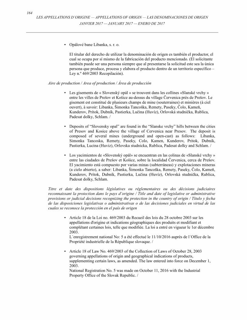
164 LES APPELLATIONS D’ORIGINE — APPELLATIONS OF ORIGIN — LAS DENOMINACIONES DE ORIGEN
JANVIER 2017 — JANUARY 2017 — ENERO DE 2017
▪ Opálové bane Libanka, s. r. o.
El titular del derecho de utilizar la denominación de origen es también el productor, el cual se ocupa por sí mismo de la fabricación del producto mencionado. (El solicitante también puede ser una persona siempre que al presentarse la solicitud este sea la única persona que produce, procesa y elabora el producto dentro de un territorio específico – Ley n.º 469/2003 Recopilación).
Aire de production / Area of production / Área de producción
▪ Les gisements de « Slovenský opál » se trouvent dans les collines «Slanské vrchy »
entre les villes de Prešov et Košice au-dessus du village Červenica près de Prešov. Le gisement est constitué de plusieurs champs de mine (souterraines) et minières (à ciel ouvert), à savoir: Libanka, Šimonka Tancoška, Remety, Paseky, Čolo, Kameň, Kunderov, Prítok, Dubník, Pastierka, Lučina (Huvíz), Orlovská studnička, Rublica, Padesat dolky, Schlam. /
▪ Deposits of “Slovensky opal” are found in the “Slanske vrchy” hills between the cities
of Presov and Kosice above the village of Cervenica near Presov. The deposit is composed of several mines (underground and open-cast) as follows: Libanka, Simonka Tancoska, Remety, Paseky, Colo, Kamen, Kunderov, Pritok, Dubnik, Pastierka, Lucina (Huviz), Orlovska studnicka, Rublica, Padesat dolky and Schlam. /
▪ Los yacimientos de «Slovenský opál» se encuentran en las colinas de «Slanské vrchy »
entre las ciudades de Prešov et Košice, sobre la localidad Červenica, cerca de Prešov. El yacimiento está compuesto por varias minas (subterráneas) y explotaciones mineras (a cielo abierto), a saber: Libanka, Šimonka Tancoška, Remety, Paseky, Čolo, Kameň, Kunderov, Prítok, Dubník, Pastierka, Lučina (Huvíz), Orlovská studnička, Rublica, Padesat dolky, Schlam.
Titre et date des dispositions législatives ou réglementaires ou des décisions judiciaires reconnaissant la protection dans le pays d’origine / Title and date of legislative or administrative provisions or judicial decisions recognizing the protection in the country of origin / Título y fecha de las disposiciones legislativas o administrativas o de las decisiones judiciales en virtud de las cuales se reconoce la protección en el país de origen
▪ Article 18 de la Loi no. 469/2003 du Recueil des lois du 28 octobre 2003 sur les appellations d'origine et indications géographiques des produits et modifiant et complétant certaines lois, telle que modifiée. La loi a entré en vigueur le 1er décembre 2003.
L´enregistrement national No: 5 a été effectué le 11/10/2016 auprès de l´Office de la Propriété industrielle de la République slovaque. /
▪ Article 18 of Law No. 469/2003 of the Collection of Laws of October 28, 2003
governing appellations of origin and geographical indications of products, supplementing certain laws, as amended. The law entered into force on December 1, 2003.
National Registration No. 5 was made on October 11, 2016 with the Industrial Property Office of the Slovak Republic. /
165
LES APPELLATIONS D’ORIGINE — APPELLATIONS OF ORIGIN — LAS DENOMINACIONES DE ORIGEN
JANVIER 2017 — JANUARY 2017 — ENERO DE 2017
▪ Artículo 18 de la Ley n.º 469/2003 de la Recopilación de leyes del 28 de octubre de 2003 sobre las denominaciones de origen e indicaciones geográficas de productos, que modifica y completa algunas leyes en su forma enmendada. La ley entró en vigor el 1 de diciembre de 2003.
El registro nacional n.º 5 fue efectuado el 28/02/2012 ante la Oficina de la Propiedad Industrial de la República Eslovaca.
Langue dans laquelle le Bureau international a reçu la demande internationale / Language in which the International Bureau received the international application / Idioma en el que la Oficina Internacional recibió la solicitud internacional
Anglais / English / Inglés

166 LES APPELLATIONS D’ORIGINE — APPELLATIONS OF ORIGIN — LAS DENOMINACIONES DE ORIGEN
JANVIER 2017 — JANUARY 2017 — ENERO DE 2017
167
LES APPELLATIONS D’ORIGINE — APPELLATIONS OF ORIGIN — LAS DENOMINACIONES DE ORIGEN
JANVIER 2017 — JANUARY 2017 — ENERO DE 2017
DÉCLARATIONS DE REFUS TOTAL OU PARTIEL / DECLARATIONS OF TOTAL OR PARTIAL REFUSAL /
DECLARACIONES DE DENEGACIÓN TOTAL O PARCIAL
Concernant l’enregistrement / Concerning Registration / Con respecto al Registro:
Nos. 960, 961, 964, 965, 969, 970, 981, 982, 986, 987, 989, 993, 994, 995, 996, 998, 1003, 1004, 1005, 1006, 1007, 1008, 1009, 1010,
1013, 1014, 1016, 1017, 1018, 1023, 1039, 1041, 1045, 1047, 1052, 1054, 1055, 1059, 1060
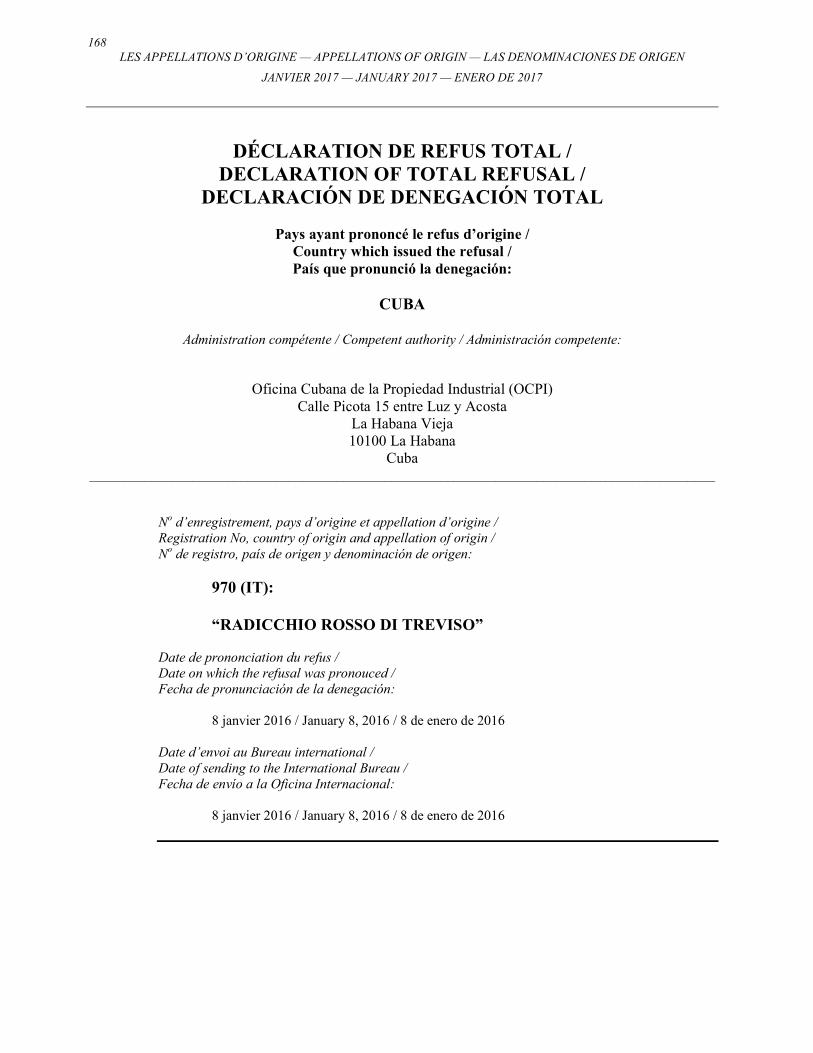
168 LES APPELLATIONS D’ORIGINE — APPELLATIONS OF ORIGIN — LAS DENOMINACIONES DE ORIGEN
JANVIER 2017 — JANUARY 2017 — ENERO DE 2017
DÉCLARATION DE REFUS TOTAL / DECLARATION OF TOTAL REFUSAL /
DECLARACIÓN DE DENEGACIÓN TOTAL
Pays ayant prononcé le refus d’origine / Country which issued the refusal / País que pronunció la denegación:
CUBA
Administration compétente / Competent authority / Administración competente:
Oficina Cubana de la Propiedad Industrial (OCPI) Calle Picota 15 entre Luz y Acosta
La Habana Vieja 10100 La Habana
Cuba ___________________________________________________________________________________________
No d’enregistrement, pays d’origine et appellation d’origine / Registration No, country of origin and appellation of origin / No de registro, país de origen y denominación de origen:
970 (IT): “RADICCHIO ROSSO DI TREVISO”
Date de prononciation du refus / Date on which the refusal was pronouced / Fecha de pronunciación de la denegación: 8 janvier 2016 / January 8, 2016 / 8 de enero de 2016 Date d’envoi au Bureau international / Date of sending to the International Bureau / Fecha de envío a la Oficina Internacional: 8 janvier 2016 / January 8, 2016 / 8 de enero de 2016
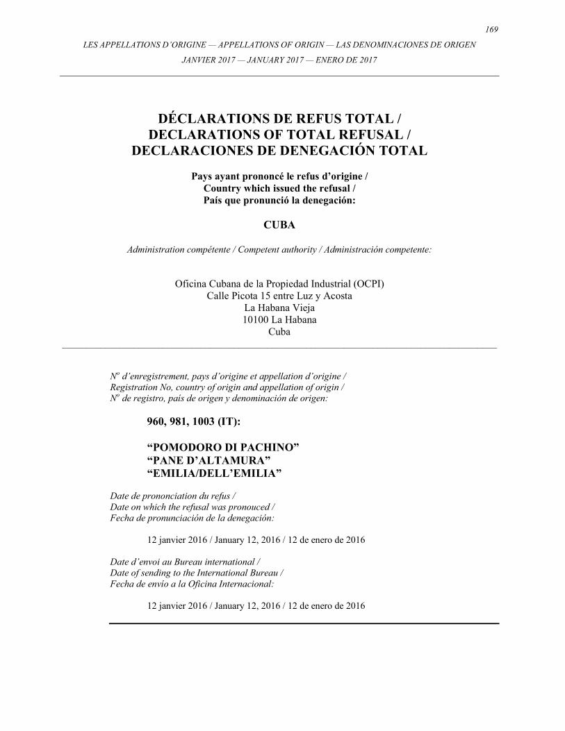
169
LES APPELLATIONS D’ORIGINE — APPELLATIONS OF ORIGIN — LAS DENOMINACIONES DE ORIGEN
JANVIER 2017 — JANUARY 2017 — ENERO DE 2017
DÉCLARATIONS DE REFUS TOTAL / DECLARATIONS OF TOTAL REFUSAL /
DECLARACIONES DE DENEGACIÓN TOTAL
Pays ayant prononcé le refus d’origine / Country which issued the refusal / País que pronunció la denegación:
CUBA
Administration compétente / Competent authority / Administración competente:
Oficina Cubana de la Propiedad Industrial (OCPI) Calle Picota 15 entre Luz y Acosta
La Habana Vieja 10100 La Habana
Cuba ___________________________________________________________________________________________
No d’enregistrement, pays d’origine et appellation d’origine / Registration No, country of origin and appellation of origin / No de registro, país de origen y denominación de origen:
960, 981, 1003 (IT): “POMODORO DI PACHINO” “PANE D’ALTAMURA” “EMILIA/DELL’EMILIA”
Date de prononciation du refus / Date on which the refusal was pronouced / Fecha de pronunciación de la denegación: 12 janvier 2016 / January 12, 2016 / 12 de enero de 2016 Date d’envoi au Bureau international / Date of sending to the International Bureau / Fecha de envío a la Oficina Internacional: 12 janvier 2016 / January 12, 2016 / 12 de enero de 2016
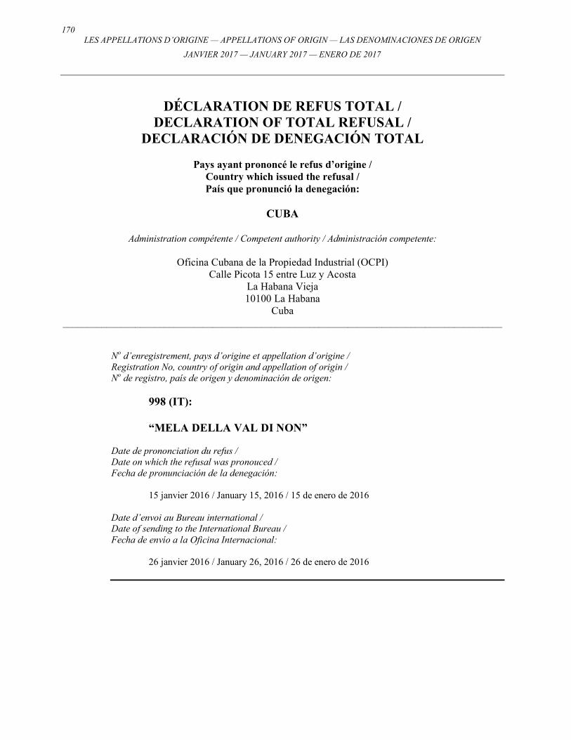
170 LES APPELLATIONS D’ORIGINE — APPELLATIONS OF ORIGIN — LAS DENOMINACIONES DE ORIGEN
JANVIER 2017 — JANUARY 2017 — ENERO DE 2017
DÉCLARATION DE REFUS TOTAL / DECLARATION OF TOTAL REFUSAL /
DECLARACIÓN DE DENEGACIÓN TOTAL
Pays ayant prononcé le refus d’origine / Country which issued the refusal / País que pronunció la denegación:
CUBA
Administration compétente / Competent authority / Administración competente:
Oficina Cubana de la Propiedad Industrial (OCPI)
Calle Picota 15 entre Luz y Acosta La Habana Vieja 10100 La Habana
Cuba ___________________________________________________________________________________________
No d’enregistrement, pays d’origine et appellation d’origine / Registration No, country of origin and appellation of origin / No de registro, país de origen y denominación de origen:
998 (IT): “MELA DELLA VAL DI NON”
Date de prononciation du refus / Date on which the refusal was pronouced / Fecha de pronunciación de la denegación: 15 janvier 2016 / January 15, 2016 / 15 de enero de 2016 Date d’envoi au Bureau international / Date of sending to the International Bureau / Fecha de envío a la Oficina Internacional: 26 janvier 2016 / January 26, 2016 / 26 de enero de 2016
171
LES APPELLATIONS D’ORIGINE — APPELLATIONS OF ORIGIN — LAS DENOMINACIONES DE ORIGEN
JANVIER 2017 — JANUARY 2017 — ENERO DE 2017
DÉCLARATIONS DE REFUS TOTAL / DECLARATIONS OF TOTAL REFUSAL /
DECLARACIONES DE DENEGACIÓN TOTAL
Pays ayant prononcé le refus d’origine / Country which issued the refusal / País que pronunció la denegación:
PERU / PERU / PERÚ
Administration compétente / Competent authority / Administración competente:
Instituto Nacional para la Defensa de laCompetencia y de la Protección de laPropiedad Intelectual (INDECOPI)
Calle de la Prosa 138 San Borja Lima 41
Perú ___________________________________________________________________________________________
No d’enregistrement, pays d’origine et appellation d’origine / Registration No, country of origin and appellation of origin / No de registro, país de origen y denominación de origen:
961, 964 (IT): “ACETO BALSAMICO TRADIZIONALE DI MODENA” “GRAPPA”
Date de prononciation du refus / Date on which the refusal was pronouced / Fecha de pronunciación de la denegación: 3 février 2016 / February 3, 2016 / 3 de febrero de 2016 Date d’envoi au Bureau international / Date of sending to the International Bureau / Fecha de envío a la Oficina Internacional: 8 février 2016 / February 8, 2016 / 8 de febrero de 2016
172 LES APPELLATIONS D’ORIGINE — APPELLATIONS OF ORIGIN — LAS DENOMINACIONES DE ORIGEN
JANVIER 2017 — JANUARY 2017 — ENERO DE 2017
DÉCLARATION DE REFUS TOTAL / DECLARATION OF TOTAL REFUSAL /
DECLARACIÓN DE DENEGACIÓN TOTAL
Pays ayant prononcé le refus d’origine / Country which issued the refusal / País que pronunció la denegación:
ISRAËL / ISRAEL / ISRAEL
Administration compétente / Competent authority / Administración competente:
The Israeli Patent Office Agudat Sport Hapoel Street
Technological Garden, Building 5 96951 Jerusalem
___________________________________________________________________________________________ No d’enregistrement, pays d’origine et appellation d’origine / Registration No, country of origin and appellation of origin / No de registro, país de origen y denominación de origen:
1010 (CU): “CUBA”
Date de prononciation du refus / Date on which the refusal was pronouced / Fecha de pronunciación de la denegación: 16 février 2016 / February 16, 2016 / 16 de febrero de 2016 Date d’envoi au Bureau international / Date of sending to the International Bureau / Fecha de envío a la Oficina Internacional: 16 février 2016 / February 16, 2016 / 16 de febrero de 2016
173
LES APPELLATIONS D’ORIGINE — APPELLATIONS OF ORIGIN — LAS DENOMINACIONES DE ORIGEN
JANVIER 2017 — JANUARY 2017 — ENERO DE 2017
DÉCLARATION DE REFUS TOTAL / DECLARATION OF TOTAL REFUSAL /
DECLARACIÓN DE DENEGACIÓN TOTAL
Pays ayant prononcé le refus d’origine / Country which issued the refusal / País que pronunció la denegación:
RÉPUBLIQUE DE MOLDOVA /
REPUBLIC OF MOLDOVA / REPÚBLICA DE MOLDOVA
Administration compétente / Competent authority / Administración competente:
Agence nationale de la propriété intellectuelle (AGEPI) 24/1 Andrei Doga Str.
Chisinau, MD2024 République de Moldova
___________________________________________________________________________________________ No d’enregistrement, pays d’origine et appellation d’origine / Registration No, country of origin and appellation of origin / No de registro, país de origen y denominación de origen:
1003 (IT): “EMILIA/DELL’EMILIA”
Date de prononciation du refus / Date on which the refusal was pronouced / Fecha de pronunciación de la denegación: 11 février 2016 / February11, 2016 / 11 de febrero de 2016 Date d’envoi au Bureau international / Date of sending to the International Bureau / Fecha de envío a la Oficina Internacional: 12 mars 2016 / March 12, 2016 / 12 de marzo de 2016
174 LES APPELLATIONS D’ORIGINE — APPELLATIONS OF ORIGIN — LAS DENOMINACIONES DE ORIGEN
JANVIER 2017 — JANUARY 2017 — ENERO DE 2017
DÉCLARATIONS DE REFUS PARTIEL /
DECLARATIONS OF PARTIAL REFUSAL / DECLARACIONES DE DENEGACIÓN PARCIAL
Pays ayant prononcé le refus d’origine /
Country which issued the refusal / País que pronunció la denegación:
MEXIQUE / MEXICO / MÉXICO
Administration compétente / Competent authority / Administración competente:
Instituto Mexicano de la Propiedad Industrial (IMPI) Periférico Sur N.° 3106
Col. Jardines del Pedregal 01900 México D.F.
México ___________________________________________________________________________________________
No d’enregistrement, pays d’origine et appellation d’origine / Registration No, country of origin and appellation of origin / No de registro, país de origen y denominación de origen:
961, 965, 993, 994, 995, 996 (IT): “ACETO BALSAMICO TRADIZIONALE DI MODENA” “BRESAOLA DELLA VALTELLINA” “SALSICCIA DI CALABRIA” “SOPPRESSATA DI CALABRIA” “CAPOCOLLO DI CALABRIA” “PANCETTA DI CALABRIA”
Date de prononciation du refus / Date on which the refusal was pronouced / Fecha de pronunciación de la denegación: 11 mars 2016 / March 11, 2016 / 11 de marzo de 2016 Date d’envoi au Bureau international / Date of sending to the International Bureau / Fecha de envío a la Oficina Internacional: 18 mars 2016 / March 18, 2016 / 18 de marzo de 2016
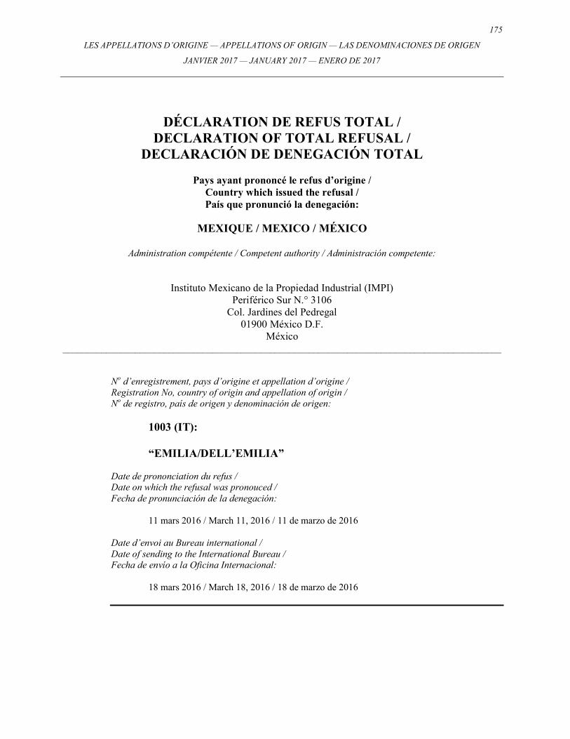
175
LES APPELLATIONS D’ORIGINE — APPELLATIONS OF ORIGIN — LAS DENOMINACIONES DE ORIGEN
JANVIER 2017 — JANUARY 2017 — ENERO DE 2017
DÉCLARATION DE REFUS TOTAL / DECLARATION OF TOTAL REFUSAL /
DECLARACIÓN DE DENEGACIÓN TOTAL
Pays ayant prononcé le refus d’origine / Country which issued the refusal / País que pronunció la denegación:
MEXIQUE / MEXICO / MÉXICO
Administration compétente / Competent authority / Administración competente:
Instituto Mexicano de la Propiedad Industrial (IMPI) Periférico Sur N.° 3106
Col. Jardines del Pedregal 01900 México D.F.
México ___________________________________________________________________________________________
No d’enregistrement, pays d’origine et appellation d’origine / Registration No, country of origin and appellation of origin / No de registro, país de origen y denominación de origen:
1003 (IT): “EMILIA/DELL’EMILIA”
Date de prononciation du refus / Date on which the refusal was pronouced / Fecha de pronunciación de la denegación: 11 mars 2016 / March 11, 2016 / 11 de marzo de 2016 Date d’envoi au Bureau international / Date of sending to the International Bureau / Fecha de envío a la Oficina Internacional: 18 mars 2016 / March 18, 2016 / 18 de marzo de 2016
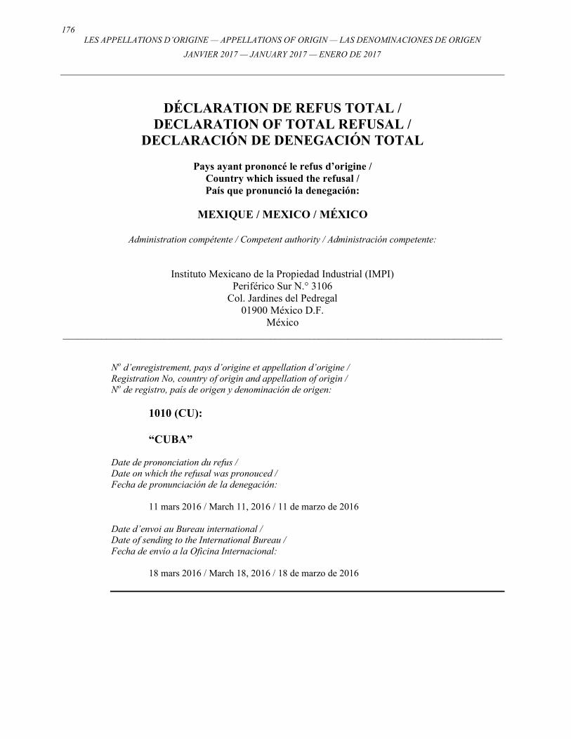
176 LES APPELLATIONS D’ORIGINE — APPELLATIONS OF ORIGIN — LAS DENOMINACIONES DE ORIGEN
JANVIER 2017 — JANUARY 2017 — ENERO DE 2017
DÉCLARATION DE REFUS TOTAL / DECLARATION OF TOTAL REFUSAL /
DECLARACIÓN DE DENEGACIÓN TOTAL
Pays ayant prononcé le refus d’origine / Country which issued the refusal / País que pronunció la denegación:
MEXIQUE / MEXICO / MÉXICO
Administration compétente / Competent authority / Administración competente:
Instituto Mexicano de la Propiedad Industrial (IMPI) Periférico Sur N.° 3106
Col. Jardines del Pedregal 01900 México D.F.
México ___________________________________________________________________________________________
No d’enregistrement, pays d’origine et appellation d’origine / Registration No, country of origin and appellation of origin / No de registro, país de origen y denominación de origen:
1010 (CU): “CUBA”
Date de prononciation du refus / Date on which the refusal was pronouced / Fecha de pronunciación de la denegación: 11 mars 2016 / March 11, 2016 / 11 de marzo de 2016 Date d’envoi au Bureau international / Date of sending to the International Bureau / Fecha de envío a la Oficina Internacional: 18 mars 2016 / March 18, 2016 / 18 de marzo de 2016
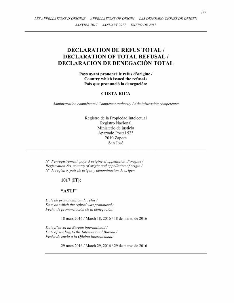
177
LES APPELLATIONS D’ORIGINE — APPELLATIONS OF ORIGIN — LAS DENOMINACIONES DE ORIGEN
JANVIER 2017 — JANUARY 2017 — ENERO DE 2017
DÉCLARATION DE REFUS TOTAL / DECLARATION OF TOTAL REFUSAL /
DECLARACIÓN DE DENEGACIÓN TOTAL
Pays ayant prononcé le refus d’origine / Country which issued the refusal / País que pronunció la denegación:
COSTA RICA
Administration compétente / Competent authority / Administración competente:
Registro de la Propiedad Intelectual Registro Nacional
Ministerio de justicia Apartado Postal 523
2010 Zapote San José
___________________________________________________________________________________________ No d’enregistrement, pays d’origine et appellation d’origine / Registration No, country of origin and appellation of origin / No de registro, país de origen y denominación de origen:
1017 (IT): “ASTI”
Date de prononciation du refus / Date on which the refusal was pronouced / Fecha de pronunciación de la denegación: 18 mars 2016 / March 18, 2016 / 18 de marzo de 2016 Date d’envoi au Bureau international / Date of sending to the International Bureau / Fecha de envío a la Oficina Internacional: 29 mars 2016 / March 29, 2016 / 29 de marzo de 2016
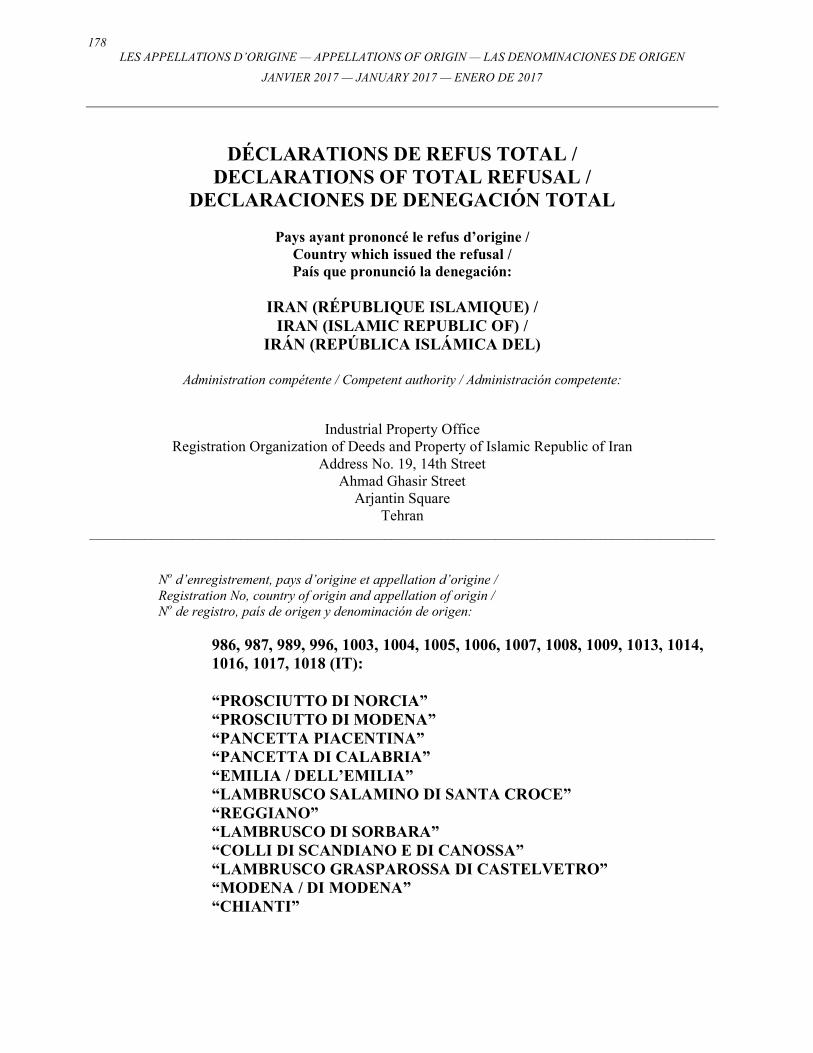
178 LES APPELLATIONS D’ORIGINE — APPELLATIONS OF ORIGIN — LAS DENOMINACIONES DE ORIGEN
JANVIER 2017 — JANUARY 2017 — ENERO DE 2017
DÉCLARATIONS DE REFUS TOTAL / DECLARATIONS OF TOTAL REFUSAL /
DECLARACIONES DE DENEGACIÓN TOTAL
Pays ayant prononcé le refus d’origine / Country which issued the refusal / País que pronunció la denegación:
IRAN (RÉPUBLIQUE ISLAMIQUE) /
IRAN (ISLAMIC REPUBLIC OF) / IRÁN (REPÚBLICA ISLÁMICA DEL)
Administration compétente / Competent authority / Administración competente:
Industrial Property Office Registration Organization of Deeds and Property of Islamic Republic of Iran
Address No. 19, 14th Street Ahmad Ghasir Street
Arjantin Square Tehran
___________________________________________________________________________________________ No d’enregistrement, pays d’origine et appellation d’origine / Registration No, country of origin and appellation of origin / No de registro, país de origen y denominación de origen:
986, 987, 989, 996, 1003, 1004, 1005, 1006, 1007, 1008, 1009, 1013, 1014, 1016, 1017, 1018 (IT): “PROSCIUTTO DI NORCIA” “PROSCIUTTO DI MODENA” “PANCETTA PIACENTINA” “PANCETTA DI CALABRIA” “EMILIA / DELL’EMILIA” “LAMBRUSCO SALAMINO DI SANTA CROCE” “REGGIANO” “LAMBRUSCO DI SORBARA” “COLLI DI SCANDIANO E DI CANOSSA” “LAMBRUSCO GRASPAROSSA DI CASTELVETRO” “MODENA / DI MODENA” “CHIANTI”
179
LES APPELLATIONS D’ORIGINE — APPELLATIONS OF ORIGIN — LAS DENOMINACIONES DE ORIGEN
JANVIER 2017 — JANUARY 2017 — ENERO DE 2017
“SICILIA” “BONARDA DELL’OLTREPO PAVESE” “ASTI” “COPPA DI PARMA”
Date de prononciation du refus / Date on which the refusal was pronouced / Fecha de pronunciación de la denegación: 29 mars 2016 / March 29, 2016 / 29 de marzo de 2016 Date d’envoi au Bureau international / Date of sending to the International Bureau / Fecha de envío a la Oficina Internacional: 30 mars 2016 / March 30, 2016 / 30 de marzo de 2016
180 LES APPELLATIONS D’ORIGINE — APPELLATIONS OF ORIGIN — LAS DENOMINACIONES DE ORIGEN
JANVIER 2017 — JANUARY 2017 — ENERO DE 2017
DÉCLARATION DE REFUS TOTAL / DECLARATION OF TOTAL REFUSAL /
DECLARACIÓN DE DENEGACIÓN TOTAL
Pays ayant prononcé le refus d’origine / Country which issued the refusal / País que pronunció la denegación:
IRAN (RÉPUBLIQUE ISLAMIQUE) /
IRAN (ISLAMIC REPUBLIC OF) / IRÁN (REPÚBLICA ISLÁMICA DEL)
Administration compétente / Competent authority / Administración competente:
Industrial Property Office Registration Organization of Deeds and Property of Islamic Republic of Iran
Address No. 19, 14th Street Ahmad Ghasir Street
Arjantin Square Tehran
___________________________________________________________________________________________ No d’enregistrement, pays d’origine et appellation d’origine / Registration No, country of origin and appellation of origin / No de registro, país de origen y denominación de origen:
1010 (CU): “CUBA”
Date de prononciation du refus / Date on which the refusal was pronouced / Fecha de pronunciación de la denegación: 29 mars 2016 / March 29, 2016 / 29 de marzo de 2016 Date d’envoi au Bureau international / Date of sending to the International Bureau / Fecha de envío a la Oficina Internacional: 30 mars 2016 / March 30, 2016 / 30 de marzo de 2016
181
LES APPELLATIONS D’ORIGINE — APPELLATIONS OF ORIGIN — LAS DENOMINACIONES DE ORIGEN
JANVIER 2017 — JANUARY 2017 — ENERO DE 2017
DÉCLARATIONS DE REFUS PARTIEL / DECLARATIONS OF PARTIAL REFUSAL /
DECLARACIONES DE DENEGACIÓN PARCIAL
Pays ayant prononcé le refus d’origine / Country which issued the refusal / País que pronunció la denegación:
PERU / PERU / PERÚ
Administration compétente / Competent authority / Administración competente:
Instituto Nacional para la Defensa de laCompetencia y de la Protección de laPropiedad Intelectual (INDECOPI)
Calle de la Prosa 138 San Borja Lima 41
Perú ___________________________________________________________________________________________
No d’enregistrement, pays d’origine et appellation d’origine / Registration No, country of origin and appellation of origin / No de registro, país de origen y denominación de origen:
969, 982 (IT): “LIMONE DI SORRENTO” “TERRE DI SIENA”
Date de prononciation du refus / Date on which the refusal was pronouced / Fecha de pronunciación de la denegación: 31 mars 2016 / March 31, 2016 / 31 de marzo de 2016 Date d’envoi au Bureau international / Date of sending to the International Bureau / Fecha de envío a la Oficina Internacional: 31 mars 2016 / March 31, 2016 / 31 de marzo de 2016
182 LES APPELLATIONS D’ORIGINE — APPELLATIONS OF ORIGIN — LAS DENOMINACIONES DE ORIGEN
JANVIER 2017 — JANUARY 2017 — ENERO DE 2017
DÉCLARATIONS DE REFUS TOTAL / DECLARATIONS OF TOTAL REFUSAL /
DECLARACIONES DE DENEGACIÓN TOTAL
Pays ayant prononcé le refus d’origine / Country which issued the refusal / País que pronunció la denegación:
IRAN (RÉPUBLIQUE ISLAMIQUE) /
IRAN (ISLAMIC REPUBLIC OF) / IRÁN (REPÚBLICA ISLÁMICA DEL)
Administration compétente / Competent authority / Administración competente:
Industrial Property Office Registration Organization of Deeds and Property of Islamic Republic of Iran
Address No. 19, 14th Street Ahmad Ghasir Street
Arjantin Square Tehran
___________________________________________________________________________________________ No d’enregistrement, pays d’origine et appellation d’origine / Registration No, country of origin and appellation of origin / No de registro, país de origen y denominación de origen:
993, 994, 995 (IT): “SALSICCIA DI CALABRIA” “SOPPRESSATA DI CALABRIA” “CAPOCOLLO DI CALABRIA”
Date de prononciation du refus / Date on which the refusal was pronouced / Fecha de pronunciación de la denegación: 29 mars 2016 / March 29, 2016 / 29 de marzo de 2016 Date d’envoi au Bureau international / Date of sending to the International Bureau / Fecha de envío a la Oficina Internacional: 2 avril 2016 / April 2, 2016 / 2 de abril de 2016
183
LES APPELLATIONS D’ORIGINE — APPELLATIONS OF ORIGIN — LAS DENOMINACIONES DE ORIGEN
JANVIER 2017 — JANUARY 2017 — ENERO DE 2017
DÉCLARATION DE REFUS TOTAL / DECLARATION OF TOTAL REFUSAL /
DECLARACIÓN DE DENEGACIÓN TOTAL
Pays ayant prononcé le refus d’origine / Country which issued the refusal / País que pronunció la denegación:
COSTA RICA
Administration compétente / Competent authority / Administración competente:
Registro de la Propiedad Intelectual Registro Nacional
Ministerio de justicia Apartado Postal 523
2010 Zapote San José
___________________________________________________________________________________________ No d’enregistrement, pays d’origine et appellation d’origine / Registration No, country of origin and appellation of origin / No de registro, país de origen y denominación de origen:
1023 (IR): “FARSH E DASTBAFT E SONGHOR O KOLEYAYE E KERMANSHAH”
Date de prononciation du refus / Date on which the refusal was pronouced / Fecha de pronunciación de la denegación: 6 avril 2016 / April 6, 2016 / 6 de abril de 2016 Date d’envoi au Bureau international / Date of sending to the International Bureau / Fecha de envío a la Oficina Internacional: 8 avril 2016 / April 8, 2016 / 8 de abril de 2016
184 LES APPELLATIONS D’ORIGINE — APPELLATIONS OF ORIGIN — LAS DENOMINACIONES DE ORIGEN
JANVIER 2017 — JANUARY 2017 — ENERO DE 2017
DÉCLARATIONS DE REFUS TOTAL / DECLARATIONS OF TOTAL REFUSAL /
DECLARACIONES DE DENEGACIÓN TOTAL
Pays ayant prononcé le refus d’origine / Country which issued the refusal / País que pronunció la denegación:
PERU / PERU / PERÚ
Administration compétente / Competent authority / Administración competente:
Instituto Nacional para la Defensa de la Competencia y de la Protección de la Propiedad Intelectual (INDECOPI)
Calle de la Prosa 138 San Borja Lima 41
Perú ___________________________________________________________________________________________
No d’enregistrement, pays d’origine et appellation d’origine / Registration No, country of origin and appellation of origin / No de registro, país de origen y denominación de origen:
1006, 1008 (IT): “LAMBRUSCO DI SORBARA” “LAMBRUSCO GRASPAROSSA DI CASTELVETRO”
Date de prononciation du refus / Date on which the refusal was pronouced / Fecha de pronunciación de la denegación: 12 août 2016 / August 12, 2016 / 12 de augusto de 2016 Date d’envoi au Bureau international / Date of sending to the International Bureau / Fecha de envío a la Oficina Internacional: 16 août 2016 / August 16, 2016 / 16 de augusto de 2016
185
LES APPELLATIONS D’ORIGINE — APPELLATIONS OF ORIGIN — LAS DENOMINACIONES DE ORIGEN
JANVIER 2017 — JANUARY 2017 — ENERO DE 2017
DÉCLARATION DE REFUS TOTAL / DECLARATION OF TOTAL REFUSAL /
DECLARACIÓN DE DENEGACIÓN TOTAL
Pays ayant prononcé le refus d’origine / Country which issued the refusal / País que pronunció la denegación:
PERU / PERU / PERÚ
Administration compétente / Competent authority / Administración competente:
Instituto Nacional para la Defensa de la Competencia y de la Protección de la Propiedad Intelectual (INDECOPI)
Calle de la Prosa 138 San Borja Lima 41
Perú ___________________________________________________________________________________________
No d’enregistrement, pays d’origine et appellation d’origine / Registration No, country of origin and appellation of origin / No de registro, país de origen y denominación de origen:
1003 (IT): “EMILIA / DELL’EMILIA”
Date de prononciation du refus / Date on which the refusal was pronouced / Fecha de pronunciación de la denegación: 18 août 2016 / August 18, 2016 / 18 de augusto de 2016 Date d’envoi au Bureau international / Date of sending to the International Bureau / Fecha de envío a la Oficina Internacional: 19 août 2016 / August 19, 2016 / 19 de augusto de 2016
186 LES APPELLATIONS D’ORIGINE — APPELLATIONS OF ORIGIN — LAS DENOMINACIONES DE ORIGEN
JANVIER 2017 — JANUARY 2017 — ENERO DE 2017
DÉCLARATIONS DE REFUS TOTAL / DECLARATIONS OF TOTAL REFUSAL /
DECLARACIONES DE DENEGACIÓN TOTAL
Pays ayant prononcé le refus d’origine / Country which issued the refusal / País que pronunció la denegación:
COSTA RICA
Administration compétente / Competent authority / Administración competente:
Registro de la Propiedad Intelectual Registro Nacional
Ministerio de justicia Apartado Postal 523
2010 Zapote San José
___________________________________________________________________________________________ No d’enregistrement, pays d’origine et appellation d’origine / Registration No, country of origin and appellation of origin / No de registro, país de origen y denominación de origen:
1041, 1045, 1047, 1054, 1059 (IT): “MONTEPULCIANO D’ABRUZZO” “BARBERA D’ASTI” “CONEGLIANO VALDOBBIADENE - PROSECCO / CONEGLIANO
- PROSECCO / VALDOBBIADENE - PROSECCO” “ARANCIA DI RIBERA” “CHIANTI CLASSICO”
Date de prononciation du refus / Date on which the refusal was pronouced / Fecha de pronunciación de la denegación: 22 août 2016 / August 22, 2016 / 22 de augusto de 2016 Date d’envoi au Bureau international / Date of sending to the International Bureau / Fecha de envío a la Oficina Internacional: 7 novembre 2016 / November 7, 2016 / 7 de noviembre de 2016
187
LES APPELLATIONS D’ORIGINE — APPELLATIONS OF ORIGIN — LAS DENOMINACIONES DE ORIGEN
JANVIER 2017 — JANUARY 2017 — ENERO DE 2017
DÉCLARATION DE REFUS TOTAL / DECLARATION OF TOTAL REFUSAL /
DECLARACIÓN DE DENEGACIÓN TOTAL
Pays ayant prononcé le refus d’origine / Country which issued the refusal / País que pronunció la denegación:
COSTA RICA
Administration compétente / Competent authority / Administración competente:
Registro de la Propiedad Intelectual Registro Nacional
Ministerio de justicia Apartado Postal 523
2010 Zapote San José
___________________________________________________________________________________________ No d’enregistrement, pays d’origine et appellation d’origine / Registration No, country of origin and appellation of origin / No de registro, país de origen y denominación de origen:
1014 (IT): “SICILIA”
Date de prononciation du refus / Date on which the refusal was pronouced / Fecha de pronunciación de la denegación: 5 août 2016 / August 5, 2016 / 5 de augusto de 2016 Date d’envoi au Bureau international / Date of sending to the International Bureau / Fecha de envío a la Oficina Internacional: 16 novembre 2016 / November 16, 2016 / 16 de noviembre de 2016
188 LES APPELLATIONS D’ORIGINE — APPELLATIONS OF ORIGIN — LAS DENOMINACIONES DE ORIGEN
JANVIER 2017 — JANUARY 2017 — ENERO DE 2017
DÉCLARATIONS DE REFUS TOTAL / DECLARATIONS OF TOTAL REFUSAL /
DECLARACIONES DE DENEGACIÓN TOTAL
Pays ayant prononcé le refus d’origine / Country which issued the refusal / País que pronunció la denegación:
ISRAËL / ISRAEL / ISRAEL
Administration compétente / Competent authority / Administración competente:
The Israeli Patent Office Agudat Sport Hapoel Street
Technological Garden, Building 5 96951 Jerusalem
___________________________________________________________________________________________ No d’enregistrement, pays d’origine et appellation d’origine / Registration No, country of origin and appellation of origin / No de registro, país de origen y denominación de origen:
1039, 1052, 1060 (IT): “MELANNURCA CAMPANA” “LIMONE DI SIRACUSA” “ALTO ADIGE / DELL'ALTO ADIGE (SÜDTIROL SÜDTIROLER)”
Date de prononciation du refus / Date on which the refusal was pronouced / Fecha de pronunciación de la denegación: 11 décembre 2016 / December 11, 2016 / 11 de diciembre de 2016 Date d’envoi au Bureau international / Date of sending to the International Bureau / Fecha de envío a la Oficina Internacional: 11 décembre 2016 / December 11, 2016 / 11 de diciembre de 2016
189
LES APPELLATIONS D’ORIGINE — APPELLATIONS OF ORIGIN — LAS DENOMINACIONES DE ORIGEN
JANVIER 2017 — JANUARY 2017 — ENERO DE 2017
DÉCLARATION DE REFUS TOTAL / DECLARATION OF TOTAL REFUSAL /
DECLARACIÓN DE DENEGACIÓN TOTAL
Pays ayant prononcé le refus d’origine / Country which issued the refusal / País que pronunció la denegación:
CUBA
Administration compétente / Competent authority / Administración competente:
Oficina Cubana de la Propiedad Industrial (OCPI)
Calle Picota 15 entre Luz y Acosta La Habana Vieja 10100 La Habana
Cuba ___________________________________________________________________________________________
No d’enregistrement, pays d’origine et appellation d’origine / Registration No, country of origin and appellation of origin / No de registro, país de origen y denominación de origen:
1055 (IT): “NOCCIOLA DI GIFFONI”
Date de prononciation du refus / Date on which the refusal was pronouced / Fecha de pronunciación de la denegación: 14 décembre 2016 / December 14, 2016 / 14 de diciembre de 2016 Date d’envoi au Bureau international / Date of sending to the International Bureau / Fecha de envío a la Oficina Internacional: 14 décembre 2016 / December 14, 2016 / 14 de diciembre de 2016

190 LES APPELLATIONS D’ORIGINE — APPELLATIONS OF ORIGIN — LAS DENOMINACIONES DE ORIGEN
JANVIER 2017 — JANUARY 2017 — ENERO DE 2017
191
LES APPELLATIONS D’ORIGINE — APPELLATIONS OF ORIGIN — LAS DENOMINACIONES DE ORIGEN
JANVIER 2017 — JANUARY 2017 — ENERO DE 2017
RETRAITS TOTAUX OU PARTIELS D’UNE DÉCLARATION DE REFUS /
TOTAL OR PARTIAL WITHDRAWALS OF A DECLARATION OF REFUSAL /
RETIROS TOTALES O PARCIALES DE UNA DECLARACIÓN DE DENEGACIÓN
Concernant l’enregistrement / Concerning Registration / Con respecto al Registro:
No. 924, 931, 933, 988, 989, 992, 993, 1023
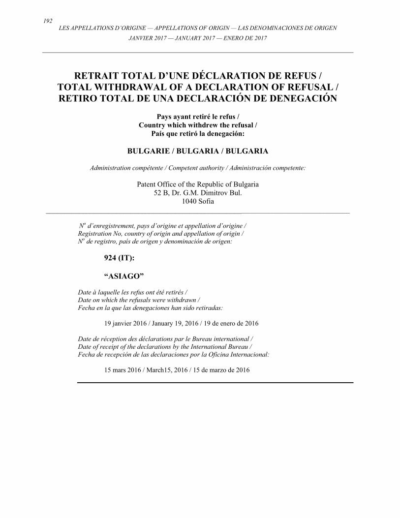
192 LES APPELLATIONS D’ORIGINE — APPELLATIONS OF ORIGIN — LAS DENOMINACIONES DE ORIGEN
JANVIER 2017 — JANUARY 2017 — ENERO DE 2017
RETRAIT TOTAL D’UNE DÉCLARATION DE REFUS / TOTAL WITHDRAWAL OF A DECLARATION OF REFUSAL / RETIRO TOTAL DE UNA DECLARACIÓN DE DENEGACIÓN
Pays ayant retiré le refus /
Country which withdrew the refusal / País que retiró la denegación:
BULGARIE / BULGARIA / BULGARIA
Administration compétente / Competent authority / Administración competente:
Patent Office of the Republic of Bulgaria
52 B, Dr. G.M. Dimitrov Bul. 1040 Sofia
_____________________________________________________________________________________
No d’enregistrement, pays d’origine et appellation d’origine / Registration No, country of origin and appellation of origin / No de registro, país de origen y denominación de origen:
924 (IT): “ASIAGO”
Date à laquelle les refus ont été retirés / Date on which the refusals were withdrawn / Fecha en la que las denegaciones han sido retiradas: 19 janvier 2016 / January 19, 2016 / 19 de enero de 2016 Date de réception des déclarations par le Bureau international / Date of receipt of the declarations by the International Bureau / Fecha de recepción de las declaraciones por la Oficina Internacional: 15 mars 2016 / March15, 2016 / 15 de marzo de 2016

193
LES APPELLATIONS D’ORIGINE — APPELLATIONS OF ORIGIN — LAS DENOMINACIONES DE ORIGEN
JANVIER 2017 — JANUARY 2017 — ENERO DE 2017
RETRAIT TOTAL D’UNE DÉCLARATION DE REFUS / TOTAL WITHDRAWAL OF A DECLARATION OF REFUSAL / RETIRO TOTAL DE UNA DECLARACIÓN DE DENEGACIÓN
Pays ayant retiré le refus /
Country which withdrew the refusal / País que retiró la denegación:
COSTA RICA
Administration compétente / Competent authority / Administración competente:
Registro de la Propiedad Intelectual
Registro Nacional Ministerio de justicia Apartado Postal 523
2010 Zapote San José
___________________________________________________________________________________________ No d’enregistrement, pays d’origine et appellation d’origine / Registration No, country of origin and appellation of origin / No de registro, país de origen y denominación de origen:
1023 (IR): “FARSH E DASTBAFT E SONGHOR O KOLEYAYE E KERMANSHAH”
Date à laquelle les refus ont été retirés / Date on which the refusals were withdrawn / Fecha en la que las denegaciones han sido retiradas: 25 avril 2016 / April 25, 2016 / 25 de abril de 2016 Date de réception des déclarations par le Bureau international / Date of receipt of the declarations by the International Bureau / Fecha de recepción de las declaraciones por la Oficina Internacional: 25 avril 2016 / April 25, 2016 / 25 de abril de 2016
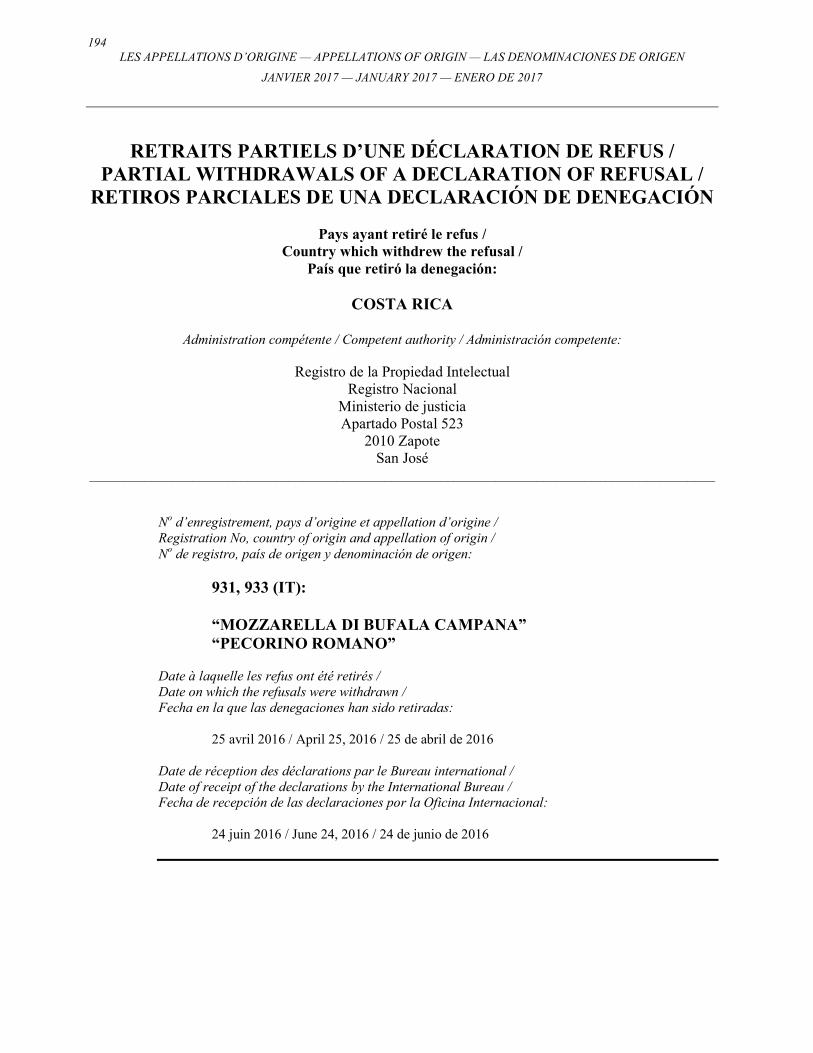
194 LES APPELLATIONS D’ORIGINE — APPELLATIONS OF ORIGIN — LAS DENOMINACIONES DE ORIGEN
JANVIER 2017 — JANUARY 2017 — ENERO DE 2017
RETRAITS PARTIELS D’UNE DÉCLARATION DE REFUS / PARTIAL WITHDRAWALS OF A DECLARATION OF REFUSAL /
RETIROS PARCIALES DE UNA DECLARACIÓN DE DENEGACIÓN
Pays ayant retiré le refus / Country which withdrew the refusal /
País que retiró la denegación:
COSTA RICA
Administration compétente / Competent authority / Administración competente:
Registro de la Propiedad Intelectual Registro Nacional
Ministerio de justicia Apartado Postal 523
2010 Zapote San José
___________________________________________________________________________________________ No d’enregistrement, pays d’origine et appellation d’origine / Registration No, country of origin and appellation of origin / No de registro, país de origen y denominación de origen:
931, 933 (IT): “MOZZARELLA DI BUFALA CAMPANA” “PECORINO ROMANO”
Date à laquelle les refus ont été retirés / Date on which the refusals were withdrawn / Fecha en la que las denegaciones han sido retiradas: 25 avril 2016 / April 25, 2016 / 25 de abril de 2016 Date de réception des déclarations par le Bureau international / Date of receipt of the declarations by the International Bureau / Fecha de recepción de las declaraciones por la Oficina Internacional: 24 juin 2016 / June 24, 2016 / 24 de junio de 2016
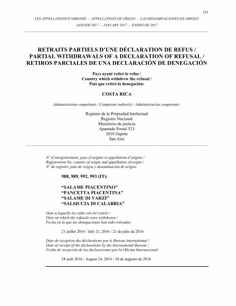
195
LES APPELLATIONS D’ORIGINE — APPELLATIONS OF ORIGIN — LAS DENOMINACIONES DE ORIGEN
JANVIER 2017 — JANUARY 2017 — ENERO DE 2017
RETRAITS PARTIELS D’UNE DÉCLARATION DE REFUS / PARTIAL WITHDRAWALS OF A DECLARATION OF REFUSAL /
RETIROS PARCIALES DE UNA DECLARACIÓN DE DENEGACIÓN
Pays ayant retiré le refus / Country which withdrew the refusal /
País que retiró la denegación:
COSTA RICA
Administration compétente / Competent authority / Administración competente:
Registro de la Propiedad Intelectual Registro Nacional
Ministerio de justicia Apartado Postal 523
2010 Zapote San José
___________________________________________________________________________________________ No d’enregistrement, pays d’origine et appellation d’origine / Registration No, country of origin and appellation of origin / No de registro, país de origen y denominación de origen:
988, 989, 992, 993 (IT): “SALAME PIACENTINO” “PANCETTA PIACENTINA” “SALAME DI VARZI” “SALSICCIA DI CALABRIA”
Date à laquelle les refus ont été retirés / Date on which the refusals were withdrawn / Fecha en la que las denegaciones han sido retiradas: 21 juillet 2016 / July 21, 2016 / 21 de julio de 2016 Date de réception des déclarations par le Bureau international / Date of receipt of the declarations by the International Bureau / Fecha de recepción de las declaraciones por la Oficina Internacional: 24 août 2016 / August 24, 2016 / 24 de augusto de 2016

196 LES APPELLATIONS D’ORIGINE — APPELLATIONS OF ORIGIN — LAS DENOMINACIONES DE ORIGEN
JANVIER 2017 — JANUARY 2017 — ENERO DE 2017
197
LES APPELLATIONS D’ORIGINE — APPELLATIONS OF ORIGIN — LAS DENOMINACIONES DE ORIGEN
JANVIER 2017 — JANUARY 2017 — ENERO DE 2017
DÉCLARATIONS D’OCTROI DE LA PROTECTION / STATEMENTS OF GRANT OF PROTECTION /
DECLARACIONES DE CONCESIÓN DE PROTECCIÓN
Concernant les enregistrements / Concerning Registrations /
Con respecto a los Registros: Nos. 1003, 1004, 1005, 1006, 1007, 1008, 1009, 1011
198 LES APPELLATIONS D’ORIGINE — APPELLATIONS OF ORIGIN — LAS DENOMINACIONES DE ORIGEN
JANVIER 2017 — JANUARY 2017 — ENERO DE 2017
DÉCLARATIONS D’OCTROI DE LA PROTECTION / STATEMENTS OF GRANT OF PROTECTION /
DECLARACIONES DE CONCESIÓN DE PROTECCIÓN
Pays ayant prononcé les déclarations d’octroi de la protection / Country which issued the statements of grant of protection /
País que pronunció las declaraciones de concesión de protección:
ISRAËL / ISRAEL / ISRAEL
Administration compétente / Competent authority / Administración competente:
The Israeli Patent Office Agudat Sport Hapoel Street
Technological Garden, Building 5 96951 Jerusalem
___________________________________________________________________________________________ No d’enregistrement, pays d’origine et appellation d’origine / Registration No, country of origin and appellation of origin / No de registro, país de origen y denominación de origen:
1003, 1004, 1005, 1006, 1007, 1008, 1009 (IT):
“EMILIA/DELL’EMILIA” “LAMBRUSCO SALAMINO DI SANTA CROCE” “REGGIANO” “LAMBRUSCO DI SORBARA” “COLLI DI SCANDIANO E DI CANOSSA” “LAMBRUSCO GRASPAROSSA DI CASTELVETRO” “MODENA / DI MODENA”
Date à laquelle les déclarations d’octroi de protection ont été prononcées / Date on which the statements of grant of potection were pronounced / Fecha de pronunciación de las declaraciones de concesión de protección: 16 février 2016 / February 16, 2016 / 16 de febrero de 2016 Date de réception des déclarations par le Bureau international / Date of receipt of the declarations by the International Bureau / Fecha de recepción de las declaraciones por la Oficina Internacional: 16 février 2016 / February 16, 2016 / 16 de febrero de 2016
199
LES APPELLATIONS D’ORIGINE — APPELLATIONS OF ORIGIN — LAS DENOMINACIONES DE ORIGEN
JANVIER 2017 — JANUARY 2017 — ENERO DE 2017
DÉCLARATIONS D’OCTROI DE LA PROTECTION / STATEMENTS OF GRANT OF PROTECTION /
DECLARACIONES DE CONCESIÓN DE PROTECCIÓN
Pays ayant prononcé les déclarations d’octroi de la protection / Country which issued the statements of grant of protection /
País que pronunció las declaraciones de concesión de protección:
ISRAËL / ISRAEL / ISRAEL
Administration compétente / Competent authority / Administración competente:
The Israeli Patent Office Agudat Sport Hapoel Street
Technological Garden, Building 5 96951 Jerusalem
___________________________________________________________________________________________ No d’enregistrement, pays d’origine et appellation d’origine / Registration No, country of origin and appellation of origin / No de registro, país de origen y denominación de origen:
1011 (IT):
“VALTELLINA CASERA” Date à laquelle les déclarations d’octroi de protection ont été prononcées / Date on which the statements of grant of potection were pronounced / Fecha de pronunciación de las declaraciones de concesión de protección: 11 août 2016 / August 11, 2016 / 11 de augusto de 2016 Date de réception des déclarations par le Bureau international / Date of receipt of the declarations by the International Bureau / Fecha de recepción de las declaraciones por la Oficina Internacional: 11 août 2016 / August 11, 2016 / 11 de augusto de 2016
200 LES APPELLATIONS D’ORIGINE — APPELLATIONS OF ORIGIN — LAS DENOMINACIONES DE ORIGEN
JANVIER 2017 — JANUARY 2017 — ENERO DE 2017
201
LES APPELLATIONS D’ORIGINE — APPELLATIONS OF ORIGIN — LAS DENOMINACIONES DE ORIGEN
JANVIER 2017 — JANUARY 2017 — ENERO DE 2017
RECTIFICATIONS / CORRECTIONS / CORRECCIONES
Concernant les enregistrements / Concerning Registrations /
Nos. 1028, 1031
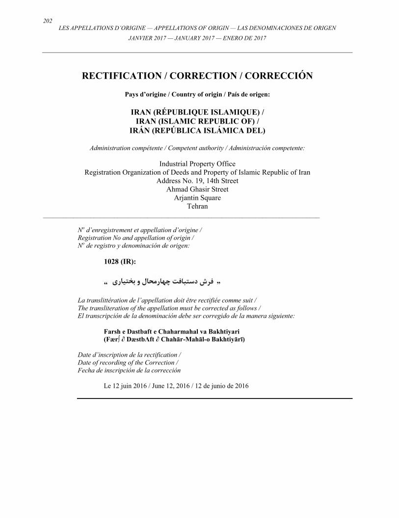
202 LES APPELLATIONS D’ORIGINE — APPELLATIONS OF ORIGIN — LAS DENOMINACIONES DE ORIGEN
JANVIER 2017 — JANUARY 2017 — ENERO DE 2017
RECTIFICATION / CORRECTION / CORRECCIÓN
Pays d’origine / Country of origin / País de origen:
IRAN (RÉPUBLIQUE ISLAMIQUE) / IRAN (ISLAMIC REPUBLIC OF) /
IRÁN (REPÚBLICA ISLÁMICA DEL)
Administration compétente / Competent authority / Administración competente:
Industrial Property Office Registration Organization of Deeds and Property of Islamic Republic of Iran
Address No. 19, 14th Street Ahmad Ghasir Street
Arjantin Square Tehran
__________________________________________________________________________________
No d’enregistrement et appellation d’origine / Registration No and appellation of origin / No de registro y denominación de origen:
1028 (IR):
“ ”
La translittération de l’appellation doit être rectifiée comme suit / The transliteration of the appellation must be corrected as follows / El transcripción de la denominación debe ser corregido de la manera siguiente:
Farsh e Dastbaft e Chaharmahal va Bakhtiyari (Fær∫ ∂ DæstbΛft ∂ Chahār-Mahāl-o Bakhtiyārī)
Date d’inscription de la rectification / Date of recording of the Correction / Fecha de inscripción de la corrección
Le 12 juin 2016 / June 12, 2016 / 12 de junio de 2016
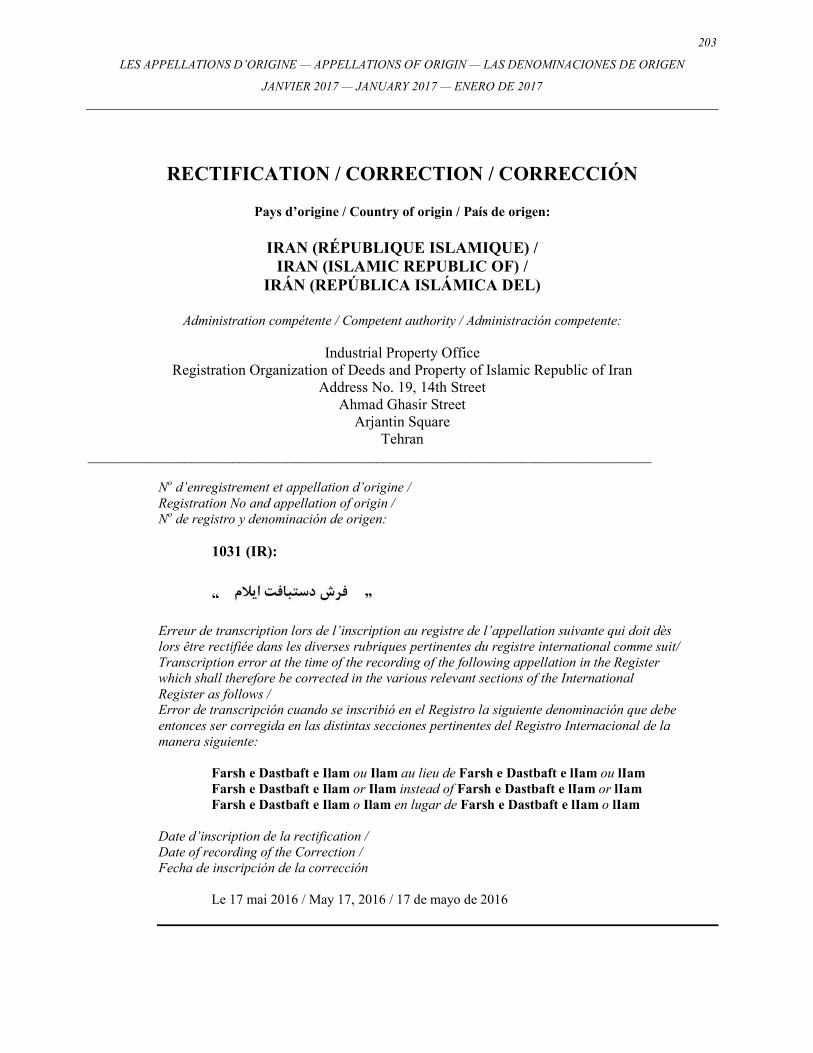
203
LES APPELLATIONS D’ORIGINE — APPELLATIONS OF ORIGIN — LAS DENOMINACIONES DE ORIGEN
JANVIER 2017 — JANUARY 2017 — ENERO DE 2017
RECTIFICATION / CORRECTION / CORRECCIÓN
Pays d’origine / Country of origin / País de origen:
IRAN (RÉPUBLIQUE ISLAMIQUE) / IRAN (ISLAMIC REPUBLIC OF) /
IRÁN (REPÚBLICA ISLÁMICA DEL)
Administration compétente / Competent authority / Administración competente:
Industrial Property Office Registration Organization of Deeds and Property of Islamic Republic of Iran
Address No. 19, 14th Street Ahmad Ghasir Street
Arjantin Square Tehran
__________________________________________________________________________________
No d’enregistrement et appellation d’origine / Registration No and appellation of origin / No de registro y denominación de origen:
1031 (IR):
“ ”
Erreur de transcription lors de l’inscription au registre de l’appellation suivante qui doit dès lors être rectifiée dans les diverses rubriques pertinentes du registre international comme suit/ Transcription error at the time of the recording of the following appellation in the Register which shall therefore be corrected in the various relevant sections of the International Register as follows / Error de transcripción cuando se inscribió en el Registro la siguiente denominación que debe entonces ser corregida en las distintas secciones pertinentes del Registro Internacional de la manera siguiente:
Farsh e Dastbaft e Ilam ou Ilam au lieu de Farsh e Dastbaft e lIam ou lIam Farsh e Dastbaft e Ilam or Ilam instead of Farsh e Dastbaft e lIam or lIam Farsh e Dastbaft e Ilam o Ilam en lugar de Farsh e Dastbaft e lIam o lIam
Date d’inscription de la rectification / Date of recording of the Correction / Fecha de inscripción de la corrección
Le 17 mai 2016 / May 17, 2016 / 17 de mayo de 2016

204 LES APPELLATIONS D’ORIGINE — APPELLATIONS OF ORIGIN — LAS DENOMINACIONES DE ORIGEN
JANVIER 2017 — JANUARY 2017 — ENERO DE 2017
205
LES APPELLATIONS D’ORIGINE — APPELLATIONS OF ORIGIN — LAS DENOMINACIONES DE ORIGEN
JANVIER 2017 — JANUARY 2017 — ENERO DE 2017
STATISTIQUES / STATISTICS / ESTADÍSTICAS
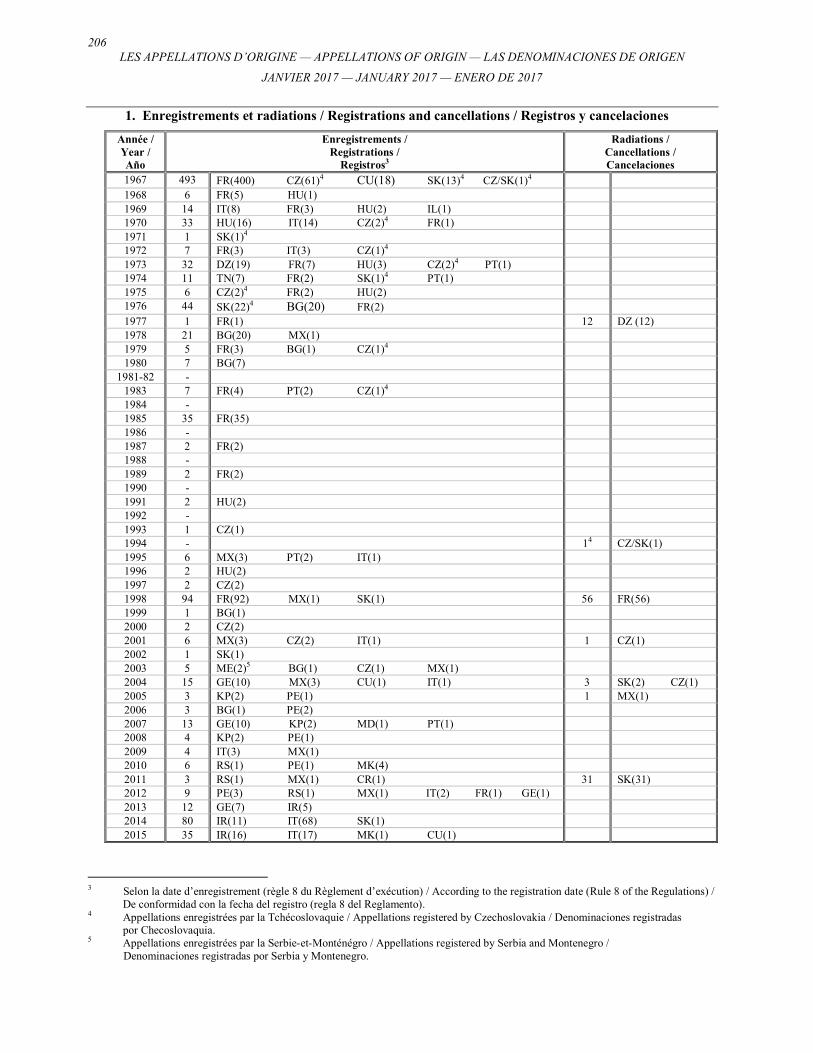
206 LES APPELLATIONS D’ORIGINE — APPELLATIONS OF ORIGIN — LAS DENOMINACIONES DE ORIGEN
JANVIER 2017 — JANUARY 2017 — ENERO DE 2017
1. Enregistrements et radiations / Registrations and cancellations / Registros y cancelaciones
Année / Year / Año
Enregistrements / Registrations /
Registros3
Radiations / Cancellations / Cancelaciones
1967 493 FR(400) CZ(61)4 CU(18) SK(13)4 CZ/SK(1)4 1968 6 FR(5) HU(1) 1969 14 IT(8) FR(3) HU(2) IL(1) 1970 33 HU(16) IT(14) CZ(2)4 FR(1) 1971 1 SK(1)4 1972 7 FR(3) IT(3) CZ(1)4 1973 32 DZ(19) FR(7) HU(3) CZ(2)4 PT(1) 1974 11 TN(7) FR(2) SK(1)4 PT(1) 1975 6 CZ(2)4 FR(2) HU(2) 1976 44 SK(22)4 BG(20) FR(2) 1977 1 FR(1) 12 DZ (12) 1978 21 BG(20) MX(1) 1979 5 FR(3) BG(1) CZ(1)4 1980 7 BG(7)
1981-82 - 1983 7 FR(4) PT(2) CZ(1)4 1984 - 1985 35 FR(35) 1986 - 1987 2 FR(2) 1988 - 1989 2 FR(2) 1990 - 1991 2 HU(2) 1992 - 1993 1 CZ(1) 1994 - 14 CZ/SK(1) 1995 6 MX(3) PT(2) IT(1) 1996 2 HU(2) 1997 2 CZ(2) 1998 94 FR(92) MX(1) SK(1) 56 FR(56) 1999 1 BG(1) 2000 2 CZ(2) 2001 6 MX(3) CZ(2) IT(1) 1 CZ(1) 2002 1 SK(1) 2003 5 ME(2)5 BG(1) CZ(1) MX(1) 2004 15 GE(10) MX(3) CU(1) IT(1) 3 SK(2) CZ(1) 2005 3 KP(2) PE(1) 1 MX(1) 2006 3 BG(1) PE(2) 2007 13 GE(10) KP(2) MD(1) PT(1) 2008 4 KP(2) PE(1) 2009 4 IT(3) MX(1) 2010 6 RS(1) PE(1) MK(4) 2011 3 RS(1) MX(1) CR(1) 31 SK(31) 2012 9 PE(3) RS(1) MX(1) IT(2) FR(1) GE(1) 2013 12 GE(7) IR(5) 2014 80 IR(11) IT(68) SK(1) 2015 35 IR(16) IT(17) MK(1) CU(1)
3 Selon la date d’enregistrement (règle 8 du Règlement d’exécution) / According to the registration date (Rule 8 of the Regulations) / De conformidad con la fecha del registro (regla 8 del Reglamento). 4 Appellations enregistrées par la Tchécoslovaquie / Appellations registered by Czechoslovakia / Denominaciones registradas por Checoslovaquia. 5 Appellations enregistrées par la Serbie-et-Monténégro / Appellations registered by Serbia and Montenegro /
Denominaciones registradas por Serbia y Montenegro.
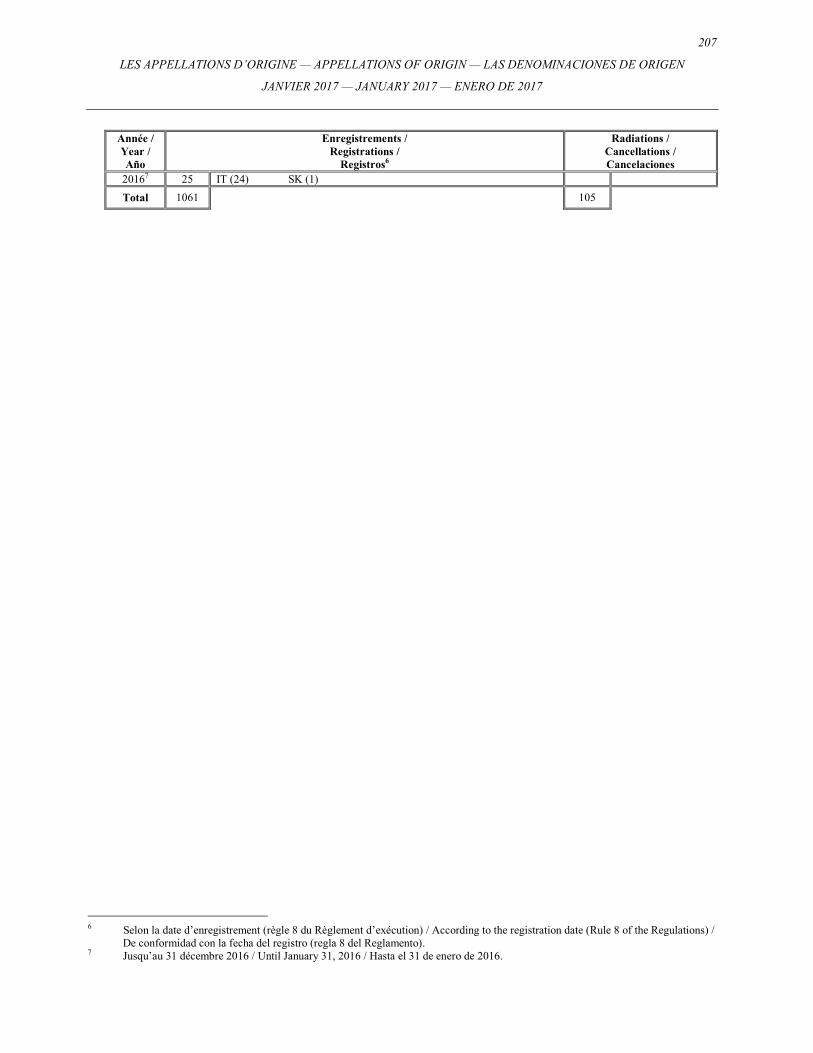
207
LES APPELLATIONS D’ORIGINE — APPELLATIONS OF ORIGIN — LAS DENOMINACIONES DE ORIGEN
JANVIER 2017 — JANUARY 2017 — ENERO DE 2017
Année / Year / Año
Enregistrements / Registrations /
Registros6
Radiations / Cancellations / Cancelaciones
20167 25 IT (24) SK (1)
Total 1061 105
6 Selon la date d’enregistrement (règle 8 du Règlement d’exécution) / According to the registration date (Rule 8 of the Regulations) / De conformidad con la fecha del registro (regla 8 del Reglamento). 7 Jusqu’au 31 décembre 2016 / Until January 31, 2016 / Hasta el 31 de enero de 2016.
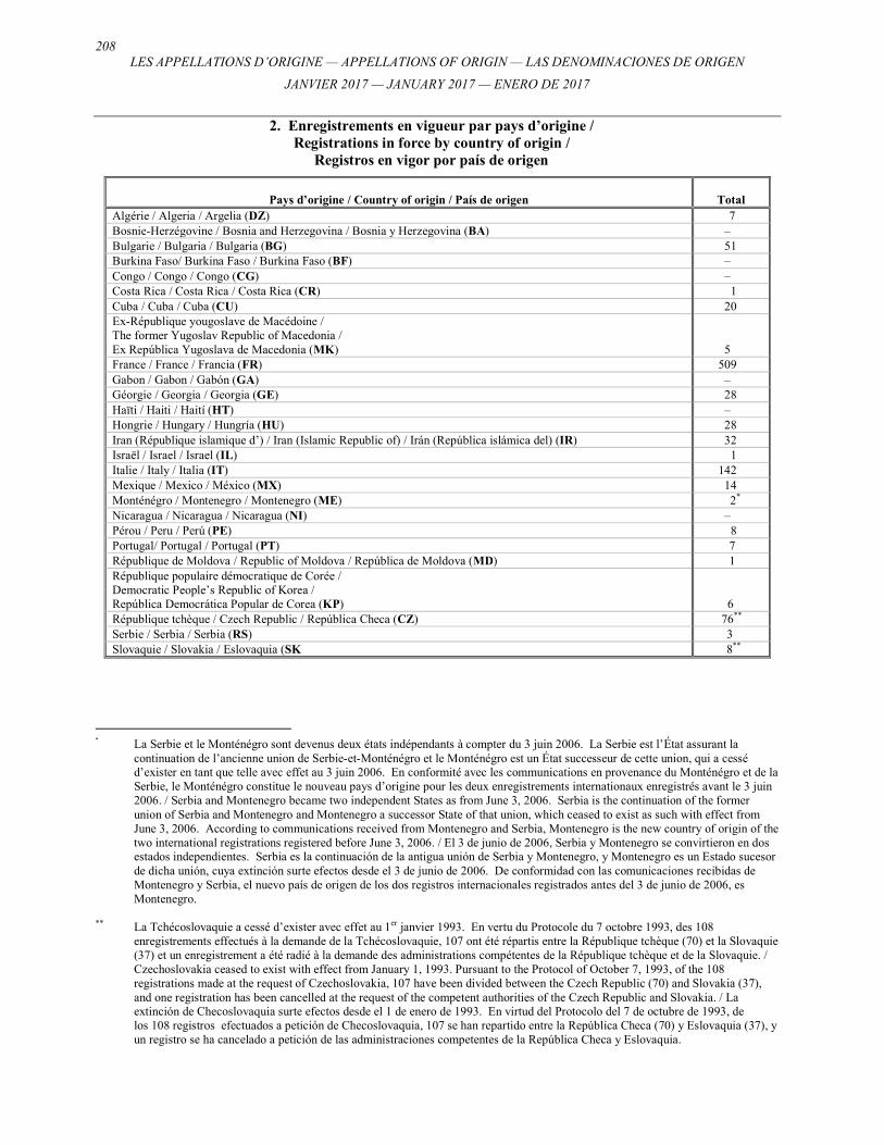
208 LES APPELLATIONS D’ORIGINE — APPELLATIONS OF ORIGIN — LAS DENOMINACIONES DE ORIGEN
JANVIER 2017 — JANUARY 2017 — ENERO DE 2017
2. Enregistrements en vigueur par pays d’origine / Registrations in force by country of origin /
Registros en vigor por país de origen
Pays d’origine / Country of origin / País de origen
Total
Algérie / Algeria / Argelia (DZ) 7 Bosnie-Herzégovine / Bosnia and Herzegovina / Bosnia y Herzegovina (BA) – Bulgarie / Bulgaria / Bulgaria (BG) 51 Burkina Faso/ Burkina Faso / Burkina Faso (BF) – Congo / Congo / Congo (CG) – Costa Rica / Costa Rica / Costa Rica (CR) 1 Cuba / Cuba / Cuba (CU) 20 Ex-République yougoslave de Macédoine / The former Yugoslav Republic of Macedonia / Ex República Yugoslava de Macedonia (MK)
5 France / France / Francia (FR) 509 Gabon / Gabon / Gabón (GA) – Géorgie / Georgia / Georgia (GE) 28 Haïti / Haiti / Haití (HT) – Hongrie / Hungary / Hungría (HU) 28 Iran (République islamique d’) / Iran (Islamic Republic of) / Irán (República islámica del) (IR) 32 Israël / Israel / Israel (IL) 1 Italie / Italy / Italia (IT) 142 Mexique / Mexico / México (MX) 14 Monténégro / Montenegro / Montenegro (ME) 2*
Nicaragua / Nicaragua / Nicaragua (NI) – Pérou / Peru / Perú (PE) 8 Portugal/ Portugal / Portugal (PT) 7 République de Moldova / Republic of Moldova / República de Moldova (MD) 1 République populaire démocratique de Corée / Democratic People’s Republic of Korea / República Democrática Popular de Corea (KP)
6 République tchèque / Czech Republic / República Checa (CZ) 76**
Serbie / Serbia / Serbia (RS) 3
Slovaquie / Slovakia / Eslovaquia (SK 8**
* La Serbie et le Monténégro sont devenus deux états indépendants à compter du 3 juin 2006. La Serbie est l’État assurant la
continuation de l’ancienne union de Serbie-et-Monténégro et le Monténégro est un État successeur de cette union, qui a cessé d’exister en tant que telle avec effet au 3 juin 2006. En conformité avec les communications en provenance du Monténégro et de la Serbie, le Monténégro constitue le nouveau pays d’origine pour les deux enregistrements internationaux enregistrés avant le 3 juin 2006. / Serbia and Montenegro became two independent States as from June 3, 2006. Serbia is the continuation of the former union of Serbia and Montenegro and Montenegro a successor State of that union, which ceased to exist as such with effect from June 3, 2006. According to communications received from Montenegro and Serbia, Montenegro is the new country of origin of the two international registrations registered before June 3, 2006. / El 3 de junio de 2006, Serbia y Montenegro se convirtieron en dos estados independientes. Serbia es la continuación de la antigua unión de Serbia y Montenegro, y Montenegro es un Estado sucesor de dicha unión, cuya extinción surte efectos desde el 3 de junio de 2006. De conformidad con las comunicaciones recibidas de Montenegro y Serbia, el nuevo país de origen de los dos registros internacionales registrados antes del 3 de junio de 2006, es Montenegro.
** La Tchécoslovaquie a cessé d’exister avec effet au 1er janvier 1993. En vertu du Protocole du 7 octobre 1993, des 108
enregistrements effectués à la demande de la Tchécoslovaquie, 107 ont été répartis entre la République tchèque (70) et la Slovaquie (37) et un enregistrement a été radié à la demande des administrations compétentes de la République tchèque et de la Slovaquie. / Czechoslovakia ceased to exist with effect from January 1, 1993. Pursuant to the Protocol of October 7, 1993, of the 108 registrations made at the request of Czechoslovakia, 107 have been divided between the Czech Republic (70) and Slovakia (37), and one registration has been cancelled at the request of the competent authorities of the Czech Republic and Slovakia. / La extinción de Checoslovaquia surte efectos desde el 1 de enero de 1993. En virtud del Protocolo del 7 de octubre de 1993, de los 108 registros efectuados a petición de Checoslovaquia, 107 se han repartido entre la República Checa (70) y Eslovaquia (37), y un registro se ha cancelado a petición de las administraciones competentes de la República Checa y Eslovaquia.
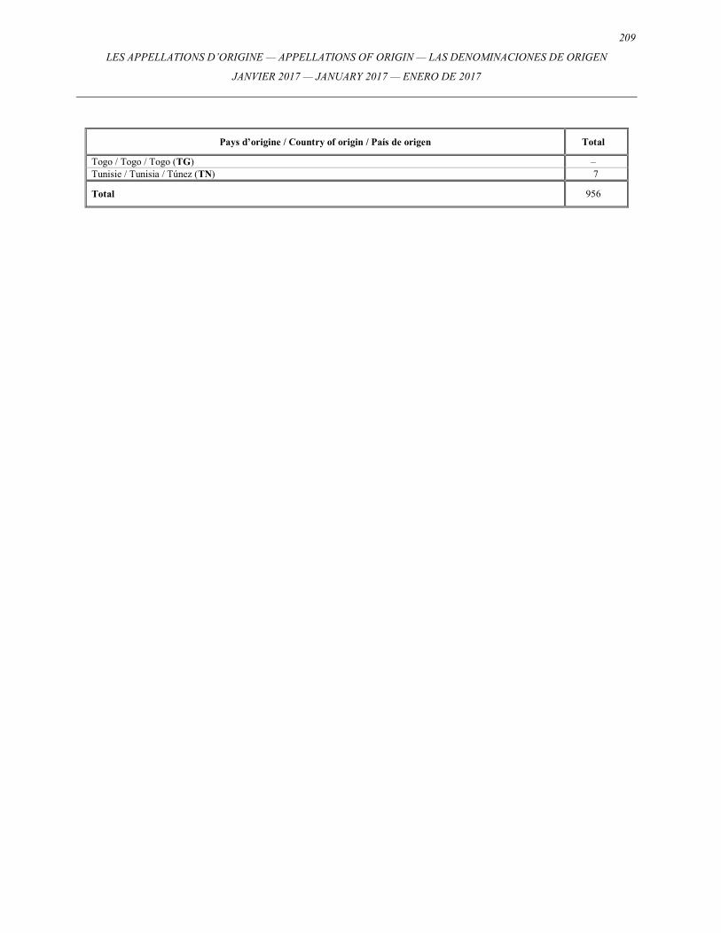
209
LES APPELLATIONS D’ORIGINE — APPELLATIONS OF ORIGIN — LAS DENOMINACIONES DE ORIGEN
JANVIER 2017 — JANUARY 2017 — ENERO DE 2017
Pays d’origine / Country of origin / País de origen Total
Togo / Togo / Togo (TG) – Tunisie / Tunisia / Túnez (TN) 7
Total 956
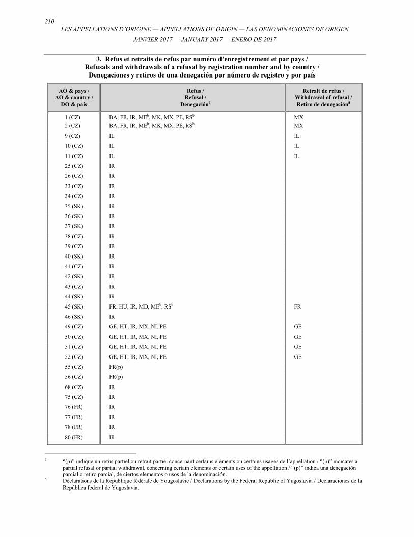
210 LES APPELLATIONS D’ORIGINE — APPELLATIONS OF ORIGIN — LAS DENOMINACIONES DE ORIGEN
JANVIER 2017 — JANUARY 2017 — ENERO DE 2017
3. Refus et retraits de refus par numéro d’enregistrement et par pays / Refusals and withdrawals of a refusal by registration number and by country /
Denegaciones y retiros de una denegación por número de registro y por país
AO & pays / AO & country /
DO & país
Refus / Refusal /
Denegacióna
Retrait de refus / Withdrawal of refusal / Retiro de denegacióna
1 (CZ) BA, FR, IR, MEb, MK, MX, PE, RSb MX
2 (CZ) BA, FR, IR, MEb, MK, MX, PE, RSb MX
9 (CZ) IL IL
10 (CZ) IL IL
11 (CZ) IL IL
25 (CZ) IR
26 (CZ) IR
33 (CZ) IR
34 (CZ) IR
35 (SK) IR
36 (SK) IR
37 (SK) IR
38 (CZ) IR
39 (CZ) IR
40 (SK) IR
41 (CZ) IR
42 (SK) IR
43 (CZ) IR
44 (SK) IR
45 (SK) FR, HU, IR, MD, MEb, RSb FR
46 (SK) IR
49 (CZ) GE, HT, IR, MX, NI, PE GE
50 (CZ) GE, HT, IR, MX, NI, PE GE
51 (CZ) GE, HT, IR, MX, NI, PE GE
52 (CZ) GE, HT, IR, MX, NI, PE GE
55 (CZ) FR(p)
56 (CZ) FR(p)
68 (CZ) IR
75 (CZ) IR
76 (FR) IR
77 (FR) IR
78 (FR) IR
80 (FR) IR
a “(p)” indique un refus partiel ou retrait partiel concernant certains éléments ou certains usages de l’appellation / “(p)” indicates a
partial refusal or partial withdrawal, concerning certain elements or certain uses of the appellation / “(p)” indica una denegación parcial o retiro parcial, de ciertos elementos o usos de la denominación.
b Déclarations de la République fédérale de Yougoslavie / Declarations by the Federal Republic of Yugoslavia / Declaraciones de la República federal de Yugoslavia.

211
LES APPELLATIONS D’ORIGINE — APPELLATIONS OF ORIGIN — LAS DENOMINACIONES DE ORIGEN
JANVIER 2017 — JANUARY 2017 — ENERO DE 2017
AO & pays / AO & country /
DO & país
Refus / Refusal /
Denegacióna
Retrait de refus / Withdrawal of refusal / Retiro de denegacióna
81 (FR) IR
82 (FR) IR
84 (FR) IR
85 (FR) IR
86 (FR) IR
87 (FR) IR
88 (FR) IR
89 (FR) IR
90 (FR) IR
91 (FR) IR
92 (FR) IR
93 (FR) IR
94 (FR) IR
95 (FR) IR
97 (FR) CU, IR CU
98 (FR) IR
99 (FR) IR
100 (FR) IR
101 (FR) IR
102 (FR) IR, MX MX
103 (FR) IR
105 (FR) IR
106 (FR) IR
107 (FR) IR
108 (FR) IR, MX MX
109 (FR) IR
110 (FR) IR
111 (FR) IR, MX MX
112 (FR) IR
114 (FR) IR
115 (FR) IR
116 (FR) IR
117 (FR) IR
118 (FR) IR
119 (FR) IR
120 (FR) IR
122 (FR) IR
123 (FR) IR
124 (FR) IR
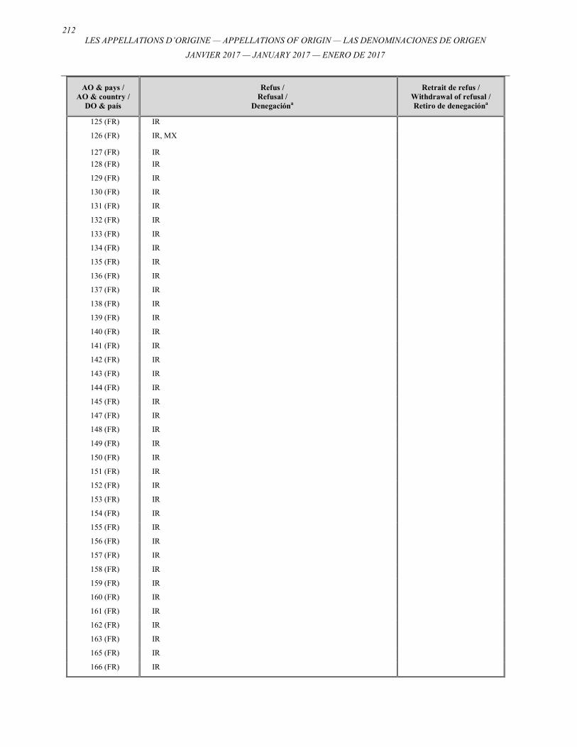
212 LES APPELLATIONS D’ORIGINE — APPELLATIONS OF ORIGIN — LAS DENOMINACIONES DE ORIGEN
JANVIER 2017 — JANUARY 2017 — ENERO DE 2017
AO & pays / AO & country /
DO & país
Refus / Refusal /
Denegacióna
Retrait de refus / Withdrawal of refusal / Retiro de denegacióna
125 (FR) IR
126 (FR) IR, MX
127 (FR) IR
128 (FR) IR
129 (FR) IR
130 (FR) IR
131 (FR) IR
132 (FR) IR
133 (FR) IR
134 (FR) IR
135 (FR) IR
136 (FR) IR
137 (FR) IR
138 (FR) IR
139 (FR) IR
140 (FR) IR
141 (FR) IR
142 (FR) IR
143 (FR) IR
144 (FR) IR
145 (FR) IR
147 (FR) IR
148 (FR) IR
149 (FR) IR
150 (FR) IR
151 (FR) IR
152 (FR) IR
153 (FR) IR
154 (FR) IR
155 (FR) IR
156 (FR) IR
157 (FR) IR
158 (FR) IR
159 (FR) IR
160 (FR) IR
161 (FR) IR
162 (FR) IR
163 (FR) IR
165 (FR) IR
166 (FR) IR

213
LES APPELLATIONS D’ORIGINE — APPELLATIONS OF ORIGIN — LAS DENOMINACIONES DE ORIGEN
JANVIER 2017 — JANUARY 2017 — ENERO DE 2017
AO & pays / AO & country /
DO & país
Refus / Refusal /
Denegacióna
Retrait de refus / Withdrawal of refusal / Retiro de denegacióna
167 (FR) IR
168 (FR) IR
169 (FR) IR
170 (FR) IR
171 (FR) IR
172 (FR) IR
173 (FR) IR
174 (FR) IR
175 (FR) IR
176 (FR) IR
177 (FR) IR
178 (FR) IR
179 (FR) IR
180 (FR) IR
182 (FR) IR
183 (FR) IR
184 (FR) CU, IR CU
185 (FR) IR
186 (FR) IR
187 (FR) IR
188 (FR) IR
189 (FR) IR
191 (FR) CU, IR CU
192 (FR) IR
193 (FR) IR
194 (FR) IR
195 (FR) IR
196 (FR) IR
197 (FR) IR
198 (FR) IR
199 (FR) IR
200 (FR) IR
201 (FR) IR
202 (FR) IR
203 (FR) IR
204 (FR) IR
205 (FR) CU, IR CU
206 (FR) IR
207 (FR) CU, IR CU
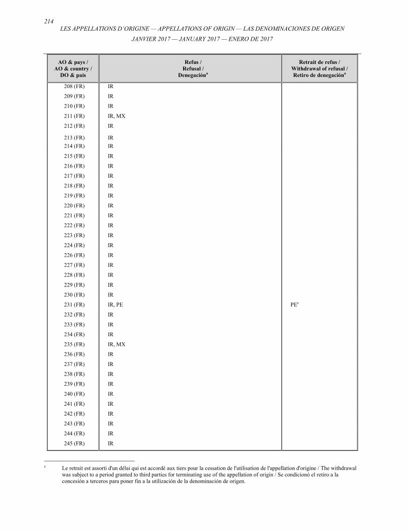
214 LES APPELLATIONS D’ORIGINE — APPELLATIONS OF ORIGIN — LAS DENOMINACIONES DE ORIGEN
JANVIER 2017 — JANUARY 2017 — ENERO DE 2017
AO & pays / AO & country /
DO & país
Refus / Refusal /
Denegacióna
Retrait de refus / Withdrawal of refusal / Retiro de denegacióna
208 (FR) IR
209 (FR) IR
210 (FR) IR
211 (FR) IR, MX
212 (FR) IR
213 (FR) IR
214 (FR) IR
215 (FR) IR
216 (FR) IR
217 (FR) IR
218 (FR) IR
219 (FR) IR
220 (FR) IR
221 (FR) IR
222 (FR) IR
223 (FR) IR
224 (FR) IR
226 (FR) IR
227 (FR) IR
228 (FR) IR
229 (FR) IR
230 (FR) IR
231 (FR) IR, PE PEc
232 (FR) IR
233 (FR) IR
234 (FR) IR
235 (FR) IR, MX
236 (FR) IR
237 (FR) IR
238 (FR) IR
239 (FR) IR
240 (FR) IR
241 (FR) IR
242 (FR) IR
243 (FR) IR
244 (FR) IR
245 (FR) IR
c Le retrait est assorti d'un délai qui est accordé aux tiers pour la cessation de l'utilisation de l'appellation d'origine / The withdrawal
was subject to a period granted to third parties for terminating use of the appellation of origin / Se condicionó el retiro a la concesión a terceros para poner fin a la utilización de la denominación de origen.
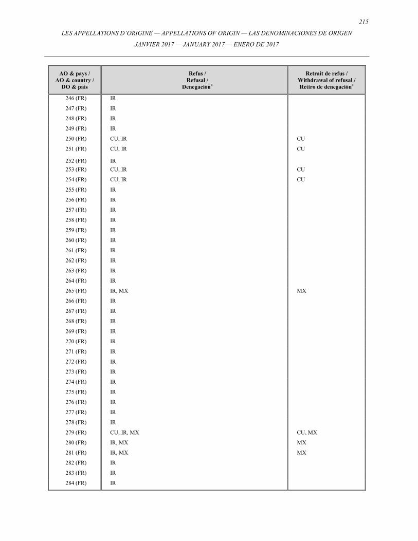
215
LES APPELLATIONS D’ORIGINE — APPELLATIONS OF ORIGIN — LAS DENOMINACIONES DE ORIGEN
JANVIER 2017 — JANUARY 2017 — ENERO DE 2017
AO & pays / AO & country /
DO & país
Refus / Refusal /
Denegacióna
Retrait de refus / Withdrawal of refusal / Retiro de denegacióna
246 (FR) IR
247 (FR) IR
248 (FR) IR
249 (FR) IR
250 (FR) CU, IR CU
251 (FR) CU, IR CU
252 (FR) IR
253 (FR) CU, IR CU
254 (FR) CU, IR CU
255 (FR) IR
256 (FR) IR
257 (FR) IR
258 (FR) IR
259 (FR) IR
260 (FR) IR
261 (FR) IR
262 (FR) IR
263 (FR) IR
264 (FR) IR
265 (FR) IR, MX MX
266 (FR) IR
267 (FR) IR
268 (FR) IR
269 (FR) IR
270 (FR) IR
271 (FR) IR
272 (FR) IR
273 (FR) IR
274 (FR) IR
275 (FR) IR
276 (FR) IR
277 (FR) IR
278 (FR) IR
279 (FR) CU, IR, MX CU, MX
280 (FR) IR, MX MX
281 (FR) IR, MX MX
282 (FR) IR
283 (FR) IR
284 (FR) IR
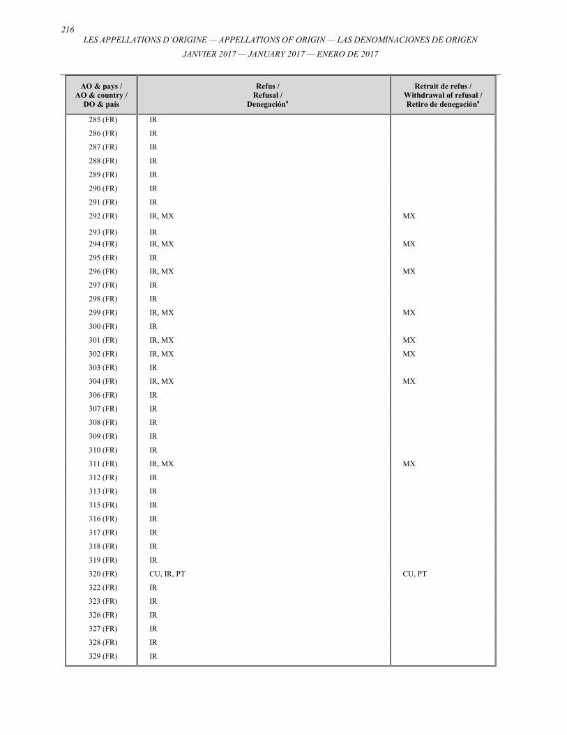
216 LES APPELLATIONS D’ORIGINE — APPELLATIONS OF ORIGIN — LAS DENOMINACIONES DE ORIGEN
JANVIER 2017 — JANUARY 2017 — ENERO DE 2017
AO & pays / AO & country /
DO & país
Refus / Refusal /
Denegacióna
Retrait de refus / Withdrawal of refusal / Retiro de denegacióna
285 (FR) IR
286 (FR) IR
287 (FR) IR
288 (FR) IR
289 (FR) IR
290 (FR) IR
291 (FR) IR
292 (FR) IR, MX MX
293 (FR) IR
294 (FR) IR, MX MX
295 (FR) IR
296 (FR) IR, MX MX
297 (FR) IR
298 (FR) IR
299 (FR) IR, MX MX
300 (FR) IR
301 (FR) IR, MX MX
302 (FR) IR, MX MX
303 (FR) IR
304 (FR) IR, MX MX
306 (FR) IR
307 (FR) IR
308 (FR) IR
309 (FR) IR
310 (FR) IR
311 (FR) IR, MX MX
312 (FR) IR
313 (FR) IR
315 (FR) IR
316 (FR) IR
317 (FR) IR
318 (FR) IR
319 (FR) IR
320 (FR) CU, IR, PT CU, PT
322 (FR) IR
323 (FR) IR
326 (FR) IR
327 (FR) IR
328 (FR) IR
329 (FR) IR

217
LES APPELLATIONS D’ORIGINE — APPELLATIONS OF ORIGIN — LAS DENOMINACIONES DE ORIGEN
JANVIER 2017 — JANUARY 2017 — ENERO DE 2017
AO & pays / AO & country /
DO & país
Refus / Refusal /
Denegacióna
Retrait de refus / Withdrawal of refusal / Retiro de denegacióna
330 (FR) IR
331 (FR) IR
332 (FR) IR
333 (FR) IR
334 (FR) IR
335 (FR) IR
336 (FR) IR
337 (FR) IR
338 (FR) IR
339 (FR) IR
340 (FR) IR
341 (FR) IR
342 (FR) IR
343 (FR) IR
344 (FR) IR
345 (FR) IR, PE(p) PEc
346 (FR) IR, PE(p) PEc
347 (FR) IR, PE(p) PEc
348 (FR) IR
349 (FR) IR
350 (FR) IR
351 (FR) IR
352 (FR) IR
353 (FR) IR
357 (FR) IR
358 (FR) IR
360 (FR) IR
361 (FR) IR
362 (FR) IR
363 (FR) IR
364 (FR) IR
368 (FR) IR
372 (FR) IR
374 (FR) IR
379 (FR) IR
380 (FR) IR, MX MX
386 (FR) IR
390 (FR) IR
391 (FR) IR

218 LES APPELLATIONS D’ORIGINE — APPELLATIONS OF ORIGIN — LAS DENOMINACIONES DE ORIGEN
JANVIER 2017 — JANUARY 2017 — ENERO DE 2017
AO & pays / AO & country /
DO & país
Refus / Refusal /
Denegacióna
Retrait de refus / Withdrawal of refusal / Retiro de denegacióna
392 (FR) IR
393 (FR) IR
394 (FR) IR
395 (FR) IR
396 (FR) IR
398 (FR) IR
401 (FR) IR
407 (FR) IR
408 (FR) IR
411 (FR) IR
413 (FR) IR
414 (FR) IR
415 (FR) IR
416 (FR) IR
417 (FR) IR
418 (FR) IR
420 (FR) IR
421 (FR) IR
422 (FR) IR
423 (FR) IR
424 (FR) IR
425 (FR) IR
426 (FR) IR
427 (FR) IR
428 (FR) IR
429 (FR) IR
430 (FR) IR
431 (FR) IR
432 (FR) CZ/SKd , IR CZ/SKd
433 (FR) IR
434 (FR) IR
435 (FR) IR
436 (FR) IR
437 (FR) IR
438 (FR) IR
439 (FR) IR, PE(p) PEc
440 (FR) IR
441 (FR) IR
d Déclarations par la Tchécoslovaquie / Declarations by Czechoslovakia / Declaraciones de la Checoslovaquia.
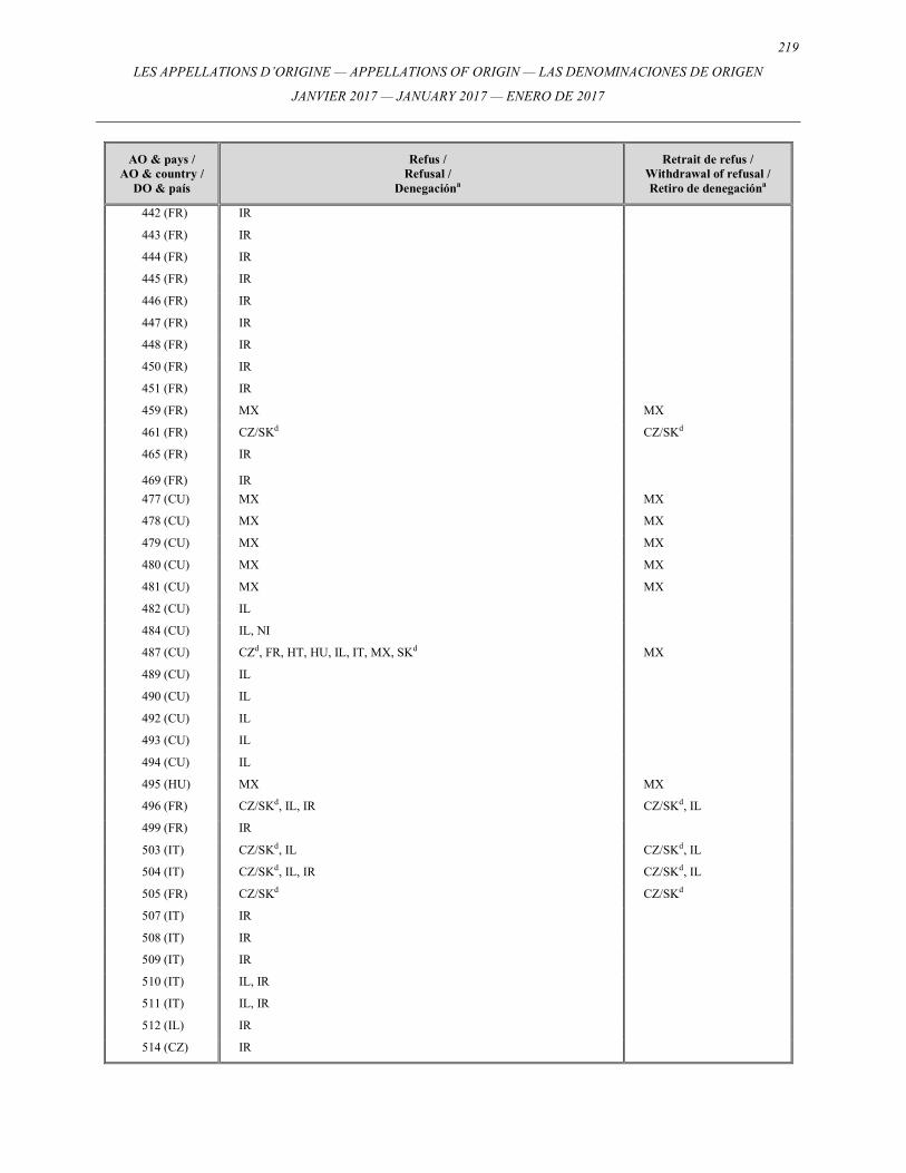
219
LES APPELLATIONS D’ORIGINE — APPELLATIONS OF ORIGIN — LAS DENOMINACIONES DE ORIGEN
JANVIER 2017 — JANUARY 2017 — ENERO DE 2017
AO & pays / AO & country /
DO & país
Refus / Refusal /
Denegacióna
Retrait de refus / Withdrawal of refusal / Retiro de denegacióna
442 (FR) IR
443 (FR) IR
444 (FR) IR
445 (FR) IR
446 (FR) IR
447 (FR) IR
448 (FR) IR
450 (FR) IR
451 (FR) IR
459 (FR) MX MX
461 (FR) CZ/SKd CZ/SKd
465 (FR) IR
469 (FR) IR
477 (CU) MX MX
478 (CU) MX MX
479 (CU) MX MX
480 (CU) MX MX
481 (CU) MX MX
482 (CU) IL
484 (CU) IL, NI
487 (CU) CZd, FR, HT, HU, IL, IT, MX, SKd MX
489 (CU) IL
490 (CU) IL
492 (CU) IL
493 (CU) IL
494 (CU) IL
495 (HU) MX MX
496 (FR) CZ/SKd, IL, IR CZ/SKd, IL
499 (FR) IR
503 (IT) CZ/SKd, IL CZ/SKd, IL
504 (IT) CZ/SKd, IL, IR CZ/SKd, IL
505 (FR) CZ/SKd CZ/SKd
507 (IT) IR
508 (IT) IR
509 (IT) IR
510 (IT) IL, IR
511 (IT) IL, IR
512 (IL) IR
514 (CZ) IR

220 LES APPELLATIONS D’ORIGINE — APPELLATIONS OF ORIGIN — LAS DENOMINACIONES DE ORIGEN
JANVIER 2017 — JANUARY 2017 — ENERO DE 2017
AO & pays / AO & country /
DO & país
Refus / Refusal /
Denegacióna
Retrait de refus / Withdrawal of refusal / Retiro de denegacióna
515 (CZ) IR
516 (IT) IR
517 (IT) IR
518 (IT) IR
519 (IT) IR
520 (IT) IR
521 (IT) IR
522 (IT) IR
523 (IT) IR
524 (IT) IR
525 (IT) IR
526 (IT) IR
527 (HU) IR
528 (HU) IR
529 (HU) IR
530 (HU) IR
531 (HU) IR
532 (HU) IR
533 (HU) IR
534 (HU) IR
535 (HU) IR
536 (HU) IR
537 (HU) IR
538 (HU) IR
539 (HU) IR
540 (HU) IR
541 (HU) IR
542 (HU) IR
544 (IT) IR
545 (IT) IR
546 (IT) IR
548 (IT) IR
549 (IT) IR
550 (IT) IR
554 (FR) IR
556 (FR) IR
564 (PT) CZd, IR, SKd
565 (DZ) IR
569 (DZ) IR
570 (DZ) IR

221
LES APPELLATIONS D’ORIGINE — APPELLATIONS OF ORIGIN — LAS DENOMINACIONES DE ORIGEN
JANVIER 2017 — JANUARY 2017 — ENERO DE 2017
AO & pays / AO & country /
DO & país
Refus / Refusal /
Denegacióna
Retrait de refus / Withdrawal of refusal / Retiro de denegacióna
573 (DZ) IR
578 (DZ) IR
582 (DZ) IR
583 (DZ) IR
586 (HU) CZ/SKd CZ/SKd
588 (PT) IR
589 (TN) IR
590 (TN) IR
591 (TN) IR
592 (TN) IR
593 (TN) IR
594 (TN) IR
595 (TN) IR
598 (CZ) BA, GE, HT, IR, MD, MEb, MK, NI, PE, RSb
599 (CZ) IR
600 (HU) IR
601 (HU) IR
606 (SK) IR
607 (SK) IR
608 (SK) IR
609 (SK) IR
610 (SK) IR
611 (SK) IR
612 (SK) IR
613 (SK) IR
614 (SK) IR, MD
615 (SK) IR
616 (SK) IR
617 (SK) IR
618 (SK) IR
619 (SK) IR
620 (SK) IR
621 (SK) IR
622 (SK) IR
623 (SK) IR
624 (SK) IR
625 (SK) IR
626 (SK) IR
627 (SK) IR
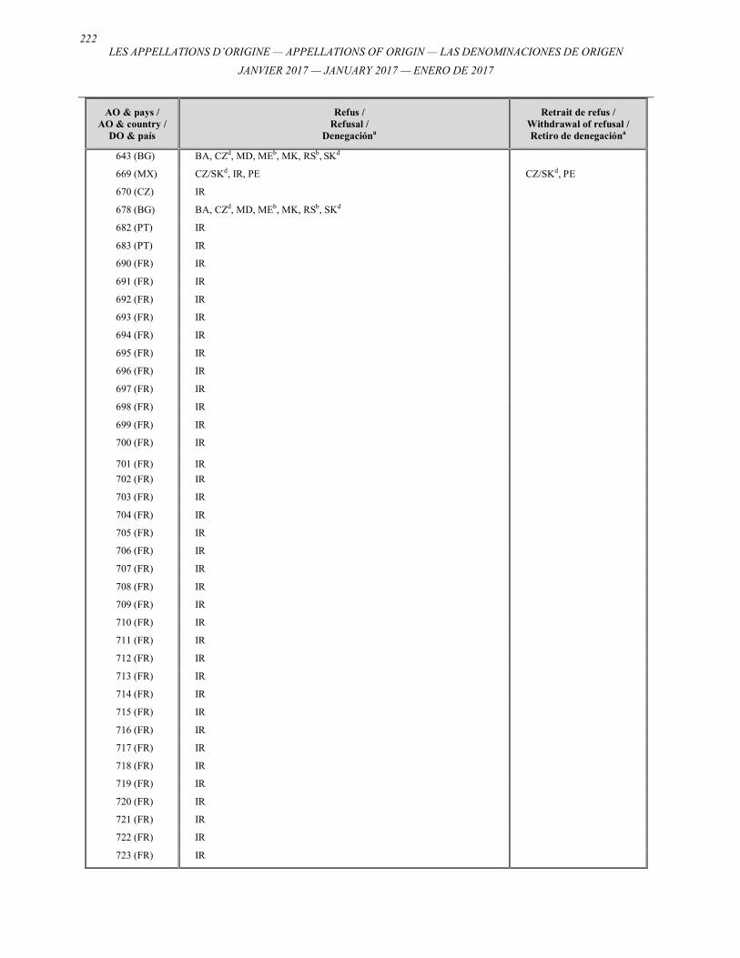
222 LES APPELLATIONS D’ORIGINE — APPELLATIONS OF ORIGIN — LAS DENOMINACIONES DE ORIGEN
JANVIER 2017 — JANUARY 2017 — ENERO DE 2017
AO & pays / AO & country /
DO & país
Refus / Refusal /
Denegacióna
Retrait de refus / Withdrawal of refusal / Retiro de denegacióna
643 (BG) BA, CZd, MD, MEb, MK, RSb, SKd
669 (MX) CZ/SKd, IR, PE CZ/SKd, PE
670 (CZ) IR
678 (BG) BA, CZd, MD, MEb, MK, RSb, SKd
682 (PT) IR
683 (PT) IR
690 (FR) IR
691 (FR) IR
692 (FR) IR
693 (FR) IR
694 (FR) IR
695 (FR) IR
696 (FR) IR
697 (FR) IR
698 (FR) IR
699 (FR) IR
700 (FR) IR
701 (FR) IR
702 (FR) IR
703 (FR) IR
704 (FR) IR
705 (FR) IR
706 (FR) IR
707 (FR) IR
708 (FR) IR
709 (FR) IR
710 (FR) IR
711 (FR) IR
712 (FR) IR
713 (FR) IR
714 (FR) IR
715 (FR) IR
716 (FR) IR
717 (FR) IR
718 (FR) IR
719 (FR) IR
720 (FR) IR
721 (FR) IR
722 (FR) IR
723 (FR) IR

223
LES APPELLATIONS D’ORIGINE — APPELLATIONS OF ORIGIN — LAS DENOMINACIONES DE ORIGEN
JANVIER 2017 — JANUARY 2017 — ENERO DE 2017
AO & pays / AO & country /
DO & país
Refus / Refusal /
Denegacióna
Retrait de refus / Withdrawal of refusal / Retiro de denegacióna
731 (MX) IR
735 (PT) IR
736 (PT) IR
740 (CZ) IR
741 (FR) IR
742 (FR) IR
743 (FR) IR
744 (FR) IR
745 (FR) IR
746 (FR) IR
747 (FR) IR
748 (FR) IR
749 (FR) IR
750 (FR) IR
751 (FR) IR
752 (FR) IR
753 (FR) IR
754 (FR) IR
755 (FR) IR
756 (FR) IR
757 (FR) IR
758 (FR) IR
759 (FR) IR
760 (FR) IR
761 (FR) IR
762 (FR) IR
763 (FR) IR
764 (FR) IR
765 (FR) IR
766 (FR) IR
767 (FR) IR
768 (FR) IR
769 (FR) IR
770 (FR) IR
771 (FR) IR
772 (FR) IR
773 (FR) IR
774 (FR) IR
775 (FR) IR
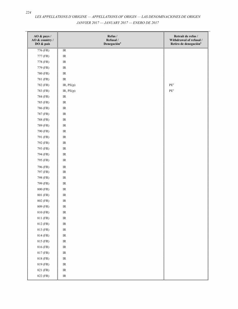
224 LES APPELLATIONS D’ORIGINE — APPELLATIONS OF ORIGIN — LAS DENOMINACIONES DE ORIGEN
JANVIER 2017 — JANUARY 2017 — ENERO DE 2017
AO & pays / AO & country /
DO & país
Refus / Refusal /
Denegacióna
Retrait de refus / Withdrawal of refusal / Retiro de denegacióna
776 (FR) IR
777 (FR) IR
778 (FR) IR
779 (FR) IR
780 (FR) IR
781 (FR) IR
782 (FR) IR, PE(p) PEc
783 (FR) IR, PE(p) PEc
784 (FR) IR
785 (FR) IR
786 (FR) IR
787 (FR) IR
788 (FR) IR
789 (FR) IR
790 (FR) IR
791 (FR) IR
792 (FR) IR
793 (FR) IR
794 (FR) IR
795 (FR) IR
796 (FR) IR
797 (FR) IR
798 (FR) IR
799 (FR) IR
800 (FR) IR
801 (FR) IR
802 (FR) IR
809 (FR) IR
810 (FR) IR
811 (FR) IR
812 (FR) IR
813 (FR) IR
814 (FR) IR
815 (FR) IR
816 (FR) IR
817 (FR) IR
818 (FR) IR
819 (FR) IR
821 (FR) IR
822 (FR) IR
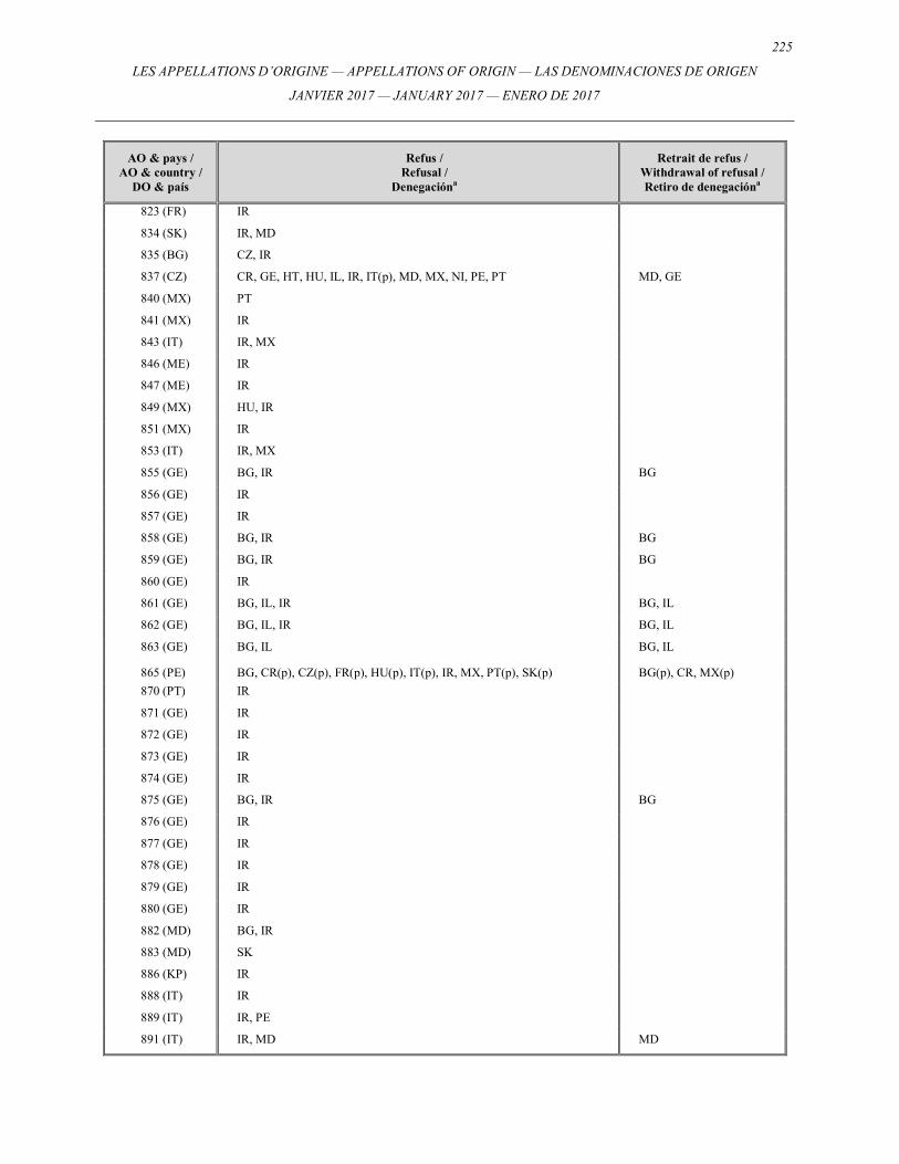
225
LES APPELLATIONS D’ORIGINE — APPELLATIONS OF ORIGIN — LAS DENOMINACIONES DE ORIGEN
JANVIER 2017 — JANUARY 2017 — ENERO DE 2017
AO & pays / AO & country /
DO & país
Refus / Refusal /
Denegacióna
Retrait de refus / Withdrawal of refusal / Retiro de denegacióna
823 (FR) IR
834 (SK) IR, MD
835 (BG) CZ, IR
837 (CZ) CR, GE, HT, HU, IL, IR, IT(p), MD, MX, NI, PE, PT MD, GE
840 (MX) PT
841 (MX) IR
843 (IT) IR, MX
846 (ME) IR
847 (ME) IR
849 (MX) HU, IR
851 (MX) IR
853 (IT) IR, MX
855 (GE) BG, IR BG
856 (GE) IR
857 (GE) IR
858 (GE) BG, IR BG
859 (GE) BG, IR BG
860 (GE) IR
861 (GE) BG, IL, IR BG, IL
862 (GE) BG, IL, IR BG, IL
863 (GE) BG, IL BG, IL
865 (PE) BG, CR(p), CZ(p), FR(p), HU(p), IT(p), IR, MX, PT(p), SK(p) BG(p), CR, MX(p)
870 (PT) IR
871 (GE) IR
872 (GE) IR
873 (GE) IR
874 (GE) IR
875 (GE) BG, IR BG
876 (GE) IR
877 (GE) IR
878 (GE) IR
879 (GE) IR
880 (GE) IR
882 (MD) BG, IR
883 (MD) SK
886 (KP) IR
888 (IT) IR
889 (IT) IR, PE
891 (IT) IR, MD MD
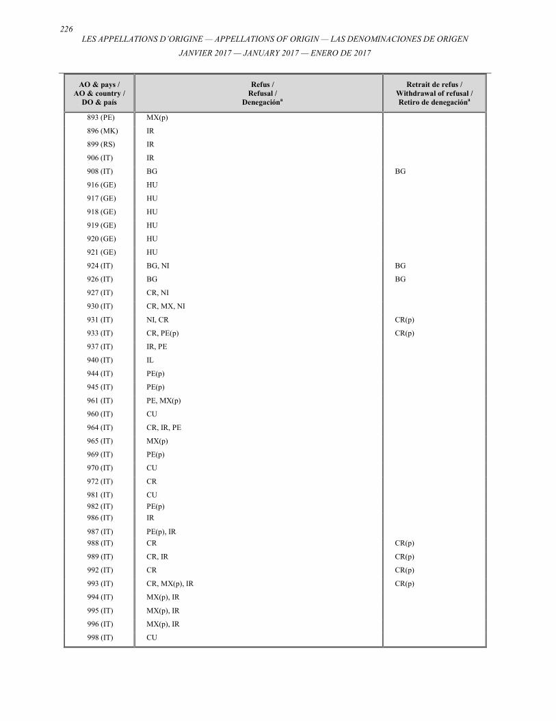
226 LES APPELLATIONS D’ORIGINE — APPELLATIONS OF ORIGIN — LAS DENOMINACIONES DE ORIGEN
JANVIER 2017 — JANUARY 2017 — ENERO DE 2017
AO & pays / AO & country /
DO & país
Refus / Refusal /
Denegacióna
Retrait de refus / Withdrawal of refusal / Retiro de denegacióna
893 (PE) MX(p)
896 (MK) IR
899 (RS) IR
906 (IT) IR
908 (IT) BG BG
916 (GE) HU
917 (GE) HU
918 (GE) HU
919 (GE) HU
920 (GE) HU
921 (GE) HU
924 (IT) BG, NI BG
926 (IT) BG BG
927 (IT) CR, NI
930 (IT) CR, MX, NI
931 (IT) NI, CR CR(p)
933 (IT) CR, PE(p) CR(p)
937 (IT) IR, PE
940 (IT) IL
944 (IT) PE(p)
945 (IT) PE(p)
961 (IT) PE, MX(p)
960 (IT) CU
964 (IT) CR, IR, PE
965 (IT) MX(p)
969 (IT) PE(p)
970 (IT) CU
972 (IT) CR
981 (IT) CU
982 (IT) PE(p)
986 (IT) IR
987 (IT) PE(p), IR
988 (IT) CR CR(p)
989 (IT) CR, IR CR(p)
992 (IT) CR CR(p)
993 (IT) CR, MX(p), IR CR(p)
994 (IT) MX(p), IR
995 (IT) MX(p), IR
996 (IT) MX(p), IR
998 (IT) CU
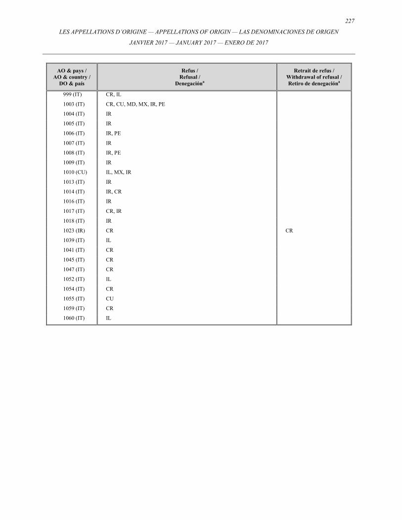
227
LES APPELLATIONS D’ORIGINE — APPELLATIONS OF ORIGIN — LAS DENOMINACIONES DE ORIGEN
JANVIER 2017 — JANUARY 2017 — ENERO DE 2017
AO & pays / AO & country /
DO & país
Refus / Refusal /
Denegacióna
Retrait de refus / Withdrawal of refusal / Retiro de denegacióna
999 (IT) CR, IL
1003 (IT) CR, CU, MD, MX, IR, PE
1004 (IT) IR
1005 (IT) IR
1006 (IT) IR, PE
1007 (IT) IR
1008 (IT) IR, PE
1009 (IT) IR
1010 (CU) IL, MX, IR
1013 (IT) IR
1014 (IT) IR, CR
1016 (IT) IR
1017 (IT) CR, IR
1018 (IT) IR
1023 (IR) CR CR
1039 (IT) IL
1041 (IT) CR
1045 (IT) CR
1047 (IT) CR
1052 (IT) IL
1054 (IT) CR
1055 (IT) CU
1059 (IT) CR
1060 (IT) IL
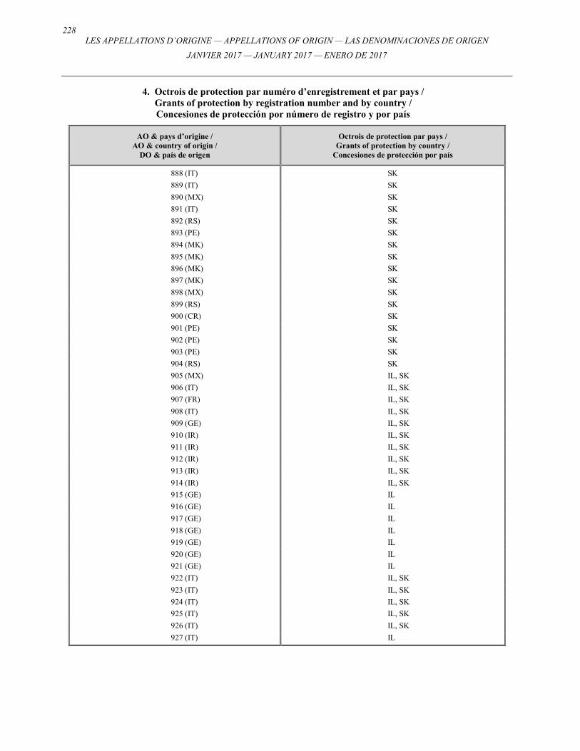
228 LES APPELLATIONS D’ORIGINE — APPELLATIONS OF ORIGIN — LAS DENOMINACIONES DE ORIGEN
JANVIER 2017 — JANUARY 2017 — ENERO DE 2017
4. Octrois de protection par numéro d’enregistrement et par pays / Grants of protection by registration number and by country / Concesiones de protección por número de registro y por país
AO & pays d’origine / AO & country of origin /
DO & país de origen
Octrois de protection par pays / Grants of protection by country /
Concesiones de protección por país
888 (IT) SK
889 (IT) SK
890 (MX) SK
891 (IT) SK
892 (RS) SK
893 (PE) SK
894 (MK) SK
895 (MK) SK
896 (MK) SK
897 (MK) SK
898 (MX) SK
899 (RS) SK
900 (CR) SK
901 (PE) SK
902 (PE) SK
903 (PE) SK
904 (RS) SK
905 (MX) IL, SK
906 (IT) IL, SK
907 (FR) IL, SK
908 (IT) IL, SK
909 (GE) IL, SK
910 (IR) IL, SK
911 (IR) IL, SK
912 (IR) IL, SK
913 (IR) IL, SK
914 (IR) IL, SK
915 (GE) IL
916 (GE) IL
917 (GE) IL
918 (GE) IL
919 (GE) IL
920 (GE) IL
921 (GE) IL
922 (IT) IL, SK
923 (IT) IL, SK
924 (IT) IL, SK
925 (IT) IL, SK
926 (IT) IL, SK
927 (IT) IL
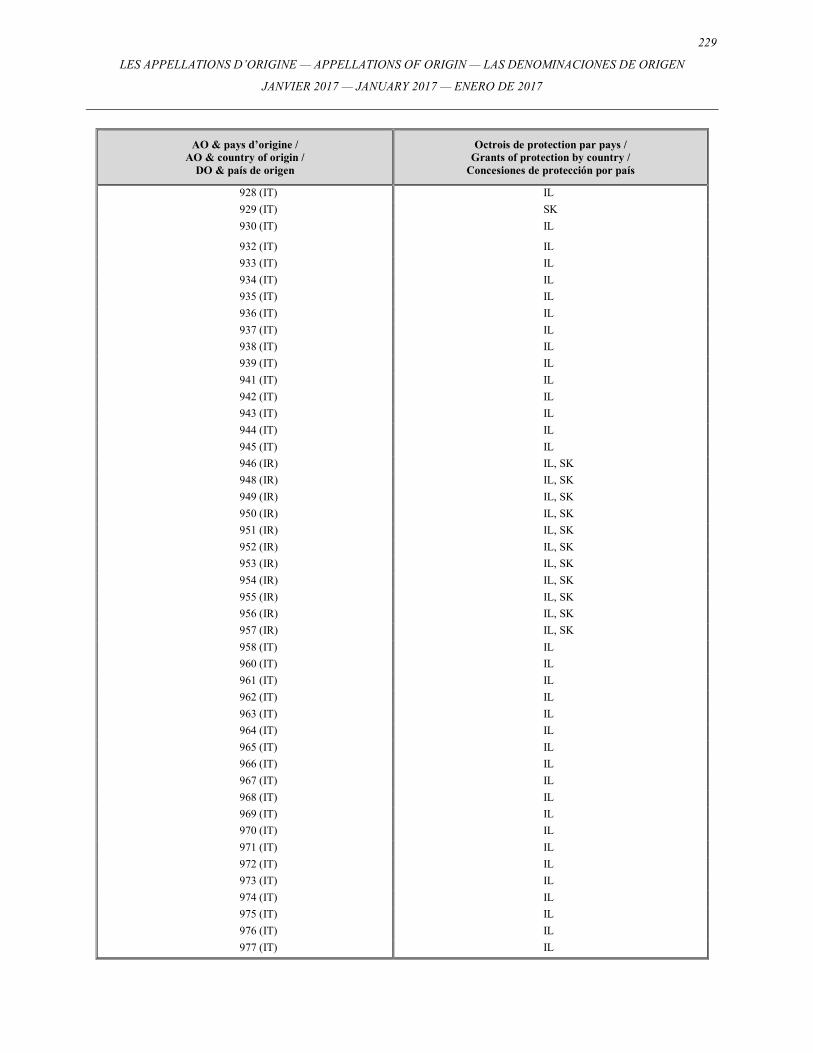
229
LES APPELLATIONS D’ORIGINE — APPELLATIONS OF ORIGIN — LAS DENOMINACIONES DE ORIGEN
JANVIER 2017 — JANUARY 2017 — ENERO DE 2017
AO & pays d’origine / AO & country of origin /
DO & país de origen
Octrois de protection par pays / Grants of protection by country /
Concesiones de protección por país
928 (IT) IL
929 (IT) SK
930 (IT) IL
932 (IT) IL
933 (IT) IL
934 (IT) IL
935 (IT) IL
936 (IT) IL
937 (IT) IL
938 (IT) IL
939 (IT) IL
941 (IT) IL
942 (IT) IL
943 (IT) IL
944 (IT) IL
945 (IT) IL
946 (IR) IL, SK
948 (IR) IL, SK
949 (IR) IL, SK
950 (IR) IL, SK
951 (IR) IL, SK
952 (IR) IL, SK
953 (IR) IL, SK
954 (IR) IL, SK
955 (IR) IL, SK
956 (IR) IL, SK
957 (IR) IL, SK
958 (IT) IL
960 (IT) IL
961 (IT) IL
962 (IT) IL
963 (IT) IL
964 (IT) IL
965 (IT) IL
966 (IT) IL
967 (IT) IL
968 (IT) IL
969 (IT) IL
970 (IT) IL
971 (IT) IL
972 (IT) IL
973 (IT) IL
974 (IT) IL
975 (IT) IL
976 (IT) IL
977 (IT) IL
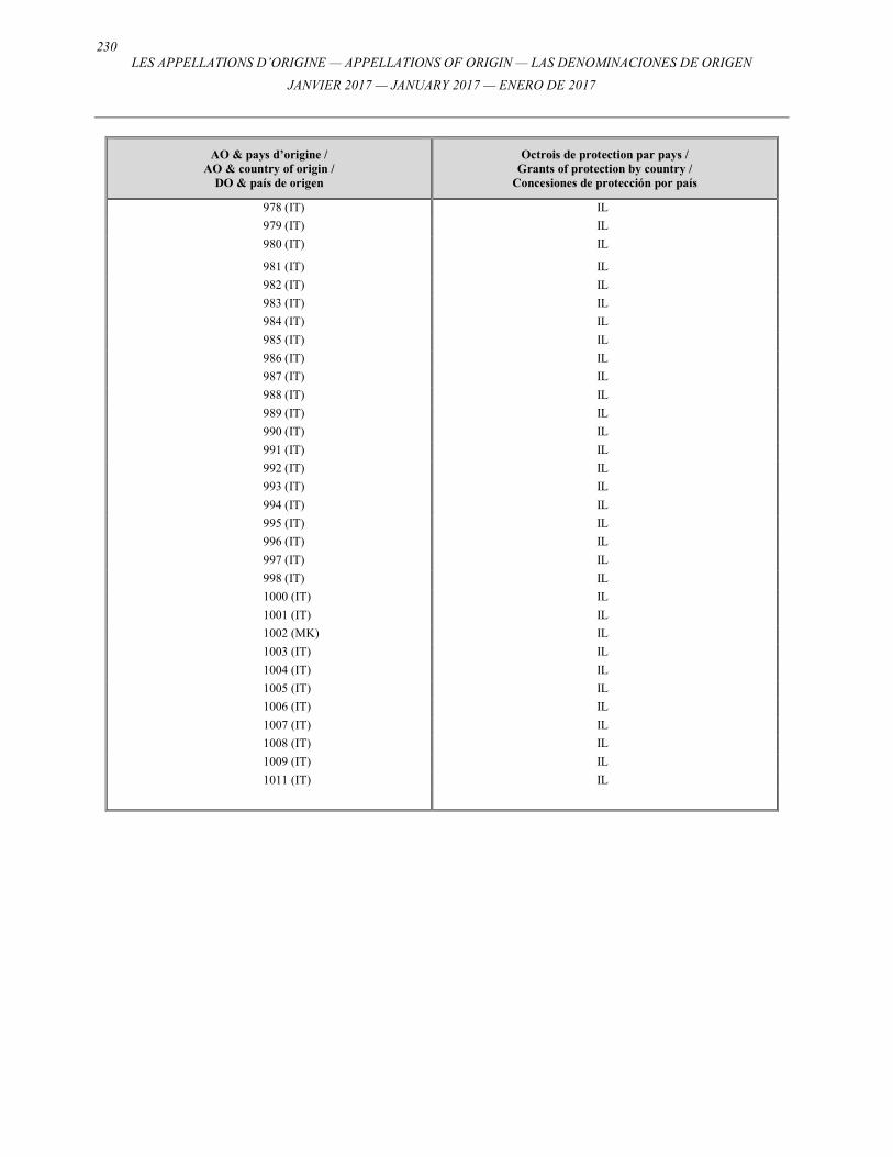
230 LES APPELLATIONS D’ORIGINE — APPELLATIONS OF ORIGIN — LAS DENOMINACIONES DE ORIGEN
JANVIER 2017 — JANUARY 2017 — ENERO DE 2017
AO & pays d’origine / AO & country of origin /
DO & país de origen
Octrois de protection par pays / Grants of protection by country /
Concesiones de protección por país
978 (IT) IL
979 (IT) IL
980 (IT) IL
981 (IT) IL
982 (IT) IL
983 (IT) IL
984 (IT) IL
985 (IT) IL
986 (IT) IL
987 (IT) IL
988 (IT) IL
989 (IT) IL
990 (IT) IL
991 (IT) IL
992 (IT) IL
993 (IT) IL
994 (IT) IL
995 (IT) IL
996 (IT) IL
997 (IT) IL
998 (IT) IL
1000 (IT) IL
1001 (IT) IL
1002 (MK) IL
1003 (IT) IL
1004 (IT) IL
1005 (IT) IL
1006 (IT) IL
1007 (IT) IL
1008 (IT) IL
1009 (IT) IL
1011 (IT) IL
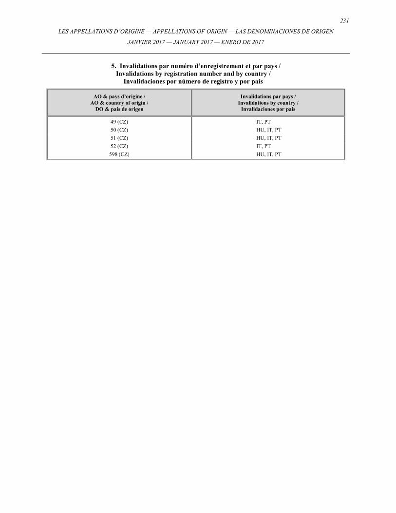
231
LES APPELLATIONS D’ORIGINE — APPELLATIONS OF ORIGIN — LAS DENOMINACIONES DE ORIGEN
JANVIER 2017 — JANUARY 2017 — ENERO DE 2017
5. Invalidations par numéro d’enregistrement et par pays / Invalidations by registration number and by country /
Invalidaciones por número de registro y por país
AO & pays d’origine / AO & country of origin /
DO & país de origen
Invalidations par pays / Invalidations by country /
Invalidaciones por país
49 (CZ) IT, PT
50 (CZ) HU, IT, PT
51 (CZ) HU, IT, PT
52 (CZ) IT, PT
598 (CZ) HU, IT, PT
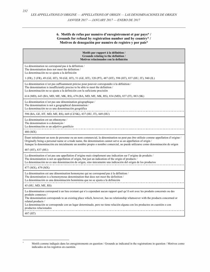
232 LES APPELLATIONS D’ORIGINE — APPELLATIONS OF ORIGIN — LAS DENOMINACIONES DE ORIGEN
JANVIER 2017 — JANUARY 2017 — ENERO DE 2017
6. Motifs de refus par numéro d’enregistrement et par pays* / Grounds for refusal by registration number and by country* /
Motivos de denegación por numéro de registro y por país*
Motifs par rapport à la définition / Grounds relating to the definition /
Motivos relacionados con la definición
La dénomination ne correspond pas à la définition / The denomination does not meet the definition / La denominación no se ajusta a la definición
1 (FR), 2 (FR), 49 (GE, HT), 50 (GE, HT), 51 (GE, HT), 320 (PT), 487 (HT), 598 (HT), 837 (HU, IT), 940 (IL)
La dénomination n’est pas suffisamment précise pour pouvoir correspondre à la définition / The denomination is insufficiently precise to be able to meet the definition / La denominación no se ajusta a la definición con la suficiente precisión
614 (MD), 643 (BA, MD, ME, MK, RS), 678 (BA, MD, ME, MK, RS), 834 (MD), 837 (IT), 883 (SK)
La dénomination n’est pas une dénomination géographique / The denomination is not a geographical denomination / La denominación no es una denominación geográfica
598 (BA, GE, HT, MD, ME, RS), 669 (CZ/SK), 837 (HU, IT), 849 (HU)
La dénomination est un ethnonyme / The denomination is a demonym / La denominación es un adjetivo gentilicio
480 (MX)
Étant initialement un nom de personne ou un nom commercial, la dénomination ne peut pas être utilisée comme appellation d’origine / Originally being a personal name or a trade name, the denomination cannot serve as an appellation of origin / Aunque la denominación era inicialmente un nombre propio o nombre comercial, no puede utilizarse como denominación de origen
487 (HT), 837 (HU)
La dénomination n’est pas une appellation d’origine mais simplement une indication sur l’origine de produits / The denomination is not an appellation of origin, but just an indication of the origin of products / La denominación no es una denominación de origen, sino únicamente una indicación del origen de los productos
477 (MX), 479 (MX)
La dénomination est une dénomination homonyme qui ne correspond pas à la définition / The denomination is a homonymous denomination that does not meet the definition / La denominación es una denominación homónima que no se ajusta a la definición
45 (HU, MD, ME, RS)
La dénomination correspond à un lieu existant qui n’a cependant aucun rapport quel qu’il soit avec les produits concernés ou des produits connexes / The denomination corresponds to an existing place which, however, has no relationship whatsoever with the products concerned or related products / La denominación se corresponde con un lugar determinado, pero no tiene relación alguna con los productos en cuestión o con productos relacionados
487 (HT)
* Motifs comme indiqués dans les enregistrements en question / Grounds as indicated in the registrations in question / Motivos como
indicados en los registros en cuestión.
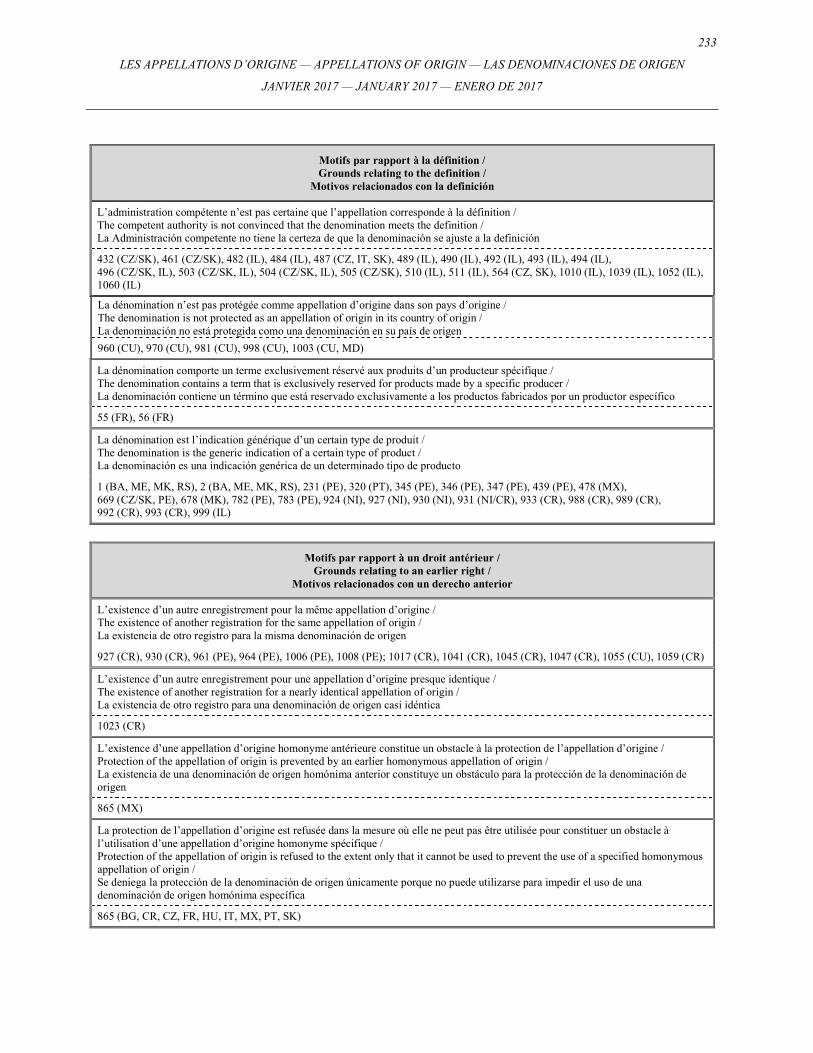
233
LES APPELLATIONS D’ORIGINE — APPELLATIONS OF ORIGIN — LAS DENOMINACIONES DE ORIGEN
JANVIER 2017 — JANUARY 2017 — ENERO DE 2017
Motifs par rapport à la définition / Grounds relating to the definition /
Motivos relacionados con la definición
L’administration compétente n’est pas certaine que l’appellation corresponde à la définition / The competent authority is not convinced that the denomination meets the definition / La Administración competente no tiene la certeza de que la denominación se ajuste a la definición
432 (CZ/SK), 461 (CZ/SK), 482 (IL), 484 (IL), 487 (CZ, IT, SK), 489 (IL), 490 (IL), 492 (IL), 493 (IL), 494 (IL), 496 (CZ/SK, IL), 503 (CZ/SK, IL), 504 (CZ/SK, IL), 505 (CZ/SK), 510 (IL), 511 (IL), 564 (CZ, SK), 1010 (IL), 1039 (IL), 1052 (IL), 1060 (IL)
La dénomination n’est pas protégée comme appellation d’origine dans son pays d’origine / The denomination is not protected as an appellation of origin in its country of origin / La denominación no está protegida como una denominación en su país de origen
960 (CU), 970 (CU), 981 (CU), 998 (CU), 1003 (CU, MD)
La dénomination comporte un terme exclusivement réservé aux produits d’un producteur spécifique / The denomination contains a term that is exclusively reserved for products made by a specific producer / La denominación contiene un término que está reservado exclusivamente a los productos fabricados por un productor específico
55 (FR), 56 (FR)
La dénomination est l’indication générique d’un certain type de produit / The denomination is the generic indication of a certain type of product / La denominación es una indicación genérica de un determinado tipo de producto
1 (BA, ME, MK, RS), 2 (BA, ME, MK, RS), 231 (PE), 320 (PT), 345 (PE), 346 (PE), 347 (PE), 439 (PE), 478 (MX), 669 (CZ/SK, PE), 678 (MK), 782 (PE), 783 (PE), 924 (NI), 927 (NI), 930 (NI), 931 (NI/CR), 933 (CR), 988 (CR), 989 (CR), 992 (CR), 993 (CR), 999 (IL)
Motifs par rapport à un droit antérieur / Grounds relating to an earlier right /
Motivos relacionados con un derecho anterior
L’existence d’un autre enregistrement pour la même appellation d’origine / The existence of another registration for the same appellation of origin / La existencia de otro registro para la misma denominación de origen
927 (CR), 930 (CR), 961 (PE), 964 (PE), 1006 (PE), 1008 (PE); 1017 (CR), 1041 (CR), 1045 (CR), 1047 (CR), 1055 (CU), 1059 (CR)
L’existence d’un autre enregistrement pour une appellation d’origine presque identique / The existence of another registration for a nearly identical appellation of origin / La existencia de otro registro para una denominación de origen casi idéntica
1023 (CR)
L’existence d’une appellation d’origine homonyme antérieure constitue un obstacle à la protection de l’appellation d’origine / Protection of the appellation of origin is prevented by an earlier homonymous appellation of origin / La existencia de una denominación de origen homónima anterior constituye un obstáculo para la protección de la denominación de origen
865 (MX)
La protection de l’appellation d’origine est refusée dans la mesure où elle ne peut pas être utilisée pour constituer un obstacle à l’utilisation d’une appellation d’origine homonyme spécifique / Protection of the appellation of origin is refused to the extent only that it cannot be used to prevent the use of a specified homonymous appellation of origin / Se deniega la protección de la denominación de origen únicamente porque no puede utilizarse para impedir el uso de una denominación de origen homónima específica
865 (BG, CR, CZ, FR, HU, IT, MX, PT, SK)
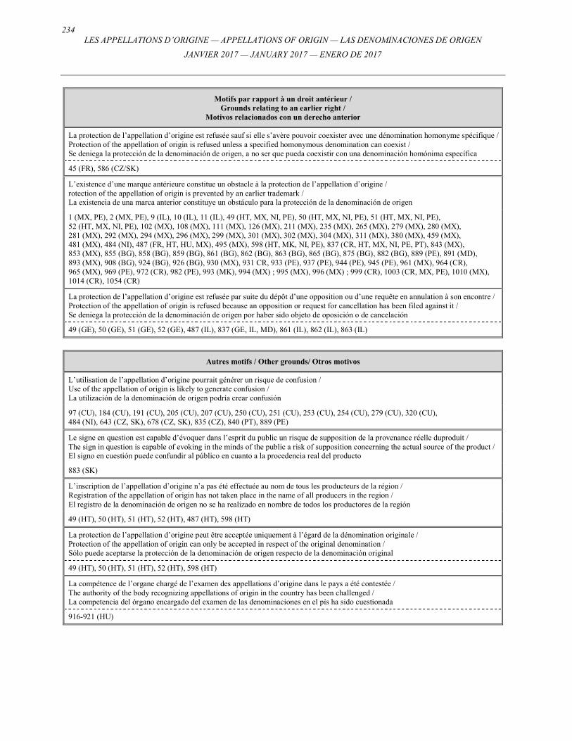
234 LES APPELLATIONS D’ORIGINE — APPELLATIONS OF ORIGIN — LAS DENOMINACIONES DE ORIGEN
JANVIER 2017 — JANUARY 2017 — ENERO DE 2017
Motifs par rapport à un droit antérieur / Grounds relating to an earlier right /
Motivos relacionados con un derecho anterior
La protection de l’appellation d’origine est refusée sauf si elle s’avère pouvoir coexister avec une dénomination homonyme spécifique / Protection of the appellation of origin is refused unless a specified homonymous denomination can coexist / Se deniega la protección de la denominación de origen, a no ser que pueda coexistir con una denominación homónima específica
45 (FR), 586 (CZ/SK)
L’existence d’une marque antérieure constitue un obstacle à la protection de l’appellation d’origine / rotection of the appellation of origin is prevented by an earlier trademark / La existencia de una marca anterior constituye un obstáculo para la protección de la denominación de origen
1 (MX, PE), 2 (MX, PE), 9 (IL), 10 (IL), 11 (IL), 49 (HT, MX, NI, PE), 50 (HT, MX, NI, PE), 51 (HT, MX, NI, PE), 52 (HT, MX, NI, PE), 102 (MX), 108 (MX), 111 (MX), 126 (MX), 211 (MX), 235 (MX), 265 (MX), 279 (MX), 280 (MX), 281 (MX), 292 (MX), 294 (MX), 296 (MX), 299 (MX), 301 (MX), 302 (MX), 304 (MX), 311 (MX), 380 (MX), 459 (MX), 481 (MX), 484 (NI), 487 (FR, HT, HU, MX), 495 (MX), 598 (HT, MK, NI, PE), 837 (CR, HT, MX, NI, PE, PT), 843 (MX), 853 (MX), 855 (BG), 858 (BG), 859 (BG), 861 (BG), 862 (BG), 863 (BG), 865 (BG), 875 (BG), 882 (BG), 889 (PE), 891 (MD), 893 (MX), 908 (BG), 924 (BG), 926 (BG), 930 (MX), 931 CR, 933 (PE), 937 (PE), 944 (PE), 945 (PE), 961 (MX), 964 (CR), 965 (MX), 969 (PE), 972 (CR), 982 (PE), 993 (MK), 994 (MX) ; 995 (MX), 996 (MX) ; 999 (CR), 1003 (CR, MX, PE), 1010 (MX), 1014 (CR), 1054 (CR)
La protection de l’appellation d’origine est refusée par suite du dépôt d’une opposition ou d’une requête en annulation à son encontre / Protection of the appellation of origin is refused because an opposition or request for cancellation has been filed against it / Se deniega la protección de la denominación de origen por haber sido objeto de oposición o de cancelación
49 (GE), 50 (GE), 51 (GE), 52 (GE), 487 (IL), 837 (GE, IL, MD), 861 (IL), 862 (IL), 863 (IL)
Autres motifs / Other grounds/ Otros motivos
L’utilisation de l’appellation d’origine pourrait générer un risque de confusion / Use of the appellation of origin is likely to generate confusion / La utilización de la denominación de origen podría crear confusión
97 (CU), 184 (CU), 191 (CU), 205 (CU), 207 (CU), 250 (CU), 251 (CU), 253 (CU), 254 (CU), 279 (CU), 320 (CU), 484 (NI), 643 (CZ, SK), 678 (CZ, SK), 835 (CZ), 840 (PT), 889 (PE)
Le signe en question est capable d’évoquer dans l’esprit du public un risque de supposition de la provenance réelle duproduit / The sign in question is capable of evoking in the minds of the public a risk of supposition concerning the actual source of the product / El signo en cuestión puede confundir al público en cuanto a la procedencia real del producto
883 (SK)
L’inscription de l’appellation d’origine n’a pas été effectuée au nom de tous les producteurs de la région / Registration of the appellation of origin has not taken place in the name of all producers in the region / El registro de la denominación de origen no se ha realizado en nombre de todos los productores de la región
49 (HT), 50 (HT), 51 (HT), 52 (HT), 487 (HT), 598 (HT)
La protection de l’appellation d’origine peut être acceptée uniquement à l’égard de la dénomination originale / Protection of the appellation of origin can only be accepted in respect of the original denomination / Sólo puede aceptarse la protección de la denominación de origen respecto de la denominación original
49 (HT), 50 (HT), 51 (HT), 52 (HT), 598 (HT)
La compétence de l’organe chargé de l’examen des appellations d’origine dans le pays a été contestée / The authority of the body recognizing appellations of origin in the country has been challenged / La competencia del órgano encargado del examen de las denominaciones en el pís ha sido cuestionada
916-921 (HU)
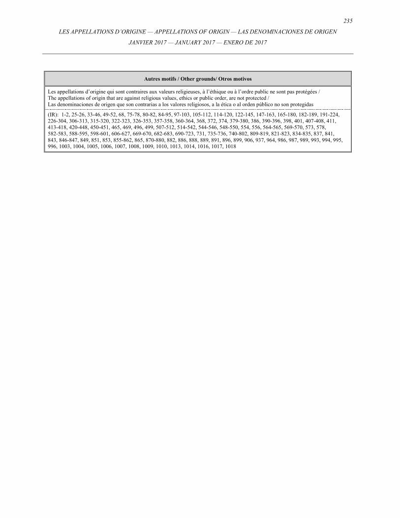
235
LES APPELLATIONS D’ORIGINE — APPELLATIONS OF ORIGIN — LAS DENOMINACIONES DE ORIGEN
JANVIER 2017 — JANUARY 2017 — ENERO DE 2017
Autres motifs / Other grounds/ Otros motivos
Les appellations d’origine qui sont contraires aux valeurs religieuses, à l’éthique ou à l’ordre public ne sont pas protégées / The appellations of origin that are against religious values, ethics or public order, are not protected / Las denominaciones de origen que son contrarias a los valores religiosos, a la ética o al orden público no son protegidas
(IR): 1-2, 25-26, 33-46, 49-52, 68, 75-78, 80-82, 84-95, 97-103, 105-112, 114-120, 122-145, 147-163, 165-180, 182-189, 191-224, 226-304, 306-313, 315-320, 322-323, 326-353, 357-358, 360-364, 368, 372, 374, 379-380, 386, 390-396, 398, 401, 407-408, 411, 413-418, 420-448, 450-451, 465, 469, 496, 499, 507-512, 514-542, 544-546, 548-550, 554, 556, 564-565, 569-570, 573, 578, 582-583, 588-595, 598-601, 606-627, 669-670, 682-683, 690-723, 731, 735-736, 740-802, 809-819, 821-823, 834-835, 837, 841, 843, 846-847, 849, 851, 853, 855-862, 865, 870-880, 882, 886, 888, 889, 891, 896, 899, 906, 937, 964, 986, 987, 989, 993, 994, 995, 996, 1003, 1004, 1005, 1006, 1007, 1008, 1009, 1010, 1013, 1014, 1016, 1017, 1018
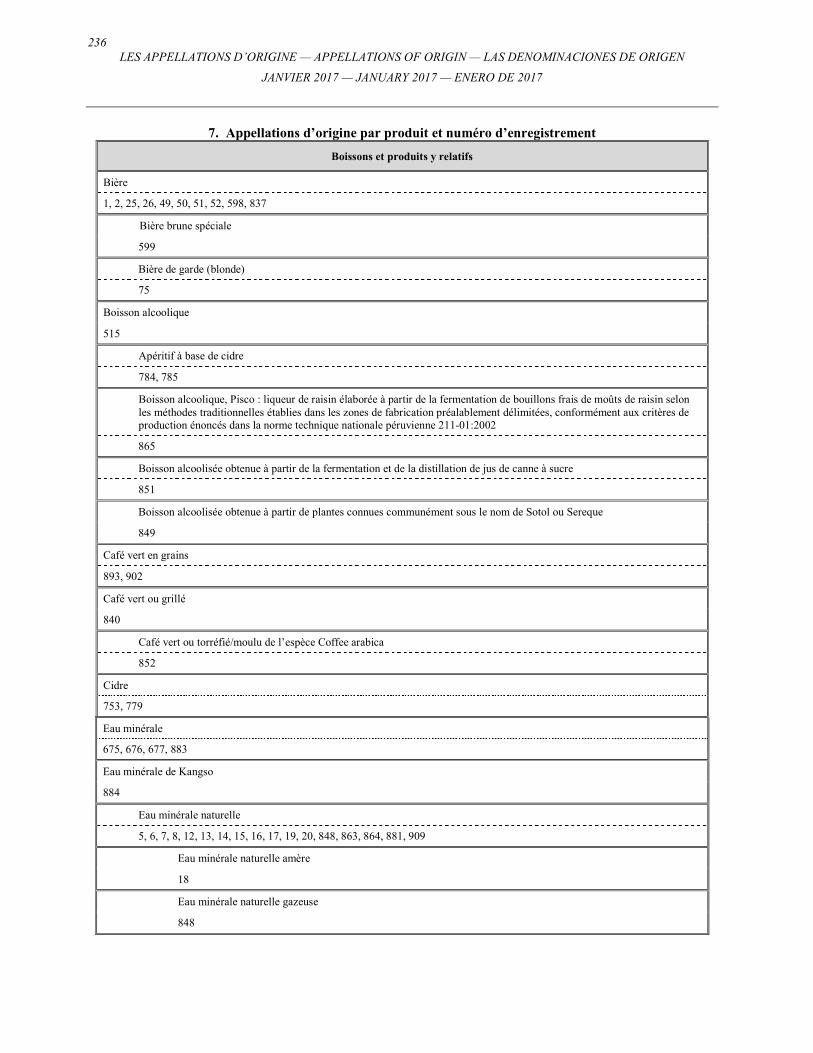
236 LES APPELLATIONS D’ORIGINE — APPELLATIONS OF ORIGIN — LAS DENOMINACIONES DE ORIGEN
JANVIER 2017 — JANUARY 2017 — ENERO DE 2017
7. Appellations d’origine par produit et numéro d’enregistrement
Boissons et produits y relatifs
Bière
1, 2, 25, 26, 49, 50, 51, 52, 598, 837
Bière brune spéciale
599
Bière de garde (blonde)
75
Boisson alcoolique
515
Apéritif à base de cidre
784, 785
Boisson alcoolique, Pisco : liqueur de raisin élaborée à partir de la fermentation de bouillons frais de moûts de raisin selon les méthodes traditionnelles établies dans les zones de fabrication préalablement délimitées, conformément aux critères de production énoncés dans la norme technique nationale péruvienne 211-01:2002
865
Boisson alcoolisée obtenue à partir de la fermentation et de la distillation de jus de canne à sucre
851
Boisson alcoolisée obtenue à partir de plantes connues communément sous le nom de Sotol ou Sereque
849
Café vert en grains
893, 902
Café vert ou grillé
840
Café vert ou torréfié/moulu de l’espèce Coffee arabica
852
Cidre
753, 779
Eau minérale
675, 676, 677, 883
Eau minérale de Kangso
884
Eau minérale naturelle
5, 6, 7, 8, 12, 13, 14, 15, 16, 17, 19, 20, 848, 863, 864, 881, 909
Eau minérale naturelle amère
18
Eau minérale naturelle gazeuse
848
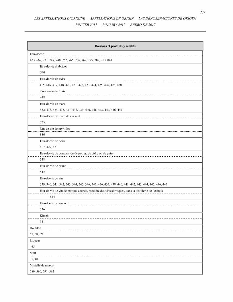
237
LES APPELLATIONS D’ORIGINE — APPELLATIONS OF ORIGIN — LAS DENOMINACIONES DE ORIGEN
JANVIER 2017 — JANUARY 2017 — ENERO DE 2017
Boissons et produits y relatifs
348
Eau-de-vie de prune
542
Eau-de-vie de vin
339, 340, 341, 342, 343, 344, 345, 346, 347, 436, 437, 438, 440, 441, 442, 443, 444, 445, 446, 447
Eau-de-vie de vin de marque coupée, produite des vins slovaques, dans la distillerie de Pezinok
614
Eau-de-vie de vin vert
736
Kirsch
541
Houblon
57, 58, 59
Liqueur
465
Malt
31, 48
Mistelle de muscat
589, 590, 591, 592
Eau-de-vie
433, 669, 731, 747, 748, 752, 765, 766, 767, 775, 782, 783, 841
Eau-de-vie d’abricot
540
Eau-de-vie de cidre
415, 416, 417, 418, 420, 421, 422, 423, 424, 425, 426, 428, 430
Eau-de-vie de fruits
448
Eau-de-vie de marc
432, 433, 434, 435, 437, 438, 439, 440, 441, 443, 444, 446, 447
Eau-de-vie de marc de vin vert
735
Eau-de-vie de myrtilles
886
Eau-de-vie de poiré
427, 429, 431
Eau-de-vie de pommes ou de poires, de cidre ou de poiré
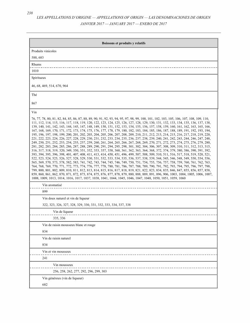
238 LES APPELLATIONS D’ORIGINE — APPELLATIONS OF ORIGIN — LAS DENOMINACIONES DE ORIGEN
JANVIER 2017 — JANUARY 2017 — ENERO DE 2017
Boissons et produits y relatifs
Produits vinicoles
588, 683
Rhums
1010
Spiritueux
46, 68, 469, 514, 670, 964
Thé
867
Vin
76, 77, 78, 80, 81, 82, 84, 85, 86, 87, 88, 89, 90, 91, 92, 93, 94, 95, 97, 98, 99, 100, 101, 102, 103, 105, 106, 107, 108, 109, 110, 111, 112, 114, 115, 116, 117, 118, 119, 120, 122, 123, 124, 125, 126, 127, 128, 129, 130, 131, 132, 133, 134, 135, 136, 137, 138, 139, 140, 141, 142, 143, 144, 145, 147, 148, 149, 150, 151, 152, 153, 154, 155, 156, 157, 158, 159, 160, 161, 162, 163, 165, 166, 167, 168, 169, 170, 171, 172, 173, 174, 175, 176, 177, 178, 179, 180, 182, 183, 184, 185, 186, 187, 188, 189, 191, 192, 193, 194, 195, 196, 197, 198, 199, 200, 201, 202, 203, 204, 205, 206, 207, 208, 209, 210, 211, 212, 213, 214, 215, 216, 217, 218, 219, 220, 221, 222, 223, 224, 226, 227, 228, 229, 230, 231, 232, 233, 234, 235, 236, 237, 238, 239, 240, 241, 242, 243, 244, 246, 247, 248, 249, 250, 251, 252, 253, 254, 255, 257, 259, 260, 261, 264, 265, 266, 267, 268, 269, 270, 271, 272, 273, 274, 275, 276, 279, 280, 281, 282, 283, 284, 285, 286, 287, 288, 289, 290, 291, 294, 295, 298, 301, 302, 304, 306, 307, 308, 309, 310, 311, 312, 313, 315, 316, 317, 318, 319, 320, 349, 350, 351, 352, 353, 357, 358, 360, 361, 362, 363, 364, 368, 372, 374, 379, 380, 386, 390, 391, 392, 393, 394, 395, 396, 398, 401, 407, 408, 411, 413, 414, 450, 451, 496, 499, 507, 508, 509, 510, 511, 516, 517, 518, 519, 520, 521, 522, 523, 524, 525, 526, 527, 528, 529, 530, 531, 532, 533, 534, 535, 536, 537, 538, 539, 544, 545, 546, 548, 549, 550, 554, 556, 565, 569, 570, 573, 578, 582, 583, 741, 742, 743, 744, 745, 746, 749, 750, 751, 754, 755, 756, 757, 758, 759, 760, 761, 762, 763, 764, 768, 769, 770, 771, 772, 773, 774, 776, 777, 778, 780, 781, 786, 787, 788, 789, 790, 791, 792, 793, 794, 795, 796, 797, 798, 799, 800, 801, 802, 809, 810, 811, 812, 813, 814, 815, 816, 817, 818, 819, 821, 822, 823, 834, 835, 846, 847, 855, 856, 857, 858, 859, 860, 861, 862, 870, 871, 872, 873, 874, 875, 876, 877, 878, 879, 880, 888, 889, 891, 896, 906, 1003, 1004, 1005, 1006, 1007, 1008, 1009, 1013, 1014, 1016, 1017, 1037, 1038, 1041, 1044, 1045, 1046, 1047, 1048, 1050, 1051, 1059, 1060
Vin aromatisé
899
Vin doux naturel et vin de liqueur
322, 323, 326, 327, 328, 329, 330, 331, 332, 333, 334, 337, 338
Vin de liqueur
335, 336
Vin de raisin mousseux blanc et rouge
834
Vin de raisin naturel
834
Vin et vin mousseux
241
Vin mousseux
256, 258, 262, 277, 292, 296, 299, 303
Vin généreux (vin de liqueur)
682
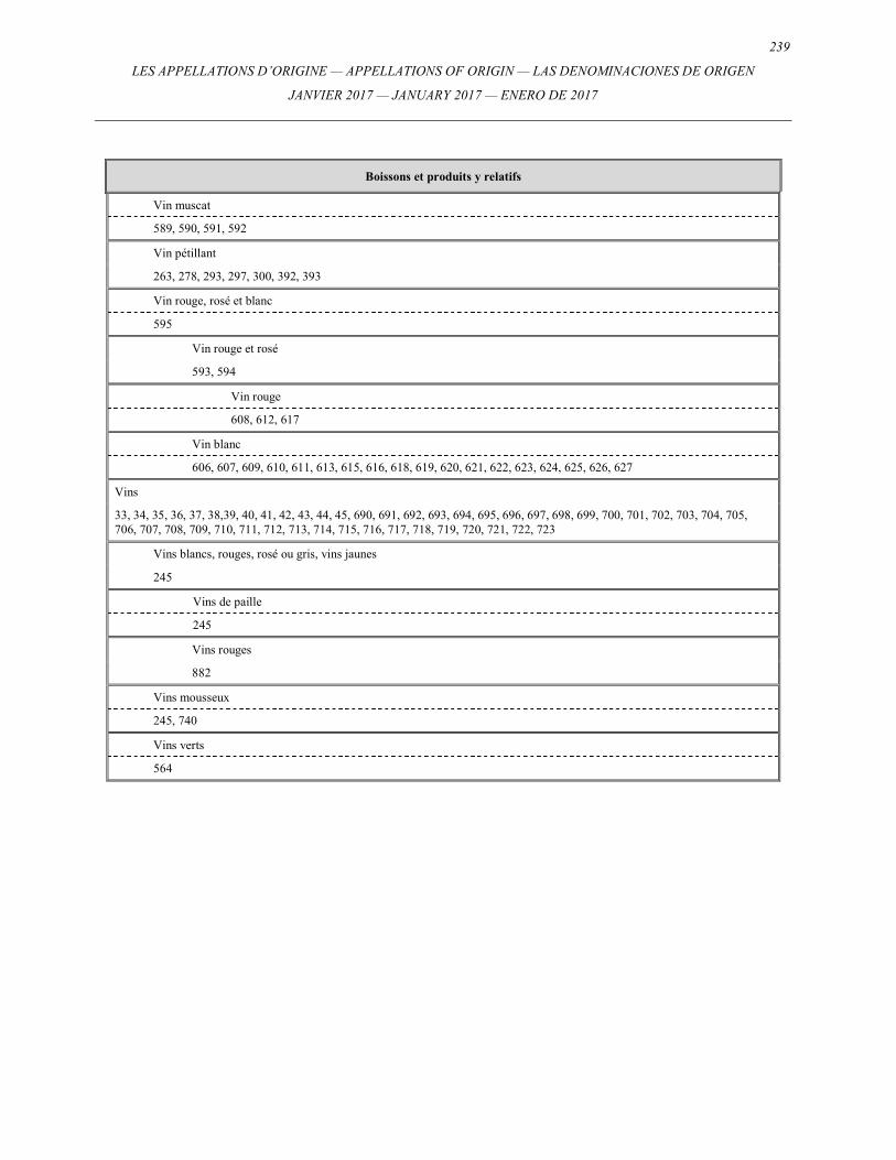
239
LES APPELLATIONS D’ORIGINE — APPELLATIONS OF ORIGIN — LAS DENOMINACIONES DE ORIGEN
JANVIER 2017 — JANUARY 2017 — ENERO DE 2017
Boissons et produits y relatifs
Vin muscat
589, 590, 591, 592
Vin pétillant
263, 278, 293, 297, 300, 392, 393
Vin rouge, rosé et blanc
595
Vin rouge et rosé
593, 594
Vin rouge
608, 612, 617
Vin blanc
606, 607, 609, 610, 611, 613, 615, 616, 618, 619, 620, 621, 622, 623, 624, 625, 626, 627
Vins
33, 34, 35, 36, 37, 38,39, 40, 41, 42, 43, 44, 45, 690, 691, 692, 693, 694, 695, 696, 697, 698, 699, 700, 701, 702, 703, 704, 705, 706, 707, 708, 709, 710, 711, 712, 713, 714, 715, 716, 717, 718, 719, 720, 721, 722, 723
Vins blancs, rouges, rosé ou gris, vins jaunes
245
Vins de paille
245
Vins rouges
882
Vins mousseux
245, 740
Vins verts
564
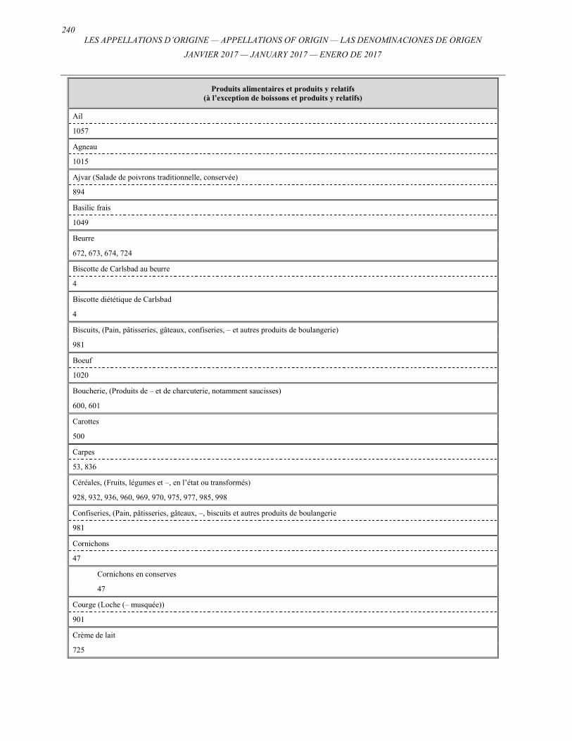
240 LES APPELLATIONS D’ORIGINE — APPELLATIONS OF ORIGIN — LAS DENOMINACIONES DE ORIGEN
JANVIER 2017 — JANUARY 2017 — ENERO DE 2017
Produits alimentaires et produits y relatifs (à l’exception de boissons et produits y relatifs)
Ail
1057
Agneau
1015
Ajvar (Salade de poivrons traditionnelle, conservée)
894
Basilic frais
1049
Beurre
672, 673, 674, 724
Biscotte de Carlsbad au beurre
4
Biscotte diététique de Carlsbad
4
Biscuits, (Pain, pâtisseries, gâteaux, confiseries, – et autres produits de boulangerie)
981
Boeuf
1020
Boucherie, (Produits de – et de charcuterie, notamment saucisses)
600, 601
Carottes
500
Carpes
53, 836
Céréales, (Fruits, légumes et –, en l’état ou transformés)
928, 932, 936, 960, 969, 970, 975, 977, 985, 998
Confiseries, (Pain, pâtisseries, gâteaux, –, biscuits et autres produits de boulangerie
981
Cornichons
47
Cornichons en conserves
47
Courge (Loche (– musquée))
901
Crème de lait
725
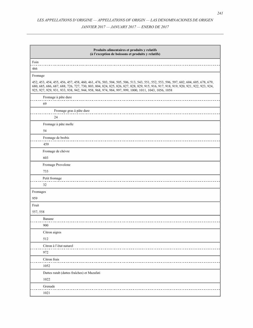
241
LES APPELLATIONS D’ORIGINE — APPELLATIONS OF ORIGIN — LAS DENOMINACIONES DE ORIGEN
JANVIER 2017 — JANUARY 2017 — ENERO DE 2017
Produits alimentaires et produits y relatifs (à l’exception de boissons et produits y relatifs)
Foin
466
Fromage
452, 453, 454, 455, 456, 457, 458, 460, 461, 476, 503, 504, 505, 506, 513, 543, 551, 552, 553, 596, 597, 602, 604, 605, 678, 679, 680, 685, 686, 687, 688, 726, 727, 730, 803, 804, 824, 825, 826, 827, 828, 829, 915, 916, 917, 918, 919, 920, 921, 922, 923, 924, 925, 927, 929, 931, 933, 938, 942, 944, 958, 968, 974, 984, 997, 999, 1000, 1011, 1043, 1056, 1058
Fromage à pâte dure
69
Fromage gras à pâte dure
24
Fromage à pâte molle
54
Fromage de brebis
459
Fromage de chèvre
603
Fromage Provolone
733
Petit fromage
32
Fromages
959
Fruit
557, 558
Banane
900
Citron aigres
512
Citron à l’état naturel
972
Citron frais
1052
Dattes rutab (dattes fraîches) et Mazafati
1022
Grenade
1021
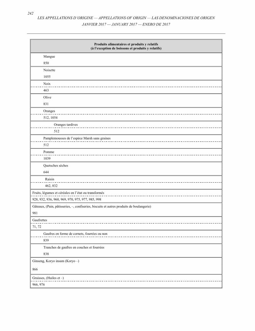
242 LES APPELLATIONS D’ORIGINE — APPELLATIONS OF ORIGIN — LAS DENOMINACIONES DE ORIGEN
JANVIER 2017 — JANUARY 2017 — ENERO DE 2017
Produits alimentaires et produits y relatifs (à l’exception de boissons et produits y relatifs)
Mangue
850
Noisette
1055
Noix
463
Olive
831
Oranges
512, 1054
Oranges tardives
512
Pamplemousses de l’espèce Marsh sans graines
512
Pomme
1039
Quetsches sèches
644
Raisin
462, 832
Fruits, légumes et céréales en l’état ou transformés
928, 932, 936, 960, 969, 970, 975, 977, 985, 998
Gâteaux, (Pain, pâtisseries, –, confiseries, biscuits et autres produits de boulangerie)
981
Gaufrettes
71, 72
Gaufres en forme de cornets, fourrées ou non
839
Tranches de gaufres en couches et fourrées
838
Ginseng, Koryo insam (Koryo –)
866
Graisses, (Huiles et –)
966, 976
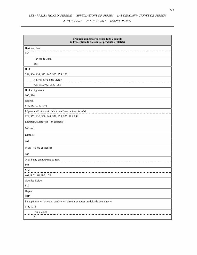
243
LES APPELLATIONS D’ORIGINE — APPELLATIONS OF ORIGIN — LAS DENOMINACIONES DE ORIGEN
JANVIER 2017 — JANUARY 2017 — ENERO DE 2017
Produits alimentaires et produits y relatifs (à l’exception de boissons et produits y relatifs)
Haricots blanc
830
Haricot de Lima
885
Huile
559, 806, 939, 943, 962, 963, 973, 1001
Huile d’olive extra vierge
978, 980, 982, 983, 1053
Huiles et graisses
966, 976
Jambon
843, 853, 937, 1040
Légumes, (Fruits, – et céréales en l’état ou transformés)
928, 932, 936, 960, 969, 970, 975, 977, 985, 998
Légumes, (Salade de – en conserve)
643, 671
Lentilles
464
Maca (fraîche et séchée)
903
Maïs blanc géant (Paraqay Sara)
868
Miel
467, 807, 808, 892, 895
Nouilles froides
887
Oignon
1019
Pain, pâtisseries, gâteaux, confiseries, biscuits et autres produits de boulangerie
981, 1012
Pain d’épice
70
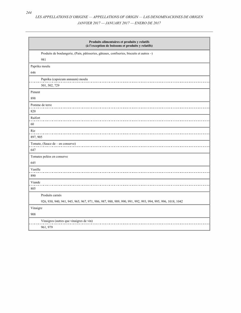
244 LES APPELLATIONS D’ORIGINE — APPELLATIONS OF ORIGIN — LAS DENOMINACIONES DE ORIGEN
JANVIER 2017 — JANUARY 2017 — ENERO DE 2017
Produits alimentaires et produits y relatifs (à l’exception de boissons et produits y relatifs)
Produits de boulangerie, (Pain, pâtisseries, gâteaux, confiseries, biscuits et autres –)
981
Paprika moulu
646
Paprika (capsicum annuum) moulu
501, 502, 729
Piment
898
Pomme de terre
820
Raifort
60
Riz
897, 905
Tomate, (Sauce de – en conserve)
647
Tomates pelées en conserve
645
Vanille
890
Viande
805
Produits carnés
926, 930, 940, 941, 945, 965, 967, 971, 986, 987, 988, 989, 990, 991, 992, 993, 994, 995, 996, 1018, 1042
Vinaigre
908
Vinaigres (autres que vinaigres de vin)
961, 979
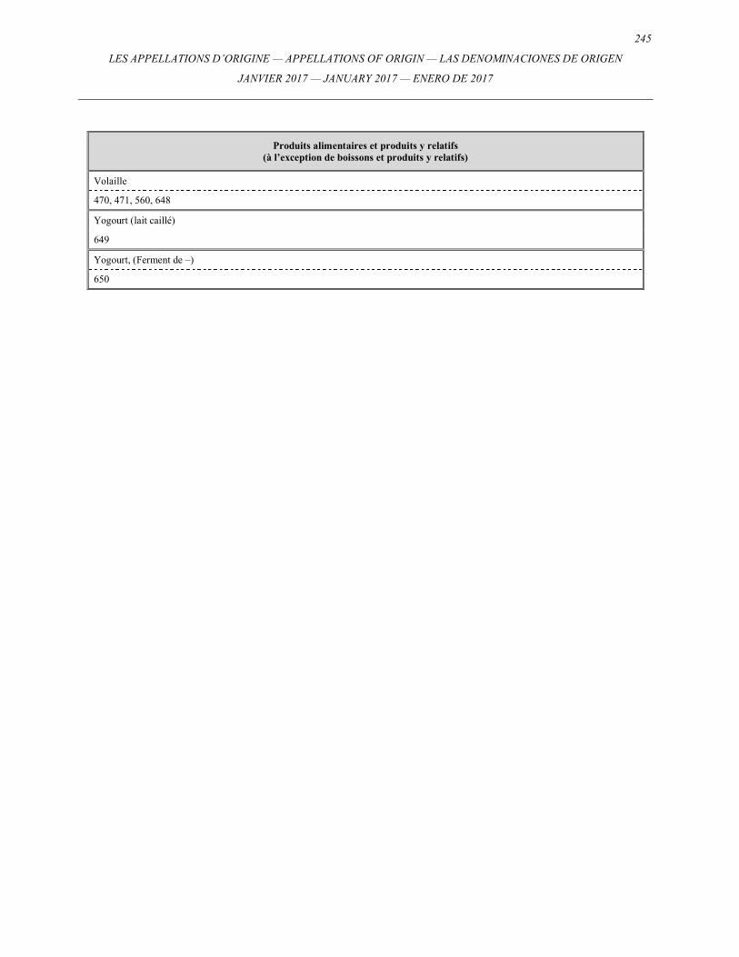
245
LES APPELLATIONS D’ORIGINE — APPELLATIONS OF ORIGIN — LAS DENOMINACIONES DE ORIGEN
JANVIER 2017 — JANUARY 2017 — ENERO DE 2017
Produits alimentaires et produits y relatifs (à l’exception de boissons et produits y relatifs)
Volaille
470, 471, 560, 648
Yogourt (lait caillé)
649
Yogourt, (Ferment de –)
650
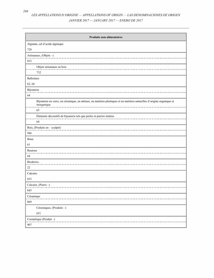
246 LES APPELLATIONS D’ORIGINE — APPELLATIONS OF ORIGIN — LAS DENOMINACIONES DE ORIGEN
JANVIER 2017 — JANUARY 2017 — ENERO DE 2017
Produits non-alimentaires
Alginate, sel d’acide alginique
728
Artisanaux, (Objets –)
833
Objets artisanaux en bois
732
Ballotines
62, 64
Bijouterie
64
Bijouterie en verre, en céramique, en métaux, en matières plastiques et en matières naturelles d’origine organique et inorganique
65
Éléments décoratifs de bijouterie tels que perles et pierres imitées
64
Bois, (Produits en – sculpté)
946
Boue
61
Boutons
64
Broderies
22
Calcaire
653
Calcaire, (Pierre –)
845
Céramique
869
Céramiques, (Produits –)
651
Cosmétique (Produit –)
907
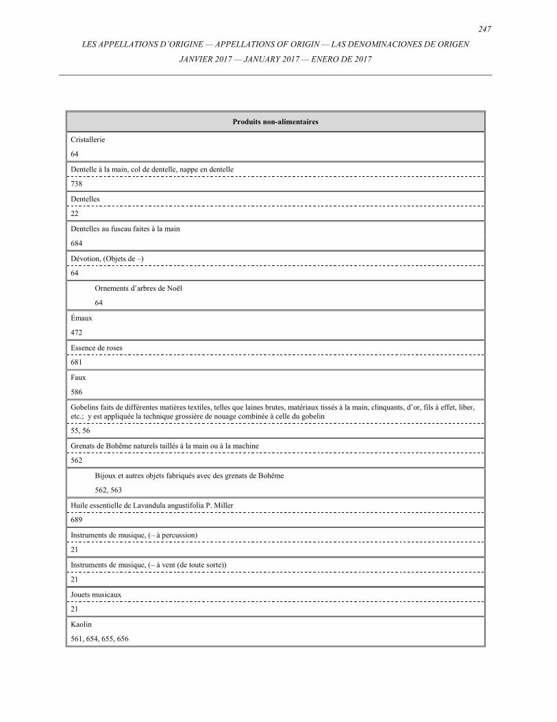
247
LES APPELLATIONS D’ORIGINE — APPELLATIONS OF ORIGIN — LAS DENOMINACIONES DE ORIGEN
JANVIER 2017 — JANUARY 2017 — ENERO DE 2017
Produits non-alimentaires
Cristallerie
64
Dentelle à la main, col de dentelle, nappe en dentelle
738
Dentelles
22
Dentelles au fuseau faites à la main
684
Dévotion, (Objets de –)
64
Ornements d’arbres de Noël
64
Émaux
472
Essence de roses
681
Faux
586
Gobelins faits de différentes matières textiles, telles que laines brutes, matériaux tissés à la main, clinquants, d’or, fils à effet, liber, etc.; y est appliquée la technique grossière de nouage combinée à celle du gobelin
55, 56
Grenats de Bohême naturels taillés à la main ou à la machine
562
Bijoux et autres objets fabriqués avec des grenats de Bohême
562, 563
Huile essentielle de Lavandula angustifolia P. Miller
689
Instruments de musique, (– à percussion)
21
Instruments de musique, (– à vent (de toute sorte))
21
Jouets musicaux
21
Kaolin
561, 654, 655, 656
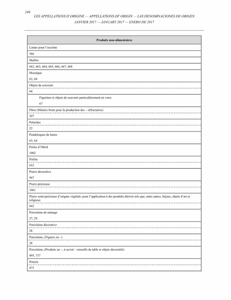
248 LES APPELLATIONS D’ORIGINE — APPELLATIONS OF ORIGIN — LAS DENOMINACIONES DE ORIGEN
JANVIER 2017 — JANUARY 2017 — ENERO DE 2017
Produits non-alimentaires
Lames pour l’escrime
586
Marbre
662, 663, 664, 665, 666, 667, 668
Mosaïque
62, 64
Objets de souvenir
64
Figurines et objets de souvenir particulièrement en verre
67
Pâtes (Matière brute pour la production des – réfractaires)
547
Peluches
22
Pendeloques de lustre
63, 64
Perles d’Ohrid
1002
Perlite
652
Pierre décorative
947
Pierre précieuse
1061
Pierre semi-précieuse d’origine végétale, pour l’application à des produits dérivés tels que, entre autres, bijoux, objets d’art et religieux
842
Porcelaine de ménage
27, 29
Porcelaine décorative
28
Porcelaine, (Figures en –)
28
Porcelaine, (Produits en –, à savoir : vaisselle de table et objets décoratifs)
495, 737
Poterie
475
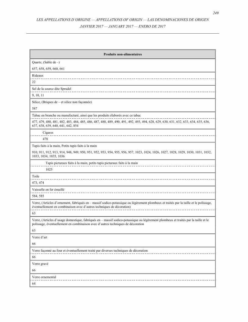
249
LES APPELLATIONS D’ORIGINE — APPELLATIONS OF ORIGIN — LAS DENOMINACIONES DE ORIGEN
JANVIER 2017 — JANUARY 2017 — ENERO DE 2017
Produits non-alimentaires
Quartz, (Sable de –)
657, 658, 659, 660, 661
Rideaux
22
Sel de la source dite Sprudel
9, 10, 11
Silice, (Briques de – et silice non façonnée)
587
Tabac en branche ou manufacturé, ainsi que les produits élaborés avec ce tabac
477, 479, 480, 481, 482, 483, 484, 485, 486, 487, 488, 489, 490, 491, 492, 493, 494, 628, 629, 630, 631, 632, 633, 634, 635, 636, 637, 638, 639, 640, 641, 642, 854
Cigares
478
Tapis faits à la main, Petits tapis faits à la main
910, 911, 912, 913, 914, 948, 949, 950, 951, 952, 953, 954, 955, 956, 957, 1023, 1024, 1026, 1027, 1028, 1029, 1030, 1031, 1032, 1033, 1034, 1035, 1036
Tapis picturaux faits à la main, petits tapis picturaux faits à la main
1025
Toile
473, 474
Vaisselle en fer émaillé
584, 585
Verre, (Articles d’ornement, fabriqués en – massif sodico-potassique ou légèrement plombeux et traités par la taille et le polissage, éventuellement en combinaison avec d’autres techniques de décoration)
63
Verre, (Articles d’usage domestique, fabriqués en – massif sodico-potassique ou légèrement plombeux et traités par la taille et le polissage, éventuellement en combinaison avec d’autres techniques de décoration
63
Verre d’art
66
Verre façonné au four et éventuellement traité par diverses techniques de décoration
66
Verre gravé
66
Verre ornemental
64
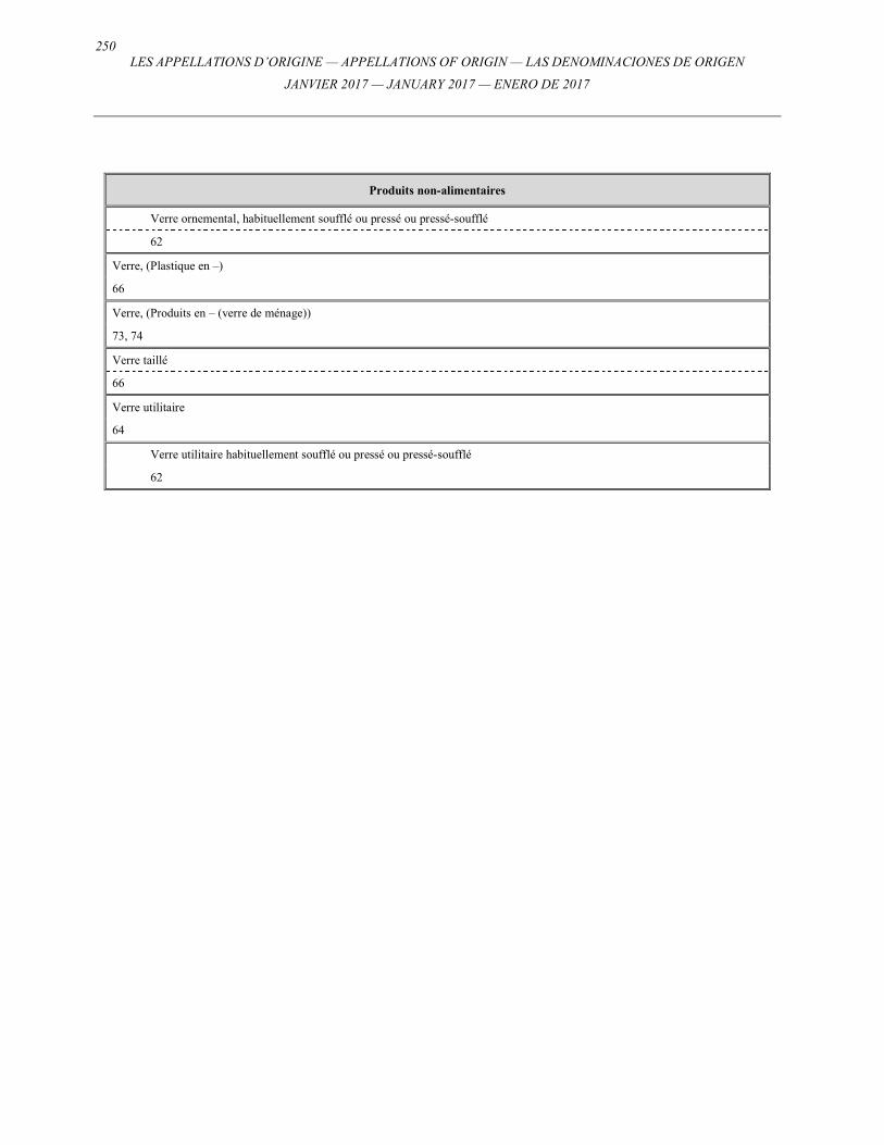
250 LES APPELLATIONS D’ORIGINE — APPELLATIONS OF ORIGIN — LAS DENOMINACIONES DE ORIGEN
JANVIER 2017 — JANUARY 2017 — ENERO DE 2017
Produits non-alimentaires
Verre ornemental, habituellement soufflé ou pressé ou pressé-soufflé
62
Verre, (Plastique en –)
66
Verre, (Produits en – (verre de ménage))
73, 74
Verre taillé
66
Verre utilitaire
64
Verre utilitaire habituellement soufflé ou pressé ou pressé-soufflé
62
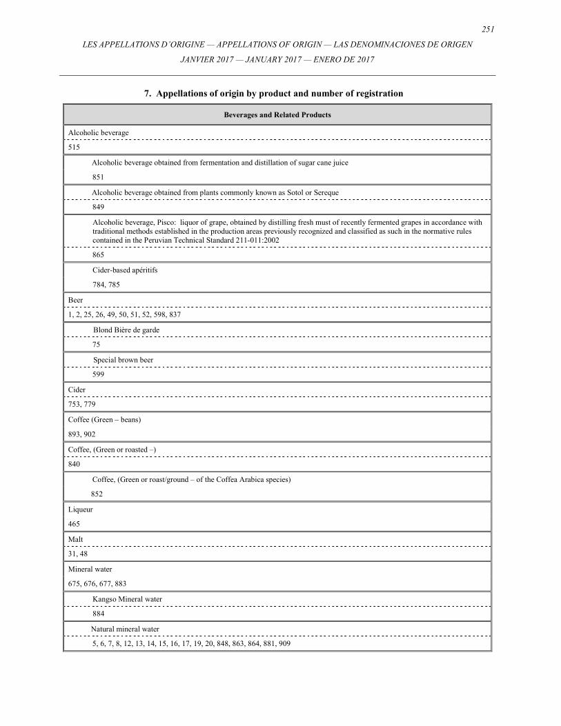
251
LES APPELLATIONS D’ORIGINE — APPELLATIONS OF ORIGIN — LAS DENOMINACIONES DE ORIGEN
JANVIER 2017 — JANUARY 2017 — ENERO DE 2017
7. Appellations of origin by product and number of registration
Beverages and Related Products
Alcoholic beverage
515
Alcoholic beverage obtained from fermentation and distillation of sugar cane juice
851
Alcoholic beverage obtained from plants commonly known as Sotol or Sereque
849
Alcoholic beverage, Pisco: liquor of grape, obtained by distilling fresh must of recently fermented grapes in accordance with traditional methods established in the production areas previously recognized and classified as such in the normative rules contained in the Peruvian Technical Standard 211-011:2002
865
Cider-based apéritifs
784, 785
Beer
1, 2, 25, 26, 49, 50, 51, 52, 598, 837
Blond Bière de garde
75
Special brown beer
599
Cider
753, 779
Coffee (Green – beans)
893, 902
Coffee, (Green or roasted –)
840
Coffee, (Green or roast/ground – of the Coffea Arabica species)
852
Liqueur
465
Malt
31, 48
Mineral water
675, 676, 677, 883
Kangso Mineral water
884
Natural mineral water
5, 6, 7, 8, 12, 13, 14, 15, 16, 17, 19, 20, 848, 863, 864, 881, 909
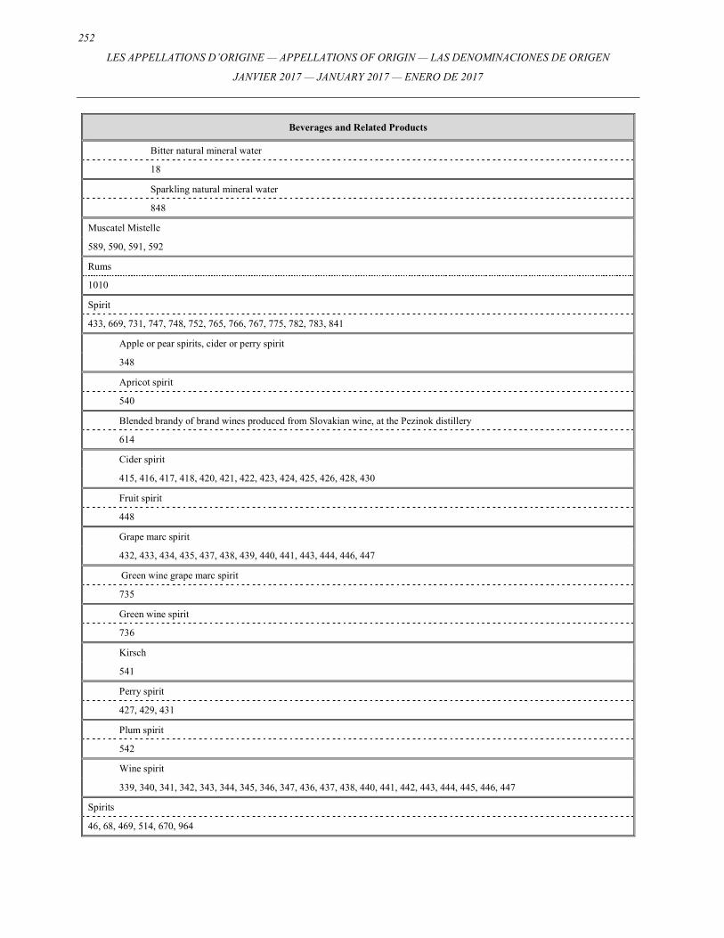
252
LES APPELLATIONS D’ORIGINE — APPELLATIONS OF ORIGIN — LAS DENOMINACIONES DE ORIGEN
JANVIER 2017 — JANUARY 2017 — ENERO DE 2017
Beverages and Related Products
Bitter natural mineral water
18
Sparkling natural mineral water
848
Muscatel Mistelle
589, 590, 591, 592
Rums
1010
Spirit
433, 669, 731, 747, 748, 752, 765, 766, 767, 775, 782, 783, 841
Apple or pear spirits, cider or perry spirit
348
Apricot spirit
540
Blended brandy of brand wines produced from Slovakian wine, at the Pezinok distillery
614
Cider spirit
415, 416, 417, 418, 420, 421, 422, 423, 424, 425, 426, 428, 430
Fruit spirit
448
Grape marc spirit
432, 433, 434, 435, 437, 438, 439, 440, 441, 443, 444, 446, 447
Green wine grape marc spirit
735
Green wine spirit
736
Kirsch
541
Perry spirit
427, 429, 431
Plum spirit
542
Wine spirit
339, 340, 341, 342, 343, 344, 345, 346, 347, 436, 437, 438, 440, 441, 442, 443, 444, 445, 446, 447
Spirits
46, 68, 469, 514, 670, 964
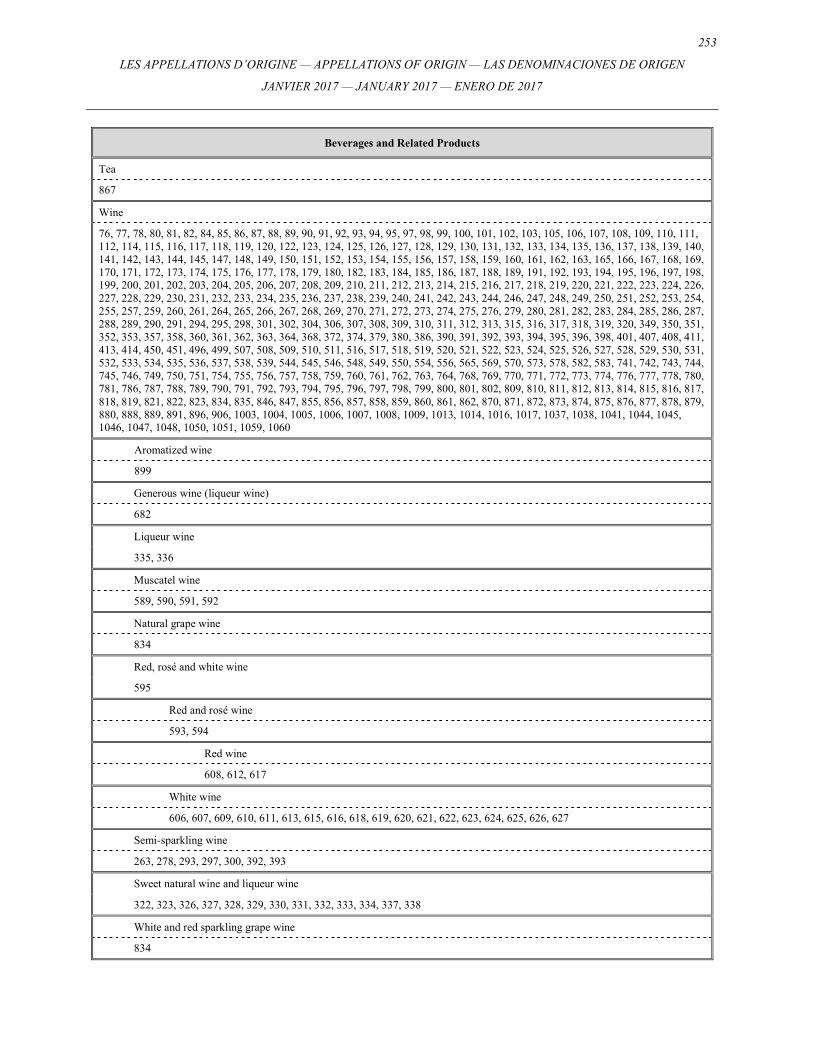
253
LES APPELLATIONS D’ORIGINE — APPELLATIONS OF ORIGIN — LAS DENOMINACIONES DE ORIGEN
JANVIER 2017 — JANUARY 2017 — ENERO DE 2017
Beverages and Related Products
Tea
867
Wine
76, 77, 78, 80, 81, 82, 84, 85, 86, 87, 88, 89, 90, 91, 92, 93, 94, 95, 97, 98, 99, 100, 101, 102, 103, 105, 106, 107, 108, 109, 110, 111, 112, 114, 115, 116, 117, 118, 119, 120, 122, 123, 124, 125, 126, 127, 128, 129, 130, 131, 132, 133, 134, 135, 136, 137, 138, 139, 140, 141, 142, 143, 144, 145, 147, 148, 149, 150, 151, 152, 153, 154, 155, 156, 157, 158, 159, 160, 161, 162, 163, 165, 166, 167, 168, 169, 170, 171, 172, 173, 174, 175, 176, 177, 178, 179, 180, 182, 183, 184, 185, 186, 187, 188, 189, 191, 192, 193, 194, 195, 196, 197, 198, 199, 200, 201, 202, 203, 204, 205, 206, 207, 208, 209, 210, 211, 212, 213, 214, 215, 216, 217, 218, 219, 220, 221, 222, 223, 224, 226, 227, 228, 229, 230, 231, 232, 233, 234, 235, 236, 237, 238, 239, 240, 241, 242, 243, 244, 246, 247, 248, 249, 250, 251, 252, 253, 254, 255, 257, 259, 260, 261, 264, 265, 266, 267, 268, 269, 270, 271, 272, 273, 274, 275, 276, 279, 280, 281, 282, 283, 284, 285, 286, 287, 288, 289, 290, 291, 294, 295, 298, 301, 302, 304, 306, 307, 308, 309, 310, 311, 312, 313, 315, 316, 317, 318, 319, 320, 349, 350, 351, 352, 353, 357, 358, 360, 361, 362, 363, 364, 368, 372, 374, 379, 380, 386, 390, 391, 392, 393, 394, 395, 396, 398, 401, 407, 408, 411, 413, 414, 450, 451, 496, 499, 507, 508, 509, 510, 511, 516, 517, 518, 519, 520, 521, 522, 523, 524, 525, 526, 527, 528, 529, 530, 531, 532, 533, 534, 535, 536, 537, 538, 539, 544, 545, 546, 548, 549, 550, 554, 556, 565, 569, 570, 573, 578, 582, 583, 741, 742, 743, 744, 745, 746, 749, 750, 751, 754, 755, 756, 757, 758, 759, 760, 761, 762, 763, 764, 768, 769, 770, 771, 772, 773, 774, 776, 777, 778, 780, 781, 786, 787, 788, 789, 790, 791, 792, 793, 794, 795, 796, 797, 798, 799, 800, 801, 802, 809, 810, 811, 812, 813, 814, 815, 816, 817, 818, 819, 821, 822, 823, 834, 835, 846, 847, 855, 856, 857, 858, 859, 860, 861, 862, 870, 871, 872, 873, 874, 875, 876, 877, 878, 879, 880, 888, 889, 891, 896, 906, 1003, 1004, 1005, 1006, 1007, 1008, 1009, 1013, 1014, 1016, 1017, 1037, 1038, 1041, 1044, 1045, 1046, 1047, 1048, 1050, 1051, 1059, 1060
Aromatized wine
899
Generous wine (liqueur wine)
682
Liqueur wine
335, 336
Muscatel wine
589, 590, 591, 592
Natural grape wine
834
Red, rosé and white wine
595
Red and rosé wine
593, 594
Red wine
608, 612, 617
White wine
606, 607, 609, 610, 611, 613, 615, 616, 618, 619, 620, 621, 622, 623, 624, 625, 626, 627
Semi-sparkling wine
263, 278, 293, 297, 300, 392, 393
Sweet natural wine and liqueur wine
322, 323, 326, 327, 328, 329, 330, 331, 332, 333, 334, 337, 338
White and red sparkling grape wine
834
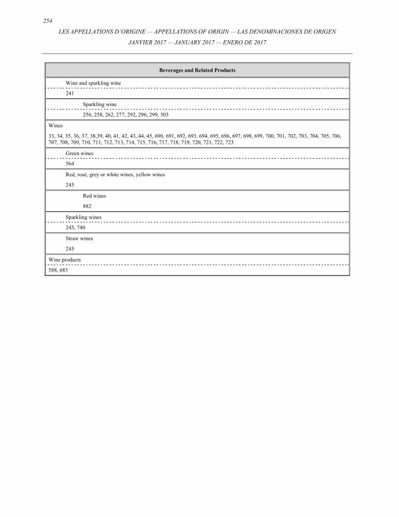
254
LES APPELLATIONS D’ORIGINE — APPELLATIONS OF ORIGIN — LAS DENOMINACIONES DE ORIGEN
JANVIER 2017 — JANUARY 2017 — ENERO DE 2017
Beverages and Related Products
Wine and sparkling wine
241
Sparkling wine
256, 258, 262, 277, 292, 296, 299, 303
Wines
33, 34, 35, 36, 37, 38,39, 40, 41, 42, 43, 44, 45, 690, 691, 692, 693, 694, 695, 696, 697, 698, 699, 700, 701, 702, 703, 704, 705, 706, 707, 708, 709, 710, 711, 712, 713, 714, 715, 716, 717, 718, 719, 720, 721, 722, 723
Green wines
564
Red, rosé, grey or white wines, yellow wines
245
Red wines
882
Sparkling wines
245, 740
Straw wines
245
Wine products
588, 683
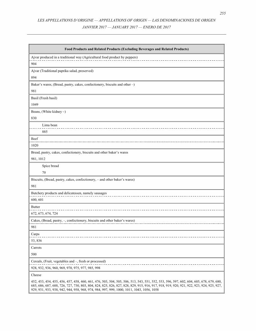
255
LES APPELLATIONS D’ORIGINE — APPELLATIONS OF ORIGIN — LAS DENOMINACIONES DE ORIGEN
JANVIER 2017 — JANUARY 2017 — ENERO DE 2017
Food Products and Related Products (Excluding Beverages and Related Products)
Ajvar produced in a traditional way (Agricultural food product by peppers)
904
Ajvar (Traditional paprika salad, preserved)
894
Baker’s wares, (Bread, pastry, cakes, confectionery, biscuits and other –)
981
Basil (Fresh basil)
1049
Beans, (White kidney –)
830
Lima bean
885
Beef
1020
Bread, pastry, cakes, confectionery, biscuits and other baker’s wares
981, 1012
Spice bread
70
Biscuits, (Bread, pastry, cakes, confectionery, – and other baker’s wares)
981
Butchery products and delicatessen, namely sausages
600, 601
Butter
672, 673, 674, 724
Cakes, (Bread, pastry, –, confectionery, biscuits and other baker’s wares)
981
Carps
53, 836
Carrots
500
Cereals, (Fruit, vegetables and –, fresh or processed)
928, 932, 936, 960, 969, 970, 975, 977, 985, 998
Cheese
452, 453, 454, 455, 456, 457, 458, 460, 461, 476, 503, 504, 505, 506, 513, 543, 551, 552, 553, 596, 597, 602, 604, 605, 678, 679, 680, 685, 686, 687, 688, 726, 727, 730, 803, 804, 824, 825, 826, 827, 828, 829, 915, 916, 917, 918, 919, 920, 921, 922, 923, 924, 925, 927, 929, 931, 933, 938, 942, 944, 958, 968, 974, 984, 997, 999, 1000, 1011, 1043, 1056, 1058
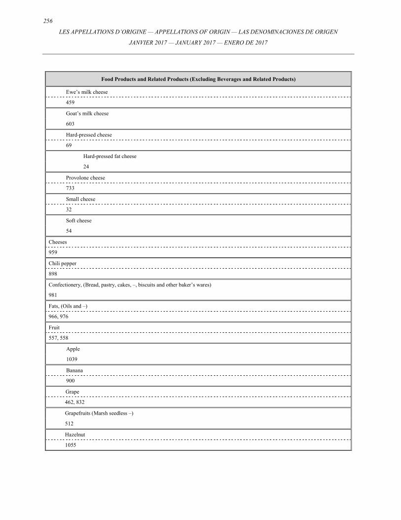
256
LES APPELLATIONS D’ORIGINE — APPELLATIONS OF ORIGIN — LAS DENOMINACIONES DE ORIGEN
JANVIER 2017 — JANUARY 2017 — ENERO DE 2017
Food Products and Related Products (Excluding Beverages and Related Products)
Ewe’s milk cheese
459
Goat’s milk cheese
603
Hard-pressed cheese
69
Hard-pressed fat cheese
24
Provolone cheese
733
Small cheese
32
Soft cheese
54
Cheeses
959
Chili pepper
898
Confectionery, (Bread, pastry, cakes, –, biscuits and other baker’s wares)
981
Fats, (Oils and –)
966, 976
Fruit
557, 558
Apple
1039
Banana
900
Grape
462, 832
Grapefruits (Marsh seedless –)
512
Hazelnut
1055
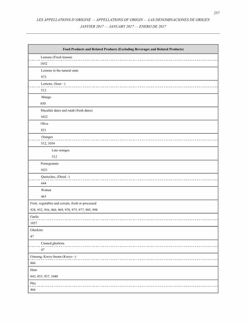
257
LES APPELLATIONS D’ORIGINE — APPELLATIONS OF ORIGIN — LAS DENOMINACIONES DE ORIGEN
JANVIER 2017 — JANUARY 2017 — ENERO DE 2017
Food Products and Related Products (Excluding Beverages and Related Products)
Lemons (Fresh lemon)
1052
Lemons in the natural state
972
Lemons, (Sour –)
512
Mango
850
Mazafati dates and rutab (fresh dates)
1022
Olive
831
Oranges
512, 1054
Late oranges
512
Pomegranate
1021
Quetsches, (Dried –)
644
Walnut
463
Fruit, vegetables and cereals, fresh or processed
928, 932, 936, 960, 969, 970, 975, 977, 985, 998
Garlic
1057
Gherkins
47
Canned gherkins
47
Ginseng, Koryo Insam (Koryo –)
866
Ham
843, 853, 937, 1040
Hay
466
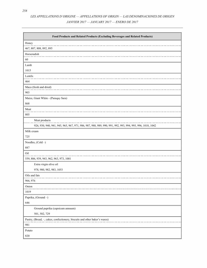
258
LES APPELLATIONS D’ORIGINE — APPELLATIONS OF ORIGIN — LAS DENOMINACIONES DE ORIGEN
JANVIER 2017 — JANUARY 2017 — ENERO DE 2017
Food Products and Related Products (Excluding Beverages and Related Products)
Honey
467, 807, 808, 892, 895
Horseradish
60
Lamb
1015
Lentils
464
Maca (fresh and dried)
903
Maize, Giant White - (Paraqay Sara)
868
Meat
805
Meat products
926, 930, 940, 941, 945, 965, 967, 971, 986, 987, 988, 989, 990, 991, 992, 993, 994, 995, 996, 1018, 1042
Milk cream
725
Noodles, (Cold –)
887
Oil
559, 806, 939, 943, 962, 963, 973, 1001
Extra virgin olive oil
978, 980, 982, 983, 1053
Oils and fats
966, 976
Onion
1019
Paprika, (Ground –)
646
Ground paprika (capsicum annuum)
501, 502, 729
Pastry, (Bread, –, cakes, confectionery, biscuits and other baker’s wares)
981
Potato
820
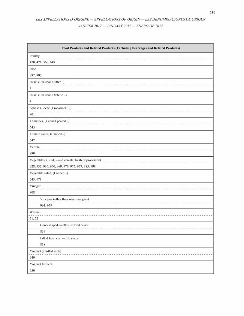
259
LES APPELLATIONS D’ORIGINE — APPELLATIONS OF ORIGIN — LAS DENOMINACIONES DE ORIGEN
JANVIER 2017 — JANUARY 2017 — ENERO DE 2017
Food Products and Related Products (Excluding Beverages and Related Products)
Poultry
470, 471, 560, 648
Rice
897, 905
Rusk, (Carlsbad Butter –)
4
Rusk, (Carlsbad Dietetic –)
4
Squash (Loche (Crookneck –))
901
Tomatoes, (Canned pealed –)
645
Tomato sauce, (Canned –)
647
Vanilla
890
Vegetables, (Fruit, – and cereals, fresh or processed)
928, 932, 936, 960, 969, 970, 975, 977, 985, 998
Vegetable salad, (Canned –)
643, 671
Vinegar
908
Vinegars (other than wine vinegars)
961, 979
Wafers
71, 72
Cone-shaped waffles, stuffed or not
839
Filled layers of waffle slices
838
Yoghurt (curdled milk)
649
Yoghurt ferment
650
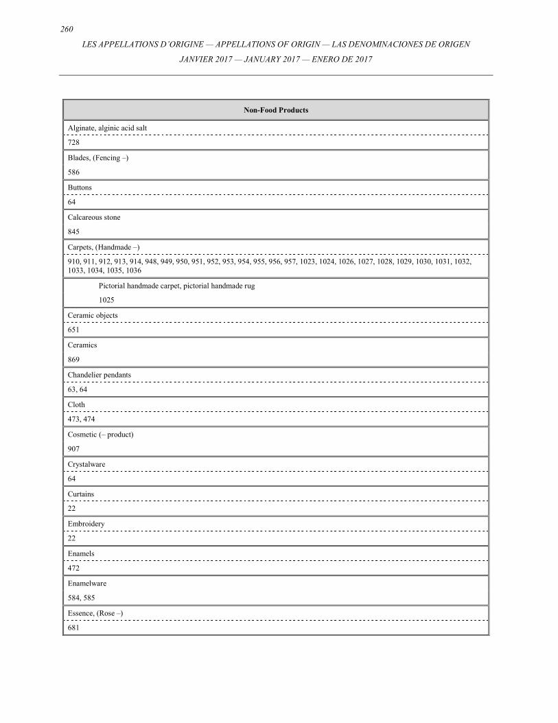
260
LES APPELLATIONS D’ORIGINE — APPELLATIONS OF ORIGIN — LAS DENOMINACIONES DE ORIGEN
JANVIER 2017 — JANUARY 2017 — ENERO DE 2017
Non-Food Products
Alginate, alginic acid salt
728
Blades, (Fencing –)
586
Buttons
64
Calcareous stone
845
Carpets, (Handmade –)
910, 911, 912, 913, 914, 948, 949, 950, 951, 952, 953, 954, 955, 956, 957, 1023, 1024, 1026, 1027, 1028, 1029, 1030, 1031, 1032, 1033, 1034, 1035, 1036
Pictorial handmade carpet, pictorial handmade rug
1025
Ceramic objects
651
Ceramics
869
Chandelier pendants
63, 64
Cloth
473, 474
Cosmetic (– product)
907
Crystalware
64
Curtains
22
Embroidery
22
Enamels
472
Enamelware
584, 585
Essence, (Rose –)
681
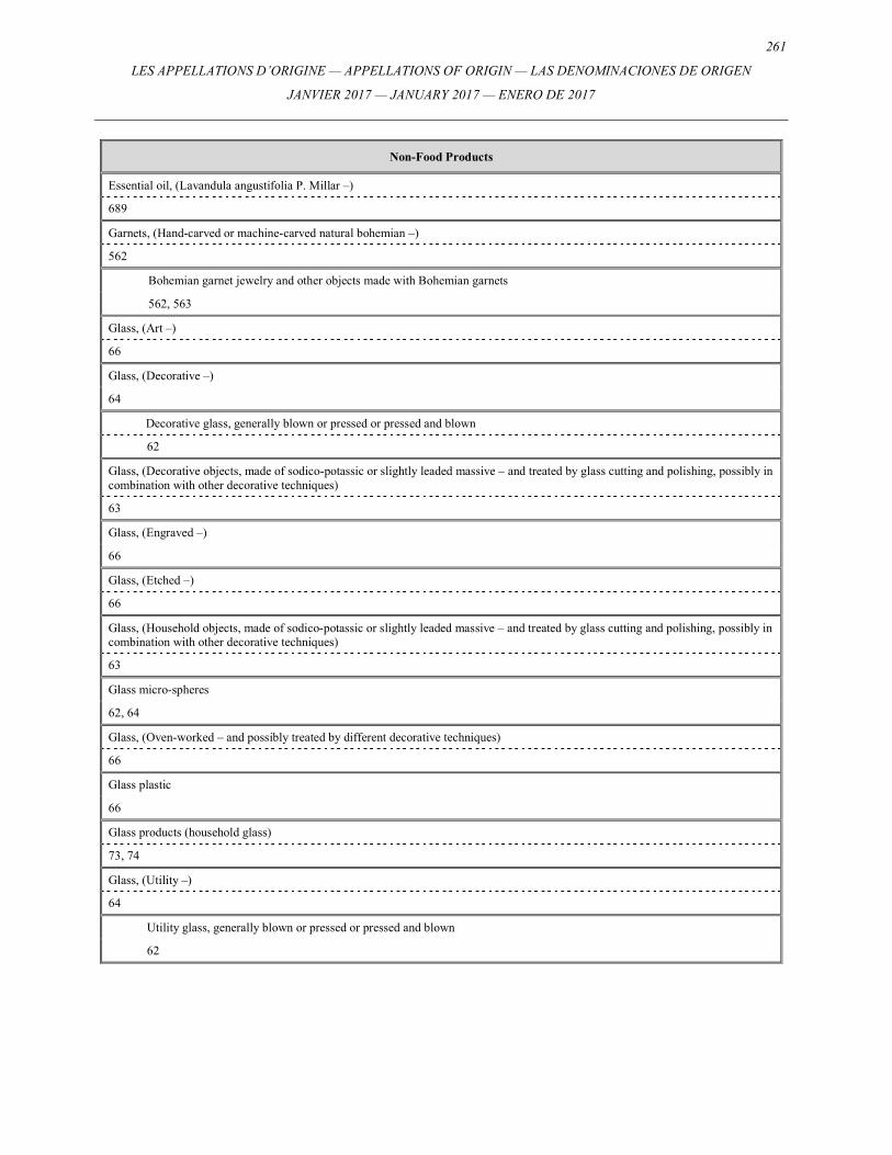
261
LES APPELLATIONS D’ORIGINE — APPELLATIONS OF ORIGIN — LAS DENOMINACIONES DE ORIGEN
JANVIER 2017 — JANUARY 2017 — ENERO DE 2017
Non-Food Products
Essential oil, (Lavandula angustifolia P. Millar –)
689
Garnets, (Hand-carved or machine-carved natural bohemian –)
562
Bohemian garnet jewelry and other objects made with Bohemian garnets
562, 563
Glass, (Art –)
66
Glass, (Decorative –)
64
Decorative glass, generally blown or pressed or pressed and blown
62
Glass, (Decorative objects, made of sodico-potassic or slightly leaded massive – and treated by glass cutting and polishing, possibly in combination with other decorative techniques)
63
Glass, (Engraved –)
66
Glass, (Etched –)
66
Glass, (Household objects, made of sodico-potassic or slightly leaded massive – and treated by glass cutting and polishing, possibly in combination with other decorative techniques)
63
Glass micro-spheres
62, 64
Glass, (Oven-worked – and possibly treated by different decorative techniques)
66
Glass plastic
66
Glass products (household glass)
73, 74
Glass, (Utility –)
64
Utility glass, generally blown or pressed or pressed and blown
62
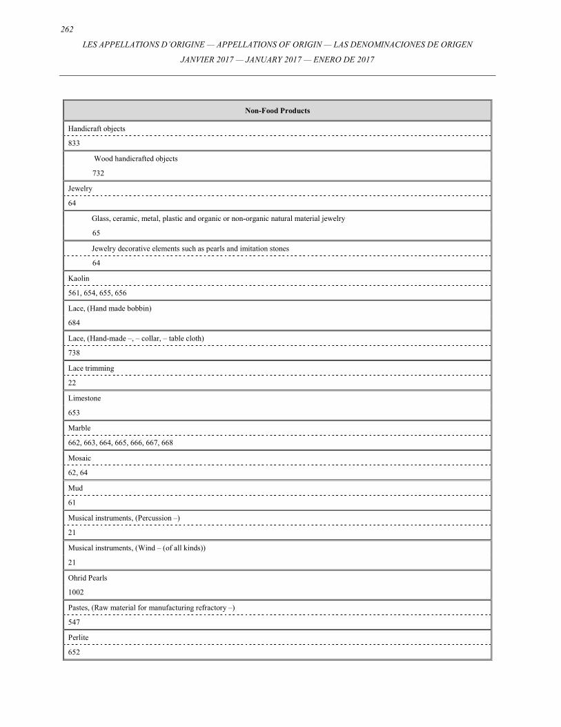
262
LES APPELLATIONS D’ORIGINE — APPELLATIONS OF ORIGIN — LAS DENOMINACIONES DE ORIGEN
JANVIER 2017 — JANUARY 2017 — ENERO DE 2017
Non-Food Products
Handicraft objects
833
Wood handicrafted objects
732
Jewelry
64
Glass, ceramic, metal, plastic and organic or non-organic natural material jewelry
65
Jewelry decorative elements such as pearls and imitation stones
64
Kaolin
561, 654, 655, 656
Lace, (Hand made bobbin)
684
Lace, (Hand-made –, – collar, – table cloth)
738
Lace trimming
22
Limestone
653
Marble
662, 663, 664, 665, 666, 667, 668
Mosaic
62, 64
Mud
61
Musical instruments, (Percussion –)
21
Musical instruments, (Wind – (of all kinds))
21
Ohrid Pearls
1002
Pastes, (Raw material for manufacturing refractory –)
547
Perlite
652
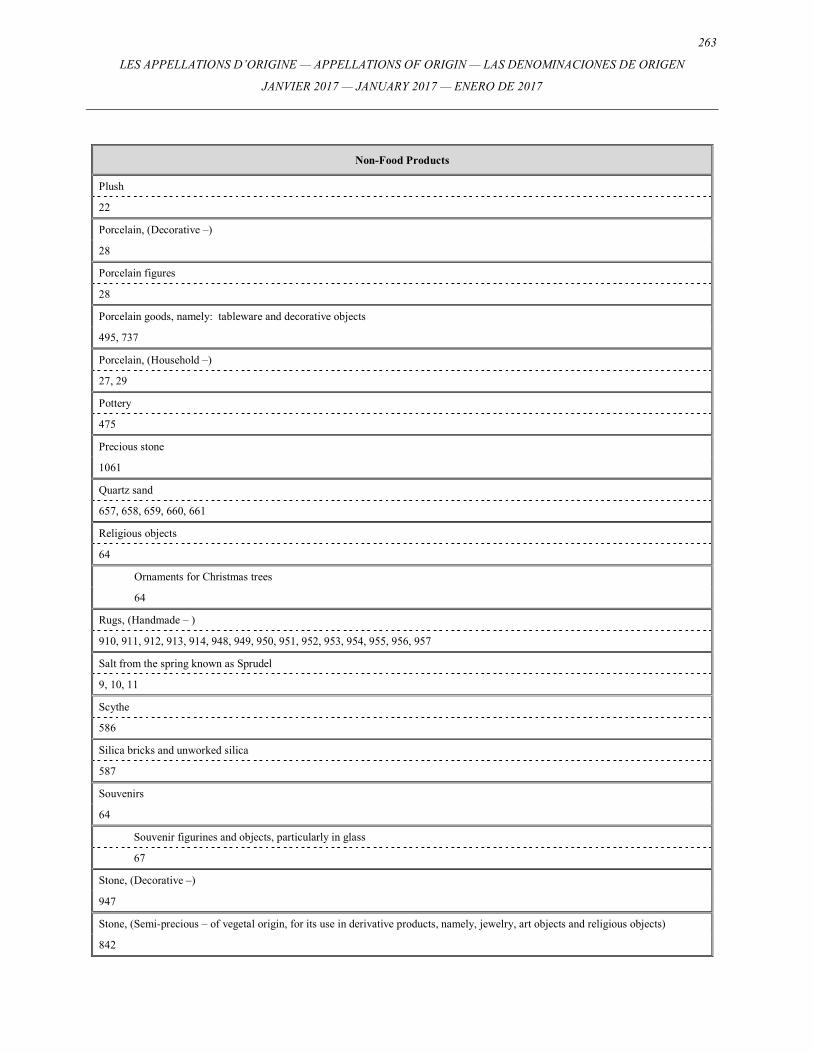
263
LES APPELLATIONS D’ORIGINE — APPELLATIONS OF ORIGIN — LAS DENOMINACIONES DE ORIGEN
JANVIER 2017 — JANUARY 2017 — ENERO DE 2017
Non-Food Products
Plush
22
Porcelain, (Decorative –)
28
Porcelain figures
28
Porcelain goods, namely: tableware and decorative objects
495, 737
Porcelain, (Household –)
27, 29
Pottery
475
Precious stone
1061
Quartz sand
657, 658, 659, 660, 661
Religious objects
64
Ornaments for Christmas trees
64
Rugs, (Handmade – )
910, 911, 912, 913, 914, 948, 949, 950, 951, 952, 953, 954, 955, 956, 957
Salt from the spring known as Sprudel
9, 10, 11
Scythe
586
Silica bricks and unworked silica
587
Souvenirs
64
Souvenir figurines and objects, particularly in glass
67
Stone, (Decorative –)
947
Stone, (Semi-precious – of vegetal origin, for its use in derivative products, namely, jewelry, art objects and religious objects)
842
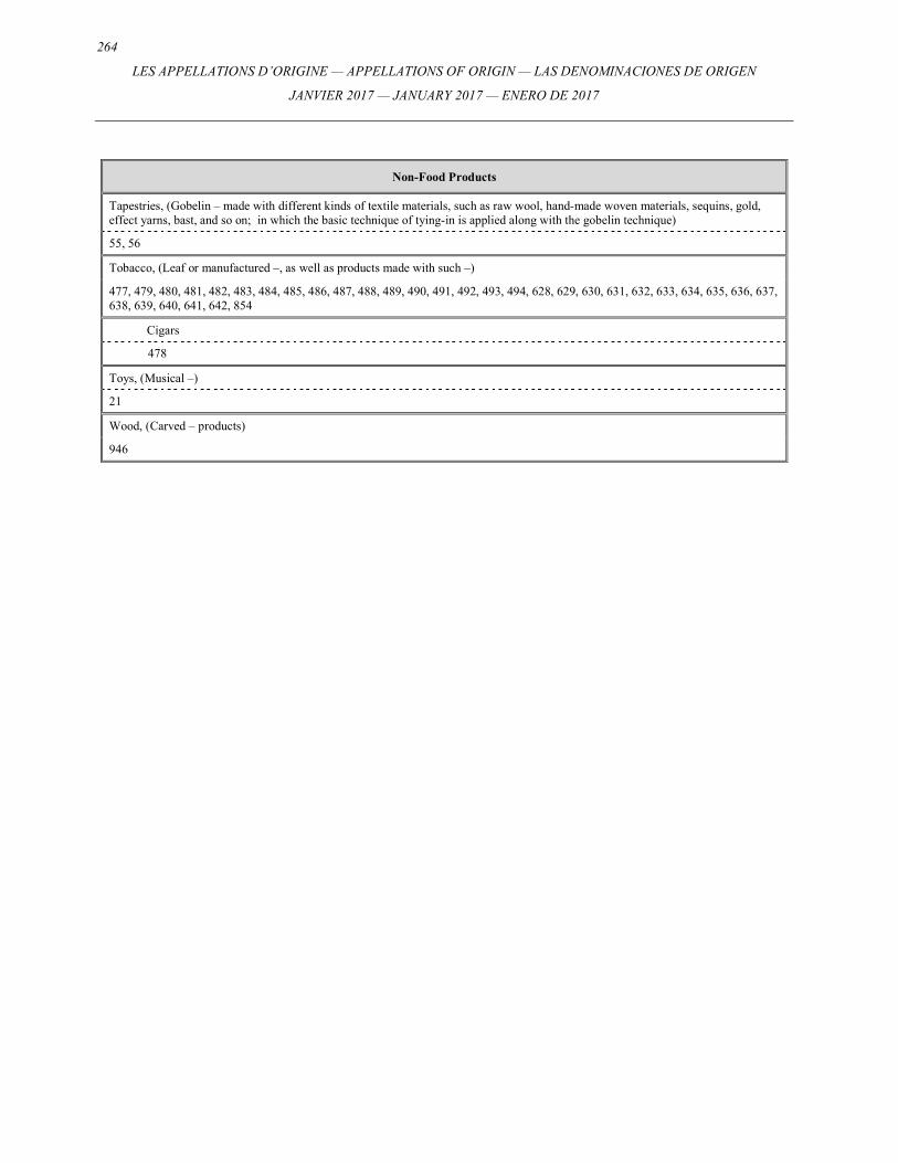
264
LES APPELLATIONS D’ORIGINE — APPELLATIONS OF ORIGIN — LAS DENOMINACIONES DE ORIGEN
JANVIER 2017 — JANUARY 2017 — ENERO DE 2017
Non-Food Products
Tapestries, (Gobelin – made with different kinds of textile materials, such as raw wool, hand-made woven materials, sequins, gold, effect yarns, bast, and so on; in which the basic technique of tying-in is applied along with the gobelin technique)
55, 56
Tobacco, (Leaf or manufactured –, as well as products made with such –)
477, 479, 480, 481, 482, 483, 484, 485, 486, 487, 488, 489, 490, 491, 492, 493, 494, 628, 629, 630, 631, 632, 633, 634, 635, 636, 637, 638, 639, 640, 641, 642, 854
Cigars
478
Toys, (Musical –)
21
Wood, (Carved – products)
946
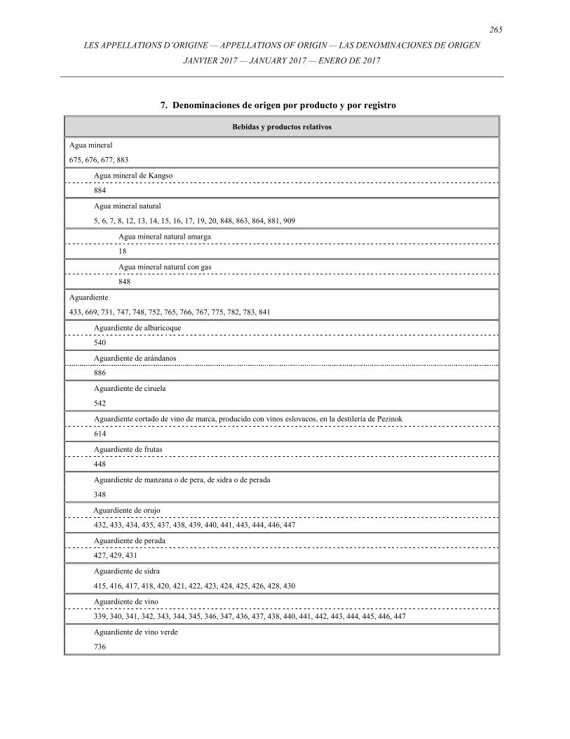
265
LES APPELLATIONS D’ORIGINE — APPELLATIONS OF ORIGIN — LAS DENOMINACIONES DE ORIGEN
JANVIER 2017 — JANUARY 2017 — ENERO DE 2017
7. Denominaciones de origen por producto y por registro
Bebidas y productos relativos
Agua mineral
675, 676, 677, 883
Agua mineral de Kangso
884
Agua mineral natural
5, 6, 7, 8, 12, 13, 14, 15, 16, 17, 19, 20, 848, 863, 864, 881, 909
Agua mineral natural amarga
18
Agua mineral natural con gas
848
Aguardiente
433, 669, 731, 747, 748, 752, 765, 766, 767, 775, 782, 783, 841
Aguardiente de albaricoque
540
Aguardiente de arándanos
886
Aguardiente de ciruela
542
Aguardiente cortado de vino de marca, producido con vinos eslovacos, en la destilería de Pezinok
614
Aguardiente de frutas
448
Aguardiente de manzana o de pera, de sidra o de perada
348
Aguardiente de orujo
432, 433, 434, 435, 437, 438, 439, 440, 441, 443, 444, 446, 447
Aguardiente de perada
427, 429, 431
Aguardiente de sidra
415, 416, 417, 418, 420, 421, 422, 423, 424, 425, 426, 428, 430
Aguardiente de vino
339, 340, 341, 342, 343, 344, 345, 346, 347, 436, 437, 438, 440, 441, 442, 443, 444, 445, 446, 447
Aguardiente de vino verde
736
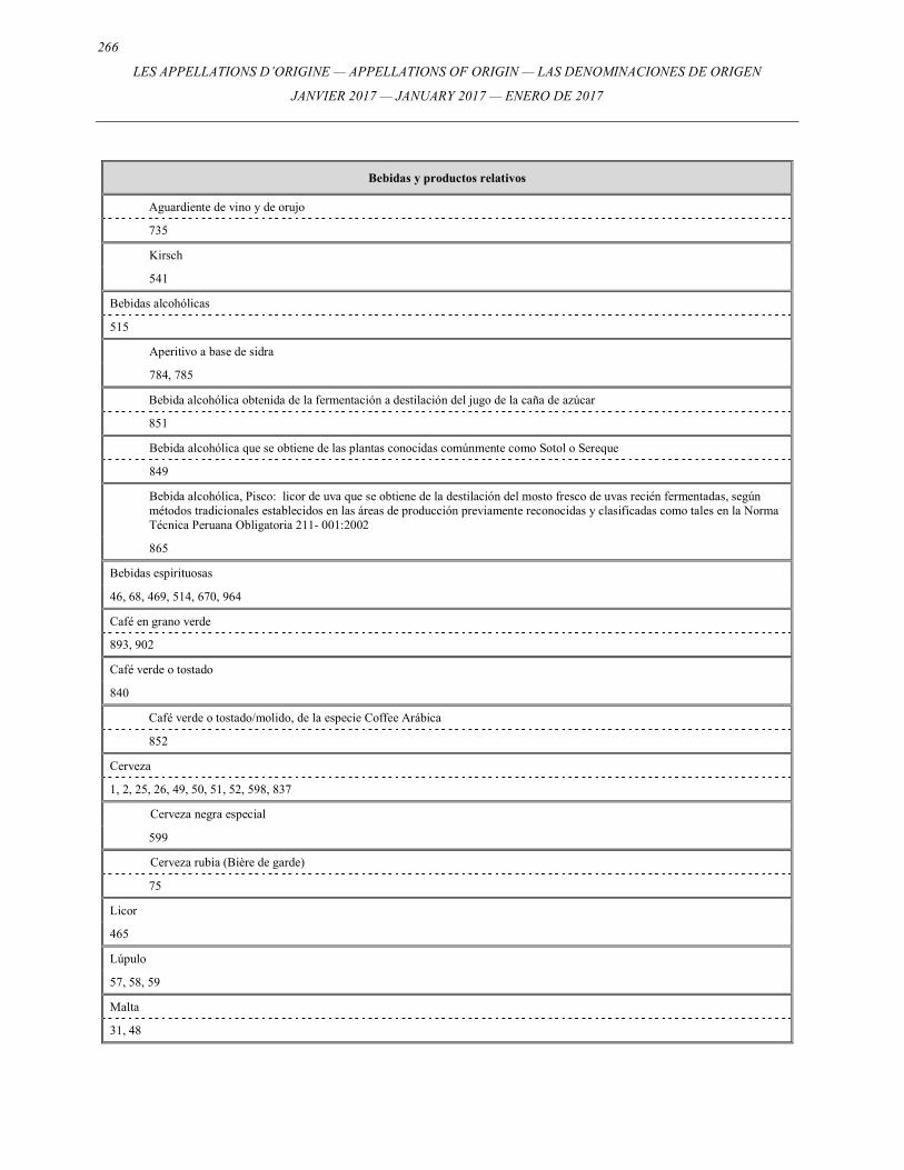
266
LES APPELLATIONS D’ORIGINE — APPELLATIONS OF ORIGIN — LAS DENOMINACIONES DE ORIGEN
JANVIER 2017 — JANUARY 2017 — ENERO DE 2017
Bebidas y productos relativos
Aguardiente de vino y de orujo
735
Kirsch
541
Bebidas alcohólicas
515
Aperitivo a base de sidra
784, 785
Bebida alcohólica obtenida de la fermentación a destilación del jugo de la caña de azúcar
851
Bebida alcohólica que se obtiene de las plantas conocidas comúnmente como Sotol o Sereque
849
Bebida alcohólica, Pisco: licor de uva que se obtiene de la destilación del mosto fresco de uvas recién fermentadas, según métodos tradicionales establecidos en las áreas de producción previamente reconocidas y clasificadas como tales en la Norma Técnica Peruana Obligatoria 211- 001:2002
865
Bebidas espirituosas
46, 68, 469, 514, 670, 964
Café en grano verde
893, 902
Café verde o tostado
840
Café verde o tostado/molido, de la especie Coffee Arábica
852
Cerveza
1, 2, 25, 26, 49, 50, 51, 52, 598, 837
Cerveza negra especial
599
Cerveza rubia (Bière de garde)
75
Licor
465
Lúpulo
57, 58, 59
Malta
31, 48
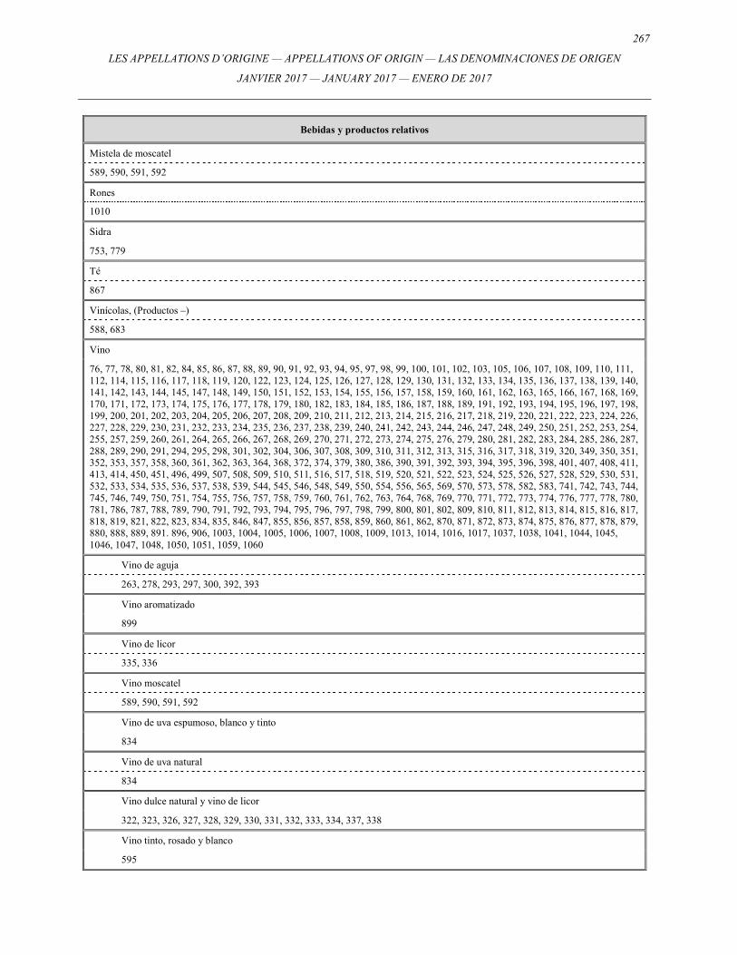
267
LES APPELLATIONS D’ORIGINE — APPELLATIONS OF ORIGIN — LAS DENOMINACIONES DE ORIGEN
JANVIER 2017 — JANUARY 2017 — ENERO DE 2017
Bebidas y productos relativos
Mistela de moscatel
589, 590, 591, 592
Rones
1010
Sidra
753, 779
Té
867
Vinícolas, (Productos –)
588, 683
Vino
76, 77, 78, 80, 81, 82, 84, 85, 86, 87, 88, 89, 90, 91, 92, 93, 94, 95, 97, 98, 99, 100, 101, 102, 103, 105, 106, 107, 108, 109, 110, 111, 112, 114, 115, 116, 117, 118, 119, 120, 122, 123, 124, 125, 126, 127, 128, 129, 130, 131, 132, 133, 134, 135, 136, 137, 138, 139, 140, 141, 142, 143, 144, 145, 147, 148, 149, 150, 151, 152, 153, 154, 155, 156, 157, 158, 159, 160, 161, 162, 163, 165, 166, 167, 168, 169, 170, 171, 172, 173, 174, 175, 176, 177, 178, 179, 180, 182, 183, 184, 185, 186, 187, 188, 189, 191, 192, 193, 194, 195, 196, 197, 198, 199, 200, 201, 202, 203, 204, 205, 206, 207, 208, 209, 210, 211, 212, 213, 214, 215, 216, 217, 218, 219, 220, 221, 222, 223, 224, 226, 227, 228, 229, 230, 231, 232, 233, 234, 235, 236, 237, 238, 239, 240, 241, 242, 243, 244, 246, 247, 248, 249, 250, 251, 252, 253, 254, 255, 257, 259, 260, 261, 264, 265, 266, 267, 268, 269, 270, 271, 272, 273, 274, 275, 276, 279, 280, 281, 282, 283, 284, 285, 286, 287, 288, 289, 290, 291, 294, 295, 298, 301, 302, 304, 306, 307, 308, 309, 310, 311, 312, 313, 315, 316, 317, 318, 319, 320, 349, 350, 351, 352, 353, 357, 358, 360, 361, 362, 363, 364, 368, 372, 374, 379, 380, 386, 390, 391, 392, 393, 394, 395, 396, 398, 401, 407, 408, 411, 413, 414, 450, 451, 496, 499, 507, 508, 509, 510, 511, 516, 517, 518, 519, 520, 521, 522, 523, 524, 525, 526, 527, 528, 529, 530, 531, 532, 533, 534, 535, 536, 537, 538, 539, 544, 545, 546, 548, 549, 550, 554, 556, 565, 569, 570, 573, 578, 582, 583, 741, 742, 743, 744, 745, 746, 749, 750, 751, 754, 755, 756, 757, 758, 759, 760, 761, 762, 763, 764, 768, 769, 770, 771, 772, 773, 774, 776, 777, 778, 780, 781, 786, 787, 788, 789, 790, 791, 792, 793, 794, 795, 796, 797, 798, 799, 800, 801, 802, 809, 810, 811, 812, 813, 814, 815, 816, 817, 818, 819, 821, 822, 823, 834, 835, 846, 847, 855, 856, 857, 858, 859, 860, 861, 862, 870, 871, 872, 873, 874, 875, 876, 877, 878, 879, 880, 888, 889, 891. 896, 906, 1003, 1004, 1005, 1006, 1007, 1008, 1009, 1013, 1014, 1016, 1017, 1037, 1038, 1041, 1044, 1045, 1046, 1047, 1048, 1050, 1051, 1059, 1060
Vino de aguja
263, 278, 293, 297, 300, 392, 393
Vino aromatizado
899
Vino de licor
335, 336
Vino moscatel
589, 590, 591, 592
Vino de uva espumoso, blanco y tinto
834
Vino de uva natural
834
Vino dulce natural y vino de licor
322, 323, 326, 327, 328, 329, 330, 331, 332, 333, 334, 337, 338
Vino tinto, rosado y blanco
595
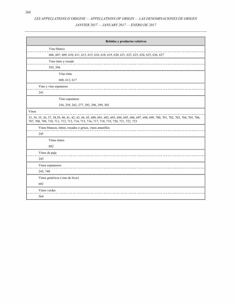
268
LES APPELLATIONS D’ORIGINE — APPELLATIONS OF ORIGIN — LAS DENOMINACIONES DE ORIGEN
JANVIER 2017 — JANUARY 2017 — ENERO DE 2017
Bebidas y productos relativos
Vino blanco
606, 607, 609, 610, 611, 613, 615, 616, 618, 619, 620, 621, 622, 623, 624, 625, 626, 627
Vino tinto y rosado
593, 594
Vino tinto
608, 612, 617
Vino y vino espumoso
241
Vino espumoso
256, 258, 262, 277, 292, 296, 299, 303
Vinos
33, 34, 35, 36, 37, 38,39, 40, 41, 42, 43, 44, 45, 690, 691, 692, 693, 694, 695, 696, 697, 698, 699, 700, 701, 702, 703, 704, 705, 706, 707, 708, 709, 710, 711, 712, 713, 714, 715, 716, 717, 718, 719, 720, 721, 722, 723
Vinos blancos, tintos, rosados o grises, vinos amarillos
245
Vinos tintos
882
Vinos de paja
245
Vinos espumosos
245, 740
Vinos genéricos (vino de licor)
682
Vinos verdes
564
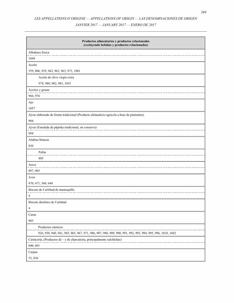
269
LES APPELLATIONS D’ORIGINE — APPELLATIONS OF ORIGIN — LAS DENOMINACIONES DE ORIGEN
JANVIER 2017 — JANUARY 2017 — ENERO DE 2017
Productos alimentarios y productos relacionados (excluyendo bebidas y productos relacionados)
Albahaca fresca
1049
Aceite
559, 806, 939, 943, 962, 963, 973, 1001
Aceite de olive virgin extra
978, 980, 982, 983, 1053
Aceites y grasas
966, 976
Ajo
1057
Ajvar elaborado de forma tradicional (Producto alimenticio agrícola a base de pimientos)
904
Ajvar (Ensalada de páprika tradicional, en conserva)
894
Alubias blancas
830
Pallar
885
Arroz
897, 905
Aves
470, 471, 560, 648
Biscote de Carlsbad de mantequilla
4
Biscote dietético de Carlsbad
4
Carne
805
Productos cárnicos
926, 930, 940, 941, 945, 965, 967, 971, 986, 987, 988, 989, 990, 991, 992, 993, 994, 995, 996, 1018, 1042
Carnicería, (Productos de – y de charcutería, principalmente salchichas)
600, 601
Carpas
53, 836
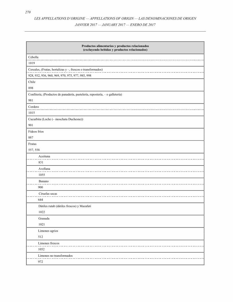
270
LES APPELLATIONS D’ORIGINE — APPELLATIONS OF ORIGIN — LAS DENOMINACIONES DE ORIGEN
JANVIER 2017 — JANUARY 2017 — ENERO DE 2017
Productos alimentarios y productos relacionados (excluyendo bebidas y productos relacionados)
Cebolla
1019
Cereales, (Frutas, hortalizas y –, frescos o transformados)
928, 932, 936, 960, 969, 970, 975, 977, 985, 998
Chile
898
Confitería, (Productos de panadería, pastelería, repostería, – o galletería)
981
Cordero
1015
Cucurbita (Loche (– moschata Duchesne))
901
Fideos fríos
887
Frutas
557, 558
Aceituna
831
Avellana
1055
Banano
900
Ciruelas secas
644
Dátiles rutab (dátiles frescos) y Mazafati
1022
Granada
1021
Limones agrios
512
Limones frescos
1052
Limones no transformados
972
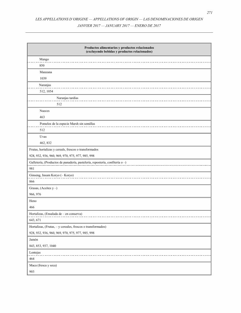
271
LES APPELLATIONS D’ORIGINE — APPELLATIONS OF ORIGIN — LAS DENOMINACIONES DE ORIGEN
JANVIER 2017 — JANUARY 2017 — ENERO DE 2017
Productos alimentarios y productos relacionados (excluyendo bebidas y productos relacionados)
Mango
850
Manzana
1039
Naranjas
512, 1054
Naranjas tardías
512
Nueces
463
Pomelos de la especie Marsh sin semillas
512
Uvas
462, 832
Frutas, hortalizas y cereals, frescos o transformados
928, 932, 936, 960, 969, 970, 975, 977, 985, 998
Galletería, (Productos de panadería, pastelería, repostería, confitería o –)
981
Ginseng, Insam Koryo (– Koryo)
866
Grasas, (Aceites y –)
966, 976
Heno
466
Hortalizas, (Ensalada de – en conserva)
643, 671
Hortalizas, (Frutas, – y cereales, frescos o transformados)
928, 932, 936, 960, 969, 970, 975, 977, 985, 998
Jamón
843, 853, 937, 1040
Lentejas
464
Maca (fresca y seca)
903
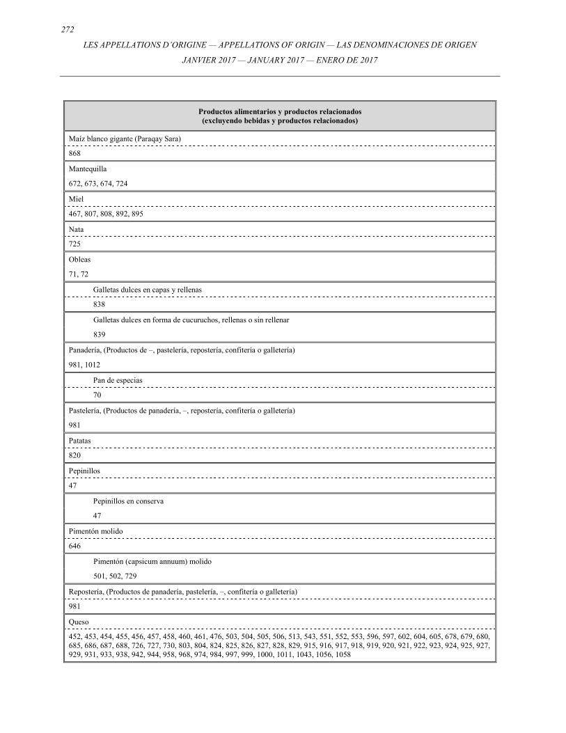
272
LES APPELLATIONS D’ORIGINE — APPELLATIONS OF ORIGIN — LAS DENOMINACIONES DE ORIGEN
JANVIER 2017 — JANUARY 2017 — ENERO DE 2017
Productos alimentarios y productos relacionados (excluyendo bebidas y productos relacionados)
Maíz blanco gigante (Paraqay Sara)
868
Mantequilla
672, 673, 674, 724
Miel
467, 807, 808, 892, 895
Nata
725
Obleas
71, 72
Galletas dulces en capas y rellenas
838
Galletas dulces en forma de cucuruchos, rellenas o sin rellenar
839
Panadería, (Productos de –, pastelería, repostería, confitería o galletería)
981, 1012
Pan de especias
70
Pastelería, (Productos de panadería, –, repostería, confitería o galletería)
981
Patatas
820
Pepinillos
47
Pepinillos en conserva
47
Pimentón molido
646
Pimentón (capsicum annuum) molido
501, 502, 729
Repostería, (Productos de panadería, pastelería, –, confitería o galletería)
981
Queso
452, 453, 454, 455, 456, 457, 458, 460, 461, 476, 503, 504, 505, 506, 513, 543, 551, 552, 553, 596, 597, 602, 604, 605, 678, 679, 680, 685, 686, 687, 688, 726, 727, 730, 803, 804, 824, 825, 826, 827, 828, 829, 915, 916, 917, 918, 919, 920, 921, 922, 923, 924, 925, 927, 929, 931, 933, 938, 942, 944, 958, 968, 974, 984, 997, 999, 1000, 1011, 1043, 1056, 1058
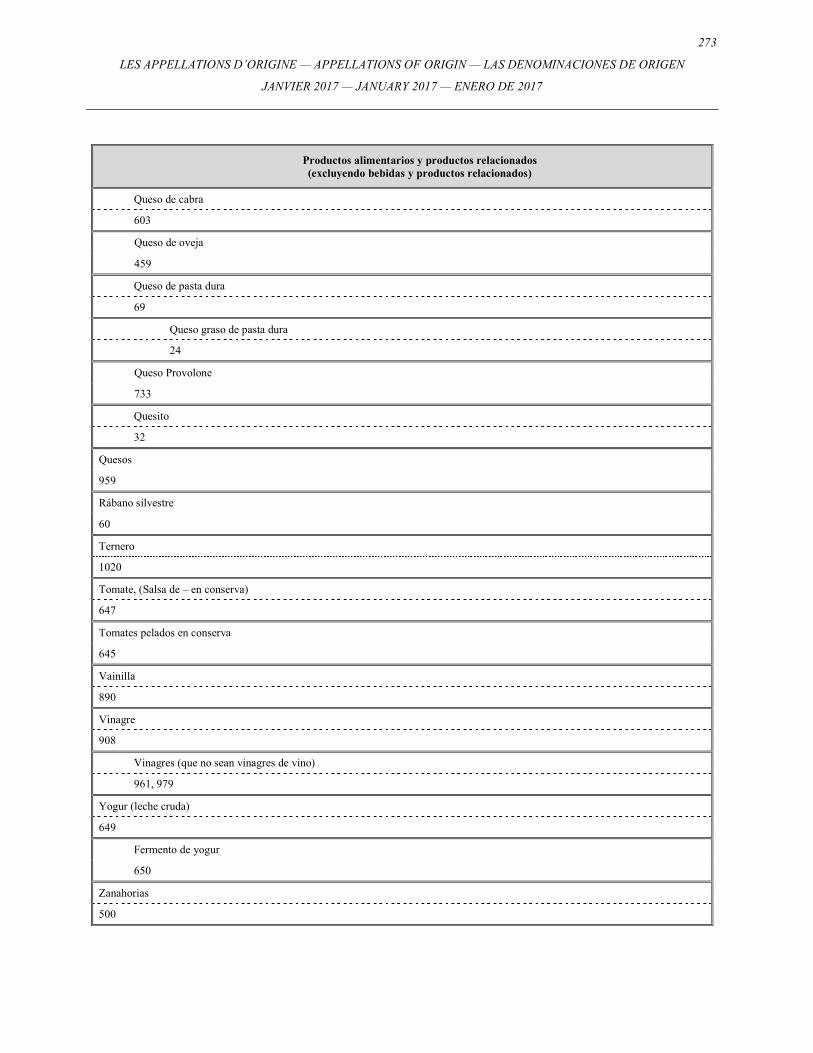
273
LES APPELLATIONS D’ORIGINE — APPELLATIONS OF ORIGIN — LAS DENOMINACIONES DE ORIGEN
JANVIER 2017 — JANUARY 2017 — ENERO DE 2017
Productos alimentarios y productos relacionados (excluyendo bebidas y productos relacionados)
Queso de cabra
603
Queso de oveja
459
Queso de pasta dura
69
Queso graso de pasta dura
24
Queso Provolone
733
Quesito
32
Quesos
959
Rábano silvestre
60
Ternero
1020
Tomate, (Salsa de – en conserva)
647
Tomates pelados en conserva
645
Vainilla
890
Vinagre
908
Vinagres (que no sean vinagres de vino)
961, 979
Yogur (leche cruda)
649
Fermento de yogur
650
Zanahorias
500
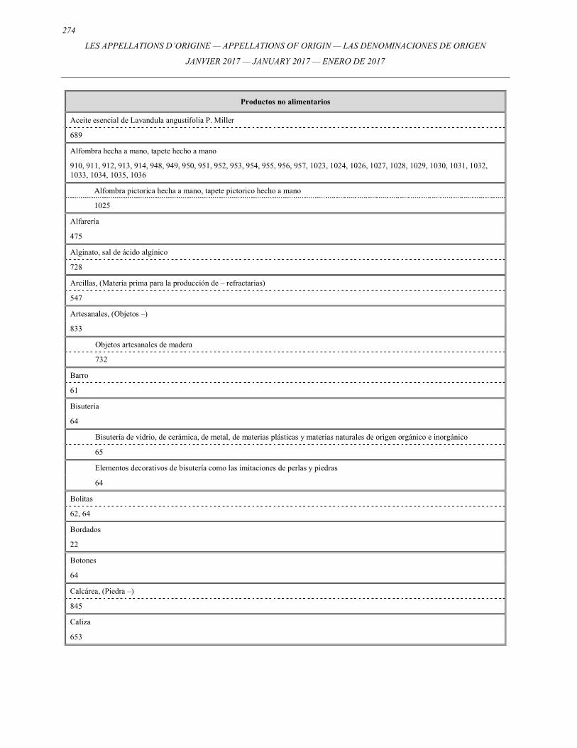
274
LES APPELLATIONS D’ORIGINE — APPELLATIONS OF ORIGIN — LAS DENOMINACIONES DE ORIGEN
JANVIER 2017 — JANUARY 2017 — ENERO DE 2017
Productos no alimentarios
Aceite esencial de Lavandula angustifolia P. Miller
689
Alfombra hecha a mano, tapete hecho a mano
910, 911, 912, 913, 914, 948, 949, 950, 951, 952, 953, 954, 955, 956, 957, 1023, 1024, 1026, 1027, 1028, 1029, 1030, 1031, 1032, 1033, 1034, 1035, 1036
Alfombra pictorica hecha a mano, tapete pictorico hecho a mano
1025
Alfarería
475
Alginato, sal de ácido algínico
728
Arcillas, (Materia prima para la producción de – refractarias)
547
Artesanales, (Objetos –)
833
Objetos artesanales de madera
732
Barro
61
Bisutería
64
Bisutería de vidrio, de cerámica, de metal, de materias plásticas y materias naturales de origen orgánico e inorgánico
65
Elementos decorativos de bisutería como las imitaciones de perlas y piedras
64
Bolitas
62, 64
Bordados
22
Botones
64
Calcárea, (Piedra –)
845
Caliza
653
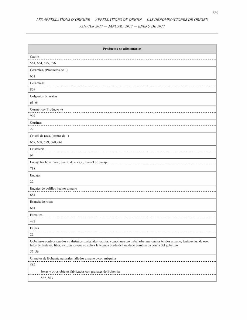
275
LES APPELLATIONS D’ORIGINE — APPELLATIONS OF ORIGIN — LAS DENOMINACIONES DE ORIGEN
JANVIER 2017 — JANUARY 2017 — ENERO DE 2017
Productos no alimentarios
Caolín
561, 654, 655, 656
Cerámica, (Productos de –)
651
Cerámicas
869
Colgantes de arañas
63, 64
Cosmético (Producto –)
907
Cortinas
22
Cristal de roca, (Arena de –)
657, 658, 659, 660, 661
Cristalería
64
Encaje hecho a mano, cuello de encaje, mantel de encaje
738
Encajes
22
Encajes de bolillos hechos a mano
684
Esencia de rosas
681
Esmaltes
472
Felpas
22
Gobelinos confeccionados en distintos materiales textiles, como lanas no trabajadas, materiales tejidos a mano, lentejuelas, de oro, hilos de fantasía, líber, etc., en los que se aplica la técnica burda del anudado combinada con la del gobelino
55, 56
Granates de Bohemia naturales tallados a mano o con máquina
562
Joyas y otros objetos fabricados con granates de Bohemia
562, 563
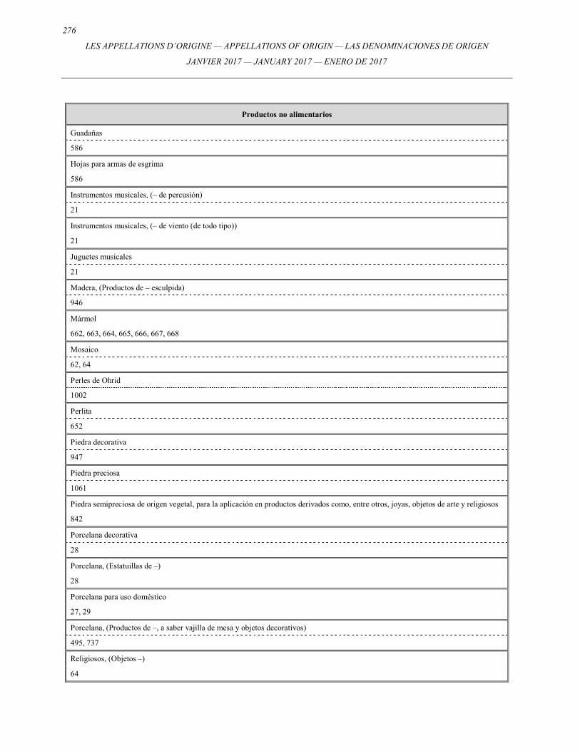
276
LES APPELLATIONS D’ORIGINE — APPELLATIONS OF ORIGIN — LAS DENOMINACIONES DE ORIGEN
JANVIER 2017 — JANUARY 2017 — ENERO DE 2017
Productos no alimentarios
Guadañas
586
Hojas para armas de esgrima
586
Instrumentos musicales, (– de percusión)
21
Instrumentos musicales, (– de viento (de todo tipo))
21
Juguetes musicales
21
Madera, (Productos de – esculpida)
946
Mármol
662, 663, 664, 665, 666, 667, 668
Mosaico
62, 64
Perles de Ohrid
1002
Perlita
652
Piedra decorativa
947
Piedra preciosa
1061
Piedra semipreciosa de origen vegetal, para la aplicación en productos derivados como, entre otros, joyas, objetos de arte y religiosos
842
Porcelana decorativa
28
Porcelana, (Estatuillas de –)
28
Porcelana para uso doméstico
27, 29
Porcelana, (Productos de –, a saber vajilla de mesa y objetos decorativos)
495, 737
Religiosos, (Objetos –)
64
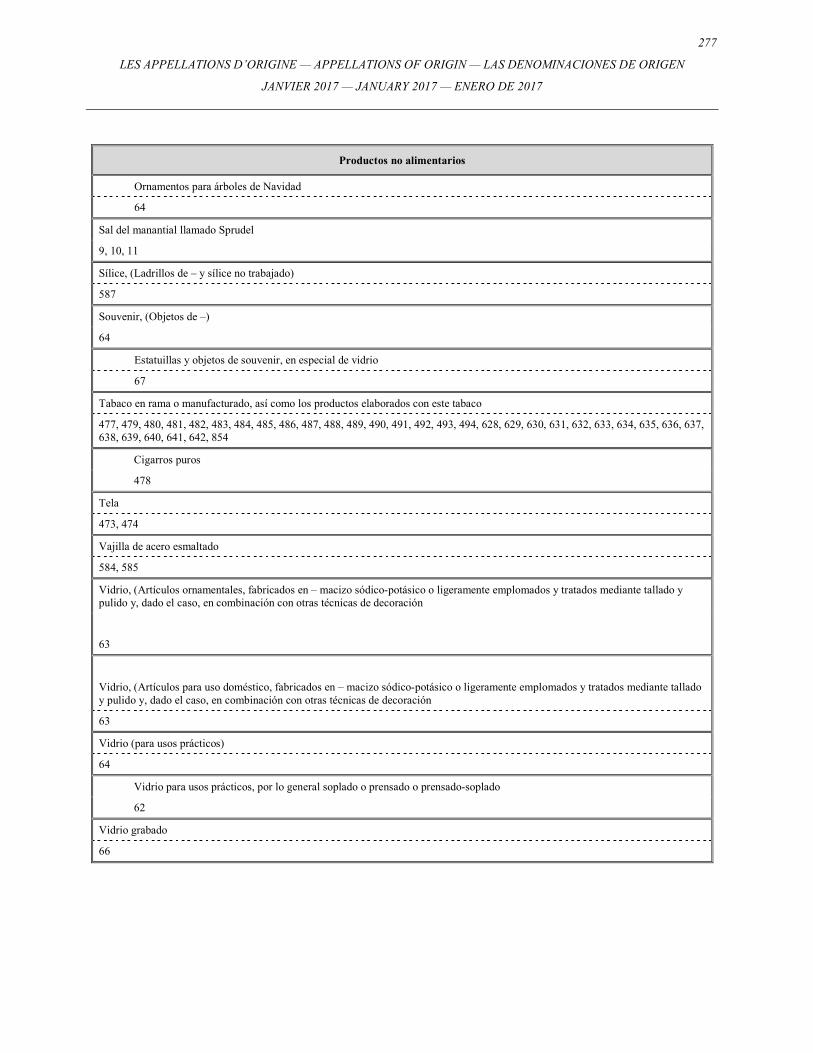
277
LES APPELLATIONS D’ORIGINE — APPELLATIONS OF ORIGIN — LAS DENOMINACIONES DE ORIGEN
JANVIER 2017 — JANUARY 2017 — ENERO DE 2017
Productos no alimentarios
Ornamentos para árboles de Navidad
64
Sal del manantial llamado Sprudel
9, 10, 11
Sílice, (Ladrillos de – y sílice no trabajado)
587
Souvenir, (Objetos de –)
64
Estatuillas y objetos de souvenir, en especial de vidrio
67
Tabaco en rama o manufacturado, así como los productos elaborados con este tabaco
477, 479, 480, 481, 482, 483, 484, 485, 486, 487, 488, 489, 490, 491, 492, 493, 494, 628, 629, 630, 631, 632, 633, 634, 635, 636, 637, 638, 639, 640, 641, 642, 854
Cigarros puros
478
Tela
473, 474
Vajilla de acero esmaltado
584, 585
Vidrio, (Artículos ornamentales, fabricados en – macizo sódico-potásico o ligeramente emplomados y tratados mediante tallado y pulido y, dado el caso, en combinación con otras técnicas de decoración
63
Vidrio, (Artículos para uso doméstico, fabricados en – macizo sódico-potásico o ligeramente emplomados y tratados mediante tallado y pulido y, dado el caso, en combinación con otras técnicas de decoración
63
Vidrio (para usos prácticos)
64
Vidrio para usos prácticos, por lo general soplado o prensado o prensado-soplado
62
Vidrio grabado
66
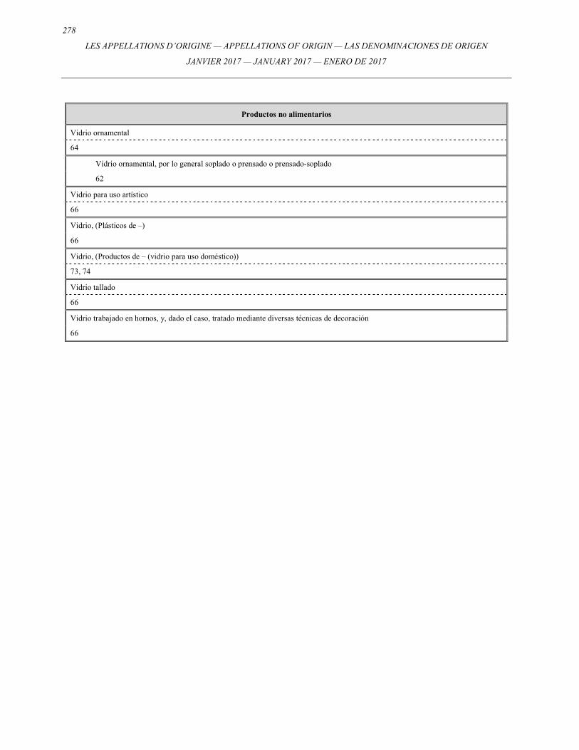
278
LES APPELLATIONS D’ORIGINE — APPELLATIONS OF ORIGIN — LAS DENOMINACIONES DE ORIGEN
JANVIER 2017 — JANUARY 2017 — ENERO DE 2017
Productos no alimentarios
Vidrio ornamental
64
Vidrio ornamental, por lo general soplado o prensado o prensado-soplado
62
Vidrio para uso artístico
66
Vidrio, (Plásticos de –)
66
Vidrio, (Productos de – (vidrio para uso doméstico))
73, 74
Vidrio tallado
66
Vidrio trabajado en hornos, y, dado el caso, tratado mediante diversas técnicas de decoración
66
Les appellations d’origineAppellations of origin
Las denominaciones de origen
No 39Janvier 2011 / January 2011 / Enero de 2011
Publication Date: February 10, 2005
Fecha de publicación: 10 de febrero de 2005
Nos 838979 - 839219
Les appellations d’origine
Publication du Bureau international de l’Organisation Mondiale de la Propriété IntellectuelleNo 45 - Janvier 2017
Appellations of origin
Publication of the International Bureau of the World Intellectual Property OrganizationNo. 45 - January 2017
Las denominaciones de origen
Publicación de la Oficina Internacional de la Organización Mundial de la Propiedad IntelectualNo 45 - Enero de 2017
ISSN 2226-6399 OMPI 2017 PUB: 105
ORGANISATION MONDIALE DE LA PROPRIÉTÉ INTELLECTUELLE
WORLD INTELLECTUAL PROPERTY ORGANIZATION
ORGANIZACIÓN MUNDIAL DE LA PROPIEDAD INTELECTUAL