late roman fortifications in the leskovac basin in ... · 219 t he central part of the leskovac...
TRANSCRIPT
219
T he central part of the Leskovac basin comprisesthe South Morava river valley and the valleysof its tributaries, the Pusta Reka, Jablanica,
Veternica and the Vlasina, and is bordered by moun-tains which surround the entire area from the western,southern, eastern and, to a degree, the northern side.The mountain ranges of Radan and Pasja~a stretch tothe west, Goljak and Kukavica to the south, Bukovik,Kru{evica, Babi~ka Gora and Seli~evica to the eastand Dobri~ to the north, the peaks of which do notexceed a height of 1,500 m. The basin covers an areaof 2,250 km².
The region of the Leskovac basin was only Roma-nised in the 1st century AD. Its settlement followed twobasic routes – the occupation of the river terraces in thevalleys of the South Morava, Veternica, Jablanica and
the Pusta Reka and the settlement of the mountainousregions surrounding the mining areas. The contact zonesbetween these regions were less densely populated,judging by the distribution of the sites in the area of thebasin. The highest intensity of settlement was notedaround the river valleys, with the highest concentra-tion around the South Morava.1 In this area, at theentrance to the Grdeli~ka Klisura (Grdelica Gorge) inMala Kopa{nica, was the largest Roman settlement inthis area, covering approximately 20 ha. The only vicuswith an unknown name was noted on a votive reliefdedicated to Liber from the village of Pusto [ilovo.2
LATE ROMAN FORTIFICATIONS IN THE LESKOVAC BASIN
IN RELATION TO URBAN CENTRES
VUJADIN IVANI[EVI], Institute of Archaeology, Belgrade
SONJA STAMENKOVI], Institute of Archaeology, Belgrade
UDK: 904:623.1"652"(497.11) ; 904:711.42"653"(497.11) DOI: 10.2298/STA1464219I
Short communication
e-mail: [email protected]
Received: February 17, 2014Accepted: July 23, 2014
Abstract. – Due to a general insecurity and the need to protect the population and communications, towards the end of the 4th century a large number of Late Roman fortifications were built in the region of the Leskovac basin, mainly towards the edges. Their distribution was determined by the level of the region’s population density, its resources and by the need to
control the roads. These were predominantly smaller fortifications whose primary role was the protection of the local population,who lived off the land and bred cattle. However, the largest number of these is in the western part of the basin, in the mountainous
regions of Goljak, Majdan, Radan and Pasja~a, whilst the highest density of fortifications is in the Banjska Reka valley, around the village of Sijarina. The whole region was known for its mining activity in previous centuries. A particular group
comprises the fortifications around Cari~in Grad – Justiniana Prima, whose main role was the defence of the access to the city.
Key words. – Leskovac basin, Late Antiquity, fortifications, economy, Cari~in Grad, Justiniana Prima.
1 Stamenkovi} 2013, 36.2 Stamenkovi} 2013, 54–55, sl. 40.
* The article results from the project: Urbanisation Processes and Development of Mediaeval Society (no. 177021), funded by the Ministryof Education, Science and Technological Development of the Republic of Serbia.
The whole area gravitated towards the distant Naissus,the closest key city, with most of this area officiallybelonging to the territory of Naissus.3
Towards the end of the 4th century, as a result ofthe barbarian invasions and their subsequent settling ofthe region of northern Illyricum, significant socio-eco-nomic turmoil started to occur, which was particularlyreflected in the changing roles of the settlements. Romanlowland settlements gave way to new fortified settle-ments on the dominant and well-guarded higher groundsabove the river valleys or in the mountainous regions.
Due to a general insecurity and the need to protectthe population and communications in the area of theLeskovac basin, a large number of Late Roman fortifi-
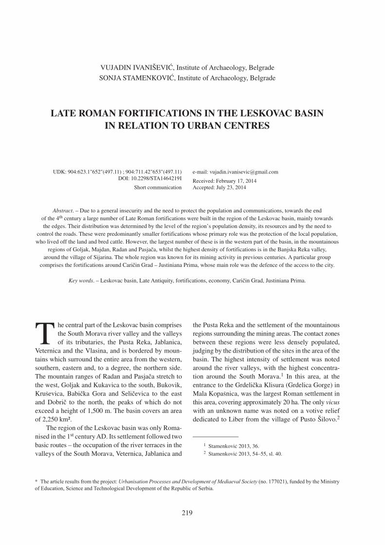
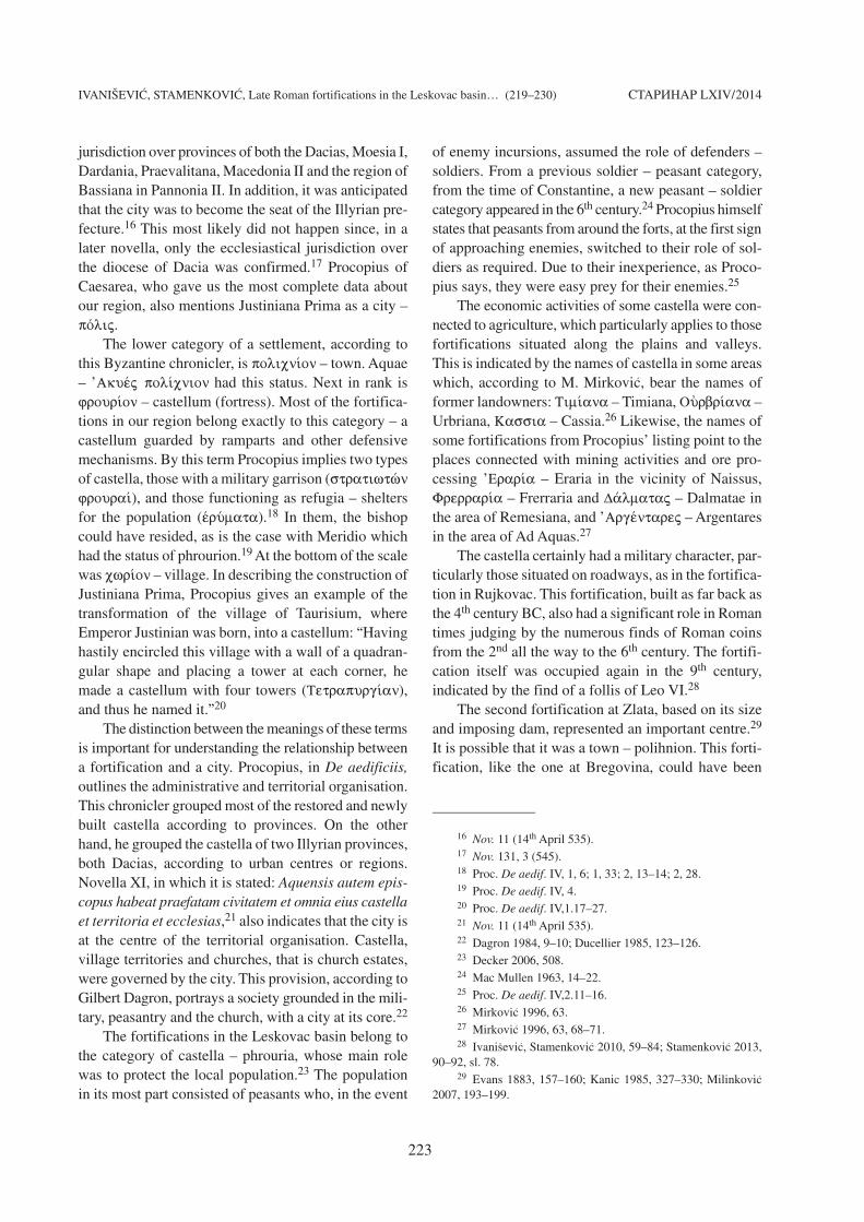
cations were built, mainly on the edges of the basin.Fortifications were erected on Radan along the riverbasins of the Lepa{tica, Lecka and Gazdarska Reka, onGoljak in the area around the rivers Tularska andBanjska Reka, around Cari~in Grad, in the area aroundRujkovac and Radinovac, and in the valleys of the[umanska Reka, Pusta Reka, Jablanica and Veternica.The slopes of Kukavica, the South Morava river val-ley, the complex around the Kozara~ka Reka, that isthe Rupska Reka, the lower course of the Vlasina, the
IVANI[EVI], STAMENKOVI], Late Roman fortifications in the Leskovac basin… (219–230) STARINAR LXIV/2014
220
Map 1. The Late Roman fortifications in the Leskovac basin
Karta 1. Kasnoanti~ka utvr|ewa u Leskova~koj kotlini
1. Gornji Gajtan, Sokolov Vis; 2. Miljkovica; 3. Pesti{–Bukoloram; 4. Mali Kamen; 5. Gornji Statovac, Mlinarov Kr{; 6. Bu~ince; 7. Arbana{ka;8. Rgaje, Grad; 9. Velika Braina, Brainski vis; 10. Gubavce, Gradina; 11. Mrkonje, Mrkonjski Vis; 12. Ma}edonce, Crkvi{te; 13. Vrapce, on thebank of the Tularska Reke; 14. Sijarinska Banja; 15. Sijarina, Gradina I; 16. Sijarina, Gradina II; 17. Svirce; 18. Zbe`i{te, Kopriva; 19. Zbe`i{te,Skobalji} Grad; 20. Pade`; 21. Gradi{te, Gradac; 22. Samarnica, Visoki Mori~; 23. Dedina Bara; 24. Novo Selo, Leskova Padina; 25. Grdelica, Kale;26. Svo|e, confluence of the Lu`nica and the Vlasina; 27. Zlati}evo, Prokop–Rimski Grad; 28. Gornji Prisjan; 29. Gornja Loko{nica, Gradi{te;30. Golema Njiva, Gradi{te; 31. Golema Njiva, Le{je; 32. Stupnica, ^ukar; 33. Crna Bara, Gradac or Rsa; 34. Grada{nica, Gradac or Gradi{te;35. Bregovina, Kale; 36. Marino Kale; 37. Braj{orski Vis; 38. Lece, Kuline; 39. [tulac, St. Elias; 40. Prekop~elica, Jezero; 41. Sekicol, Gradi{te;42. Svinjarica, Gornje Gradi{te; 43. Rujkovac, Kaljaja; 44. confluence of the Zabr|ski Potok and the Lapa{tica; 45. Popovac, Gradi{te; 46. Lapotince,south–east of the village; 47. Gornje Brijanje, Kale; 48. Me|a, Gradi{te; 49. Me|a, Kuli{te; 50. Kutle{, [iljegarnik; 51. Zlata, Kale; 52. Lipovica,Kuli{te; 53. Priboj, Gradi{te; 54. Leskovac, Hisar; 55. Konopnica, Gradac; 56. Konopnica, Latinsko (Cigansko) Groblje or Ciganski ^ukar.
3 Petrovi} 1976, 89.
IVANI[EVI], STAMENKOVI], Late Roman fortifications in the Leskovac basin… (219–230) STARINAR LXIV/2014
221
slopes of Babi~ka Gora and Kru{evica, and the conflu-ence of the Lu`nica and the Vlasina, were also fortified.4
Most of these fortifications were built on the highergrounds that dominate the wider surroundings (Map 1).
Chronological determination of the fortifications,based on the archaeological and numismatic material,was possible to a certain degree. Coins from the 4th
century were discovered within a large number of for-tifications such as those in Lece, Rujkovac, on Hisar inLeskovac, Stupnica, Grdelica and Skobalji} Grad nearVu~je. The circulation of coins in the 5th century wastestified to in Rujkovac, which represents importantproof of its survival during these turbulent times.5 Thedating of the fortifications into the 6th century is notonly supported by the coin finds but also by other archa-eological material, primarily ceramic vessels.6 Into thisperiod were also classified most of the fortificationslocated in Sijarina, Mrkonje, on Mali Kamen, in Rujko-vac, Gornje Brijanje, Gornja Loko{nica, Grada{nica,Konopnica, Gradi{te, on Hisar in Leskovac and Grde-lica. In a small number of fortifications, mainly thosewhere archaeological excavations have been carriedout, such as in Lece, Sijarinska Banja, Rujkovac, on
Hisar in Leskovac, Konopnica and Grdelica, horizonsfrom the 4th and 6th centuries have been confirmed.
The anthropogeographic features of the area, theeconomic resources in particular, played a significantrole in the settlement of the Leskovac basin. Most ofall, the river valleys stand out, the South Morava in par-ticular, as well as the Veternica, Jablanica, Pusta Rekaand Toplica, as being suitable for agricultural productionand wheat cultivation. It is worth remembering thatannona represented the foundation of the economy forurban and rural populations.7 On the other hand, thefoot hills on the margins of the Leskovac basin weresuited to cattle breeding. Viticulture was also present asone of the most important cultures of that time, judgingby the finds of stone winepresses from Vrbovac,8 inthe vicinity of Cari~in Grad and grape seeds at Cari~in
4 Stamenkovi} 2013, 23, map 6.5 Ivani{evi}, Stamenkovi} 2010, 59–84.6 Stamenkovi} 2013, 119–122.7 Morrisson, Sodini, 2002, 196.8 Stamenkovi} 2013, 58–59, sl. 42.
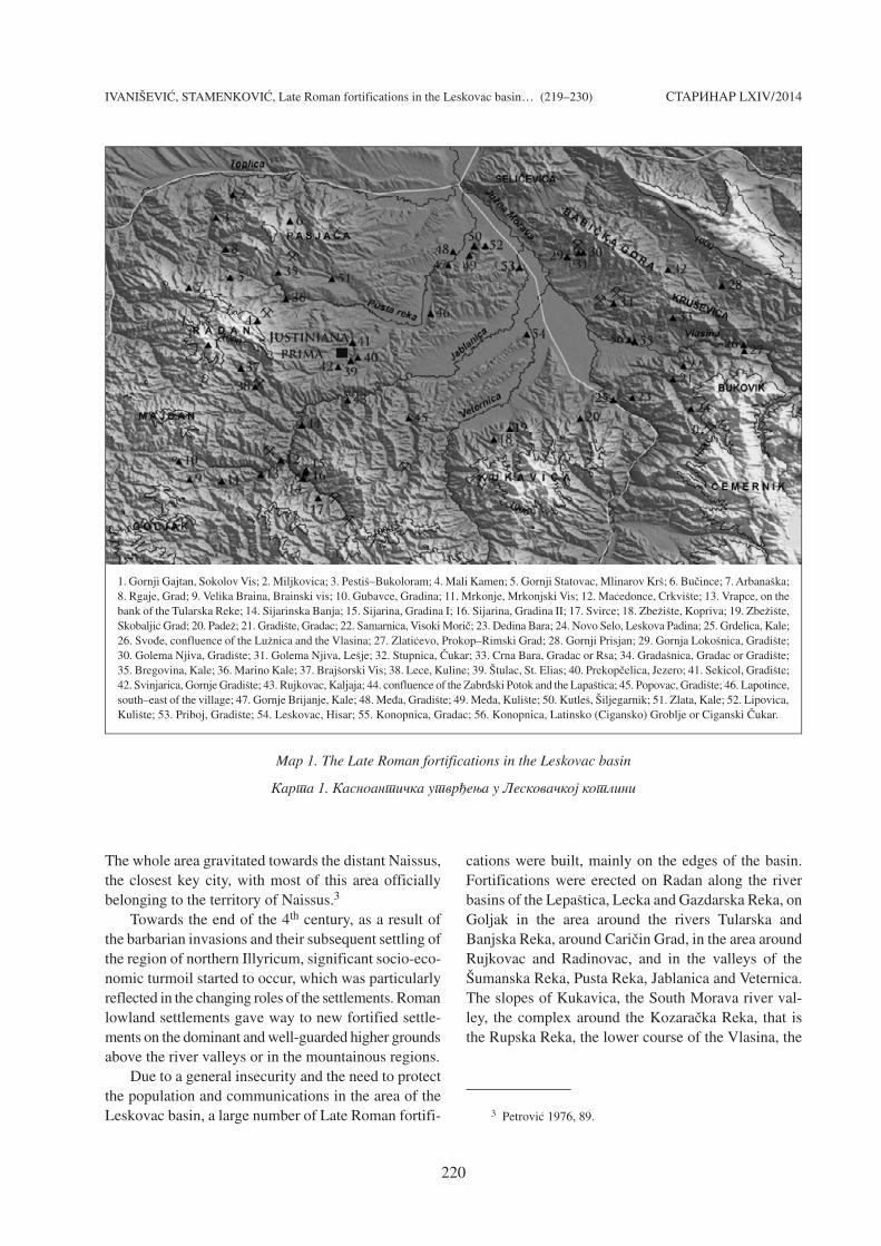
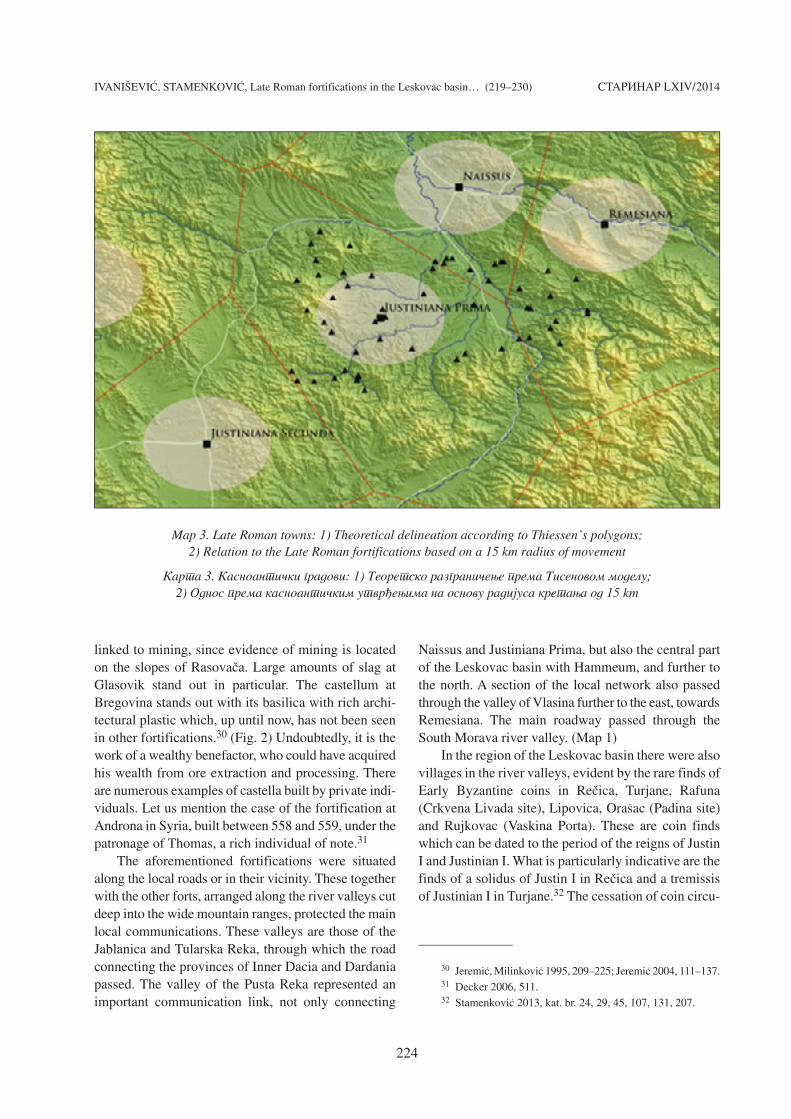
Map 2. The analysis of the spatial distribution of the Late Roman fortifications in the Leskovac basin
Karta 2. Analiza prostornog raspored kasnoanti~kih utvr|ewa u Leskova~koj kotlini
IVANI[EVI], STAMENKOVI], Late Roman fortifications in the Leskovac basin… (219–230)
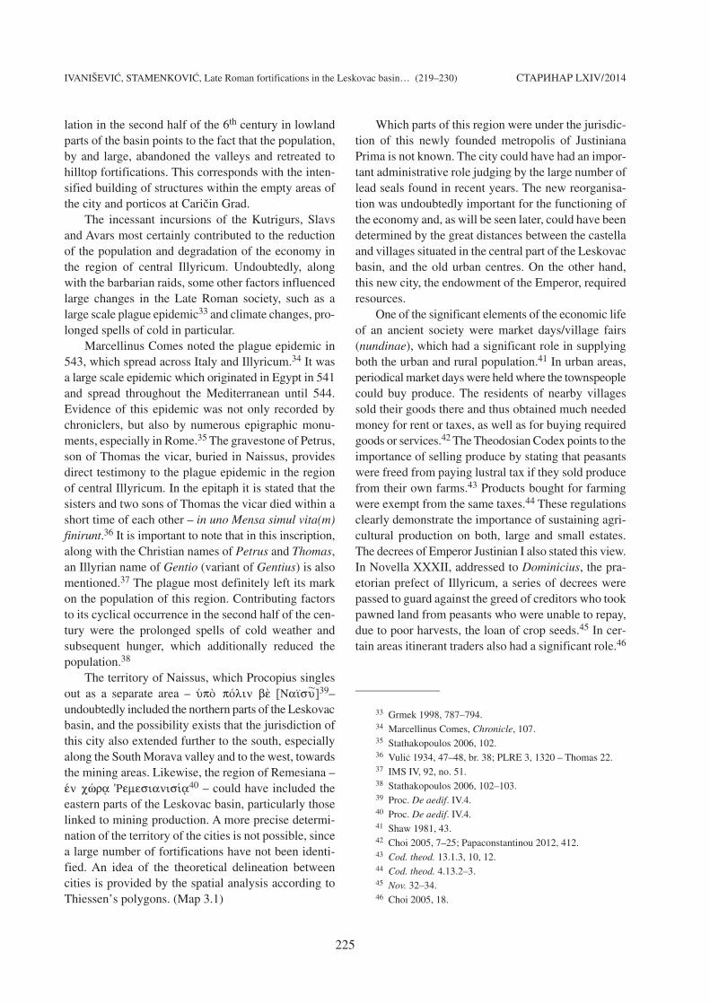
Grad. It is quite certain that in this area, as indicated bythe numerous remains of different kinds of grain andfruit at Cari~in Grad, other agricultural produce was alsogrown. In Roman times this territory was distinctive forits mining, the traces of which were confirmed in thewestern and north-western parts of the basin, on Goljak,Radan, Majdan, Pasja~a, in the wider area of Lece, inthe region around the Banjska Reka, in Ravna Banja andMarovac, as well as in the eastern and north-easternparts of the basin, in the region of Ruplje and on theslopes of Babi~ka Gora and Kru{evica.9
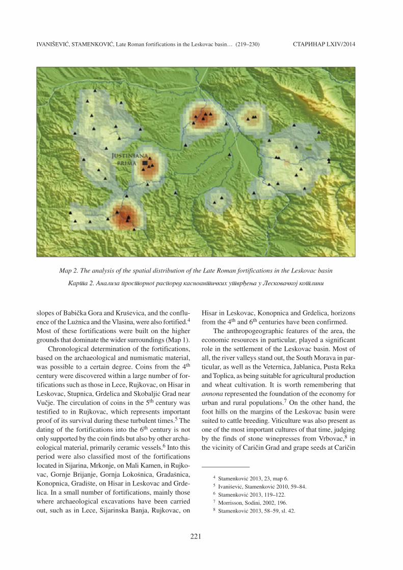
As evidence of mining, mine shafts, smelting com-plexes and slag heaps are singled out. Roman mineshafts were recorded on Rasova~a, which is well-knownfor deposits of gold, sulphides of lead, copper and silver,and semi-precious stones (amethyst, opal and agate).10
(Fig. 1) They are also testified to in Ravna Banja andMarovac, where remnants of a smelting complex and aslag heap have been confirmed. In Roman times, minesin the far east of the basin were also in use, in the areaof Ruplje, where silver, lead and gold were mined, aswell as in the region of Crna Trava, well known foriron ore. Not far from here, important material proof ofore processing was found,11 in the form of an iron ingotfrom the Visoki Mori~ site in Samarnica.12 In additionto the obvious traces of Roman mining, a significantcontribution to the evidence of this activity are the epi-graphic monuments found in the area of the Leskovacbasin, given that the most frequently occurring deitieson them are Hercules and Liber who have been attribu-ted with, among other things, the role of protectingmines and mining activity.13
The distribution of the Late Roman fortifications,as is the case with the Roman settlements, was deter-mined by the level of the region’s population density,its resources and the need to control the roadways.Analysis of the position of the fortifications indicatesa concentration of forts on the higher grounds whichsurround the river valleys of the South Morava and itstributaries. Their highest density is found on the slopesof Dobra Gora, situated between the valleys of thePusta Reka, Jablanica and the South Morava. Theseare mainly smaller fortifications whose primary rolewas to protect the local population, which was mostcertainly engaged in agriculture. However, the largestnumber of these forts is located in the western part ofthe basin, in the mountainous regions of Goljak,Majdan, Radan and Pasja~a. The highest density of thefortifications is in the valley of the Banjska Reka,around Sijarina.14 (Map 2)
The entire area was well known for mining in pre-vious centuries. The re-establishment of mining activityduring the 6th century should not be excluded as a pos-sibility. A separate group is comprised of a smallercluster of fortifications located around Cari~in Grad –Justiniana Prima, whose predominant role was to guardthe access to the city.15
Justiniana Prima represents the only city – pÒlij
erected in around 535 in the centre of this region, as theseat of the archbishop ('Illurièn £rciereÚj) with
STARINAR LXIV/2014
222
9 Stamenkovi} 2013, 86–96.10 Pe{ut 1976, 33.11 Stamenkovi} 2013, 66–67, 86–89.12 Stamenkovi} 2013, 88, sl. 75.13 Du{ani} 1999, 130–135; Stamenkovi} 2013, 95–98.14 Stamenkovi} 2013, map 5.15 Kondi}, Popovi} 1977; Bavant, Ivani{evi} 2003.
Fig. 1. Rasova~a – Roman mine shaft
Sl. 1. Rasova~a – Rimsko okno
IVANI[EVI], STAMENKOVI], Late Roman fortifications in the Leskovac basin… (219–230) STARINAR LXIV/2014
223
jurisdiction over provinces of both the Dacias, Moesia I,Dardania, Praevalitana, Macedonia II and the region ofBassiana in Pannonia II. In addition, it was anticipatedthat the city was to become the seat of the Illyrian pre-fecture.16 This most likely did not happen since, in alater novella, only the ecclesiastical jurisdiction overthe diocese of Dacia was confirmed.17 Procopius ofCaesarea, who gave us the most complete data aboutour region, also mentions Justiniana Prima as a city –pÒlij.
The lower category of a settlement, according tothis Byzantine chronicler, is policn/on – town. Aquae– ’Akušj pol/cnion had this status. Next in rank isfrour/on – castellum (fortress). Most of the fortifica-tions in our region belong exactly to this category – acastellum guarded by ramparts and other defensivemechanisms. By this term Procopius implies two typesof castella, those with a military garrison (stratiwtèn
froura/), and those functioning as refugia – sheltersfor the population (šrÚmata).18 In them, the bishopcould have resided, as is the case with Meridio whichhad the status of phrourion.19 At the bottom of the scalewas cwr/on – village. In describing the construction ofJustiniana Prima, Procopius gives an example of thetransformation of the village of Taurisium, whereEmperor Justinian was born, into a castellum: “Havinghastily encircled this village with a wall of a quadran-gular shape and placing a tower at each corner, hemade a castellum with four towers (Tetrapurg/an),and thus he named it.”20
The distinction between the meanings of these termsis important for understanding the relationship betweena fortification and a city. Procopius, in De aedificiis,outlines the administrative and territorial organisation.This chronicler grouped most of the restored and newlybuilt castella according to provinces. On the otherhand, he grouped the castella of two Illyrian provinces,both Dacias, according to urban centres or regions.Novella XI, in which it is stated: Aquensis autem epis-copus habeat praefatam civitatem et omnia eius castellaet territoria et ecclesias,21 also indicates that the city isat the centre of the territorial organisation. Castella,village territories and churches, that is church estates,were governed by the city. This provision, according toGilbert Dagron, portrays a society grounded in the mili-tary, peasantry and the church, with a city at its core.22
The fortifications in the Leskovac basin belong tothe category of castella – phrouria, whose main rolewas to protect the local population.23 The populationin its most part consisted of peasants who, in the event
of enemy incursions, assumed the role of defenders –soldiers. From a previous soldier – peasant category,from the time of Constantine, a new peasant – soldiercategory appeared in the 6th century.24 Procopius himselfstates that peasants from around the forts, at the first signof approaching enemies, switched to their role of sol-diers as required. Due to their inexperience, as Proco-pius says, they were easy prey for their enemies.25
The economic activities of some castella were con-nected to agriculture, which particularly applies to thosefortifications situated along the plains and valleys.This is indicated by the names of castella in some areaswhich, according to M. Mirkovi}, bear the names offormer landowners: Tim/ana – Timiana, OÙrbr/ana –Urbriana, Kassia – Cassia.26 Likewise, the names ofsome fortifications from Procopius’ listing point to theplaces connected with mining activities and ore pro-cessing ’Erar/a – Eraria in the vicinity of Naissus,Frerrar/a – Frerraria and D£lmataj – Dalmatae inthe area of Remesiana, and ’Argšntarej – Argentaresin the area of Ad Aquas.27
The castella certainly had a military character, par-ticularly those situated on roadways, as in the fortifica-tion in Rujkovac. This fortification, built as far back asthe 4th century BC, also had a significant role in Romantimes judging by the numerous finds of Roman coinsfrom the 2nd all the way to the 6th century. The fortifi-cation itself was occupied again in the 9th century,indicated by the find of a follis of Leo VI.28
The second fortification at Zlata, based on its sizeand imposing dam, represented an important centre.29
It is possible that it was a town – polihnion. This forti-fication, like the one at Bregovina, could have been
16 Nov. 11 (14th April 535).17 Nov. 131, 3 (545).18 Proc. De aedif. IV, 1, 6; 1, 33; 2, 13–14; 2, 28.19 Proc. De aedif. IV, 4.20 Proc. De aedif. IV,1.17–27.21 Nov. 11 (14th April 535).22 Dagron 1984, 9–10; Ducellier 1985, 123–126.23 Decker 2006, 508.24 Mac Mullen 1963, 14–22.25 Proc. De aedif. IV,2.11–16. 26 Mirkovi} 1996, 63. 27 Mirkovi} 1996, 63, 68–71.28 Ivani{evi}, Stamenkovi} 2010, 59–84; Stamenkovi} 2013,
90–92, sl. 78.29 Evans 1883, 157–160; Kanic 1985, 327–330; Milinkovi}
2007, 193–199.
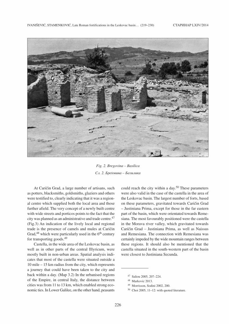
linked to mining, since evidence of mining is locatedon the slopes of Rasova~a. Large amounts of slag atGlasovik stand out in particular. The castellum atBregovina stands out with its basilica with rich archi-tectural plastic which, up until now, has not been seenin other fortifications.30 (Fig. 2) Undoubtedly, it is thework of a wealthy benefactor, who could have acquiredhis wealth from ore extraction and processing. Thereare numerous examples of castella built by private indi-viduals. Let us mention the case of the fortification atAndrona in Syria, built between 558 and 559, under thepatronage of Thomas, a rich individual of note.31
The aforementioned fortifications were situatedalong the local roads or in their vicinity. These togetherwith the other forts, arranged along the river valleys cutdeep into the wide mountain ranges, protected the mainlocal communications. These valleys are those of theJablanica and Tularska Reka, through which the roadconnecting the provinces of Inner Dacia and Dardaniapassed. The valley of the Pusta Reka represented animportant communication link, not only connecting
Naissus and Justiniana Prima, but also the central partof the Leskovac basin with Hammeum, and further tothe north. A section of the local network also passedthrough the valley of Vlasina further to the east, towardsRemesiana. The main roadway passed through theSouth Morava river valley. (Map 1)
In the region of the Leskovac basin there were alsovillages in the river valleys, evident by the rare finds ofEarly Byzantine coins in Re~ica, Turjane, Rafuna(Crkvena Livada site), Lipovica, Ora{ac (Padina site)and Rujkovac (Vaskina Porta). These are coin findswhich can be dated to the period of the reigns of JustinI and Justinian I. What is particularly indicative are thefinds of a solidus of Justin I in Re~ica and a tremissisof Justinian I in Turjane.32 The cessation of coin circu-
30 Jeremi}, Milinkovi} 1995, 209–225; Jeremi} 2004, 111–137.31 Decker 2006, 511.32 Stamenkovi} 2013, kat. br. 24, 29, 45, 107, 131, 207.
IVANI[EVI], STAMENKOVI], Late Roman fortifications in the Leskovac basin… (219–230) STARINAR LXIV/2014
224
Map 3. Late Roman towns: 1) Theoretical delineation according to Thiessen’s polygons; 2) Relation to the Late Roman fortifications based on a 15 km radius of movement
Karta 3. Kasnoanti~ki gradovi: 1) Teoretsko razgrani~ewe prema Tisenovom modelu; 2) Odnos prema kasnoanti~kim utvr|ewima na osnovu radijusa kretawa od 15 km
lation in the second half of the 6th century in lowlandparts of the basin points to the fact that the population,by and large, abandoned the valleys and retreated tohilltop fortifications. This corresponds with the inten-sified building of structures within the empty areas ofthe city and porticos at Cari~in Grad.
The incessant incursions of the Kutrigurs, Slavsand Avars most certainly contributed to the reductionof the population and degradation of the economy inthe region of central Illyricum. Undoubtedly, alongwith the barbarian raids, some other factors influencedlarge changes in the Late Roman society, such as alarge scale plague epidemic33 and climate changes, pro-longed spells of cold in particular.
Marcellinus Comes noted the plague epidemic in543, which spread across Italy and Illyricum.34 It wasa large scale epidemic which originated in Egypt in 541and spread throughout the Mediterranean until 544.Evidence of this epidemic was not only recorded bychroniclers, but also by numerous epigraphic monu-ments, especially in Rome.35 The gravestone of Petrus,son of Thomas the vicar, buried in Naissus, providesdirect testimony to the plague epidemic in the regionof central Illyricum. In the epitaph it is stated that thesisters and two sons of Thomas the vicar died within ashort time of each other – in uno Mensa simul vita(m)finirunt.36 It is important to note that in this inscription,along with the Christian names of Petrus and Thomas,an Illyrian name of Gentio (variant of Gentius) is alsomentioned.37 The plague most definitely left its markon the population of this region. Contributing factorsto its cyclical occurrence in the second half of the cen-tury were the prolonged spells of cold weather andsubsequent hunger, which additionally reduced thepopulation.38
The territory of Naissus, which Procopius singlesout as a separate area – ÚpÕ pÒlin b_ [Na=su
~]39–undoubtedly included the northern parts of the Leskovacbasin, and the possibility exists that the jurisdiction ofthis city also extended further to the south, especiallyalong the South Morava valley and to the west, towardsthe mining areas. Likewise, the region of Remesiana –šn cèrv 'Remesianis/v40 – could have included theeastern parts of the Leskovac basin, particularly thoselinked to mining production. A more precise determi-nation of the territory of the cities is not possible, sincea large number of fortifications have not been identi-fied. An idea of the theoretical delineation betweencities is provided by the spatial analysis according toThiessen’s polygons. (Map 3.1)
Which parts of this region were under the jurisdic-tion of this newly founded metropolis of JustinianaPrima is not known. The city could have had an impor-tant administrative role judging by the large number oflead seals found in recent years. The new reorganisa-tion was undoubtedly important for the functioning ofthe economy and, as will be seen later, could have beendetermined by the great distances between the castellaand villages situated in the central part of the Leskovacbasin, and the old urban centres. On the other hand,this new city, the endowment of the Emperor, requiredresources.
One of the significant elements of the economic lifeof an ancient society were market days/village fairs(nundinae), which had a significant role in supplyingboth the urban and rural population.41 In urban areas,periodical market days were held where the townspeoplecould buy produce. The residents of nearby villagessold their goods there and thus obtained much neededmoney for rent or taxes, as well as for buying requiredgoods or services.42 The Theodosian Codex points to theimportance of selling produce by stating that peasantswere freed from paying lustral tax if they sold producefrom their own farms.43 Products bought for farmingwere exempt from the same taxes.44 These regulationsclearly demonstrate the importance of sustaining agri-cultural production on both, large and small estates.The decrees of Emperor Justinian I also stated this view.In Novella XXXII, addressed to Dominicius, the pra-etorian prefect of Illyricum, a series of decrees werepassed to guard against the greed of creditors who tookpawned land from peasants who were unable to repay,due to poor harvests, the loan of crop seeds.45 In cer-tain areas itinerant traders also had a significant role.46
33 Grmek 1998, 787–794.34 Marcellinus Comes, Chronicle, 107.35 Stathakopoulos 2006, 102.36 Vuli} 1934, 47–48, br. 38; PLRE 3, 1320 – Thomas 22.37 IMS IV, 92, no. 51.38 Stathakopoulos 2006, 102–103.39 Proc. De aedif. IV.4.40 Proc. De aedif. IV.4. 41 Shaw 1981, 43.42 Choi 2005, 7–25; Papaconstantinou 2012, 412. 43 Cod. theod. 13.1.3, 10, 12.44 Cod. theod. 4.13.2–3.45 Nov. 32–34.46 Choi 2005, 18.
IVANI[EVI], STAMENKOVI], Late Roman fortifications in the Leskovac basin… (219–230) STARINAR LXIV/2014
225
IVANI[EVI], STAMENKOVI], Late Roman fortifications in the Leskovac basin… (219–230)
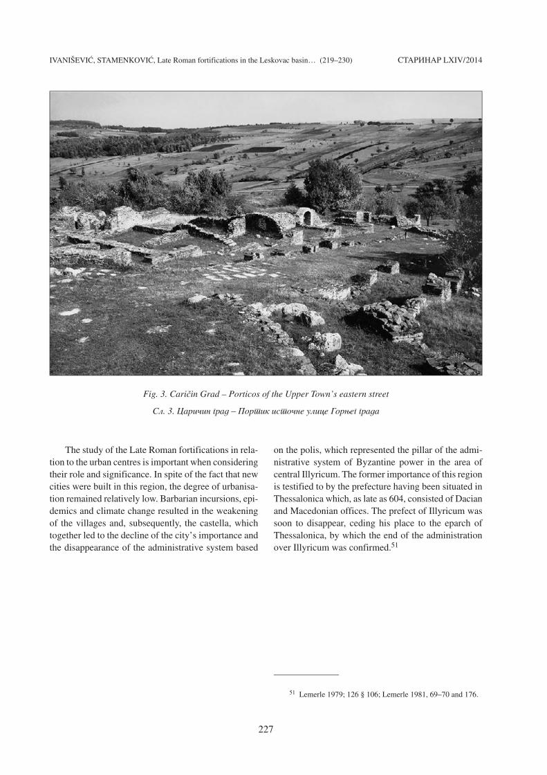
At Cari~in Grad, a large number of artisans, suchas potters, blacksmiths, goldsmiths, glaziers and otherswere testified to, clearly indicating that it was a region-al centre which supplied both the local area and thosefurther afield. The very concept of a newly built centrewith wide streets and porticos points to the fact that thecity was planned as an administrative and trade centre.47
(Fig.3) An indication of the lively local and regionaltrade is the presence of camels and mules at Cari~inGrad,48 which were particularly used in the 6th centuryfor transporting goods.49
Castella, in the wide area of the Leskovac basin, aswell as in other parts of the central Illyricum, weremostly built in non-urban areas. Spatial analysis indi-cates that most of the castella were situated outside a10 mile – 15 km radius from the city, which representsa journey that could have been taken to the city andback within a day. (Map 3.2) In the urbanised regionsof the Empire, in central Italy, the distance betweencities was from 11 to 13 km, which enabled strong eco-nomic ties. In Lower Galilee, on the other hand, peasants
could reach the city within a day.50 These parameterswere also valid in the case of the castella in the area ofthe Leskovac basin. The largest number of forts, basedon these parameters, gravitated towards Cari~in Grad– Justiniana Prima, except for those in the far easternpart of the basin, which were orientated towards Reme-siana. The most favourably positioned were the castellain the Morava river valley, which gravitated towardsCari~in Grad – Justiniana Prima, as well as Naissusand Remesiana. The connection with Remesiana wascertainly impeded by the wide mountain ranges betweenthese regions. It should also be mentioned that thecastella situated in the south-western part of the basinwere closest to Justiniana Secunda.
47 Saliou 2005, 207–224.48 Markovi} 2013.49 Morrisson, Sodini 2002, 200.50 Choi 2005, 11–12: with quoted literature.
STARINAR LXIV/2014
226
Fig. 2. Bregovina – Basilica
Sl. 2. Bregovina – Bazilika
IVANI[EVI], STAMENKOVI], Late Roman fortifications in the Leskovac basin… (219–230)
The study of the Late Roman fortifications in rela-tion to the urban centres is important when consideringtheir role and significance. In spite of the fact that newcities were built in this region, the degree of urbanisa-tion remained relatively low. Barbarian incursions, epi-demics and climate change resulted in the weakeningof the villages and, subsequently, the castella, whichtogether led to the decline of the city’s importance andthe disappearance of the administrative system based
on the polis, which represented the pillar of the admi-nistrative system of Byzantine power in the area ofcentral Illyricum. The former importance of this regionis testified to by the prefecture having been situated inThessalonica which, as late as 604, consisted of Dacianand Macedonian offices. The prefect of Illyricum wassoon to disappear, ceding his place to the eparch ofThessalonica, by which the end of the administrationover Illyricum was confirmed.51
51 Lemerle 1979; 126 § 106; Lemerle 1981, 69–70 and 176.
STARINAR LXIV/2014
227
Fig. 3. Cari~in Grad – Porticos of the Upper Town’s eastern street
Sl. 3. Cari~in grad – Portik isto~ne ulice Gorweg grada
IVANI[EVI], STAMENKOVI], Late Roman fortifications in the Leskovac basin… (219–230) STARINAR LXIV/2014
228
SOURCES:
Bavant, Ivani{evi} 2003 – B. Bavant, V. Ivani{evi},Ivstiniana Prima – Cari~in Grad, Beograd 2003.
Choi 2005 – A. Choi, The Travelling Peasant andUrban-Rural Relations in Roman Galilee, in: Traveland Religion in Antiquity. Canadian Society of BiblicalStudies Seminar, 2005. Available at http://www.philipharland.com/travelandreligion.htm (10th December2013).
Dagron 1984 – G. Dagron, Les villes dans l’Illyricumprotobyzantin, in: Villes et peuplement dans l’Illyricumprotobyzantin. Actes du colloque de Rome (12–14 mai1982), Rome, 1984, 1–20.
Decker 2006 – M. Decker, Towns, Refuges andFortified Farms in the Late Roman East, Liber Annus56, 2006, 499–520.
Ducellier 1985 – A. Ducellier, Le problème desautonomismes urbains dans les Balkans: origines, con-tinuités et ruptures (VIe–XIIIe siècles), In: Actes descongrès de la Société des historiens médiévistes del’enseignement supérieur public. 16e congrès, Rouen,1985, 121–141.
Du{ani} 1999 – S. Du{ani}, The Miners’ Cults inIllyricum, in: Mélanges C. Domergue, Pallas 50,Toulouse, 1999, 129–139.
Evans 1883 – A. J. Evans, Antiquarian researchesin Illyricum, parts I and II, Westminster 1883.
Grmek 1998 – M. Grmek, Les conséquences de lapeste de Justinien dans l’Illyricum, in: Radovi XIII me-|unarodnog kongresa za starokr{}ansku arheologiju, 2,(eds.) N. Cambi, E. Marin, Split 1998. 2, 787–794.
IMS IV – Inscription de la Mésie Supérieure IV.Naissus – Remesiana – Horreum Margi, (ed.) P. Petrovi},Belgrade 1979.
Ivani{evi}, Stamenkovi} 2010 – V. Ivani{evi}, S.Stamenkovi}, Nalazi novca 5. veka iz Rujkovca, Lesko-va~ki zbornik 50, 2010, 59–84.
Jeremi} 2004 – M. Jeremi}, Arhitektonska dekora-tivna plastika crkve u Bregovini, Starinar 53–54, 2004,111–137.
Jeremi}, Milinkovi} 1997 – M. Jeremi}, M. Milin-kovi}, Die Byzantinische Festung von Bregovina (Süd-serbien), Antiquité tardive III, Paris 1997, 209–225.
Kanic 1985 – F. Kanic, Srbija, zemlja i stanovni{tvo,2, Beograd 1985.
Kondi}, Popovi} 1977 – V. Kondi}, V. Popovi},Cari~in Grad, utvr|eni grad u vizantijskom Iliriku, Beo-grad 1977.
Lemerle 1979 – P. Lemerle, Les plus anciens recueilsdes miracles de saint Démétrius, I (texte et analyse),Paris, 1979.
Lemerle 1981 – P. Lemerle, Les plus anciensrecueils des miracles de saint Démétrius, II (commen-taire), Paris, 1981.
Mac Mullen 1963 – R. Mac Mullen, Soldier andCivilian in the Later Roman Empire, Cambridge Mass.,1963.
Markovi} 2013 – N. Markovi}, Promene u eksplo-ataciji `ivotinja na ranovizantijskom nalazi{tu Cari~ingrad: ostaci faune iz kompleksa jugoisto~ne ugaonekule Donjeg grada. Unpublished MA thesis, Faculty ofPhilosophy, Belgrade 2013.
McCormik et al. 2012 – M. McCormick, U.Büntgen, M. A. Cane, E. R. Cook, K. Harper, P. Huybers,T. Litt, S. W. Manning, P. A. Mayewski, A. F. M. More,K. Nicolussi, W. Tegel, Climate Change during andafter the Roman Empire: Reconstructing the Past from
BIBLIOGRAPHY:
Cod. theod. . . . . . . . . . . . . . . . . . . . . . . . . . . . . . . . . . .
Marcellinus Comes, Chronicle . . . . . . . . . . . . . . . . . . .
Nov. . . . . . . . . . . . . . . . . . . . . . . . . . . . . . . . . . . . . . . . . .
Proc. De aedif. . . . . . . . . . . . . . . . . . . . . . . . . . . . . . . . .
Codex Theodosianus, (ed.) Th. Mommsen, P. Meyer, Berlin 1905.The Chronicle of Marcellinus, (ed.) B. Croke. Sydney 1995.Corpus Iuris Civilis III. Novellae, (eds.) R. Schoell, G. Kroll, Berlin 1912.Procopii Caesarensis De Aedificiis, (ed.) J. Haury. Leipzig 1913.
IVANI[EVI], STAMENKOVI], Late Roman fortifications in the Leskovac basin… (219–230) STARINAR LXIV/2014
229
Scientific and Historical Evidence, Journal of Interdis-ciplinary History, 43:2 (Autumn, 2012), 169–220.
Milinkovi} 2007 – M. Milinkovi}, O potrebi nau~-nog prou~avanja lokaliteta Zlata–Kale, Ni{ i VizantijaV, 2007, 191–203.
Morrisson, Sodini 2002 – C. Morrisson, J.-P.Sodini, The Sixth-Century Economy, in: The EconomicHistory of Byzantium: From the Seventh through theFifteenth Century, (ed.) A. Laiou, Washington D.C. 2002,171–220.
Papaconstantinou 2012 – A. Papaconstantinou, Lespropriétaires ruraux en Palestine du sud et en Egypteentre la conquête perse et l’arrivée des Abbassides,Mélanges de l’École francaise de Rome – Moyen Âge124/2, 2012, 405–416.
Pe{ut 1976 – D. Pe{ut, Geolo{ki sastav, tektonskastruktura i metalogenija leckog andezitskog masiva,Rasprave Zavoda za geolo{ka i geofizi~ka istra`ivanjaXIV, Beograd 1976.
Petrovi} 1976 – P. Petrovi}, Ni{ u anti~ko doba,Ni{ 1976.
PLRE 3 – The Prosopography of the Later RomanEmpire, vol. 3, (ed.) J. R. Martindale, Cambridge 1992.
Saliou 2005 – C. Saliou, Identité culturelle et pay-sage urbain : remarques sur les processus de transfor-mation des rues à portiques dans l’Antiquité tardive,Syria 82, 2005, 207–224.
Shaw 1981 – B. Shaw, Rural markets in North Africaand the political economy of the Roman Empire, Anti-quités africaines 17,1981, 37–83.
Stamenkovi} 2013 – S. Stamenkovi}, Rimsko na-sle|e u Leskova~koj kotlini, Beograd 2013.
Stathakopoulos 2006 – D. Stathakopoulos, Crimeand Punishment: The Plague in the Byzantine Empire,541–749, in: Plague and the End of Antiquity, The Pande-mic of 541–750, (ed.) L. Little, Cambridge 2006, 99–118.
Vuli} 1934 – N. Vuli}, Anti~ki spomenici na{e zemlje,Spomenik, Srpske kraljevske akademije LXXVII, 1934,3–54.
IVANI[EVI], STAMENKOVI], Late Roman fortifications in the Leskovac basin… (219–230) STARINAR LXIV/2014
230
Krajem 4. veka, usled upada i naseqavawa Varvara na pod-ru~je severnog Ilirika, dolazi do velikih dru{tveno-eko-nomskih potresa, koji }e se posebno odraziti na promenuuloge naseqa. Rimska ravni~arska naseqa ustupaju mestonovim utvr|enim stani{tima podignutim na dominantnimi dobro brawenim visovima iznad re~nih dolina ili unu-tar planinskih oblasti.
Usled op{te nesigurnosti i potrebe za{tite stanov-ni{tva i komunikacija na podru~ju Leskova~ke kotline,podi`e se veliki broj kasnoanti~kih fortifikacija, ma-hom na rubovima kotline. Fortifikacije su podignute naRadanu, uz slivove Lepa{tice, Lecke i Gazdarske reke, Go-qaku, sa podru~jem oko Tularske i Bawske reke, oko Cari-~inog grada, oblasti oko Rujkovca i Radinovca, zatim u do-lini [umanske reke, Puste reke, Jablanice i Veternice.Fortificirani su i pobr|a Kukavice, dolina Ju`ne Mo-rave, kompleks oko Kozara~ke, odnosno Rupske reke, dowitok Vlasine, pobr|a Babi~ke gore i Kru{evice i u{}e Lu-`nice u Vlasinu. Najve}i deo ovih utvrda podignut je navisovima koji dominiraju nad {irom okolinom.
Hronolo{ko opredeqewe utvr|ewa na osnovu arheolo-{kog materijala i numizmati~ke gra|e omogu}eno je u izve-snim slu~ajevima. Na velikom broju utvr|ewa na|en je no-vac iz 4. veka, i to unutar fortifikacija u Lecu, Rujkovcu,na Hisaru u Leskovcu, Stupnici, Grdelici i Skobaqi} gra-du kod Vu~ja. Cirkulacija novca u 5. veku posvedo~ena je uRujkovcu, {to predstavqa va`an dokaz wenog opstajawa unemirnim vremenima. Datovawe utvr|ewa u 6. vek, porednovca, upotpuwuje i drugi arheolo{ki materijal, a presvega kerami~ke posude. U to vreme opredeqen je i najve}ibroj fortifikacija, koje su ubicirane u Sijarini, Mrko-wu, na Malom kamenu, u Rujkovcu, Gorwem Brijawu, GorwojLoko{nici, Grada{nici, Konopnici, Gradi{tu, na Hisaruu Leskovcu i Grdelici. Na mawem broju utvr|ewa, uglav-nom na onima na kojima su sprovedena arheolo{ka iskopa-vawa, potvr|eni su horizonti iz 4. i 6. veka. Re~ je o for-tifikacijama u Lecu, Sijarinskoj Bawi, Rujkovcu, Hisaruu Leskovcu, Konopnici i Grdelici.
Raspored kasnoanti~kih fortifikacija, kao {to jeslu~aj sa rimskim naseobinama, bio je uslovqen stepenomnaseqenosti oblasti, resursima i potrebom kontrole put-
nih pravaca. Analiza polo`aja utvr|ewa ukazuje na koncen-traciju utvrda po visovima koji uokviruju re~ne doline Ju-`ne Morave i wenih pritoka. Najve}u gustinu tih utvr|ewabele`imo upravo na pobr|u Dobre gore, sme{tenom izme|udolina Puste reke, Jablanice i Ju`ne Morave. Radi se pre-vashodno o mawim fortifikacijama ~ija je primarna ulogabila za{tita lokalnog stanovni{tva, koje se, sasvim izve-sno, bavilo poqoprivredom. Ipak, najve}i broj tih utvrdanalazi se u zapadnom delu kotline, u planinskim oblastimaGoqaka, Majdana, Radana i Pasja~e. Najve}a gustina utvr-|ewa je u dolini Bawske reke, oko Sijarine.
Cela oblast je bila poznata po rudarewu u prethodnimstole}ima. Ne bi trebalo iskqu~iti mogu}nost da je tokom6. veka rudarska aktivnost bila obnovqena. Posebnu grupa-ciju ~ini mawa grupa utvr|ewa sme{tena oko Cari~inoggrada – Justinijane Prime, ~ija je prevashodna uloga bilaodbrana prilaza gradu.
Justinijana Prima predstavqa jedini grad – polis –podignut oko 535. godine u sredi{tu ove oblasti kao sedi-{te arhiepiskopa. Utvr|ewa na podru~ju Leskova~ke kotli-ne pripadaju kategoriji kastela – fruria, ~iji je osnovniciq bio za{tita lokalnog stanovni{tva.
Najve}i deo utvrda gravitirao je prema Cari~inomgradu – Justinijani Primi, izuzev onih na krajwem isto~-nom delu kotline koji su bili okrenuti ka Remesijani. Naj-boqe pozicionirani su bili kasteli u dolini Morave, kojisu gravitirali ka Cari~inom gradu – Justinijani Primi,ali su to bili i Naisu i Remesijani. Veza sa Remesijanom jebila svakako ote`ana, budu}i da se izme|u tih oblasti na-laze {iroki planinski venci. Dodajmo da su kasteli sme-{teni u jugozapadnom delu kotline bili najbli`i Justini-jani Sekundi.
Smatramo da je posmatrawe kasnoanti~kih utvr|ewa uodnosu na gradska sredi{ta va`no za razmatrawe wihoveuloge i zna~aja. I pored podizawa novih gradova, u ovojoblasti je stepen urbanizacije ostao slabo razvijen. UpadiVarvara, epidemije i klimatske promene odrazili su se naslabqewe sela, a potom i kastela, {to je sve zajedno uslo-vilo opadawe zna~aja grada i nestanak upravnog sistema za-snovanog na polisu kao stubu upravnog sistema vizantijskevlasti na prostoru centralnog Ilirika.
Kqu~ne re~i. – Leskova~ka kotlina, kasna antika, fortifikacije, privreda, Cari~in grad, Justiniana Prima.
Rezime: VUJADIN IVANI[EVI], Arheolo{ki institut, BeogradSOWA STAMENKOVI], Arheolo{ki institut, Beograd
KASNOANTI^KA UTVR\EWA U LESKOVA KOJ KOTLINI I WIHOV ODNOS PREMA URBANIM CENTRIMA