landscape ecological plan for state-owned forests in … · landscape ecological plan for...
TRANSCRIPT
Forestry Publications of Metsähallitus - Forest and Park Service 29 • 2000
Landscape Ecological Plan forState-owned Forests in Valtimo
Eija PitkänenKaija EistoAlpo ToivanenArto KammonenSeppo Mustonen
ISSN 1239-1670ISBN 952-446-185-4 (Printed)ISBN 952-446-186-2 (Internet)

Orders of publications:
Metsähallitus - Forest and Park ServiceForestryP.O.Box 9401301 Vantaa
Tel. + 358 205 64 100Fax + 358 205 64 4500www.metsa.fi/mta/
1
..
Forestry Publications of Metsähallitus - Forest and Park Service 29
Landscape Ecological Plan forState-owned Forests in Valtimo
Eija PitkänenKaija Eisto
Alpo ToivanenArto KammonenSeppo Mustonen
Vantaa 2000

2
..
ISSN 1239-1670ISBN 952-446-185-4 (Printed)ISBN 952-446-186-2 (Internet)
© Metsähallitus - Forest and Park ServicePhotos: Timo KarreinenLayout: Arja Halme, Taimi Tähtinen
Translation: Traduct Oy/Katja Kukkasjärvi, Rosemary Mackenzie
Oy Edita Ab, Helsinki 2000

3
..
DOCUMENTATION PAGEDate of Publication
Type of Publication
Commissioned by
Date of Assigment / Date of the Research Contract
Published by
Author(s)
Keywords
Other Information
A landscape ecological plan involves long-term planning of managed forest use towards multiple goals. It aims atharmonising the multiple uses of the forest in the best possible way. The objective is to steer forestry in such a wayas to ensure the survival of viable populations of the forest species typical of the region in natural conditions. Theplanning must cover a minimum time-span of 50 years.
The landscape ecological planning district of Valtimo is located in eastern Finland, in the northern part of theregion of North Karelia. The total area of the district is about 23,700 hectares, about 18,750 hectares of which isforest land used for commercial forestry. Most of the managed forests are less than 60 years old. The combinedarea of proposed old-growth forest protection sites and the Kuoppasuo drainage prohibition area amounts to some1,300 hectares.
In connection with the planning, field inventories were carried out covering an area of 2,100 hectares, or about 11per cent of the area of forest land belonging to the managed forests in the planning district. The natural sites weresurveyed and data collected on the amount of deadwood in them. In the most important area, bracket fungi werealso inventoried as a separate project.
On the basis of field inventories and other data, ecological corridors were planned that would connect the old-growth forest sites and act as routes by which the species inhabiting them could migrate. There are about 1,570hectares of ecological corridors and "stepping stones". About 40 per cent of this area is mature forest. The ecologicalnetwork also serves the other forest uses in the region.
The age distribution of the forests in the Valtimo district is such that the financial impact of the plan will be feltmost strongly in the first ten-year period. At first the impact on earnings will be18 per cent, but as the planningperiod progresses, the possibilities for harvesting will naturally increase and the relative financial impact willdiminish.
In drafting the landscape ecological plan for Valtimo, the principle of participatory planning has been applied. Twoevents were organised for the public and two for interest groups in the Valtimo district. In addition, a cooperationgroup consisting of the most important interest groups has met during the planning period. The project teamwishes to thank all those who participated in the planning.
Landscape Ecological Plan for State-Owned Forests in Valtimo
Metsähallitus - Forest and Park Service 1.4.2000
Forest and Park Service, landscape ecolocigal planning, participatory planning, ecolocigal corridors
Report
Metsähallitus - Forest and Park Service
Eija Pitkänen, Kaija Eisto, Alpo Toivanen,Arto Kammonen, Seppo Mustonen
Title of Publication
Abstract
Internet ISBN 952-446-186-2 (http:/www.metsa.fi/julkaisut/pdf/mta/29.pdf)
Forestry Publications of Metsähallitus - Forest and Park Service 29Series (Key Title and No.) ISSN
1239-1670Pages Language Price Confidentiality
50 p. + 3 maps English 50 FIM PublicDistributed by PublisherMetsähallitus - Forest and Park Service, Forestry Metsähallitus - Forest and Park Service
ISBN
952-446-185-4

5
..
CONTENT
1 INTRODUCTION .............................................................................. 7
2 OBJECTIVES OF THE PLAN ............................................................ 7
3 PREPARATION OF THE PLAN......................................................... 83.1 Collection of data .......................................................................... 83.2 Field inventories ............................................................................ 93.3 Compiling of the plan ................................................................... 93.4 Participatory planning .................................................................. 10
4 DESCRIPTION OF THE PLANNING REGION............................ 134.1 General description ...................................................................... 134.2 Waterways ................................................................................... 144.3 Bedrock and topography .............................................................. 154.4 Nature protection ........................................................................ 164.5 Commercial forestry .................................................................... 19
4.5.1 History ............................................................................. 194.5.2 Importance of forestry in the region today ......................... 224.5.3 The forests today ............................................................... 22
4.6 Natural dynamics of forests ......................................................... 25
5 SUB-SECTIONS OF THE PLAN ..................................................... 265.1 Important sites for biodiversity .................................................... 26
5.1.1 Valuable habitats ............................................................... 265.1.2 Occurrences of threatened species ...................................... 295.1.3 Enhancement of biodiversity ............................................. 305.1.4 Ecological network ............................................................ 31
5.2 Forest management operations ..................................................... 335.2.1 Forest management operations in the valuable habitats ....... 335.2.2 Proportion of old-growth forests ....................................... 345.2.3 Proportions of various tree species ..................................... 345.2.4 Proportion of deadwood ................................................... 355.2.5 Proportion of burnt wood ................................................ 355.2.6 Maintenance of drained areas ............................................. 365.2.7 Road network ................................................................... 37
5.3 Recreational use and natural economies ........................................ 375.3.1 Recreation ......................................................................... 37

6
..
5.3.2 Game management ........................................................... 385.3.3 Fish management .............................................................. 395.3.4 Nature tourism ................................................................. 395.3.5 Valuable landscapes ........................................................... 395.3.6 Cultural sites ..................................................................... 40
5.4 Summary of sites with special values ............................................ 41
6 IMPLEMENTATION AND MONITORING OF THE PLAN ....... 42
7 IMPACTS OF THE PLAN ................................................................ 437.1 Ecological impacts ....................................................................... 437.2 Economic impacts ....................................................................... 457.3 Social impacts .............................................................................. 45
LITERATURE ......................................................................................... 47
APPENDICESAppendix 1 Report of economic impacts, Landscape Ecological Plan for state-owned forests in Valtimo ................................... 49Appendix 2 Bracket fungi species in managed forests in the Valtimo region .............................................................................. 50
MAP APPENDICESMap 1 Landscape ecological plan ....................................................... 51Map 2 Dominant tree species ............................................................. 53Map 3 Age of stand ............................................................................ 55

7
..
1 INTRODUCTION
Landscape Ecological Planning is a method developed in order to preserve naturalbiodiversity in managed forests, complementing the nature management carriedout at stand level in accordance with forest management and other relevantguidelines. These plans will cover all coherent areas managed by Metsähallitus -the Forest and Park Service by the year 2000. The regional significance of thesestate-owned forests is greatest in eastern and northern Finland.
The utilisation of the state-owned forests in Valtimo has aroused conflictingexpectations and exceptionally widespread interest in the 1990s. The LandscapeEcological Planning project was started at the end of 1996.
The working group appointed for the project included representatives of theForest and Park Service's units. The project was headed by Senior Planning OfficerEija Pitkänen of the Forestry unit. Conservation Biologist Kaija Eisto representedthe Natural Heritage Services of Eastern Finland and Service Manager SeppoMustonen represented the Wild North, the recreational unit of the Forest andPark Service. Field Managers Timo Taskinen (until 1/98) and Alpo Toivanen(from 1/98 onwards) from Nurmes acted as representatives of local forestry.Environment Manager Arto Kammonen of the Eastern Finland Forestry unitwas also member of the group. Hanna Soinne assessed the economic impacts ofthe project, and Eeva-Liisa Jorri and Ritva Niemi-Korpi compiled the mapappendices.
2 OBJECTIVES OF THE PLAN
Landscape Ecological Planning involves planning of forest use towards multiplegoals and aims at harmonising the multiple uses of the forest in the best possibleway. The central ecological objective is to manage forestry in such a way as toensure the survival of populations of forest-dwelling species typical of the regionin its natural state. The planning covers a minimum time-span of 50 years.
In the Valtimo planning region, one of the aims was to ensure the survival andspread of possible old-growth forest species. For this purpose, the areas reservedfor nature protection and other valuable habitats in the region have been linkedto form an ecological network. The data have been entered in the compartmentdatabase and are shown on map 1. The ecological corridors and stepping stonesalso serve other forest uses.

8
..
The Landscape Ecological Plan is also a practical tool. Diverse data have beencollected on the region, and they will be updated in the course of normaloperations. An important local goal was to clarify the planning of managementoperations in the Valtimo area.
The participation of the various units of the Forest and Park Service in theplanning and the cooperation with citizens and interest groups also offered anopportunity to obtain and communicate information on the utilisation ofcommon forest lands.
3 PREPARATION OF THE PLAN
3.1 Collection of data
Before the field inventory, data were collected from the compartment databaseof the Forest and Park Service, forestry maps (compartment maps, thematicmaps), base maps, aerial photos, soil-type maps, the threatened species database,old-growth forest protection proposals and from local residents and interestgroups. The aim was to find data that would help us to choose the most practicalsites for the field inventory. The same data sources have naturally been usedthroughout the project.
Landscape Ecological Planning concerns, by definition, managed forests. Thefield inventory sites were selected from the managed forestry compartments inValtimo. In order to specify the selection criteria, a test selection was made fromthe compartment database. The sites selected for the biodiversity inventory inValtimo were the following:• mesic or more fertile mineral soil forests over 100 years old• mesic or more fertile undrained spruce mires• compartments which contain trees over 30 cm in diameter (excluding
stands of seed-trees)• mature birch-dominated (Betula pendula, B. pubescens) or mixed-species
forests• forestry status over-thick/damaged/over-aged• mesic mineral soil forests or more fertile compartments containing aspen
(Populus tremula), goat willow (Salix caprea) and alder (Alnus glutinosa,A. incana)

9
..
• rare biotopes, (herb-rich forest, herb-rich heath, sand dune, bedrockoutcrop)
• sites with special limitations on use• compartments adjoining protected areas (excluding sapling stands)• compartments and valuable habitats selected on the basis of maps and
aerial photos• compartments and valuable habitats selected on the basis of site-specific
information from participatory planning
3.2 Field inventories
Field inventories were carried out in an area of approximately 2,100 hectares,which is about 11 % of the total area of the managed forests in the region. Theinventories were carried out in summer 1997 by Veikko Korhonen, EeroOvaskainen and Jussi Savolainen. Each worked for a duration of 2 to 3 months.
For the selected compartments, the existing data were first roughly checked.Biodiversity was assessed according to the Geographical Information System(GIS) fieldwork guidelines. The indicators used to evaluate biodiversity are basedon a study of biodiversity assessment methods. The compartments were surveyedfor valuable habitats, structural features and habitats indicating biodiversity,cultural sites, game habitats, valuable landscapes and the occurrence of variousspecies. In addition, the amount, size and degree of decay of standing or fallendeadwood and retention trees were assessed per species.
A particularly intensive inventory was carried out for bracket fungi (Appendix2). On the basis of the biodiversity assessment results, the compartmentscontaining the most deadwood and other indicators of valuable habitats wereselected for closer study. Susanna Anttila and Päivi Vehmaa carried out thefieldwork.
3.3 Compiling of the plan
The results of the biodiversity assessment and bracket fungi inventory were enteredin the compartment database. At this stage, a test version of the MoniWin programwas obtained to rank the compartments according to different biodiversity criteria.The order was determined primarily on the basis of the available environmentaland deadwood data. In addition, the order by the amount of deadwood and the

10
..
occurrence of aspen, alder, rowan (Sorbus aucuparia) and goat willow was usedin the ranking.
The MoniWin results were utilised in planning the ecological network. Localknowledge was supplemented by aerial photos, which were used, for instance,to evaluate the occurrence of broadleaves and the degree to which peatlands werein a natural state.
The focal point of the Landscape Ecological Plan was the Murtovaara area. Atfirst, we concentrated on looking for ways to connect the five sites in the old-growth forest protection proposal to each other by ecological corridors. Inaddition, we chose separate sites best supporting the sustenance of biodiversityto serve as stepping stones. Through the feedback received from participatoryplanning and as the work progressed, the network took its current shape, inwhich the corridors follow the waterways in addition to the above-mentionedsites.
The valuable landscapes were chosen on the basis of field data and local residents'involvement. Valuable information on game habitats was obtained, for instance,from Hannu Heikkinen, a retired Forest Engineer of the Forest and Park Service.
The planning data were entered in the compartment database, where they havebeen available to the forest team even before the report was completed. In practice,the various codes in the compartment database usually refer to restrictions onuse or instructions for non-standard management operations. All thematic mapsare also based on the compartment-specific codes.
3.4 Participatory planning
A local cooperation group was founded to support planning, and representativesof major interest group were invited to participate. Exchange of views andinformation was encouraged throughout the planning process, and thecooperation proved constructive. The cooperation group met five times andprovided written feedback. The group included representatives of the followingorganisations:
11
..
Enso Oy (now Stora Enso)The Forest Machine and Rural Training Centre of Eastern Finland (ISMEK)The North Karelian Association for Nature ConservationThe North Karelia Forestry CentreThe North Karelia Regional Environment CentreThe municipality of ValtimoNatural Heritage Services and Forestry unit of the Forest and Park Service
In the course of the planning, the public had the opportunity to give feedback inboth oral and written form. However, most contacts took place in meetingswith the general public and interest groups. Two meetings of each kind wereheld. The first meetings were organised immediately at the beginning of theplanning project. The second meetings took place when the ecological networkwas being drafted. The media were informed of the progress of the plan.
The meetings were positive experiences, but their concrete benefits are difficultto assess. At the very least, a relaxed contact was created with the local inhabitants,and information was obtained on their views and wishes. Some site-specificinformation was also obtained, which was of direct use to the planning project.The focus was on general discussion. The audience was male-dominated as isusual in meetings of this kind, but fortunately women were not altogether absent.Only few young people attended the meetings.
The first public meeting was held on 21 January 1997 at the Forest Machineand Rural Training Centre ISMEK and attended by 77 people. An invitationwas published in the local newspapers and on the radio. Feedback was collectedfrom oral accounts and on printed forms. The discussion was recorded in amemorandum. Central topics of discussion were the tourism and recreationalopportunities, both existing and hoped for, and the municipality's employmentand subsistence problems. For instance, a proposal was made that the protectionof old-growth forests should be only temporary. The audience was interested inthe draining of peatland and cloudberry mires, fishing, Landscape EcologicalPlanning in general and forest management. The lakes and streams in the regionwere mentioned in connection with several topics.
On the following day, 22 January 1997, a meeting was held for the interestgroups. 64 written invitations had been sent to associations in various fields oflife including forest organisations. In addition to our own people, 21 peoplecame from the following organisations:

12
..
The Forest Machine and Rural Training Centre of Eastern Finland (ISMEK)UPM-KymmeneValtimo Officers of the ReserveValtimon Vaeltajat, National Association for Recreational Sports and OutdoorActivitiesThe North Karelian Ornithological SocietyThe North Karelia Forestry Centre4 H ClubEnso OyValtimon yrittäjät, association of private businessesGame management associationValtimo fishing associationSivakka village committeeYlä-Valtimo hunting societyYlä-Valtimo village committeeValtimo societyPuukari farming societyWood and Allied Workers' Union
The meeting provided a forum for general discussion of participants' wishes andthe necessity of the Landscape Ecological Plan, the opportunities it offers and itspossible impacts on employment. Topics discussed included the exchange ofinformation between organisations, the management of fishing waters and gamestock, and the Murtovaara farm museum located in the area.
The interest group meeting organised on 9 December 1997 was attended byfewer people than the one in January. In addition to the cooperation group,representatives of the ISMEK and village committees were present. The fieldworkand its results were reported, and the project team's proposal for an ecologicalnetwork was presented. The representative of the Regional Environment Centresuggested some changes, which had already been discussed in the cooperationgroup. The proposal was approved as a basis for continuing the project. Amongthe topics discussed were the recreational opportunities in old-growth forestsand ISMEK's difficulty in finding suitable sites for felling practice for theirstudents. The Municipal Manager suggested linking the Metsäkartano area withLake Peurajärvi by a snowmobile route.
The general public was invited to the second public meeting held on 9 Decemberby newspaper and radio announcements. In addition, personal invitations were

13
..
sent to those whose addresses were available. The public was informed of thefieldwork, and the ecological network proposals were presented. The liveliestdiscussion and questions concerned the central role of deadwood in the LandscapeEcological Planning. Some new site-specific information was also obtained fromthe participants.
4 DESCRIPTION OF THE PLANNING REGION
4.1 General description
The state-owned forests in Valtimo, for which this Landscape Ecological Planwas drawn up, are located in the northern part of the municipality of Valtimo,on the border of the North Karelia and Kainuu regions. In the west and north,the region borders on the municipality of Sotkamo, in the southwest on themunicipality of Rautavaara and in the east on the town of Nurmes.
The Valtimo municipality is decreasing in population, and networking is beingpromoted actively and new means of livelihood are being sought to replace lostones. The municipality has a population of 3,200. Most of the settlement isconcentrated on clay land along the rivers. The most peripheral and poorest areashave remained in state ownership.
The total area covered by the plan is approximately 23,700 hectares of state-owned land. Private lands split the region in two (see appended maps). Valtimois part of the Ostrobothnia-Kainuu forest biotope zone. By its geobotanicallocation, the region belongs to the hemi-boreal coniferous zone. Its cumulativesum of effective temperature is about 1,000 degrees Celsius. (Table 1).
The forests administered by the Forest and Park Service are predominantly incommercial use. About one half of the special-use forests are reserved forprotection, the rest are leased out (and were sold after this plan was completed)for peat production or used as research areas by the Finnish Forest ResearchInstitute and the Regional Environment Centre. This plan includes no areaswithin the scope of municipal planning.
14
..
Table 1. Managed and special-use forests and main types (ha).
Managed forests Special-use forestsForest land 18 750 1 540Poorly productive land 1 560 490Non-productive land 290 160Other 260 10Waters 650Total 21 510 2 200
4.2 Waterways
The Valtimo Landscape Ecological Planning region is located in the Maanselkäwatershed area. The headwaters of the Vuoksi water system originate just northof the region, in the municipality of Sotkamo. The planning region belongs tothe Rivers Valtimonjoki and Saramojoki water systems, which flow into LakePielinen.
The total area of waters in the region is 657 ha, which consists mostly of smalllakes. The biggest lakes are shallow, low in nutrients and rich in humus. Thelakes along roads and pathways have important landscape value. Most of thesmall lakes have paludified shores. Most of the streams in the area run fromnorth to south or from northwest to southeast.
Some of the lakeside forests have been fertilised and cut and mires have beendrained, even down to the shoreline, which has had a negative impact on thewater quality especially in streams, rivers and lakes with paludified shores. Theimpacts of forestry on waters and the prevention of the impacts have been studiedin the surroundings of the Murtopuro and Liuhanpuro streams in the METVEproject planned by the North Karelian water and environmental board (nowNorth Karelia Regional Environment Centre) (Saukkonen & Kenttämies 1995).The natural variation of the streams was monitored for four years, after which,in 1983 to 1987, an opening of 286 hectares was cut for the METVE project ina catchment area of about 500 hectares near the Murtopuro stream. The soil wastreated by ploughing, ditching and hummocking and after this pine seedlingswere planted in the area. The untreated Liuhanpuro stream area in the east wasused as the reference area. Even in the earlier Nurmes plan, cuttings were notusually as extensive as this (see 4.5.1).

15
..
After clear felling, the snags and cutting waste release nutrients, which are flushedinto waters in multiplied quantities. In the areas around Murtopuro whichwere clearcut, the phosphorus load entering the streams was four-fold. Ditching,ploughing and hummocking increased the load of suspended solids to 170-foldcompared to the natural state, and in eight years from ditching the load ofsuspended solids was still four times the natural load (Ahtiainen & Huttunen1995). In the METVE project, planned operations were carried out in order tofind out the impacts on waters of very intensive forestry. Thus the results cannotbe generalised to apply to all impacts caused by forestry work carried out in themid-1980s.
4.3 Bedrock and topography
Hundreds of millions of years ago, the area of Finland had mountain ranges,which have been levelled down and have nearly disappeared over time. Today,only low hills remain of these mountain ranges. The western part of the regionis part of a durable mica schist and quartzite zone, which is a remnant of theKarelian mountain range. Elsewhere in the region, the rock types are moreheterogeneous, softer granites, migmatites and metabasites (Wilkman 1921).
The Valtimo region is part of the Maanselkä watershed area, whose landscape ismarked by hills that stand out clearly from their surroundings. Most of theregion is 170 to 240 metres above sea level. The highest point, 330 m above sealevel, is in Marjomäki, in the quartzite zone in the western part of the region.The Murtovaara, Kivimäki and Sormusenvaara hills also rise above theirsurroundings to about 250 m above sea level. The Kuoppasuo mire on the easternborder of the region is the lowest area, 154 m above sea level. Cliffs are alsosignificant features in the visual landscape; for instance on the western slopes ofthe Jysmänvaara and Kansikkovaara hills, the cliffs rise 40 metres over a distanceof 100 metres.
Ukonkuivuuvaara has the largest bedrock outcrop in the region, and the tops ofmany hills are also bare rock or only covered by a thin layer of soil. During theice age, the continental ice sheet ground up the bedrock, shifting and piling uploose rocks and stones. The area between Kivimäki and Lake Koivujärvi is agood example of this phenomenon, with large quantities of loose rocks andeven unbroken fields of boulders. The soil is sandy in the eastern part of theregion by the Mäntyjoki river, but there are no actual eskers (sand ridges) in theregion. Half of the region is mineral soil, 46 % peatland, less than 3 % waterand 1 % roads.

16
..
Outokumpu Mining Oy is interested in the bedrock minerals in the region, andthe company has staked a 46 hectare claim on Ukonkuivuuvaara. The companyis expecting to find nickel in the area.
4.4 Nature protection
Nature protection areas have been set up on a total area of 26,000 hectares ofstate-owned lands in North Karelia. In addition, some 15,000 hectares of state-owned land belong to diverse national conservation programmes, which stillhave to be brought into effect. So far there are no statutory protection areas inthe Valtimo region.
In the Valtimo region, as elsewhere in eastern Finland, slash-and-burn cultivationof forests was common from the 17th to the 19th century. After the slash-and-burn cultivation period, the impacts of human interference have been minor inplaces. The sites with the greatest ecological value in the region are in the old-
During the Ice Age, the ice sheet abraded the bedrock and piled up loose rocksand boulders.

17
..
growth forests. Seven of the most valuable old-growth forest sites were proposedas statutory protection sites by the old-growth forest protection working groupin 1992. The total area of these is 1,133 hectares (Table 2), which makes up 13% of the total old-growth forest protection area in state forests in North Kare-lia. The nature protection programme for old-growth forests will also restrictforest operations in some locations, e.g. the Petäjävaara and Kansikkovaara areas,but due to their small size, these were not proposed for statutory protection.There are no areas belonging to other nature conservation programmes in thestate-owned lands in Valtimo.
Table 2. Land areas of the old-growth forest protection proposal and Kuoppasuodrainage prohibition area in hectares.
Forest land Poorly Non- Totalproductive productiveland land
Kivimäki 97 11 0 108Marjomäki 96 14 2 112Murtovaara forest 105 12 0 117Nikara forest 169 12 0 181Piilopirtinaho forest 364 36 42 442Sormusenvaara 55 0 0 55Ukonkuivuuvaara 113 0 5 118Kuoppasuo mire 16 60 87 163Total 1,015 145 136 1,296
The locations proposed as old-growth forest protection areas are clearly discerniblefrom the surrounding forest by the age and structure of their tree stock. Thereare extensive sapling stands, especially in the western part of the region, wherethe difference between the managed forest and the proposed Piilopirtinaho andMarjomäki protection areas is particularly clear. These forests are predominantlyover 120 years old, mesic or moderately dry spruce- or pine-dominated forests.The oldest forests in the region, 160 to 200 years of age, are in the Nikara andPiilopirtinaho area. The areas included in the protection proposals dominatedby broadleaves are young forests of under 40 years of age. The proportion ofbroadleaves is small, 30 % of the growing stock at most.

18
..
Piilopirtinaho is an old spruce-dominated forest, for the most part growing onmoderately dry mineral soil, with standing dead pines and fallen old spruces.Aspen and goat willow grow throughout the western part of the area. The easternpart is the untouched reference area of the METVE-project (see 4.2). In thisarea, old-growth mineral soil forests with abundant deadwood alternate withspruce mires and virgin pine bogs. The Liuhanpuro and Murtopuro streams,both in their natural state, flow through the area. Marjomäki, which is locatedat the highest point of the planning region, is a rocky mesic forest area with ahilltop spruce stand with some snow-bent birches among them. The proportionof broadleaves is 30 % at its most and goat willows are very abundant in places.Bird species favouring old-growth forests nest in the area, among them the Siberianjay (Perisoreus infaustus) and the three-toed woodpecker (Picoides tridactylus).
The forests on Ukonkuivuuvaara are mostly nutrient-poor pine-dominatedmoderately dry forests with occasional moist depressions containing deadwood.The most fertile mesic spruce forests grow in the Murtovaara, Nikara andSormusenvaara areas. In these areas, a few flying squirrel (Pteromys volans) territorieshave been found, and rare bird species include the greenish warbler (Phylloscopustrochiloides) and the red-breasted flycatcher (Ficedula parva).
The Kuoppasuo mire is a typical nutrient-poor aapa mire. The mire is importantbecause it is in a natural state, whereas 92 % of the peatlands in Valtimo andelsewhere in Upper Karelia have been drained. Even here, a few ditches havebeen dug on the edges of the mire. Kuoppasuo, the largest mire in natural state,was already set up as a drainage prohibition area by a decision of the Forest andPark Service in the 1970s. According to Heikkilä (1994), Kuoppasuo is one ofthe valuable unprotected peatlands in Finland. The peatlands in the region aremostly nutrient-poor mires. Some small undrained and even nutrient-rich miresremain outside the protection areas. These are valuable habitats that add value tothe biodiversity of managed forestlands.
Statutory protection areas and the Kuoppasuo drainage prohibition area are alsoincluded in the Natura 2000 proposal. The area of these sites constitutes about6 % of the Landscape Ecological Planning area. The Natura restrictions alsocover some water areas and an area controlled by the ISMEK training centre,which are not within the planning area. The total of areas in Valtimo comingwithin the Natura proposal is 1,467 hectares. The planning region borders onthe Hiidenportti National Park in the municipality of Sotkamo.

19
..
The North Karelian Association for Nature Conservation has proposed a totalarea of 2,864 ha of state-owned forests in Valtimo for protection within theNatura programme (Laitinen et al. 1998), which is almost twice the area suggestedin the official Natura proposal. The largest suggested expansion (980 ha) is inthe Murtovaara-Ukonkuivuuvaara area, which forms the largest and mostsignificant coherent forest biotope area in Upper Karelia. According to the asso-ciation, there are extremely valuable old-growth forest areas, which are not includedin the official Natura proposal. They also propose the Syvälammit-Petäjäsuo,Simanaistenlehto and Petäjävaara areas for statutory nature protection. Theassociation's proposals have been taken into account, along with the opinions ofother interest groups when drawing up the landscape ecological network.
4.5 Commercial forestry
4.5.1 History
The forests administered by the Forest and Park Service in Valtimo have beensubject to felling from the beginning of the 20th century, but the cuttingsincreased considerably in the 1940s with the fellings in the Palmikki and Sivakkaareas because of war indemnities to the Soviet Union. Some of the stands weresold standing, whereby the buyer cut the thickest trunks in dimension cutting.The fellings carried out by the Forest and Park Service were mostly clearcuts.The clearcut mineral soils were usually burnt, manually scarified and seededwith pine. Later on, scarifying was carried out by machine. The clearcut peatlandswere ditched by manual labour. Ditching ploughs were employed in the 1960s,and excavators in the 1970s. In spruce mires, broadcast sowing of spruce wasused. Pine bogs were left to regenerate naturally.
In the forests of the region, the impact of the Nurmes plan started in 1967 isclearly visible. The Nurmes plan was a programme for efficient forestryimplemented in the Nurmes, Valtimo and Rautavaara forestry areas. Its aimwas, among other things, to "study, by means of a comprehensive experiment,whether it is possible, under the local conditions, to achieve an economicallyviable and sustainable wood yield using an average cycle of 80 years and all theavailable growth-enhancing methods" (Metsähallitus 1977). In this experimentin aggressive forest management and utilisation, the key operations includedclearcutting, intense soil preparation, forest cultivation, ditching and fertilisation.

20
..
Extensive clearcutting and rapid regeneration of old-growth forests formed anessential part of the Nurmes plan. The maximum size of a clearing was usually50 ha. The aim was that all the forests in the area older than 100 years in 1966would be regenerated by 1991. The most extensive single clearing was carriedout in Palmikki in 1982 and 1983, when an area of 286 hectares was cut forresearch purposes at the request of the regional water board (predecessor of theRegional Environment Centre).
After felling, the areas were cleared mechanically, if necessary also chemically. Atthat time, even quite sturdy aspens were killed standing by the use of pesticides.The mineral soils were ploughed and either seeded or planted. Pine was favouredeven in mesic mineral soil forests. Spruce was planted in the highest areas. Onlyin the late 1980s was the forest harrow employed along with the method ofleaving seed-trees standing for natural regeneration. In the early years of theNurmes plan, broadcast sowing of spruce was carried out in spruce mires. In the1970s, hummocking became the preferred technique. The hummocked areaswere mostly planted with pine. Some of the spruce mires were left to regenerateon their own. Two generations of trees often grew in pine bogs, so that fellingoften consisted of cutting hold-overs.
Parts of the planning area remain excluded from forestry operations.
21
..
Ditching was efficient. The aim was to improve the growth conditions of forestland and to turn drainable poorly productive and non-productive lands intoforest land by the year 1990. Mires were considered drainable if wood productioncould be made profitable by means of efficient measures, such as fertilisation.By this definition, almost all mires were drainable. The mires were first ditchedby ploughs and with the help of excavators from the 1970s onwards. In addition,open mires were furrowed to ease artificial regeneration and to secure its success.Cultivation took place either by planting saplings or by seeding. Ditch cleaningand improvement ditching started in the 1970s. No first-time ditching has beenstarted since 1994.
The aim of sapling care was to obtain clean, open coniferous sapling stands. Thesparse planting of trees was based on the wish to achieve faster diameter growthof the stock. The intense soil preparation helped forest cultivation, but it alsoincreased the need to weed the sapling stands. Mechanical treatment alone wasnot always sufficient, so that chemical and chemi-mechanical methods were alsoused. The sapling stands taken over by young aspens were treated by sprayingchemicals from the air or backpack pressure sprayers. The technique of smearingstems was also used to some extent. In chemi-mechanical sapling treatment, thestumps of broadleaves were separately smeared with pesticides. Later on, brushcutters were furnished with separate equipment applying the liquid. The use ofpesticides was discontinued in the 1980s.
Fertilisation was a basic means of increasing productivity in the Nurmes plan. Itwas used to ensure the opportunities for future felling as the volume ofregeneration cutting was expected to decrease in the 1990s. In mineral soils,fertilisation was started only a couple of years after the last sapling treatment. Itwas repeated every 5 to 7 years. In peatlands, fertilisation was started 2 to 5 yearsafter ditching, with intervals of 10 to 15 years. When open mires were cultivated,spot fertilisation was used. The fertilisation at the sapling stage and the lownumber of stems caused the trees to grow knotty and thick-butted, and thispractice has later been discontinued. Special-use forest airfields were built for theaircraft carrying out fertilisation.
The implementation of the Nurmes plan came to an end in the late 1980s, asthe project was found to be unprofitable and environmentally damaging.
22
..
4.5.2 Importance of forestry in the region today
Commercial forestry is and will remain the most important use of the forests inthe region. Due to the variety and value of the cut, it is also profitable. Forestryis an important employer in the region. The employment effect of forestry hasdecreased as cutting has become mechanised, but manual labour is still essentialin the management of young forests. The forests administered by the Forest andPark Service are also important practical training grounds for the Forest Machineand Rural Training Centre operating in Valtimo.
4.5.3 The forests today
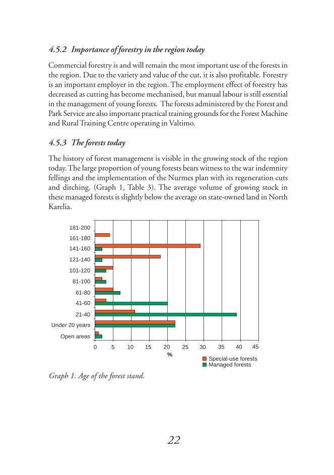
The history of forest management is visible in the growing stock of the regiontoday. The large proportion of young forests bears witness to the war indemnityfellings and the implementation of the Nurmes plan with its regeneration cutsand ditching. (Graph 1, Table 3). The average volume of growing stock inthese managed forests is slightly below the average on state-owned land in NorthKarelia.
Graph 1. Age of the forest stand.
Under 20 years
0 5 10 15 20 25 30 35 40 45
Open areas
21-40
41-60
61-80
81-100
101-120
121-140
141-160
161-180
181-200
%Special-use forestsManaged forests

23
..
The proportion of old-growth forests in the managed forests is minor. Asignificant part of the old-growth forests is now included in the ecologicalnetwork or within some other use restriction. Regeneration felling will decreaseand intermediate felling increase in the near future.
Some of the special-use forests are areas proposed for protection. Half of thepoorly productive lands in special-use forests are peat production sites. Thesewere first leased and then sold to a peat production company Vapo Oy after thisplan was completed. Due to the impact of draining the mires, some of the non-productive land has changed into poorly productive land and some of the poorlyproductive land into forest land.
Table 3. Area and growing stock by land use and main category.
Area, ha Growing Growing stock, m3 stock, m3/ha
Managed forests- forest land 18,750 1,358,000 73- poorly productive land 1,560 27,000 17- non-productive land 290Special-use forests- forest land 1,540 205,000 134- poorly productive land 490 3,700 8- non-productive land 160Total- forest land 20,290 1,563,000 77- poorly productive land 2,050 30,700 15- non-productive land 450
A large portion of the managed forests are pine (Pinus sylvestris) stands. A standis defined as mixed forest if the proportion of the dominant tree species is lessthan 80 % of the total volume. The predominance of pine is due to the largeproportion of pine bogs and to the fact that pine has been favoured in regeneration.In the Ostrobothnia-Kainuu forest vegetation zone, pine has often been held tobe more suitable than spruce (Picea abies) for regeneration, even in mesic forests.(Graph 2). Most of the birch stands have evolved naturally from downy birchesin spruce mires. (Table 4).

24
..
Graph 2. Proportions of the various vegetation categories of mineral soils in theforest land.
Most of the open bogs drained in the past are now classified as pine bogs. In all,approximately 86 % of the peatlands in the region have been drained.Improvement ditching is considered feasible in 87 % of the ditching areas.(Table 5).
In the managed forests, 3,440 ha of the area are spruce mires, and only 260 ha ofthese have not been drained. The tree stand in these is mostly growing mixedforest. The average stock volume is 73 m3/ha. Pine bogs cover 4,420 ha of themanaged forests, and 90 ha of these remain undrained. Most of the stock inthese is growing pine stands, with an average stock volume of 71 m3/ha.
Table 4. Dominant tree species in managed and special-use forests.
Managed forests, % Special-use forests, %Pine 49 31Pine-mixed 23 14Spruce 7 22Spruce-mixed 11 30Birch 4 2Birch-mixed 5 1Other 1Total 100 100
0 10 20 30 40 50 60
Herb-rich forests
Mesic forests
Moderately dry forests
Dry forests
Nutrient-poor forests
%
Special-use forestsManaged forests

25
..
Table 5. Drained and undrained mires.
Area, ha Undrained, % Drained, %Spruce mires 3,880 11 89Pine bogs 6,730 12 88Open bogs 310 93 7Total 10,920
4.6 Natural dynamics of forests
The Swedish ASIO model has been applied to classify the frequency of fires inmineral-soil forests. The data were collected from the compartment database:
A (never) herb-rich forestspaludified and wet herb-rich mineral soil forests
S (seldom) other herb-rich mineral soil forestsmesic mineral soil forests with very fine sand, silt and clay soilpaludified and wet areas in mesic forests with other soil types
I (sometimes)other mesic mineral soil forestsall moderately dry mineral soil forestsdry mineral soil forests with moraine, very fine sand and clay soils
O (often) dry mineral soil forests with gravel, sand and fine sand soilsall nutrient-poor mineral soil forests
This experimental classification showed that 97.4 % of the mineral soils in thearea are in class I, i.e. they can be expected to have burned sometimes. Land typesthat burn seldom accounted for 2.2 % of the area and areas that burn often for0.4 % of the area. The classification was used to assess the theoretical annual arealikely to burn. The result was 108 ha/a. The classification has not been utilisedfor other purposes in the plan.
The present forest stands are considerably more uniform than they would be ifregenerated naturally through fire. Unevenly burned trees of various sizes andunburned islets tend to remain in fire-affected areas. After the fire, birch growsfirst and later gives way to mixed forest.

26
..
On the other hand, the usual rhythm of forest management corresponds to theASIO model. Because the forest has regenerated in an average cycle of 110 years,there have theoretically not been large old-growth forests in mineral soil areas.
5 SUB-SECTIONS OF THE PLAN
5.1 Important sites for biodiversity
5.1.1 Valuable habitats
Nature protection areas form the core areas of nature protection, and they aresupplemented by sites outside protection areas, which are defined as valuablehabitats. Data on the valuable habitats were obtained from the landscape ecologicalfield inventory (Table 6) and from earlier inventories (Hottola 1996, Laitinenet al. 1998, Lindgren 1997, Pohjois-Karjalan ympäristökeskus 1997). Theecological network has been designed in such a way that most of the valuablehabitats are located within the network. However, it is not expedient to includethe remotely located valuable habitats scattered here and there in the network,but these will be considered in forestry planning.
Sites defined as habitats of particular significance as referred to in the Forest Actwere found to constitute 89 ha of the planning region, or just 0.4 % of the totalarea. However, the actual area of statutory sites is probably larger. The fieldworkcovered only a portion of the planning region, and the data will be completed inthe course of operational planning. The Environmental Guidelines to PracticalForest Management (Forest and Park Service 1997) and the Forest and WaterActs require that valuable habitats, even those outside the landscape ecologicalnetwork, should be protected.
In the inventory of valuable minor water bodies, nine valuable habitats werefound in the Valtimo state-owned forests (Pohjois-Karjalan ympäristökeskus1997). One of North Karelia's most valuable minor water bodies, includingLakes Särkilampi, Salmijärvi, Koivujärvi and Murtojärvi and the connecting riversand streams, is located in the planning region.

27
..
Table 6. Number and area of valuable habitats in managed forests in the region.
Compartments, Area, hano Forest Poorly Non- Total
land productive productiveland land
Spring 4 7.1 12.2 19.3Stream 40 77.5 2.6 80.1Small lakes 6 0.5 2.8 6.4 9.7Rock 3 3.2 0.3 3.5Cliff, shady slope 2 7.1 7.1Fertile mire 1 2.0 2.0Nutrient-poor mire 9 5.4 13.7 19.1Old-growth forest 4 11.7 11.7Young succession stage 4 8.0 8.0Natural monument 3 15.6 15.6Other valuable habitat 1 0.7 0.7Total 122.4 31.4 23.0 176.7
Felling, drainage and water quality in the surrounding forest have had an impacton the minor water bodies. The state of many minor water bodies, for instance,the Kuoppapuro stream and Lake Matalajärvi, was slightly altered (grades 3 and3-4), while others, such as Lakes Salmijärvi and Murtojärvi, were found to bevery nearly in their natural state (Grade 4). According to the classification of theNorth Karelia Regional Environment Centre (1997), a water area can be said tobe very nearly in a natural state when its shores are entirely and its catchment areaalmost entirely mature, uncut and undrained forest or mire. The valuable minorwater bodies are included in the ecological network. The ecological networkcontains at least the inventoried minor water body itself and the adjoining shorecompartment.
Only eight per cent of the peatlands in the managed forests in the area remainundrained, which means that all virgin mires can be considered valuable habitats.By decision of the Forest and Park Service, virgin mires are no longer drained,which means that they will remain in their current state, even though they arenot all included in the landscape ecological network. Fertile mires also deserveattention, even if drained. The data on mires in table 6 are deficient, as field datawere mostly collected from forested compartments (see 3.1). The data will be

28
..
supplemented when nutrient-poor and fertile mires are coded as valuable habitatsat the same time as the compartment database is updated.
Along the streams and on lakeshores, there are small alluvial herb-grass sprucemires and cloudberry (Rubus chamaemorus) and horsetail (Equisetum sylvaticum)spruce mires. The most fertile mires in the region, mesotrophic and eutrophicpine fens, are located in Ruostekorpi and along the Kolkonjoki river. Thevegetation of these mires includes melancholy thistle (Cirsium helenioides), lesserclubmoss (Selaginella selaginoides), juniper, cotton deergrass (Trichophorumalpinum), dioecious sedge (Carex dioica) and purple moor-grass (Molinia caerulea).The bedrock in the area contains alkaline minerals, which makes the mires fertile.The only biotope in the region protected under the Nature Conservation Act isa 2-hectare common alder type spruce mire in the Palmikki area. The area hasbeen drained, and is not currently in a natural state as required in the Act.
One objective of Landscape Ecological Planning is to restore valuable habitats tothe state they were in before silvicultural management. In the field inventory,most of the valuable habitats (58 %) were assessed as being in an almost naturalstate, and no measures are proposed for them (Table 7). One fourth of the valuablehabitats are not in a natural state, but they are expected to return to this statewithout active management.
Most often restoration means that we try to return the natural state of drainedpeatlands. As a rule, the ditches in drained peatlands now assessed as undrainableare no longer cleared; their banks are allowed to collapse and to grow over. In themanaged forest area, these mires account for 1,148 hectares, or 12 % of thedrained mires. Also, all drained mires within the ecological corridors are leftuncleared (737 ha); 28 % of these have been found to be undrainable. In theplan, these areas have been assigned no management or valuable habitat codes.Areas to be actively restored to their natural state are the mires surrounding theKuoppasuo drainage prohibition area, and the common alder-spruce mire inPalmikki, a total of 7.4 hectares. In these areas, the ditches are refilled mechanically.By decision of the Forest and Park Service, all drained mires in nature conservationareas are to be restored to their natural state, which means a restoration task ofabout 20 hectares in Valtimo's Natura proposal areas, e.g. at the old-growthforest protection sites of Ukonkuivuuvaara and Sormusenvaara.

29
..
Table 7. The need for management of valuable habitats in managed forests in theregion.
Required operations; area, ha No Natural state Requires Un- Total
management restored restoration defined required without
managementSpring 3.8 15.5 19.3Stream 56.8 15.3 8.0 80.1Small lakes 9.2 0.5 9.7Rock 3.4 3.4Cliff, shady slope 4.8 2.4 7.2Fertile mire 2.0 2.0Nutrient-poor mire 5.2 8.5 5.4 19.1Old-growth forest 11.7 11.7Young succession stage 5.8 2.2 8.0Natural monument 10.6 4.9 15.6Other valuable habitat 0.7 0.7Total 100.2 42.0 7.4 27.0 176.7
5.1.2 Occurrences of threatened species
In autumn 1997, an inventory was made of the bracket fungi in the managedforest compartments in the region. The inventory focused on the central Murto-vaara-Ukonkuivuuvaara area, mostly on compartments between the proposedold-growth forest protection sites. Selection criteria for the compartmentsincluded the amount of standing and fallen deadwood, abundance of broadleavesand the development class of the stock. In the inventory, 17 nationally and 4regionally threatened species of bracket fungi were found (Appendix 2). Inaddition, 16 old-growth forest indicator species were found in the managedforests in the region (Kotiranta & Niemelä 1996), some of which are at thesame time indicators in the GIS fieldwork guidelines (Forest and Park Service1997). In a few sites in the region, bracket fungi had been inventoried previously(Lindgren 1997). Penttilä (1996) has found 18 nationally threatened bracketfungi species in the Hiidenportti National Park and Porkkasalo areas borderingon the planning region, although in this case the period of inventory wasconsiderably shorter.

30
..
The planning region includes a few flying squirrel territories, some of them inthe proposed old-growth forest protection sites, some in the managed forestcompartments. In bird-life inventories, the merlin (Falco columbarius) and thered-breasted flycatcher, which are among the nationally threatened species, havebeen found in the area, along with several territories of the regionally threatenedSiberian jay (Hottola 1996). All in all, the bird population indicative of old-growth forests is diverse. Specific inventories have not been carried out for othergroups of organisms.
Table 8. Number of habitats of valuable species.
Habitats of valuable Managed forest species, compartments
no no haSpecies requiring special protection 5 5 45.2Nationally threatened species 99 47 263.5Regionally threatened species 64 11 36.9Other important species 4 2 4.6Total 172 65 350.2
In the most valuable compartments, several species classified as threatened co-exist. In 65 forestry compartments in the region, there were a total of 172occurrences of species requiring special protection, nationally or regionallythreatened species or other important species (Table 8). Other importantoccurrences refer, for instance, to the nesting trees of birds of prey that are notthreatened. The ecological network was designed to connect most habitats ofthreatened species by means of the ecological corridor. If there are severaloccurrences of one species within one compartment or several adjacentcompartments, these were called stepping stones. Individual occurrences ofthreatened species remaining outside the ecological network will be taken intoaccount in operational planning.
5.1.3 Enhancement of biodiversity
It was not considered practical to name actual sites for the enhancement ofbiodiversity in this plan. The region has broadleaves growing in young managedforests as the primary and secondary tree species. Purely coniferous stands arenot typical of the area. Burned wood is expected to be obtained from prescribedburning. However, the code reserved for sites where biodiversity is to be enhanced
31
..
has been used exceptionally for those drained mires outside the ecologicalnetwork which are left to return to their natural state on their own.
5.1.4 Ecological network
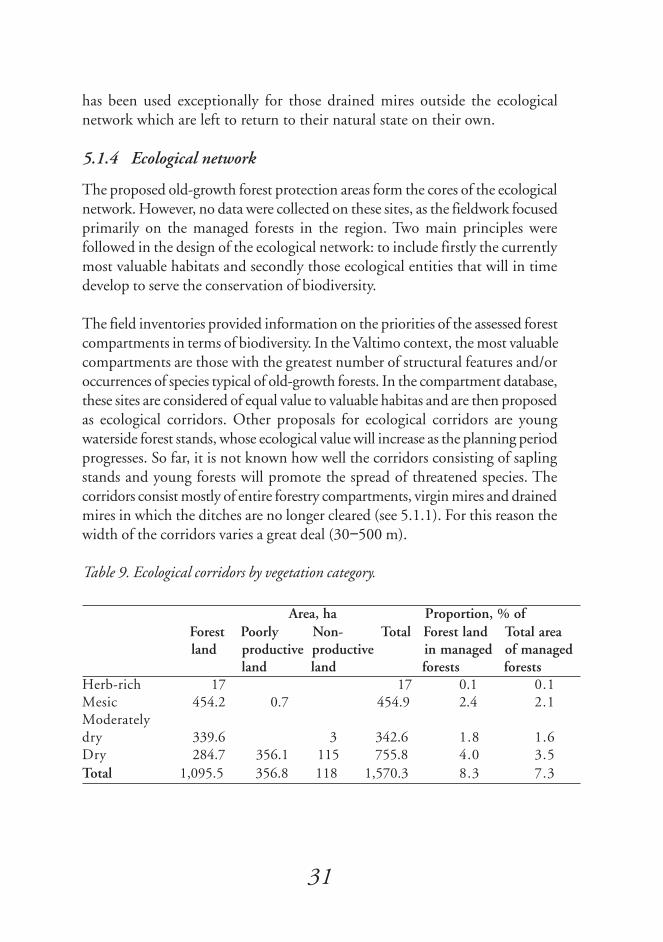
The proposed old-growth forest protection areas form the cores of the ecologicalnetwork. However, no data were collected on these sites, as the fieldwork focusedprimarily on the managed forests in the region. Two main principles werefollowed in the design of the ecological network: to include firstly the currentlymost valuable habitats and secondly those ecological entities that will in timedevelop to serve the conservation of biodiversity.
The field inventories provided information on the priorities of the assessed forestcompartments in terms of biodiversity. In the Valtimo context, the most valuablecompartments are those with the greatest number of structural features and/oroccurrences of species typical of old-growth forests. In the compartment database,these sites are considered of equal value to valuable habitas and are then proposedas ecological corridors. Other proposals for ecological corridors are youngwaterside forest stands, whose ecological value will increase as the planning periodprogresses. So far, it is not known how well the corridors consisting of saplingstands and young forests will promote the spread of threatened species. Thecorridors consist mostly of entire forestry compartments, virgin mires and drainedmires in which the ditches are no longer cleared (see 5.1.1). For this reason thewidth of the corridors varies a great deal (30−500 m).
Table 9. Ecological corridors by vegetation category.
Area, ha Proportion, % of Forest Poorly Non- Total Forest land Total area land productive productive in managed of managed
land land forests forestsHerb-rich 17 17 0.1 0.1Mesic 454.2 0.7 454.9 2.4 2.1Moderatelydry 339.6 3 342.6 1.8 1.6Dry 284.7 356.1 115 755.8 4.0 3.5Total 1,095.5 356.8 118 1,570.3 8.3 7.3

32
..
A total area of 1,665 ha has been classified as ecological corridors or biodiversityenhancement areas in the region; of this, 1,104 ha (66 %) is forest land, 427poorly productive land and the rest non-productive land. 40 % of the forestland in the corridors is mature for regeneration felling. Compartments withpredominance of broadleaves were favoured in the planning of watersidecorridors. The total area of the ecological network, consisting of the proposedprotection areas, Kuoppasuo drainage prohibition area, ecological corridors andindividual valuable habitats is 3,086 hectares, which is approximately 13 % ofthe planning region (Table 10).
Table 10. Ecological network by vegetation category.
The ecological network includes protected areas in the region and valuable habitats, occurrences ofspecies requiring special protection, ecological corridors and biodiversity enhancement areas in themanaged forests.
The ecological networks in the two parts of the planning region have not beenconnected since there is intervening private land. Five proposed old-growth forestprotection areas: Nikara, Ukonkuivuuvaara, Kivimäki, Murtovaara andSormusenvaara, and the Syvälammit old-growth forest area, are connected by acontinuous ecological corridor. The Marjomäki and Piilopirtinaho forests,separated from these, are interconnected by a corridor following the Palmikkijokiriver.
In areas bordering on state-owned lands, the ecological corridors reach municipalboundaries at several points and continue as part of the landscape ecologicalnetworks of the Nurmes and Sotkamo municipalities. In this way, a connectionis created to the core areas of these neighbouring regions, e.g. the Hiidenporttiand Tiilikka National Parks and the Peurajärvi recreational fishing area.
Protected Important sites for biodiversityarea, ha in managed forests, ha
Forest Poorly Non- Total in Totalland productive productive managed
land land forestsHerb-rich 22.5 22.5 22Mesic 491.3 530.3 0.7 531.0 1,022Moderately dry 434.1 350.0 3.0 353.0 787Dry 373.5 304.9 436.1 140.2 881.2 1,255Total 1,298.9 1,207.7 436.8 143.2 1,787.7 3,086

33
..
The stepping stones included in the ecological network are predominantly old-growth forest compartments, which complement the ecological corridors orprotected cores. For instance, there are four stepping stones north of the proposedNikara protection area; the northernmost of these is the old Simanaistenlehtoarea. In the course of the inventories, valuable species were found in these sites.
The corridors in the managed forests do not preclude recreational use. On thecontrary, it is expected that the ecological corridors and valuable habitats withinthem will promote recreation in the area.
5.2 Forest management operations
5.2.1 Forest management operations in the valuable habitats
Valuable habitats have been marked in the compartment database by codes forrestricted utilisation. The operations in these areas will follow guidelines providedby the Forest and Park Service, published in various guidebooks (EnvironmentalGuidelines to Practical Forest Management, forest management guidelines andthe landscape ecological planning manual). Usually, key biotopes are completelyexcluded from operations. Valuable landscapes are managed on their own terms,using participatory planning. Forest operations in game habitats take intoaccount the special needs of the game species concerned.
The ecological corridors include a variety of sites in the Valtimo region. Poorlyproductive and non-productive land is left untouched. Young sapling stands andthinning sites are treated normally, in keeping with the Environmental Guide-lines to Practical Forest Management and as the need for management arises.Broadleaves are favoured in sapling management and thinnings. This will resultin the growth of sturdy broadleaves, which are scarce at the beginning of theplanning period. Here and there dense stands of these trees will be allowed todevelop in their natural state.
The management operations carried out in the ecological corridors where standsare mature for regeneration will depend on the dominant tree species. Spruce-dominated stands will not be cut at all, and in pine-dominated areas, an over-extended cycle will be applied (150 to 170 years). According to the principles ofLandscape Ecological Planning, regeneration cutting may not take placesimultaneously on both sides of an ecological corridor.
34
..
5.2.2 Proportion of old-growth forests
The definition for old-growth forest is a forest which is 20 years past the normalregeneration felling age, i.e. over 120 years of age. The proportion of these forestsis currently about 8 % of the managed and special-use forest area. Some of thecompartments are in normal commercial use, which means that in another 50years, the old-growth forests will consist mainly of the older parts of theprotection areas and ecological corridors. At that time, they will constitute 6 to7 % of the forest land. In the meantime, the percentage will temporarily belower.
In the regeneration felling sites in managed forests, individual hectares of forestwill be left uncut around valuable habitats. A variety of restrictions apply to old-growth forests. The preservation of the current 8 % of old-growth forests in theplanning region will be a challenging, but rather realistic target on a 50-year timespan. In Valtimo, this target can be achieved by postponing the regenerationfelling of stands regardless of dominant tree species.
The current stands of over 120 years of age are almost exclusively coniferous. Inthe old-growth areas of the managed forests, the proportion of broadleaves isless than 6 % of the total volume.
Target: The 8 % proportion of old-growth forests will be preserved in the planningperiod. In 10 years' time, however the proportion wil be just 6 %.
5.2.3 Proportions of various tree species
The proportion of stands dominated by broadleaves in the forest land of themanaged forests is now 9 % of the area. This includes all-birch stands and mixedstands where the proportion of birches or other broadleaves is over one half. Theproportion accounted for by broadleaves in the stock volume is higher, currently13 %, counting all ages.
When the existing forest management guidelines are followed, the proportionof forests dominated by broadleaves will gradually increase in the managed forests.The aim is to increase the area dominated by broadleaves to about 10 % offorest land in 50 years. This figure presupposes an increase of birch at a rate of5 hectares a year.

35
..
Broadleaves are also present in young forests and coniferous sapling stands inthe region. The predominant species are birch, aspen and grey alder. These willhave to be favoured in future operations in order to preserve and enhancebiodiversity. In current research, new beneficial functions of broadleaves arebeing discovered in terms of forestry and the forest ecology: they have a positiveimpact on threatened species, forest litter, climatic change and the carbon cyclein the mycorrhiza. The target for the 50-year period is to increase the stock ofbroadleaves to 15 % of the total volume of managed forests in the region;according to calculations, this would appear to be more difficult than increasingtheir proportion in terms of area.
Target: In managed forests, to reach a 10 % proportion of broadleaves of the areaand a 15 % proportion of the total stock volume in 50 years.
5.2.4 Proportion of deadwood
In the inventoried compartments, the average volume of deadwood is 10 m3/ha,of which 7 m3/ha are fallen trees. In two thirds of the area inventoried, thevolume was less than 10 m3/ha. It is striking that slightly decayed wood is almostabsent from the inventoried sites (0.6 m3/ha). Semi-decayed and completelydecayed wood was more common (5.2 and 4.5 m3/ha). The data on decayingwood have been utilised in the planning of ecological corridors.
It is easy to suggest measures to ensure the existence of deadwood: the forest ismanaged in accordance with the Environmental Guidelines to Practical ForestManagement and current forest management guidelines. Tree patches or standsshould be retained on site, and small numbers of wind-fallen trees should beretained on the ground. The general aim is an average leave volume of 5 m3/ha atregeneration felling sites. Patches containing abundant deadwood should befavoured. Even though the aim is to save some of all the tree species in the area,it is especially important to leave some sturdy broadleaves standing. Visuallandscape values shall be taken into account when selecting the trees. Suitabletrees are also retained in intermediate cuts.
5.2.5 Proportion of burnt wood
No separate inventory has been made to assess the volume of burnt wood.Prescribed burning has not been carried out in the area since 1975, and therehave been no significant forest fires, so the volume of burnt wood is small.

36
..
The theoretical annual burned area in natural forest in the region, according tothe ASIO model, has been 108 hectares. This has meant a larger proportionthan at present of burnt wood and birch stands arising naturally after fires. Thelow proportion of broadleaves also in the areas proposed for protection couldbe increased by prescribed burning.
The goal is to burn one regeneration felling site with retention trees at 10 kmintervals in the region every 2 to 3 years. Since the region borders on at leastthree other planning regions, it would be wise to extend this policy to a largergeographical area. The size of the burned-over area is decided individually ineach case. In practice, the economically feasible minimum is probably 5 to 10hectares.
5.2.6 Maintenance of drained areas
Most of the first-time ditching was carried out during the implementation ofthe Nurmes plan. 92 % of mires in the managed forests in the area have beendrained. No new ditching has been started since 1994.
An important natural value in the drained mires is the large proportion ofbroadleaves. In spruce mires in the managed forests, birch stands account forabout 15 % of the area and mixed stands for 19 %. In addition, broadleavessucceed as secondary species in forests dominated by conifers. Other than this,the ecological values of the drained mires are minor, as the areas are mostlyyoung managed stands.
Ditch cleaning and improvement ditching is carried out in the old ditching areasof the managed forests, if the location fulfils the requirements for managedforests. Water protection is taken into account as prescribed in the EnvironmentalGuidelines to Practical Forest Management.
The ecological corridors contain approximately 740 hectares of drained mires,which are left to return to their natural state. In addition, 95 hectares of mireshave been selected from outside the corridors to be excluded from ditch cleaningand improvement ditching. The restoration of the most valuable habitats can beaccelerated by felling and by refilling ditches.

37
..
5.2.7 Road network
The significance of forest roads has increased, as the forest industry today needsfresh wood throughout the year. The heavier transport vehicles also place higherdemands on forest roads. The forest road network built for wood procurementalso makes hunting, fishing, picking of mushrooms and berries and other forestuses more accessible.
The region has about 200 km of forest roads accessible around the year, whichequals about 1 km per 100 hectares. There is not much need for new roads.However, roads are still needed in areas where wood was in the past forwardedto the roadside in winter only, and where the first thinnings are about to takeplace. Before planning a new forest road, the usability of the winter road isassessed. The winter road remains a practical choice in harvesting mires and inareas with high landscape or protection value. The road-building operations inthe future will mainly consist of repairing old roads. The public roads in the areaalso serve commercial forestry purposes.
The building of a forest road may have negative impacts on the landscape, watersystem, game and the ecological values of an area. The roads are planned andbuilt carefully in order to minimise environmental damage. The routing followsthe formation of the terrain. Major embankments and cuttings crossing valuablelandscapes are avoided. An effort is also made to avoid crossing ecological corridorsand streams.
5.3 Recreational use and natural economies
5.3.1 Recreation
The areas administered by the Forest and Park Service are accessible for recreationin accordance with the public right of access. The Forest and Park Service doesnot provide special recreational services or facilities in the area, as these areconcentrated in the adjacent Peurajärvi area in the municipality of Nurmes. TheForest and Park Service does not intend to build snow-mobile routes in the area.Possible routes constructed and maintained by municipalities or companies areagreed on an individual basis. A privately maintained recreational route alreadyexists in the region and is allowed for in all activities.

38
..
5.3.2 Game management
Game management on state-owned lands administered by the Forest and ParkService is based for the most part on forestry practices that take into considerationthe game populations in the region. The game habitats are inventoried and updatedin the geographical information system, where they are available for forestmanagement planning (Table 11).
The game habitats are managed in accordance with the Environmental Guide-lines to Practical Forest Management. Lekking sites are managed in such a waythat mating rituals can continue in them undisturbed. Clearing of undergrowthor thinning may be necessary at some leks to keep them attractive to capercaillie(Tetrao urogallus). Good waterside habitats for the hazel grouse (Bonasa bonasia)and the black grouse (Tetrao tetrix) will evolve naturally in the ecological corridors.
Table 11. Number of game habitats in the managed forests in the region.
Area, haForest land Poorly Non- Total
productive productiveland land
Capercaillie lek, in use 837.1 66.5 10.6 914.2Capercaillie lek,confirmation required 116.3 1.3 117.6Black grouse lek 10.6 8.5 19.1Game habitat 33.9 33.9Hazel grouse habitat 14.3 14.3Waterfowl lake 3.6 3.6Elk (Alces alces) wintering area 52.0 52.0Beaver (Castor canadensis) habitat 32.3 0.7 2.4 35.4Other game habitat 23.8 23.8Feeding site 23.6 1.5 25.1Other feeding site 1.3 1.3Total 1,138.2 80.6 21.5 1,240.3
The Forest and Park Service's small game hunting area of Halmejärvi, wherehunting is subject to licence, and parts of the Siera and Peurajärvi huntingareas are within the Valtimo region. Smaller areas have been leased to localhunting associations. Licences for elk hunting are granted annually.

39
..
5.3.3 Fish management
Landscape Ecological Planning targets at ensuring the high quality of watersand maintaining the conditions for survival for fish. Forestry operations areplanned and carried out in such a way as to minimise the nutrients and solidsdischarged into waters. The watersides are excluded from the forestry operations,and the channels are not cleaned.
The use and management of fishing waters is based for the most part on theexploitation of the existing fish stock. One-year old plankton whitefish (Coregonuspallasii) fry can be planted in some of the lakes (e.g. Autiojärvi and Kivijärvi).There is a small brown trout (Salmo trutta) stock in some of the streams andrivers (e.g. Saarijoki) resulting from fish stocking. Trout waters can be developedso that a naturally evolving trout stock is created.
5.3.4 Nature tourism
Landscape Ecological Planning has succeeded in harmonising multiple forestuses. This also enables local inhabitants to enjoy the surrounding areas in varietyof ways. One of the focal points in Valtimo is the Murtovaara farm museum, asite of cultural-historical interest, which is also surrounded by valuable forestsites.
The North Karelian forest strategy reflects hopes for increasing the number ofvisitors to the area. The environment in Finland and especially in North Kareliaoffers experiences that are unattainable in densely populated areas. Nature tourismis still in its infancy in Finland. There are also enterprises engaged in naturetourism operating on land administered by the Forest and Park Service. Thegreatest commercial interest has been in hunting-related products. The WildNorth, the recreational unit of the Forest and Park Service, cooperates withprivate enterprises to develop nature tourism services based on sustainableutilisation of the environment.
5.3.5 Valuable landscapes
The variety brought by different tree species is an asset to the visual landscape.The presence of broadleaves brings variety as the seasons change. The ecologicalnetwork with its variety of uneven-aged trees and different soil types contributesto the diversity of the landscape in the Valtimo region. There are several standsin the stepping stones that function as eye-catching points amongst the growingsapling stands.

40
..
A visual landscape only exists in the eye of the beholder. In this context, theroute to the Murtovaara farm museum was discussed in participatory meetingswith interest groups. Some of the compartments are included in the ecologicalnetwork, and some are road-side forest, where extensive areas of regenerationfelling are prohibited. The project group assigned the Pykäläkangas site the sta-tus of a stepping stone, and the visual landscape will be given special considerationin any operations in the area. In the meeting with the general public, a proposalwas made to carry out thinning of the undergrowth spruces in the area.
The recreational route "Peasant's Trail" with its shoreline forests is a typical valuablelandscape. Its most vulnerable part is the isthmus between Lakes Autiojärvi andSyrjäjärvi. Any operations on the isthmus will have to tread the narrow linebetween keeping the landscape open and retaining the feeling of a forest. LakeAutiojärvi, like other waters in the region, was also discussed in the meetingswith the public. Other sites with landscape values include the upland areas ofJysmänvaara and Petäjävaara, which are both included in the plan as steppingstones.
Impacts on the visual landscape are among the most significant environmentalaspects of forestry. This means that landscape considerations are to be taken intoaccount in all forestry operations. Visual landscape is a major attraction foroutdoor recreation.
5.3.6 Cultural sites
There are no actual national heritage sites in the region. The Murtovaara farmmuseum surrounded by state-owned lands is not officially part of the planningregion, but it is an integral part of the cultural heritage of the Valtimo region.The national landscape working group classified Murtovaara as a valuable nationalheritage landscape in 1992.
The Murtovaara farm is one of the best examples of the traditional rural buildingstyle in Finland. Fortunately for Valtimo there was not enough room for theentire farmyard in other outdoor museums, so that all the log buildings builtbetween the early 19th century and the 1950s remain on their original site. TheFoundation for Advancement of Karelian Culture has maintained the buildingsin good condition. The location of the museum is remote, but not as remote asit was before the forest road existed, when the farm was still in year-round use.The museum is open in the summer months. The sides of the road now leadingto the location are partly included in the ecological network, and due to the

41
..
special nature of the area, the primary concern of operations in the corridor islandscape management.
The streams in the region still display signs of log floating. Remnants of oldfloating constructions still remain in the Murtojoki, Palmikkijoki and Autio-joki rivers.
The boulder with old dates carved on it situated by the Kolkonjoki river is arelic of the past. The Forest and Park Service is proposing that it should beconserved under the Act on Archaeological Remains. There is a sturdy ancientpine on the shore of Lake Murtojärvi, which has the dates 1895 and 1946 carvedon its trunk. Another similar tree stands near the Murtovaara farm museum,with carved dates signifying important dates in the lives of the owners of thefarm and other significant local events (Kolehmainen & Laine 1976).
5.4 Summary of sites with special values
Some 16 % of the area of managed forests in the region is subject to variousrestrictions. Proportionally most restrictions concern old-growth forests. Table12 is compiled so that each site is listed only once, within the first category itbelongs to. In this way, the same site is not presented under two headings. Thesame hierarchy applies to the shading in the first map appendix.
Table 12. Sites with special values in the managed forests in the region.
Compartments, Area, ha % of no Forest Poorly Non- Total Forest Total land productive productive land in area of
land land managed managed forests forests
Habitats of valuablespecies 65 350 350 1.9 1.6Valuable habitats 73 110 31 23 164 0.9 0.8Ecological network 491 731 352 102 1,185 6.3 5.5Biodiversityenhancement areas 12 20 62 17 99 0.5 0.5Game habitats 239 1,011 49 11 1,071 5.7 5.0Valuable landscapes 172 202 6 208 1.1 1.0Sites with specialvalues, total 2,424 501 153 3,078 16.4 14.3

42
..
6 IMPLEMENTATION AND MONITORING OF THEPLAN
The environmental data gathered will be taken into account in operationalplanning. The information in the compartment database (GIS) will be updatedby adding the new data changed due to forest management operations and othernew data. Those in charge of forestry operations in the area are responsible forthe implementation, updating and monitoring of the plan. The implementationof the Landscape Ecological Plan is monitored with the aid of the compartmentdatabase. The achievement of the objectives relating to area is monitored in 5-year periods. The preservation of valuable habitats is monitored in connectionwith the annual follow-up inventories of nature management. The feedbackfrom participatory planning is also included in follow-up data.
Objectives of the plan and their monitoring:
Objective Monitoring Follow-upProportion of stands aged over GIS every 5 yrs120 years, % of forest areaProportion of stands dominated by GIS every 5 yrsbroadleaves in managed forests,% of forest areaProportion of broadleaves in GIS every 5 yrsmanaged forests, % of volumePrescribed burning, ha GIS every 5 yrsImplementation / management follow-up inventory annually basedof the ecological networks on samplingPreservation of valuable habitats follow-up inventory "Preservation of populations follow-up inventory "Preservation of game habitats follow-up inventory "Preservation of valuable landscapes, follow-up inventory "cultural sites and other siteswith special values
The first follow-up review of the Valtimo Landscape Ecological Plan will beheld in five years' time. The review will be organised by the representatives ofthe various units of the Forest and Park Service at the initiative of the Forestryunit. Interest groups will be informed of the results of the review. A publicmeeting will be held to report the results if it is considered that there are groundsfor it.

43
..
7 IMPACTS OF THE PLAN
7.1 Ecological impacts
So far, there is little research information on how Landscape Ecological Planninghas affected the conservation of forest biodiversity in Finland. The Forest andPark Service has made this system of steering forest management bycomprehensive ecological assessments of extensive coherent areas part of its naturalresources planning (Forest and Park Service 1997). We are constantly obtainingmore information on the impacts of Landscape Ecological Planning, and thenew information can be applied to practice immediately, as the LandscapeEcological Plans are being revised continuously as part of ongoing operationalplanning.
According to current information, approximately 700 threatened species (43%) live in the Finnish forests, more than half of them in herb-rich forests (Rassiet al. 1991). Nearly all threatened species in the mineral soil forests (86 %)depend on decaying wood and old-growth forests. The amount of deadwoodhas decreased, and felling has broken up extensive coherent old-growth forests.The fragments become isolated, and the distance between them grows. Theedge effect is magnified, and the quality of the habitat is affected more thancould be expected from the decrease in area.
The Landscape Ecological Plan of the Valtimo region will most likely have apositive impact on forest biodiversity in the area, especially on the protection ofthreatened species requiring decaying wood for survival. This is the first timethat valuable habitats and populations important for biodiversity have beeninventoried so comprehensively in the managed forests of the area. The datahave been fed into the compartment database, and numerous sites have beenproposed for exclusion from forestry operations. With the help of the ecologicalnetworks, these sites have been connected to each other and to the old-growthforest protection areas. Valuable habitats and ecological corridors addsignificantly to the nature protection network. The planning region is locatedbetween the Hiidenportti and Tiilikka National Parks, so that the corridorsproposed in this plan will also form part of the network between these twoprotection areas.
According to current knowledge, the ecological corridors have beneficial impacts.The corridors enable species to move from one islet to another in a fragmented

44
..
habitat and they can therefore be recommended for use in compliance with theprudence concept (Kouki 1993). Some species profit from the corridors, butnot all. Several species were found in the old-growth forest compartments inValtimo that need deadwood for survival, and it can be expected that corridorscontaining these compartments will promote the spread of these threatened speciesfrom one protection area to another. Corridors containing sapling stands andyoung forests will in future also be ecologically significant routes for the spreadof threatened species.
The monotonous structure of the managed forests in the area is mostlyattributable to felling trees because of war indemnity payments and theimplementation of the Nurmes plan. The structure of stands will gradually bechanged towards greater variety. Broadleaves will be favoured, sturdy broadleavesand aspen will be retained in cuts, so that the amount of deadwood in managedforests will increase with time. The volume of burned wood will be considerablyincreased when the long-forgotten method of prescribed burning is reintroducedin Valtimo with the aim of burning a regeneration site with its retention treesonce every few years. The proportion of old-growth forests, 8 % of the forestarea, is considered sufficient in Valtimo. Currently 65 % of the mature forests inthe region fall within the scope of special-use forests, the landscape ecologicalnetwork or within some other restriction as to use.
The plan will have a positive effect on the game stocks in the region. The gamehabitats have been entered in the geographical information system and they aretaken into consideration for in forest management operations. Protected areasand the ecological network increase the biodiversity of the region, which is ofbenefit both to game and threatened species.
Landscape Ecological Planning gives forestry planning an ecological focus. Therecognition and consideration of special ecological features provides theparticipants in the process with information that will help the Forest and ParkService to protect and increase the biological diversity of the forests throughconcrete measures. With the help of these measures, the Valtimo planning regionwill have greater biodiversity in 50 years' time than today.

45
..
7.2 Economic impacts
The economic impacts of the plan have been studied theoretically by a forestcutting budget calculation system (MELA). Three comparative calculations havebeen made for the region. The basic calculation A is based on normal forestmanagement in accordance with current forest management guidelines andthe Landscape Ecological Plan. Calculation B converts the restrictions on usenecessitated by the occurrence of rare species (Table 8), valuable habitats (Table7) and ecological corridors into Finnish markka and cubic metres. Calculation Ctakes these, plus all other restrictions, including the landscape and game habitatsinto account. The difference between these calculations is the calculated impactof the Landscape Ecological Plan. (Appendix 1).
Due to the age structure of the forest, the felling opportunities in the area willincrease considerably as time passes. According to the cutting budget, theeconomic impacts of the Landscape Ecological Plan will be proportionally greatestin the first 10-year period. The impact on the calculated cut is approximately 18per cent. The theoretical employment effect of the plan, without consequentialeffects, is 1.7 man-years.
In the second 10-year period, the difference in cutting volumes will be about 12%, and in later years 1−4 %. The planning period is 50 years. The estimates arebased on a 4 % interest rate.
7.3 Social impacts
The principle of participatory planning has been applied in drafting the LandscapeEcological Plan for the Valtimo region. Interest groups have reacted positivelyto the opportunity to participate, and both the interest groups of the Forest andPark Service and private citizens have cooperated in the drafting of the plan. Theproject group has obtained valuable information and the chance to create a planthat has the widest possible approval. Citizens and interest groups have providedinformation and views for the project and, in turn, gained information onLandscape Ecological Planning and the Forest and Park Service. Equally valuableis the fact that in the various meetings, the personnel of the Forest and ParkService has had the opportunity to get to know local residents and interestgroups' representatives, and vice versa.
46
..
Employment is a controversial topic in Valtimo. Forestry has traditionally beena good employer, but the decrease in the estimated cut will affect the region incoming years, although a variety of other factors will also affect employmentin the area. The young forests will require management, working methods aredeveloping and the job of the forest worker is subject to constant change. Interestgroups' and employers' expectations also change over time.
One of the objectives of the Landscape Ecological Plan is to improve Valtimo'scongeniality as a place to live and visit. This will benefit both local residents andpeople coming from elsewhere. As the lively discussion of the 1990s proves, thesmall region of Valtimo has already made its mark.

47
..
LITERATURE
Ahtiainen, M. & Huttunen, P. 1995. Metsätaloustoimenpiteiden pitkäaikaisvaikutukset puro-vesien laatuun ja kuormaan. Teoksessa Saukkonen, S. & Kenttämies, K. 1995 (toim.).Metsätalouden vesistövaikutukset ja niiden torjunta. METVE-projektin loppuraportti.s. 33−50. Suomen Ympäristö 2 - ympäristönsuojelu. Suomen Ympäristökeskus. Helsinki.
Angelstam, P. & Rosenberg, P. 1993. Aldrig, sällan, ibland, ofta. Skog & Forskning 1/93:34−41.
Hallman E., Hokkanen, M., Juntunen, H., Korhonen K-M, Raivio, S.,Savela O, Siitonen, P.,Tolonen, A. & Vainio, M. 1996. Alue-ekologinen suunnittelu. Metsähallituksen metsäta-louden julkaisuja 3. 59 s.
Heikkilä, R. 1994. Suomen suojelemattomat luonnoltaan arvokkaat suot. Käsikirjoitus. Kainuunympäristökeskus. 420 s.
Hoffren Jukka 1994. Ympäristötaloustieteen perusteet. Gaudeamus/Tammer-paino 125 s.
Hokajärvi T. (toim.) 1997. Metsänhoito-ohjeet. Metsähallituksen metsätalouden julkaisuja 10.60 s.
Hottola, P. 1996. Pohjois-Karjalan linnustollisesti arvokkaat vanhat metsät. Moniste 6 s. ja liite-kartat.
Hänninen, E., Oulasmaa, K. ja Salpakivi-Salomaa, P. 1997. Metsämaiseman hoito. Metsätaloudenkehittämiskeskus Tapio. 25 s.
Kniivilä, M. 1998. Euroopan metsämaakunta 2010. Pohjois-Karjalan metsästrategia vuosiksi 1998-2010. Pohjois-Karjalan liitto. Julkaisu 37. 95 s. + liitteet.
Kolehmainen, A. & Laine, V. A. 1976. Murtovaara, talomuseo Valtimolla. Karjalaisen KulttuurinEdistämissäätiö. 131 s. Lappeenranta.
Kotiranta, H. & Niemelä, T. 1996. Uhanalaiset käävät Suomessa. Toinen, uudistettu painos. Suo-men Ympäristökeskus. Ympäristöopas 10. 184 s.
Kouki, J., 1993. Luonnon monimuotoisuus valtion metsissä - katsaus ekologisiin tutkimustarpeisiinja suojelun mahdollisuuksiin. Metsähallituksen luonnonsuojelujulkaisuja. Sarja A 11. 88 s.
Laitinen, T., Junninen, K. Tikkanen, O.-P. (toim.) 1998: Natura 2000 Pohjois-Karjalan itä- japohjoisosissa. Pohjois-Karjalan luonnonsuojelupiirin esitys. Osa 2: Kohdekuvaukset. 78 s.ja 4 liitettä.
Lindgren, M. 1997. Uhanalais- ym. lajihavaintoja Kainuun - Pohjois-Karjalan vedenjakajaseudultasekä Kaakkois-Suomussalmelta 1997. Moniste 6 s. + liitekartat.
Maisema-aluetyöryhmän mietintö II 1992. Arvokkaat maisema-alueet. Ympäristöministeriö, työ-ryhmän mietintö 66/1992. 204 s.
Metsähallitus 1977. Nurmes-suunnitelma. Nurmeksen ja Rautavaaran hoitoalueiden metsätalou-den tehostamissuunnitelma. 58 s.
In Finnish

48
..
Metsähallitus 1997. Alue-ekologisen suunnittelun ohje 8.12.1997. Moniste.
Metsähallitus 1997. Metsätalouden ympäristöopas. 130 s. Helsinki.
Metsähallitus 1997.PATI-maastotyöohje 21.5.1997. Moniste.
Niemelä, T. 1999. Suomen kääpien määritysopas. Kahdestoista uusittu painos. Helsingin yliopis-ton kasvitieteen monisteita 169. 138 s. Helsinki.
Penttilä, R. 1996. Kainuun vanhojen metsien kääpälajisto. Metsähallituksen luonnonsuojelu-julkaisuja. Sarja A, No 35.
Pohjois-Karjalan ympäristökeskus 1997. Pohjois-Karjalan arvokkaat pienvedet. Luonnos. 81 s.,liitekartat.
Rassi, P., Kaipainen H., Mannerkoski, I. & Ståhls, G (toim.) 1991. Uhanalaisten eläinten ja kasvienseurantatoimikunnan mietintö. Komiteamietintö 1991:30. Ympäristöministeriö. 328 s.
Rissanen, K., Hirvonen, R., Mahosenaho, J. & Ollila, H. 1997. Pyhännän alue-ekologinen suunni-telma. 59 s.
Saukkonen, S. & Kenttämies, K. 1995 (toim.). Metsätalouden vesistövaikutukset ja niiden torjun-ta. METVE-projektin loppuraportti. Suomen Ympäristö 2 - ympäristönsuojelu, 419 s.Suomen Ympäristökeskus. Helsinki.
Sevola Yrjö 1983. Metsähallinnon Nurmeksen hoitoalueen voimaperäinen puunkasvatus: seuran-tajärjestelmä ja tuloksia. Folia Forestalia 574. Metsäntutkimuslaitos, Helsinki 83 s.
Siitonen, P. 1997a. Alue-ekologisen metsäsuunnittelun maastokohteiden valintaehdot. 22.4.1997Moniste.
Siitonen, P. 1997b Monimuotoisuuden arviointi MoniWin-ohjelmalla. 5.12.1997 Moniste.
Vanhojen metsien suojelutyöryhmän osamietintö 1992. Vanhojen metsien suojelu valtion maillaEtelä-Suomessa. Ympäristöministeriö, työryhmän mietintö 70/1992. 59 s. + 169 kartta-sivua.
Wilkman, W. W. 1921. Suomen geologinen yleiskartta. Lehti D4. Nurmes. Vuorilajikartan selitys.
Virkkala, K. 1948. Suomen geologinen yleiskartta. Lehti D4. Nurmes. Maalajikartan selitys. 101 s.
Virkkala, R. 1996. Metsien suojelualueverkon rakenne ja kehittämistarpeet - ekologinen lähesty-mistapa. Suomen ympäristökeskus. Suomen ympäristö 16. 53s.
ADDITIONAL READINGS
Metsähallitus - Forest and Park Service 1998. Environmental Guidelines to Practical ForestManagement. 124 p.
Loikkanen, T., Simojoki, T. & Wallenius, P. 1999. Participatory Approach to Natural ResourceManaegement. Forest and Park Service. 96 p.

49
..
Appendix 1.
REPORT OF ECONOMIC IMPACTS, LANDSCAPE ECOLOGICALPLAN FOR STATE-OWNED FORESTS IN VALTIMO
- Maximised yield value 4 %- Usage restrictions included- Optimisation restrictions for management categories- Sustainability restrictions on optimisation
A B CAll special values Codes 400-612 All ecological
included (rare species, valuable codes excludedBasic calculation habitats, ecological
corridors) excluded
Forest area, ha 20,282 20,282 20,282forest stock, m3 1,553,345 1,553,345 1,553,645forest growth, m3/a 90,272 90,141 90,141
Area per management category, ha1.0 Managed forest 16,759 17,738 19,1952.0 Retention trees 18 12 03.0 Extended cycle 1,251 1,437 04.0 Over-extended cycle 652 83 835.0 Selective cutting 68 0 06.0 No management operations 539 17 87.0 Protection areas 995 995 995Area, total 20,282 20,282 20,281
1998−2007Difference in the first period, % 100 % 117 % 118 %
Difference later in the calculation period
2008−2017planned cut 100 112 112
2018−2027planned cut 100 100 102
2028−2037planned cut 100 100 103
2038−2047planned cut 100 103 104

50
..
Appendix 2.
BRACKET FUNGI SPECIES IN MANAGED FORESTS INTHE VALTIMO REGIONThe level of endangerment classified according to Rassi et al. (1991) andNiemelä (1999).
Nationally threatened speciesAmyloporia crassa V (vulnerable)Antrodiella citrinella VGloiodon strigosus VAnomoporia bombycina Md (monitored, declining)Antrodia albobrunnea MdAntrodia pulvinascens MdGelatoporia pannocincta MdSkeletocutis lenis MdSkeletocutis stellae MdAntrodia infirma Mr (monitored, rare)Haploporus odorus MrPerenniporia subacida MrPostia hibernica MrPostia lateritia MrProtomerulius caryae MrSistotrema raduloides MrSkeletocutis odora Mr
Regionally threatened speciesClavicorona pyxidata VPhlebia centrifuga MrAmylocystis lapponica MrPhellinus viticola Mr
Old-growth forest indicatorsAsterodon ferruginosusFomitopsis roseaGloeoporus taxicolaJunghuhnia luteoalbaLeptoporus mollisOligoporus sericeomollisOnnia leporinaPhellinus chrysolomaPhellinus ferrugineofuscusPhellinus lundelliiPhellinus nigrolimitatus
Phellinus piniPhellinus populicolaPhlebia corneaPostia leucomallellaPostia placenta


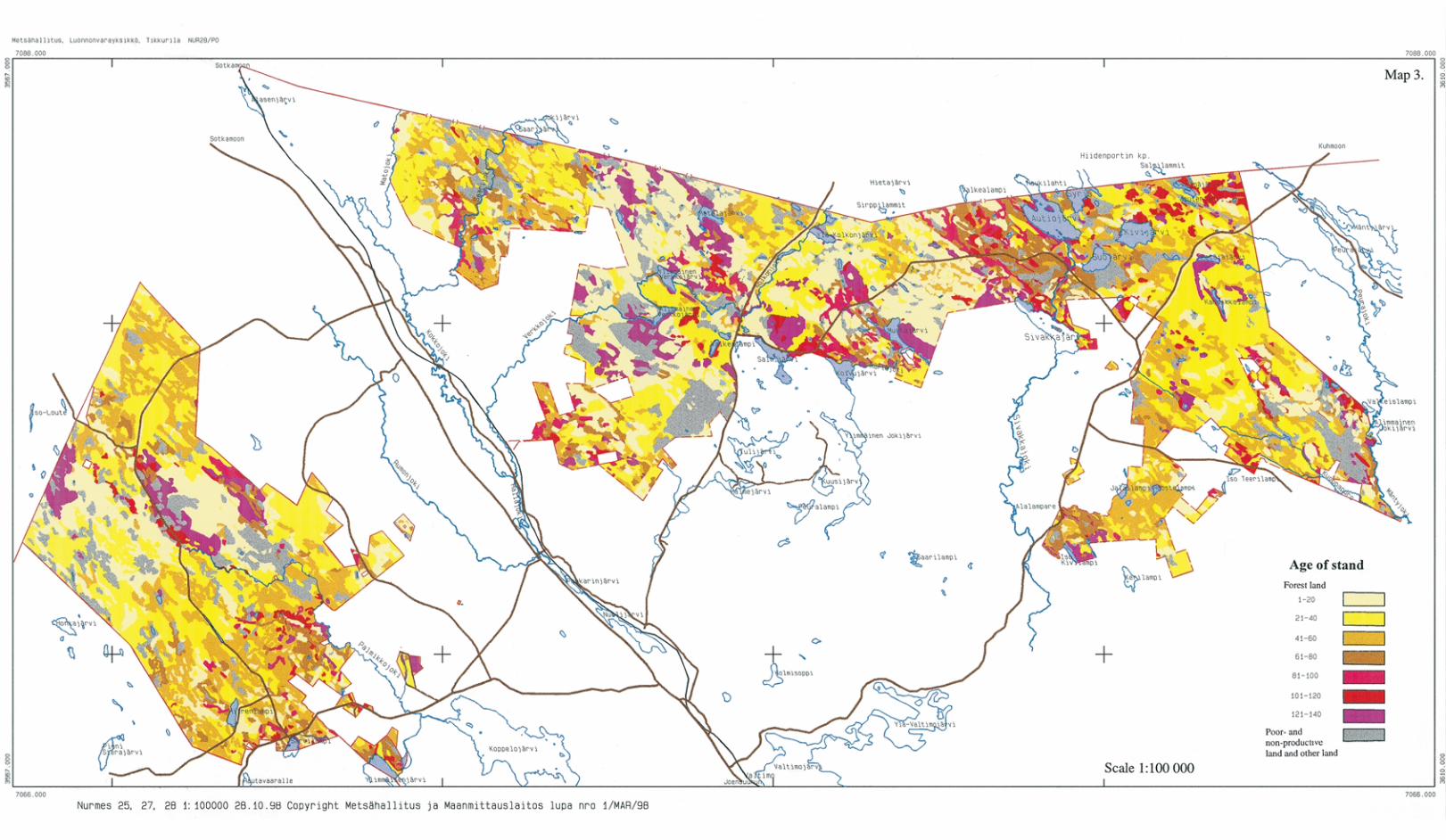

Orders of publications:
Metsähallitus - Forest and Park ServiceForestryP.O.Box 9401301 Vantaa
Tel. + 358 205 64 100Fax + 358 205 64 4500www.metsa.fi/mta/

Forestry Publications of Metsähallitus - Forest and Park Service 29 • 2000
Landscape Ecological Plan forState-owned Forests in Valtimo
Eija PitkänenKaija EistoAlpo ToivanenArto KammonenSeppo Mustonen
ISSN 1239-1670ISBN 952-446-185-4 (Printed)ISBN 952-446-186-2 (Internet)