landmark software
DESCRIPTION
All softwareTRANSCRIPT
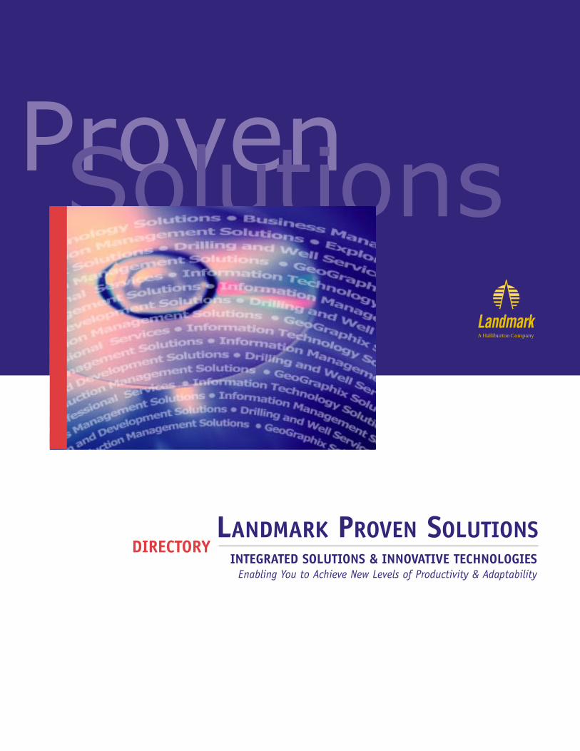
LANDMARK PROVEN SOLUTIONSINTEGRATED SOLUTIONS & INNOVATIVE TECHNOLOGIES
Enabling You to Achieve New Levels of Productivity & Adaptability
ProvenSolutions
DIRECTORY
Almost 20 years ago, Landmark Graphics first established a new standard in the
industry when it helped launch an era of computer-aided exploration that focused on
3D seismic interpretation. Since then, Landmark has continued to lead the industry
through the development of new innovative technologies and integrated solutions
that enable customers to achieve greater levels of productivity and efficiency.
In the 1990s, Landmark products and solutions expanded to include the widest
breadth of integrated exploration, drilling and production solutions across the oil
field life cycle. Landmark software, information management technology, computing
infrastructure and professional services enables petroleum companies to find, produce
and manage oil and gas reserves more effectively than at anytime in the past.
To achieve the higher levels of productivity required in today’s competitive marketplace,
Landmark offers a breakthrough in upstream oil and gas that focuses on technical-to-
business (T2B™) process integration. T2B goes far beyond basic data integration to
help you achieve higher returns through process integration, delivering an integrated
risk-based asset evaluation and enterprise portfolio management technology.
A new online service and support area called MyLandmarkSM delivers additional
customer value. Because MyLandmark is customer-driven, it dramatically enhances
the way you interact with Landmark by delivering real-time information and
knowledge resources based on your perspective, needs and self-generated profile.
“Landmark will continue to focus on leading the industry in creativity and innovation,
thus providing direction in the rapidly changing world of business and technology,” said
John Gibson, Landmark’s president and CEO.
TABLE OF CONTENTS
E&P Decision-Making Environment 2
Technical-to-Business Integration 3
Information Technology Solutions 4
Decisionarium 4
Business Management Solutions 5
TERAS 5
ARIES/RMS 5
Information Management Solutions 6-7
OpenWorks 6
OpenWorks Development Kit 6
OpenExplorer 7
OpenJournal 7
Exploration and Development Solutions 8-13
Interpret2000 8
DepthTeam 9
EarthCube 10
OpenVision 11
PostStack 11
PostStack ESP 11
PAL 11
ProMAX 12
RAVE 12
SeisWorks 12
StratWorks 13
SynTool 13
ZAP! 13
Drilling and Well Services Solutions 14-19
Drilling2000 14
CasingSeat 15
COMPASS 15
Data Analyzer 15
DIMS 15
Drillability Suite Manager 16
DrillModel 16
iDims 16
PROFILE 16
RESolution 3D 16
StressCheck 17
Wellbore Planner 17
WELLCAT 17
WELLPLAN 18
Production Management Solutions 20-23
Production2000 20
DESKTOP- VIP 20
Parallel-VIP 21
PetroWorks 21
Stratamodel 21
Z-MAP Plus 22
DSS 22
TOW/cs 23
ARIES/RMS 23
GeoGraphix Solutions 24-25
Landmark/GeoGraphix Scalable Solution 24
Discovery 24
GES 24
PRIZM 25
SeisVision 25
SeisXchange 25
WellXchange 25
Professional Services 26-27
Product Training 26
Product Support 26
Onsite Consulting 26
Project Consulting 27
I2 Consulting 27
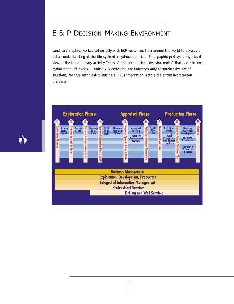
E & P DECISION-MAKING ENVIRONMENT
Landmark Graphics worked extensively with E&P customers from around the world to develop a
better understanding of the life cycle of a hydrocarbon field. This graphic portrays a high-level
view of the three primary activity “phases” and nine critical “decision nodes” that occur in most
hydrocarbon life cycles. Landmark is delivering the industry’s only comprehensive set of
solutions, for true Technical-to-Business (T2B) integration, across the entire hydrocarbon
life cycle.
2
To date, the industry has focused on integrating E&P tasks and disciplines to streamline the
technical process of finding, exploiting and managing hydrocarbon reservoirs. The next great
productivity breakthrough in upstream oil and gas will be technical-to-business process
integration, which Landmark calls “T2B.”
Few energy companies address technical and business analysis holistically, incorporating risk and
uncertainty at every link in the E&P value chain. Acquisition and analysis of technical data con-
tinue to drive business decisions. A more holistic approach reverses the process. Capital can be
allocated only when it is clear how additional technical information will impact the corporate
bottom line. The oil industry needs T2B integration to improve shareholder return on investment
and reduce costs.
At Landmark, our core competency is our ability to develop and implement software that
constructs rigorous, holistic models of the subsurface that enable our customers to evaluate
business choices in the relative safety of a virtual world, before committing to non-reversible and
expensive actions in the real world. “Rigorous” indicates that we recognize all inputs have some
degree of uncertainty, and “holistic” indicates that inputs come from a variety of technical and
business processes.
Today we can declare with confidence that we’ve made progress towards building an integrated
decision system for E&P companies so they can develop their own inventory of opportunities from
which they can create their futures. More progress will be delivered since the Landmark synchro-
nous releases going forward are aimed at enhancing the quality and utility of decision-making by
introducing functional domain improvements, more data, workflow and process integration, and
better resource allocation tools.
TECHNICAL-TO-BUSINESS INTEGRATION
3
INFORMATION TECHNOLOGY SOLUTIONS
Decisionarium (immersive environment for collaborative decision-making)
The Decisionarium™ Program is designed to leverage decision-making expertise and knowledge in
a shared data management and visualization environment. For the first time, an asset team can
take advantage of the latest in technological advances for working together to make much more
accurate and rapid decisions. Teams tackling such diverse problems as platform placement, well
engineering and prospect evaluation have achieved better answers in less time by working in a
collaborative, immersive visual environment. More than just an intriguing concept, this solution
has proven to have significant bottom line impact, in terms of increased production, reduced time
to first oil and significant savings in drilling costs.
While not the sole focus of collaborative work processes, underlying visualization and virtual real-
ity technologies are a key enabler. Within this broad range of technology, it is important not to
lose sight of core business needs. The whole focus is on changing behavior so that multidiscipli-
nary teams can work together in new ways to get better answers and improve business perform-
ance. Landmark’s Decisionarium program will allow your company to sift through all of the avail-
able technology and quickly design a collaborative, three-dimensional solution that best fits your
specific business needs.
In addition to helping you create your own collaborative environment, Landmark also has two lab
facilities, located in Houston and Aberdeen, for lease in one, three, 10 and 20-day increments.
These environments can accommodate up to 20 team members using immersive technologies to
most effectively enable collaboration. The labs are configured with Landmark’s integrated applica-
tions and data management software as well as virtual reality hardware and devices to meet the
specific requirements of each asset team. To ensure maximum effectiveness, a Landmark collabo-
ration expert is available to facilitate sessions.
By providing an environment in which cross-functional teams of specialists can work together,
visualization and virtual-reality technology provides the first step toward a new leap in productiv-
ity. Data and visual integration, combined with new immersive environments, has created dramat-
ic new possibilities comparable in significance to the introduction of 3D seismic technology in
the 1980s. Throughout the next decade immersive, collaborative environments will have as much
impact on team productivity as the interactive workstation has had on individual productivity
over the past decade.
4
TERAS (risk-based asset evaluation and enterprise portfolio management)
TERAS™ is an integrated capital allocation system designed to capture and exploit information
generated by multidisciplinary project teams. The TERAS program combines powerful economic
evaluation and analysis with portfolio modeling and optimization.
Advanced economic modeling techniques allow the user to better identify and evaluate the
inherent uncertainties that control oil and gas accumulation, production and development
parameters, commodity prices and other economic factors that impact project profitability. These
capabilities improve the capital allocation process and, consequently, increase shareholder value.
Engineering, economic, fiscal and geoscience data provided by the respective domain specialists
are modeled in the evaluation and analysis module. This collaborative ability highlights the
interdependencies and economic impact of each team’s data. Once the analysis of individual
projects is complete, they are rolled up on a business or corporate basis. The portfolio module
then optimizes the portfolio of projects to meet a variety of corporate strategies, goals and
constraints. This process clarifies the risk and return issues, which enables management to make
better and faster decisions.
Integration with ARIES™ allows TERAS users to develop a dynamic portfolio management
system that can account for real-time changes affecting both mature producing assets and higher
risk prospects. TERAS exhibits its true power as a dynamic capital allocation tool to modify
investment strategy as new opportunities arise, prices change, additional geotechnical and
economic information become available, or as fiscal constraints change.
ARIES (economics and reserve management)
ARIES is Landmark’s integrated solution that allows you to organize, manage and evaluate your
critical economic and production data – so that you get the most return from your assets, both
today and tomorrow. Whether you are forecasting future production using decline-curve analysis,
or evaluating the economics of a property for acquisition or divestiture, ARIES enables you to
plan with confidence. ARIES/RMS™ adds a specialized system to ARIES to calculate, book,
reconcile, track and report petroleum reserves values. It provides a standardized process to
give the user increased control and accuracy, and there are built-in government and corporate
reports to save time and effort. With RMS you can realize the benefits of integrated workflows,
information sharing and concurrent analysis, atop most standard databases. For customers using
the OpenWorks™ data management system, even more integration is provided between technical,
economics and business analyses in the Production2000 release.
BUSINESS MANAGEMENT SOLUTIONS
5
INFORMATION MANAGEMENT SOLUTIONS
6
OpenWorks (data management for integrated asset teams)
OpenWorks is the most widely used E&P integration platform and project data management system
in the oil and gas industry. Based on POSC, PPDM and other open systems standards, OpenWorks
offers the E&P professional the broadest range of oil field data in one database. As the foundation
of Landmark’s integrated application suite, OpenWorks is designed to meet the needs of an entire
asset team, ranging from the exploration geophysicist with limited access to well data, to
production geologists and drilling engineers working with the full extent of all geological
assets in a field.
OpenWorks offers not only a common data model to integrate pertinent data from various
disciplines, but a common communication method between applications and a range of project
and data management utilities, all of which facilitate increased data integrity for the asset team.
OpenWorks Development Kit (integration for external applications into OpenWorks)
The OpenWorks Development Kit is offered externally to commercial vendors, as well as
in-house oil and gas company development groups, to enable software developers to connect
non-Landmark databases and applications directly into the integrated OpenWorks project data
environment alongside Landmark applications. The functionality offered through the development
kit is the same as used by the internal Landmark application developers. By using Landmark’s
development tools, third-party applications can access the same copy of data as Landmark
applications and can register to receive and send data using Pointing Dispatcher™ – the Landmark
communication protocol. Integration via the development kit not only increases data integrity
within an interpretation environment, but ultimately ensures choice and flexibility with a
Landmark solution.
The development kit is offered free of charge and all external developers are supported through
Landmark’s OpenWorks Developer Network (ODN) program, a web-based service located at
www.lgc.com.
OpenExplorer (regional or enterprise data management system)
OpenExplorer™ is Landmark’s advanced data management system designed for today’s rapidly
expanding E&P data environment. OpenExplorer is a scalable solution for a wide range of needs
providing corporate, regional, or asset level data management capabilities. The OpenExplorer data
architecture is fully integrated with OpenWorks, Landmark’s industry-leading project management
system, enabling users to simultaneously and seamlessly manage and integrate multiple asset
team projects. With OpenExplorer, data flows quickly and easily from field capture through master
data stores to working projects, with knowledge capture to rapidly collect and preserve results.
OpenExplorer provides support for today’s explosion in data volumes, enabling large-scale
database construction, as well as virtual database connectivity, allowing multiple working
projects and data stores to function as a single data management system.
OpenExplorer features a fully-integrated GIS, graphical and text-based data viewers, ad-hoc
query and report tools, a knowledge capture and reference system, and a full suite of data
administration tools. The OpenExplorer data model covers a broad range of data types including
well information, well logs, seismic data, field and lease information, drilling and production
data, and more, all integrated into a unified data management system.
OpenJournal (workflow and project documentation tool)
OpenJournal™ provides interactive project and workflow documentation and knowledge transfer
capabilities. A linked hierarchical workflow-oriented user interface and file structure makes this
application well suited for providing complex workflow documentation for the E&P industry.
OpenJournal provides a vehicle to deliver templates for documenting projects such as workflows,
reports, notebooks, and presentations for common tasks. OpenJournal allows users to document
crucial decision-making steps with tools such as screen capture, image annotation, text input,
and links to web sites, files, programs, e-mail, and other projects. OpenJournal publishes its
projects in HTML that can be viewed and navigated using any web browser.
7

EXPLORATION AND DEVELOPMENT SOLUTIONS
8
Interpret2000: A New Dimension in Space and Time The Landmark Interpret2000 (I2000) release features brand new technology and unprecedented
flexibility allowing every geoscientist to work in the most optimized manner. In other words,
I2000 will allow for the best answer in the shortest amount of time, tailored to your specific
business needs.
Prior to this release, and for good reason, there have been numerous references to the new seis-
mic formats. It is important however to note that Interpret2000 is much more than just seismic
data format changes. You will find numerous time-saving productivity enhancements in all of the
applications in this release. You will also benefit from the added ability to visualize your data and
pick well targets, both in your own teams and with partners. Enhancements to OpenVision™ now
permit remote collaboration allowing teams in different offices to share in the interpretation and
planning phases of their work without the added expense of time and travel.
More about productivity. The vision of I2000 is to improve ease-of-use and streamline the
interpreters’ workflow. A simple example of this is the change in the button bindings for horizon
and fault interpretation. Now the mouse clicks have been streamlined and one customer estimates
that this simple change will save them a full month during the interpretation process! In addition,
there are new features such as:
• New automated tools to shorten the interpretation time. A geoscientist can now
automatically assign faults, saving hours of work per project.
• Minimized number of menu selections and easier list searches
• Better graphics and visual capabilities in StratWorks™
Interpret2000 also improves productivity by streamlining and increasing cross-application work-
flows. One example is the ability to quickly generate velocity models and facilitate rapid iteration
between time and depth. Another example uses the new waveform classification, PAL™, RAVE™
and lithologies calculated with either StratWorks or PetroWorks™. With this information, the
geoscientist can understand depositional systems much more rapidly and with more confidence.
Seismic Data Formats. When Landmark was formed in the mid-80’s, our technology allowed
for tremendous productivity increases on the part of interpreting geoscientists. We enabled them
to interpret 2D and 3D seismic on a workstation, but without all the additional hassles that
accompany the old paper process. Still, they were basically working the same way, interpreting
line-by-line, first in-line followed by cross-line. Even today, for customers using SeisWorks™ that
process hasn’t changed much. With the Interpret2000 new data format options, you finally get to

9
interpret through volumes. You can easily and rapidly slice and dice a seismic volume any way
you choose. These new, optional data formats with greater dynamic range, provide the ability to
brick and/or compress your data in order to optimize your interpretation workflow. Today this
greatly impacts our SeisWorks customer base, but think of it as a stepping stone for moving to
true volume interpretation using EarthCube™ in the future.
If you decide to use the compressed data formats, you benefit from a dynamically applied
algorithm that can compress volumes down to much smaller sizes with little loss of fidelity. While
this creates the potential for saving precious disk space, it is more likely that you will use that
additional space to create more volumes and more types of volumes. This increased variety of
volumes will allow you to look at the different attributes of seismic data to better understand
the prospect or reservoir in order to make better decisions.
There are many customers who, for various reasons, may not want to convert their seismic data
to the new formats. That’s not a problem. In fact, the current .3dv format is the most optimized
of the data formats for interpreting in a single direction. The technology underlying the new
data formats provides the flexibility to choose the format you want to use. For instance, if an
interpreter using SeisWorks prefers a more traditional line-by-line approach, then the .3dv format
is most likely the way to go. If the geoscientist is required to continuously use a variety of
arbitrarily oriented directions for interpreting, then the bricked or compressed formats are
more likely the preferred formats to use.
That’s a new dimension of technology with productivity and flexibility in mind.
DepthTeam (depth conversion and depth imaging workflows)
DepthTeam™ provides a toolkit for velocity modeling, model refinement and validation, depth
conversion and depth imaging. The DepthTeam interpretive workflows are designed to match
the technical solution with the geologic problem. The solution is also scalable to balance
time constraints, available resources, changing business situations and tolerance for risk.
Implemented within Landmark’s integrated exploration environment, DepthTeam workflows
lead to reduced cycle times, more accurate solutions, greater confidence in interpretations
and better business decisions.
DepthTeam Express (workflows for interpreters in simple geology)
DepthTeam Express™ is a velocity modeling and depth conversion solution created specifically for
interpreters. Integration with OpenWorks, SeisWorks, ProMAX™ and the other DepthTeam offerings
EXPLORATION AND DEVELOPMENT SOLUTIONS (CONTINUED)
10
creates a workflow environment where all available well or interpreted data is easily accessible. By
integrating and calibrating different data types such as seismic velocities, TD tables, horizons and
well picks into the velocity model, depth conversions of seismic, faults and horizons will now tie
your wells in depth. This reduces uncertainty and allows you to make better business decisions.
DepthTeam Interpreter (workflows for simple geology)
DepthTeam Interpreter™ provides a toolkit for building velocity models, validating the models
and converting seismic data or interpreted horizons to depth. Integration with OpenWorks and
SeisWorks creates a workflow environment where all available well or interpreted data is easily
accessible. Validation techniques and 3D visualization give increased confidence in the accuracy
of your depth solution.
DepthTeam Explorer (workflows for moderate velocity complexity)
DepthTeam Explorer™ provides for rigorous interval velocity analysis, model building, model
validation and depth conversion. Workflow options include geostatistical risk assessment an
depthfold illumination for survey design and depth image validation. Integration with
OpenWorks, SeisWorks and ProMAX makes velocity/depth modeling an integral part of your
interpretation workflow.
DepthTeam Extreme (workflows for extreme velocity complexity)
DepthTeam Extreme™ provides comprehensive migration velocity analysis, 3D modeling and 3D
prestack depth migration workflows for very complex geologic/velocity situations. A component
of ProMAX 3D™, DepthTeam Extreme is tightly integrated with SeisWorks to create an interpretive
processing environment, where multidisciplinary teams use their collective expertise to solve
complex imaging problems.
EarthCube (high-performance volume interpretation)
EarthCube provides a completely integrated, three-dimensional, real-time seismic interpretation
system. The analysis and visualization environment forms the basis for a new direction in seismic
interpretation. Key features that allow you to manipulate your data include opacity display using
volume rendering, zooming and rotation, chair displays and animation planes. Using the unique
EarthCube seismic slice plane animation, you create arbitrary seismic slice planes in any orienta-
tion – vertical, horizontal, arbitrary or at oblique angles – then drive the slice planes throughout
the seismic volume for interpretation. In addition, EarthCube provides a full suite of interpreta-
tion tools including autotracking, fault and horizon picking, and voxel tracking. EarthCube allows
you to clearly see subtle data changes and identify hidden relationships, and its flexibility allows
you to tailor your interpretation to meet your needs, increasing your productivity and accuracy.
11
OpenVision (advanced 3D visual integration)
OpenVision is the industry’s only integrated geoscience and engineering data visualization tool
that displays the widest range of data from multiple data sources in a single 3D scene. With
OpenVision, multidisciplinary information from various geoscience applications can be accessed,
displayed and analyzed together in a single, shared visual environment. OpenVision gives every
member of your asset team access to true cross-application data, and establishes a new workflow
standard for the industry.
PostStack (poststack processing)
Built on proven and reliable algorithms from ProMAX, the industry’s leading seismic processing
software, PostStack™ offers easily accessible poststack processing functions and gives you
unmatched control over your seismic data. With PostStack, you can now optimize your data to
show particular features of interest and to create multiple interpretation scenarios. PostStack
features several quick and easy scenarios for conditioning your data without reformatting or
copying. You design the poststack processing function interactively, and apply it to fit your
needs. Tight integration with SeisWorks eliminates the need for data manipulation, providing
more time for analysis.
PostStack ESP (event similarity prediction)
PostStack ESP™ is an interpretation tool that highlights discontinuities in seismic data caused by
faulting or stratigraphic variations. This information is critical to a multidisciplinary asset team
working to extract accurate information about the subsurface in the reservoir description and
production phases. PostStack ESP operates on the seismic data itself, yielding a high resolution
and impartial image of these features, free from interpretive biases. The resulting images not only
facilitate the interpretation process, they also insure a more accurate and reliable interpretation
at every stage of a project. PostStack ESP increases the value of 3D seismic data by extracting
information to support reservoir description, wellbore planning and project risk management.
PAL (seismic attribute extraction)
PAL (poststack attribute library) enables you to enhance your understanding of the reservoir by
directly accessing SeisWorks data for attribute extraction. PAL computes statistical and complex
attributes interactively and outputs these as horizons, which can be accessed by numerous
applications throughout the interpretation process. For example, PAL attributes can be displayed
in SeisWorks or OpenVision, or evaluated in RAVE. PAL provides more than 50 possible attributes,
making attribute extraction and interpretation an integral part of your daily workflow.
EXPLORATION AND DEVELOPMENT SOLUTIONS (CONTINUED)
12
ProMAX (2D/3D seismic processing)
ProMAX for 2D and 3D seismic data processing is a complete system that features state-of-the-art
processing technology built around an intuitive, easy-to-use graphical user interface. The system
includes many interactive visualization and analysis tools. These tools give you powerful geo-
physical analysis and quality control capabilities allowing you to quickly make and implement
processing decisions. ProMAX offers features enabling efficient, high-volume processing of large
3D data sets. These features include support for parallel processing, data management and
project management, as well as support for robotic data storage devices. There are several
ProMAX modules available providing additional functionality.
ProMAX MVA™ provides a suite of interactive analysis and modeling tools for constructing and
validating interval velocity models for depth imaging. ProMAX MVA is based on the concept that
prestack depth migration of common offset sections, which use the correct velocity field, will
produce images that are structurally identical.
ProMAX 3DPSDM™ resolves structural positioning and imaging of seismic events in complex
geologic situations where conventional time/domain processing fails. ProMAX 3DPSDM provides
a scalable, target-oriented approach which allows you to conduct practical 3D prestack depth
migration in a common SMP workstation environment.
ProMAX VSP™ is used to process zero offset, offset and reverse VSP geometries. ProMAX VSP
contains a suite of tools that target the generation of conventional VSP products such as the
corridor stack, VSP-CDP transform and VSP migration. ProMAX VSP also includes a cross-well
tomography package, which handles well-to-well and surface-to-well geometries.
RAVE (attribute analysis)
RAVE is a multidisciplinary reservoir characterization tool that enables geoscientists and engineers
to automatically find, visualize and study relationships among various seismic and reservoir
attributes in familiar map and cross-section views. RAVE highlights the subtle reservoir informa-
tion hidden in seismic and production data, revealing opportunities that often went undiscovered
before RAVE made this type of analysis possible. Relationships identified in RAVE are then commu-
nicated to SeisWorks and EarthCube to determine if they have hydrocarbon significance.
SeisWorks (seismic interpretation and analysis)
SeisWorks is the industry’s technology leader for 3D seismic interpretation and analysis. Because
it supports seismic interpretation in either time or depth, SeisWorks makes depth interpretation a
13
convenient reality. SeisWorks includes full multi-survey merge capabilities allowing you to easily
combine 2D with 3D projects, and to merge multiple 3D projects without data reformatting or
reloading. The seismic balance functions allow you to correct for differences in amplitude,
phase and frequency across multiple surveys and within 2D projects. Faults can be interpreted
and edited on vertical seismic sections and time slices. SeisWorks faults are stored in the
OpenWorks database, so information from interpreters working on a single project or multiple
projects is quickly updated and instantly accessible.
StratWorks (2D geologic interpretation and well log correlation)
StratWorks is designed for geoscientists and engineers who need to efficiently generate and
evaluate prospects, characterize reservoirs and support business decisions. StratWorks augments
the traditional processes of geologic interpretation with technologically up-to-date features. Built
upon the OpenWorks project data management system, StratWorks allows asset teams to rapidly
correlate well logs, build cross-sections, tie depth to seismic-time through close integration with
SeisWorks, create maps in an integrated environment, and gives the petrophysicist a quick analysis
tool for defining lateral producing interval relationships. This integrated functionality helps
your multidisciplinary asset team’s transition from paper-based projects to a more efficient and
accessible toolkit, which reduces costly error, increases productivity, and makes it easier to
generate prospects and manage reservoirs.
SynTool (synthetic seismograms generation)
SynTool™ is an essential, integrated interpretation tool that allows you to accurately tie well
correlations, formation tops and lithologies with seismic data. SynTool provides the features you
need to create accurate synthetic seismograms, and its detailed log editing and processing
capabilities help you correct log recording and hole problems. Special thickness and zone editors
allow prediction of changes in structure and reservoir properties away from the well. Using
SynTool, seismic wavelets can be calculated, displayed and used to derive synthetics.
ZAP! (3D automatic horizon tracking)
ZAP!™ improves your productivity by automating the tedious process of picking and editing
seismic horizons within a 3D volume. Using ZAP!, you can create highly accurate interpretations
in a fraction of the time – even in areas of complex geology or low data quality. ZAP!’s unique
features include statistical analysis to help you set parameters in problem data areas and
surgically precise map-based editing capabilities that remove data busts before retracking.
ZAP! also allows autotracking within triangulated, fault-bounded blocks, so you can manage
structurally complex areas.
DRILLING AND WELL SERVICES
14
Drilling2000: Managing the Drilling Desktop Landmark’s Drilling2000 offering is one of the most complete well planning and operations solu-
tions provided in the industry. From prospect evaluation through detailed planning, operations
monitoring and ultimately post-well analysis, all elements of the drilling process are covered.
Landmark has integrated the best-of-breed technical offerings supporting well planning and exe-
cution into a suite of applications that supports complex workflows. Drilling engineers can now
make use of earth model information during both the planning process and operations. The tech-
nical well designs themselves can be planned more quickly and effectively using this comprehen-
sive suite of engineering technology. Robust analytical tools allow the analysis of operations data
to determine lessons learned as a regular part of the drilling process.
Drilling2000 incorporates Landmark’s widely-used set of drilling applications, including DIMS™,
StressCheck™, COMPASS™ and a host of others. New technology, such as the real-time operations
application RESolution 3D™ and web-enabled data access via iDims™, is featured as well.
The following workflows are easier to work through, and less time consuming, by taking
advantage of the integration features in Drilling2000.
Integrated Well Planning Workflow – Prospect to Proposal
Asset teams are often called upon to develop proposals in a minimum amount of time using hard
to access data. Using Landmark technology and processes, explorationists and drilling engineers
can work together far more efficiently to achieve this. In this workflow, earth model data from
the prospect is integrated with engineering tools to generate an accurate path plan, casing
design (shoe setting depths) and cost estimate in a drastically shortened cycle time.
Integrated Well Planning Workflow – Proposal to Program
Once a well has been approved, a detailed drilling program must be developed. Considerations
such as torque/drag, fluid behavior, temperature effects and BHA performance constraints, among
others, should be accounted for during the design process. Landmark technology is used to opti-
mize the drilling plan for performance, while estimating costs and determining risk assessment.
Real-time Decision-Making – Improving the Drilling Process
Once drilling operations begin, it is imperative that information flows as quickly as possible into
an environment where decisions can be made. RESolution 3D, technology jointly developed by
Landmark, Sperry-Sun and Halliburton, is used to migrate real time MWD, LWD and PWD data into
the Landmark OpenWorks database for operations decision support.
15
More Efficient Operations through Post-Well Analysis
Data gathered during the drilling process can be of great value when planning the next well.
The use of offset well analysis tools produces likely cost and performance characteristics of a
new well. Potential trouble areas are highlighted, vendor performance reviewed and process
improvement possibilities identified.
CasingSeat (casing shoe depth selection application)
CasingSeat™ is an accurate and easy-to-use tool to determine casing setting depth and viable
casing and wellbore schemes. It provides rigorous shoe selection calculation routines to optimize
shoe locations, based on pore pressure and fracture gradients and user-defined design constraints.
It features inventory-based management of permissible hole and casing size combinations. The
tool provides layer- and lithology-based characterization of subsurface boundary conditions and
operating constraints, including those associated with wellbore stability, minimum overbalance
and differential sticking.
COMPASS (directional path planning application)
COMPASS is the leading directional path planning tool for operators, as well as directional drilling
contractors, improving the safety, efficiency and cost effectiveness of directional path planning.
COMPASS allows well position calculations based on survey values, 2D and 3D path planning, plus
anti-collision scanning using a variety of algorithms. Complex trajectory design, torque/drag
effects, and platform placement optimization are also supported.
Data Analyzer (data analysis tool)
Data Analyzer provides an easy-to-use, powerful tool for DIMS users that assists them in gaining
maximum value from their data. Ad-hoc queries can be generated with the user selecting from the
same user-defined labels and data input structure that they are familiar with. A graphics wizard
allows easy generation of pie, line or bar charts. Direct export to Microsoft® Excel or other
spreadsheet applications is offered with the click of a button. In addition, DIMS system security
and unit handling is fully supported.
DIMS (drilling data collection and analysis system)
DIMS is a fully integrated and comprehensive operations database, communications, and engineering
information data management system for drilling and well services. DIMS is the most widely-used
drilling and well services morning reporting system in the industry. As a complete wellsite-based
operations reporting and database system, it can be easily configured to adapt to essentially any
field operating environment to facilitate operations reporting and query needs. Data Analyzer is also
included with DIMS.
DRILLING AND WELL SERVICES (CONTINUED)
16
Drillability Suite Manager (project and data flow organizer)
The Drillability Suite™ Manager is a powerful project organization tool that automates data
movement between Landmark drilling applications and OpenWorks, using Landmark’s Data
Exchange (DEX™) technology. Drillability Suite Manager allows an engineer to synchronize project
data across applications and platforms, while grouping data into easy-to-follow project folders.
DrillModel (well costing application)
DrillModel™ is a costing tool for preparation of AFE’s and budget costs, which can model every
step of the drilling operations to determine the effect of changes in well design on the well cost
in a consistent and reliable manner. In addition, it can be used to assess the cost impact of down
time, technology changes, and drilling one extended reach well versus multiple vertical wells.
iDims (web-based reporting system)
iDims provides drilling and well services morning reports, summary reports and virtually all other
information contained in the DIMS database. By combining DIMS data access security with your
corporate Intranet firewall to control site access, iDims provides managed access to current
electronic well data. Users have the ability to select individual wells, events, report types and
dates, and view the list of reports as needed.
PROFILE (wellbore schematic and data viewer)
PROFILE™ retrieves data from the DIMS database in a format defined by the user. PROFILE allows
you to configure templates defining what data is required, and its presentation format. These
templates contain wellbore schematics, tables, summaries and directional plots. Once a template
has been set up, it can be saved and re-used on any well in the DIMS database.
RESolution 3D (real-time data visualization)
RESolution 3D, a service developed jointly by Landmark Graphics and Sperry-Sun, allows real-time
updating of earth models in a 3D visualization environment. Real-time data (MWD, LWD, PWD)
from Sperry’s INSITE™ data gathering system is fed into OpenWorks NT, Landmark’s project data-
base, for use on the rig or in the office. On the rig or in the drilling engineer’s office, real-time
data can be visualized in a Windows NT® environment, along with the interpreted earth model.
This information can ultimately be fed into engineering applications such as COMPASS.
Simultaneously, the data can be sent to the office where the asset team can use all of the
seismic interpretation and log analysis technology to rework the earth model as necessary.
17
StressCheck (casing design application)
StressCheck is the leading casing and liner design tool, providing triaxial design and analysis
capabilities. Burst, collapse and axial force load cases are supported. Given a defined set of
parameters engineers can check the characteristics of a user-defined casing string, or optimize
the casing design for minimum cost.
Wellbore Planner (directional path planning in the earth model)
Wellbore Planner™ allows you to visualize and optimize potential drilling targets and plan wells
interactively within EarthCube, Stratamodel™, SeisWorks and OpenVision. Platform locations can
also be optimized. Through its integration with COMPASS, Wellbore Planner can also interact with
a wide range of drilling applications and enable interdisciplinary teams to improve productivity,
bringing geoscientists and drilling engineers together in a way that takes advantage of all their
resources.
WELLCAT (advanced drilling and production simulation application)
WELLCAT™ is an integrated, modular suite of applications used by drilling and completion
engineers to thermally simulate subsurface environments.
The WELLCAT Drill module provides transient thermal and fluid flow analysis for drilling operations.
Simulations include cementing temperatures, downhole tool temperatures, circulating mud
temperatures and other applications.
The WELLCAT Prod module allows for thermal simulation of production operations. These include
fluid circulation, liquid and gas injection, fluid production, shut-in, reactive gel treatment,
cement squeeze, spotting cement plugs and gas-lift operations.
The WELLCAT Casing module analyzes casing loads, design integrity and buckling behavior under
complex mechanical, fluid pressure and thermal loading conditions. Installation and service loads can
be defined by standard load cases, or linked to analyses performed with the Drill and Prod modules.
The WELLCAT Tube module analyzes tubing loads and movements, buckling behavior and design
integrity, under complex mechanical, fluid pressure and thermal loading conditions. Installation
and service loads can be defined by standard load cases, or linked to analyses performed with the
Prod module.
DRILLING AND WELL SERVICES (CONTINUED)
18
The WELLCAT MultiString module analyzes the casing and tubing configuration in a system
approach. Thermal simulations from Drill and Prod, together with loading conditions from Casing
and Tube, are used to determine annular fluid expansion (AFE) pressures that exist within all
trapped annuli, as well as movement of the wellhead as each string is subjected to changing
loads (thermal, pressure and applied loads).
WELLPLAN (wellbore construction design tools)
WELLPLAN™ is an integrated, modular suite of applications used by drilling engineers to develop
optimal well designs.
The WELLPLAN Torque and Drag module provides a detailed analysis of the torque and drag forces
affecting a drill string during various modes of operations (drilling ahead, tripping in, tripping
out, etc.) Drill string design can be optimized to minimize torque/drag forces and reduce the
likelihood of stuck pipe and drill string failure.
The WELLPLAN Stuck Pipe module carries out drill string failure analysis, calculates force delivered
to stuck points, forces required to set and fire jars, as well as back-off force calculations.
The WELLPLAN Hydraulics module allows the drilling engineer to design the optimum bit and
drilling fluid combination for maximum performance. Three rheological models are supported,
including Herschel-Buckley. Hydraulics provides a complete analysis of the circulation system,
selects the best jet sizes for optimum ROP, and allows study of ECD’s with regard to pore pressure
and fracture problems. Surge/swab analysis can also be undertaken, as well as hole cleaning.
The WELLPLAN Bottom Hole Assembly module models drilling performance of rotary steerable direc-
tional BHA’s utilizing finite element analysis technology. Drilling tendencies of the assembly can
be predicted and bent sub assemblies are also supported.
The WELLPLAN Critical Speed Analysis module models BHA behavior and identifies critical rotary
speeds and high stress concentration in the drill string. These are identified by utilizing finite
element analysis (FEA) and forced frequency response (FFR) techniques.
The WELLPLAN Cementing module OptiCem™ uses the latest in Halliburton cementing technology
to model the range of fluids pumped during a cementing operation, including spacers, preflush
and slurries. It helps the engineer prepare for various effects that may be observed during these
operations, such as U-tubing, differential pressures, etc. It also allows the engineer to check
that the maximum circulating pressures do not exceed the formation breakdown pressure in the
open-hole section. Other features include stabilizer placement and foam cementing technology
calculations.
The WELLPLAN WellControl module models fluid response when a kick is circulated out of the well-
bore. The application can be used in casing design to ensure the casing string can withstand the
maximum expected influx, and during operations to assist with well kill procedures. Both Wait and
Weight and Driller’s Method are supported.
The WELLPLAN Surge module is a highly sophisticated program that provides an engineer with all
of the necessary tools to optimize tripping speeds and fluid densities to avoid well control prob-
lems and formation damage during tripping and cementing operations. Surge can be used for well
planning where surge pressures need to be controlled, or it can be used to diagnose well problems
that may be related to pressure surges.
19
PRODUCTION MANAGEMENT SOLUTIONS
Production2000: Optimization Through IntegrationLandmark’s Production2000 release provides a desktop environment that enables production
optimization through integration for petroleum, reservoir, drilling, production and economics
engineers. This synchronous release provides a first major step in improving critical workflows to
optimize production and forecast production performance, while driving better, faster decision-
making, increasing returns on expenditures.
Across the E&P business, Landmark’s customers strive for greater efficiency in their work processes
and these efficiencies have been realized by the integration of G&G processes. However, the
petroleum engineering segment associated with drilling and production has yet to realize these
efficiencies, and are therefore still faced with a vast array of applications with no commonality.
This has created a cost of ownership issue for many companies.
Production2000 provides a desktop environment for data integration and a decision support
platform for use by petroleum, reservoir, drilling, production and economics engineers. At the
same time, it addresses and helps solve the cost of ownership issue. Production2000 also presents
a solution, including an integration path from engineering to G&G, by integrating the PC product
data management systems with OpenWorks.
Through Production2000, Landmark has addressed the following:
• Single source contracts from one supplier providing products and system integration;
• Lower cost of ownership through a common operating environment supported by a single
operating system and database platform, simplified installation, a consistent product licensing
scheme, and a unified data management scheme;
• Higher individual productivity through an integrated desktop environment including a
comprehensive suite of products that synergistically support critical engineering workflows;
• Faster take-up and reduced cycle time through consistent product interfaces, ease-of-use,
common look and feel, high performance and reduced functional overlap.
DESKTOP-VIP (reservoir simulation)
DESKTOP-VIP™ is a proven, full-featured reservoir simulation system that allows you to construct
accurate and consistent reservoir models. The sophistication of DESKTOP-VIP allows you to model
complex development processes which cannot be modeled using simpler methods. It offers fast
performance in large data sets and, when used with Landmark’s 3DVIEW™ visualization package,
gives you the power to display detailed well and reservoir structure information and visualize your
complex reservoirs in full color. DESKTOP-VIP offers a full suite of integrated reservoir
20
21
simulation pre- and post-processing tools and simulation modules including black oil, composi-
tional and thermal simulation.
Parallel-VIP (parallel reservoir simulation)
Parallel-VIP™ is Landmark’s parallel computing version of its industry-leading DESKTOP-VIP
reservoir simulation system. It delivers a scalable solution for faster, interactive and more
accurate simulations of large and small hydrocarbon reservoirs. Parallel-VIP simulates much larger
reservoir models or existing models in hours, rather than days or weeks. It works by breaking
the simulation model into smaller pieces and distributing them among multiple processors. This
technology can also significantly reduce or eliminate the need for upscaling geologic models prior
to simulation. Pre- and post-processors have been enhanced to provide support for these large
simulation models. Models in excess of a million grid blocks can be run without upscaling through
the pre-processor, simulation and post-processor workflow.
PetroWorks (graphical well log interpretation)
PetroWorks is a powerful, integrated, log analysis tool for asset teams conducting graphical well
log editing, analysis and interpretation. This multi-well, multi-zone project environment provides
fundamental tools for the team geoscientist/reservoir engineer, including crossplotting, log
plotting, histograms, log editing, environmental corrections and user programming. For the
petrophysicist it provides advanced interpretation modules and sophisticated user-programming
capabilities. This easy-to-use product family includes the PetroWorks Pro, PetroWorks Asset and
LogEdit™ products, and has especially tight integration with StratWorks and Wellbore Manager™.
Comprehensive integration with OpenWorks allows immediate access to results by other Landmark
products such as Stratamodel, VIP™ and Z-MAP Plus™, enabling unsurpassed productivity.
Stratamodel (3D stratigraphic geocellular modeling)
Stratamodel helps your asset teams better understand 3D reservoir characteristics, accurately define
hidden reserves in a 3D earth model, and identify potential drilling targets. Stratamodel integrates
data and knowledge from geology, geophysics, petrophysics and engineering for more effective
reservoir management. This application helps you create a comprehensive reservoir model for the
evaluation of complex internal reservoir architecture, fluid flow characteristics, volumetrics, well
planning and reservoir simulations. With Stratamodel, you can visualize the 3D reservoir model using
combinations of cross-sections, stratigraphic slices and cross-sequence connectivity displays.
Stratamodel’s onscreen digitizing capabilities enable the user to bias the distribution of reservoir
data in the inter-well region based on qualitative facies interpretations or quantitative seismic dis-
tributions. Using OpenWorks, interpretations from other applications such as SeisWorks, StratWorks,
PetroWorks and Z-MAP Plus can be easily integrated into your reservoir interpretation.
PRODUCTION MANAGEMENT SOLUTIONS (CONTINUED)
22
Stratamodel/Badley’s is an add-on module that incorporates fault seal analysis (FSA) technology
from Badley Earth Sciences, Ltd. This module extracts relevant structural and lithologic informa-
tion from Stratamodel and provides output for the delineation of uninterrupted reservoirs and
flow simulation.
The StrataSim™ module provides you with the power to more accurately model the reservoir
before full physics simulation in Stratamodel. StrataSim has been enhanced further to make
use of fault zone thickness and permeability attributes from Badley’s Fault Seal Analysis module
to investigate effects of fault seals on reservoir flow.
Reservoir Framework Builder™ (RFB) is Landmark’s Windows NT application that enables the rapid
and easy building of complex faulted framework models for input to Stratamodel. RFB generates
the framework grids and scenario file for building Stratamodel geocellular reservoir models.
The StrataMap™ module offers integrated 2D surface modeling used in Stratamodel. Stratamodel
functionality has been enhanced to complement functionality available in RFB.
Z-MAP Plus (integrated surface mapping and modeling)
Z-MAP Plus is a surface mapping and modeling component fully integrated with the OpenWorks
data management environment. This integration enables creation of more accurate reservoir
models by incorporating data and interpretations from seismic, geologic, petrophysical and 3D
geocellular models. Unique features provide capabilities for high accuracy and multiple working
scenario analyses. Workflow integration with other OpenWorks-compatible products facilitates
effective map-based asset team communication. Productivity tools allow rapid generation of
geologic models based on simplified application of geologic form and multi-step workflows.
Included in the Z-MAP Plus application is Contouring Assistant™. This tool is an intelligent
surface modeling and mapping package based on an expert system and ZCL, a powerful batch
command language which allows the user to write run streams and macros for repetitive steps.
DSS (production and reservoir surveillance system)
Dynamic Surveillance System™ (DSS™) is designed specifically to help reservoir and production
engineers in optimizing existing production or replacing proven reserves. Completion and structur-
al relationships between wells can be identified using the DSS cross-section capabilities to display
wellbore, log and zone data. Users can easily search for anomalous reservoir behavior using
dynamic bubble, pie contour mapping. Engineers can monitor well performance indicators such as
production and injection rates, pressures, artificial lift conditions and mechanical failure trends
23
to identify workover and stimulation opportunities. DSS provides direct links to company databases
such as Microsoft Access, SQL Server, ORACLE® and Sybase®. In Landmark’s Production2000 release, DSS
seamlessly connects to the OpenWorks 1998.7 redesigned data model for production, annotation,
scenario and workover data.
TOW/cs (The Oilfield Workstation™/client server)
TOW/cs™ is an enterprise-wide production data management system that provides for the collection,
storage and analysis of production data. It has the tools you need to maintain critical operational
information in an accurate and timely manner. With TOW/cs, you can capture your production and
operations data in the field, thereby eliminating those time-consuming tasks of transcription, hand
calculations and manual report creation. TOW/cs also determines daily allocated volumes, valuable
data that can be used for detailed variance analysis. Once data is collected in the field, it is
allocated and electronically transmitted to the office, where it is used for management reporting,
production accounting and production engineering.
Maintaining accurate and timely production data plays a vital role in the success of exploration and
production companies. Decisions, both economic and engineering, are only made correctly if the
decision-maker has an accurate source of information. In addition, state and federal agencies have
instituted their own set of cumbersome accounting requirements and stringent reporting regulations.
TOW/cs is an integrated suite of applications for field data capture, production management and
optimization, production accounting, daily and monthly operations reporting and regulatory
reporting. TOW/cs calculates, summarizes, and stores data on a daily basis, allowing you to react
to the information while it is still valuable. TOW/cs also stores data on a monthly basis, allowing
corporate access to a “live” production history repository so you no longer need to move data
around to evaluate reserves and economics. Best of all, everything is in one place.
ARIES (economics and reserve management)
ARIES is Landmark’s integrated solution that allows you to organize, manage and evaluate your critical
economic and production data – so that you get the most return from your assets, both today and
tomorrow. Whether you are forecasting future production using decline-curve analysis, or evaluating
the economics of a property for acquisition or divestiture, ARIES enables you to plan with confidence.
ARIES/RMS adds a specialized system to ARIES to calculate, book, reconcile, track and report petroleum
reserves values. It provides a standardized process to give the user increased control and accuracy, and
there are built-in government and corporate reports to save time and effort. With RMS you can realize
the benefits of integrated workflows, information sharing and concurrent analysis, atop most standard
databases. For customers using the OpenWorks data management system, even more integration is
provided between technical, economics and business analyses in the Production2000 release.
GEOGRAPHIX SOLUTIONS
24
Landmark and GeoGraphix: A Fit-For-Business CombinationOver the years, Landmark’s suite of integrated applications has grown dramatically. But we
observed that our customers’ technology needs varied widely, depending on the complexity of
their E&P problems, the production potential of their assets, and the computer skills of their
users. We realized that no technical solution could fit every company’s need – or budget.
That’s why, in 1995, we acquired GeoGraphix, the industry’s leading developer of integrated G&G
software for desktop systems. To address the computing needs and financial constraints of quite
different markets, Landmark and GeoGraphix offer two distinct product lines. Primary differentia-
tors are price point and the amount of technology needed to get the job done.
GeoGraphix applications are aimed at solving fundamental technical problems with an emphasis
on core functionality, ease-of-use and affordability. Landmark provides a broader spectrum of
higher-value applications, which “push the technology envelope” by applying cutting edge
science to solve the most daunting reservoir and operational problems.
Today, GeoGraphix and Landmark offer the most diversified – and the most integrated – portfolio
of E&P technology in the petroleum industry. With Landmark and GeoGraphix to choose from,
you’ll be sure to find a fit-for-business solution, no matter what price point, operating system or
reservoir problem you have.
Discovery (streamlined interpretation workflows)
With GeoGraphix Discovery™, you can access, manipulate, analyze and interpret geologic,
geophysical, petrophysical and production-related reservoir data in a completely streamlined
workflow environment – one that allows you to spend more time interpreting the data and less
time managing it. Whether you work in asset teams – where collaboration is important – or alone,
Discovery provides a complete suite of integrated tools for evaluating and interpreting well,
seismic and log data on your Windows NT desktop.
GES (mapping, data management, and analysis)
The GeoGraphix Exploration System™ (GES™) is a powerful relational database management
system optimized for handling all forms of E&P data, including well, seismic, production, lease
and cartographic data. Integrated with the database are extensive mapping, surface modeling,
3D and final presentation capabilities, uniquely integrated within a single environment.
25
PRIZM (well log analysis)
Designed to meet the needs of the interpretive geoscientist, PRIZM™ provides an intuitive user
interface optimized to quickly and accurately interpret your well log data. Operating in the
Windows NT environment, PRIZM is well suited for both the casual user and the experienced
petrophysicist.
SeisVision (2D/3D seismic interpretation and mapping)
SeisVision™ is the only fully integrated PC-based seismic interpretation system available to the
oil and gas industry today. As part of the GeoGraphix Discovery integrated suite of geoscience
applications, SeisVision provides the geophysical interpretation tools needed to evaluate 2D or 3D
seismic data from onshore or offshore environments, in simple to complex geological regimes.
SeisVision’s base-level integration of seismic and geologic data gives you the information needed
to better understand your prospect.
SeisXchange (data transfer tool)
SeisXchange™ is a PC-based integration tool designed to allow SeisVision and SeisWorks users to
move seismic and interpretation data easily back and forth between the two systems. SeisXchange
is an add-on to SeisVision. Using common Windows® menu items, you may select SeisWorks data
by first choosing the UNIX® server on which the SeisWorks project data resides, then select the
project and seismic data from a series of pull-down menus. The selected seismic and/or interpre-
tation data is copied and converted to SeisVision’s data formats on the SeisVision client.
WellXchange (data transfer tool)
WellXchange™ is a PC-based integration tool designed to link the GeoGraphix Exploration System
(GES) with the OpenWorks and GXDM data models. Two versions of WellXchange are available:
WellXchange and WellXchange OWC. Prior to the R99.2 release WellXchange and WellXchange OWC
were a single product and known only as WellXchange. Today, WellXchange provides GES users with
the ability to exchange data between the GES system and the GXDM well data model used within
the GeoGraphix geological interpretation and mapping system GESXplorer.
PROFESSIONAL SERVICES
Landmark’s Professional Services mission is to help E&P companies succeed in using Landmark
technology solutions to achieve business goals. Landmark technology is the foundation of all our
services, and our service professionals are tightly integrated with our product development
groups. We can build the right mix of services to meet virtually any E&P business need. Landmark
offers a range of services for users, which can start with point product functionality and extend
all the way to creating comprehensive programs to meet strategic business requirements.
Product TrainingProduct training provides comprehensive instruction on the use of Landmark technology. Training
is conducted in state-of-the-art centers, with 12 locations around the world, plus two training
sites managed by “alliance partners”, for easy access. All instructors are certified on the Landmark
products and in the courses they teach and have close ties to Landmark’s product development
team. For many products both introductory and advanced classes are offered. Courses are designed
to provide maximum levels of hands-on experience, to answer questions and have fun.
Product SupportLandmark’s product support team provides immediate availability to help in using Landmark appli-
cations. The team is a global, seven by 24 operation that was the first in the industry to receive
certification from ZD Service & Support Consultants, after completing a rigorous audit of their
Houston-based support center. Employing a sophisticated, multi-level approach, our support
process quickly directs questions to the right source of expertise. This team is tightly integrated
to the product development team, both to answer individual questions and to spot patterns in
questions from the Landmark user community.
Onsite ConsultingOnsite consulting brings Landmark to your workplace so that your staff achieves greater value
every day from your investment in our technology. Onsite consultants are personal coaches, who
provide application troubleshooting and workflow mentoring, freeing professionals to work more
effectively and efficiently.
26

Landmark consultants network globally as a group and with the rest of Landmark, including
product development, product support and individual account teams. They are certified in key
Landmark products and coached by consulting managers. With this broad base of Landmark
support, onsite consultants can take on a variety of roles to help companies meet their
business objectives.
Project ConsultingProject consulting solves business problems using Landmark technology. The emphasis is on
improving your organization’s effectiveness whether in drilling, reservoir optimization, geophysi-
cal and geological technologies, or IT. Projects are designed to meet specific objectives, based on
either a quick review or an in-depth assessment, depending on your situation. Project consultants
are familiar with Landmark’s newest technologies and the most advanced levels of integrated
workflows, and have direct linkages to product development teams.
I2 ConsultingThe integration of people, process and technology is a complex change process for E&P businesses.
Landmark has created a team of experienced management consultants to assist companies in
scoping, planning, implementing and managing these changes across their organizations. The I2
consulting team offers the highest level of integration for your Landmark environment. The team’s
name comes from Landmark’s I2 pyramid of “informationalization and integration.” The I2 team
works with management to understand your business issues and design a program to map strate-
gic business objectives to the technology and processes needed to support those business goals.
The issues in an I2 project often start at the level of, “How can information technology drive
down my lifting costs?” Implementation programs from the I2 team often involve other parts of
Landmark’s service teams, and the group is broadly networked across the company.
27