landform lab. constructive and destructive processes constructive processes build landforms through...
TRANSCRIPT
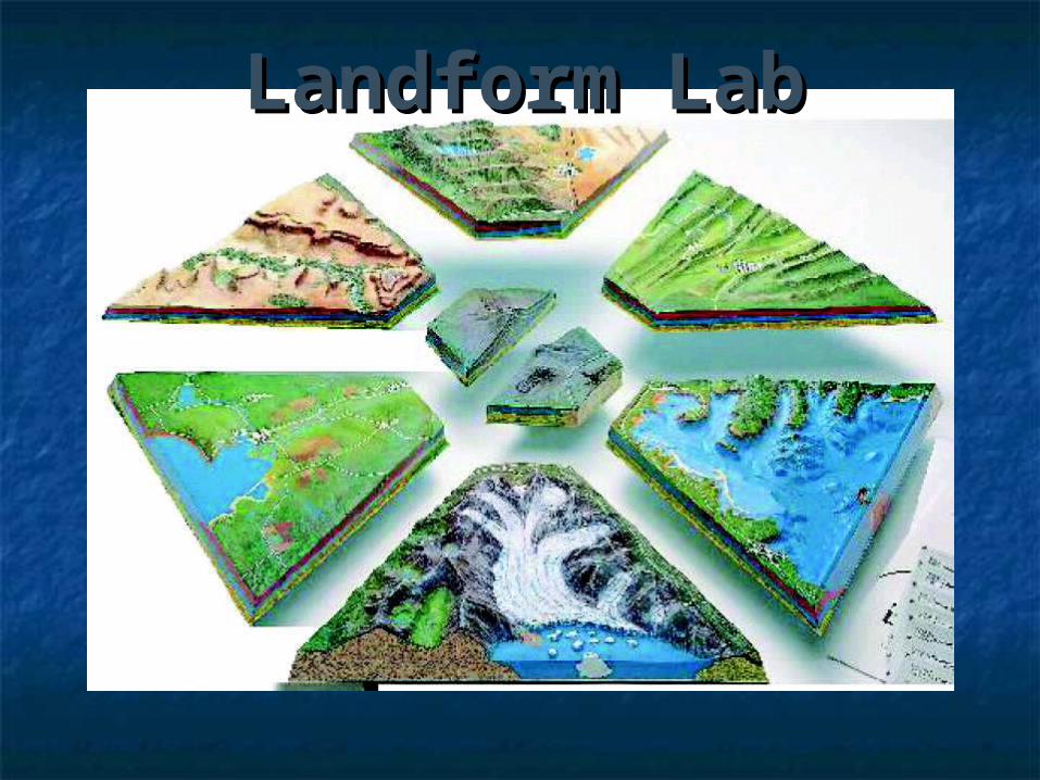
Landform LabLandform Lab

Constructive and Destructive Constructive and Destructive ProcessesProcesses
Constructive processes build landforms through tectonic and depositional processes.
Tectonic processes include movements at plate boundaries, movements at plate boundaries, earthquakes, orogeny, deformation, and volcanic activity.earthquakes, orogeny, deformation, and volcanic activity.
Deposition is the accumulation or accretion of weathered and is the accumulation or accretion of weathered and eroded materials.eroded materials.
Destructive processes break down landforms through weathering, erosion, and mass wasting.
Weathering is the disintegration of rocks by mechanical, chemical, is the disintegration of rocks by mechanical, chemical, and biological agents.and biological agents.
Erosion is the removal and transportation of weathered material by is the removal and transportation of weathered material by water, wind, ice, or gravity.water, wind, ice, or gravity.
Mass wasting is the rapid down-slope movement of materials by is the rapid down-slope movement of materials by gravity.gravity.
Other Agents and Processes that Affect Landform Development
Climate: temperature, precipitation, water cycle, atmospheric temperature, precipitation, water cycle, atmospheric conditionsconditions
Time: fast and slow rates of change : fast and slow rates of change People: influences on natural resources and earth surface
processes
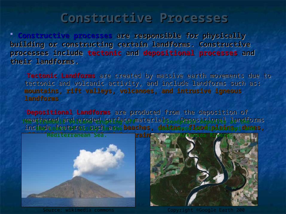
Constructive ProcessesConstructive Processes Constructive processesConstructive processes are responsible for physically building are responsible for physically building or constructing certain landforms. Constructive processes or constructing certain landforms. Constructive processes include include tectonic tectonic andand depositional processes depositional processes and their and their landforms.landforms.
Tectonic LandformsTectonic Landforms are created by massive earth movements due to are created by massive earth movements due to tectonic and volcanic activity, and include landforms such astectonic and volcanic activity, and include landforms such as: : mountains, mountains, rift valleys, volcanoes, and intrusive igneous landformsrift valleys, volcanoes, and intrusive igneous landforms
Depositional LandformsDepositional Landforms are produced from the deposition of weathered are produced from the deposition of weathered and eroded surface materials. Depositional landforms include features such and eroded surface materials. Depositional landforms include features such as: as: beaches, deltas, flood plains, dunes, alluvial fans, and glacial beaches, deltas, flood plains, dunes, alluvial fans, and glacial moraines.moraines.
Floodplain deposits at the confluence of Mississippi and
Arkansas Rivers.
The Stromboli Volcano erupting off the coast of Sicily in the
Mediterranean Sea.
Source: wikimedia commons Copyright ©Google Earth 200

Destructive ProcessesDestructive Processes DestructiveDestructive processes processes create landforms through create landforms through weathering weathering and and erosionerosion of surface materials facilitated by water, wind, of surface materials facilitated by water, wind, ice, and gravity. ice, and gravity. Mass-wasting eventsMass-wasting events occur in areas where occur in areas where weathering and erosion is accelerated.weathering and erosion is accelerated.
WeatheringWeathering is the disintegration and decomposition of rock at or near is the disintegration and decomposition of rock at or near the Earth’s surface by the Earth’s surface by mechanical, chemical, or biological mechanical, chemical, or biological weathering weathering processes.processes. Erosion Erosion is the removal and transportation of weathered or unweathered is the removal and transportation of weathered or unweathered materials by materials by water, wind, ice, and gravitywater, wind, ice, and gravity.. Mass-Wasting Mass-Wasting is a rapid period of weathering and erosion that removes is a rapid period of weathering and erosion that removes and transports materials very quickly and is often triggered by an and transports materials very quickly and is often triggered by an environmental stimuli. Mass wasting includesenvironmental stimuli. Mass wasting includes rock falls, landslides, rock falls, landslides, debris and mud flows, slumps, and creepdebris and mud flows, slumps, and creep..
Landforms formed by destructive processes include Landforms formed by destructive processes include river and river and stream valleys, waterfalls, and glacial valleys.stream valleys, waterfalls, and glacial valleys.

Tectonic LandformsTectonic Landforms Mountains: Orogenesis and DeformationMountains: Orogenesis and Deformation
FoldingFolding FaultingFaulting Fractures Fractures
Domes and BasinsDomes and Basins Horst and Graben Rift ValleysHorst and Graben Rift Valleys
Major Mountain Ranges:Major Mountain Ranges: Rocky MountainsRocky Mountains Appalachian MountainsAppalachian Mountains Himalayan MountainsHimalayan Mountains Andes MountainsAndes Mountains
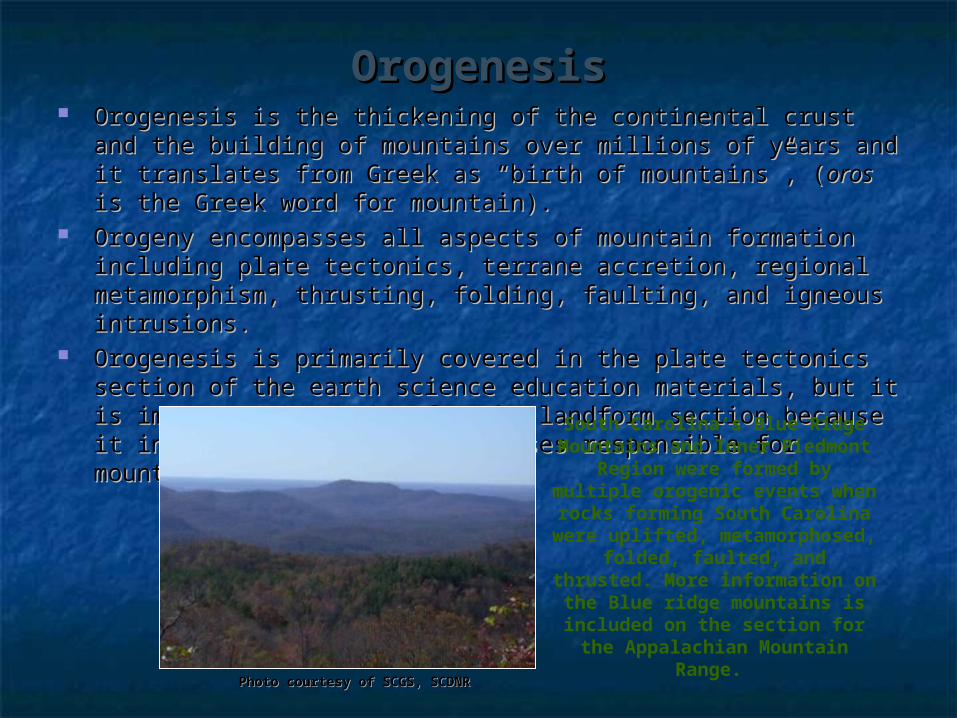
OrogenesisOrogenesis Orogenesis is the thickening of the continental crust and the Orogenesis is the thickening of the continental crust and the
building of mountains over millions of years and it translates from building of mountains over millions of years and it translates from Greek as “birth of mountains”, (Greek as “birth of mountains”, (oros oros is the Greek word for is the Greek word for mountain). mountain).
Orogeny encompasses all aspects of mountain formation including Orogeny encompasses all aspects of mountain formation including plate tectonics, terrane accretion, regional metamorphism, plate tectonics, terrane accretion, regional metamorphism, thrusting, folding, faulting, and igneous intrusions. thrusting, folding, faulting, and igneous intrusions.
Orogenesis is primarily covered in the plate tectonics section of Orogenesis is primarily covered in the plate tectonics section of the earth science education materials, but it is important to review the earth science education materials, but it is important to review for the landform section because it includes deformation for the landform section because it includes deformation processes responsible for mountain building. processes responsible for mountain building.
Photo courtesy of SCGS, SCDNRPhoto courtesy of SCGS, SCDNR
South Carolina’s Blue Ridge Mountains and Inner
Piedmont Region were formed by multiple orogenic events when rocks forming South
Carolina were uplifted, metamorphosed, folded,
faulted, and thrusted. More information on the Blue ridge mountains is included on the section for the Appalachian
Mountain Range.
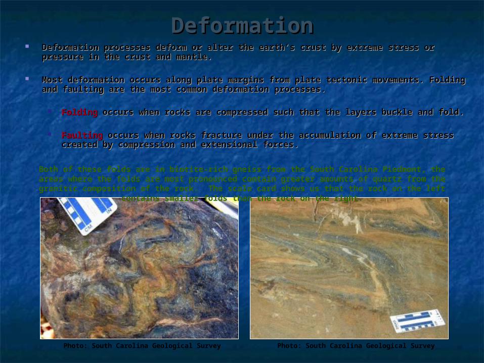
DeformationDeformation Deformation processes deform or alter the earth’s crust by extreme stress or Deformation processes deform or alter the earth’s crust by extreme stress or
pressure in the crust and mantle. pressure in the crust and mantle.
Most deformation occurs along plate margins from plate tectonic movements. Most deformation occurs along plate margins from plate tectonic movements. Folding and faulting are the most common deformation processes.Folding and faulting are the most common deformation processes.
Folding Folding occurs when rocks are compressed such that the layers buckle and occurs when rocks are compressed such that the layers buckle and fold.fold.
FaultingFaulting occurs when rocks fracture under the accumulation of extreme stress occurs when rocks fracture under the accumulation of extreme stress created by compression and extensional forces. created by compression and extensional forces.
Photo: South Carolina Geological Survey Photo: South Carolina Geological Survey
Both of these folds are in biotite-rich gneiss from the South Carolina Piedmont, the areas where the folds are most pronounced contain greater amounts of quartz from the granitic
composition of the rock. The scale card shows us that the rock on the left contains smaller folds than the rock on the right.
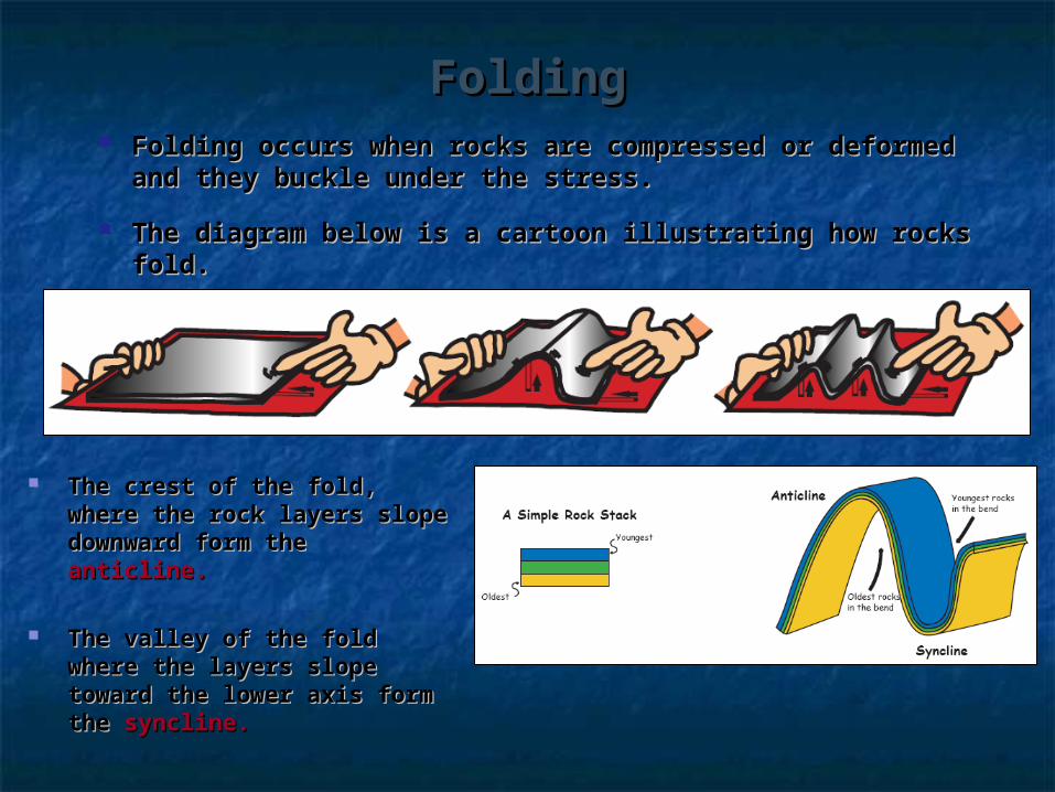
FoldingFolding Folding occurs when rocks are compressed or deformed Folding occurs when rocks are compressed or deformed
and they buckle under the stress.and they buckle under the stress.
The diagram below is a cartoon illustrating how rocks fold.The diagram below is a cartoon illustrating how rocks fold.
The crest of the fold, where The crest of the fold, where the rock layers slope the rock layers slope downward form the downward form the anticline.anticline.
The valley of the fold where The valley of the fold where the layers slope toward the the layers slope toward the lower axis form the lower axis form the syncline. syncline.

FoldingFolding Anticlines and synclines can take on slightly different geometries depending on Anticlines and synclines can take on slightly different geometries depending on
the compressional forces that form them.the compressional forces that form them.
Very intense compressional forces form tight isoclinal folds, less intense Very intense compressional forces form tight isoclinal folds, less intense compressional forces produce open folds. compressional forces produce open folds.
Folds can be asymmetric, upright, overturned, or curved. A fold pushed all the Folds can be asymmetric, upright, overturned, or curved. A fold pushed all the way over onto its side is called recumbent.way over onto its side is called recumbent.
Twisting or tilting during rock deformation and compression can cause folds to Twisting or tilting during rock deformation and compression can cause folds to form at different angles.form at different angles.
Some folds are very small and can be viewed in hand held specimens, while other Some folds are very small and can be viewed in hand held specimens, while other folds are as large as a mountain and can be viewed from aerial photos. folds are as large as a mountain and can be viewed from aerial photos.

FoldingFolding
Copyright ©USGS
Anticline exposed along NJ Route 23 near Butler NJ. The man in the
bottom of the photo helps show the scale of the folds.
SCGS photo
Overturned folds in the Table Rock gneiss in South Carolina’s piedmont. The rock hammer in the photo is used
for scale.
Copyright ©Michael Lejeune
Syncline valley between mountain peaks.
Recumbent folds in limestone.
Copyright ©Marli Miller, University of Oregon

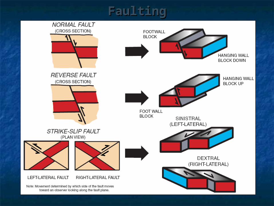
FaultingFaulting Faulting occurs when the rocks fail under deformation processes. A fault is a planar discontinuity along which Faulting occurs when the rocks fail under deformation processes. A fault is a planar discontinuity along which
displacement of the rocks occurs.displacement of the rocks occurs. There are four basic types of faulting: normal, reverse, strike-slip, and oblique.There are four basic types of faulting: normal, reverse, strike-slip, and oblique.
Geologists recognize faults by looking for off-set rock layers in outcrops.Geologists recognize faults by looking for off-set rock layers in outcrops. Faults may also be recognized by debris, breccia, clay, or rock fragments that break apart or are pulverized Faults may also be recognized by debris, breccia, clay, or rock fragments that break apart or are pulverized
during the movement of the rocks along the fault plane. Fault ‘gouge’ is a term used to describe the material during the movement of the rocks along the fault plane. Fault ‘gouge’ is a term used to describe the material produced by faulting.produced by faulting.
If a fault plane is exposed, there may be grooves, striations (scratches), and slickenslides (symmetrical If a fault plane is exposed, there may be grooves, striations (scratches), and slickenslides (symmetrical fractures) that show evidence of the rocks movement.fractures) that show evidence of the rocks movement.
Large fault systems, such as the San Andreas fault can be seen from aerial imagery.Large fault systems, such as the San Andreas fault can be seen from aerial imagery.
1. Normal: rocks above the fault plane, or hanging wall, move down relative to the rocks below the fault plane, or footwall.
2. Reverse: rocks above the hanging wall moves up relative to the footwall
3. Strike-slip: rocks on either side of a nearly vertical fault plane move horizontally
Normal
Reverse
Strike-Slip
FaultingFaulting
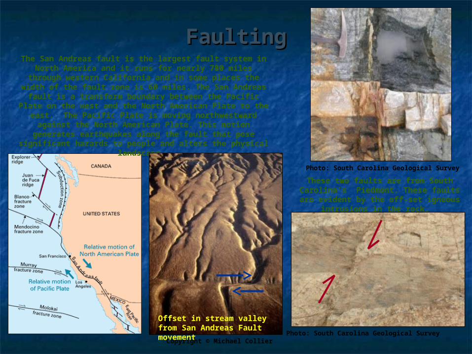
FaultingFaultingThe San Andreas fault is the largest fault system in
North America and it runs for nearly 780 miles through western California and in some places the width of the
fault zone is 60 miles. The San Andreas fault is a transform boundary between the Pacific Plate on the west and the North American Plate to the east. The
Pacific Plate is moving northwestward against the North American Plate. This motion generates earthquakes
along the fault that pose significant hazards to people and alters the physical landscape.
Offset in stream valley from San Andreas Fault movement Copyright © Michael Collier
These two faults are from South Carolina’s Piedmont. These faults are
evident by the off-set igneous intrusions in the rock.
Photo: South Carolina Geological Survey
Photo: South Carolina Geological Survey

Domes and BasinsDomes and Basins Domes and basins are large, elongated folds formed by broad warping Domes and basins are large, elongated folds formed by broad warping
processes including mantle convection, isostatic adjustment, or swelling processes including mantle convection, isostatic adjustment, or swelling from a hot spot. from a hot spot.
Upwarping produces domes, while downwarping produces basins. Upwarping produces domes, while downwarping produces basins. Geologists identify dome and basin structures by the stratified ages of the Geologists identify dome and basin structures by the stratified ages of the
rock folds:rock folds: Domes contain strata which increase in age toward the center as the contain strata which increase in age toward the center as the
younger layers are eroded from the top and sides.younger layers are eroded from the top and sides. Basins contain strata which is youngest toward the center and the contain strata which is youngest toward the center and the
oldest rocks form the flanks or sides. oldest rocks form the flanks or sides.
http://en.wikipedia.org/wiki/Michigan_Basin
This geologic map of the Michigan Basin illustrates the circular pattern of
the sedimentary strata. The green color in the center of the map
represents the youngest rocks which are Upper Pennsylvanian; and the
rocks progressively increase in age toward the periphery where the
reddish-orange colors represent the oldest rocks flanking this structure which are Ordovician and Cambrian
age.
Youngest rocks (Upper Pennsylvanian)
Oldest Rocks (Ordivician and Cambrian)
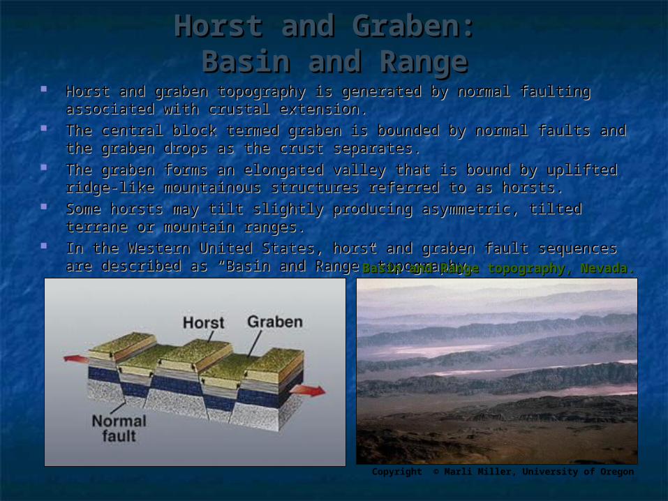
Horst and Graben: Horst and Graben: Basin and RangeBasin and Range
Horst and graben topography is generated by normal faulting associated with Horst and graben topography is generated by normal faulting associated with crustal extension. crustal extension.
The central block termed graben is bounded by normal faults and the graben The central block termed graben is bounded by normal faults and the graben drops as the crust separates. drops as the crust separates.
The graben forms an elongated valley that is bound by uplifted ridge-like The graben forms an elongated valley that is bound by uplifted ridge-like mountainous structures referred to as horsts. mountainous structures referred to as horsts.
Some horsts may tilt slightly producing asymmetric, tilted terrane or Some horsts may tilt slightly producing asymmetric, tilted terrane or mountain ranges. mountain ranges.
In the Western United States, horst and graben fault sequences are described In the Western United States, horst and graben fault sequences are described as “Basin and Range” topography. as “Basin and Range” topography. Basin and Range topography, Nevada.Basin and Range topography, Nevada.
Copyright © Marli Miller, University of Oregon

Rift ValleysRift Valleys Rift valleys are fault structures formed by normal faults.Rift valleys are fault structures formed by normal faults. Rising magma below the crust upwells, forcing the lithosphere to fracture, Rising magma below the crust upwells, forcing the lithosphere to fracture,
as it fractures and cracks, one or more faults cause the crustal rocks to as it fractures and cracks, one or more faults cause the crustal rocks to separate forming a rift valley. separate forming a rift valley.
Rift valleys can eventually form lakes or seas such as the Red Sea, which Rift valleys can eventually form lakes or seas such as the Red Sea, which separates Africa from the Arabian Peninsula. Rift valleys can become separates Africa from the Arabian Peninsula. Rift valleys can become inactive and fill in with volcanic material, such as the rift structure in the inactive and fill in with volcanic material, such as the rift structure in the United States which extends from Lake Superior to Oklahoma. United States which extends from Lake Superior to Oklahoma.
www.visibleearth.nasa.gov
East African Rift Valley LakeRift Valleys in Africa
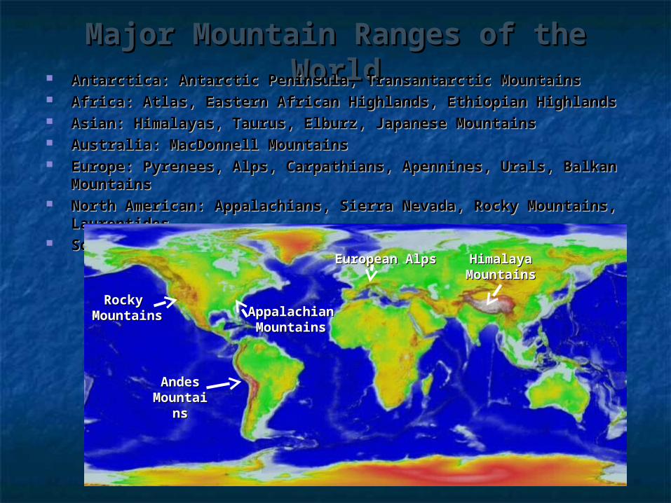
Major Mountain Ranges of the Major Mountain Ranges of the WorldWorld Antarctica: Antarctic Peninsula, Transantarctic MountainsAntarctica: Antarctic Peninsula, Transantarctic Mountains
Africa: Atlas, Eastern African Highlands, Ethiopian HighlandsAfrica: Atlas, Eastern African Highlands, Ethiopian Highlands Asian: Himalayas, Taurus, Elburz, Japanese MountainsAsian: Himalayas, Taurus, Elburz, Japanese Mountains Australia: MacDonnell MountainsAustralia: MacDonnell Mountains Europe: Pyrenees, Alps, Carpathians, Apennines, Urals, Balkan Europe: Pyrenees, Alps, Carpathians, Apennines, Urals, Balkan
MountainsMountains North American: Appalachians, Sierra Nevada, Rocky Mountains, North American: Appalachians, Sierra Nevada, Rocky Mountains,
LaurentidesLaurentides South American: Andes, Brazilian HighlandsSouth American: Andes, Brazilian Highlands
Rocky Rocky MountainsMountains
AndesAndesMountaiMountai
nsns
AppalachianAppalachianMountainsMountains
HimalayaHimalayaMountainsMountains
European AlpsEuropean Alps
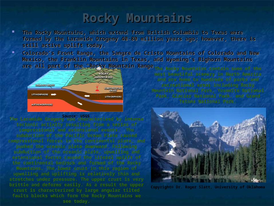
Rocky MountainsRocky Mountains The Rocky Mountains, which extend from British Columbia to Texas were The Rocky Mountains, which extend from British Columbia to Texas were
formed by the Laramide Orogeny 40-80 million years ago; however, there is formed by the Laramide Orogeny 40-80 million years ago; however, there is still active uplift today.still active uplift today.
Colorado’s Front Range, the Sangre de Cristo Mountains of Colorado and New Colorado’s Front Range, the Sangre de Cristo Mountains of Colorado and New Mexico, the Franklin Mountains in Texas, and Wyoming’s Bighorn Mountains Mexico, the Franklin Mountains in Texas, and Wyoming’s Bighorn Mountains are all part of the “Rocky Mountain Range”.are all part of the “Rocky Mountain Range”.
The Laramide Orogeny was characterized by intense tectonic activity resulting from a series of
compressional and extensional events. The subduction of the Pacific Ocean Plate caused
compressional forces in the continental plate, and pushed the oceanic plate downward. Following subduction of the oceanic plate, upwelling and
extensional forces caused the literal uplift of the continental bedrock and formed of the Rocky Mountains. The lower crust in this region of upwelling and uplifting is relatively thin and
stretches under pressure. The upper crust is very brittle and deforms easily. As a result the upper
crust is characterized by large angular tilted faults blocks which form the Rocky Mountains we see
today.
Source: USGS
The Rocky Mountains contain some of the most beautiful scenery in North America and are home to hundreds of parks and
recreational areas including Rocky Mountain National Park, Yosemite National
Park, Glacier National Park, and Grand Tetons National Park.
Copyright© Dr. Roger Slatt, University of Oklahoma

Appalachian MountainsAppalachian Mountains The Appalachian Mountains extend along the eastern margin of North America The Appalachian Mountains extend along the eastern margin of North America
from Alabama to Maine in the United States, and through the southeastern from Alabama to Maine in the United States, and through the southeastern provinces of Canada to Newfoundland. provinces of Canada to Newfoundland.
The Appalachian Mountains were formed during the Paleozoic Era from several The Appalachian Mountains were formed during the Paleozoic Era from several orogenic episodes, the Taconic Orogeny (Ordovician ~480 mya), followed by the orogenic episodes, the Taconic Orogeny (Ordovician ~480 mya), followed by the Acadian Orogeny (Devonian ~400 mya), and lastly the Alleghany Orogeny Acadian Orogeny (Devonian ~400 mya), and lastly the Alleghany Orogeny (Permian ~ 300 mya). (Permian ~ 300 mya).
Each of these major orogenic episodes involved multiple events of folding, Each of these major orogenic episodes involved multiple events of folding, faulting, metamorphism, emplacements of igneous intrusions, and uplift.faulting, metamorphism, emplacements of igneous intrusions, and uplift.
The Appalachian Mountains are divided into four major provinces: Piedmont, Blue The Appalachian Mountains are divided into four major provinces: Piedmont, Blue Ridge, Valley and Ridge, and Appalachian Plateau. Ridge, Valley and Ridge, and Appalachian Plateau.
Source: USGS
This is an aerial view of the Susquehanna River in Pennsylvania flowing through the folded and faulted Valley and Ridge Province of the Appalachian Mountains.
Waterfall carved into valley of Blue Ridge
Province of the Appalachians near the
South Carolina and North Carolina border.
Source: SCGS
www. maps.google.com
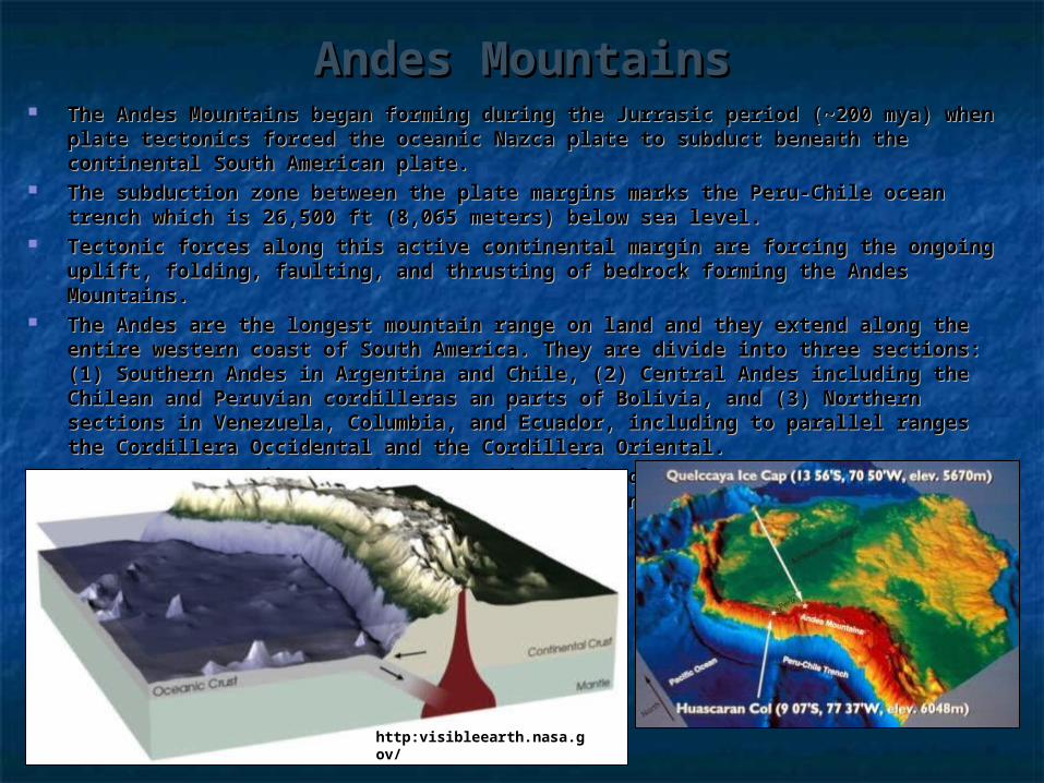
Andes MountainsAndes Mountains The Andes Mountains began forming during the Jurrasic period (~200 mya) The Andes Mountains began forming during the Jurrasic period (~200 mya)
when plate tectonics forced the oceanic Nazca plate to subduct beneath the when plate tectonics forced the oceanic Nazca plate to subduct beneath the continental South American plate.continental South American plate.
The subduction zone between the plate margins marks the Peru-Chile ocean The subduction zone between the plate margins marks the Peru-Chile ocean trench which is 26,500 ft (8,065 meters) below sea level.trench which is 26,500 ft (8,065 meters) below sea level.
Tectonic forces along this active continental margin are forcing the ongoing Tectonic forces along this active continental margin are forcing the ongoing uplift, folding, faulting, and thrusting of bedrock forming the Andes Mountains. uplift, folding, faulting, and thrusting of bedrock forming the Andes Mountains.
The Andes are the longest mountain range on land and they extend along the The Andes are the longest mountain range on land and they extend along the entire western coast of South America. They are divide into three sections: (1) entire western coast of South America. They are divide into three sections: (1) Southern Andes in Argentina and Chile, (2) Central Andes including the Chilean Southern Andes in Argentina and Chile, (2) Central Andes including the Chilean and Peruvian cordilleras an parts of Bolivia, and (3) Northern sections in and Peruvian cordilleras an parts of Bolivia, and (3) Northern sections in Venezuela, Columbia, and Ecuador, including to parallel ranges the Cordillera Venezuela, Columbia, and Ecuador, including to parallel ranges the Cordillera Occidental and the Cordillera Oriental.Occidental and the Cordillera Oriental.
The Andes Mountains contain many active volcanoes, including Cotopaxi in The Andes Mountains contain many active volcanoes, including Cotopaxi in Ecuador, one of the largest active volcanoes in the world. Ecuador, one of the largest active volcanoes in the world.
http:visibleearth.nasa.gov/
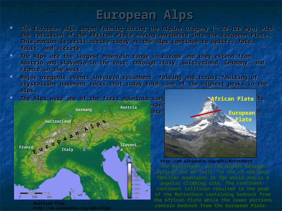
European AlpsEuropean Alps The European Alps began forming during the Alpine Orogeny (~ 20-120 mya) The European Alps began forming during the Alpine Orogeny (~ 20-120 mya)
with the collision of the African Plate moving northward into the European Plate. with the collision of the African Plate moving northward into the European Plate. This motion is still active today as the Alps continue to uplift, fold, fault, and This motion is still active today as the Alps continue to uplift, fold, fault, and accrete.accrete.
The Alps are the largest mountain range in Europe and they extend from Austria The Alps are the largest mountain range in Europe and they extend from Austria and Slovenia in the east, through Italy, Switzerland, Germany, and France in the and Slovenia in the east, through Italy, Switzerland, Germany, and France in the west.west.
Major orogenic events involved recumbent folding and thrust faulting of Major orogenic events involved recumbent folding and thrust faulting of crystalline basement rocks that today form some of the highest peaks in the crystalline basement rocks that today form some of the highest peaks in the Alps.Alps.
The Alps were one of the first mountain ranges to be studied by geologists and The Alps were one of the first mountain ranges to be studied by geologists and as a result many geomorphic terms, especially those relating to glaciation and as a result many geomorphic terms, especially those relating to glaciation and ‘alpine’ environments, were first defined in the European Alps. ‘alpine’ environments, were first defined in the European Alps.
The Matterhorn, on the border between Switzerland an Italy, is one of the most familiar mountains in the world and is a
popular climbing site. The continent-continent collision resulted in the peak of
the Matterhorn containing bedrock from the African Plate while the lower portions
contain bedrock from the European Plate.
http://en.wikipedia.org/wiki/Matterhorn
SwitzerlandSwitzerland
ItalyItalyFranceFrance
GermanyGermany AustriaAustria
SloveniSloveniaaE u r o
p e a n A l p
s
Modified from: http://en.wikipedia.org/wiki/Alps
African Plate
European Plate

Himalaya MountainsHimalaya Mountains Himalaya orogeny began 45-54 million years ago from the collision between Himalaya orogeny began 45-54 million years ago from the collision between
the India and Eurasian Plates and is still active today. the India and Eurasian Plates and is still active today. When two continental plates collide, the Earth’s crust at the plate When two continental plates collide, the Earth’s crust at the plate
boundaries is folded, faulted, overthrusted, uplifted forming an extensive boundaries is folded, faulted, overthrusted, uplifted forming an extensive continental mountain range.continental mountain range.
Today, the Himalayas separate the Indian sub-continent from the Tibetan Today, the Himalayas separate the Indian sub-continent from the Tibetan Plateau and they are recognized as the tallest above sea level mountains on Plateau and they are recognized as the tallest above sea level mountains on Earth. The Himalayas contain 10 of the tallest mountain peaks on Earth Earth. The Himalayas contain 10 of the tallest mountain peaks on Earth >8,000 meters , including Mount Everest with a peak of 8850 meters (29,035 >8,000 meters , including Mount Everest with a peak of 8850 meters (29,035 ft). In addition, the Himalayas include three major individual mountain ft). In addition, the Himalayas include three major individual mountain ranges, the Karakoram, Hindu Kush, and Toba Kakar.ranges, the Karakoram, Hindu Kush, and Toba Kakar.
Shallow, intermediate, and deep earthquakes are associated with this zone, Shallow, intermediate, and deep earthquakes are associated with this zone, and scientists predict that several major earthquakes will occur in the region and scientists predict that several major earthquakes will occur in the region posing a significant hazard to millions of people. posing a significant hazard to millions of people.
The name Himalaya is from Sanskirt, and it means “the abode
of snow”. ‘Hima’ for snow and ‘alaya’ for abode.
www.usgs.govhttp://en.wikipedia.org/wiki/Image:Himalayas.jpg
Continental – Continental Plate Collision
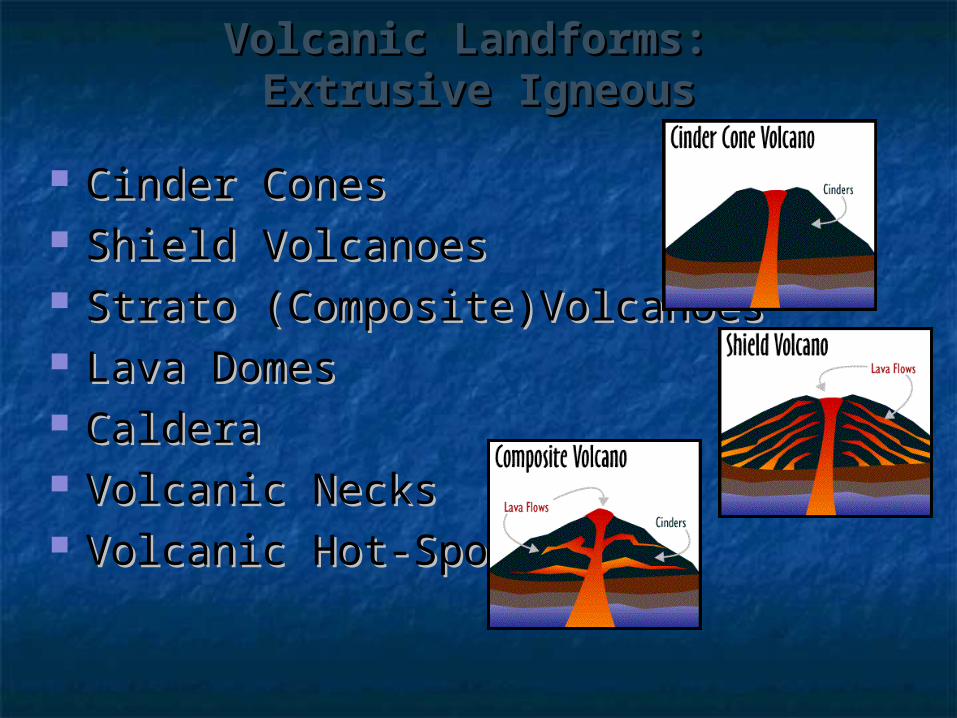
Volcanic Landforms: Volcanic Landforms: Extrusive IgneousExtrusive Igneous
Cinder ConesCinder Cones Shield VolcanoesShield Volcanoes Strato (Composite)VolcanoesStrato (Composite)Volcanoes Lava DomesLava Domes CalderaCaldera Volcanic NecksVolcanic Necks Volcanic Hot-SpotsVolcanic Hot-Spots
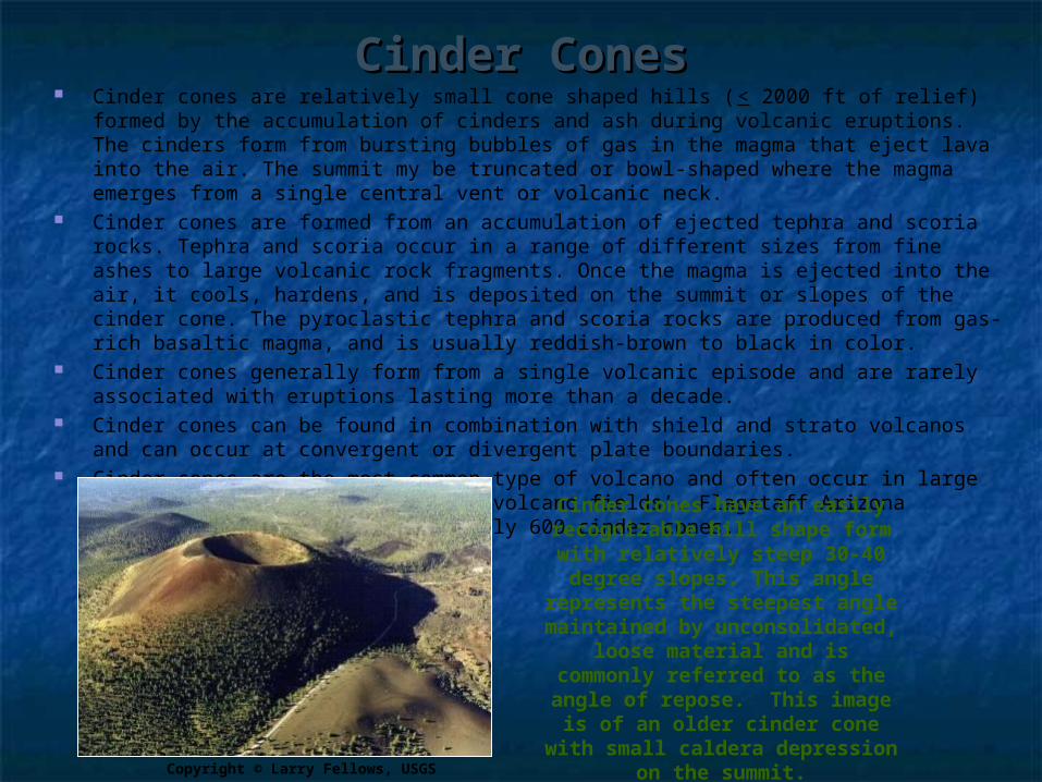
Cinder ConesCinder Cones Cinder cones are relatively small cone shaped hills (< 2000 ft of relief) formed by the
accumulation of cinders and ash during volcanic eruptions. The cinders form from bursting bubbles of gas in the magma that eject lava into the air. The summit my be truncated or bowl-shaped where the magma emerges from a single central vent or volcanic neck.
Cinder cones are formed from an accumulation of ejected tephra and scoria rocks. Tephra and scoria occur in a range of different sizes from fine ashes to large volcanic rock fragments. Once the magma is ejected into the air, it cools, hardens, and is deposited on the summit or slopes of the cinder cone. The pyroclastic tephra and scoria rocks are produced from gas-rich basaltic magma, and is usually reddish-brown to black in color.
Cinder cones generally form from a single volcanic episode and are rarely associated with eruptions lasting more than a decade.
Cinder cones can be found in combination with shield and strato volcanos and can occur at convergent or divergent plate boundaries.
Cinder cones are the most common type of volcano and often occur in large numbers within a region forming ‘volcano fields’. Flagstaff Arizona contains a volcanic field of nearly 600 cinder cones.
Cinder cones have an easily recognizable hill shape form with relatively steep 30-40 degree slopes. This angle
represents the steepest angle maintained by unconsolidated,
loose material and is commonly referred to as the
angle of repose. This image is of an older cinder cone with small caldera depression on
the summit.Copyright © Larry Fellows, USGS
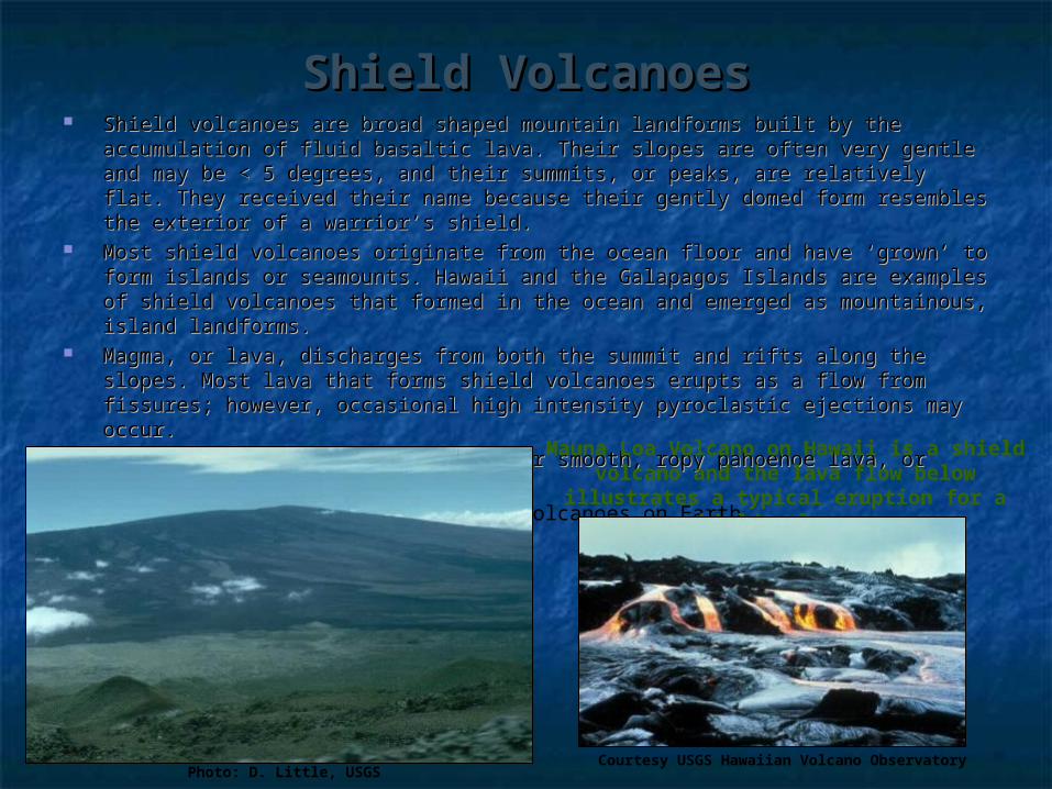
Shield VolcanoesShield Volcanoes Shield volcanoes are broad shaped mountain landforms built by the accumulation of Shield volcanoes are broad shaped mountain landforms built by the accumulation of
fluid basaltic lava. Their slopes are often very gentle and may be < 5 degrees, and fluid basaltic lava. Their slopes are often very gentle and may be < 5 degrees, and their summits, or peaks, are relatively flat. They received their name because their their summits, or peaks, are relatively flat. They received their name because their gently domed form resembles the exterior of a warrior’s shield. gently domed form resembles the exterior of a warrior’s shield.
Most shield volcanoes originate from the ocean floor and have ‘grown’ to form islands Most shield volcanoes originate from the ocean floor and have ‘grown’ to form islands or seamounts. Hawaii and the Galapagos Islands are examples of shield volcanoes or seamounts. Hawaii and the Galapagos Islands are examples of shield volcanoes that formed in the ocean and emerged as mountainous, island landforms. that formed in the ocean and emerged as mountainous, island landforms.
Magma, or lava, discharges from both the summit and rifts along the slopes. Most Magma, or lava, discharges from both the summit and rifts along the slopes. Most lava that forms shield volcanoes erupts as a flow from fissures; however, occasional lava that forms shield volcanoes erupts as a flow from fissures; however, occasional high intensity pyroclastic ejections may occur. high intensity pyroclastic ejections may occur.
Shield volcanoes usually have either smooth, ropy pahoehoe lava, or blocky, Shield volcanoes usually have either smooth, ropy pahoehoe lava, or blocky, sharp aa lava.
Shield volcanoes form the largest volcanoes on Earth.
Photo: D. Little, USGS
Mauna Loa Volcano on Hawaii is a shield volcano and the lava flow below
illustrates a typical eruption for a shield volcano.
Courtesy USGS Hawaiian Volcano Observatory
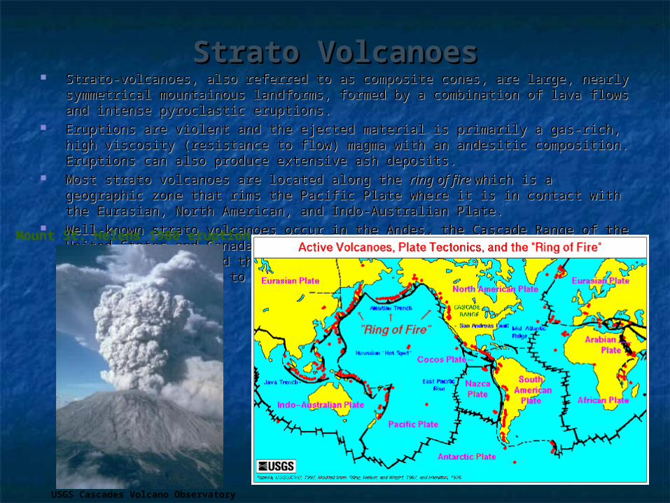
Strato VolcanoesStrato Volcanoes Strato-volcanoes, also referred to as composite cones, are large, nearly symmetrical Strato-volcanoes, also referred to as composite cones, are large, nearly symmetrical
mountainous landforms, formed by a combination of lava flows and intense mountainous landforms, formed by a combination of lava flows and intense pyroclastic eruptions. pyroclastic eruptions.
Eruptions are violent and the ejected material is primarily a gas-rich, high viscosity Eruptions are violent and the ejected material is primarily a gas-rich, high viscosity (resistance to flow) magma with an andesitic composition. Eruptions can also (resistance to flow) magma with an andesitic composition. Eruptions can also produce extensive ash deposits. produce extensive ash deposits.
Most strato volcanoes are located along the Most strato volcanoes are located along the ring of fire ring of fire which is a geographic zone which is a geographic zone that rims the Pacific Plate where it is in contact with the Eurasian, North American, that rims the Pacific Plate where it is in contact with the Eurasian, North American, and Indo-Australian Plate. and Indo-Australian Plate.
Well-known strato volcanoes occur in the Andes, the Cascade Range of the United Well-known strato volcanoes occur in the Andes, the Cascade Range of the United States and Canada (including Mount St. Helens, Mount Ranier, and Mount Garibaldi), States and Canada (including Mount St. Helens, Mount Ranier, and Mount Garibaldi), and the volcanic islands of the western Pacific from the Aleutian Islands to Japan, the and the volcanic islands of the western Pacific from the Aleutian Islands to Japan, the Philippines, and New Zealand. Philippines, and New Zealand.
USGS Cascades Volcano Observatory
Mount St. Helens 1980 eruption

CalderaCaldera Calderas are bowl-shaped collapse depressions formed by volcanic processes. Calderas are bowl-shaped collapse depressions formed by volcanic processes. Calderas most likely result from one of three collapse type events: Calderas most likely result from one of three collapse type events:
1. Collapse of the summit following an explosive eruption of silica-rich pumice and ash 1. Collapse of the summit following an explosive eruption of silica-rich pumice and ash pyroclastics pyroclastics
2. Collapse of the summit following the subterranean or fissure drainage of the magma chamber2. Collapse of the summit following the subterranean or fissure drainage of the magma chamber 3. Collapse of a large area following the discharge of silica-rich pumice and ash along ring 3. Collapse of a large area following the discharge of silica-rich pumice and ash along ring
fractures that may or may not have been previously active volcanoesfractures that may or may not have been previously active volcanoes Crater Lake in Oregon is an example of a 700 year old caldera that formed from the Crater Lake in Oregon is an example of a 700 year old caldera that formed from the
eruption and collapse of Mount Mazama. Today it is filed in with rainwater and forms a eruption and collapse of Mount Mazama. Today it is filed in with rainwater and forms a lake. A small cinder cone, named Wizard Island, formed inside the caldera and today it lake. A small cinder cone, named Wizard Island, formed inside the caldera and today it emerges as an island in the lake.emerges as an island in the lake.
Many of the calderas on Hawaiian volcanoes formed after the magma drained through Many of the calderas on Hawaiian volcanoes formed after the magma drained through fissures in the central magma chamber and the summit eventually collapses.fissures in the central magma chamber and the summit eventually collapses.
Yellowstone National Park contains a caldera that is >43 miles across and was formed Yellowstone National Park contains a caldera that is >43 miles across and was formed by an intense pyroclastic eruption that ejected ash fragments as far as the gulf of by an intense pyroclastic eruption that ejected ash fragments as far as the gulf of Mexico.Mexico. Crater Lake in Oregon
is the collapsed caldera of Mount Mazama and
is now filled in with water. Wizard Island is a volcanic cone in the
middle of the lake. Crater Lake is the
deepest lake in the United States at 1,932
feet deep! Copyright Larry Fellows, USGS
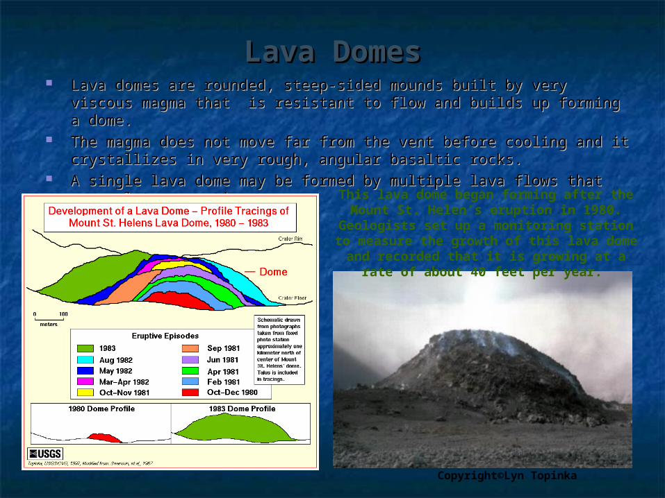
Lava DomesLava Domes Lava domes are rounded, steep-sided mounds built by very viscous Lava domes are rounded, steep-sided mounds built by very viscous
magma that is resistant to flow and builds up forming a dome. magma that is resistant to flow and builds up forming a dome. The magma does not move far from the vent before cooling and it The magma does not move far from the vent before cooling and it
crystallizes in very rough, angular basaltic rocks. crystallizes in very rough, angular basaltic rocks. A single lava dome may be formed by multiple lava flows that accumulate A single lava dome may be formed by multiple lava flows that accumulate
over time.over time.
Copyright©Lyn Topinka
This lava dome began forming after the Mount St. Helen’s eruption in 1980.
Geologists set up a monitoring station to measure the growth of this lava dome and
recorded that it is growing at a rate of about 40 feet per year.
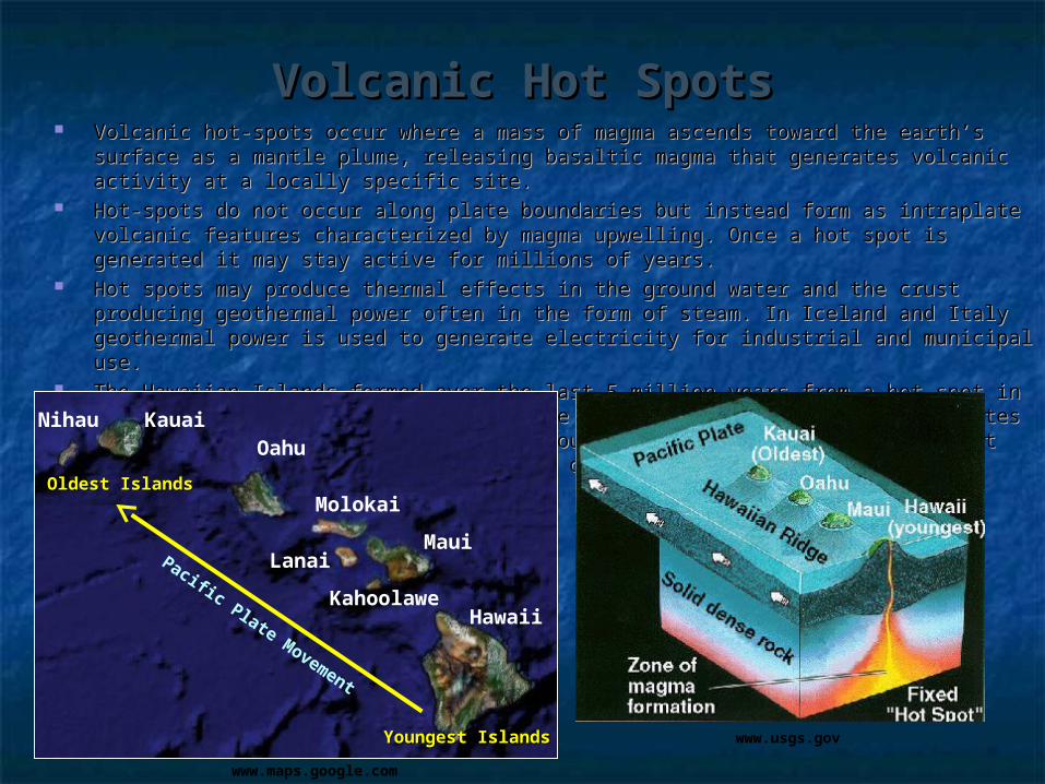
Volcanic Hot SpotsVolcanic Hot Spots Volcanic hot-spots occur where a mass of magma ascends toward the earth’s surface as a Volcanic hot-spots occur where a mass of magma ascends toward the earth’s surface as a
mantle plume, releasing basaltic magma that generates volcanic activity at a locally mantle plume, releasing basaltic magma that generates volcanic activity at a locally specific site.specific site.
Hot-spots do not occur along plate boundaries but instead form as intraplate volcanic Hot-spots do not occur along plate boundaries but instead form as intraplate volcanic features characterized by magma upwelling. Once a hot spot is generated it may stay features characterized by magma upwelling. Once a hot spot is generated it may stay active for millions of years. active for millions of years.
Hot spots may produce thermal effects in the ground water and the crust producing Hot spots may produce thermal effects in the ground water and the crust producing geothermal power often in the form of steam. In Iceland and Italy geothermal power is geothermal power often in the form of steam. In Iceland and Italy geothermal power is used to generate electricity for industrial and municipal use.used to generate electricity for industrial and municipal use.
The Hawaiian Islands formed over the last 5 million years from a hot spot in the Pacific The Hawaiian Islands formed over the last 5 million years from a hot spot in the Pacific Ocean. As the Pacific plate moves over the hotspot, it generates a chain of islands that Ocean. As the Pacific plate moves over the hotspot, it generates a chain of islands that emerge as seamounts above the ocean’s surface. Hot spot activity is currently most active emerge as seamounts above the ocean’s surface. Hot spot activity is currently most active on the big island, Hawaii. on the big island, Hawaii.
KauaiOahu
Maui
HawaiiKahoolawe
Lanai
Molokai
Nihau
Pacific Plate Movement
Oldest IslandsOldest Islands
Youngest IslandsYoungest Islands www.usgs.gov
www.maps.google.com
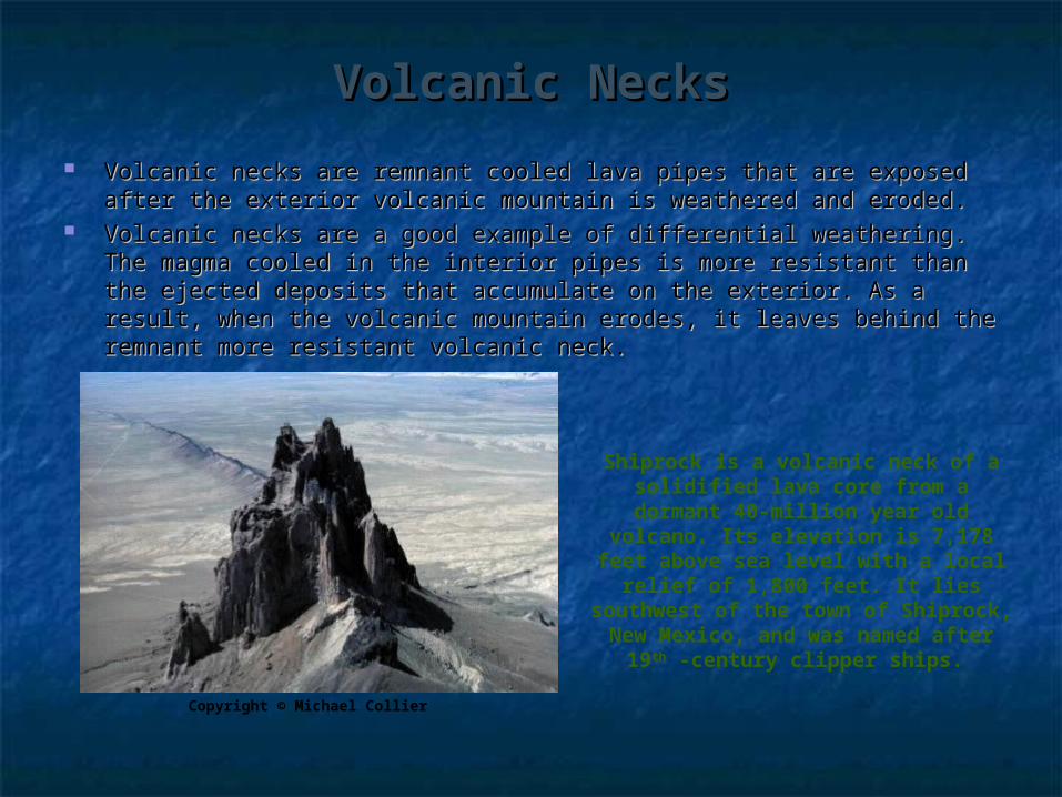
Volcanic NecksVolcanic Necks
Volcanic necks are remnant cooled lava pipes that are exposed after the Volcanic necks are remnant cooled lava pipes that are exposed after the exterior volcanic mountain is weathered and eroded. exterior volcanic mountain is weathered and eroded.
Volcanic necks are a good example of differential weathering. The magma Volcanic necks are a good example of differential weathering. The magma cooled in the interior pipes is more resistant than the ejected deposits that cooled in the interior pipes is more resistant than the ejected deposits that accumulate on the exterior. As a result, when the volcanic mountain erodes, accumulate on the exterior. As a result, when the volcanic mountain erodes, it leaves behind the remnant more resistant volcanic neck. it leaves behind the remnant more resistant volcanic neck.
Shiprock is a volcanic neck of a solidified lava core from a dormant
40-million year old volcano. Its elevation is 7,178 feet above sea
level with a local relief of 1,800 feet. It lies southwest of the town of Shiprock, New Mexico, and was
named after 19th -century clipper ships.
Copyright © Michael Collier
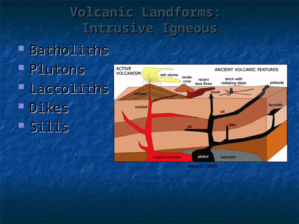
Volcanic Landforms: Volcanic Landforms: Intrusive IgneousIntrusive Igneous
Batholiths Batholiths Plutons Plutons LaccolithsLaccoliths DikesDikes SillsSills
Source: USGS
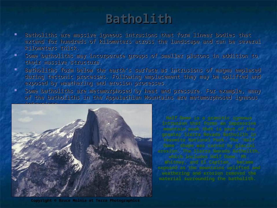
BatholithBatholith Batholiths are massive igneous intrusions that form linear bodies that extend for Batholiths are massive igneous intrusions that form linear bodies that extend for
hundreds of kilometers across the landscape and can be several kilometers thick.hundreds of kilometers across the landscape and can be several kilometers thick. Some batholiths may incorporate groups of smaller plutons in addition to their massive Some batholiths may incorporate groups of smaller plutons in addition to their massive
structure.structure. Batholiths form below the earth’s surface as intrusions of magma emplaced during Batholiths form below the earth’s surface as intrusions of magma emplaced during
tectonic processes. Following emplacement they may be uplifted and exposed by tectonic processes. Following emplacement they may be uplifted and exposed by weathering and erosion processes. weathering and erosion processes.
Some batholiths are metamorphosed by heat and pressure. For example, many of the Some batholiths are metamorphosed by heat and pressure. For example, many of the batholiths in the Appalachian Mountains are metamorphosed igneous intrusions. batholiths in the Appalachian Mountains are metamorphosed igneous intrusions.
Half Dome is a granitic igneous intrusion that forms an impressive mountain peak that is part of the greater Sierra Nevada Batholith in Yosemite National Park. The ‘Half
Dome’ shape was carved by glacial erosion. The Sierra Nevada Batholith,
which includes Half Dome, Mt. Whitney, and El Capitan, became
exposed as the mountains uplifted and weathering and erosion removed the material surrounding the batholith.
Copyright © Bruce Molnia at Terra Photographics
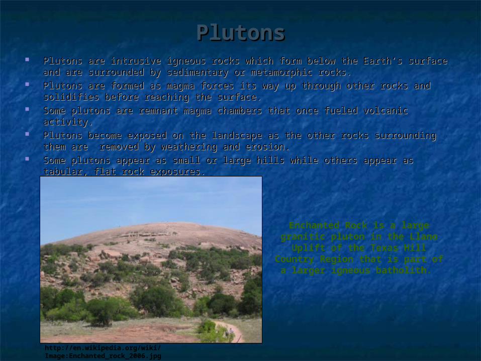
PlutonsPlutons Plutons are intrusive igneous rocks which form below the Earth’s surface and are Plutons are intrusive igneous rocks which form below the Earth’s surface and are
surrounded by sedimentary or metamorphic rocks. surrounded by sedimentary or metamorphic rocks. Plutons are formed as magma forces its way up through other rocks and solidifies Plutons are formed as magma forces its way up through other rocks and solidifies
before reaching the surface. before reaching the surface. Some plutons are remnant magma chambers that once fueled volcanic activity.Some plutons are remnant magma chambers that once fueled volcanic activity. Plutons become exposed on the landscape as the other rocks surrounding them are Plutons become exposed on the landscape as the other rocks surrounding them are
removed by weathering and erosion. removed by weathering and erosion. Some plutons appear as small or large hills while others appear as tabular, flat rock Some plutons appear as small or large hills while others appear as tabular, flat rock
exposures. exposures.
Enchanted Rock is a large granitic pluton in the Llano Uplift of the Texas Hill Country Region that is part of a larger igneous
batholith.
http://en.wikipedia.org/wiki/Image:Enchanted_rock_2006.jpg

Sills, Laccoliths, and DikesSills, Laccoliths, and Dikes Sills and laccoliths are igneous intrusions that form near the earth’s surface. They Sills and laccoliths are igneous intrusions that form near the earth’s surface. They
are concordant features meaning that they form parallel to existing strata or are concordant features meaning that they form parallel to existing strata or structures. structures.
Sills form near the surface from very fluid magma that cools quickly they are usually Sills form near the surface from very fluid magma that cools quickly they are usually mostly basaltic rocks with an aphanitic (fine-grained) texture.mostly basaltic rocks with an aphanitic (fine-grained) texture.
Laccoliths are similar to sills, accept they are formed by more viscous magma which Laccoliths are similar to sills, accept they are formed by more viscous magma which collects in a lens shape prior to cooling as a concordant igneous intrusion near the collects in a lens shape prior to cooling as a concordant igneous intrusion near the surface. This process may force the overlaying strata to form a slightly domed surface. This process may force the overlaying strata to form a slightly domed structure over the bulging laccolith. structure over the bulging laccolith.
Dikes are tabular intrusions of igneous rock that form when magma injects into Dikes are tabular intrusions of igneous rock that form when magma injects into fractures. Dikes are discordant features, meaning that they cut through layers of fractures. Dikes are discordant features, meaning that they cut through layers of rock. rock.
Magma can force the rock apart separating the fracture. Magma can force the rock apart separating the fracture. The cooled magma can range in thickness from centimeters to kilometers and may The cooled magma can range in thickness from centimeters to kilometers and may
be more resistant to erosion than the surrounding rocks enabling them to protrude be more resistant to erosion than the surrounding rocks enabling them to protrude outward amidst their surroundings.outward amidst their surroundings.
3434
Salisbury Craig is an exposed sill north of Edinburg, Scotland that
forms a resistant cap on this hill top.
http://en.wikipedia.org/wiki/sill
The dark linear feature in this
image is an exposed dike that is more resistant to
weathering and erosion than the
surrounding landscape.
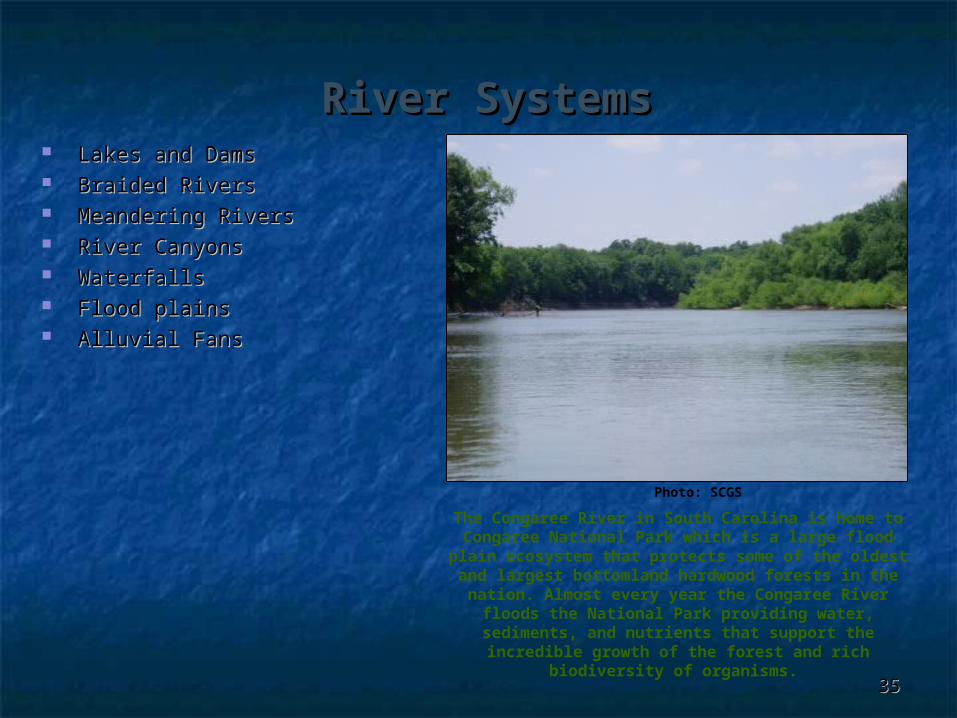
River SystemsRiver Systems Lakes and DamsLakes and Dams Braided RiversBraided Rivers Meandering RiversMeandering Rivers River CanyonsRiver Canyons WaterfallsWaterfalls Flood plainsFlood plains Alluvial FansAlluvial Fans
3535
The Congaree River in South Carolina is home to Congaree National Park which is a large flood plain
ecosystem that protects some of the oldest and largest bottomland hardwood forests in the nation.
Almost every year the Congaree River floods the National Park providing water, sediments, and
nutrients that support the incredible growth of the forest and rich biodiversity of organisms.
Photo: SCGS

Dams and LakesDams and Lakes
3636
Dams are control structures on rivers which store and release river water from a lake (reservoir) according to specific operating regimes.
Some dams are run-of-river structures which continually release the same amount of water entering the reservoir, while others are operated as storage facilities for regulated control on water releases.
Although 70 percent of the earth is covered with water, only about 2.5 percent is freshwater, by building dams with reservoirs people are able to store the freshwater and use it as needed.
Dams provide water for drinking, irrigation, hydro-electric power, river navigation, flood control, recreation, and many other needs.
Dams disconnect river channels and can function as local base level controls on stream gradient and store sediment from transporting downstream. They also act as barriers to migrating species, such as fish traveling upstream to spawn, and the controlled water releases alter the downstream ecology of river systems and their floodplains.
Lake Powell and Glen Canyon Dam: Lake Powell and Glen Canyon Dam: Colorado River, ArizonaColorado River, Arizona
Photo: Paul R. Kucher
Lake Murray and Saluda Dam:Lake Murray and Saluda Dam: Saluda River, South Carolina Saluda River, South Carolina
www.sceg.com
Standards: 3-3.5, 3-3.6, 3-3.8Standards: 5-3.1Standards: 8-3.7, 8-3.9
Table of Contents
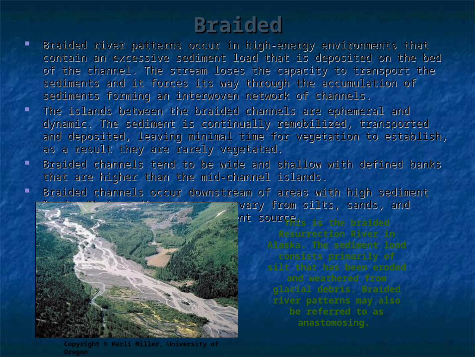
BraidedBraided Braided river patterns occur in high-energy environments that contain an Braided river patterns occur in high-energy environments that contain an
excessive sediment load that is deposited on the bed of the channel. The excessive sediment load that is deposited on the bed of the channel. The stream loses the capacity to transport the sediments and it forces its way stream loses the capacity to transport the sediments and it forces its way through the accumulation of sediments forming an interwoven network of through the accumulation of sediments forming an interwoven network of channels.channels.
The islands between the braided channels are ephemeral and dynamic. The The islands between the braided channels are ephemeral and dynamic. The sediment is continually remobilized, transported and deposited, leaving sediment is continually remobilized, transported and deposited, leaving minimal time for vegetation to establish, as a result they are rarely minimal time for vegetation to establish, as a result they are rarely vegetated. vegetated.
Braided channels tend to be wide and shallow with defined banks that are Braided channels tend to be wide and shallow with defined banks that are higher than the mid-channel islands. higher than the mid-channel islands.
Braided channels occur downstream of areas with high sediment loads. Their Braided channels occur downstream of areas with high sediment loads. Their sediment textures vary from silts, sands, and gravels depending on the sediment textures vary from silts, sands, and gravels depending on the sediment source. sediment source.
Copyright © Marli Miller, University of Oregon
This is the braided Resurrection River in
Alaska. The sediment load consists primarily of silt
that has been eroded and weathered from glacial
debris. Braided river patterns may also be
referred to as anastomosing.

MeanderingMeandering Meandering river patterns are low-gradient, sinuous channels that contain Meandering river patterns are low-gradient, sinuous channels that contain
multiple, individual meander bends that are laterally migrating across the multiple, individual meander bends that are laterally migrating across the flood plain.flood plain.
As they migrate or move across the flood plain they are continuously As they migrate or move across the flood plain they are continuously eroding, transporting, and depositing alluvial sediments. eroding, transporting, and depositing alluvial sediments.
Meandering rivers and their hydrologic conditions create a variety of Meandering rivers and their hydrologic conditions create a variety of depositional and erosional landform features that collectively form the flood depositional and erosional landform features that collectively form the flood plain valley.plain valley.
The primary features of meandering channels are the aggrading pointbar The primary features of meandering channels are the aggrading pointbar deposit on the inside of a meander bend and eroding cut bank along the deposit on the inside of a meander bend and eroding cut bank along the outside of the bend. As the channel migrates laterally across the flood plain, outside of the bend. As the channel migrates laterally across the flood plain, sediments are eroded from the outer cutbank and deposited on the inner sediments are eroded from the outer cutbank and deposited on the inner pointbar. pointbar.
Occasionally, meandering channels cut-off entire meander bends; these cut-Occasionally, meandering channels cut-off entire meander bends; these cut-offs are incorporated into the flood plain as oxbow lakes or in-filled channels. offs are incorporated into the flood plain as oxbow lakes or in-filled channels.
This is an aerial view of the meandering Congaree River and flood plain in Congaree National Park, South Carolina. This image
uses infrared colors instead of true colors; the infrared reflectance
causes healthy vegetation to show up as a reddish-pink color, instead of the green we expect to see. The
bottom right of the image includes a recently cut off meander bend and
oxbow lake.2006 Aerial imagery: http://www.dnr.sc.gov/GIS/gisdata.html

Flood plainsFlood plains Flood plains are the landform adjacent Flood plains are the landform adjacent
to the river channel that is influenced to the river channel that is influenced by modern river processes. Flood by modern river processes. Flood plains are constructive, depositional plains are constructive, depositional landforms created by stream flow and landforms created by stream flow and sediment deposition. sediment deposition.
Flood plain environments are Flood plain environments are composed of a mosaic of different composed of a mosaic of different landform features including landform features including cutbankscutbanks, , pointbarspointbars, , natural natural leveeslevees, , crevasse channels crevasse channels and and crevasse splayscrevasse splays, , infilled channels infilled channels and and oxbow lakesoxbow lakes, , backswamps, and , and occasionally yazoo tributaries and occasionally yazoo tributaries and other flood plain channels.other flood plain channels.
Copyright ©2008 Google
This aerial view of the Mississippi River Valley contains many typical floodplain features. The darker, green areas are
floodplain forest and they likely flood the most frequently and thus are not
developed with agriculture or housing. The surrounding patchwork represents agricultural fields and other developed
lands that are probably at a higher elevation formed by natural or artificial
levees.
PointbarPointbar
CutbankCutbank
Oxbow Oxbow LakesLakes
Infilled Infilled Channel Channel
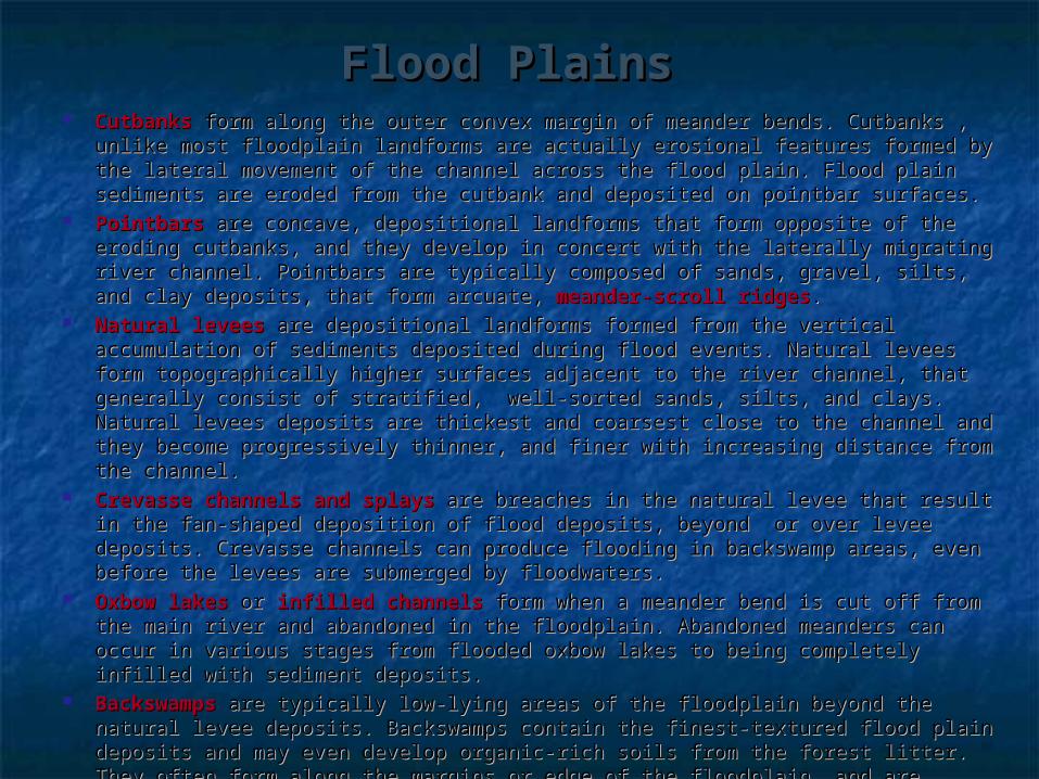
Flood PlainsFlood Plains Cutbanks Cutbanks form along the outer convex margin of meander bends. Cutbanks , unlike form along the outer convex margin of meander bends. Cutbanks , unlike
most floodplain landforms are actually erosional features formed by the lateral most floodplain landforms are actually erosional features formed by the lateral movement of the channel across the flood plain. Flood plain sediments are eroded from movement of the channel across the flood plain. Flood plain sediments are eroded from the cutbank and deposited on pointbar surfaces.the cutbank and deposited on pointbar surfaces.
Pointbars Pointbars are concave, depositional landforms that form opposite of the eroding are concave, depositional landforms that form opposite of the eroding cutbanks, and they develop in concert with the laterally migrating river channel. cutbanks, and they develop in concert with the laterally migrating river channel. Pointbars are typically composed of sands, gravel, silts, and clay deposits, that form Pointbars are typically composed of sands, gravel, silts, and clay deposits, that form arcuate, arcuate, meander-scroll ridgesmeander-scroll ridges. .
Natural levees Natural levees are depositional landforms formed from the vertical accumulation of are depositional landforms formed from the vertical accumulation of sediments deposited during flood events. Natural levees form topographically higher sediments deposited during flood events. Natural levees form topographically higher surfaces adjacent to the river channel, that generally consist of stratified, well-sorted surfaces adjacent to the river channel, that generally consist of stratified, well-sorted sands, silts, and clays. Natural levees deposits are thickest and coarsest close to the sands, silts, and clays. Natural levees deposits are thickest and coarsest close to the channel and they become progressively thinner, and finer with increasing distance from channel and they become progressively thinner, and finer with increasing distance from the channel. the channel.
Crevasse channels and splaysCrevasse channels and splays are breaches in the natural levee that result in the fan-are breaches in the natural levee that result in the fan-shaped deposition of flood deposits, beyond or over levee deposits. Crevasse channels shaped deposition of flood deposits, beyond or over levee deposits. Crevasse channels can produce flooding in backswamp areas, even before the levees are submerged by can produce flooding in backswamp areas, even before the levees are submerged by floodwaters. floodwaters.
Oxbow lakes Oxbow lakes or or infilled channels infilled channels form when a meander bend is cut off from the main form when a meander bend is cut off from the main river and abandoned in the floodplain. Abandoned meanders can occur in various stages river and abandoned in the floodplain. Abandoned meanders can occur in various stages from flooded oxbow lakes to being completely infilled with sediment deposits. from flooded oxbow lakes to being completely infilled with sediment deposits.
Backswamps Backswamps are typically low-lying areas of the floodplain beyond the natural levee are typically low-lying areas of the floodplain beyond the natural levee deposits. Backswamps contain the finest-textured flood plain deposits and may even deposits. Backswamps contain the finest-textured flood plain deposits and may even develop organic-rich soils from the forest litter. They often form along the margins or develop organic-rich soils from the forest litter. They often form along the margins or edge of the floodplain, and are usually influenced by connections to the groundwater. edge of the floodplain, and are usually influenced by connections to the groundwater.
Yazoo tributaries Yazoo tributaries are stream networks that enter the floodplain but the natural levee are stream networks that enter the floodplain but the natural levee prevents the stream from flowing into the river. As a result the yazoo tributary flows prevents the stream from flowing into the river. As a result the yazoo tributary flows parallel to the mainstem river before reaching a breach in the levee or occupying the parallel to the mainstem river before reaching a breach in the levee or occupying the course of an abandoned meander that allows the stream to cross the levee deposits and course of an abandoned meander that allows the stream to cross the levee deposits and flow into the river. flow into the river.
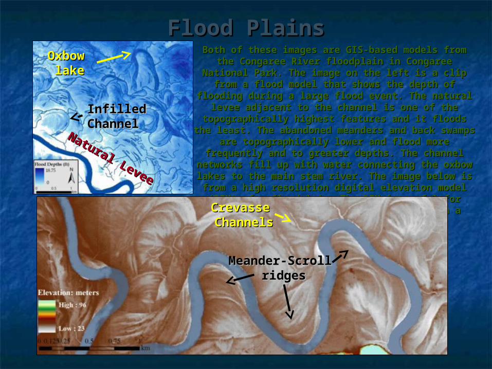
Flood PlainsFlood PlainsBoth of these images are GIS-based models from Both of these images are GIS-based models from
the Congaree River floodplain in Congaree National the Congaree River floodplain in Congaree National Park. The image on the left is a clip from a flood Park. The image on the left is a clip from a flood model that shows the depth of flooding during a model that shows the depth of flooding during a
large flood event. The natural levee adjacent to the large flood event. The natural levee adjacent to the channel is one of the topographically highest channel is one of the topographically highest
features and it floods the least. The abandoned features and it floods the least. The abandoned meanders and back swamps are topographically meanders and back swamps are topographically lower and flood more frequently and to greater lower and flood more frequently and to greater depths. The channel networks fill up with water depths. The channel networks fill up with water
connecting the oxbow lakes to the main stem river. connecting the oxbow lakes to the main stem river. The image below is from a high resolution digital The image below is from a high resolution digital elevation model (DEM) of a floodplain. The DEM is elevation model (DEM) of a floodplain. The DEM is useful for mapping the different landform features useful for mapping the different landform features
on a floodplain.on a floodplain.
Oxbow Oxbow lakelake
Infilled Infilled ChannelChannel
Natural Levee
Natural Levee
Crevasse Crevasse ChannelsChannels
Meander-Scroll Meander-Scroll ridgesridges

River TerracesRiver Terraces River terraces are older remnant flood plain surfaces that are higher in River terraces are older remnant flood plain surfaces that are higher in
elevation than the modern flood plain. They may occur on one or both sides elevation than the modern flood plain. They may occur on one or both sides of the valley.of the valley.
Terraces are formed when the river channel cuts down into the flood plain Terraces are formed when the river channel cuts down into the flood plain and laterally erodes the alluvial valley, carving a new river channel and flood and laterally erodes the alluvial valley, carving a new river channel and flood plain entrenched within the older flood plain surfaces. Down cutting can plain entrenched within the older flood plain surfaces. Down cutting can occur because of hydrologic or sedimentary changes in the headwaters or occur because of hydrologic or sedimentary changes in the headwaters or valley gradient changes caused by a retreating sea-level and lowered or valley gradient changes caused by a retreating sea-level and lowered or extended base-level. Terraces can also form from tectonics and valley extended base-level. Terraces can also form from tectonics and valley uplifting.uplifting.
Terraces are generally isolated from the more recent river processes and Terraces are generally isolated from the more recent river processes and may only flood during 100 or 500 year flood events. River terraces are often may only flood during 100 or 500 year flood events. River terraces are often archeological hot spots because they contain artifacts from historic colonies archeological hot spots because they contain artifacts from historic colonies that used the river and flood plain.that used the river and flood plain. This river has gone through This river has gone through
several different episodes of several different episodes of down cutting and rejuvenation. down cutting and rejuvenation.
The modern flood plain is The modern flood plain is preceded by four different preceded by four different
terraces that all reflect distinct terraces that all reflect distinct periods of environmental periods of environmental
conditions or valley gradients, conditions or valley gradients, each different from the other. each different from the other.
Over time, it is possible that the Over time, it is possible that the river will down-cut again river will down-cut again
abandoning a fifth terrace. abandoning a fifth terrace.
Copyright©Louis Maher, University of Wisconsin
Terrace 1Terrace 1
Terrace 2Terrace 2
Terrace 3Terrace 3
River Channel and Modern Flood River Channel and Modern Flood PlainPlain
Terrace 4Terrace 4

WaterfallsWaterfalls Waterfalls occur where there is resistant bedrock, abrupt changes in bedrock Waterfalls occur where there is resistant bedrock, abrupt changes in bedrock
resistance, or along fractures or faults in the bedrock. resistance, or along fractures or faults in the bedrock. Less resistant materials are weathered more quickly than resistant rocks, creating Less resistant materials are weathered more quickly than resistant rocks, creating
stair-stepped ledges or drop offs where waterfalls occur. Less resistant rocks may stair-stepped ledges or drop offs where waterfalls occur. Less resistant rocks may also form pools between resistant rocks that form waterfalls. also form pools between resistant rocks that form waterfalls.
Faults and fractures often provide natural pathways for the downslope movement of Faults and fractures often provide natural pathways for the downslope movement of water. water.
The location of the waterfalls origin may be referred to as a “knick-point”, continued The location of the waterfalls origin may be referred to as a “knick-point”, continued weathering by the stream flow causes the knick-point to slowly migrate upstream. weathering by the stream flow causes the knick-point to slowly migrate upstream.
Most waterfalls in South Carolina occur along streams in the Blue Ridge, Piedmont, Most waterfalls in South Carolina occur along streams in the Blue Ridge, Piedmont, and the along the Regional Fall Line where there are rock layers of varying and the along the Regional Fall Line where there are rock layers of varying resistance.resistance.
Copyright Copyright © Marli Miller, University of Oregon© Marli Miller, University of Oregon
This waterfall was formed by differential This waterfall was formed by differential weathering between the softer shale and weathering between the softer shale and
harder more resistant limestone. harder more resistant limestone.
Photo: SCGS
Lower White Water Lower White Water Falls in the Jocassee Falls in the Jocassee
Gorges area of Gorges area of South Carolina South Carolina
drops nearly 200 ft. drops nearly 200 ft. Here, the Toxaway Here, the Toxaway
Gneiss forms a Gneiss forms a resistant bedrock resistant bedrock
that the Lower that the Lower White Water River White Water River flows over before flows over before draining into Lake draining into Lake
Jocasse. Jocasse.

Alluvial FansAlluvial Fans Alluvial fans are fan-shaped fluvial deposits that accumulate at the Alluvial fans are fan-shaped fluvial deposits that accumulate at the
base of stream where it flows out from a steep gradient and base of stream where it flows out from a steep gradient and enters into a lower-gradient flood plain or valley setting.enters into a lower-gradient flood plain or valley setting.
The stream enters the valley carrying a higher capacity sediment The stream enters the valley carrying a higher capacity sediment load than it can continue to carry, and as a result it deposits the load than it can continue to carry, and as a result it deposits the sediments as an alluvial fan.sediments as an alluvial fan.
Alluvial fans generally form in arid environments with a high Alluvial fans generally form in arid environments with a high sediment load and where there is minimal vegetation to disrupt sediment load and where there is minimal vegetation to disrupt the fan formation. the fan formation.
Alluvial fans may form from a single high-flow event or from the Alluvial fans may form from a single high-flow event or from the accumulation of multiple events. accumulation of multiple events.
Copyright © Marli Miller, University of Oregon
This alluvial fan is carrying a high This alluvial fan is carrying a high sediment load from material weathered sediment load from material weathered from the mountains. The dark line along from the mountains. The dark line along
the edge of the fan is a road. Because the the edge of the fan is a road. Because the road is not buried by recent deposits it road is not buried by recent deposits it suggest that this fan is not currently as suggest that this fan is not currently as
active as it was in the past.active as it was in the past.

Coastal LandformsCoastal Landforms
Littoral ZoneLittoral Zone BeachesBeaches Barrier IslandsBarrier Islands Beach RidgesBeach Ridges SpitsSpits DeltasDeltas Coastal CliffsCoastal Cliffs Marine TerracesMarine Terraces Wave-Cut ScarpsWave-Cut Scarps
Hawaiian coastline
Photo source: SCGS
Coastal landforms include a diverse array of shoreline and near-shoreline features, as well as some coastal plain landforms far removed from the modern ocean by long term sea-level changes. This section will explore both constructive and destructive landforms formed by current coastal processes, as well as marine related landforms that were formed during periods of higher sea level.
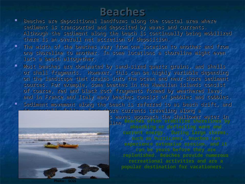
BeachesBeaches Beaches are depositional landforms along the coastal area where sediment is Beaches are depositional landforms along the coastal area where sediment is
transported and deposited by waves and currents. Although the sediment transported and deposited by waves and currents. Although the sediment along the beach is continually being mobilized there is an overall net accretion along the beach is continually being mobilized there is an overall net accretion of deposition.of deposition.
The width of the beaches vary from one location to another and from one The width of the beaches vary from one location to another and from one shoreline to another. In some locations a shoreline might even lack a beach shoreline to another. In some locations a shoreline might even lack a beach altogether. altogether.
Most beaches are dominated by sand-sized quartz grains, and shells or shell Most beaches are dominated by sand-sized quartz grains, and shells or shell fragments. However, this can be highly variable depending on the landscape fragments. However, this can be highly variable depending on the landscape that drains into the ocean and near-shore sediment sources. For example, that drains into the ocean and near-shore sediment sources. For example, some beaches in the Hawaiian islands consist of coarse, red and black rock some beaches in the Hawaiian islands consist of coarse, red and black rock fragments formed by weathered lava; and in France and Italy many beaches fragments formed by weathered lava; and in France and Italy many beaches consist of pebbles and cobbles.consist of pebbles and cobbles.
Sediment movement along the beach is referred to as beach drift, and it Sediment movement along the beach is referred to as beach drift, and it generally follows long shore currents traveling along a directional trend generally follows long shore currents traveling along a directional trend produced as waves approach the shallower water in the surf zone near the produced as waves approach the shallower water in the surf zone near the shoreline. shoreline.
Photo: SCGS
Beaches often stabilize shorelines by absorbing or deflecting wave and current
energy. During large storms, such as hurricanes, beaches can experience
extensive erosion, and it can be years before they are replenished. Beaches
provide numerous recreational activities and are a popular destination for
vacationers.

Barrier IslandsBarrier Islands Barrier islands, also referred to as barrier beaches, are long, narrow, Barrier islands, also referred to as barrier beaches, are long, narrow,
depositional landforms, that form parallel to the coastline and may or may not depositional landforms, that form parallel to the coastline and may or may not connect to the mainland. They are the first line of protection against hurricane connect to the mainland. They are the first line of protection against hurricane storm surge.storm surge.
They are generally composed of quartz sands, and they form along coasts They are generally composed of quartz sands, and they form along coasts where there is a substantial supply of sand entering the ocean from Coastal where there is a substantial supply of sand entering the ocean from Coastal Plain rivers. Plain rivers.
Barrier islands often form where tidal process are minimal.Barrier islands often form where tidal process are minimal. The landward side of the barrier islands may contain tidal flats, marshes, The landward side of the barrier islands may contain tidal flats, marshes,
swamps, lagoons, coastal dunes, and beaches. swamps, lagoons, coastal dunes, and beaches. Similar to beaches, barrier islands form in relation to, long-shore current Similar to beaches, barrier islands form in relation to, long-shore current
processes and overtime adjust to sea-level changes.processes and overtime adjust to sea-level changes. Classic examples of barrier islands include North Carolina’s Outer Banks and Classic examples of barrier islands include North Carolina’s Outer Banks and
Texas’s Padre Island. Both of these barrier islands have National Park Service Texas’s Padre Island. Both of these barrier islands have National Park Service lands that preserve natural coastal processes and protect plant and wildlife lands that preserve natural coastal processes and protect plant and wildlife habitat from human impacts.habitat from human impacts.
Image: NOAA

DeltasDeltas Deltas form where the mouth of a river meets its ultimate base level at the
ocean or sea. As the river’s velocity decreases, it looses the capacity to carry its sediment load and the resulting deposits form a delta. Delta shapes and forms vary depending on tidal influences, waves, currents, sediment type and quantity, river discharge, and the stream gradient near the outlet. The most common types of deltas include bird-foot, estuarine, and arcuate.
Not all rivers form deltas, for example the Amazon deposits its sediment load directly into the ocean onto an underwater seaward sloping continental shelf. The Columbia River in the northwest United States, lacks a delta altogether, because the currents are too strong and erosive for the sediments to deposit. Mississippi River Delta: Bird-Foot Delta A bird-foot delta contains a large
channel with multiple smaller distributary channels draining off
from the main channel and depositing sediments. They generally form with rivers that have a high sediment load and flow into an area with minimal
tidal influences. This false-color infrared image provides a satellite view of the Mississippi River delta.
This delta has shifted positions several times over the last 5000
years in relation to changes in the Mississippi River. Scientist recognize
atleast 7 distinct deltas. The most recent began forming 500 years ago and forms a classic bird-foot delta.
DeltasDeltas
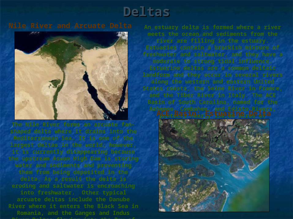
The Nile River forms an arcuate fan-shaped delta where it drains into the Mediterranean Sea. It is one of the
largest deltas in the world; however, it is currently disappearing because the upstream Aswan High Dam is storing water and sediments and preventing
them from being deposited in the delta. As a result the delta is eroding and
saltwater is encroaching into freshwater. Other typical arcuate
deltas include the Danube River where it enters the Black Sea in Romania, and
the Ganges and Indus River Deltas flowing into the Bay of Bengal.
Nile River and Arcuate Delta An estuary delta is formed where a river meets the ocean and sediments from the river are filling in the estuary. Estuaries contain a brackish mixture of freshwater
and saltwater, and they have a moderate to strong tidal influence. Estuarine deltas are a common deltaic landform and they occur in
several rivers along the western and eastern United States coasts, the Seine River in
France, and the Tiber River in Italy. The ACE Basin of South Carolina, named for the Ashepoo, Combahee, and Edisto Rivers,
protects nearly 150,00 acres of undeveloped estuary habitat. ACE Basin: Estuarine Delta
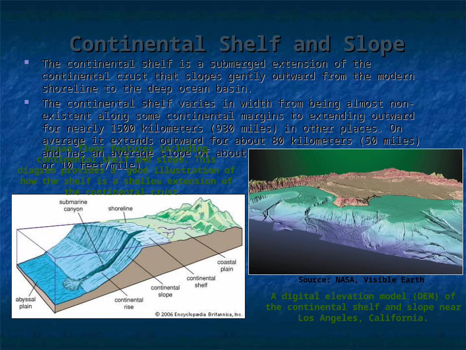
Continental Shelf and SlopeContinental Shelf and Slope The continental shelf is a submerged extension of the continental crust that The continental shelf is a submerged extension of the continental crust that
slopes gently outward from the modern shoreline to the deep ocean basin. slopes gently outward from the modern shoreline to the deep ocean basin. The continental shelf varies in width from being almost non-existent along The continental shelf varies in width from being almost non-existent along
some continental margins to extending outward for nearly 1500 kilometers some continental margins to extending outward for nearly 1500 kilometers (930 miles) in other places. On average it extends outward for about 80 (930 miles) in other places. On average it extends outward for about 80 kilometers (50 miles) and has an average slope of about 1 degree (2 kilometers (50 miles) and has an average slope of about 1 degree (2 meters/kilometer or 10 feet/mile).meters/kilometer or 10 feet/mile).
Ocean floor features including continental shelf and slope. This diagram provides a
good illustration of how the shelf is a shallow extension of the continental crust.
A digital elevation model (DEM) of the continental shelf and slope near Los
Angeles, California.
Source: NASA, Visible Earth
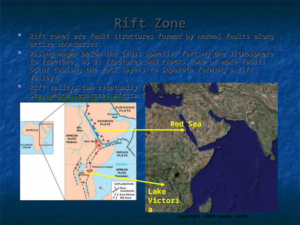
Rift ZoneRift Zone Rift zones are fault structures formed by normal faults along active Rift zones are fault structures formed by normal faults along active
boundaries.boundaries. Rising magma below the crust upwells, forcing the lithosphere to fracture, Rising magma below the crust upwells, forcing the lithosphere to fracture,
as it fractures and cracks, one or more faults occur causing the rock layers as it fractures and cracks, one or more faults occur causing the rock layers to separate forming a rift valley. to separate forming a rift valley.
Rift valleys can eventually form lakes or seas such as the Red Sea, which Rift valleys can eventually form lakes or seas such as the Red Sea, which separates Africa from the Arabian Peninsula. separates Africa from the Arabian Peninsula.
Rift Valleys in Africa
Copyright ©2008 Google Earth
Red Sea
Lake Victoria
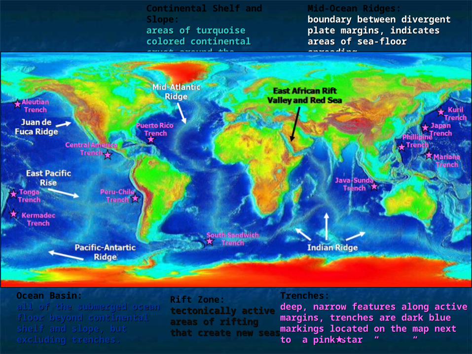
Continental Shelf and Slope:areas of turquoise areas of turquoise colored continental crust colored continental crust around the continental around the continental marginsmargins
Mid-Ocean Ridges: boundary between divergent boundary between divergent plate margins, indicates plate margins, indicates areas of sea-floor spreadingareas of sea-floor spreading
Trenches: deep, narrow features along active deep, narrow features along active margins, trenches are dark blue margins, trenches are dark blue markings located on the map next markings located on the map next to a pink star “ “ to a pink star “ “
Ocean Basin: all of the submerged ocean all of the submerged ocean floor beyond continental floor beyond continental shelf and slope, but shelf and slope, but excluding trenches.excluding trenches.
Rift Zone:tectonically active tectonically active areas of rifting that areas of rifting that create new seascreate new seas
Mid-Atlantic Mid-Atlantic RidgeRidge
Indian RidgeIndian Ridge
East African Rift East African Rift Valley and Red Valley and Red
SeaSea
East Pacific East Pacific RiseRise
Juan de Juan de Fuca RidgeFuca Ridge
Pacific-Antartic Pacific-Antartic RidgeRidge
Puerto Rico Puerto Rico TrenchTrench
AleutianAleutianTrenchTrench
TongaTongaTrenchTrench
KermadecKermadecTrenchTrench
Central AmericaCentral AmericaTrenchTrench
Peru-ChilePeru-ChileTrenchTrench
South SandwichSouth SandwichTrenchTrench
Java-SundaJava-SundaTrenchTrench
MarianaMarianaTrenchTrench
PhillipinePhillipineTrenchTrench
JapanJapanTrenchTrench
KurilKurilTrenchTrench
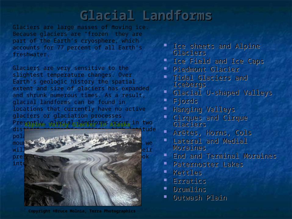
Glacial LandformsGlacial Landforms
Ice sheets and Alpine Ice sheets and Alpine GlaciersGlaciers
Ice Field and Ice CapsIce Field and Ice Caps Piedmont GlacierPiedmont Glacier Tidal Glaciers and IcebergsTidal Glaciers and Icebergs Glacial U-shaped ValleysGlacial U-shaped Valleys FjordsFjords Hanging ValleysHanging Valleys Cirques and Cirque GlaciersCirques and Cirque Glaciers ArArêêtes, Horns, Colstes, Horns, Cols Lateral and Medial Lateral and Medial
MorainesMoraines End and Terminal MorainesEnd and Terminal Moraines Paternoster LakesPaternoster Lakes KettlesKettles ErraticsErratics DrumlinsDrumlins Outwash PlainOutwash Plain
Glaciers are large masses of moving ice. Because glaciers are “frozen” they are part of the Earth’s cryosphere, which accounts for 77 percent of all Earth’s freshwater.
Glaciers are very sensitive to the slightest temperature changes. Over Earth’s geologic history the spatial extent and size of glaciers has expanded and shrunk numerous times. As a result, glacial landforms can be found in locations that currently have no active glaciers or glaciation processes. Presently, glacial landforms occur in two distinct geographic regions, high latitude polar environments and high altitude mountain environments. In this section we will explore glacial landforms from their present context and from a historic look into the past.
Copyright ©Bruce Molnia, Terra Photographics
Alpine Valley Glacier in Alaska.
GlaciersGlaciers Glaciers are large masses of “flowing” ice formed by the accumulation and compaction Glaciers are large masses of “flowing” ice formed by the accumulation and compaction
of recrystallized melted snow. of recrystallized melted snow. Glacial landforms are divided into two broad categories which occur in distinct Glacial landforms are divided into two broad categories which occur in distinct
geographic regions: geographic regions: ice sheets ice sheets which occur high latitude polar environments and which occur high latitude polar environments and alpine glaciers alpine glaciers which occur in high altitude mountain environments.which occur in high altitude mountain environments.
Ice sheetsIce sheets are high latitude polar glaciers that cover extensive areas of continental are high latitude polar glaciers that cover extensive areas of continental landmasses, for this reason they are also referred to as “landmasses, for this reason they are also referred to as “continental glacierscontinental glaciers”. ”. Glacial ice sheet formation requires long periods of extremely low temperatures, Glacial ice sheet formation requires long periods of extremely low temperatures, which allows snow to collect over vast areas covering the underlying terrain. The which allows snow to collect over vast areas covering the underlying terrain. The accumulation of snow forms dense layers that are thousands of meters thick. accumulation of snow forms dense layers that are thousands of meters thick. Antarctica and Greenland are both almost completely covered by glacial ice sheets. Antarctica and Greenland are both almost completely covered by glacial ice sheets.
Alpine glaciersAlpine glaciers are long, linear glaciers that occupy high altitude mountain are long, linear glaciers that occupy high altitude mountain valleys, for this reason they are also referred to as “valleys, for this reason they are also referred to as “valley glaciersvalley glaciers”. Alpine ”. Alpine glaciers flow down valley, and increase in size as they accumulate and absorb glaciers flow down valley, and increase in size as they accumulate and absorb smaller tributary glaciers from the mountainous terrain. Alpine glaciers can be found smaller tributary glaciers from the mountainous terrain. Alpine glaciers can be found all around the world, and presently occur in may of the major mountain ranges in all around the world, and presently occur in may of the major mountain ranges in the world including the Rockies, Andes, and Himalayas. Alpine glaciers may also the world including the Rockies, Andes, and Himalayas. Alpine glaciers may also occur in high-latitude, polar or arctic mountains, such as those in Alaska. occur in high-latitude, polar or arctic mountains, such as those in Alaska.
Geomorphologist’s often refer to glaciers as “rivers of ice” because like rivers, Geomorphologist’s often refer to glaciers as “rivers of ice” because like rivers, continental and alpine glaciers “flow” down-valley through the landscape eroding, continental and alpine glaciers “flow” down-valley through the landscape eroding, transporting, and depositing weathered materials along their the path. It is this transporting, and depositing weathered materials along their the path. It is this combination processes that forms the diverse array of constructive and destructive combination processes that forms the diverse array of constructive and destructive glacial landforms. glacial landforms.

Tidal Glaciers and IcebergsTidal Glaciers and Icebergs Tidal glaciers are the portion of either alpine or continental glaciers Tidal glaciers are the portion of either alpine or continental glaciers
which spill out into the sea and float on the surface of the saltwater.which spill out into the sea and float on the surface of the saltwater. The glacial ice over the water breaks by calving off into large icebergs. The glacial ice over the water breaks by calving off into large icebergs. Icebergs are large floating blocks of ice that calved off from tidal Icebergs are large floating blocks of ice that calved off from tidal
glaciers. glaciers. Icebergs usually calve off along crevasses or cracks in the ice, but can Icebergs usually calve off along crevasses or cracks in the ice, but can
also fail from a combination of melting and gravitational pull. also fail from a combination of melting and gravitational pull. Icebergs vary in size and thickness, and some reach heights more than Icebergs vary in size and thickness, and some reach heights more than
100 feet!100 feet!
The icebergs in the front of the photo calved of from the
tidal glacier in the background. The portion of the icebergs exposed above
the water is often only a third of their entire size, the
other two-thirds is submerged below the water.
Copyright ©Bruce Molnia, Terra Photographics

Glacial “U-Shaped” ValleysGlacial “U-Shaped” Valleys Glacial valleys are formed by the abrasive action of glacial ice as it Glacial valleys are formed by the abrasive action of glacial ice as it
slowly carves a “u-shaped” path through the mountainous valleys. slowly carves a “u-shaped” path through the mountainous valleys. Prior to the formation of the glacier, most valleys are initially formed as a Prior to the formation of the glacier, most valleys are initially formed as a
“v-shaped” stream valley eroded by flowing water. Once the valleys “v-shaped” stream valley eroded by flowing water. Once the valleys becomes occupied by the glacier, the glacial ice spreads from one side of becomes occupied by the glacier, the glacial ice spreads from one side of the valley to the other, completely filling in the valley floor and up the the valley to the other, completely filling in the valley floor and up the hill slopes. As the glaciers moves down-valley it abrasively erodes the hill slopes. As the glaciers moves down-valley it abrasively erodes the pre-formed “v-shaped” stream valley into a “u-shaped” glacial valley. pre-formed “v-shaped” stream valley into a “u-shaped” glacial valley.
5656
The Alaska's Woodworth Glacier, on the left is beginning to retreat and expose a
glacial u-shaped valley beneath the melting ice. The Sierra Nevada landscape with Yosemite Valley
pictured below, presently only contains glaciers in the highest elevations, but
many of the prominent u-shaped valleys, reveal past evidence of glacial
erosion.
Copyright ©Bruce Molnia, Terra PhotographicsSource: Wikimedia Commons

FjordsFjords Fjords are flooded troughs that form where glacial u-shaped valleys Fjords are flooded troughs that form where glacial u-shaped valleys
intersect the ocean and the sea floods inland filling up the valley. intersect the ocean and the sea floods inland filling up the valley. Fjords can form during active glaciation or post-glaciation depending on Fjords can form during active glaciation or post-glaciation depending on
sea-level. sea-level. When a glacier intersects the ocean, the glacier can continue to erode and When a glacier intersects the ocean, the glacier can continue to erode and
carve the valley below sea-level. The water that fills in above the glacier carve the valley below sea-level. The water that fills in above the glacier and floods the valley forms a fjord.and floods the valley forms a fjord.
Fjords can also form post-glaciation by rising sea-level or changes in Fjords can also form post-glaciation by rising sea-level or changes in elevation along the coastline from melting ice.elevation along the coastline from melting ice.
Copyright © Michael Collier, USGS
On the left is a glacier intersecting a fjord in the Pacific Ocean off Estero de las Montanas in Chile,
South America. Below is an aerial view of the Prince William Sound and Cascade Glacier fjord
in Alaska.
Copyright © 2008 Google

Hanging ValleysHanging Valleys Hanging valleys are abrupt, cliff-like features that are formed at the Hanging valleys are abrupt, cliff-like features that are formed at the
confluence where smaller tributary glaciers merge with larger valley glaciers.confluence where smaller tributary glaciers merge with larger valley glaciers. The scour of the larger glacier carves the valley into a u-shape, removing the The scour of the larger glacier carves the valley into a u-shape, removing the
original gradient of the tributary confluence, as a result the tributary valley is original gradient of the tributary confluence, as a result the tributary valley is left stranded or “hanging” above the larger valley.left stranded or “hanging” above the larger valley.
Hanging valleys are only visible after the glacier melts and reveals the Hanging valleys are only visible after the glacier melts and reveals the underlying topography. Hanging valleys are often the sight of dramatic underlying topography. Hanging valleys are often the sight of dramatic plunging waterfalls. plunging waterfalls.
Copyright ©Bruce Molnia, Terra Photographics
These images show hanging valleys in two These images show hanging valleys in two different periods. Below the tributary glacier different periods. Below the tributary glacier is retreating and a waterfall begins to form. is retreating and a waterfall begins to form. The image on the right is of a post-glacial The image on the right is of a post-glacial hanging valley, Bridal Falls in Yosemite hanging valley, Bridal Falls in Yosemite
National Park.National Park.
Hanging Valley
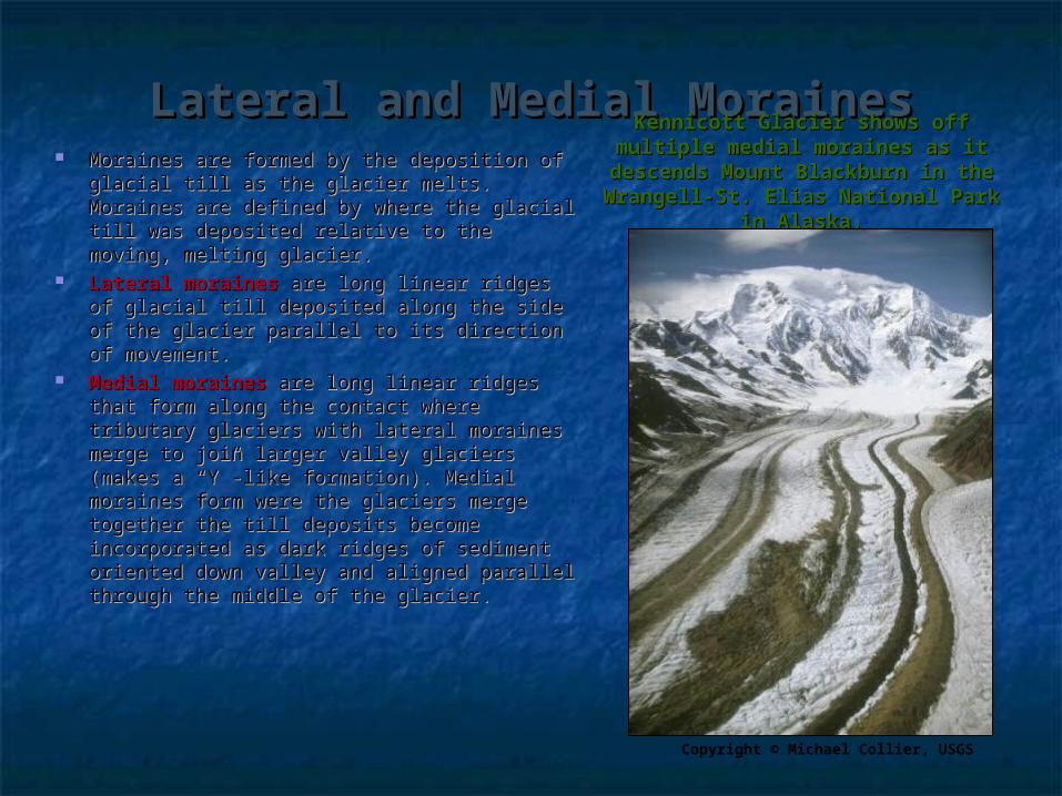
Lateral and Medial MorainesLateral and Medial Moraines Moraines are formed by the deposition of Moraines are formed by the deposition of
glacial till as the glacier melts. Moraines are glacial till as the glacier melts. Moraines are defined by where the glacial till was defined by where the glacial till was deposited relative to the moving, melting deposited relative to the moving, melting glacier.glacier.
Lateral moraines Lateral moraines are long linear ridges of are long linear ridges of glacial till deposited along the side of the glacial till deposited along the side of the glacier parallel to its direction of movement. glacier parallel to its direction of movement.
Medial moraines Medial moraines are long linear ridges are long linear ridges that form along the contact where tributary that form along the contact where tributary glaciers with lateral moraines merge to join glaciers with lateral moraines merge to join larger valley glaciers (makes a “Y”-like larger valley glaciers (makes a “Y”-like formation). Medial moraines form were the formation). Medial moraines form were the glaciers merge together the till deposits glaciers merge together the till deposits become incorporated as dark ridges of become incorporated as dark ridges of sediment oriented down valley and aligned sediment oriented down valley and aligned parallel through the middle of the glacier. parallel through the middle of the glacier.
Kennicott Glacier shows off Kennicott Glacier shows off multiple medial moraines as it multiple medial moraines as it
descends Mount Blackburn in the descends Mount Blackburn in the Wrangell-St. Elias National Park in Wrangell-St. Elias National Park in
Alaska.Alaska.
Copyright © Michael Collier, USGS