land value modeling and evaluation in the … · land value modeling and evaluation in the greater...
TRANSCRIPT

Bambang Edhi Leksono, Yuliana Susilowati, Sudarman, Andrayani
Land Value Modeling And Evaluation In The Greater Of Jakarta Area (7029)
FIG Congress 2014
Engaging the Challenges, Enhancing the Relevance
Kuala Lumpur, Malaysia, 16 – 21 June 2014
1/17
LAND VALUE MODELING AND EVALUATION IN THE GREATER
OF JAKARTA AREA
Bambang Edhi LEKSONO, Yuliana SUSILOWATI, SUDARMAN, ANDRAYANI,
Indonesia
Key words: Land Valuation, Multiple Regression, Jabodetabek, Greater Jakarta
SUMMARY
The Greater of Jakarta is the urban agglomeration surrounding of the Jakarta as a capital city,
in Indonesia. The area comprises the DKI Jakarta and parts of West Java and Banten
provinces, specifically the three Regencies of those provinces which surround Jakarta - Bekasi
and Bogor in West Java, and Tangerang in Banten. Also included were the Kota (formerly
Kotamadya) independent municipalities of Bogor, Depok, Bekasi, Tangerang and South
Tangerang. The name of the region is taken from the first two (or three) letters of each city's
name: Jabo(de)tabek from Jakarta, Bogor, (Depok), Tangerang and Bekasi. The Valuation
of land in this area is an attempt to realize equity in the tax system and the legal aspect of
land tenure, as well as the stream direction of optimum land use (highest and best use). Land
value data transaction reports from some official land agencies such as PPAT in Indonesia
have also proven to be inaccurate in its valuation’s manner . Some research of Wibowo, et al
(2009) indicated a link between population density per unit area of the village, the population
density per built up area of the village, the percentage of built up area every village, and
distance of villages to the CBD (Central Business District) of DKI Jakarta to land values
within the greater Jakarta. This research aims to produce land value model and the evaluation
of land value based on the characteristics of these four variables. The analytical method used
in this study is multiple regression analysis with dependent variable Y = Value of Land, as
well as the independent variable X1 = population density per unit area of the village
Jabodetabek, X2 = density of population per built up area the village, X3 = percentage of the
built up area each village, and X4 = distance of the village to the CBD (Central Business
District) of DKI Jakarta. Conclusion of this research is the X1 (population density per unit
area of the village) is proportional to the value of land in Bodetabek, but inversely
proportional to the value of land in the area of DKI Jakarta, X2 (density of population per built
up area of the village) did not affect value of land in the Jabodetabek area, X3 (percentage
built up area each village) is directly proportional to land value only in areas Bodetabek, and
X4 (distance of each villages to the CBD DKI Jakarta) is inversely proportional to the value of
land in the Jabodetabek area.
SUMMARY (optional summary in Bahasa Indonesia)

Bambang Edhi Leksono, Yuliana Susilowati, Sudarman, Andrayani
Land Value Modeling And Evaluation In The Greater Of Jakarta Area (7029)
FIG Congress 2014
Engaging the Challenges, Enhancing the Relevance
Kuala Lumpur, Malaysia, 16 – 21 June 2014
2/17
Greater Jakarta adalah Aglomerasi perkotaan seputar Jakarta sebagai ibu kota, di Indonesia.
Daerah ini terdiri dari DKI Jakarta dan bagian-bagian dari Provinsi Jawa Barat dan Banten,
khususnya tiga kabupaten di provinsi yang mengelilingi Jakarta - Bekasi dan Bogor Jawa
Barat, dan Tangerang di Banten. Termasuk juga beberapa kotamadya yang independen seperti
Bogor, Depok, Bekasi, Tangerang, dan Tangerang Selatan. Nama daerah ini diambil dari
huruf pertama dua (atau tiga) dari masing-masing kota nama: Jabo (de) tabek dari Jakarta,
Bogor, (Depok), Tangerang dan Bekasi. Penilaian tanah merupakan upaya dalam
mewujudkan keadilan (equity) dalam sistem perpajakan dan legalisasi penguasaan tanah, serta
pengarahan pemanfaatan tanah yang optimal (penggunaan tertinggi dan terbaik). Data laporan
transaksi nilai tanah dari lembaga resmi seperti PPAT di Indonesia juga terbukti tidak akurat
(Rachman : 2006). Wibowo dkk (2009) mengindikasikan adanya kaitan antara kepadatan
penduduk per luas desa/kelurahan, kepadatan penduduk per area terbangun desa/kelurahan,
persentase area terbangun tiap desa/kelurahan, dan jarak desa/kelurahan tersebut ke CBD
(Central Business District) DKI Jakarta terhadap nilai tanah di wilayah Jabodetabek.
Penelitian ini bertujuan menghasilkan model nilai tanah berdasarkan karakteristik keempat
variabel tersebut. Metode analisis yang digunakan dalam penelitian ini adalah metode regresi
berganda dengan variabel terikat Y =Nilai Tanah, serta variabel bebas X1 = kepadatan
penduduk per luas desa/kelurahan wilayah Jabodetabek, X2 = kepadatan penduduk per area
terbangun desa/kelurahan, X3 = persentase area terbangun tiap desa/kelurahan, dan X4 = jarak
desa/kelurahan tersebut ke CBD (Central Business District) DKI Jakarta. Kesimpulan yang
diperoleh dari penelitian ini adalah X1 (kepadatan penduduk per luas desa/kelurahan)
berbanding lurus dengan nilai tanah di Bodetabek, namun berbanding terbalik dengan nilai
tanah di wilayah DKI Jakarta, X2 (kepadatan penduduk per area terbangun desa/kelurahan)
tidak berpengaruh terhadap nilai tanah di wilayah Jabodetabek, X3(persentase area terbangun
tiap desa/kelurahan) berbanding lurus dengan nilai tanah hanya di wilayah Bodetabek, dan X4
(jarak desa/kelurahan tersebut ke CBD DKI Jakarta) berbanding terbalik dengan nilai tanah di
wilayah Jabodetabek.

Bambang Edhi Leksono, Yuliana Susilowati, Sudarman, Andrayani
Land Value Modeling And Evaluation In The Greater Of Jakarta Area (7029)
FIG Congress 2014
Engaging the Challenges, Enhancing the Relevance
Kuala Lumpur, Malaysia, 16 – 21 June 2014
3/17
LAND VALUE MODELING AND EVALUATION IN THE GREATER
OF JAKARTA AREA
Bambang Edhi LEKSONO, Yuliana SUSILOWATI, SUDARMAN, ANDRAYANI,
Indonesia
1. INTRODUCTION
Background Land valuation is required in order to bring equity in the tax system and the legalization of
land tenure, as well as the direction of optimum land use (highest and best use). Land value
data transaction reports from official agencies such as PPAT also prove to be inaccurate
(Rachman: 2006).
Republic of Indonesia National Land Agency (BPN) according to the mandate of Article
33 paragraph (3) of Law No. 5 Year 1960 as an institution mandated by regulation carry
relations with the land and people of Indonesia in its efforts to be more involved in all aspects
relating to the land, including the the land valuation is based on Regulation of the Republic of
Indonesia Number 10 Year 2006 concerning the National Land Agency to develop and
manage organizational units returned with the release of the National Land Agency Head of
National Land Agency Regulation No. 3 Year 2006 regarding Organization and Working
Procedure of the National Land Agency of the Republic of Indonesia where the task set
formulation of technical policy and to implement the survey and mapping of potential land
(including on valuation of land) is the core duties for the Directorate of Land Potential
Surveys. The value of land used in the valuation of land by the BPN is the market value.
However, due to organizational units about valuating this land is still relatively new in the
BPN, the provision of information on land value is still limited. For areas that are not yet
available information on land value created by the BPN, NJOP data can be used.
The development value of land alone can not be separated from the development progress.
Society tends to cluster in areas that are considered able to meet the needs of its survival.
Grouping in the built up area is causing land values (due to the gap of supply and demand)
increased. One of the real phenomenon is visible is the spread of the built up area in the area
around DKI Jakarta. Research conducted by the Research Center for Limnology LIPI Bogor
(Wibowo et al, 2009) in the Jabodetabek area indicated a correlation between the
development of the built up area to the value of the land. DKI Jakarta, which grew into the
center of activities make this city as a provider of jobs, but the land for the settlements are no
longer affordable for workers, so that newly developed settlements in the suburbs like in
Bekasi, Bogor and Tangerang. In accordance with the principles of an economic price if the
item required is still quite available, the price established by the market mechanism would not
be as high if the required items are not sufficiently available. So also with land in the area of
Bogor, Depok, Tangerang and Bekasi (Bodetabek) which is still fairly widely available, is the
option most suitable place for living for workers in the economy which is based in Jakarta.
Fulfilling the need for settlement in line with population growth from an area of land
conversion trigger has not been built into the area awakened. However, land to build
settlements are no longer affordable for workers, so that newly developed built up area in
Bodetabek. This certainly will impact on the value of land in the Jabodetabek area (Jakarta,

Bambang Edhi Leksono, Yuliana Susilowati, Sudarman, Andrayani
Land Value Modeling And Evaluation In The Greater Of Jakarta Area (7029)
FIG Congress 2014
Engaging the Challenges, Enhancing the Relevance
Kuala Lumpur, Malaysia, 16 – 21 June 2014
4/17
Depok, Bogor, Tangerang, Bekasi). This study uses the Tax Object Sale Value (NJOP)
average each village as the reference value of the land. Pattern of land value in the
Jabodetabek area (Jakarta, Bogor, Depok, Tangerang, and Bekasi) as a large area can be
traced back further, based on data obtained in this study.
Problem Formulation
Problem formulation in this study is how population density per unit area of the village,
the population density per built up area the village, the percentage of the built up area every
village, and distance of each village to explain the Jakarta CBD land values model in
Jabodetabek area.
The purpose of this study is to examine the characteristics of the population density per
unit area of the village, the population density per built up area the village, the percentage of
the built up area every village, and distance of each village to the CBD of Jakarta to the value
of land in the Jabodetabek area.
The purpose of this research is to produce a model of land value in the Jabodetabek area
based on characteristics of population density per unit area of the village, the population
density per built up area the village, the percentage of the built up area every village, and
distance of each village to the CBD of Jakarta.
The hypothesis of this study is the population density per unit area of the village, the
population density per built up area the village, the percentage of the built up area every
village, and distance of each village to the Jakarta CBD effect the value of land in the
Jabodetabek area.
The benefits of this research is the model of land value generated in this study can be
applied to the development of the land value model is more accurate, especially in the
Jabodetabek area.
Type text here …
2. LITERATURE REVIEW
2.1 Previously Research
Various research on the development of methods of land valuation has been done by some
researchers. Among the research conducted Imawan (2007), who conducted the land
valuation method development use spatial analysis and artificial neural network. Location
variables are used as the main variables in the model of land value considering that the
variable location is a very significant variable in the model of land value.
Rachman (2006) use a deterministic regression equation for predicting the NIR (Y) based
on PPAT deed report (X). Based on this research indicates that PPAT transaction price
averaged only 56% of the NIR PBB.
Research conducted Wibowo et al (2009) showed that there are indications that the
distribution of population and the increasing need for housing that increases the built up
area in the Jabodetabek area related to land value, for it was based on secondary data from
these studies established the independent variable is the population density per unit area of
the village , density of population per built up area the village, and the percentage built up
area area of each rural village.
2.2 Land Valuation Method
Broadly speaking, land valuation methods commonly used method of market data

Bambang Edhi Leksono, Yuliana Susilowati, Sudarman, Andrayani
Land Value Modeling And Evaluation In The Greater Of Jakarta Area (7029)
FIG Congress 2014
Engaging the Challenges, Enhancing the Relevance
Kuala Lumpur, Malaysia, 16 – 21 June 2014
5/17
approach, cost approach and income approach.
1. Market Data Approach.
This approach is considering sales of similar property or replacement and related market
data, and generate the estimated value through the process (object valuation) compared
with transactions of comparable properties, whether the property has occurred or is still in
the bidding phase of a sales process.
2. Cost Approach.
This approach considers the possibility that, as the substitution of purchasing a property, a
person can make other property such as a replica of the original property or substitutes
that provide comparable functionality.
3. Income Approach
This approach considers the income and expenses associated with property valued and to
estimate the value through the capitalization process. Capitalization linking income
(usually a net income) with a definition of value through conversion of income into value
estimation.
2.3 Regression Analysis
The analysis used in this study are multiple regression (Multiple Regression Analysis).
Multiple regression analysis is a statistical tool that provides an explanation of the pattern
of relationships (models) between the dependent variable with independent variables wich
is more than one (Widarjono, 2005), in order to obtain the equation:
Y = C + + b3X3 b2X2 b1X1 + + b4X4 + Et
where:
Y
C
X1
X2
X3
X4
bn
Et
=
=
=
=
=
=
=
=
Dependent variable, in this case the
value
land (Rupiah/m2)
Constant
Variable population density per
unit area
villages (Person / Ha)
Variable population density per
built up area each village (Person /
Ha)
Variable percentage of the built up
area
to area villages
Variable Distance to CBD Jakarta
(km)
Independent variable coefficients
Error term
Furthermore, the resulting multiple regression equation must be through statistical tests
and classical assumption. Test statistics and classical assumption in this research was done
by using statistical software SPSS 17.00.
Bambang Edhi Leksono, Yuliana Susilowati, Sudarman, Andrayani
Land Value Modeling And Evaluation In The Greater Of Jakarta Area (7029)
FIG Congress 2014
Engaging the Challenges, Enhancing the Relevance
Kuala Lumpur, Malaysia, 16 – 21 June 2014
6/17
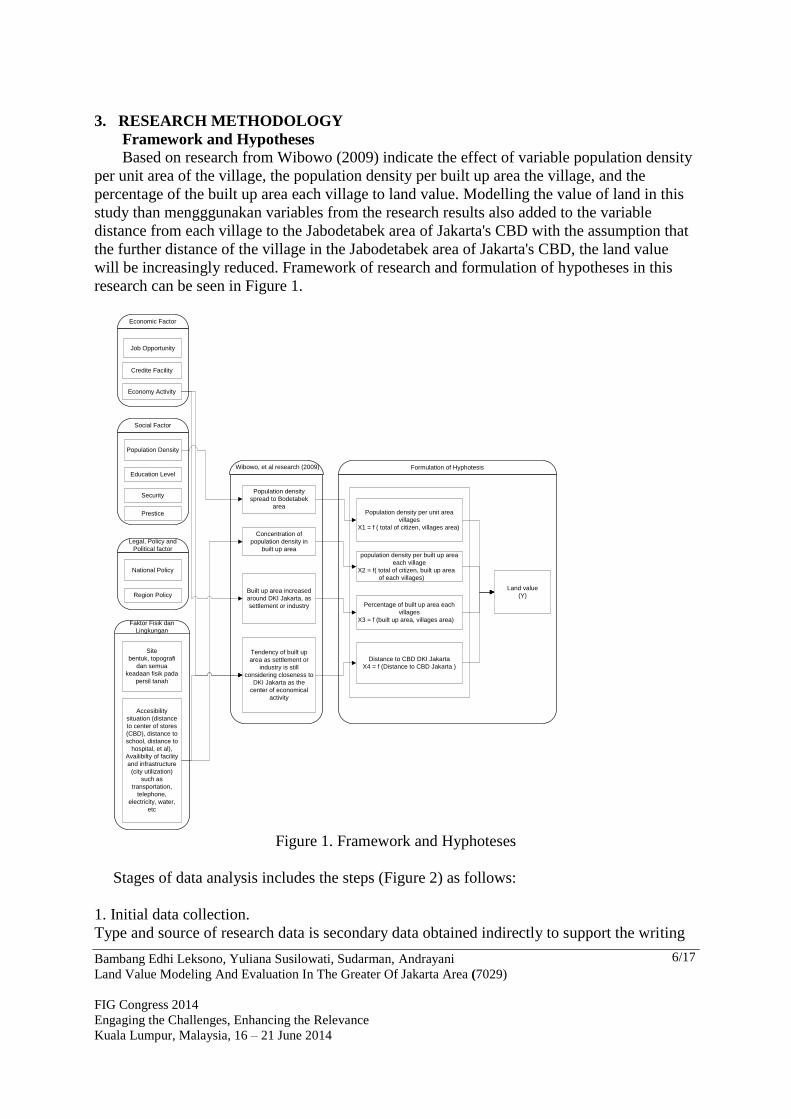
3. RESEARCH METHODOLOGY
Framework and Hypotheses
Based on research from Wibowo (2009) indicate the effect of variable population density
per unit area of the village, the population density per built up area the village, and the
percentage of the built up area each village to land value. Modelling the value of land in this
study than mengggunakan variables from the research results also added to the variable
distance from each village to the Jabodetabek area of Jakarta's CBD with the assumption that
the further distance of the village in the Jabodetabek area of Jakarta's CBD, the land value
will be increasingly reduced. Framework of research and formulation of hypotheses in this
research can be seen in Figure 1.
Economic Factor
Job Opportunity
Credite Facility
Economy Activity
Social Factor
Population Density
Education Level
Security
Prestice
Legal, Policy and
Political factor
National Policy
Region Policy
Faktor Fisik dan
Lingkungan
Site
bentuk, topografi
dan semua
keadaan fisik pada
persil tanah
Accesibility
situation (distance
to center of stores
(CBD), distance to
school, distance to
hospital, et al),
Availibilty of facility
and infrastructure
(city utilization)
such as
transportation,
telephone,
electricity, water,
etc
Population density per unit area
villages
X1 = f ( total of citizen, villages area)
population density per built up area
each village
X2 = f( total of citizen, built up area
of each villages)
Percentage of built up area each
villages
X3 = f (built up area, villages area)
Distance to CBD DKI Jakarta
X4 = f (Distance to CBD Jakarta )
Wibowo, et al research (2009)
Population density
spread to Bodetabek
area
Concentration of
population density in
built up area
Built up area increased
around DKI Jakarta, as
settlement or industry
Tendency of built up
area as settlement or
industry is still
considering closeness to
DKI Jakarta as the
center of economical
activity
Formulation of Hyphotesis
Land value
(Y)
Figure 1. Framework and Hyphoteses
Stages of data analysis includes the steps (Figure 2) as follows:
1. Initial data collection.
Type and source of research data is secondary data obtained indirectly to support the writing

Bambang Edhi Leksono, Yuliana Susilowati, Sudarman, Andrayani
Land Value Modeling And Evaluation In The Greater Of Jakarta Area (7029)
FIG Congress 2014
Engaging the Challenges, Enhancing the Relevance
Kuala Lumpur, Malaysia, 16 – 21 June 2014
7/17
of this research is to collect supporting data obtained from the Limnology Research Centre
LIPI Bogor Cibinong and from other relevant agencies as well as with library research,
internet, and interviews .
2. Data extraction.
Secondary data have been obtained subsequently extracted to obtain data on variables -
variables that will be used in modeling.
3. The selection and grouping (classification) of land value.
Selection of land value data used from the total number of villages of 1484, land value data
can be obtained from the 1436 data of land value village. Furthermore, this value data were
analyzed using the data distribution histogram and boxplot to determine their distribution
patterns. Based on the analysis results obtained by the histogram and boxplot are several
groups of land value data. Each group then separated the land value data as the data model
and test data.
4. Development of mathematical models
Land value model used in this study is the land value model with multiple regression analysis.
Each group of land value data were then analyzed with multiple regression.
5. Mathematical Model Selection and Testing
The mathematical model selected is the equation that satisfy the statistical test (the value of R,
R2, and Sig Sig Simultaneous Partial) and economic test (multicollinearity).
6. Mathematical Model Validation
The mathematical model applied to the next selected test data, and then searched the excess
land value land value of the model with field test data and analyzed with a histogram. If based
on election results and the test model obtained satisfactory results (difference in value of the
model results and field values is not large), we then applied to all data on land value data
group.
7. Application of Mathematical Model
The mathematical model is then applied to all data on land value data group.

Bambang Edhi Leksono, Yuliana Susilowati, Sudarman, Andrayani
Land Value Modeling And Evaluation In The Greater Of Jakarta Area (7029)
FIG Congress 2014
Engaging the Challenges, Enhancing the Relevance
Kuala Lumpur, Malaysia, 16 – 21 June 2014
8/17
Collecting Data
Selecting and Testing
Mathematicals Models
Validation of selected
Mathematicals Models
YesNo
Selecting and Clasification Land
Value Data
Data Extraction
Developing Mathematichal Models
Analysis Results of Applying
Mathematicals Models
Applying Mathematicals
Models
Figure 2: Stages of data analysis
4. RESULTS AND DISCUSSION

Bambang Edhi Leksono, Yuliana Susilowati, Sudarman, Andrayani
Land Value Modeling And Evaluation In The Greater Of Jakarta Area (7029)
FIG Congress 2014
Engaging the Challenges, Enhancing the Relevance
Kuala Lumpur, Malaysia, 16 – 21 June 2014
9/17
4.1 Overview Research Areas
Figure 3: Areaal administration Jabodetabek
Jabodetabek is an acronym of DKI Jakarta (except the Thousand Islands), Bogor District,
Bogor City, Depok City, Tangerang District, Tangerang City, South Tangerang City, Bekasi
City and Bekasi District. Jabodetabek area is located at coordinates 106 ° 20'-107 ° 27'29
"east longitude and 6 ° 00'-sixth ° 45 'latitude North South.Wilayah Jabodetabek bordering the
Java Sea, south by the district of Sukabumi, west side adjacent to the city of Serang, and the
east by the Karawang area.
4.2 Data Input and Data Extraction
Data input and extraction of data processing results of spatial analysis can be found in
Appendix 1 and 2.
4.3 Selecting and Grouping Land Value Data
Land Value Data The next stage is selecting land value data by analyzing distribution of the data by using a
histogram and boxplot.

Bambang Edhi Leksono, Yuliana Susilowati, Sudarman, Andrayani
Land Value Modeling And Evaluation In The Greater Of Jakarta Area (7029)
FIG Congress 2014
Engaging the Challenges, Enhancing the Relevance
Kuala Lumpur, Malaysia, 16 – 21 June 2014
10/17
Figure 3. Histogram of Jabodetabek Land Value
Figure 4. Boxplot of Jabodetabek Land Value
Based on the results of histogram analysis and classification of land value data obtained 3
(three) groups of the distribution of land values, namely:
1. Group of land value data less than Rp.2.309.500, -/m2.
2. Group of land value data between Rp.2.309.500, -/m2 s / d Rp. 9,000,000 -/m2
3. Group land value data more than Rp. 9,000,000 -/m2.
However, based on the results of the development and application of the model, land value of
the Jabodetabek area can be divided into 3 (three) groups, which is :
1. Group of land value data less than Rp.2.309.500, -/m2 in Bodetabek area
2. Group of land value data less than Rp.9.000.000/m2 in DKI Jakarta area
Bambang Edhi Leksono, Yuliana Susilowati, Sudarman, Andrayani
Land Value Modeling And Evaluation In The Greater Of Jakarta Area (7029)
FIG Congress 2014
Engaging the Challenges, Enhancing the Relevance
Kuala Lumpur, Malaysia, 16 – 21 June 2014
11/17
3. Group of land value data more than Rp.9.000.000, - /m2 in DKI Jakarta area
Recapitulation of the selection equation of group of land value data can be found in
Appendix 3.
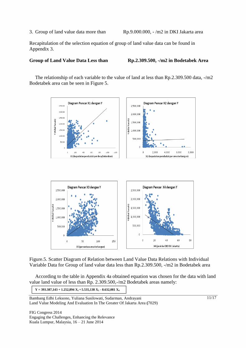
Group of Land Value Data Less than Rp.2.309.500, -/m2 in Bodetabek Area
The relationship of each variable to the value of land at less than Rp.2.309.500 data, -/m2
Bodetabek area can be seen in Figure 5.
Figure.5. Scatter Diagram of Relation between Land Value Data Relations with Individual
Variable Data for Group of land value data less than Rp.2.309.500, -/m2 in Bodetabek area
According to the table in Appendix 4a obtained equation was chosen for the data with land
value land value of less than Rp. 2.309.500,-/m2 Bodetabek areas namely:
Y = 393.387,143 + 1.252,894 X1 + 5.535,138 X3 - 8.632,081 X4

Bambang Edhi Leksono, Yuliana Susilowati, Sudarman, Andrayani
Land Value Modeling And Evaluation In The Greater Of Jakarta Area (7029)
FIG Congress 2014
Engaging the Challenges, Enhancing the Relevance
Kuala Lumpur, Malaysia, 16 – 21 June 2014
12/17
X1 and X4 have significant correlation with the value of land with a strong enough that the
R value of 0.702. Adjusted R2 value of 0,491 means that the independent variables in this case
X1 (population density per unit area of the village) and X4 (distance to the CBD DKI Jakarta)
jointly explain the variable land value only amounted for 49,1%, while the remaining 50, 9%
is explained by other variables not examined in this study. This may imply that in fact the
land value data group is the only variable X1 (population density per unit area of the village)
and X4 that affect land values. The equation is then applied to all data. Validation and
application of the model on test data and field data on land value data group can be found in
Appendix 5a.
Distribution maps of the difference in value of land application of the results of this model
can be seen in Appendix 6a which shows that:
1. Under estimate spread along the road network (arterial roads, highways and railways) and
areal around center of Bogor City.
2. Most of the difference error is over estimate less than Rp.500,000, -.
3. The highest over estimate (more than 500,000,-) is in the area of Bekasi.
4. There are still negative results for the area with a distance more than 50 km from the center
of DKI Jakarta's CBD.
Group of land value data less than Rp.9.000.000/m2 in DKI Jakarta areaThe
relationship of each variable on land value land value data on less than Rp.9.000.000, -/m2 in
Jakarta area can be seen in Figure 6.
Figure 6. Scatter Diagram of Relation between Land Value Data Relations with Individual
Variable Data for Group of Land Value Data less than Rp.9.000.000, -/m2 in DKI Jakarta
Area
According to the table in Appendix 4b obtained equation to the data selected land value
land value is less than Rp.9.000.000/m2 in Jakarta area, namely:
Y = 8.025.301,689 – 2.664,118 X1 - 399,283.318 X4
Bambang Edhi Leksono, Yuliana Susilowati, Sudarman, Andrayani
Land Value Modeling And Evaluation In The Greater Of Jakarta Area (7029)
FIG Congress 2014
Engaging the Challenges, Enhancing the Relevance
Kuala Lumpur, Malaysia, 16 – 21 June 2014
13/17
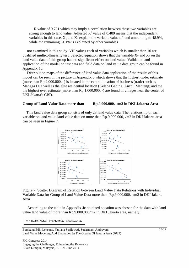
R value of 0.701 which may imply a correlation between these two variables are
strong enough to land value. Adjusted R2 value of 0.489 means that the independent
variables in this case, X1 and X4 explain the variable value of land amounting to 48.9%,
while the remaining 51.1% is explained by other variables
not examined in this study. VIF values each of variables which is smaller than 10 are
qualified multicollinearity test. Selected equation shows that the variable X2 and X3 on the
land value data of this group had no significant effect on land value. Validation and
application of the model on test data and field data on land value data group can be found in
Appendix 5b.
Distribution maps of the difference of land value data application of the results of this
model can be seen in the picture in Appendix 6 which shows that the highest under estimate
(more than Rp.2.000.000, -) is located in the central location of business (trade) such as
Mangga Dua well as the elite residential location (Kelapa Gading, Ancol, Menteng) and the
the highest over estimate (more than Rp.1.000.000, -) are found in villages near the center of
DKI Jakarta's CBD.
Group of Land Value Data more than Rp.9.000.000, -/m2 in DKI Jakarta Area
This land value data group consists of only 23 land value data. The relationship of each
variable on land value land value data on more than Rp.9.000.000,-/m2 in DKI Jakarta area
can be seen in Figure 7.
Figure 7: Scatter Diagram of Relation between Land Value Data Relations with Individual
Variable Data for Group of Land Value Data more than Rp.9.000.000, -/m2 in DKI Jakarta
Area
According to the table in Appendix 4c obtained equation was chosen for the data with land
value land value of more than Rp.9.000.000/m2 in DKI Jakarta area, namely:
Y = 16.760.173,473 – 17.571,799 X1 - 616.217,677 X4

Bambang Edhi Leksono, Yuliana Susilowati, Sudarman, Andrayani
Land Value Modeling And Evaluation In The Greater Of Jakarta Area (7029)
FIG Congress 2014
Engaging the Challenges, Enhancing the Relevance
Kuala Lumpur, Malaysia, 16 – 21 June 2014
14/17
X1 and X4 which correlate quite strongly with land values with the R value of 0.761.
Adjusted R2 value of 0.536 means that the independent variables in this case X1 (population
density per unit area of the village) and X4 (distance to the CBD DKI Jakarta) jointly explain
the variable value of land registration by 53.6%, while the remaining 46, 4% is explained by
other variables not examined in this study. This means that in fact the land value data group is
the only variable X1 (population density per unit area of the village) and X4 that affect land
values. The equation is then applied to all data (Annex 5c).
Land value data on this group as well as a test data so that the results of the above equation
can be further illustrated in Figure in the Appendix which shows that:
1. The highest under estimate (more than Rp1, 000,000, -) is in this group is located in the
central location of business (trade), namely in the area Setia Budi, South Jakarta district.
2. The highest over estimate (more than Rp.2.000.000,-) is in North Petojo district
(Kecamatan Gambir) and Kampung Bali (Tanah Abang District) which is a densely
populated slum.
5. CONCLUSIONS AND RECOMMENDATIONS
5.1 Conclusion:
Based on the results of research on the conclusion drawn is:
• The value of land in the Jabodetabek area is the highest land value in the center of Jakarta
CBD.
• Model the value of land in the Jabodetabek area is divided in 3 (three) groups of land value
data, namely:
1. Group of land value data less than Rp.2.309.500, -/m2 in Bodetabek area
Y = 393.387,143 + 1.252,894 X1 + 5.535,138 X3 – 8.632,081 X4
2. Group of land value data less than Rp.9.000.000/m2 in DKI Jakarta area
Y = 8.025.301,689 – 2.664,118 X1 - 399,283.318 X4
3. Group of land value data more than Rp.9.000.000, - /m2 in DKI Jakarta area
Y = 16.760.173,473 – 17.571,799 X1 – 616.217,677 X4
• From the analysis above conclusions have been associated with the effect of each variable
to the value of the land, among others:
1. X1 variables (population density per unit area of the village) influence land value in the
Jabodetabek area. This variable is directly proportional to the value of land in the area
Bodetabek, but inversely proportional to the value of land in Jakarta area. This is more
due to the function of areas of Jakarta as a center of business and government.
2. X2 variables (population density per built up area each village) did not affect land values
in all groups of land value data in the Jabodetabek area.
3. X3 variables only affect the data value of land in Bodetabek area. This variable is
directly proportional to the value of land in the territory Bodetabek. This could mean
that the percentage of built up area in Bidetabek is smaller compared to Jakarta area so
that can still allowing movement of population movement into Bodetabek area.
4. X4 (distance to the center of DKI Jakarta’s CBD) effect on land values in all groups of
land value data in the Jabodetabek area. This variable is inversely proportional to the
value of land in the Jabodetabek area, This can be interpreted as the accessibility to the
center of Jakarta CBD is very influential on the value of land in the Jabodetabek area.

Bambang Edhi Leksono, Yuliana Susilowati, Sudarman, Andrayani
Land Value Modeling And Evaluation In The Greater Of Jakarta Area (7029)
FIG Congress 2014
Engaging the Challenges, Enhancing the Relevance
Kuala Lumpur, Malaysia, 16 – 21 June 2014
15/17
• The highest under estimate in the Bodetabek area is around the facility of a road to Jakarta
and surrounding areas close to areas of Jakarta, while at the Jakarta area under estimate as
there are differences in the area that functioned as business centers and elite residential
location.
• Over estimate (model results are higher than the ground field) in the Bodetabek area is in
areas far from the center of Jakarta's CBD, but the over estimate on Bodetabek area are
generally not too large (less than 500,000, -/m2) . Differences over estimate the highest in
the Jakarta area (more than Rp1.000.000, -/m2) contained in the areas adjacent to the
center of Jakarta's CBD, but with high population density.
5.2 Recommendations
Based on these results, the distance to the CBD of DKI Jakarta is the distance that
most influence on land values, but there are differences under the model estimate land
value when approaching the center of CBD in other areas. For further research is
needed to consider in addition to the Jakarta CBD is also the influence of accessibility
to Karawaci (Tangerang) and Cikarang (Bekasi).
The model generated in this study can be applied to the valuation of land in the BPN
using the market value.
Linear regression method was used in this study need to be developed on a different
approach methods, especially nonlinear model approach
6. ACKNOWLEDGEMENTS
Praise and gratitude to Allah SWT with His blessing and mercy. Authors are also grateful
to Mr. Ir.Didik Wihardi, MS and Mrs.Dr.Ir.Yuliana Susilowati,M.Si as an mentor, Drs.
Wahyono Ary, M.Si as a reviewer and Mr Hendro Wibowo, S. Si, M. Si, Mr Ir.Eko
Harsono, MT and Mr. Fajar Setiawan, S. with all members of LIPI competitive team for
ideas, suggestions and data have been provided
7. REFERENCES
Anonim, Sejarah JAKARTA Riwayat Sebuah Kota,
http://swaramuslim.net/galery/more.php?id=A5617_0_18_0_M
Imawan, Diddy Wahyudi, (2007), Pengembangan Metoda Penilaian Tanah dengan
menggunakan Analisis Spasial dan Jaringan Syaraf Tiruan, Tesis S2, Pasca Sarjana, ITB,
Bandung.
Gujarati, Damodar, (1978), Ekonometrika Dasar, Erlangga, Jakarta
Mauludin, Hanif, (2002), Perbincangan Seputar Pengolahan Data Penelitian, Manajemen
Keuangan, STIEMARA.
Rachman, Arif, (2006), Model Prediktor NIR (Nilai Indikasi Rata-Rata) berdasarkan
Laporan Bulanan Notaris PPAT, Tesis S2, Pasca Sarjana, ITB, Bandung.
Bambang Edhi Leksono, Yuliana Susilowati, Sudarman, Andrayani
Land Value Modeling And Evaluation In The Greater Of Jakarta Area (7029)
FIG Congress 2014
Engaging the Challenges, Enhancing the Relevance
Kuala Lumpur, Malaysia, 16 – 21 June 2014
16/17
Sadyohutomo, Mulyono, (2008), Manajemen Kota dan Wilayah, Realita dan Tantangan,
Bumi Aksara, Bandung.
Santoso, Singgih, (2004), Riset Pemasaran, Konsep dan Aplikasi dengan SPSS,
Elexmedia Komputindo, Kelompok Gramedia, Jakarta.
Setyadharma, Andryan (2010), Uji Asumsi Klasik dengan SPSS 16.0, Fakultas Ekonomi,
Universitas Negeri Semarang. http://akuntansi.unnes.ac.id/wp-
content/uploads/2010/05/Uji-Asumsi-Klasik-dengan-SPSS-16.0.pdf (diunduh tanggal 24
Mei 2010).
Suselo, Hendropranoto (2000), Jabodetabek dan Turunannya Sepanjang Sejarah,
Penataan Ruang dan Pembangunan Perkotaan
Sudjana, (2005), Metoda Statistika, Tarsito, Bandung.
Suharno, (2003), Pajak Properti di Indonesia Kajian Teoritis dan Empiris, Direktorat
PBB dan BPHTB, Jakarta
Soeparjanto (2008), Modul Konsep Dasar Penilaian Tanah, Pusat Pendidikan dan
Pelatihan Departemen Keuangan, Jakarta
Wibowo, Hendro, dkk (2009), Optimasi Penataan Ruang Untuk Menjamin Ketersediaan
dan Kelestarian Sumber Daya Air Wilayah Jabodetabek, Laporan Akhir Tahun 2009
Kegiatan Program Kompetitif Lembaga Ilmu Pengetahuan Indonesia.
Wahana Komputer, (2009), SPSS 17 untuk Pengolahan Data Statistik, , C.V. Andi Offset,
Jakarta.
BIOGRAPHICAL NOTES
Bambang Edhi Leksono, Yuliana Susilowati, Sudarman, Andrayani
Land Value Modeling And Evaluation In The Greater Of Jakarta Area (7029)
FIG Congress 2014
Engaging the Challenges, Enhancing the Relevance
Kuala Lumpur, Malaysia, 16 – 21 June 2014
17/17
Dr. Bambang Edhi Leksono Graduate Program for Land Administration
Bandung Institute of Technology, ,
Labtek IX-C 3rd floor, Jl Ganesha 10,
Bandung- 40132, INDONESIA
Tel. +62.22.2530701
Fax. +62.22.2530702
Email: [email protected]
ANDRAYANI, M.Sc.
Master student in Graduate Program for Land
Administration, Bandung Institute of
Technology, , Labtek IX-C 3rd floor, Jl
Ganesha 10, Bandung-40132,
INDONESIA.
Tel. +62.22.2530701
Fax.+62.22.2530702
Email: [email protected]
SUDARMAN, M.Sc.
Graduate Program for Land Administration
Bandung Institute of Technology, ,
Labtek IX-C 3rd floor, Jl Ganesha 10,
Bandung- 40132, INDONESIA
Tel. +62.22.2530701
Fax.+62.22.2530702
Email: [email protected]
Dr. Yuliana Susilowati
Research Centre for Geotechnology,
Indonesian Institute of Science, Building-70,
Jl.Sangkuriang, Bandung, INDONESIA.
Tel. +62 22 2503654
Fax + 62 22 2503597
Email: [email protected]
CONTACTS
Dr. Bambang Edhi LEKSONO
Graduate program in Land Administration,
Faculty of Earth Sciences and Technology,
Institute of Technology Bandung,
Labtek IX-C Building 3rdFloor,
Jl. Ganesha 10,
Bandung-40293
INDONESIA
Tel. +62.22.2530701
Fax + 62.22.2530702
Email: : [email protected] and [email protected]
Web site: