land evaluation for sustainable land...
TRANSCRIPT

Land Evaluation for Sustainable Land Management
by
Klaas Jan Beek, Kees de Bie and Paul Driessen
Prof.Dr.Ir.K.J. Beek Professor in Land EvaluationIr.C.A. de Bie Tropical Agronomist; Agricultural, Conservation and Environment Division (ACE)Prof.Dr.Ir.P.M. Driessen Visiting Professor; Agricultural, Conservation and Environment Division (ACE)
International Institute for Aerospace Survey and Earth Sciences (ITC)P.O.Box 6, 7500 AA Enschede, The Netherlands
Land Evaluation for Sustainable Land Management Beek, de Bie, Driessen
2
Summary
Land evaluation assesses the suitability of land for specified land uses. A distinction ismade between qualitative evaluation, mainly based on expert judgment, and quantitativeevaluation, based on process simulation models. Land evaluation and quantitative landuse systems analysis support the planning of sustainable use of land. The FAOFramework for Land Evaluation (FAO 1976) provides guidance for land suitabilityassessment in developing countries where data scarcity often constrains modeling.Integration of bio-physical and socio-economic information and sustainable use of landresources are important principles. Several programming techniques are available tomatch the results of land evaluation with the available means of governments, land usersand other stakeholders, to achieve optimal land use.
The contribution that information technology can make to land evaluation and sustainableland management is discussed. As yet, infrastructural obstacles hinder the effective useof information technology, but it is expected that digital land resource databases andnetworked information processing will free specialist time for data analysis and modelingleading to management and decision support systems for sustainable land management,based on spatial information of soils and other land attributes.
1. Introduction to land evaluation
Land evaluation assesses the suitability of land for specified land uses. The FAO (1995)defined Land as:
A delineable area of the earth's terrestrial surface, encompassing all attributes ofthe biosphere immediately above or below this surface, including those of the near-surface climate, the soil and terrain forms, the surface hydrology (including shallowlakes, rivers, marshes, and swamps), near-surface sedimentary layers andassociated groundwater reserve, the plant and animal populations, the humansettlement pattern and physical results of past and present human activity(terracing, water storage or drainage structures, roads, buildings, etc.).
This definition encompasses at least eight functions of land that go beyond the productionof food:
• It is the basis of a variety of life support systems, through the production of food,fodder, fibre, fuel, timber and other biotic materials for human use, either directlyor through animal husbandry including aquaculture and inland and coastalfishery;
• Land is the basis of terrestrial bio-diversity by providing habitats and genereserves for plants, animals and micro-organisms, above and below ground;
• Land acts as a source and sink of greenhouse gases and is a co-determinant ofthe global energy balance (reflection, absorption and transformation of radiativeenergy of the sun);
• Land regulates the storage and flow of surface- and groundwater resources,and influences their quality;
• Land is a storehouse of raw materials and minerals;• Land retains, filters, buffers and transforms hazardous compounds;• Land provides the space for human settlements, industrial plants and social
activities such as sports and recreation, and connective space for transport ofpeople, inputs and produce, and for the movement of plants and animalsbetween natural ecosystems;
• Land stores and protects the evidence of the cultural history of mankind, and isa source of information on past climatic conditions and past land uses.
Land Evaluation for Sustainable Land Management Beek, de Bie, Driessen
3
Early civilizations took account of environmental conditions in their choice of settlementand in the development of their cultures. Subsequent breakdown of these civilizationsmay often be traced back to their degradation of the land resource base.
It is this risk of land degradation that stands at the root of land evaluation. Soil survey andland capability assessment gained impetus in the USA in the nineteen thirties in responseto severe soil erosion that threatened food production and the stability of society.Concerns about land degradation grew sharply, in part because of human and animalpopulation explosions in the developing world. Increasing population pressure oftencauses over-exploitation of high potential land and/or misuse of marginal land. The rate ofchange of pressure on land in critical regions will increasingly violate the limits of the land'scarrying capacity, even if available technological packages for managing the landresources have become better.A score of land evaluation concepts and analytical procedures have been developed sincethe nineteen thirties. They can be grouped in two broad categories: qualitative evaluationprocedures, based mainly on expert judgment; and quantitative evaluation methods, basedon process-oriented simulation models.
2. Land evaluation for land use planning
Most land evaluation is qualitative and based on expert judgment. The experts are mostlysoil surveyors and agronomists who interpret their field data to make them understandableto planners, engineers, extension officers and farmers. More recently, in-depth studies ofspecific soil-related constraints, in particular soil fertility, available water, available oxygen,soil workability and degradation hazards such as soil erosion and soil salinization have allfacilitated quantitative simulation of specific land use processes and opened the way foryield prediction. The development of information technology during the last twenty yearshas enabled researchers to make rapid progress in the analysis of interactions betweenland resources and land use and in quantitative land evaluation based on quantitativemodeling of land use systems.
However, placing land evaluation and land use systems analysis in the broader context ofland use planning, revealed a potential gap between technology-oriented land resourcespecialists, concerned with the present and future performance of the land resources, andhuman-oriented (social) scientists, concerned with the land users and their well being.Later in this paper, we address the problems of inter-disciplinarity that dominate today'sdebate on the role and prospects of land use planning.
3. Land use planning and sustainable development
Land use planning is expected to make a major contribution to the realization ofsustainable development. It can facilitate the allocation of land to the use(s) that providethe greatest sustainable benefits (Agenda 21, par.10.5). This demands that developmentremains within the carrying capacity of supporting ecosystems.
The United Nations Conference on Environment and Development (UNCED 1992) and theresulting Agenda 21 have bestowed worldwide political respectability on the concept ofsustainable development. The continuing worldwide mismanagement of soils, inadequateland use policies and ineffective implementation of soil management and conservationprograms, raises questions about how the communication of natural resources informationto land use planners and decision makers can be improved and how this knowledge canbe put to good use.
Land Evaluation for Sustainable Land Management Beek, de Bie, Driessen
4
4. From qualitative to quantitative land evaluation
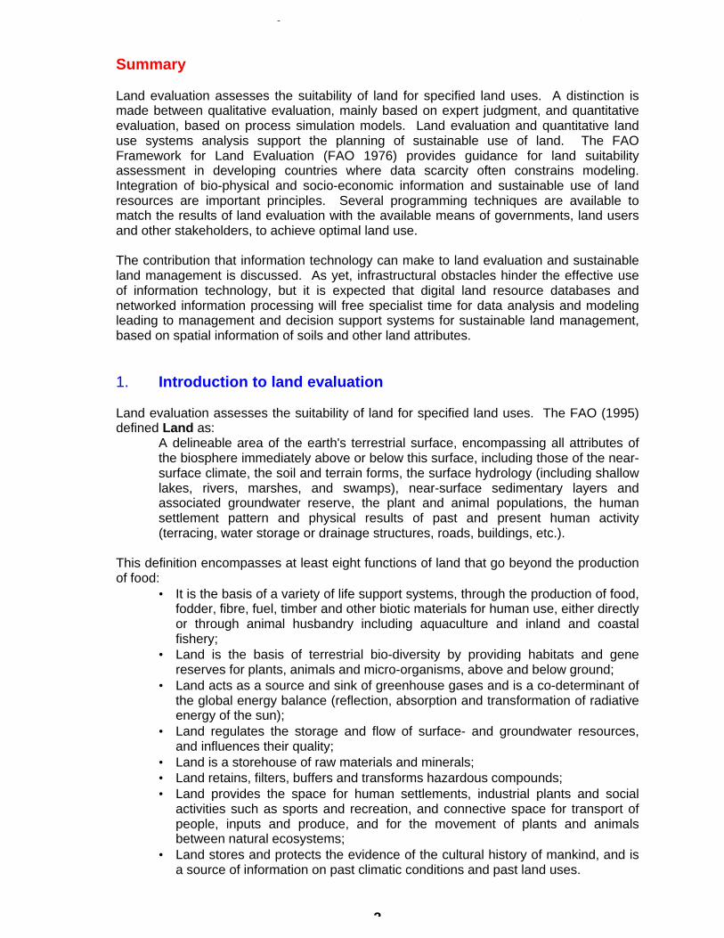
Land capability classification is a qualitative system that was developed by the USDepartment of Agriculture, in the nineteen thirties, as part of an erosion control program(Klingebiel and Montgomery 1961). Land capability refers to the potential of land tosustain a number of predefined land uses in a built-in descending sequence of desirability:arable crops, pasture, woodland, recreation/wildlife (Figure 1). If the capability of landdecreases, the land becomes suited for fewer major land uses. Land capability isassessed by comparing the characteristics of a land mapping unit with critical limits set foreach capability class. To obtain limits for the capability classes, expert knowledge wasrelated to land characteristics. Sub-classes indicate kinds of limitation while capabilityunits aggregate management recommendations according to technology and productivitylevels of farming in the USA.
Figure 1. General outline of a land capability classification system(adapted from McRae and Burnham 1981).
Land capability classification is primarily supportive to the planning of large farms and itaugments land use planning, e.g. balance the need for agricultural land against urbandevelopment or forest land against agriculture or pasture development. In doing this, theland capability classification has made an important contribution to the development ofland use planning and management.
The Framework for Land Evaluation (FAO 1976) is meant particularly for use in areas withlimited availability of basic data and can function at several levels of detail. The FAOFramework received conceptual inputs from the reconnaissance soil survey interpretationmethods in Brazil (Bennema et al. 1964, Romalho et al. 1995). Most applications arequalitative, matching degrees of limitation or 'quality' of the land with the correspondingrequirements of specific kinds of land use, and the overall suitability class is usually basedon the most severe limitation of the land. However, the principles underlying theFramework are equally valid in quantified methods:
C B A C B A
Land Use 2 Land Use 1
Lan
d U
se 3
Lan
d U
se 4Land
Capa- bility Class
Intensive Use Possibilities
Moderate Use Possibilities
Limited Use Possibilities
Suited for Specified Use
I
II
III
IV
V
VI
VII
VIII
A
B C
Preference of Land Uselow high

Land Evaluation for Sustainable Land Management Beek, de Bie, Driessen
5
• Evaluation of land, not just soil;• Prediction of response to future conditions must be facilitated;• Land suitability must be for specific land uses;• Evaluation should be in terms of benefits obtained in relation to inputs;• Evaluation must be related to local physical and socio-economic circumstances;• Land suitability is for use on a sustainable basis (without degradation of the land
resources);• All the relevant kinds of land use should be compared;• A multi-disciplinary approach is needed.
The Framework assesses the suitability of land mapping units for specific land use types(LUTs). The procedure starts by identifying relevant LUTs. Definitions of LUTs includelevels of know-how, available technology and available inputs and also the land tenuresituation in as far as it indicates the degree to which the land user can manage orovercome constraining land qualities/limitations. Subsequently, the land use requirements(LRs) of present and probable LUTs are matched with the defined land conditions. Theland conditions are described as dynamic regimes or 'land qualities' (LQs) that have adirect effect on the use. Examples of land qualities are the soil fertility level, wateravailability, oxygen availability, workability, resistance to erosion or salinization and thesequalities may be described more clearly in terms of sufficiencies, e.g. sufficiency ofnutrients, water etc. for the defined LUT (Melitz 1986).
The degree of quantification and detail of the description of land qualities over time, andthe description of individual LUTs depend on the available data, which in turn depend onthe scale of the analysis. Scale is an important factor when comparing the value ofdifferent land capability/evaluation systems.
At small scale, e.g. continental or country level (FAO 1981), the FAO has published semi-quantified methods, e.g. for assessing the population supporting capacity of land by agro-ecological zone. In this trade off between comprehensiveness and accuracy, potentialconstraint-free biomass production is determined on the basis of fourteen thermal regimes.The land is then sub-divided according to lengths of possible growing period (LGP), i.e. theperiod when moisture is sufficient for plant growth. Further reduction factors on yield arebased on constraints caused by pests and diseases as common in each zone. This part ofthe evaluation is worked out for standard sets of basic data, and for eleven different crops.The soils are individually assessed on the basis of expert knowledge on the effect of soilconditions on the growth of each crop (at different input levels) in the various LGP-zones.This was done because soil data and the understanding of the effects of soil properties oncrop yield are not fit to support quantified land evaluation on a country or continental scale.Applied at country level in Kenya (FAO/IIASA 1993), agro-ecological zoning resulted in aland productivity data set that was matched with the goals and objectives of governmentand local users. In this two-stage approach, subsequent socio-economic analysisestimated what land distribution would optimally approach the set goals. The analysis wasbased on linear and non-linear programming methods and employed multi-objectivefunctions which, in principle, enable the interests of different stakeholders to be combined.
The FAO Framework for Land Evaluation combining computer technology and expertknowledge on specific soils and crops has been demonstrated by several authors (Woodand Dent 1983; Jones and Thomasson 1987; Hong Cheng 1989; Robert 1989 and others).However, transferability of the analyses is limited because the expert knowledge appliesonly to the conditions for which the systems have been developed and calibrated.

Land Evaluation for Sustainable Land Management Beek, de Bie, Driessen
6
5. Interdisciplinary approach
The Framework employs the concept of relevant land use type and its associated crop andmanagement requirements. These requirements include both the bio-physicalrequirements and socio-economic setting. A choice is offered between a two-stage landevaluation procedure where the bio-physical analysis is followed by a socio-economicanalysis, which is preferred by most physical scientists, and a parallel procedure thatattempts to integrate bio-physical and socio-economic analyses. The latter is favored by(social) scientists, especially at the farm level. An integrated sequence of land evaluationand farming systems analysis procedures, based on new tools such as relationaldatabases, geographical information systems and modeling techniques, was proposed byFresco et al. in 1992.
Physical, process-oriented land evaluation (Bouma et al. 1993), in alliance with cropgrowth theory (De Wit et al. 1978), yields quantitative assessments of inputs, outputs andthe variable states of land qualities. Although such process-oriented modules supportoverall land suitability assessment, they are in the first place applied to producequantitative expressions of land qualities for physical land evaluation, e.g. crop growthpotential and water-limited bio-physical yield, the uptake of nutrients by crops, and erosionhazards / losses.
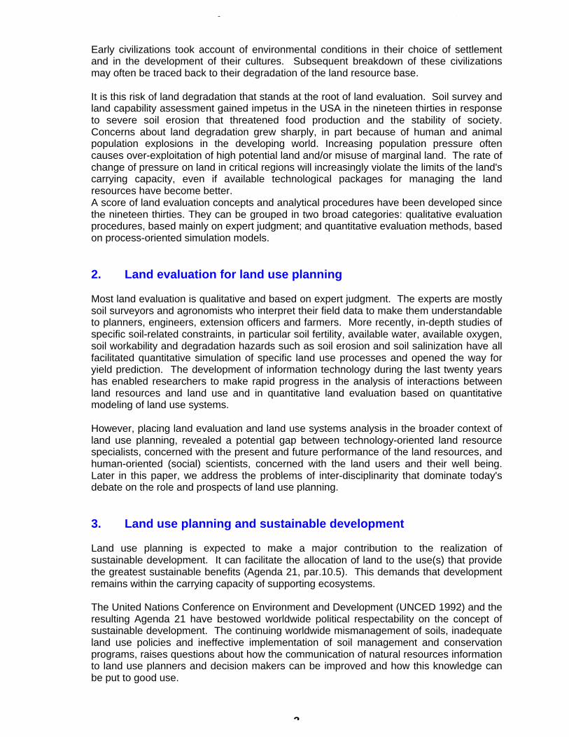
Coordination with social scientists and combining biophysical results with a socio-economic analysis needs to be structured. The FAO (1995) advocates decision-supportsystems, in which physical land evaluation and socio-economic evaluation run parallel forplanning of sustainable use of land resources (see Figure 2).
Land Evaluation Socio-Economic Evaluation
LAND USEOPTIONS
8Select best land use
7Carry out a multiple goal optimalization exercise to maximise achievement of desired objectives
6For each Land Managent unit identify:
1. possible crop(s) or products2. possible production systems3. yield levels for each input/output ratio4. risk factor5. environmentalinpact
5Identify Land
Management Units
1Land Resource
Database
3Economic Database
4Social Factors
2Land Use Database
1. costs of inputs2. sale prices
1. crop requirements2. production systems
1. objectives2. resources
1. soil2. climate3. other
Figure 2. Decision Support System for Land Use Planning (FAO 1995).

Land Evaluation for Sustainable Land Management Beek, de Bie, Driessen
7
Stoorvogel (1995), for purposes of land use planning in a Costa Rican rural settlement,linked external biophysical models with a Geographical Information System (GIS), applyinglinear programming for the analysis of alternative land use scenarios at farm and fieldlevels. Six consecutive steps were identified:
• geometry operations of farms and soil types;• attribute operations;• data export from the GIS to the external model;• model run;• data import from the model into the GIS and,• visualization or spatial analysis of the model results with the GIS, providing an
indication of maximal net farm income, as well as a quantification of specificsustainability factors such as biocides.
Schipper et al. (1995) used in this study area the same land use planning methodologycalled USTED (Uso Sostenible de Tierras en el Desarrollo) to analyze the impact onsustainability of policy measures at changing socio-economic conditions such as areduction in market price of a particular commodity grown in the area or of an importantinput like biocide and of quantitative restrictions on biocide use and soil nutrient losses.
Huizing and Bronsveld (1994) used GIS and bio-physical modeling to calculate the effectof crop diversification, changing from maize to tamarind on erosion losses and on incomeper village in an area of Thailand.
The above examples of bio-physical process models in combination with GIS and socio-economic analysis have been selected to demonstrate a certain change of paradigmthrough interdisciplinary land evaluation and land use planning from the traditional mono-disciplinary scientific study of soils, mostly of a descriptive nature (e.g. soil survey andclassification) to an inter-disciplinary study of integral land-use systems, leading toquantified prescriptions for optimal utilization (Figure 3).
Multi / Interdisciplinary
Mono-disciplinary
Science / technologydriven
Society / problemdriven
Trends
Figure 3. Trends in approach to problem solving.
Land Evaluation for Sustainable Land Management Beek, de Bie, Driessen
8
Comparing the contents of the soil science conferences in Latin America, and in Brazil inparticular near the 1960’s, this change of paradigm is very remarkable. Most soil researchin Brazil is nowadays dedicated to the dominant limiting factor: soil fertility, while in the1960’s, the soil surveyors played a dominant role to inventorize the spatial distribution ofpre-dominant soil problems and possibilities. The challenge for the future lies in theintegration of geographical information with all other scientific research results intopractical management and decision support systems for the different levels of aggregationrequired for sustainable land management. Information technology and a systemsapproach will help to overcome the traditional communication problem betweendisciplines. It should be noted that integration of bio-physical disciplines may be difficult,integration with the socio-economic disciplines is even more difficult.
Factors, which complicate interdisciplinary communication include:• the culture of individual disciplines;• the kind of knowledge involved;• the nature of development problems;• the institutional setting;• differences in perception of problems between the producers and the users of
(geo-graphical) information.
Universities often emphasize mono-disciplinary study, and the prestige of scientists ismore often derived from publications in a highly specialized scientific journal. Inter/multi-disciplinary research has at the moment a lower standing than mono-disciplinary research.This complicates the search for solutions to environmental problems and for sustainabledevelopment.
6. Sustainable land management: a land use system approach
The term sustainable development can be criticized for being open to a wide range ofinterpretations. According to Olembo (1994), the confusion arises because "sustainabledevelopment", "sustainable growth" and "sustainable use" have been appliedinterchangeably as if their meanings were the same. Sustainable growth is a contradictionin terms. Nothing physical can grow indefinitely. "Sustainable use" is applicable only torenewable resources: it means using them at rates within their capacities for renewal.
Dumanski’s (1993) definition of Sustainable Land Management (SLM) is:
Sustainable Land Management combines technologies, policies and activities aimedat integrating socio-economic principles with environmental concerns tosimultaneously:• maintain or enhance production and services;• reduce the level of production risk;• protect the potential of natural resources and prevent degradation of soil and water
quality;• be economically viable;• be socially acceptable.
National and local governments, interest groups, and specifically the land usersthemselves, should make efforts to meet these criteria. The objectives of many land usersare to 'maximize production and/or net profit' and to 'reduce costs and labour'. Equallyimportant to land users, planners and policy makers alike is the aim to 'conserve theenvironment'.

Land Evaluation for Sustainable Land Management Beek, de Bie, Driessen
9
The Brazilian land evaluation method (Ramalho 1995) recognizes that differentmanagement levels due to societal differences have to be taken into account whenevaluating the suitability of land. Different management levels may lead to different levelsof sustainability. Winsemius (1995) uses the term “environmental hierarchy of needs”,referring to the American psychologist Abraham Maslow (Figure 4). In this hierarchy aperson can move only to the next level of sustainability after fulfilling his needs at a lowerlevel. Thus, if within a society certain categories of land users are occupied fulfilling needsat a lower level (e.g. hunger is not satisfied; subsistence farming), then land use anddegrees of sustainability are dominated by this unfulfilled need.
Figure 4. Environmental hierarchy of needs (Winsemius 1996).
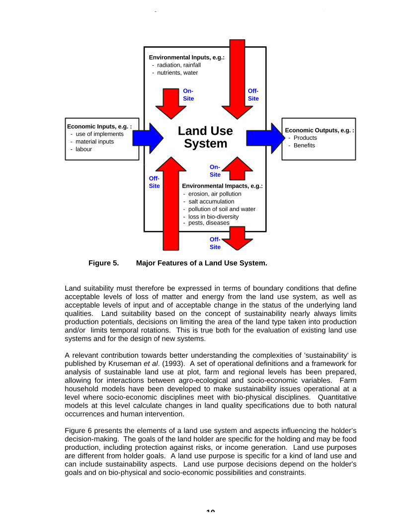
The use of land resources takes place in the context of land use systems. Figure 5 showsthe major features of a land use system. Sustainable land use systems can be evaluatedat scales from farm plots to country and global scale. Ecological sustainability can only beadequately defined with reference to specific spatial and time scales. Processes externalto the system may act at different time scales from the internal processes. Also, theacceptability of certain degrees of land degradation depends on the time and spatialscales concerned; for example deterioration of chemical soil fertility, soil pollution or soilerosion may be acceptable for particular local communities if this degradation occurs insmall patches and at a slow pace, assuming that new technology or adapted managementwill eventually put the situation back under control.
Environmental hierarchy of needs
Level of needs
Sustainable development
Ecosystem quality
Indirect threatsto human health
Utilization of space
Direct threatsto human health
Selected naturepreservation/
recreation
First necessitiesof life
5.Self actualization
4. (Self-) respect
3. Acceptanceby others
2. Safety and security
1. Physiologicalneeds
Physicalquality line
Public healthline
Land Evaluation for Sustainable Land Management Beek, de Bie, Driessen
10
Figure 5. Major Features of a Land Use System.
Land suitability must therefore be expressed in terms of boundary conditions that defineacceptable levels of loss of matter and energy from the land use system, as well asacceptable levels of input and of acceptable change in the status of the underlying landqualities. Land suitability based on the concept of sustainability nearly always limitsproduction potentials, decisions on limiting the area of the land type taken into productionand/or limits temporal rotations. This is true both for the evaluation of existing land usesystems and for the design of new systems.
A relevant contribution towards better understanding the complexities of 'sustainability' ispublished by Kruseman et al. (1993). A set of operational definitions and a framework foranalysis of sustainable land use at plot, farm and regional levels has been prepared,allowing for interactions between agro-ecological and socio-economic variables. Farmhousehold models have been developed to make sustainability issues operational at alevel where socio-economic disciplines meet with bio-physical disciplines. Quantitativemodels at this level calculate changes in land quality specifications due to both naturaloccurrences and human intervention.
Figure 6 presents the elements of a land use system and aspects influencing the holder’sdecision-making. The goals of the land holder are specific for the holding and may be foodproduction, including protection against risks, or income generation. Land use purposesare different from holder goals. A land use purpose is specific for a kind of land use andcan include sustainability aspects. Land use purpose decisions depend on the holder'sgoals and on bio-physical and socio-economic possibilities and constraints.
Economic Outputs, e.g. : - Products - Benefits
Land Use System
Economic Inputs, e.g. : - use of implements - material inputs - labour
Environmental Inputs, e.g.: - radiation, rainfall - nutrients, water
- pests, diseases
Environmental Impacts, e.g.: - erosion, air pollution - salt accumulation - pollution of soil and water - loss in bio-diversity
On- Site
Off- Site
On- Site
Off- Site
Off- Site

Land Evaluation for Sustainable Land Management Beek, de Bie, Driessen
11
Figure 6. Elements of a land use system with attributes that influence theholder's decisions. Flows of information and materials withinthe Land Use System are not shown (adapted from: de Bie et al.1996).
In a land use planning exercise it is important to distinguish between the stakeholder at thefarm level, here called the holder, and other interested parties which can be individuals,communities or government entities that have a traditional, current, or future right to co-decide on the use of the land in a planning exercise (FAO 1995).
A land use systems approach reveals that decisions have:
• a bio-physical component, dealing with the bio-physical performance ofspecific land use systems (at various scales);
• a socio-economic component, the decision-making process itself.
Land users/holders are at the interface between the bio-physical and socio-economiccomponents. The knowledge, flexibility and awareness of the holders are vital tosustainable land management. Local, regional, national and global governments andorganizations, are responsible for:
• the socio-economic framework (including tenancy arrangements);• the knowledge and awareness of the land users/holders (through extension
services);• the technology for sustainable land management (through research).
4
3
2 Soil / TerrainClimate / Weather
Vegetation(Crops / Flora)
Wildlife (Fauna)
Inf rastructure
Land UsePurposes
________
OperationSequence
1. Requirements & Suitability2. Productivity3. Decision Making / Planning4. Impact on Environment5. Grazing by Livestock6. Impact of Management on Land (pos. or neg.)
Land UseLand
Land Use System
6
Other Land Use Systems
Livestock Systems
5
Context LandUser(s)
Outputs/
Benefits
Inputs / Implements
Bio-Physical Conditions
Socio-Economical ConditionsGoals
1
Species Habitats(Bio-diversity)
Wetlands
Forests
National Parks andBuffer Zones
Agricultural Fields
Grazing Lands
Systems studied
Land Evaluation for Sustainable Land Management Beek, de Bie, Driessen
12
7. A sustainable land management model (SLM model)
The UNCED conference in 1992 and Agenda 21 identified the importance of widelyaccepted indicators by which to monitor the status of the environment. Recently the WorldBank initiated the development of Land Quality Indicators (LQIs) to enable monitoringchanges in land resources and the sustainability of managed eco-systems (Pieri et al.1995). The LQI concepts are somewhat different from the land quality concept of the FAOFramework for Land Evaluation. Distinctions are made between:
• Pressure indicators - indicators of pressures exerted upon land resourcesby human activities;
• State indicators - indicators of the state of land resources and,specifically, of changes over time;
• Response indicators - indicators of the response by society to pressuresand to changes of the state of land qualities.
State indicators are similar to the land qualities of the FAO Framework. However, theWorld Bank approaches them from a dynamic point of view, distinguishing between:
• Descriptive state indicators, which provide information in absolute terms, onland quality state or change of state;
• Performance indicators, which relate descriptive indicators to predeterminedstandards or target values (a kind of land suitability classes in terms of landevaluation).
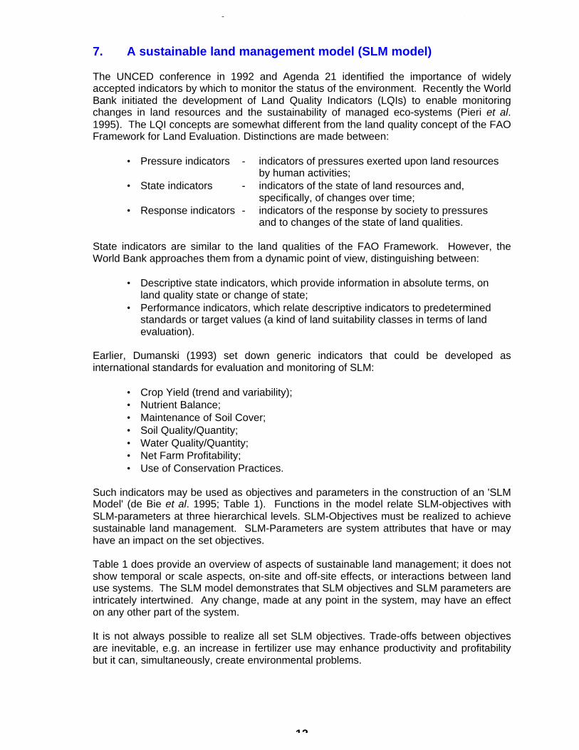
Earlier, Dumanski (1993) set down generic indicators that could be developed asinternational standards for evaluation and monitoring of SLM:
• Crop Yield (trend and variability);• Nutrient Balance;• Maintenance of Soil Cover;• Soil Quality/Quantity;• Water Quality/Quantity;• Net Farm Profitability;• Use of Conservation Practices.
Such indicators may be used as objectives and parameters in the construction of an 'SLMModel' (de Bie et al. 1995; Table 1). Functions in the model relate SLM-objectives withSLM-parameters at three hierarchical levels. SLM-Objectives must be realized to achievesustainable land management. SLM-Parameters are system attributes that have or mayhave an impact on the set objectives.
Table 1 does provide an overview of aspects of sustainable land management; it does notshow temporal or scale aspects, on-site and off-site effects, or interactions between landuse systems. The SLM model demonstrates that SLM objectives and SLM parameters areintricately intertwined. Any change, made at any point in the system, may have an effecton any other part of the system.
It is not always possible to realize all set SLM objectives. Trade-offs between objectivesare inevitable, e.g. an increase in fertilizer use may enhance productivity and profitabilitybut it can, simultaneously, create environmental problems.

Land Evaluation for Sustainable Land Management Beek, de Bie, Driessen
13
Table 1. Sustainable Land Management Model at three hierarchical levels(Beek, de Bie and Driessen, 1996)
SLM-Objectives SLM-Parameters
1. Land use system (LUS) level: (Land management takes place here; it is strictly bio-physical)
• Get target benefits• Achieve set yield targets• Avoid production variability and a
negative production trend• Conserve the environment, i.e.: - soil quality/quantity - water quality/quantity - nutrient balances - others
= f
• Land conditions: - climate/weather - landform; soil - flora; fauna (incl. crops & livestock) - infrastructure• (→2) Management aspects as based on land
use purposes, e.g.: - maintenance of soil cover - use of conservation practices
2. Holding level: (The land user/holder acts here; relevant decisions on SLM are made)
• Decisions on (modified) land usepurposes and management aspect:
- to maximize the level of holding's profit/production - to reduce costs and the use of non-renewable inputs - to optimize available labour use - to conserve the environment
= f
• (→1) Condition of holdings fields• (→3) Socio-economic setting• (→3) Acquired SLM-knowledge• (→3) Tenancy arrangements by parcel• Indigenous LUS-knowledge• Flexibility, awareness, social acceptance• Household specifications• Off-farm economic activities
3. Local, regional, national, and global levels:
• Create the required socio-economicframework, e.g.:
- to maintain food security - to generate wealth/welfare - to preserve biological production potentials - to protect rural landscapes - to prevent excess production• Develop SLM technologies• Extension of SLM technologies• Improve tenancy arrangements land
property rights
= f
• (→1) LUS aspects• (→2) Holding aspects• Rural infrastructure and facilities• Incentives; input/product prices• Legislation, e.g. on: - land conversion rates / urbanization of good lands / use of marginal lands - inputs, implements, land use operations• Long-term development policies, support, and
investment programs• Agricultural support systems and institutional
structures• Trading opportunities
Land Evaluation for Sustainable Land Management Beek, de Bie, Driessen
14
8. Information technology (IT) and SLM
The Atlantic Institute which is a kind of Think Tank of a number of faculties from the NE USA and E.Canada and some European ones met in Vienna in 1994 and coming to the conclusion that:
• we are shifting towards a field that nowadays is often called geomatics, defined by this AtlanticInstitute as the scientific “management of spatial information”. The boundaries between formerlyseparate disciplines become more and more fuzzy.
• We are moving from the period of innovation (1960-1980: technology driven, little data) throughthe period of integration (1975-2000 : building databases) to a period of proliferation (1990 -:systems integration, mass market, information marketplace customer driven).
Information technology (IT) is the combination of computers, electronic communication and processtechnology. Where IT is being introduced, in the financial service industry, in construction design, orother applications, a number of related generic characteristics emerge which are worthwhilementioning. Recognizing them helps in understanding trends and identifying what changes in thecollection, processing, and use of geographic information can be expected, but also in assessingthe organizational, institutional and human resource effects. The characteristics are as follows:
• integrating, of both production processes and information• decentralizing of production processes• customizing of processes and information products
Simplistically speaking the integration of production processes occurs through the software in whichtechnical, previously often specialized human activities are encoded. An example of this is desk toppublishing, GIS, accounting and management information systems, Global Positioning Systems,Total Survey Station, Digital Photogrammetry and Digital Cartography. The issue here is that whenpreviously is surveying and mapping specialized technical skills were required, and on which a lot ofemphasis was given in education, we now find that non-technically specialized people can operatethese systems and get out of them what they need.When these integrated systems are combined with communication technology, opportunities arisefor the decentralization of production processes as closely as possible to the user.This puts into question the need for large production facilities which were centralized so that thespecialized human skills could be coordinated into effective operations usually devoted to satisfyingmany different users with one standard product.
The integration of information is facilitated by the IT. Already this is clearly visible in themanagement decision support systems which grew out of the management information systems. Itis also visible that the capacity to combine digital data sources is leading to many questions aboutthe privacy of the individual and of corporations.GIS is of course a direct result of this integrating characteristic. It is clear that GIS put capacities inthe hands of the user community which are on the one hand unprecedented in their potential but onthe other hand provides challenges to existing power centers.The customization characteristic of IT relates to the capability to transform a data set at relativelylow cost into new information products for specific users.
An important consequence of the customization and integration characteristics of IT is that a certaindata set in combination with other data sets can deliver new information products with an addedvalue compared to the individual data sets. This leads to the notion of information as a basiceconomic resource. Like a primary natural resource it can be refined and enriched to new products.
To give you an example of economic data use:
The World Development Report 1994 of the World Bank, is this year concentrating oninfrastructure: roads, energy, water supply, etc. The conclusion is, that developing countriescan save up to 55 million dollars per year through a better management and maintenanceof their physical infrastructure, this means 25% of the total annual investment ininfrastructure.In Africa for instance timely investment of 12 million dollars in road maintenance during thepast 10 years could have saved an actual cost of 45 million dollar in road repairs. One of

Land Evaluation for Sustainable Land Management Beek, de Bie, Driessen
15
the reasons for their inefficiencies are monopolistic state companies. Decentralization leadto remarkable improvements of road quality and in the efficiency of water and energysupply, especially in combination with privatization and realistic pricing policies. Suchprocesses of decentralization and privatization are best served by an adequate informationinfrastructure!.
Information technology has significance for interdisciplinary land use planning infacilitating:
• decentralization of Governance• sustainable use of natural resources• great progress in communication• open international market for technology and knowledge.
At present, digital databases are being developed to create the information infrastructurerequired for sustainable land management at various scales. UN organizations supportedby specialized institutes are in the process of establishing data standards and developingsoftware for the collection and analysis of geo-referenced information on climate, soil andterrain conditions, water resources, land use, land cover and bio-diversity, socialconditions, and economic conditions. All these must be based on up-to-date and accuratetopographic databases and cadastral information. National programs are needed to unitesuch databases in a uniform geo-information infrastructure. The formalization of basiclandscape-ecological units as the basis for land use planning should be encouraged.
A significant cost element in geo-information exploitation in the establishment andmaintenance of the relevant standardized databases, their up-dating and interoperability.Groot (1993) developed a model (Figure 7) for a Geo-information Infrastructure (GIT) toachieve cost-effective data sharing from different sources, however, requiring policies andstandards that provide the legislative, regulatory, financial operating environment ofpredictable integrity. Its creation demands negotiating agreements defining the institutionalenvironment and arrangements between database producing and using information.
Figure 7. Geo-information Infrastructure (GIT) Model (Groot 1993).
*Geology*Water*Soil*Vegetation*Other
ITManagementOrganisation
Managementservices
Managementcontract
GeoinformaticsServer
(Env. Sector)
Basic geometry*Geodesy*Topographic framework*Adm. Boundaries*Geogr. Names*Other
Institutional structure forManagement and Financingof Geoinformatics server(Environment Sector)
Geoinformaticsserver for
OTHER SECTOR
Subject area 3
Subject area 1
Subject area 2
User sectorl.e. Environment
Two way data/information flowTwo way financial flowPolicy direction
*Standards*Financing*Access/use*Rate structure*R&D*Education*Legisiation*Integrety*Other
Policy direction
Land Evaluation for Sustainable Land Management Beek, de Bie, Driessen
16
To achieve this, the European Union sponsors the European Umbrella Organization forGeographical Information (EUROGI) to develop a Geo-information policy framework forEurope. Worldwide, the Open GIS Consortium is a similar initiative that started by US-based GI-industries. Expected is, that Internet will play an important role in the systemsarchitecture.
Modern survey techniques, multl-scale/level approaches and for the maintenance of basicdata sets the role of high-resolution remote sensing are major issues for the spatialreferencing and data models. Sensitive issues are protection of intellectual property andcopyright as well as the financing of GIT: government or privately finance and/or operated.
The development of geographical information systems has dramatically increased thedemand for reliable geo-referenced data. GIS technology supports land use planning andmanagement decisions at all levels of detail. However, it must be realized that detailed oreven semi-detailed soil maps (on which farmers can identify their property) are stillextremely scarce, with the notable exception of the USA which has nationwide soil surveycoverage and a systematic data updating program at 1:25.000.
It seems unlikely, that all data, including soil data can be produced through conventialmapping techniques of professional institutions. There should be more participation of theland users, making use of their indigenous knowledge. In many instances, ranging fromthe Maya culture in Yucathan to the Tonga culture in the Zambesi valley of Zimbabwe(Cecarelli 1997) have farmers developed their own soil classifications and interpretations.
Gonzalez (1994) found promising prospects for incorporating indigenous soil information ina GIS for land use planning in Costa Rica.
Mafalacusser (1995) compared land evaluation for specific crops (maize, cassava andgroundnuts) as done by local farmers with the results of the FAO method, concluding thatbringing together areas of knowledge and experience (scientific and indigenous) mayprovide a more complete and elaborated intervention, capable of improving sustainableagricultural production.
Sombroek and Antoine (1994) list four important technical and organizational constraintsto the effective use of GIS technology, especially in smaller developing countries:
• The inadequate analysis of real-life problems as they occur at the household level andas they involve the integration of bio-physical, socio-economic and politicalconsiderations;
• The limitation in data availability and data quality at all scales, especially where theyrequire substantial field-level survey;
• The lack of common data exchange formats and protocols;• The inadequate communication means between computer systems, data suppliers and
users, e.g. caused by poor local tele-communication networks.
Zinck (1994) summarized six weaknesses in today’s soil studies in relation to theirapplication in Geographical Information Systems:
• the way the information has been presented;• the reliability of the maps;• the cost of soil survey;• the quantitative information needed for simulation models;• the selection of adequate digital technologies;• the user-orientations of the collected soil information.

Land Evaluation for Sustainable Land Management Beek, de Bie, Driessen
17
Also the geo-referencing of collected soil data may not always be sufficient, requiring therevisiting of the locations and the assistance of global positioning systems (GPS).
Burrough (1993/1994) puts forward the following proposals for improving theunderstanding of soil variability and the provision of pertinent geo-information for land useplanning:
• Record the geographic location of field observations (point-data) in the data-base.Global positioning systems will be of help for location definition;
• Soil boundaries need to be described in terms of the degree of change that occurs:sharp, gradual, fuzzy;
• Digital elevation models need to be included in the data-base to provide informationabout the landform related aspects of spatial variation of soil and climate;
• Ground-penetrating radar and other geophysical methods can contribute to sub-surfacesoil mapping in flat areas. (3-D modelling of sub-surface phenomena as applied in oil-exploration may often offer perspectives for continuous sub-surface soil modelling);
• Geostatistics and other methods for interpolation;• When sufficient point data are available, statistical interpolation techniques of
quantitative and qualitative data yield continuous maps as contour or grid cells.
Beek and Van Gils (1990/1992) described the prospects of remote sensing withcontinuous earth observation at different temporal and spatial resolutions for expandingthe direct collection of dynamic land resource attributes from point data to area data.
Conceptual models are normally based on conventional measurements and addresstraditional problems, often at different spatial and temporal scales. The well-known raingauge provides a good illustration. The common rain gauge taught us to think, andrecently to model, in terms of millimetres of rain per point location. For many purposes,however, "mm of rain" describes a land attribute and not the land quality. The "operationalvariable" for crop growth is available soil moisture. Remote sensing can give us a betterindication of land attributes (in this instance the satellite-measured vegetation index andcorrelated moisture availability). Moreover, remote sensing deals with areas rather thanpoints. We often see attempts to transform remote sensing measurements (e.g.,vegetation index or NDVI) and parameters (e.g., Leaf Area Index, LAI) into traditionalparameters (e.g., mm of rain) that are then interpreted in terms of biophysical quantity(e.g., crop production). Instead, we should attempt to build vegetation index-drivenmodels. Such models, fed by contemporary remote sensing technology, would make theuse of isohyet maps (for example) redundant. Examples of other dynamic land attributesthat can be mapped more directly (and by area!) using remote sensing technology includeevapotranspiration (by the heat balance) and drought (by vegetation index anomalities).
Metternich (1996), using radar and multi-spectral image data accompanied by field-levelsurveys, was able to monitor the likelihood of changes in salinity-alkalinity of soils/areasand to predict salinity-alkalinity hazards in the Cochabamba area of Bolivia.
In qualitative land evaluations we have never hesitated to use the boundaries of naturalvegetation types for correlation of soil/climate related land qualities such as availablemoisture and excess of water. Also present land use, often easier detectable than soils byremote sensing, reflects the boundaries of natural phenomena. In Brazil, thereconnaissance soil survey uses natural vegetation phases of the soil mapping units as anindication of water deficiencies.
Land Evaluation for Sustainable Land Management Beek, de Bie, Driessen
18
9. Conclusions and Perspectives
Conclusions
1. Soil surveys should acknowledge the importance of soil / landscape / land coverinteractions as well as land use processes to account for and monitor soil dynamics atdifferent scales of time and space. Such information is essential for the data base in anational geo-information infrastructure.
2. Soil scientists and agronomists should seek the cooperation with socio-economic
specialists, land-use planners and land users, in improving the existing land usesystems at farm level in terms of a sustainable land management. Implementation ofresearch requires the use of GIS and simulation modules for the development ofdecision support systems as needed to guide practical action. This may require somereconstruction of the professional models for practical purposes, simplification inrelation to intended purpose (“what is the problem”) and adaptation to the local meansof communication (Cox 1996) and of indigenous knowledge.
Perspectives
1. Information Technology will increasingly facilitate the development of integrated,quantitative studies of land use systems based on the simulation of dynamic land-useinteractive processes.
2. There is a strong tendency towards increased use of geo-informatics in the design of
interdisciplinary geo-information systems and decision-support systems for realizingsustainable land management at different scales and for specific user groups (ChuThai Hoanh 1996; Ceccarelli 1997). A digital geo-information infra-structure and policyframework is emerging for this purpose at global, regional, national and local levels.This will make a significant soil research output available that is now inaccessiblystored in archives and libraries.

Land Evaluation for Sustainable Land Management Beek, de Bie, Driessen
19
References
BEEK,K.J. AND H.A.M.J. VAN GILS, 1990/1992, Global and environmental monitoring; the challengeto educators. ISPRS Comm. VII Symposium; Victoria (BC), Canada: 17-21. Photogrammetryand Remote Sensing, 47, 51-58.
BEEK,K.J., C.A. DE BIE AND P.M. DRIESSEN, 1996, Land evaluation (FAO method) for sustainableland use planning and management: Status and perspectives. Presented at: Latin American SoilScience Congress, Aguas de Lindoia-SP., Brazil / ITC, Enschede, 24 pp.
BENNEMA,J. K.J.BEEK AND M.N.CAMARGO, 1964, Un sistema de classificatçao de capacidade de usoda terre para levantamento de reconhecimento de solos, Rio di Janeiro, Ministerio da Agricultura/ FAO, Mimeografado.
BOUMA,J., M.C.S.WOPEREIS, W.J.H.M.WÖSTEN AND A.STEIN, 1993, Soil data for crop soil models,pp. 207-220. In: Systems Approaches for Agricultural Development, Proceedings of anInternational Symposium, Kluwer, Dordrecht.
BURROUGH,P.A., 1993/1994, The technologic paradox in soil survey: New methods and techniquesof data capture and handling, pp 15-22. In: Zinck,J.A., 1994 (Ed.), Soil Survey: Perspectives andStrategies for the 21st Century. An international workshop for heads of national soil surveyorganizations; Nov.1992, ITC Publication 21, Enschede. / ITC Journal 1993,1, 15-23,Enschede.
CECCARELLI,T., 1997, Towards a planning support system for communal areas in theZambezi valley, Zimbabwe. ITC Publication, Enschede.
CHU THAI HOANH, 1996, Development of a computerized aid to integrated land use planning(CAILUP) at regional level in irrigated areas. ITC Publication, Enschede.
COX,P.G., 1996, Some issues in the design of agricultural decision support systems.Agricultural Systems, 51,3.
DE BIE,C.A., K.J.BEEK, P.M.DRIESSEN AND J.A.ZINCK, 1995, Towards operationalization of soilinformation for sustainable land management. Position Paper, Brazil Soil Conference, July 1995.ITC, Enschede, 20 pp.
DE BIE,C.A., J.A.VAN LEEUWEN AND P.A.ZUIDEMA, 1996, The land use database; A knowledge-basedsoftware program for structured storage and retrieval of user-defined land use data sets; User'sreference manual (v1.04, DOS). ITC Enschede / FAO Rome / WAU Wageningen.
DE WIT,C.T. et.al., 1978, Simulation of assimilation, respiration and transpiration of crops.Simulation Monographs, Pudoc, Wageningen, 141 pp.
DUMANSKI,J., 1993, Sustainable land management for the 21st century. Volume 1: WorkshopSummary. Compiled on behalf of the Organizing Committee. Proceedings of the InternationalWorkshop on Sustainable Land Management for the 21st Century. University of Lethbridge,Canada, June 20-26, 50 pp.
FAO, 1976, A Framework for land evaluation. Soils Bulletin 3. FAO, Rome. 72 pp.
FAO, 1981, Report on the Agro-Ecological Zones project; Vol.3: Methodology and results for Southand Central America. World Soil Resources Report 48/3, Rome.
FAO, 1995, Planning for sustainable use of land resources; Towards a new approach. FAO Landand Water Bulletin 2. Rome, 60 pp.
FAO/IIASA, 1993, Agro-ecological assessments for national planning: The example of Kenya. SoilsBulletin 67, Rome. 154 pp.
FRESCO,L.O., H.G.J.HUIZING, H.VAN KEULEN, H.A.LUNING, AND R.A.SCHIPPER, 1992, Land evaluationand farming systems analysis for land use planning (LEFSA). FAO Working Document. FAO,Rome / ITC, Enschede.
GONZALEZ R.M., 1994, GIS incorporating indigenous knowledge: The care of local soil classificationand utilization in Costa Rica. MSc thesis, ITC, Enschede.
GROOT,R., 1993, Making information technology work. ITC Journal 1993,3.

Land Evaluation for Sustainable Land Management Beek, de Bie, Driessen
20
HONG CHENG, 1989, The soil resource evaluation system (SRES) in the Pearl River delta, pp. 265-268. In: J.Bouma and A.K.Brecht (Eds.), Land Qualities in Space and Time. Pudoc,Wageningen.
HUIZING,H.G.J. AND M.C.BRONSVELD, 1994, Interactive multiple-goal analysis for land use planning.ITC Journal 1994,4, 366-373, Enschede.
JONES,R.J.A. AND A.J.THOMASSON, 1987, Land suitability classification for temperate crops, pp. 29-35. In: Beek, Burrough, and Mc.Cormack (Eds.), (1987). Quantified Land EvaluationProcedures. Proceedings of the Workshop on Quantified Land Evaluation Procedures, held inWashington DC, 27 April - 2 May 1986. ITC Publication 6, Enschede.
KLINGEBIEL,A.A. AND P.H.MONTGOMERY, 1961, Land capability classification. USDA AgriculturalHandbook No.210, Washington DC.
KRUSEMAN,G., H.HENGSDIJK AND R.RUBEN, 1993, Disentangling the concept of sustainability;conceptual definitions, analytical framework and operational techniques in sustainable land use.DLV Report No.2. CABO-DLO. Wageningen, 60 pp.
MAFALACUSSER,J.M., 1995, The use of indigenous knowledge for land use planning in a part of Xai-Xai district, Gaza province, Mozambique. MSc thesis, ITC, Enschede, 165 pp.
MCRAE,S.G. AND C.P.BURNHAM, 1981, Land evaluation. Clarendon Press, Oxford, 239 pp.
MELITZ, P.J., 1986, The sufficiency concept in land evaluations, Soil Survey and LandEvaluation 6,1, 9-19.
METTERNICH, 1996, Detecting and monitoring land degradation features and processes inthe Cochabamba valley, Bolivia - A synergistic approach. ITC Publication, Enschede.
OLEMBO,R.J., 1994, Can land use planning contribute to sustainability? pp 369-376 In:Fresco,L.O., L.Stroosnijder, J.Bouma and H.van Keulen (Eds.). The Future of the Land -Mobilizing and Integrating Knowledge for Land Use Options. John Wily & Sons, Chichester.
PIERI C., J.DUMANSKI, A.HAMBLIN AND A.YOUNG, 1995, Land quality indicators. World BankDiscussion Papers no.315. The World Bank, Washington, D.C. / FAO, Rome / UNDP, New York/ UNEP, Nairobi, 63 pp.
RAMALHO FILHO,A. AND K.J.BEEK, 1995, Sistema de avaliaçâo da aptidâo das terras. Rio diJaneiro, MAARA/EMBRAPA/CNPS 3a revisâo.
ROBERT,P.C., 1989, Land evaluation at farm scale using soil survey information systems, pp. 299-311. In: J.Bouma and A.K.Brecht (Eds.), Land Qualities in Space and Time. Pudoc,Wageningen.
SCHIPPER, R.A., D.M. JANSEN AND J.J.STOORVOGEL, 1995, Sub-regional linear programmingmodels in land use analysis: a case study of the Nehuev settlement, Costa Rica.Netherlands Journal of Agricultural Science, 43,1, 83-109.
SOMBROEK, W.G. AND J.ANTOINE, 1994, The use of geographic information systems in landresource appraisal. Outlook on Agriculture, London.
STOORVOGEL,J.J., 1995, Linking GIS and models: structure and operationalization for aCosta Rican case study. Netherlands Journal of Agricultural Science, 43,1, 19-29.
UNCED, 1992, Agenda 21. 1. Adoption of agreements on environment and development. 1.means of implementation. UNCED, Rio de Janeiro.
WINSEMIUS,P., 1995, Sustainable development - sustaining the pace, sustaining the planet.Presentation during the Clingendael series of The Netherlands-Canada / 1995Distinguished Lectures, The Hague.
WOOD,S.R. AND F.J.DENT, 1983, LECS: A land evaluation computer system. Manual 5:Methodology. Ministry of Agriculture, Bogor, Indonesia.
ZINCK,J.A., 1992, (Ed.). Soil survey: Perspectives and strategies for the 21st century. Aninternational workshop for heads of national soil survey organizations, Enschede. ITCPublication 21, 132 pp.