land administration in guyana · 2019-04-29 · recorded at deeds registry). ... land under such...
TRANSCRIPT

Land Administration in Guyana
Natural Resources for Sustainable Rural Development:
Access and Governance
Durwin Humphrey20 -23 noviembre del 2018 – Buenos Aires, Argentina

•
•
•
•
•

Venezuela to the WestBrazil to the SouthSuriname to the EastPopulation : 750,000

Administrative Regions (10)

Natural Regions

(imágenes de muestra)

Guyana’s Context
• Land in Guyana is owned either by the State or under private freehold tenure.
• There are two basic land markets. The first consists of freehold properties and the
second consists of leases of publicly owned land. There is also a minor market in leases
of freehold properties

Guyana’s Context
• In the freehold market, a purchaser buys outright from a seller under the "transport of property" or "transfer of certificate of title" transactions recorded at the Land & Deeds Registries respectively.
• All leases of publicly owned land are recorded at the Lands and Surveys Commission (Long Leases, 21 yrs & over, recorded at Deeds Registry).

• State lands, formerly called Crown Lands are those transferred at Independence in 1966, to the people of Guyana and became known as State lands under Section 3(b) of the State Lands Act Ch.62:01
There are two categories of publicly owned lands, namely, State lands and Government lands.

Government lands are those purchased by or granted to the Government of Guyana by the State to be developed with general revenue, for public purposes, such as land for hospitals, and schools, land development schemes, etc.

Administration of Private Lands
Freehold land administration is carried out by the Deeds Registry under the Office of Attorney General of the Supreme Court and by the Land Registry under the Office of the Minister of State.
There are two systems of land law and property recordings governing the private market, namely, the "transport index" based on Roman Dutch legal practices, and the "index of land transfer of title," that is, the Torrens system introduced in the early 1950s by the British

While the Commissioner of Lands and Surveys is the custodian of all State lands, the Guyana Lands and Surveys Commission in accordance with the State Lands Act and Regulations, the Guyana Forestry Commission, under Act 2 of 1979, and the Guyana Geology and Mines Commission, under the Act 9 of 1979, administer land use for agriculture (and other purposes), forestry and mining throughout Guyana, respectively

Accordingly, each of these three Government institutions issues titles for different purposes over
the same land space. The need for some rationalisation of authority in the allocation of
public land is, therefore, of some concern in the planning of future institutional arrangements.

State lands can be given out in one of three forms: a license, a permit or a
lease

Structure of Land Ownership and Distribution
• The State owns approximately 73% of the national territory. (Private 12%, Indigenous (Communal) 15%)
• In coastal areas where most of the population is concentrated, roughly half of farms are freehold properties
• Land tenure policy has undergone many changes over time. After 1831 the British alienated State lands under a form of title called "absolute grants."

Land Policy in Guyana
• The alienation of State lands under the systems of grants was suspended in 1938 because of the abandonment and poor development of large areas of land under such titles. The license of occupancy was the forerunner of the leasehold system
• The 99-year lease was adopted after 1912. The 21-year lease was introduced in 1919 and the 25-year lease was adopted about 1965 with the right of renewal. At present State lands are allocated under 50-year leases.
*(Guyana is now in the process of drafting an overarching National Land Policy)

• There are currently over 20,000 applications on record yet to be processed
• The process seems too complicated/cumbersome and results in regular frustrations for clients seeking access to land
• In some cases the process has taken over 15 years to complete processing a single application
• Much has improved recently, however, there is still much work to be done. The GLSC is working closely with FAO and other local and international stakeholders to address a number of these inefficient processes
Land Policy in Guyana

GLSC Act 1999 Chap. 59:05
The Guyana Lands and Surveys Commission was created in 1999 via an Act of Parliament to replace the former Lands and Surveys Department which functioned since the 1800s.

Surveying
Land Administration
Land Information & Mapping - GIS
Land Policy
& Planning

• Land Administration• Guyana Geology & Mines
• Guyana Forestry Commission

• Land Use Planning
• Central Housing & Planning Authority,
• Local Government,
• Oversight for Agriculture/Fisheries• Ministry of Agriculture

• Poor inter-agency coordination – “Turfism”• Lack of data sharing
• Duplication of efforts
• Poor Planning Framework/Mechanism
• Outdated maps (1970s) and base data
• Lack of Integrated Cadastre
• Lack of trained personnel – Capacity Deficit

• Lack of understanding of Legal/Policy Framework
• Lack of Financial Resources
• Poor ICT Infrastructure (Inter-connectivity) Non-
cohesive Legal/Policy Framework

• Separation of Valuation/Land Registry
• Poor Geodetic Infrastructure
• Paper-based system
• Lack of respect for Repository Function
• Lack of Comprehensive Strategic Plans

• Development of Continuously Operating Reference Station
(CORS) Network
• Development of new Land Surveying Standards
• National Spatial Data Infrastructure & National Geospatial Policy
• Improved capacity for Land Policy and Planning
• Development of National Land Policy which will give attention to
classification of lands and stronger land rights for farmers

• Commencement of Strategic Planning
• Strategies/ Business Model
• Sustainable Land Development and Management (SLDM) Project/FAO: Est. of
National Consultative Platform
• Acquisition of modern equipment and upgraded facilities
• Training and Equipment to establish a hydrographic Department
• Establishment of new Diploma and Degree courses with The University of
Guyana in Partnership with other International Universities. (LA, Surveying,
Valuation, GIS)

-Caribbean Soil Data Project (PISLM)-GLSC is the National Focal Point Agency to the UNCCD-Reclamation of Degraded Soils is a priority

-The Caribbean SoilCare Project aims to provide improved soil information, policy and technical support contributing to wide adoption of sustainable soil management and land use systems and Caribbean countries LDN targets (that deliver proven socioeconomic and environmental benefits).
-The project will also provide important data to inform Land Use Planning and a number of other key sectors
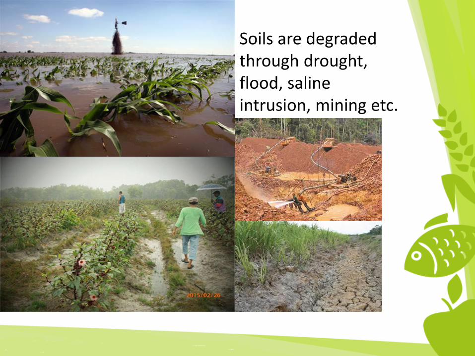
Soils are degraded through drought, flood, saline intrusion, mining etc.

THINK BIGSTART SMALLSTART NOW

Thank You