key points and the most significant documents in the...
TRANSCRIPT
AARMS GEOSCIENCE
Vol. 8, No. 1 (2009) 141–149
Received: May 14, 2009
Address for correspondence: IMRE FARKAS E-mail: [email protected]
Key points and the most significant documents in the production of the High Resolution Vector Data (HRVD)
within the Multinational Geospatial Co-production Program (MGCP)
IMRE FARKAS
Miklós Zrínyi National Defence University, Budapest, Hungary
The United States Defense Mapping Agency formulated the need for digital data created in a multinational co-production covering the entire surface of Earth, at the end of the eighties. Hungary was not among the 20 executor states (18 NATO Members, New-Zealand and Australia) because of this our country can only acquire the (VMAP Level 1) parts of the 1:250.000 data providing full coverage with separate mutual agreements within the limits of responsibility of each party. In April 2003, the United States National Geospatial-Intelligence Agency initiated the foundation of a program providing closer co-operation of defense mapping agencies, to create a geoinformation database that can satisfy the altered needs, this program is called the MGCP (Multinational Geospatial Co-production Program). The aim of the program is to create high scale digital geoinformation database of strategically significant territories. In this article we will discuss the key points of producing High Resolution Vector Data within the Multinational Geospatial Co-production Program (MGCP), especially the importance of the order of the data evaluation.
Introduction of the MGCP
The main goal of the Multinational Geospatial Co-production Program (MGCP) is the production of High Resolution Vector Data (HRVD) at the 1:50K and 1:100K map density from various sources. 28 member nations are currently participating in this joint effort. Approximately 3000 (1° by 1°) cells will be processed and the vector data will be stored in the International Geospatial Warehouse (IGW).
Each MGCP Member Nation is responsible for determining the best data sources and extraction methods in order to generate the HRVD in their assigned cells. It is accepted that the primary source for feature extraction will be Remotely Sensed Imagery (RSI). This program is in the early stages of defining the requirements for
I. FARKAS: High Resolution Vector Data in the Multinational Geospatial Co-production Program
142 AARMS 8(1) (2009)
feature extraction, attribution, and storage of the data. Data production started in 2006 with the expected completion of all MGCP assigned cells by December 31, 2011.1
The MGCP member nations should take note of the following operational principles and assumptions:
• All MGCP nations foresee a growing need for timely, relevant, and accurate geospatial data on a global scale.
• Government agencies, allied forces, and commercial industries desire more interoperability between Geographic Information Systems (GIS) and informational databases.
• Industry standards for geospatial data must be applied to ensure interoperability between systems and networks, which promote government agency, allied forces, and commercial industry cooperation. Current, viable technologies must be applied whenever and wherever possible to take advantage of new ideas which will increase responsibility, productivity, accuracy and security.
• The IGW will provide the MGCP nations with accessible and secure means to store and distribute information through the use of the “world wide web” (WWW) and Public Key Infrastructure (PKI) technologies.
Key points of the production of HRVD
1. Determining and checking the quality and availability of the very different type of raw data and data sources. a) Primary data sources In the production of HRVD (MGCP) the primary data source is a high resolution
aerial or satellite image. Some of the participating nations can collect Remotely Sensed Imagery themselves, but most of them must use satellite or aerial images made by commercial agencies.
Because of the wide range of type and quality of the available images, the evaluating organization must sort these primary data sources to decide which type is the most cost efficient, and gives better result for the HRVD.
The available raw materials can be sort by resolution (Ground Sample Distance), spectral information (number of bands, radiometry), the date of acquisition, price, quality, etc.
Universally the primary data sources are aerial or satellite images with high or very-high field resolution (about 1 meter or better), such as Ikonos, Quickbird or Kompsat satellite images. In Hungarian territory, the primary used data source was a set of aerial orthorectified images with the field resolution of 50 cm.
I. FARKAS: High Resolution Vector Data in the Multinational Geospatial Co-production Program
AARMS 8(1) (2009) 143
In other cases we used Ikonos, Quickbird, Kompsat pan sharpened multispectral images with 0.5 to 1 meter field resolution, or SPOT infrared images with 2.5 meter field resolution.
b) Secondary data sources In most cases using native maps, such as topographic maps, or native data bases,
such as register of villages as secondary or auxiliary data sources are very useful, and gives relevant assistance during the evaluation of the vector data and/or the related attribute data.
c) Auxiliary data sources Very high range of auxiliary databases can be used during the evaluation. Some of
them is listed below. – AAFIF (Automated Air Facility Information File) database, which contains
different kinds of information about airports, runways, etc. – DVOF (Digital Vertical Obstruction File) database, containing buildings and
structures higher than 45 meters above the surface. – GeoNames database, provided by the NGA (National Geospatial-Intelligence
Agency, USA). The GeoNames geographical database contains over eight million geographical names and consists of 6.5 million unique features whereof 2.2 million populated places and 1.8 million alternate names. All features are categorized into one out of nine feature classes and further subcategorized into one out of 645 feature codes.
– Native maps, e.g.. road maps are very useful to collect attribute data about roads, e.g. road names, national numbering, rates, etc.
2. Building hardware and software infrastructure a) Hardware infrastructure It depends on the selected software and database solution, but it is a fact that the
poor performance might slow down the evaluation of the HRVD. b) Software infrastructure Two major types of software infrastructures can be chosen, the ESRI’s ArcGIS or
the Intergraph’s Geomedia software systems. Any of them can be used with MS Access, or Oracle database connection. Hungary chose the second way: we use Intergraph Geomedia Software with Oracle database. Using this solution we expect to meet the requirements, e.g. the limited time requisite during the internal quality check and the edge matching procedures. 3. Determining the rules and the order of the evaluation
a) Common rules for the evaluation of the HRVD in the MGCP
I. FARKAS: High Resolution Vector Data in the Multinational Geospatial Co-production Program
144 AARMS 8(1) (2009)
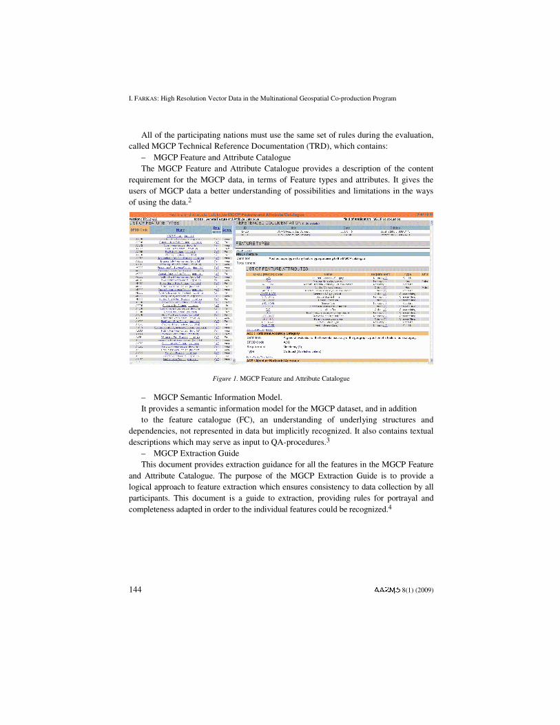
All of the participating nations must use the same set of rules during the evaluation, called MGCP Technical Reference Documentation (TRD), which contains:
– MGCP Feature and Attribute Catalogue The MGCP Feature and Attribute Catalogue provides a description of the content
requirement for the MGCP data, in terms of Feature types and attributes. It gives the users of MGCP data a better understanding of possibilities and limitations in the ways of using the data.2
Figure 1. MGCP Feature and Attribute Catalogue
– MGCP Semantic Information Model. It provides a semantic information model for the MGCP dataset, and in addition to the feature catalogue (FC), an understanding of underlying structures and
dependencies, not represented in data but implicitly recognized. It also contains textual descriptions which may serve as input to QA-procedures.3
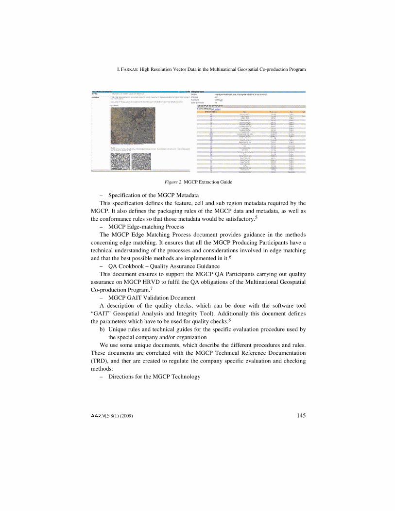
– MGCP Extraction Guide This document provides extraction guidance for all the features in the MGCP Feature
and Attribute Catalogue. The purpose of the MGCP Extraction Guide is to provide a logical approach to feature extraction which ensures consistency to data collection by all participants. This document is a guide to extraction, providing rules for portrayal and completeness adapted in order to the individual features could be recognized.4
I. FARKAS: High Resolution Vector Data in the Multinational Geospatial Co-production Program
AARMS 8(1) (2009) 145
Figure 2. MGCP Extraction Guide
– Specification of the MGCP Metadata This specification defines the feature, cell and sub region metadata required by the
MGCP. It also defines the packaging rules of the MGCP data and metadata, as well as the conformance rules so that those metadata would be satisfactory.5
– MGCP Edge-matching Process The MGCP Edge Matching Process document provides guidance in the methods
concerning edge matching. It ensures that all the MGCP Producing Participants have a technical understanding of the processes and considerations involved in edge matching and that the best possible methods are implemented in it.6
– QA Cookbook – Quality Assurance Guidance This document ensures to support the MGCP QA Participants carrying out quality
assurance on MGCP HRVD to fulfil the QA obligations of the Multinational Geospatial Co-production Program.7
– MGCP GAIT Validation Document A description of the quality checks, which can be done with the software tool
“GAIT” Geospatial Analysis and Integrity Tool). Additionally this document defines the parameters which have to be used for quality checks.8
b) Unique rules and technical guides for the specific evaluation procedure used by the special company and/or organization
We use some unique documents, which describe the different procedures and rules. These documents are correlated with the MGCP Technical Reference Documentation (TRD), and ther are created to regulate the company specific evaluation and checking methods:
– Directions for the MGCP Technology
I. FARKAS: High Resolution Vector Data in the Multinational Geospatial Co-production Program
146 AARMS 8(1) (2009)
This documentation contains detailed project descriptions including the name of the cells, the participating companies and organizations, the capital equipment, the data sources including the primary, secondary and auxiliary data sources. It also includes the detailed list of all the files belonging to the end product and which are necessary to deliver (e.g., feedback reports for the revived databases).
In this document we can find the structures of the participating organizations and all the information about the contact persons who are needed during the project flow.
The Direction for the MGCP Technology briefly describes the main technology steps for the data capture workflow as well as the self-check procedure of the operators.9
– Operators Direction This document is the most detailed description about the data capture and the
operators’ software-based self-check procedures. It contains detailed instructions about all the stages of the data capture, including the step-by-step evaluation guide.
The evaluation guide regulates the exact sequence to the capture of the different object types.
The Operators Direction regulates not only the order of the evaluation, but the nation specific list of mandatory and optional attributes as well.
After evaluating all the objects, the operators start a very strict self-checking procedure, which contains a very large number of software based topology and attribute check.10
– Internal Supervisors’ Direction This document is made for the internal supervisors only and contains detailed
descriptions about the usage of the data exchange systems (used between the three participating organizations in Hungary) These organizations are: Geodesy Co. Ltd., the evaluating company, the company, who provides separate quality check, and the end user organization, in this case the Hungarian Defense Forces Geoinformation Service.11 4. Evaluation
As the evaluation guide regulates, the exact sequence of capturing different object types follows:
First, the operator has to evaluate the network – such as objects (lines) of the transportation (roads, railways) and the hydrogeology. Within this phase the operator captures some non-line-type objects (points or areas) related to the transportation networks, and some objects related to the network of hydrogeology. After the evaluation of the “skeleton” (means the basic networks mentioned before) the operator captures the Landcover Area Features (called LAFs). These features form provide 100% land cover. Any of the LAF types, in principle, cannot overlap.
After this section of data capture follows the second digitizing step. In this step the operators evaluate the next large set of objects, called AAFs.
I. FARKAS: High Resolution Vector Data in the Multinational Geospatial Co-production Program
AARMS 8(1) (2009) 147
Activity Area Features (AAFs) are in general allowed to overlap each other and can also overlap the Other Area Features.
The evaluation of the OAFs (Other Area Features) follows the capturing of the Activity Area Features.12
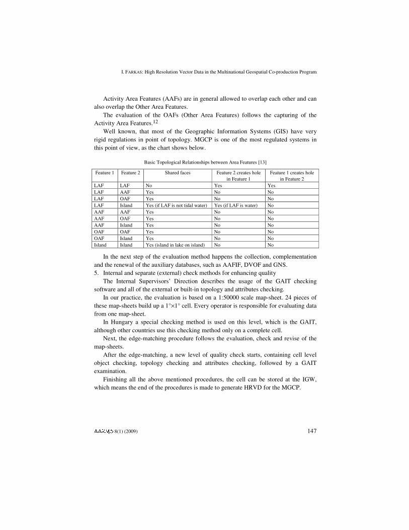
Well known, that most of the Geographic Information Systems (GIS) have very rigid regulations in point of topology. MGCP is one of the most regulated systems in this point of view, as the chart shows below.
Basic Topological Relationships between Area Features [13]
Feature 1 Feature 2 Shared faces Feature 2 creates hole in Feature 1
Feature 1 creates hole in Feature 2
LAF LAF No Yes Yes LAF AAF Yes No No LAF OAF Yes No No LAF Island Yes (if LAF is not tidal water) Yes (if LAF is water) No AAF AAF Yes No No AAF OAF Yes No No AAF Island Yes No No OAF OAF Yes No No OAF Island Yes No No Island Island Yes (island in lake on island) No No
In the next step of the evaluation method happens the collection, complementation and the renewal of the auxiliary databases, such as AAFIF, DVOF and GNS. 5. Internal and separate (external) check methods for enhancing quality
The Internal Supervisors’ Direction describes the usage of the GAIT checking software and all of the external or built-in topology and attributes checking.
In our practice, the evaluation is based on a 1:50000 scale map-sheet. 24 pieces of these map-sheets build up a 1°×1° cell. Every operator is responsible for evaluating data from one map-sheet.
In Hungary a special checking method is used on this level, which is the GAIT, although other countries use this checking method only on a complete cell.
Next, the edge-matching procedure follows the evaluation, check and revise of the map-sheets.
After the edge-matching, a new level of quality check starts, containing cell level object checking, topology checking and attributes checking, followed by a GAIT examination.
Finishing all the above mentioned procedures, the cell can be stored at the IGW, which means the end of the procedures is made to generate HRVD for the MGCP.
I. FARKAS: High Resolution Vector Data in the Multinational Geospatial Co-production Program
148 AARMS 8(1) (2009)
Conclusions
Such complex procedure, as the evaluation of the objects to make High Resolution Vector Data (HRVD) for the MGCP project using Remotely Sensed Imagery, definitely needs a very rigorous regulation. In this article there was an attempt to expose, enumerate and introduce these documents, and enhance the importance of these documents, especially the company based and nation specific directions, regulations. We pointed out the key points of determining the evaluation regulations and described the order of the evaluation and quality check methods, to briefly introduce the MGCP project workflow.
Appendix A: Definitions, Terms and Acronyms
GAIT – Geospatial Analysis and Integrity Tool GIS – Geographic Information System GSD – Ground Sample Distance (pixel size) HRVD – High Resolution Vector Data IBP – Imagery Benchmarking Process IGW – International Geospatial Warehouse MGCP – Multinational Geospatial Co-production Program NGA – National Geospatial-Intelligence Agency WGS84 – World Geodetic System 1984 WWW – World Wide Web– feature: abstraction of real world phenomena [ISO 19101]
– feature association: relationship that links instances of one feature type with instances of the same or a different feature type
– feature attribute: characteristic of a feature [ISO19101] – feature catalogue: catalogue containing definitions and descriptions of the
feature types, feature attributes, and feature associations occurring in one or more sets of geographic data, together with any feature operations that may be applied.
– feature type: In this context synonymous to class. – HRVD: High Resolution Vector Data – MGCP: Multinational Geospatial Co-production Program – model: abstraction of some aspects of reality
I. FARKAS: High Resolution Vector Data in the Multinational Geospatial Co-production Program
AARMS 8(1) (2009) 149
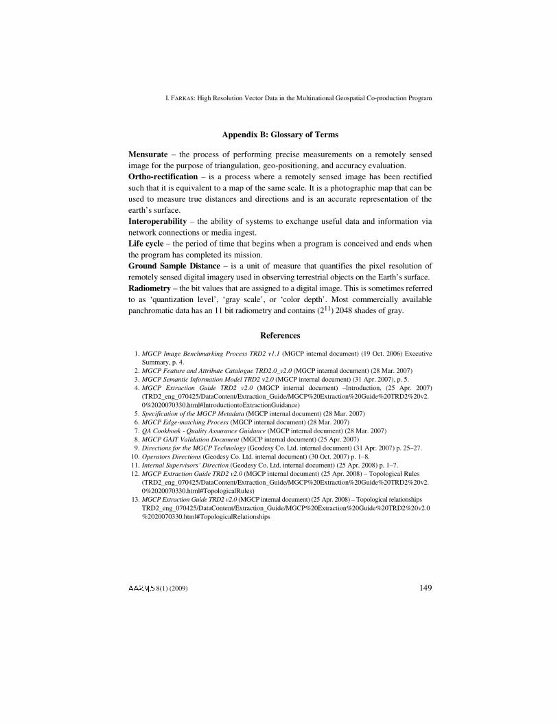
Appendix B: Glossary of Terms
Mensurate – the process of performing precise measurements on a remotely sensed image for the purpose of triangulation, geo-positioning, and accuracy evaluation. Ortho-rectification – is a process where a remotely sensed image has been rectified such that it is equivalent to a map of the same scale. It is a photographic map that can be used to measure true distances and directions and is an accurate representation of the earth’s surface. Interoperability – the ability of systems to exchange useful data and information via network connections or media ingest. Life cycle – the period of time that begins when a program is conceived and ends when the program has completed its mission. Ground Sample Distance – is a unit of measure that quantifies the pixel resolution of remotely sensed digital imagery used in observing terrestrial objects on the Earth’s surface. Radiometry – the bit values that are assigned to a digital image. This is sometimes referred to as ‘quantization level’, ‘gray scale’, or ‘color depth’. Most commercially available panchromatic data has an 11 bit radiometry and contains (211) 2048 shades of gray.
References
1. MGCP Image Benchmarking Process TRD2 v1.1 (MGCP internal document) (19 Oct. 2006) Executive Summary, p. 4.
2. MGCP Feature and Attribute Catalogue TRD2.0_v2.0 (MGCP internal document) (28 Mar. 2007) 3. MGCP Semantic Information Model TRD2 v2.0 (MGCP internal document) (31 Apr. 2007), p. 5. 4. MGCP Extraction Guide TRD2 v2.0 (MGCP internal document) –Introduction, (25 Apr. 2007)
(TRD2_eng_070425/DataContent/Extraction_Guide/MGCP%20Extraction%20Guide%20TRD2%20v2.0%2020070330.html#IntroductiontoExtractionGuidance)
5. Specification of the MGCP Metadata (MGCP internal document) (28 Mar. 2007) 6. MGCP Edge-matching Process (MGCP internal document) (28 Mar. 2007) 7. QA Cookbook - Quality Assurance Guidance (MGCP internal document) (28 Mar. 2007) 8. MGCP GAIT Validation Document (MGCP internal document) (25 Apr. 2007) 9. Directions for the MGCP Technology (Geodesy Co. Ltd. internal document) (31 Apr. 2007) p. 25–27. 10. Operators Directions (Geodesy Co. Ltd. internal document) (30 Oct. 2007) p. 1–8. 11. Internal Supervisors’ Direction (Geodesy Co. Ltd. internal document) (25 Apr. 2008) p. 1–7. 12. MGCP Extraction Guide TRD2 v2.0 (MGCP internal document) (25 Apr. 2008) – Topological Rules
(TRD2_eng_070425/DataContent/Extraction_Guide/MGCP%20Extraction%20Guide%20TRD2%20v2.0%2020070330.html#TopologicalRules)
13. MGCP Extraction Guide TRD2 v2.0 (MGCP internal document) (25 Apr. 2008) – Topological relationships TRD2_eng_070425/DataContent/Extraction_Guide/MGCP%20Extraction%20Guide%20TRD2%20v2.0%2020070330.html#TopologicalRelationships