kaiser-francis oil company application for directional drilling permits...
TRANSCRIPT
KAISER-FRANCIS OIL COMPANY APPLICATION FOR DIRECTIONAL DRILLING PERMITS
NMOCD Case No. 1 Q 8 8 7
PURE GOLD WELL LOCATIONS
Well: Surface: BHL:
Pure Gold 1950' FSL 2043' FNL
200' 456'
FEL FWL
( U n i t ( U n i t
I ) E)
Sec Sec
20 21
W e l l : Surface: BHL:
Pure Gold 10' FSL
1947' FNL
A-8 x 1935' x 1789'
FWL FWL
( U n i t ( U n i t
N) F)
Sec Sec
16 21
W e l l : Surface: BHL:
Pure Gold 10' FSL
480' FNL 280' 480'
FWL FWL
( U n i t ( U n i t
M ) K)
Sec Sec
16 21
W e l l : Surface: BHL:
Pure Gold 10' FSL
480' FNL
10 1800' 1800'
FWL FWL
( U n i t ( U n i t
N) C)
Sec Sec
16 21
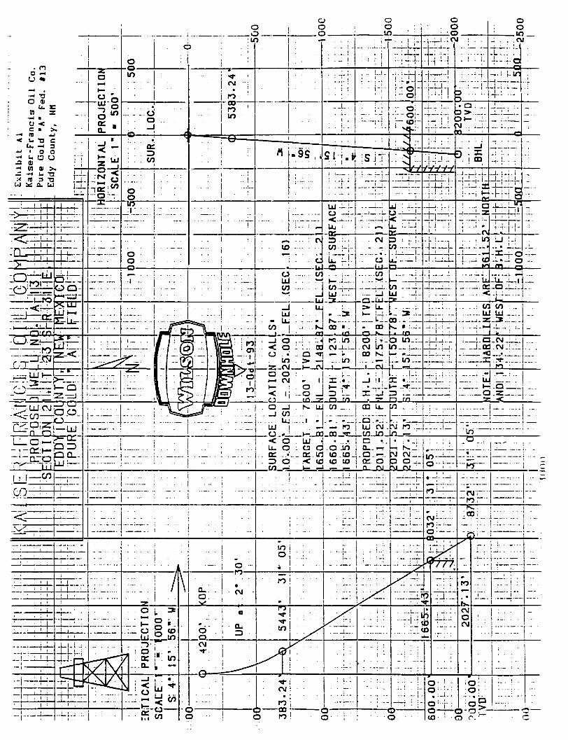
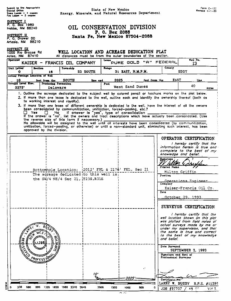
W e l l : Pure Gold A-13 Surface: 10' FSL x 2025' FEL ( U n i t 0) Sec 16 BHL: 2012' FNL x 2176' FEL ( U n i t G) Sec 21
We l l : Surface: BHL:
Pure Gold 10' FSL
480' FNL
A-14 x 2160' x 2160'
FEL FEL
( U n i t ( U n i t
0) B)
Sec Sec
16 21
W e l l : Surface: BHL:
Pure Gold 2100' FSL 1988' FNL
7 1600' 1834'
FEL FEL
( U n i t ( U n i t
J) G)
Sec Sec
20 20
W e l l : Surface: BHL:
Pure Gold 1950' FSL 1957' FNL
B-8 x 335' x 505'
FEL FEL
( U n i t ( U n i t
I> H)
Sec Sec
20 20
W e l l : Surface: BHL:
Pure Gold 10' FSL
480' FNL
9 I960' 1800'
FEL FEL
( U n i t ( U n i t
0) B)
Sec Sec
17 20
W e l l : Surface: BHL:
Pure Gold B-10 10' FSL x 145' FWL ( U n i t M) Sec 16
480' FNL x 480' FEL ( U n i t A) Sec 20
0) O 0) ~% cn u u > c
o s : j3
O 0) d
01
c a M
•rH * • H
c 1) • d •H & U 01
1) • d •H
1 W E X ) a cu C ^ z 00 d o o < rt 0)
o c 01 0) oo >< rt J 3
in C IH s '1-4 M
CU > rt _c
3 5
§ f - l
x> a rt
CU > rt _c
X ) 0 t ' •-J cu d <! m 4-J -H U-| cu rt u 2 o > c 3 O
o u
60 x ) M cu •t-t H 3 cn V) 4-1 <: rt 0) QJ tn w 0) IJ x! o z l-l
—i M r-J W O
3 «
CU
£, cn rt
-a CU CU
j d 4-)
O a,
J3 C U-l «•
a O
cn cn
01 CU JO d 0 J£ 0) o > -H 0 -C Z <->
-d x ) 01 d u rt rt x)
cu rt T . i-> X ) u O d 0 >> CO
1-d rt D . >> CO
1-1-1 o H C/5
>> CO
1-o i—i
0) na
t u
cn X I d
o cn" ^
<" 4-1 •r-l W « d cn" ^
<" o
r> r - i
co
m
RE
N
Utl
c 1 0
3 ° •; cn cn w .o
4-1 • •H 71 rt
d CU
I-, 4J rt ^
71 rt
cn V i n rt „ •H - J 1
—- > d X I _ ^ 3 CM
v; •r4 3 m
a
00 1 -rt ^ cr I t d 1 -rt ^ 4-1 01 cn •r-l I-,
d 01
0) >^ o 0) d 01 0 X ) CL
CJ rt r d sz X ) OJ I-l O cn cu u
cn
*. a. o Q . - ^ 0) r . Q .
I-l cu i-l •r-i
rt CJ , H
rt o —i
cu i-l •r-i
CJ a •rH
>- 1 d d OL, >, ^ d o U-l • H u cn oi
•r-l o 4) rt •-• c 4-> J D - c G O rt oc I-l •H
r - l 0) 01
d rt 6 OC •H 0)
01 « •rH d OJ
a. 0) 01
t—i •H r-H •H > B U-l •H CU d i-,
o cn to f-l •H 3 c j rt < CL, S C/J
AN EQUAL OPPORTUNITY EMPLOYER
• Pure G61d_^B^^<^BT^^fiO/%l6 • FSL'/'*i'45»FWL" Sec.16, T23S, R31E NMPM
Dear Sir: » . •» IMC F e r t i l i z e r , Inc. has received your n o t i f i c a t i o n that Kaiser Frances O i l Company intends to d r i l l Pure Gold "A" Federal #9, 10, 14, and Pure Gold "B" Federal #10. IMC has no objection t o Kaiser Frances' d r i l l i n g these wells due to the f a c t t h a t they are outside the 1/4 mile of IMCF's LMR.
The current LMR and the buffer zone are determined from the best available information. As more information becomes available, the LMR can change and may be modified and adjusted. This i s .reflected i n the yearly update of the LMR. The r e l a t i o n s h i p of any well location r e l a t i v e t o the LMR can change. Therefore, please consider the "objection offered" or "no objection offered" to a w e l l location t o be v a l i d f o r one year only. ' I f you are s t i l l considering a w e l l location that a potash operator has or has not objected to more than one year p r i o r , n o t i f y us again at t h a t time so we can make the decision on information current at t h a t time. Do not consider a "no objection offered" or an "objection offered", decision to be permanent.
\ j :f ,L Sincerely r
ILLEGI
mi
AN EQUAL OPPORTUNITY EMPLOYER
FERTILIZER, INC.
November 18, 1993
Milton Griffin
Kaiser-Francis Oil Company P. O. Box 2146S Tulsa, OK 74121-1468 RE: Pure Gold "A" Federal No. 7
Pure Gold "A" Federal No. 8 Pure Gold "A" Federal No. 13 Pure Gold "B" Federal No. 7 Pure Gold "B" Federal No. 8
Dear Mr. Griffin:
IMC Fertilizer, Inc. has received your notification that Kaiser- Francis Oil Company intends to drill the above referenced well locations. IMC Fertilizer has no objection to Kaiser-Francis drilling these wells no deeper than the base of the Delaware at these locations as they are further than 1/4 mile from IMC Fertilizer's current LMR.
Tne current LMR and the buffer zone are determined from the best available information. As more information becomes available, the LMR can change and may be modified and adjusted. This is reflected in the yearly update of the LMR. The relationship of any well location relative to the LMR can change. Therefore, please consider the "objection offered" or "no objection offered" to a well location to be valid for one vear oniv. If vou are still considering a well location that a potash operator has or has not objected to more than one year prior, notify us again at that time so we can make the decision on information current at that time. Do not consider a "no objection offered" or an "objection offered" decision to be permanent.
IMC Fertilizer, Inc. submits this letter in lieu of the forms requested.
Sincerely,
Dan Morehouse Supt. Mine Engineering
DM:tmh
CC: Dick Manus Walt Thayer Leslie Cone William CauUrins Charlie High Tony Herrell
IMC Fertiiiz**. inc.. P.O. Box 71. CancDao' NMW M » . « ae^o
(1950'FSL, 200'FEL, Section 20, T23S, R31E) (10'FSL, 1935'FWL, Section 16, T23S, R31E) (10'FSL, 2025'FEL, Section 16, T23S, R31E) (2100'FSL, 1600'FEL, Section 20, T23S, R31E) (1950'FSL, 335'FEL, Section 20, T23S, R31E)
KAISER-FRANCIS OIL COMPANY P.O. BOX 21468 TULSA, OKLAHOMA 74121-1 \M
t>7H Suutli Y;ile Ave C>18) 4^4-0000
December 6, 1993
IMC Fertilizer, Inc. Attn: Dan Morehouse P.O. Box 71 Carlsbad, Nev Mexico 88220
Re: Pure Gold "B" Federal No. 9 Section 20, T23S, R31E Eddy County, Nev Mexico
Gentlemen:
This i s to advise you that Kaiser-Francis proposes to d r i l l the referenced well i n an area which i s with i n a 1 mile radius of your potash lease and to request that you grant approval to d r i l l at the proposed location.
The surface location i s i n an area outside presently calculated and mapped potash resources and i s within 150' of the existing Enron - Pure Gold "B" No. 2 deep gas well. I t i s proposed to d r i l l a v e r t i c a l hole to 4070', to set and cement intermediate casing and to d r i l l a directional hole under the potash deposits and onto a standard location f o r the Delaware formation i n Section 20.
A copy of the Well Location and Acreage Dedication Plat for t h i s well is enclosed.
Your cooperation i n t h i s matter i s appreciated.
MG:klw Enclosures cc: Wayne Fields
Tony Herrell Jim Wakefield
Sincerely,
KAISER-FRANCIS OIL COMPANY
Milton G r i f f i n
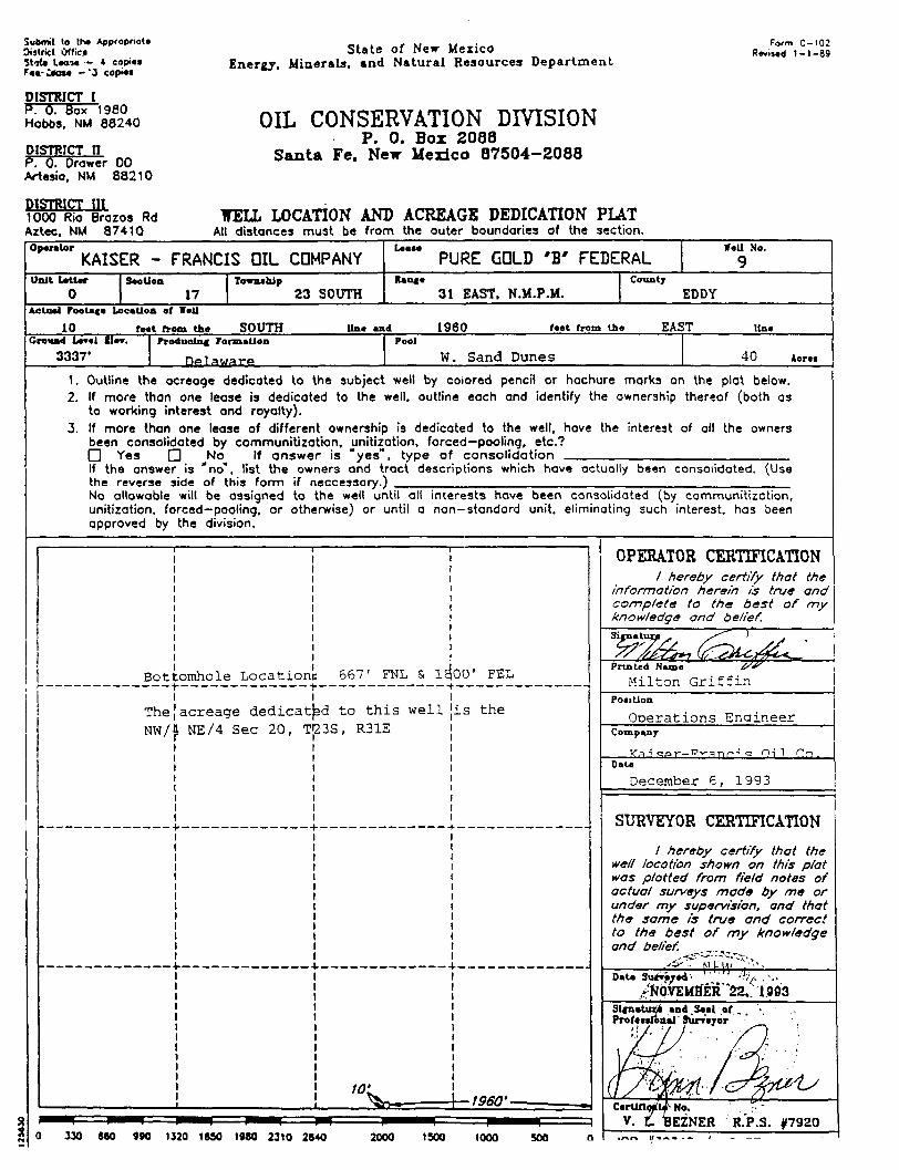
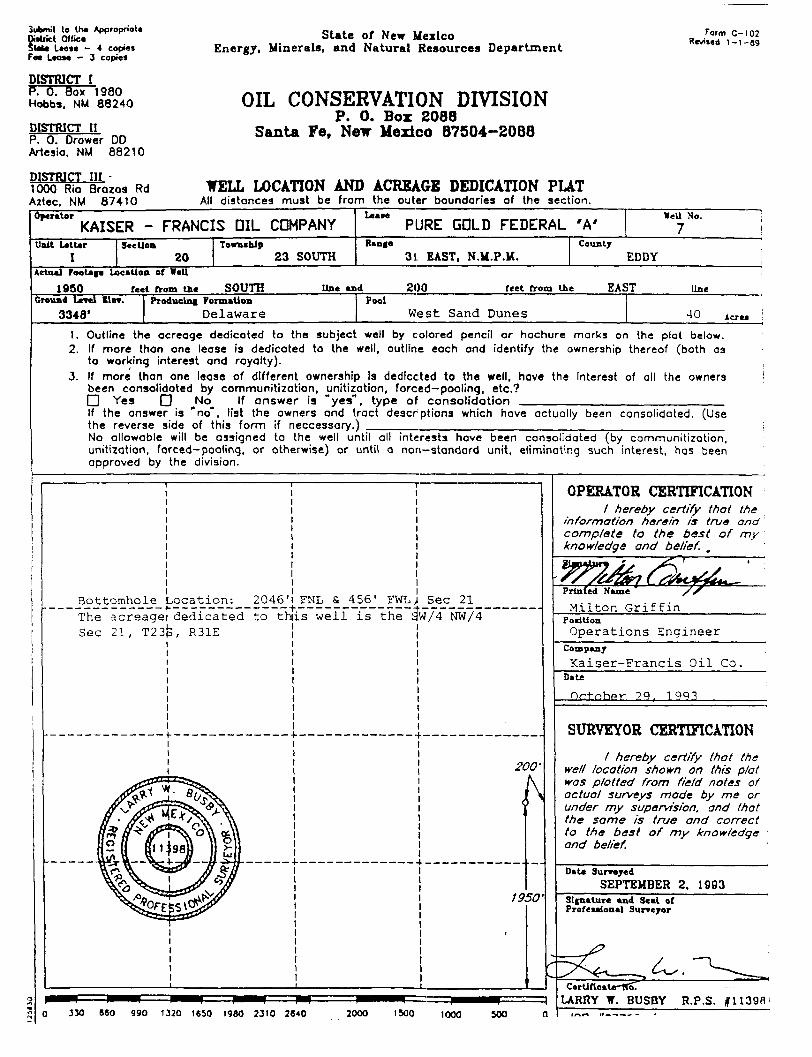
Submit lo I h * Appropriate District Office S t l i a I M M — * copies Fa t Cause - - 3 copies
DISTRICT I P. 0. Box 1980 Hobbs. NM 88240
D I S T R I C T n P. 0. Drower DO Artesia, NM 88210
DISTRICT III 1000 Rio Brazos Rd Aztec, NM 87410
State of Neir Mexico Energy. Minerals, and Natural Resources Department
OIL CONSERVATION DIVISION P. 0. Box 2088
Santa Fe, New Mexico 87504-2088
WELL LOCATION AND ACREAGE DEDICATION PLAT All distances must be f rom the outer boundaries of the section.
Form C-102 Revised 1 - 1 - 8 9
Opera to r
KAISER - FRANCIS OIL COMPANY Leaae
PURE GOLD ' B ' FEDERAL V e i l No.
9 Unit Letter
0 S e c t i o n
17 Township Ran^e
23 SOUTH 31 EAST, N.M.P.M. County
EDDY A c t u a l r*oota«e L o c a t i o n o f V e i l
10 feet from tho S O U T H line and 1 9 6 0 feet from the E A S T l i n e Ground Level Ele
3337* ProOjuelnf FormaUon
Delaware
Pool
W. Sand Dunes 40 Aorea
1. Outline the ocreoge dedicated to the subject well by colored pencil or hachure marks on the plat below. 2. If more than one lease is dedicated to the well, outline each and identify the ownership thereof (both as
to working interest and royalty).
3. If more than one lease of different ownership is dedicated to the well, have the interest of all the owners been consolidated by communi t izat ion, unit ization, forced—pooling, etc.? O Yes D No If a n s w e r is " y e s " , t ype of c o n s o l i d a t i o n If the answer is " n o " , list the owners ond tract descriptions which have octually been consolidated. (Use the reverse side of this fo rm if neccessary.) No allowable will be assigned to the well until all interests have been consolidated (by communi t izat ion, unitization, forced—pooling, or otherwise) or until a non—standord unit, eliminating such interest, has been approved by the division.
Bottomhole Location!: 667' FNL & 1^00' FEL
The|acreage dedicated to t h i s well m / \ NE/4 Sec 20, T|23S, R31E
i s the
0 330 680 990 1320 1650 1980 2310 2640 2000 1500 1000 500
OPERATOR CERTIFICATION / hereby certify that the
information herein is true and complete to the best of my knowledge and belief.
S i f n a t u ;
Printed Name ~27'
iMilton G r i f f i n PoeiUon
Operations Enaineer Company
< f J ^ 0 r - P r ^ T i r ; < : Oil r.n . DaU
December 6, 1993
SURVEYOR CERTIFICATION
/ hereby certify that the well location shown on this plat was plotted from field notes of actual surveys made by me or under my supervision, and that the same is true and correct to the best of my knowledge and belief.
Data 3utriyed- " "" •h/. .
,^0.VEMtfER"22,. 1993 Signature- and .Seal of . Professional (hirr'eyor
R.P.S. #7920
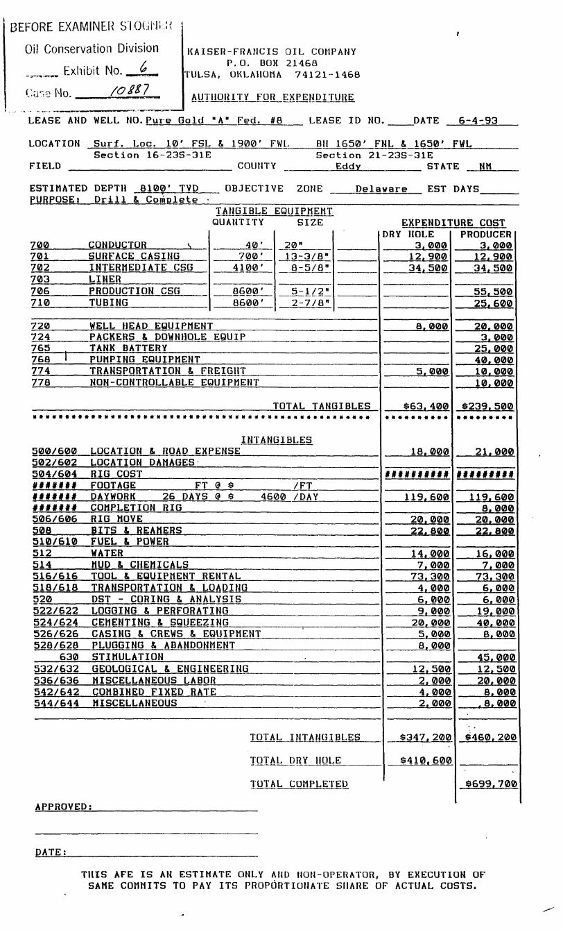
BEFORE EXAMINER S'lOGNIK
Oil Conservation Division
Exhibit No. _JL-
C.asQ Mo. /Q**7
KAISER-FRAHCIS OIL COMPANY P.O. BOX 21468
TULSA, OKLAHOMA 74121-1468
AUTHORITY FOR EXPENDITURE
LEASE AND WELL NO.Pure Gold Fed. #8 LEASE ID NO. DATE 6-4-93
LOCATION Surf. Loc. 10' FSL 8. 1900' FWL. Section 16-23S-31E
FIELD COUNTY
BH 1650' FNL 8. 1650' FWL Section 21-23S-31E
Eddy STATE NM
ESTIMATED DEPTH 8100' TVD PURPOSEi D r i l l 8. Complete
OBJECTIVE ZONE Delaware EST DAYS
TANGIBLE EQUIPMEMT QUANTITY SIZE EXPENDITURE COST
700 CONDUCTOR s 40' 20" DRY HOLE
3. 000 PRODUCER
3. 000 701 SURFACE CASING 700' 13-3/8" 12.900 12.900 702 INTERMEDIATE CSG 4100' 8-5/8" 34. 500 34, 500 703 LINER 706 PRODUCTION CSG 8600' 5-1/2" 55. 500 710 TUBING 8600' 2-7/8" 25, 600
720 WELL HEAD EQUIPMENT 8. 000 20. 000 724 PACKERS & DOWNHOLE EQUIP 3. 000 765 TANK BATTERY 25. 000 768 1 PUMPING EQUIPMENT 40,000 774 TRANSPORTATION & FREIGHT 5, 000 10.000 778 NON-CONTROLLABLE EQUIPMENT 10, 000
TOTAL TANGIBLES $63.400 $239.500
INTANGIBLES 500/600 LOCATION & ROAD EXPENSE
««*«*««««•
18.000
•«••*•«•«
21.000 502/602 LOCATION DAMAGES 504/604 RIG COST #######**# »*«##**## ####### FOOTAGE FT @ $ /FT ##«*«## DAYWORK 26 DAYS & $ 4600 /DAY 119.600 119.600 ##»»### COMPLETION RIG 8. 000 506/606 RIG MOVE 20.000 20,000 508 BITS 8. REAMERS 22.800 22. 800 510/610 FUEL 8, POWER 512 WATER 14.000 16.000 514 MUD & CHEMICALS 7. 000 7. 000 516/616 TOOL 8. EQUIPMENT RENTAL 73.300 73.300 518/618 TRANSPORTATION 8. LOADING 4. 000 6, 000 520 DST - CORING 8. ANALYSIS 6, 000 6, 000 522/622 LOGGING & PERFORATING 9. 000 19,000 524/624 CEMENTING & SQUEEZING 20,000 40,000 526/626 CASING 8. CREWS 8, EQUIPMENT 5. 000 8, 000 528/628 PLUGGING & ABANDONMENT 8, 000
630 STIMULATION 45,000 532/632 GEOLOGICAL 8. ENGINEERING 12.500 12,500 536/636 MISCELLANEOUS LABOR 2, 000 20,000 542/642 COMBINED FIXED RATE 4, 000 8. 000 544/644 MISCELLANEOUS 2. 000 , 8. 000
TOTAL INTANGIBLES $347.200 $460,200
TOTAL DRY HOLE $410.600
TOTAL COMPLETED $699.700
APPROVED;
DATE:
THIS AFE IS AN ESTIMATE ONLY AND NON-OPERATOR, BY EXECUTION OF SAME COMMITS TO PAY ITS PROPORTIONATE SHARE OF ACTUAL COSTS.

t
13-Dec-93 Interest
of: EVAL DRILLING PROPOSAL USE AVERAGE HELL
1,2,3-PETROLEUH EVALOATIOH as-of: 12.1993
Lease: PURE GOLD A & B LEASES Fid/Zone: SAND DUNES DELAWARE ST/Co: NM, EDDY Oper: KFOC
Oil,bbl Gas,HCF Legal: SEC 20 5 21 23S-31E WI NRI CU1= 0 0
Initial: 1.000000 0.840000 Res= 150928 873459 Life,yrs= 27.00 Final: 1.000000 0.84OOOO Dlt= 150928 873459 Reversion Point,yrs= 1.06
—Gross Reserves— —Net Reserves —Back Calc. Avq.— —Production Taxes- —Net Rev Post Tax-Yr Ends Oil,bbl Gas,HCF oil,bbl Gas,MCF Oil,$/bbl Gas,$/HCF Oil ($) Gas (S) Oil ($) Gas ($)
12.1993 5610 5610 4712 4712 14.14 1.790 4724 598 61909 7837
11.1994 49250 102879 41370 86418 14.41 1.856 42255 11371 553724 149015 11.1995 21240 80468 17842 67593 15.15 2.000 19164 9585 251137 125607 11.1996 12878 63246 10818 53126 15.92 2.161 12208 8138 159984 106643 11.1997 9779 56335 8214 47321 16.73 2.335 9742 7835 127657 102678 11.1998 7823 51628 6572 43368 17.56 2.522 8183 7754 107231 101609 11.1999 6259 46048 5257 38680 18.44 2.723 6874 7468 90074 97863 11.2000 5007 39061 4206 32811 19.38 2.943 5778 6845 75720 89702 11.2001 4405 37053 3700 31125 20.35 3.178 5337 7013 69943 91899 11.2002 3964 35635 3330 29933 21.36 3.432 5044 7284 66096 95451 11.2003 3568 34044 2997 28597 22.43 3.707 4766 7515 62460 98484 11.2004 3211 32330 2697 27157 23.55 4.003 4504 7708 59025 101010 11.2005 2890 30539 2428 25652 24.73 4.324 4256 7863 55779 103045 11.2006 2601 28707 2135 24114 25.97 4.669 4022 7983 52711 104614
Sub-Total 132875 637972 111615 535896 16.70 2.747 132135 104364 1731540 1367619 Retaining 18053 235487 15164 197809 35.16 7.352 37808 110118 495447 1443032
TOTAL 150928 373459 126779 733706 18.91 4.123 169942 214482 2226987 2810650
llet Rev. Ad Valorei Operating Future Net Capital Salvage —Net Cash Flow— -Discount § 8.001-Yr Ends Total (5) Taxes (?) Costs (?) Income (S) Costs ($) Costs ($) Annual Cuiulative Annual Cuiulative
12.1993 69746 1674 1500 66572 699700 0 -633128 -633128
11.1994 702739 16866 27389 658485 699700 0 -41215 -41215 -61520 -61520 11.1995 376744 9042 31825 335877 0 0 335877 294662 298840 237320 11.1996 266627 6399 33416 226811 0 0 226811 521473 186129 423450 11.1997 230335 5528 35087 189720 0 0 189720 711193 143531 566981 11.1998 208840 5012 36841 166987 0 0 166987 878179 116630 683611 11.1999 187937 4510 38683 144743 0 0 144743 1022923 93331 776942 11.2000 165421 3970 40614 120837 0 0 120837 1143760 71840 848782 11.2001 161842 3884 42644 115313 0 0 115313 1259073 63285 912067 11.2002 161546 3877 44777 112893 0 0 112893 1371965 57193 969261 11.2003 160945 3863 47015 110067 0 0 110067 1482032 51474 1020735 11.2004 160035 3841 49366 106828 0 0 106828 1588860 46119 1066854 11.2005 158824 3812 51835 103177 0 0 103177 1692037 41118 1107972 11.2006 157325 3776 54426 99123 0 0 99123 1791160 36465 1144437
Sab-Total 3099159 74380 533919 2490860 699700 0 1791160 1791160 1144437 1144437 Retaining 1938478 46523 1120015 771940 0 0 771940 771940 189077 189077
TOTAL 5037637 120903 1653934 3262800 699700 0 2563100 2563100 1333514 1333514
BEFORE EXAMINER STOGNER
Oil Conservation Division
Exhibit No. y
Case No. / c > e ^
Discounted Net Cash Flow § 10.00* 12.001 15.001 20.00*
75tPW8.00t
1166388 1029118 864412 663672 1000136
KAISER-FRANCIS OIL COMPANY APPLICATION FOR DIRECTIONAL DRILLING PERMITS
PURE GOLD WELL LOCATIONS
Well: Surface: BHL:
We l l : Surface: BHL:
Well: Surface: BHL:
We l l : Surface: BHL:
We l l : Surface: BHL :
W e l l : Surface: BHL:
We l l : Surface: BHL:
We l l : Surface: BHL:
We l l : Surface: BHL:
Well : Surface: BHL:
Pure Gold 1950' FSL 2043' FNL
Pure Gold 10' FSL
1947' FNL
Pure Gold 10' FSL
480' FNL
Pure Gold 10' FSL
480' FNL
Pure Gold 10' FSL
2012' FNL
Pure Gold 10' FSL
480' FNL
Pure Gold 2100' FSL 1988' FNL
A-7 x 200' x 456'
A-8 x 1935' x 1789'
A-9 x 280' x 480'
10 1800' 1800'
A-13 x 2025' x 2176'
14 2160' 2160'
B-7 x 1600' x 1834'
Pure Gold B-8 1950' FSL x 335'
FEL FWL
FWL FWL
FWL FWL
FWL FWL
FEL FEL
FEL FEL
FEL FEL
( U n i t (U n i *
( U n i t N ( U n i t F
( U n i t M ( U n i t K
( U n i t N ( U n i t C
( U n i t ( U n i t
( U n i t ( U n i t
( U n i t (Unit.
Pure Gold 10' FSL
480' FNL
Pure Gold 10' FSL
480' FNL
9 I960' 1800'
•10 145' 480'
FEL FEL
FWL FEL
(U n i t ( U n i t
( U n i t ( U n i t
FEL (Unit. I 1957' FNL x 505' FEL ( U n i t H
Sec 20 Sec 21
Sec 16 Sec 21
Sec 16 Sec 21
Sec 16 Sec 21
Sec 16 Sec 21
Sec 16 Sec 21
Sec 20 Sec 20
Sec 20 Sec 20
Sec 17 Sec 20
Sec 16 Sec 20

Form 3160-3 (December 1990) UNITED STATES
DEPARTMENT OF THE INTERIOR
SUBMIT IN n u r U C A T E * (Other lnatrurtlnne on
reieme tide)
Form epprofed. Budget Bureau No. 1004-0136 Expiree: December 31, I991
BUREAU OF LAND MANAGEMENT NM38464
APPLICATION FOR PERMIT TO DRILL OR DEEPEN 0. i r INDIAN, I L U I T H oa r a i a a m n
l a . T i r r o r WORK
DRILL E DEEPEN • b. T i n o r W E L L
o r t rTTl OAR I—I 81 NO u t r r n u m , T I T L E i—t WELL lAJ Vt ELL 1 1 OTHER IOHI l i U ZONE 1 1
0. i r INDIAN, I L U I T H oa r a i a a m n
l a . T i r r o r WORK
DRILL E DEEPEN • b. T i n o r W E L L
o r t rTTl OAR I—I 81 NO u t r r n u m , T I T L E i—t WELL lAJ Vt ELL 1 1 OTHER IOHI l i U ZONE 1 1
7. U N I T l o i i i H i i t i x a x a l a . T i r r o r WORK
DRILL E DEEPEN • b. T i n o r W E L L
o r t rTTl OAR I—I 81 NO u t r r n u m , T I T L E i—t WELL lAJ Vt ELL 1 1 OTHER IOHI l i U ZONE 1 1
8. tAMM 0» LAA91 HA*m. W t U . HO.
Pure Gold A Fede ra l 2 . K A M I o r o r E E A T O K
K a i s e r - F r a n c i s O i l Company
8. tAMM 0» LAA91 HA*m. W t U . HO.
Pure Gold A Fede ra l 2 . K A M I o r o r E E A T O K
K a i s e r - F r a n c i s O i l Company 9 . A J 1 H U L W
3. ACOtUXD TBUniOHBHO.
P.O. Box 21468, T u l s a , Oklahoma 74121-1468
9 . A J 1 H U L W
3. ACOtUXD TBUniOHBHO.
P.O. Box 21468, T u l s a , Oklahoma 74121-1468 1 0 . r i I L D AMD r o o t , o a WILDCAT
4. LOCATION or WELL (Report location clearly and In accordance wiLh any State requirements.*) At ntiriacr
1950' FSL & 200 ' FEL Sec 20 At propotfd prod, lone
"* 2046' FNT, fi 456' FWT, ,qpP 71 14. D I N T A N C I I N K I L I B A N D DiaicTiOH n o n K i i n i t T T O W N oa TOST o r r i c i *
17 miles East from Loving
0. L111B OHIONAIIOH A N D H I I A L NO.
West Sand Dunes 11. a i c . T_ i . , M „ oa I L L
AND e U l T E I oa 1111
Sec 21 , T23S, R31E 12. C O U N T I oa r A a i e n | 18. B T A T I
Eddv NM DIBTAHCI raou raorueto* LOCATION TO NCAICRT r i o r t a T r oa LEAN« r r . 4 5 6 ' (Al io to n ra r t i t drlg. unit Hot. If nny) 456 '
IS . DINTANi r r x o M r i to i -oacn L O C A T I O N * TO Kr.ARIST «CI.I. . rfRII.I.INO, COMrLCTID, -I r i / l l oa Arruni roa. on TJtii LIAH, rr. XDHU
10. NO. or Acias I N LKABB
feilQ 10. IKIU'OSCD DtTTI I
8100' TVD
17. NO. or Acaea ABSIONKD TO Tina WILL
40 20. ItOTAKI Ol CA1LI TOOLS
Rotary 21. iLlYA-nom (Show whether DF. RT. GR. ete.)
3348'
22. Arriox. O A T I w o n W I L L » T A I T *
PROPOSED CASINO AND CEMENTING PROGRAM
SIZE or noLE OfcADB. SinS OF CASHO WEIGHT vr.n rooT SCTTIXO D e m i q U A N T I T T o r C C M K N T
1 7 - 1 / 2 13 -3 /8 48# 700 700 sacks C i r c u l a t e d 8-5/8 32# 4070 1000 sacks C i r c u l a t e d
7 -7 /8 5-1/2 17# 8100' TVE 1370 sacks t i e back @ l e a s t ^ •, a 200' i n t o 8-5/8" Stage t o o l @ 6200'
1. I1IRU Rotary. 2. D r i l l 17-1/2" hole to 700' run & set 13-3/8" surface csg & cmt v/700 sx. 3. I n s t a l l 3000# BOP I t e s t to 600#. 4. D r i l l 11" hole to 4070', run & set 8-5/8" intermediate csg & cmt v/1000 sx. 5. Test csg to 1000#. 6. D r i l l 7-7/8" hole t o 8100' TVD & run e l e c t r i c logs. 7. I f hydrocarbons are indicated, run Si set 5-1/2" csg 9 TD v/stage c o l l a r at
6200' and cmt 1st stage w/580 sx & 2nd stage v/790 sx. 8. RDM0 rotary, i n s t a l l wellhead, run cement bond log, perforate and stimulate
f o r production.
IN ADOVE STACF. DC.SCRIOC rROTOSGD PROGRAM: If proposal I< lo deepen, jive d i d on preienl productive tone and propoted new productive lone. If propoial !• lo drill or drrpen directionally, give pertinent data on lub.urfnce Joeationt and measured and Irue vertical depthi. Give blowout preventer program. If any.
Tirt.r. O p e r a t i o n s Eng inee r 10 -29-93
[Thin sprier for Federal or State oITlec u»r)
rrrtMiT so. Ai i nni AL DAI r..
Application approval doe* not warrant or certify that Uie applicant holds legal or editable title to thaie n'glii in Uie lubjrct lease wliich would cnUUe Uie applicant to conduct operatic™ thereon.
CONDITIONS OP ArrROVAL, IP ANY:
ATrROVT.D HY TITLE DATE
*See Instruction! O n R«v«rsc Side
T ' . l l - I H M.c; C. p , r r | | n n l f l f l | _ n , . , [ , , . r it <-rtmr. f « r nnv r - r r n n 1- ' i f w I n (';lV arif l " M l l f n l l y 1 mat. . . \ n n , y y , \ r p nr t -r"- M I nr np/*n'*T n f , , ! "
PLAT SHOWING PROPOSED WELL LOCATION AND LEASE ROAD IN SECTION 20, T-23-S, R-31-E, N.M.P.M. EDDY COUNTY, NEW MEXICO
K x l i l h l t F:
KaiBer-Francla O i l Co. Pure Gold "A" Fed. 17 liddy County, NR
18
19
I I*
Ik
rNO. BRA.
19
<7r
w 1 7 (EAST - O LO. - J833 73 ) 1' (N tise ie' e - ut*s. - z&Js w)
(EAST - CLO. - 2BJJ7J-) 17 (S ti-SSW I - UCfS. - 26J2.44) ' '
20
1950 KAISER-FRANCIS OIL COMPANY PURE GOLD FEDERAL "A' /7 GROUND ELEVATION : 3348'
20
29
P L A N VIEW I " = lOOO'
(WEST - CLO. - 5261.44 )
5J5-
29
21
28
5J5'
PROPOSED WEU LOCATION ELEV. : 3348'
DETAIL. VIE>T X" = l O O '
KAISER - FRANCIS OIL COMPANY ODESSA, TEXAS
SCALE: AS SHOWN KAISER - FRANCIS OIL COMPANY ODESSA, TEXAS
OATE: SEPTEMBER 2, 199J NO. REVISION OATE BY
KAISER - FRANCIS OIL COMPANY ODESSA, TEXAS JOB NO.: 97700
SURVEYED BY: R.J.O. SURVEYING ANO MAPPING BY
TOPOGRAPHIC LAND SURVEYORS A/IO/yWO, TEXAS
•18 SE ORAWN BY: V.H.B.
SURVEYING ANO MAPPING BY
TOPOGRAPHIC LAND SURVEYORS A/IO/yWO, TEXAS
•18 SE APPROVED BY: L.W.8.
SURVEYING ANO MAPPING BY
TOPOGRAPHIC LAND SURVEYORS A/IO/yWO, TEXAS SHEET : 1 OF 1
o CJ <• —1 t
•a a cu
u. ca 2
•H
• u
•< c V >. ro + J
<: u TJ C U. —( 3
i O 0
u a CJ j a OJ
tn OJ •H u TJ ro 3 TJ
Ul a. UJ
> - -
UJ
_ - _ _ L O T
- o t o
ro ! -•Oo
-»r-o_
- _ 0 -
CM -LO -
- N - _
<.. I
C3
j e u -L i - —
o * - o o O • fO o in i
-JTVJ--— q in in o > CM O H n i :
N i Lu
00 > : - - CO o o oo • ro O CO LO j
—l-«_LD—»— 00 LO CO O
LO O
r 1 .;
1 ; i 1; , r a » • , 1 LJ o o o ao LU CO 00 a \ " o * - t o o o CO N . S - ro ! < • LU ff . t ! * a ! • * »
. ! - . _ Ll— o _.ca O - a . LO -in i t *
! <^ LO m ro LO a ro 00 -* ! 13 O) < CD r— a: CM CM
i w .— C\J .— Q_ ro •— r— CM
- U i a i
Submit lo lha Appropriole District Offica Stat* L H M - 4 copies Fee Lease - 3 copies
DISTRICT I P. 0. Box 1980 Hobbs, NM 88240
DISTRICT H P. 0. Drower DD Artesio. NM 88210
State of New Mexico Energy, Minerals, and Natural Resources Department
OIL CONSERVATION DIVISION P. 0. Box 2088
Santa Fe, New Mexico 87504-2088
Form C-102 Reviled 1-1-89
DISTRICT III -1000 Rio Brozos Rd Aztec. NM 87410
WELL LOCATION AND ACREAGE DEDICATION PLAT All distances must be from the outer boundaries of the section.
Operator
KAISER - FRANCIS DIL CDMPANY PURE GOLD FEDERAL 'A' WeU No.
7 Unit Letter
I Section
20 Township
23 SOUTH Ranfe
31. EAST, N.M.P.M. County
EDDY Actual rootage Location of WeU
1 9 5 0 feel from the S O U T H line and 200 feet from the EAST line Ground Lerel lie*. Producing Formation Pool
3348' Delaware West Sand Dunes 40 icres
1. Outline the acreaqe dedicated to the subject well by colored pencil or hachure marks on the plat below. 2. If more than one lease is dedicated to the well, outline each and identify the ownership thereof (both as
to working interest and royalty). 3. If more than one lease of different ownership Is dedlccted to the well, hove the Interest of all the owners
been consolidated by communitization, unitization, forced—pooling, etc.? • Yes D No If answer is "yes", type of consolidation If the answer is 'no*, list the owners and tract descrptions which have actually been consolidated. (Use the reverse side of this form if neccessory.) No allowable will be assigned to the well until all interests hove been consolidated (by communitization, unitization, forced-pooling, or otherwise) or until a non—standard unit, eliminating such interest, has been approved by the division.
Bottomhole L o c a t i o n 2046' The acreagei dedicated to t h i i Sec 21, T23p, R31E
s w e l l i s the s!l Sec 21_
w74~NW/4'
200
1950
OPERATOR CERTIFICATION / hereby certify that the
information herein is true and complete to the best of my knowledge and belief. ,
o ;—:
Printed Name
M i l t o n G r i f f i n Position
Operations Engineer Company
Kaiser-Francis O i l Co. Date
O r . t n b p r ? q , 1 Q Q ?
330 880 990 1320 1650 1980 2310 2640 2000 1500 1000 500
SURVEYOR CERTIFICATION
/ hereby certify that the well location shown on this plat was plotted from field notes of actual surveys made by me or under my supervision, and that the same is true and correct to the best of my knowledge and belief.
Dile Surra-red
SEPTEMBER 2, 1993 Signature end Seal of Professional Surveyor
6^. Certlflcate-HoT
LARRY W. BUSBY R.P.S. #11396' fl 1 i r- t f - i " — — — - -
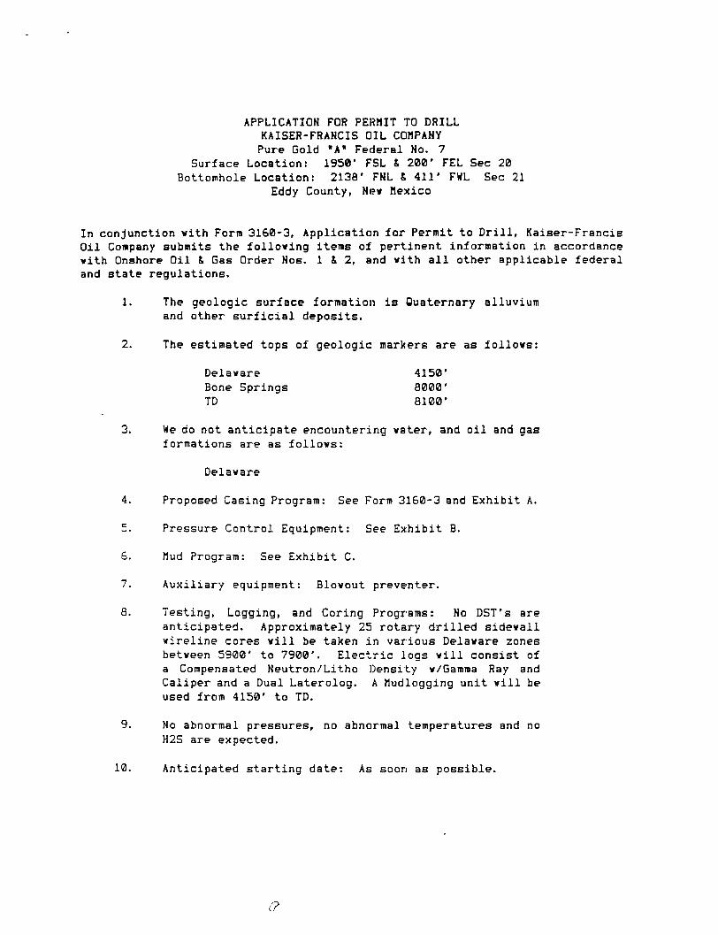
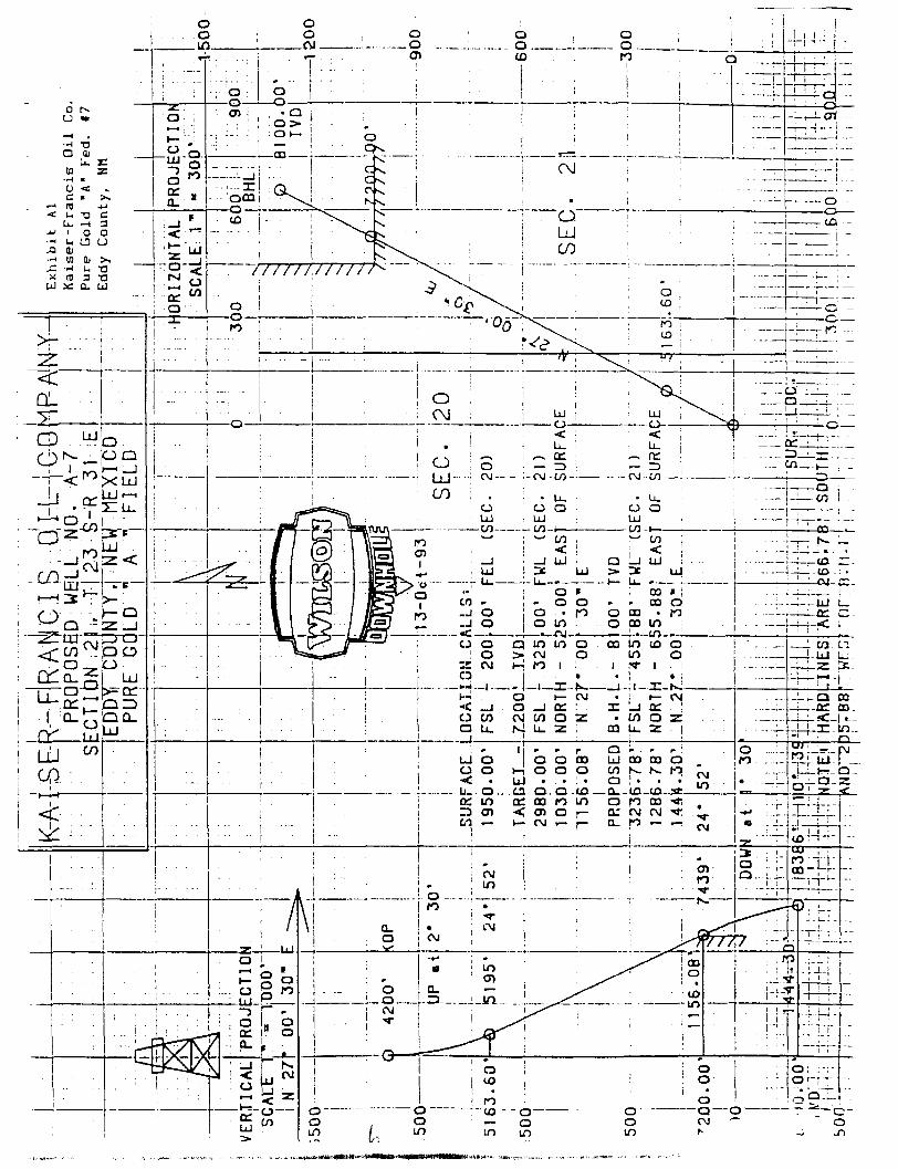
APPLICATION FOR PERMIT TO DRILL KAISER-FRANCIS OIL COMPANY Pure Gold "A* Federal No. 7
Surface Location: 1950' FSL & 200' FEL Sec 20 Bottomhole Location: 2138' FNL & 411' FWL Sec 21
Eddy County, Nev Mexico
In conjunction with Form 3160-3, Application for Permit to D r i l l , Kaiser-Francis Oil Company submits the following items of pertinent information in accordance with Onshore Oil & Gas Order Nos. 1 1 2 , and with a l l other applicable federal and state regulations.
1. The geologic surface formation i s Quaternary alluvium and other s u r f i c i a l deposits.
2. The estimated tops of geologic markers are as follows:
Delaware 4150' Bone Springs 8000' TD 8100'
3. We do not anticipate encountering water, and o i l and gas formations are as follows:
Delaware
4. Proposed Casing Program: See Form 3160-3 and Exhibit A.
5. Pressure Control Equipment: See Exhibit B.
6. Mud Program: See Exhibit C.
7. Auxiliary equipment: Blowout preventer.
fi. Testing, Logging, and Coring Programs: No DST's are anticipated. Approximately 25 rotary d r i l l e d sidewall wireline cores w i l l be taken i n various Delaware zones between 5900' to 7900'. Electric logs w i l l consist of a Compensated Neutron/Litho Density w/Gamma Ray and Caliper and a Dual Laterolog. A Mudlogging unit w i l l be used from 4150' to TD.
9. No abnormal pressures, no abnormal temperatures and no H2S are expected.
10. Anticipated star t i n g date: As soon as possible.
(?
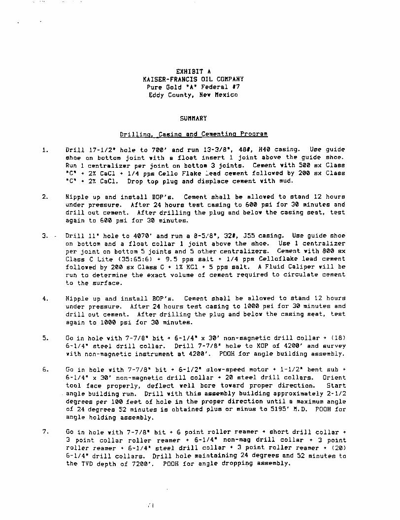
EXHIBIT A KAISER-FRANCIS OIL COMPANY Pure Gold "A" Federal 97 Eddy County, Nev Mexico
SUMMARY
D r i l l i n g , Casing and Cementing Program
1. D r i l l 17-1/2* hole to 700' and run 13-3/8", 48#, H40 casing. Use guide shoe on bottom j o i n t v i t h a f l o a t insert 1 j o i n t above the guide shoe. Run 1 centralizer per j o i n t on bottom 3 j o i n t s . Cement v i t h 500 sx Class "C» + 21. CaCl • 1/4 pps Cello Flake lead cement folloved by 200 sx Class "C" • Tt. CaCl. Drop top plug and displace cement v i t h mud.
2. Nipple up and i n s t a l l BOP's. Cement shall be alloved to stand 12 hours under pressure. After 24 hours test casing to 600 psi for 30 minutes and d r i l l out cement. After d r i l l i n g the plug and belov the casing seat, test again to 600 psi for 30 minutes.
3. - D r i l l 11" hole to 4070' and run a 8-5/8", 32#, J55 casing. Use guide shoe on bottom and a f l o a t c o l l a r 1 j o i n t above the shoe. Use 1 centralizer per j o i n t on bottom 5 j o i n t s and 5 other centralizers. Cement v i t h 800 sx Class C Li t e (35:65:6) +9.5 pps sa l t + 1/4 pps Celloflake lead cement folloved by 200 sx Class C + IX KC1 + 5 pps s a l t . A Fluid Caliper v i l l be run to determine the exact volume of cement required to circulate cement to the surface.
4. Nipple up and i n s t a l l BOP's. Cement shall be alloved to stand 12 hours under pressure. After 24 hours test casing to 1000 psi for 30 minutes and d r i l l out cement. After d r i l l i n g the plug and belov the casing seat, test again to 1000 psi for 30 minutes.
5. Go in hole v i t h 7-7/8" b i t + 6-1/4" x 30' non-magnetic d r i l l c o l l a r • (18) 6-1/4" steel d r i l l c ollar. D r i l l 7-7/8" hole to KOP of 4200' and survey v i t h non-magnetic instrument at 4200'. POOH f o r angle building assembly.
6. Go in hole v i t h 7-7/8" b i t + 6-1/2* slov-speed motor + 1-1/2" bent sub • 6-1/4" x 30' non-magnetic d r i l l c o l l a r + 20 steel d r i l l collars. Orient tool face properly, deflect v e i l bore tovard proper direction. Start angle building run. D r i l l v i t h t h i s assembly building approximately 2-1/2 degrees per 100 feet of hole i n the proper direction u n t i l a maximum angle of 24 degrees 52 minutes i s obtained plus or minus to 5195' M.D. POOH for angle holding assembly.
7. Go in hole v i t h 7-7/8" b i t + 6 point r o l l e r reamer • short d r i l l c o l l a r • 3 point c o l l a r r o l l e r reamer + 6-1/4" non-mag d r i l l c o l l a r + 3 point r o l l e r reamer + 6-1/4" steel d r i l l c o l l a r • 3 point r o l l e r reamer + (20) 6-1/4" d r i l l c ollars. D r i l l hole maintaining 24 degrees and 52 minutes to the TVD depth of 7200'. POOH for angle dropping assembly.
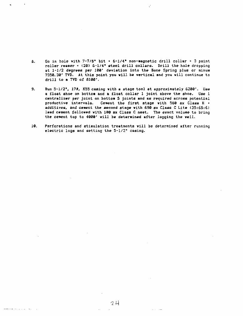
n
Go in hole vith 7-7/8" bit • 6-1/4" non-magnetic d r i l l collar • 3 point roller reamer • (20) 6-1/4" steel d r i l l collars. D r i l l the hole dropping at 1-1/2 degrees per 100' deviation to plugs or minus 7200' TVD. At this point you v i l l continue to d r i l l to a TVD depth of 8100'.
Run 5-1/2", 17#, K55 casing vith a stage tool at approximately 6200*. Use a float shoe on bottom and a float collar 1 joint above the shoe. Use 1 centralizer per joint on bottom 5 joints and as required across potential productive intervals. Cement the f i r s t stage vith 580 sx Class H + additives, and cement the second stage vith 690 sx Class C Lite (35:65:6) lead cement folloved vith 100 sx Class C neat. The exact volume to bring the cement top to 4000' v i l l be determined after logging the veil.
Perforations and stimulation treatments v i l l be determined after running electric logs and setting the 5-1/2" casing.
Torm 31«0 3 (December 1990) UNITED STATES
DEPARTMENT OF THE INTERIOR
SUDHTT I N T R I P L I C A T E '
tOttitr Inntnjf l lont en r tr trae aide)
r o r m approved .
Budnet D u r c a u No. 1 0 0 4 - 0 1 3 6
E x p i r e e : D e c e m b e r 31, 1991
BUREAU OF LAND MANAGEMENT NM38464
APPLICATION FOR PERMIT TO DRILL OR DEEPEN Q. j r I N D I A N , ALLOTTBB 0 1 T B I B B B l a t B
1 * . T T r u o r W O I K
DRILL S3 DEEPEN • k. t i n o r W E L L
O I L r ^ i m a i—t a ine i .a TT71 m t i .T t r LB [—l W I L L IA1 w i n . 1 1 O T n n t o n e u U l o a i 1 1
Q. j r I N D I A N , ALLOTTBB 0 1 T B I B B B l a t B
1 * . T T r u o r W O I K
DRILL S3 DEEPEN • k. t i n o r W E L L
O I L r ^ i m a i—t a ine i .a TT71 m t i .T t r LB [—l W I L L IA1 w i n . 1 1 O T n n t o n e u U l o a i 1 1
1 * . T T r u o r W O I K
DRILL S3 DEEPEN • k. t i n o r W E L L
O I L r ^ i m a i—t a ine i .a TT71 m t i .T t r LB [—l W I L L IA1 w i n . 1 1 O T n n t o n e u U l o a i 1 1 8. rAaju oa LBASR MAMO. w n x HO.
Pure Go ld A F e d e r a l 3. n i m o r o r t a a r o a
K a i s e r - F r a n c i s O i l Company
8. rAaju oa LBASR MAMO. w n x HO.
Pure Go ld A F e d e r a l 3. n i m o r o r t a a r o a
K a i s e r - F r a n c i s O i l Company 9. M i w a x m .
8 3 . AOOUSKS A / O TTLBTtlOHe MO.
P.O. Box 21468, T u l s a , Oklahoma 74121-1468
9. M i w a x m .
8 3 . AOOUSKS A / O TTLBTtlOHe MO.
P.O. Box 21468, T u l s a , Oklahoma 74121-1468 10. r i i L o A N D r o o L , oa W I L D C A T
4. L O C A T I O N o r W I L L (Report location d c i i i r and la Accordtoct with any 8 U t t requirement*-.*) At - a t i r f ,
10' F S L S 1935' FWL Sec 16 At propoeed prod. ieae
1947' FNL S, 1789' FWL Sec 21 14. D I N T A K C I in MiLle AHO Diaacr ion n o n XBAaiaT T O W N oa r u a r o r r i c a *
17 miles East from Loving lo. DINTANCI rioM rioruaco'
LOCATION TO NCAH1T 1 7 8 9 '
rtoriarr oa LEABI tint, rr.
West Sand Dunes 11. I I C . T.. a.. M_, 01 BL«.
AHO a u a r a r oa A B B A
Sec 21, T23S , R31E 12. C O U N T I oa r a a i a n
( A l i o to Bearcat dr l f . unit Hot. If any) ' 4 6 9 ' I s . DtaTAix'n r i o M r a o r o a t n L O C A T I O N *
TO ietAB«»T WCt.U n l l L L i f u , COJtrLlTID. oa A r r u n roa. on Tnis U A H . r r . 2 2 5 0
10. NO. or J C I I I I N L c a a c
_ ID . r a o r o a c o o c r r n
8100" TVD
Eddy
13. BTATt
NM 17. No. or ACBBN AaalQNBD
TO Til 18 WILL
40 20. lOTABI 01 CAB LB T00L8
Rotary 21. I L I T A T I O M B (Shew whether O F . R T , GR. e t c ! 22. Arraox. D A T B W O I K . W I L L B T A B T *
2.1. P R O P O S E D C A S I N O AND C E M S N T 1 N Q P R O G R A M
ai t i or nobs ortAoa. sta or CASIHQ WKIOIIT rr.n TOOT a f T T I M O D B l - T I I QUANT1TT O r C I M B N T
17-1/2 13-3/8 4 8 ft 700 700 sacks Circulated 11 8-5/8 32# 4070 1000 sacks Circulated
7-7/8 5-1/2 17# 8100' TVC 1370 sacks t i e back @ least
1. 2. 3. 4. 5. 6. 7.
^ , a r - r - r y , 2 0 0 ' i n t ° 8 - 5 / 8 "
Stage tool @ 6200' MIRU Rotary. D r i l l 17-1/2" hole to 700' run & set 13-3/8" surface csg k cmt v/700 sx. I n s t a l l 3000# BOP & test to 600#. D r i l l 11" hole to 4070', run & set 8-5/8" intermediate csg 4 cmt v/1000 sx. Test csg to 1000**. D r i l l 7-7/8" hole to 8100' TVD & run elect r i c logs. I f hydrocarbons are indicated, run & set 5-1/2" csg 9 TD w/stage COIIBT at 6200' and cmt 1st stage w/580 sx & 2nd stage v/790 sx. RDM0 rotary, i n s t a l l wellhead, run cement bond log, perforate and stimulate for production.
IN A I l O V C S P A C n D E S C R I B E PROPOSED r l tOGRAM: If propwal >• lo deepen give data on preient productive lone and proposed new productive tone. If propoial l« lo drill or deepen dircctlonilly, give pertinent data on iuV>iu*{nce location* and measured and true verticil dentin. Give blowout preventer progiam, II any.
TtTt.r O p e r a t i o n s Enrj in f>sr DAT« 1 0 - 2 9 - 9 3
(Thin »p«ce for Federal or State office u»r)
AITItrjV Al. OATR .
Application approval doea not warrant or cero'Ty llinl die applicant lloldf legal or equitable Ulle to lltcee rigllti In tlie tubjret lease which would entitle die applicant to conilucl operations thereon.
COHDITIONS Of ArrHOVAL. IF AMY:
Arr«ovtoor. TITLE . DATE
[,- *S«e Irultuctiorti On Rttverie Side
Tin- i " n.s.r. r>riim, mm ~-L.
WELL LOCATION AND LEASE ROAD IN SECTION 16 ic 21, T - 2 3 - S , R - 3 1 - E , N.M.P.M. EDDY COUNTY, NEW MEXICO
h;i i I i n i " ' l •' 1 H I I '>•
Pure Gold *A' Fed. f8 Eddy County, NH
P L A N V I E W 1" = l O O O '
(Wtst - CLO. - 52:11.3J )
(N srsrvr w - UCAS. - atsjo-i
535-
Slits CAP 27'(nrKMj
- N -
200-
SCOIOH LIHC PROPOSED
200-
WELL LOCATION ELEV. : 3363'
^Z7
£ PtfCPQSfD UASt: ROW
D E T A I L VIETT 1" = l O O '
535' gumco ptmjNc-
KAISER-FRANCIS OIL COMPANY ODESSA, TEXAS
SCALE: AS SHOWN KAISER-FRANCIS OIL COMPANY ODESSA, TEXAS
OATE: SEPTEMBER 3. 1993 NO. REVISION OATE BY
KAISER-FRANCIS OIL COMPANY ODESSA, TEXAS JOB NO.: 97706
SURVEYED BY: R.J.O. SURVEYING ANO MAPPING BY
TOPOGRAPHIC LAND SURVEYORS MIDLAND, TEXAS
48 SE DRAWN BY: V.H.B.
SURVEYING ANO MAPPING BY
TOPOGRAPHIC LAND SURVEYORS MIDLAND, TEXAS
48 SE APPROVEO BY: L.W.B.
SURVEYING ANO MAPPING BY
TOPOGRAPHIC LAND SURVEYORS MIDLAND, TEXAS SHEET : 1 OF 1
\ X
PROJECTION
obo'
— 1 H <"*
•OC
ON . 2
Submt te lt*» *opfopr io l« Di . i r ie l Ottice Stote Leoee - 1 eopi«;» T— Leoee - 3 copiet
DISTRICT I P. 0 . Box 1980 Hobbs. NM 88240
DISTRICT II P. O. Drawer DO Artesio, NM 88210
Stale of New Mexico Energy, Minerals, and Natural Resources Department
OIL CONSERVATION DIVISION P. 0. Box 2088
Santa Fe, New Mexico 87504-2088
F 0 r r n
DISTRICT PI 1000 Rio Brozos Rd Aztec. NM 87410
WELL LOCATION AND ACREAGE DEDICATION PLAT AM distances must be f rom the outer boundaries of the section.
Operator
KAISER - FRANCIS OIL CDMPANY Let.ee
P U R E G O L D " H " F E D E R A L WeU Ho.
8 Unit Utter
N SeeUoB
16 Townehip
23 SOUTH Range
31 EAST, N.M.P.H. County
EDDY Actual Footage Location of WeU
10 feel from the S O U T H Une and 1935 feet from Lhe WEST line Ground La-eel Iter. Produeinc Formation Pool
3369' Delaware W€>st Sand Dunes an lcret
1. Outline the acreage dedicated to the subject well by colored pencil or hachure marks on the plot beiow. 2. If more than one lease is dedicated to the well, outline each ond identify the ownership thereof (both os
to working interest ond royal ty) .
3. If more than one lease of dif ferent ownership is dedicated to the well, have the interest of all the owners been consolidated by communi t iza t ion , unit izat ion, forced—pooling, etc.? Q Yes 0 No If a n s w e r is " y e s " , t ype of c o n s o l i d a t i o n If the answer is " n o " , list the owners ond tract descriptions which have actually been consolidated. (Use the reverse side of this f o rm if neccessory.) No ollowoble will be ossigned to the well until all interests have been consolidated (by communi t izat ion, unit ization, fo rced-poo l ing , or otherwise) or until a non-s tandard unit, eliminating such interest, has been approved by the division.
Bottcm'riale Locat ion: ^947' The acreage i s dedicated to SE/4 NW/4 Sec 21,T23S,i31E
FNL & 1789, FWL Sec 21 th i s l e a s e i i s the
w •1935'-
OPERATOR CERTIFICATION / hereby certify that the
information herein is true arc complete to the best of my knowledge and belief.
Printed Name / /
l i l t c n G r i f f i n PoeiUon
Operations Encinee: Company
Kaiser-Francis Oil
330 S60 990 1320 1650 1980 2310 26<0 2000 1500 100Q 500
DaLe
Ocrnher ? Q . i Q Q '
SURVEYOR (TERTLFICATION
/ hereby certify that the well location shown on this p/ar was plotted from field notes cf actual surveys made by me or under my supervision, and that the same is true ond correct to the best of my knowledge and belief.
Dale Surveyed
SEPTEMBER 3, 1993 Signature and Seal of Profeiaional Surveyor
C e r t l f l c a U J t a * '
I T BU LARRY BUSBY P. ^ JOB »'q77ns;
APPLICATION FOR PERMIT TO DRILL KAISER-FRANCIS OIL COMPANY Pure Gold "A* Federal No. 8
Surface Location: 10' FSL. & 1935' FWL Sec 16 Bottomhole Location: 1947' FNL & 1789' FWL Sec 21
Eddy County, Ne* Mexico
In conjunction with Form 3160-3, Application for Permit to D r i l l , Kaiser-Francis • i l Company submits the following items of pertinent information in accordance v i t h Onshore Oil & Gas Order Nos. 1 & 2, and v i t h a l l other applicable federal and state regulations.
1. The geologic surface formation i s Quaternary alluvium and other s u r f i c i a l deposits.
2. The estimated tops of geologic markers are as follows:
Delaware 4150' Bone Springs 8000' TD 8100'
3. We do not anticipate encountering vater, and o i l and gas formations are as follows:
Delaware
4. Proposed Casing Program: See Form 3160-3 and Exhibit A.
5. Pressure Control Equipment: See Exhibit B.
6. Mud Program: See Exhibit C.
7. Auxiliary equipment: Blowout preventer.
8. Testing, Logging, and Coring Programs: No DST's are anticipated. Approximately 25 rotary d r i l l e d sidewall wireline cores w i l l be taken i n various Delaware zones between 5900' to 7900'. Ele c t r i c logs w i l l consist of a Compensated Neutron/Litho Density w/Gamma Ray and Caliper and a Dual Laterolog. A Mudlogging unit w i l l be used from 4150' to TD.
9. No abnormal pressures, no abnormal temperatures and no H2S are expected.
10. Anticipated s t a r t i n g date: As soon as possible.
EXHIBIT A KAISER-FRANCIS OIL COMPANY Pure Gold "A" Federal #8 Eddy County, New Mexico
SUMMARY
D r i l l i n g . Casing and Cementing Program
1. D r i l l 17-1/2" hole to 700' and run 13-3/8", 48#, H40 casing. Use guide shoe on bottom j o i n t with a f l o a t insert 1 j o i n t above the guide shoe. Run 1 centralizer per j o i n t on bottom 3 jo i n t s . Cement with 500 sx Class "C" • 27. CaCl * 1/4 pps Cello Flake lead cement followed by 200 sx Class "C" • 21. CaCl. Drop top plug and displace cement with mud.
2. Nipple up and i n s t a l l BOP's. Cement shall be allowed to stand 12 hours under pressure. After 24 hours test casing to 600 psi for 30 minutes and d r i l l out cement. After d r i l l i n g the plug and below the casing seat, test again to 600 psi for 30 minutes.
3. D r i l l 11" hole to 4070' and run a 8-5/8", 321, J55 casing. Use guide shoe on bottom and a f l o a t c o l l a r 1 j o i n t above the shoe. Use 1 centralizer per j o i n t on bottom 5 j o i n t s and 5 other centralizers. Cement with 800 sx Class C Lite (35:65:6) + 9.5 pps s a l t + 1/4 pps Celloflake lead cement followed by 200 sx Class C + IX KC1 • 5 pps sal t . A Fluid Caliper w i l l be run to determine the exact volume of cement required to circulate cement to the surface.
4. Nipple up and i n s t a l l BOP's. Cement, shall be allowed to stand 12 hours under pressure. After 24 hours test casing to 1000 psi for 30 minutes and d r i l l out cement. After d r i l l i n g the plug and below the casing seat, test again to 1000 psi for 30 minutes.
5. Go in hole with 7-7/8" b i t + 6-1/4" x 30' non-magnetic d r i l l c o l l a r + (18) 6-1/4" steel d r i l l c o l l a r . D r i l l 7-7/8" hole to KOP of 4200' and survey with non-magnetic instrument at 4200'. POOH for angle building assembly.
6. Go in hole with 7-7/8" b i t + 6-1/2" slow-speed motor + 1-1/2" bent sub + 6-1/4" x 30' non-magnetic d r i l l c o l l a r • steel d r i l l collars. Orient tool face properly, deflect well bore toward proper direction. Start angle building run. D r i l l with t h i s assembly building approximately 2-1/2 degrees per 100 feet of hole i n the proper direction u n t i l a maximum angle of 30 degrees 44 minutes i s obtained plus or minus to 5399' M.D. POOH for packed hole assemhly.
7. Go in hole with 7-7/8" b i t • 6 point r o l l e r reamer • short d r i l l c o l l a r • 3 point c o l l a r r o l l e r reamer • 6-1/4" non-mag d r i l l c o l l a r • 3 point r o l l e r reamer + 6-1/4" steel d r i l l c o l l a r * 3 point r o l l e r reamer • (20) 6-1/4" d r i l l c ollars. D r i l l hole maintaining 30 degrees 44 minutes deviation into the Bone Springs plus or minus 7600' TVD and continue to d r i l l to TD with the same deviation to plus or minus 8100' TVD.
8. Run 5-1/2", 17#, K55 casing v i t h a stage tool at approximately 6200'. Use a f l o a t shoe on bottom and a f l o a t collar 1 j o i n t above the shoe. Use 1 centralizer per j o i n t on bottom 5 j o i n t s and as required across potential productive intervals. Cement the f i r s t stage v i t h 580 sx Class H + additives, and cement the second stage v i t h 690 sx Class C Lite (35:65:6) lead cement folloved v i t h 100 sx Class C neat. The exact volume to bring the cement top to 4000' v i l l be determined after logging the v e i l .
9. Perforations and stimulation treatments v i l l be determined after running el e c t r i c logs and setting the 5-1/2' casing.
a
Fotm 3160-3
(December 1990) UNITED STATES
DEPARTMENT OF THE INTERIOR BUREAU OF LAND MANAGEMENT
SUBMIT IN TRIPLICATE* (Other I ne l r t j r t l oa t on
r t T f f M f t d e )
Form approved. Budfet Bureau No. 1004-0136 Expiree: December 31, 1991
APPLICATION FOR PERMIT TO DRILL OR DEEPEN l a . T i n o r w o n *
k. r r r i o r W I L L
WILL H
DRILL SJ DEEPEN •
ELL Q OA K I L L
a i r t e i . i t t o r i
u i i L n r L i | — I ZONK L _ l
2. > i a i o r oraaAToa
Kaiaer-Francis O i l Company 3. Acnaaa>M«nkanioMHO.
P.O. Box 21468, T u l s a , Oklahoma 74121-1468 4. L o c i T i o n o r n i l ( I lepor t locat laa d e a r l y and l a accordance w i t h a n ; Sta te requl remeate.* )
A t aur.ace ,
10 ' FSL & 280' FWL Sec 16 At proposed prod, lone
480' FNL £ 480 ' FWL Sec 21 14. DiaTANCa in MiLaa AND o iaac r ioH r a o x K I I I I I T « » « oa r o a r o r r i c x *
17 miles East from Loving
NM38464 0. ir IMBU,, ALLOTTX
1 . UNIT 1 0 1
8. FAAM oa LAvxaa MAMO. W B U . HO.
Pure Gold A Federa l » . M lwaLLHO.
10. riai-o AHO root, oa WILDCAT
West Sand Dunes 1 1 . e e c T » a., * „ oa B L * .
S e c 2 1 , T 2 3 S , R 3 1 E 12. C O U N T I aa r t a i a n
480 ' 10. oiaTAHce r a o u rao roaco*
LOCATION TO HCAatBT r i o i i u i oa Leaae L ine , r r . (Alee to a e a r e e t d r l f . un i t l loe. If a n r i 480 '
13. O I I T A H C C r«0M rao roaco L O C A T I O H * TO KCAacar r t a . O H I L L I . T J . c o u r L S T i o . oa A r r u o roa, en True U L U B . r r . 1120 '
18. NO. o r i c i c a IH L I A S !
640
Eddy
I S . e T A T I
NM
10. r ao roaco o c m i
8100' TVD
17 . n o . o r ACla. l t A l l l O l t l p TO T i l l * W I L L
40 20. aoTAar oa CABLB TOOLB
Rotarv 21. •LaiATiena (Show whether OF. RT. Git. etc.)
3354'
2 2 . A r r a o x . D A T B w o a a W I L L , B T A B T *
2 3 . P R O P O S E D C A S I N O A N O C E M E N T I N G P R O G R A M
a m o r H O L X WTC1011T P M TOOT » X T T I S O D K r r u QUAHT1T1 o r C X M I H T
17-1 /2 13-3 /8 48# 700 700 sacks C i r c u l a t e d 11 8-5/8 32# 4070 1000 sacks C i r c u l a t e d
7-7/8 5-1/2 17# 8100' TVC 1370 sacks t i e back @ l e a s t ^ i « 2 0 0 ' i n t o 8-5/8" Stage to o l @ S,:00'
1. MIRU Rotary. 2. D r i l l 17-1/2" hole to 708' run & aet 13-3/8" .surface csg I cat v/700 sx. 3. I n s t a l l 3000# BOP t te s t to 600#. 4. D r i l l 11" hole to 4070', run £ set 8-5/8" intermediate csg & cmt v/1000 sx. 5. Test csg to 1000*. 6. D r i l l 7-7/8" hole to 8100' TVD & run e l e c t r i c logs. 7. I f hydrocarbons are indicated, run & set 5-1/2" csg 9 TD v/stage c o l l a r at
6200' and cmt 1st stage w/580 sx I 2nd stage v/790 sx. 8. RDMQ rotary, i n s t a l l vellhead, run cement bond log, perforate and stimulate
f o r production.
I N A n O V H S T A C K DESCAIL IG r n O r O S n O P R O G R A M : I f rvr jpnaal U to drepen, g i ve data o n p*e»cnt p r o d u c t i v e t o n e and p r o p o i c d n e w p r o d u c t i v e z o n e . I f p r o p o f a l ! • l o d r i l l or
de rpen d i reedona l l y . g ive pen incnt data cn lubaur face l o c a t i o n , and measured and t rue ver t ica l d e n t i n . G ive b l o w o u t preventer p rog ram. 11 any.
( T t t l a * p a c e f o r F e d e r a l o r S t a t e o f f i c e t i e r )
P f i M t T t n APfROVAt . DATr. . — — — »
App l i ca t i on approval Joe* not w a r m or cer t i fy Ihat Ute appl icant holds legal or equitable t ide l o tlioae riglta In die lub jeet lease w l t i ch w o u l d entlUe the appl icant l o conduct operat ion, lliereort.
CONDITIONS OP A r r a O V A L , I f A N Y I
A T f U O V l D l Y .
*Scc Initruclloni On Reverse Side T i l l ' I U M . S . C . S r c l l n i t K i m . m n l r c r . i l a c r i m p f o r n n y p - r n o n W n o w l u p j y i t n d w i l l f u l l y t n m n k ' l o n n y d r p n r t T w - n l n r r i f t - n r y n f U t e
U n l l - d R t a l r * n n y ( a i r . , - , n r i i n m n o r f r n m l t i l r n l ^ t a l r t i t r n i » o r r r p , c i r u t n i i o m r l s l o a n y m i t t l e r w i t h i n 114 J u r i t i l i c l l n n .
PLAT SHOWING PROPOSED WELL LOCATION AND LEASE ROAD IN SECTION 16 Ic 21, T-23-S, R-31-E, N.M.P.M. EDDY COUNTY, NEW MEXICO
E x h i b i t E K a i s e r - F r a n c i s O i l Co. Pure Gold *A* Fed. 19 Eddy County, Ml
[' 280'
L_.
(t*sr - O.LO - a«4i as-) tr layer t - actr - im.ti-)
(LAST - O LO. - 3141 13') 1C (S STIM IO" f - I p t - ItiiO^)
21
KAISER-FRANCIS OIL COMPANY Hjt£ BU W FtXUL /9
GROUND ELEVATION : 3354'
P L A N V I E W 1" = 1 O 0 O '
-HI-
D E T A I L , V I E W 1" = 1 0 0 '
( «ST - CLO. - S:»1.3!-) (M asrssvt' w - UCAX . 1233.10)
NS
535-
15
22
S3
'TVS SUSS CAP 2~l(r<rtCM)
200-
-200-•
PROPOSED WELL LOCATION ELEV. : 3354-
535'
KAISER-FRANCIS OIL COMPANY ODESSA. TEXAS
SCALE: AS SHOWN KAISER-FRANCIS OIL COMPANY ODESSA. TEXAS
DATE: SEPTEMBER 2 1 . 1993
NO. REVISION DATE BY
KAISER-FRANCIS OIL COMPANY ODESSA. TEXAS JOB HQ.: 9 9 U l
SURVEYEO BY: R.J.O. SURVEYING AND MAPPING BY
TOPOGRAPHIC LAND SURVEYORS MIDLAND. TEXAS
AS SE DRAWN BY: V.H.B.
SURVEYING AND MAPPING BY
TOPOGRAPHIC LAND SURVEYORS MIDLAND. TEXAS
AS SE
APPROVED BY: L.W.B.
SURVEYING AND MAPPING BY
TOPOGRAPHIC LAND SURVEYORS MIDLAND. TEXAS SHEET : 1 OF 1
n
-bbififNNiY-!
Slo(« l « o i « - * copi«i F H L H M - 3 copi«i
Slate of Neir Mexico EnergJ, Minerals, and Natural Resources Department
DISTRICT I P. 0. Box 1980 Hobos, NM 8 8 2 4 0
DISTRICT n P. 0 . Drawer DD Ar tes io , N.M 8 8 2 1 0
OIL CONSERVATION DIVISION P. 0. Box 2088
Santa Fe, New Mexico 87504-2088
DISTRICT ITI 1000 Rio Brazos Rd Aztec. NW 87410
WELL LOCATION AND ACREAGE DEDICATION PLAT Ail distances must be from the otter boundaries of the section.
Operator
KAISER - FRANCIS OIL COMPANY L U H - - - »ell No.
P U R E G O L D " A " F E D E R A L ! 9 Unit LalUr
u 3c<Uoa i Town* hip
l f l j 23 SOUTH Rao£« i County
31 EAST, N.M.P.U. i EDDY A c t u a l Pootaf* Loca t ion of 1*U
1 0 feet f r o m the S O U T H Une and 290 fee t f r o m Lhe WEST Groun« Lr*«l tlwr.
3354' 1 Producing P o n D t U o a Pool
1. Outline the acreage dedicated to the subject well by colored pencil or nacnure m:^ks on :he piat beiow. 2. f more than one lease is dedicated to the well, ouiline ecch and icentify the ownersnip thereof (both as
:o working interest and royalty). 3. f more than one lease of different ownership is dedicated to the well, have the interest o' ail the owners
Deen consolidated by communitization, unitization, forced—pooling, etc.? 'TJ Yes [ j NO If answer is "yes", type af consolidation f the answer is "no", list the owners and tract descriptions which neve actually seen corsoiiootec. (Use ;he reverse side of this form if neccessary.) Nc aliowoDle will be assigned to the weii until all interest:! hove been ecrso.ioates jnitizctian, forceo-pooiing, or otherwise) or until a non—standard unit, eliminating 3. approved by the division.
3y com~>unn zatjor 1 interest, ncs See
OPERATOR CERTIFICATION / hereby certify thai tr
information herein is true a com Si ete to tne Zest or rr kncrv:eace anc belief.
reage d e d i c a t e :
1 FNL 2 4EC' FWL Sec : : h i s ve : : . 1 i s t h e NW/4
Kaiser DkLC
SURVEYOR CERTIFICATION
: 280• ' A
: hereby certify thai tr veil :ocatior, shown on this pi *as piotted from field notes aciuai surveys made Oy me under my supervision, ana th the same is true and co're to :he best of my knowieat and ce/ief.
DaLe Sunrcyed
SEPTEMBER 21, 1992 S l f n » l u r c t a d S o l of P r o t c i n o n » i Surveyor
CerUrSCiu No.
LARRY W. BUSBY R.P.S. # n : 330 S6Q 3SC 1320 1 ESQ 1980 2310 2StO 2000 15CQ 1000 500 Q | JOB #99131 / *S SE
APPLICATION FOR PERMIT TO DRILL KAISER-FRANCIS OIL COMPANY Pure Gold 'A* Federal No. 9
Surface Location: 10' FSL & 280' FWL Sec I t Bottomhole Location: 480' "NL & 480' FWL Sec 21
Eddy County, N?w Mexico
conjunction with Form 3160-3, Application f o r Permit to D r i l l , Kaiser-Francis 1 Company submits the f o l l o w i n g items oi pertinent information i n accordance th Onshore O i l & Gas Order Nos. 1 & 2, a.nd v i t h a l l other applicable federa^ d state regulations.
The geologic surface formation i s Quaternary alluvium and other s u r f i c i a l deposits.
The estimated taps cf geologic, markers are as follows:
We do not a n t i c i p a t e encountering water, and a i l ar.d gas formations are as follows:
Delaware
Proposed Casing Program: See Fern 3163-3 and Exhibit A.
Pressure Controi Equipment: See Exhibit H.
Mud Program: See Exhibit C.
Aux i l i a r y equipment: 31owout preventer.
Testing, Logging, and Coring Programs: No DST' s are anticipated. Approximately 2; rotary d r i l l e d sidewaii w i r e l i n e cores w i l l be taken i n various Delaware zones between 5900' to 7900'. E l e c t r i c logs w i l l consist of a Compensated Neutron/Litho Density w/Gamma Sav and Caliper and a Dual Laterolog. A Mudlogging u n i t w i l l be used from 4150' to TD.
No abnormal pressures, no abnormal temperatures and r.o H2S are expected.
Delaware Bone Springs T r
4150' 3000' 8100'
12. Anticipated s t a r t i n g date: As soon as possible.
EXHIBIT A KAISER-FRAHCIS OIL COHPAHY Pure Gold "A" Federal #9 Eddy County, Nev Hexico
SUMMARY
Dr i l l i n g . Casing and Cementing Program
1. D r i l l 17-1/2" hole to 700' and run 13-3/8*, 48#, H40 casing. Use guide shoe on bottom j o i n t v i t h a fl o a t insert 1 j o i n t above the guide shoe. Run 1 centralizer per j o i n t on bottom 3 joints. Cement v i t h 500 sx Class "C" * 2X CaCl * 1/4 pps Cello Flake lead cement folloved by 200 sx Class "C" • 21 CaCl. Drop top plug and displace cement v i t h mud.
2. Hippie up and i n s t a l l BOP's. Cement shall be alloved to stand 12 hours under pressure. After 24 hours test casing to 600 psi for 30 minutes and d r i l l out cement. After d r i l l i n g the plug and belov the casing seat, test again to 600 psi for 30 minutes.
3. D r i l l 11" hole to 4070' and run a 8-3/8", 32#, J55 casing. Use guide shoe on bottom and a float collar 1 j o i n t above the shoe. Use 1 centralizer per j o i n t on bottom 5 join t s and 5 other centralizera. Cement v i t h 800 sx Class C Lite (35:65:6) +5.5 pps salt * 1/4 pps Celloflake lead cement folloved by 200 sx Class C + 1% KC1 * 5 pps salt. A Fluid Caliper v i l l be run to determine the exact volume of cement required to circulate cement to the surface.
4. Nipple up and i n s t a l l BOP's. Cement shall be alloved to stand 12 hours under pressure. After 24 hours test casing to 1000 psi for 30 minutes and d r i l l out cement. After d r i l l i n g the plug and belov the casing seat, test again to 1000 psi for 30 minutes.
5. Go in hole v i t h 7-7/8" b i t + 6-1/4" x 30' non-magnetic d r i l l collar • (18) 6-1/4" steel d r i l l collar. D r i l l 7-7/8" hole to KOP of 4200' and survey vith non-magnetic instrument at 4200'. POOH for angle building assembly.
6. Go in hole v i t h 7-7/8" b i t • 6-1/2" slov-speed motor + 1-1/2* bent sub • 6-1/4" x 30' non-magnetic d r i l l collar • 20 steel d r i l l collars. Orient tool face properly, deflect v e i l bore tovard proper direction. Start angle building run. D r i l l v i t h t h i s assembly building approximately 2-1/2 degrees per 100 feet of hole in the proper direction u n t i l a maximum angle of 13 degrees 25 minutes i s obtained plus or minus to 4737' M. D. POOH for angle holding assembly.
7. Go in hole v i t h 7-7/8" b i t • 6 point r o l l e r reamer * short d r i l l c ollar • 3 point collar r o l l e r reamer + 6-1/4" non-mag d r i l l collar • 3 point r o l l e r reamer * 6-1/4" steel d r i l l collar • 3 point r o l l e r reamer • (20) 6-1/4" d r i l l collars. D r i l l hole maintaining 10 degrees and 48 minutes to the TVD depth of 6200*. POOH for angle dropping assembly.
8. Go in hole with 7-7/8" bit • 6-1/4" non-magnetic d r i l l collar + 3 point roller reamer • (20) 6-1/4" steel d r i l l collars. Drill the hole dropping at 1-1/2 degrees per 100' deviation into the Bone Spring plus or minus 7138.29' TVD. At this point you v i l l be vertical and you v i l l continue to d r i l l to a TVD of 8100'.
9. Run 5-1/2", 17#, K55 casing vith a stage tool at approximately 6200'. Use a float shoe on bottom and a float collar 1 joint above the shoe. Use 1 centralizer per joint on bottom 5 joints and as required across potential productive intervals. Cement the f i r s t stage vith 580 sx Class H • additives, and cement the second stage vith 690 sx Class C Lite (35:65:6) lead cement folloved vith 100 ax Class C neat. The exact volume to bring the cement top to 4000' v i l l be determined after logging the veil.
10. Perforations and stimulation treatments v i l l be determined after running electric logs and setting the 5-1/2" casing.
Form 3160-3 (December 1990) UNITED STATES
DEPARTMENT OF THE INTERIOR BUREAU OF LAND MANAGEMENT
SUDUIT IM n U T U C A T E * (Other Inatrortlaae oa
r c e r u Elde)
Form approved. Budget Bureau No. 1004-0136 Expires: December 3 l , 1991
S. LEASE DSSIBNATION AMD EBEIAL RO.
NM38464
APPLICATION FOR PERMIT TO DRILL OR DEEPEN 0. i r I K D U H . i t u n i
DRILL H DEEPEN • k. T i n or WELL
011. rZ3 OAK |—| gnoLI nn xm.TirLi |—1 WELL UJ wcu. 1 1 ornc» loni LU ions 1 1
DRILL H DEEPEN • k. T i n or WELL
011. rZ3 OAK |—| gnoLI nn xm.TirLi |—1 WELL UJ wcu. 1 1 ornc» loni LU ions 1 1
Pure Gold A Federal 2. KAMI or oriiAToa
K a i s e r - F r a n c i s O i l Company Pure Gold A Federal 2. KAMI or oriiAToa
K a i s e r - F r a n c i s O i l Company B. ATI WOLL HO.
10 3. < K M B « M > I U I I M I «
P.O. Box 21468, T u l s a , Oklahoma 74121-1468.
B. ATI WOLL HO.
10 3. < K M B « M > I U I I M I «
P.O. Box 21468, T u l s a , Oklahoma 74121-1468. 10. riALo AMD roou oa WILDCAT
West Sand Dunes 4. LOCATION or W I L L (Rtport locAtloa ciearlx And In accordance with any State requirements.*) . At utiriace
Surface: 10' FSL & 1800' FWL Sec 16 At proposed prod. lone
Bottomhole: 480' FNL S 1800' FWL Sec 21
10. riALo AMD roou oa WILDCAT
West Sand Dunes 4. LOCATION or W I L L (Rtport locAtloa ciearlx And In accordance with any State requirements.*) . At utiriace
Surface: 10' FSL & 1800' FWL Sec 16 At proposed prod. lone
Bottomhole: 480' FNL S 1800' FWL Sec 21
11. I K , T„ a., at., oa BL«. AHO auarai oa ABJA
Sec 21, T23S, R31E
14. DINTAMCB IN M I L I X AND DtaBCTioH M O M N E A B E S T TOWN oa rosT orrics*
17 miles East from Loving
12. COONTT oa rAi isn
Eddy
18. OTATI
NM ia . DISTANCE rtou raorvaco*
LOCATION TO H I A H I T raorsaTT oa LEABB L I N E , I T . 4 8 0 B H L _ _ , IAI10 to nearest drlf. unit line. If Ann 4 8 0 ' BHL
IS. DISTANCE r«o>t noroaao LOCATION* TO KEAflKST WELL. DRILLINO, COMPLETED. o« ArrucB roa. en i n n LEASE, rr. 1800'
18. MO. Or ACEES IM L E A S E
640-10. rnoroscD DEI-TII
Ririn' TVD
17. MO. Or ACEES ASBIOHED TO T2IIS WELL
40 20. EOT AET OE CAELE TOOLS
Rotarv 21. ELEVATIONS I3bow whether OF. RT, GR. etc.)
3367' GL
22. Arraoz. DATE woaz W I L L STAAT*
PROPOSED CASING AND CEMENTING PROGRAM
SIZE or noLC o*ADa s a or CUIMO WEIGHT PER TOOT SETTISC DEPTH qUANTITT o r CEMENT
17-1/2 13-3/8 48# • 700 700 sacks c i rcu la ted fl-S/8 32# 4070 1000 sacks c i rcu la ted
"-7/8 5-1/2 17# 8100' TVD 1370 sacks t i e back @ l e a s t 2C into 8-5/8"
Stage t o o l @ 6200'
MIRU Rotary. D r i l l 17-1/2" hole to 700', run S set 13-3/8" surface csg & cmt w/700 sx. I n s t a l l 3000# BOP 5 tes t to 600#. D r i l l 11" hole to 4070' , run S set 8-5/8" intermediate csg £ cmt w/1000 sx. Test csg to 1000#. D r i l l 7-7/8" hole ro 8100' TVD, S run e l e c t r i c logs. I f hydrocarbons are indicated, run & set 5-1/2" csg ? TD w/stage c o l l a r at 6200' and cmt 1st stage w/580 sx & 2nd stage w/790 sx. RDMO rotary, i n s t a l l wellhead, run cement bond log, perforate and stimulate for production.
IN ADOVC SPACH DCSCR1BG PROPOSED PROGRAM: IT proposal '« 'o deepen, give data on present productive zona And proposed new productive zone. If proposal !• lo drill or deepen directionally, give pertinent data on subsurface locations and measured and true vertical depths. Give blowout preventer program. If any.
1 0—8—93 T I T L E r i p p r a f i o n e F n r j i n o a r DATE 2
(Thla apace for Federal or State olB.ce une)
Pr.EMIT X0. ATPEOVAL DATfl .
Afrlicition approval docs not warrant or certify that Uie applicant holdi legal er equiLible title to those riglAs In tlx subject lease which would entitle lhe applicant to conduct operations thererx
CONDITIONS OP APPROVAL, IP AtfY:
APPROVED Br . TITLE _ _ _
*S«« Inilructioni On R»v»r»» Slrl« nev
DATS
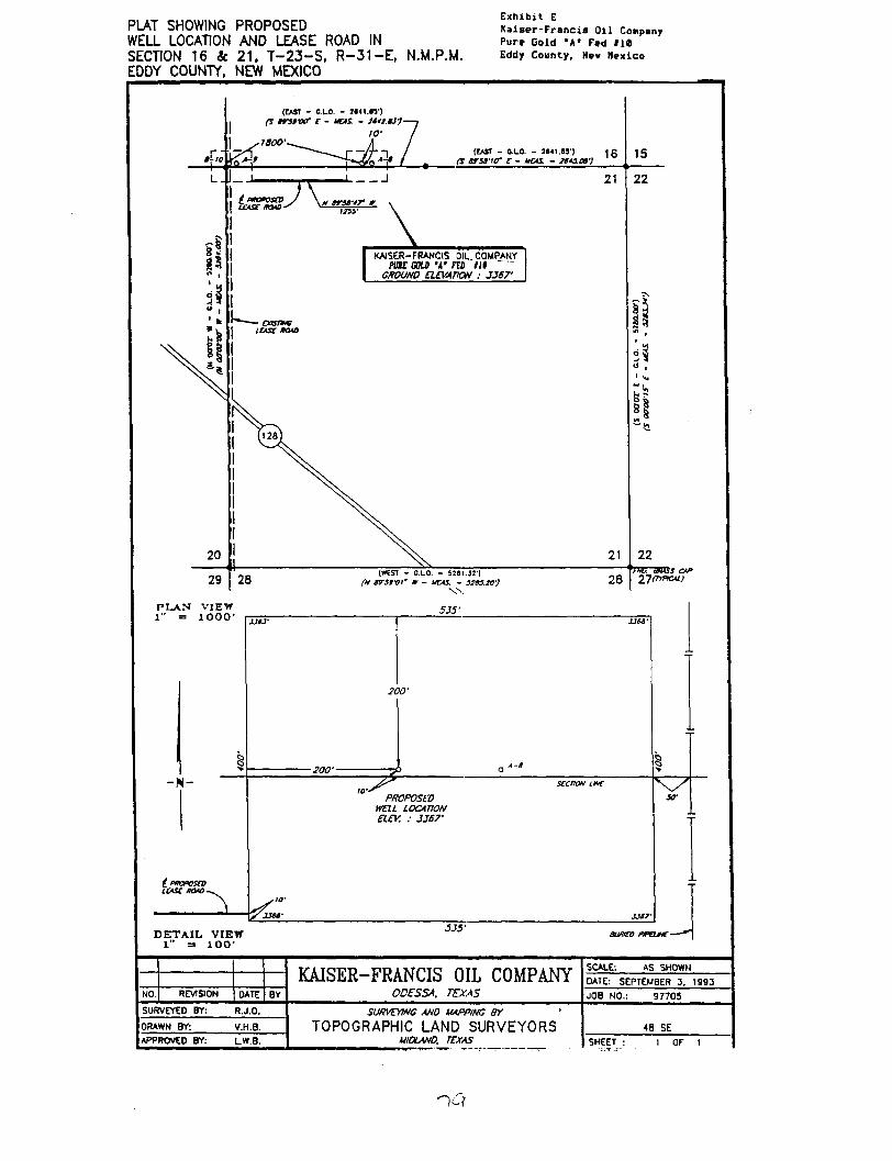
PLAT SHOWING PROPOSED WELL LOCATION AND LEASE ROAD IN SECTION 16 Se 21. T-23-S, R-31-E, N.M.P.M. EDDY COUNTY, NEW MEXICO
Exhibit E
Kaiser-Francis Oil Company Pure Gold "A* Fed 110 Eddy County, Nev Mexico
(CAST - CLO. - 3*<1.<3')
rs irstver r - uas - ittt u-)-w
,,800'. (EAST - OLO. - 2I41.S3') I f i
Cs srst-io- r - uas. - tuiat-)
21
KAISER-FRANCIS OIL COMPANY mt BOLD •«• no lit "
GROUND ELEVATION : JJS7'
21
P L A N V I E W 1" = 1 0 0 0 '
(WEST - 0.L0. - 5381.31'] fit trsrof w - uas. - sias.w)
W
5J5"
28
15
22
" V i
8
22 ' 'rw. Bliss CAP
YI(TiPKAi)
-N-
t PtKPOSCO ICASt HOAO.
200'
-200'-
^7 PROPOSED
WEIL LOCATION ELEV. : JJS7-
IO'
xset-
DETAIL VIEW 1" =• lOO'
535-BWICO pmnr-
KAISER-FRANCIS OIL COMPANY ODESSA. TEXAS
SCALE: AS SHOWN KAISER-FRANCIS OIL COMPANY ODESSA. TEXAS
DATE: SEPTEMBER 3. 1993 NO. REVISION DATE BY
KAISER-FRANCIS OIL COMPANY ODESSA. TEXAS JOB NO.: 97705
SURVEYED BY: R.J.O. SURVEYING ANO MAPPING BY '
TOPOGRAPHIC LAND SURVEYORS MIDLAND. TEXAS
48 SE DRAWN BY: V.H.B.
SURVEYING ANO MAPPING BY '
TOPOGRAPHIC LAND SURVEYORS MIDLAND. TEXAS
48 SE APPROVED BY: LW.B.
SURVEYING ANO MAPPING BY '
TOPOGRAPHIC LAND SURVEYORS MIDLAND. TEXAS SHEET : 1 OF 1
1 0
Submit to In* Appropriate District Office StoU LOOM - 4 copies Fee LOOM - Z copiet
DISTRICT I P. 0 . Box 1980 Hobbs. NM 88240
DISTRICT n P. 0 . Drawer DO Artesia. NM 88210
DISTRICT Fil 1000 Rio Brazos Rd Aztec. NM 87410
SUte of New Mexico Energy, Minerals, and Natural Resources Department
OIL CONSERVATION DIVISION P. 0. Box 2088
Santa Fe, New Mexico B7504-2088
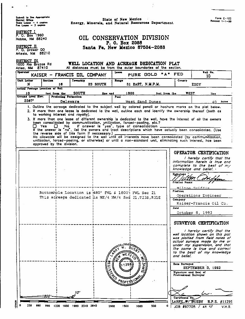
WELL LOCATION AND ACREAGE DEDICATION PLAT All distances must be from the outer boundaries of the section.
Form C-102 Revised 1-1-B9
°P*"U' KAISER - FRANCIS OIL COMPANY P U R E G O L D "A" F E D WeU Na.
10 Unit Utter
N SecUoo
18 Toenuhip
23 SOUTH Sanaa
31 EAST. N.M.P.M. County
EDDY Actual Footage LocaUoa of Wall
10 feet from Lhe S O U T H line end 1800 feet from the WEST line Ground Level SI**. Producing Formation Pool
3367' Delaware West Sand Dunes 4 0 Acres
1. Outline the acreage dedicated to the subject well by colored pencil or hachure marks on the plat below. 2. If more than one lease is dedicated to the well, outline each and identify the ownership thereof (both as
to working interest and royalty). 3. If more than one lease of different ownership Is dedicated to the well, have the Interest of all the owners
been consolidated by communitization. unitization, forced—pooling, etc.? • Yes O No If answer is "yes", type of consolidation If the answer is "no", list the owners and tract descriptions which have actually been consolidated. (Use the reverse side of this form if neccessory.) No allowable will be assigned to the well until all interests have been consolidated (by communitization, unitization, forced-pooling, or otherwise) or until a non-standard unit, eliminating such interest, has been approved by the division.
Boct T h i s a
omhDl cjreag
e Location is e dedicated
1480' FNL & 1800 l is NE/4 NW/4 Se<
FWL Sec 21 21,T23S,R31E
Z2Q 660 990 1630 1980 2310 2640 2000 1900 1000 SOO
OPERATOR CERTIFICATION / hereby certify that the
information herein is true and compiete to the best of my knowledge and belief. •
PodUoa
Operat ions Ena inee i Compeer
K a i s e r - F r a n c i s O i l Co. Dale
October 8, 1993
SURVEYOR CERTIFICATION / hereby certify that the
well location shown on this plat was plotted from field notes of actual surveys mode by me or under my supervision, and that the same is true and correct to the best of my knowledge and belief.
Data Surveyed SEPTEMBER 3. 1993
Signature and Seal af Professional Surveyor
JOB 097705 / 4H SF" V.H.B.
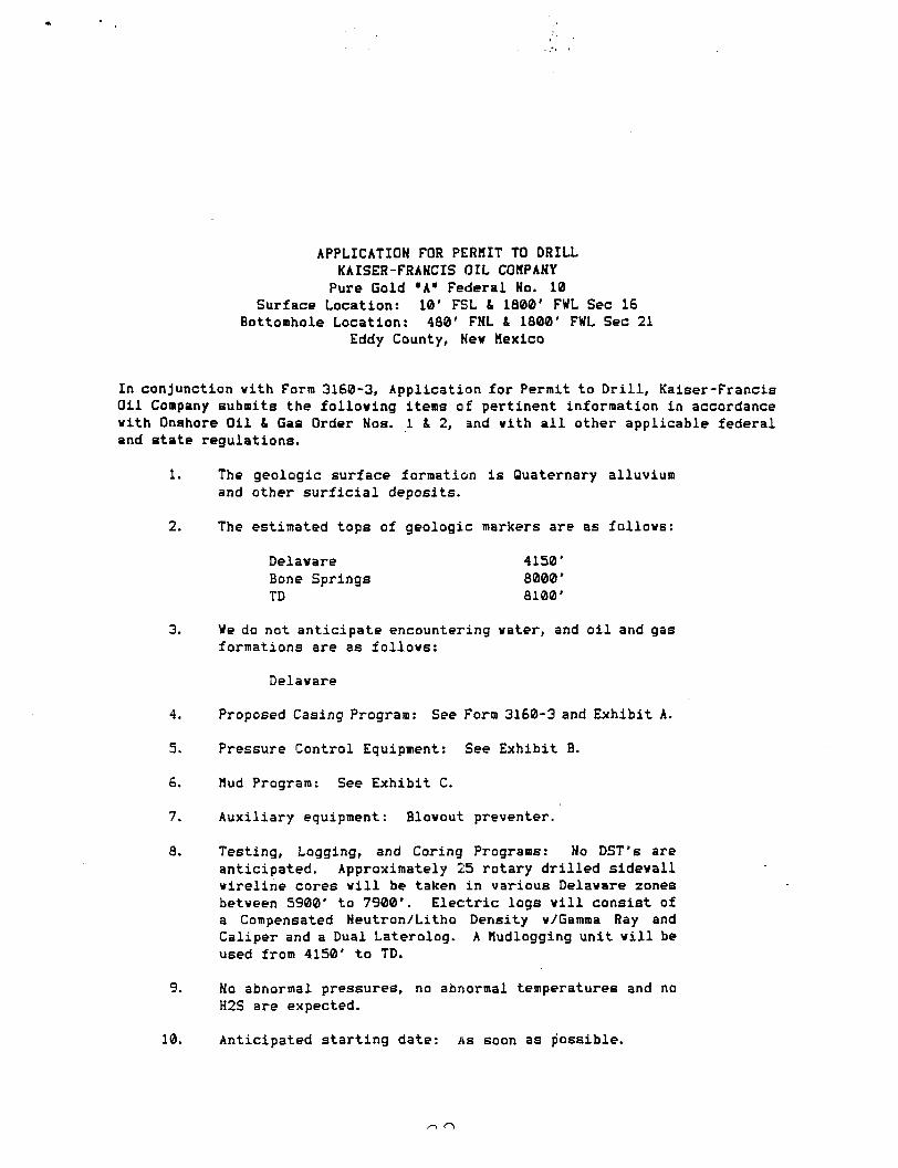
APPLICATION FOR PERMIT TO DRILL KAISER-FRANCIS OIL COMPANY Pure Gold "A" Federal No. 10
Surface Location: 10' FSL & 1800' FWL Sec 16 Bottomhole Location: 480' FNL 1 1800' FWL Sec 21
Eddy County, New Kexico
In conjunction with Form 3160-3, Application for Permit to Drill, Kaiser-Francis Oil Company submits the following items of pertinent information in accordance with Onshore Oil & Gas Order Nos. 1 & 2, and with a l l other applicable federal and state regulations.
1. The geologic surface formation is Quaternary alluvium and other surficial deposits.
2. The estimated tops of geologic markers are as follows:
Delaware 4150' Bone Springs 8000' TD 8100'
3. We do not anticipate encountering water, and oil and gas formations are as follows:
Delaware
4. Proposed Casing Program: See Form 3160-3 and Exhibit A.
5. Pressure Control Equipment: See Exhibit B.
6. Mud Program: See Exhibit C.
7. Auxiliary equipment: Blowout preventer.
8. Testing, Logging, and Coring Programs: No DST's are anticipated. Approximately 25 rotary drilled sidewall wireline cores will be taken in various Delaware zones between 5900' to 7900*. Electric logs will consist of a Compensated Neutron/Litho Density w/Gamma Ray and Caliper and a Dual Laterolog. A Hudlogging unit will be used from 4150' to TD.
9. No abnormal pressures, no abnormal temperatures and no H2S are expected.
10. Anticipated starting date: As soon as possible.
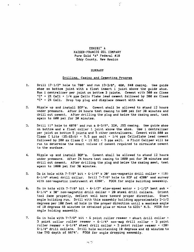
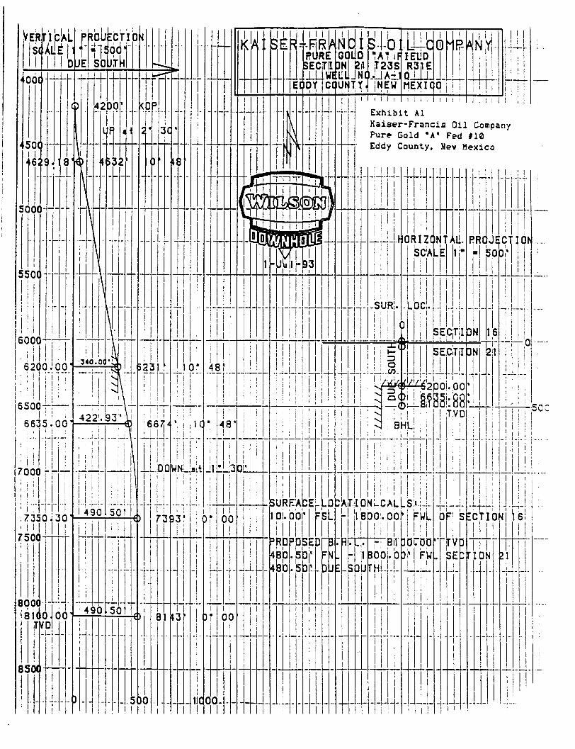
EXHIBIT A KAISER-FRANCIS OIL COMPANY Pure Gold "A" Federal #10 Eddy County, Nev Mexico
SUMMARY
Drilling, Casing and Cementing Program
1. Drill 17-1/2" hole to 700' and run 13-3/8% 48#, H40 casing. Use guide shoe on bottom joint vith a float insert 1 joint above the guide shoe. Run 1 centralizer per joint on bottom 3 joints. Cement vith 500 sx Class •C* * 27. CaCl + 1/4 pps Cello Flake lead cement folloved by 200 sx Class "C" + 2% CaCl. Drop top plug and displace cement vith mud.
2. Nipple up and install BOP's. Cement shall be alloved to stand 12 hours under pressure. After 24 hours test casing to 600 psi for 30 minutes and dr i l l out cement. After drilling the plug and belov the casing seat, test again to £00 psi for 30 minutes.
3. Drill 11" hole to 4070' and run a 8-5/8% 32#, J55 casing. Use guide shoe on bottom and a float collar 1 joint above the shoe. Use 1 centralizer per joint on bottom 5 joints and 5 other centralizers. Cement vith 800 sx Class C Lite (35:65:6) +9.5 pps salt + 1/4 pps Celloflake lead cement folloved by 200 sx Class C • IX KC1 + 5 pps salt. A Fluid Caliper v i l l be run to determine the exact volume cf cement required to circulate cement to the surface.
4. Nipple up and install BOP's. Cement shall be alloved to stand 12 hours under pressure. After 24 hours test casing to 1000 psi for 30 minutes and d r i l l out cement. After drilling the plug and belov the casing seat, test again to 1000 psi for 30 minutes.
5. Go in hole vith 7-7/8" bit + 6-1/4* x 30' non-magnetic d r i l l collar + (18) 6-1/4" steel d r i l l collar. Drill 7-7/8" hole to KOP of 4200' and survey vith non-magnetic instrument at 4200'. POOH for angle building assembly.
6. Go in hole vith 7-7/8" bit • 6-1/2" slov-speed motor • 1-1/2" bent sub • 6-1/4" x 30' non-magnetic d r i l l collar + 20 steel d r i l l collars. Orient tool face properly, deflect veil bore tovard proper direction. Start angle building run. Drill vith this assembly building approximately 2-1/2 degrees per 100 feet of hole in the proper direction until a maximum angle of 10 degrees 48 minutes i s obtained plus or minus to 6231' M.D. POOH for angle holding assembly.
7. Go in hole vith 7-7/8" bit + 6 point roller reamer * short d r i l l collar + 3 point collar roller reamer + 6-1/4" non-mag d r i l l collar • 3 point roller reamer • 6-1/4" steel d r i l l collar • 3 point roller reamer • (20) 6-1/4" d r i l l collars. Drill hole maintaining 10 degrees and 48 minutes to the TVD depth of 6674'. POOH for angle dropping assembly.
Go in hole vith 7-7/8* bit • 6-1/4* non-magnetic d r i l l collar • 3 point roller reamer • (20) 6-1/4" steel d r i l l collars. Drill the hole dropping at 1-1/2 degrees per 100' deviation into the Bone Spring plus or minus 7350.30' TVD. At this point you v i l l be vertical and you v i l l continue to d r i l l to a TVD of 8100'.
Run 5-1/2", 17#, K55 casing vith a stage tool at approximately 6200'. Use a float shoe on bottom and a float collar 1 joint above the shoe. Use 1 centralizer per joint on bottom 5 joints and as required across potential productive intervals. Cement the f i r s t stage vith 580 sx Class H • additives, and cement the second stage vith £90 sx Class C Lite (35:65:6) lead cement folloved vith 100 sx Class C neat. The exact volume to bring the cement top to 4000' v i l l be determined after logging the veil.
Perforations and stimulation treatments v i l l be determined after running electric logs and setting the 5-1/2" casing.
<2 l\
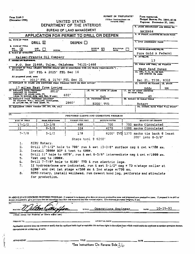
Foim 3160-3 (Dcccrabcf 1990) UNITED STATES
DEPARTMENT OF THE INTERIOR
SUMtlT IN TTUTUCATE* (Olbrr tnalrsjrtlnne an
r i i t m aid*)
Form annroTed, Budget Bureau No. 1004-0136 Expires: December 31, 1991
BUREAU OF LAND MANAGEMENT NM38464
APPUCATION FOR PERMIT TO DRILL OR DEEPEN l i . T i r a or "oaa
DRILL B DEEPEN • • . T i r a or W E L L
ott rrn OAB r—1 atHoi.a rrri Miii.TtrLa 1—1 W E L L USJ WELL. 1 1 o in in ZONE U5J ZONE 1 1
l i . T i r a or "oaa
DRILL B DEEPEN • • . T i r a or W E L L
ott rrn OAB r—1 atHoi.a rrri Miii.TtrLa 1—1 W E L L USJ WELL. 1 1 o in in ZONE U5J ZONE 1 1
l i . T i r a or "oaa
DRILL B DEEPEN • • . T i r a or W E L L
ott rrn OAB r—1 atHoi.a rrri Miii.TtrLa 1—1 W E L L USJ WELL. 1 1 o in in ZONE U5J ZONE 1 1 8. PAAM OA LBASa (MM* M U . M
Pure Gold A F e d e r a l 2. HAH a or oraaAToa
K a i s e r - F r a n c i s O i l Company
8. PAAM OA LBASa (MM* M U . M
Pure Gold A F e d e r a l 2. HAH a or oraaAToa
K a i s e r - F r a n c i s O i l Company 13
P.O. Box 21468, T u l s a , Oklahoma 74121-1468 13
P.O. Box 21468, T u l s a , Oklahoma 74121-1468 10. r i iLS AMD rooL, oa WILDCAT 4. UJCATIO* or w i u (Report loeatloa clcarl? and la accordance wILn any 8 U U requtremtata.*)
At rtMrt«ce , 10' F S L & 2025* F E L Sec 16
At proposed prod, I S B *
2012' FNL & 2176' FEL Sec 21 I t . DtaTAMCa in MtLCa AND BISECTION TBOK N E A E I S T TOWN oa rosT orrica*
17 miles East from Loving
0. LSA
West Sand Dunes 11. sac, T.. a, M, oa SLB.
Sec 21, T23S, R31E IZ. COUNTT oa TAAtan
2012' 10. DISTANCE raou raoraaco* LOCATION TO XE4.EEST raoraaTT oa LCABB LIMB, rr . (Also to aeareat drlt. aalt liar. If anri 692'
13. DifiTAHca r«o« raoroaan LOCATION* TO NEJAEEST Wtl.U SaiLLtRO. COMTLATIO. 0* Arruas roa. sn Tina LSASS, rr. 2860'
J0 . NO. o r J C A I S IN LEASE
540.. 10. rniirOBtn otrTii
8200' TVD
Eddy
i l . BTATB
NM 17. »o. or Acasa Aaaianio
TO T I I I B W B L L
40 20. ROTAat oa CABLB TOOLS
Rotary 21. ELEVATIONS (Show whether DF, UT. GR. etc.) 22. Arraoz. DATX w o n WILL BTAST*
PROPOSED CASINO ANO CEMENT1NO PROGRAM
SIZE or noLX OtlADfl SI7JI or CMINO W I I O I I T rr.« rooT SETTISO nsrrii Q U A N T I T Y or C B M B H T
17-1/2 13-3/8 48# 700 700 sacks Circu la ted 11 8-5/8 32# 4070 1000 sacks Circulated
7-7/8 5-1/2 17# 8200' TVE 1370 sacks t i e back § least 4. , a c-nn>
2°0' into 8-5/8" Stage tool % 6^00' 1. MTRU Rotary. 2. D r i l l 17-1/2" hole to 700' run 8, set 13-3/8" surface csg & cmt »/70>0 sx. 3. I n s t a l l 3000# BOP & test to 600#. 4. D r i l l 11" hole to 4070', run & set 8-5/8" intermediate csg & cmt w/1000 sx. 5. Test csg to 1000#. 6. D r i l l 7-7/8" hole to 8100' TVD & run electric logs. 7. I f hydrocarbons are indicated, run & set 5-1/2" csg •* TD v/stage c o l l a r at
6200' and cmt 1st stage v/580 sx & 2nd stage w/790 sx. 8. RDM0 rotary, i n s t a l l wellhead, run cement bond log, perforate and stimulate
for production.
IN ADOVC srACTi DGSCRIDC TROPOSED rHOCRAM: If proposal l« lo deepen give data on present productive zone and proposed new productive zone. If proposal Ii lo drill or drtpen direcdonally, give pertinent data on subsurface location* and measured and true vertical depths. Give blowout preventer program. It any.
TITI.I: Operat ions Engineer „» T t 10-29-93
(Thla i>l'*ct 'or Federal or State otDre uar)
rr.nMiT so ApmorAt. DATR
Appliealion approval does not warrant or certify that lite applicant holds legal or rquiLible title to those ri|lu In die subject lease wluch would entitle the applicant to conduct rferationa (hereon,
CONDITIONS or ArmovAjL, i» AMYI
A/mOVEO »Y TITLE
*Se« Initructiotu On R«vtn« S ide^
DATS
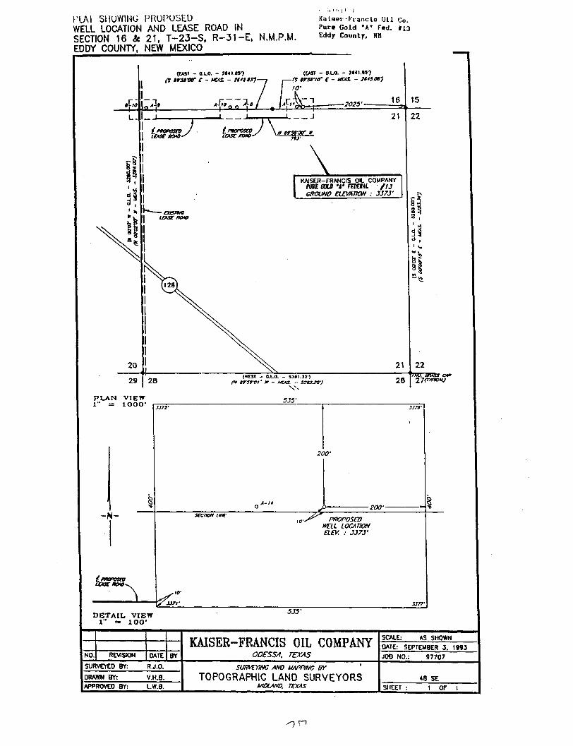
PlAI SHOWING PROPOSED WELL LOCATION AND LEASE ROAD IN SECTION 16 St 21, T-23-S, R-31-E* N.M.P.M. EDDY COUNTY, NEW MEXICO
• ; ' i Kalaer-Francis UU Co. Pure Gold *A* Fed. 113 Eddjr County, Ntl
(EASI - O.LO. - mi «i ft irnxxr r . uas. - ttii.$s-)
'froo
(EAST - O.LO. - J«4I.»S-) ft $rsrt<r t - nets. - tt4i.o»-)
-102S4-16
iCAse too 7 J I
FRQTOStU ~exsr FC*O
T T — I I 21
trst-xr v
• oasme uxsr KOAD
KAISER—FRANCIS OIL COMPANY
me me rmuL /u GROUND ELEVATION : JJ7J'
15
22
21
P L A N VIErT 1" = lOOO"
(«TSI - 0.LO. - 53SI.3J )
fl* t r i t v f tr - utAS. - STSSJO-J
5J51
28
S3
"V,
!1
22 7*H CAP
27(TmtMJ
- N -
£ PlfOPOSTD
stvnau («r PROPOSED WEIL LOCATION ELEV. : JJ7J'
to-
D E T A I L VIEW 1" = l O O '
5JS-
KAISER-FRANCIS OIL COMPANY ODESSA, TEXAS
SCALE: AS SHOWN KAISER-FRANCIS OIL COMPANY ODESSA, TEXAS
DATE: SEPTEMBER 3. 1993 NO. REVISION DATE BY
KAISER-FRANCIS OIL COMPANY ODESSA, TEXAS JOB NO.: 97707
SURVEYED BY: R.J.O. SURVEYING ANO MAPPING BY
TOPOGRAPHIC LAND SURVEYORS MIDLAND. TEXAS
48 SE DRAWN BY: V.H.8.
SURVEYING ANO MAPPING BY
TOPOGRAPHIC LAND SURVEYORS MIDLAND. TEXAS
48 SE APPROVED BY: L.W.8.
SURVEYING ANO MAPPING BY
TOPOGRAPHIC LAND SURVEYORS MIDLAND. TEXAS SHEET : 1 OF 1
n 0
u <• —4
•a o u Lu x:
tn
• u < c B
—* ro < u TJ c
Lv —4 3 l 0 O
- 4 U u -3 Oi •H w « >» -w u •a
ro 3 •o Ul a. u
Submit te the Aacwopne'* Ootrict Offfc* Slot* I N H - « copies Fea Laos* — 3 copiaa
DISTRICT I P. (J. Box 1980 Hobbs. NM 88240
DISTRICT tl P. 0. Drawer DO Artesia. NM 88210
DISTRICT HI 1000 Rio Brazos Rd Aztec. NM 87410
State of New Mexico Energy, Minerals, and Natural Resources Department
OIL CONSERVATION DIVISION P. 0. Box 2088
Santa Fe, New Mexico 87504-2088
WELL LOCATION AND ACREAGE DEDICATION PLAT All distances must be from the outer boundaries of the section.
form C - I CT Revtted 1-1-89
Operator
KAISER - FRANCIS OIL COMPANY U " * P U R E G O L D F E D E R A L
Well Ne.
13 Unit Ut ter
0 Section
16 T e n a b i p
23 SOUTH Raaf*
31 EAST. N.M.P.M. County
EDDY
10 taat from tha SOUTH Una and 2025 feet from tha EAST Un< Ground Laval tier. PToductna. formation Pool 40 3373' Delaware West Sand Dunes 40
Aerea
1. Outline the ocreage dedicated to the subject well by colored pencil or hachure marks on the plot below. 2. If more than one leose is dedicated to the well, outline each and identify the ownership thereof (both as
to working interest ond royalty). 3. If more thon one lease of different ownership is dedicated to the well, have the interest of all the owners
been consolidated by communilizotion. unitization, forced—pooling, etc.? Q Yes • No If answer is "yes", type of consolidation If the answer is "no", list the owners ond tract descriptions which have actually been .consolidated. (Use the reverse side of this form if neccessary.) No allowable will be assigned to the well until oil interests hove been consolidated (by communitization, unitization, forced—pooling, or otherwise) or until a non-standard unit, eliminating such interest, has been approved by the division.
Bottojrihole_Loj£atJ.on2_ The aareage dedicated the Svj/4 NE/4 Sec 21,
2012J FNL_S_ 2174' to t h i s wel l i s +
T23S,R31E
F E L , Sec 21
to-
OPERATOR CERTIFICATION / hereby certify that the
information herein is true and complete to the best of my knowledge and belief.
Printed Name X /
Milton G r i f f i n Position
f l n a r a f i o f g g n r p n<o<a>-Companr
K a i s e r - F r a n c i s O i l Co. Data
October 29. i ° 9 3
SURVEYOR CERTIFICATION / hereby certify that the
well location shown on this plat was plotted from field notes of actual surveys made by me or under my supervision, and that the same is true and correct to the best of my knowledge and belief.
-2025'-
330 860 990 1330 1650 1980 2310 2640 2000 1300 1000 SOO
Data Surveyed
SEPTEMBER 3, L993 Slfueture and Seal of Professional Surveyor
CerUfleata-Nor'
LARfiT W. BUSBY R.P.S. #11398 JOS #97707 / 4g V.H 3.
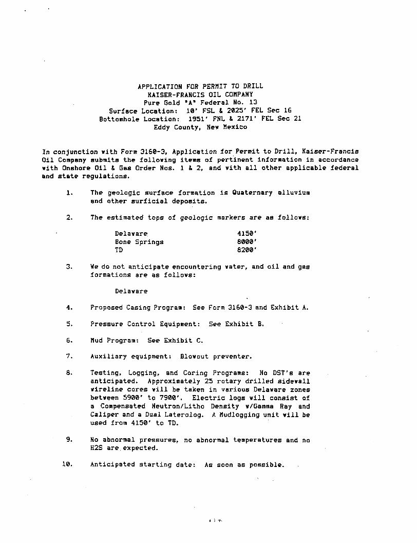
APPLICATION FOR PERMIT TO DRILL KAISER-FRANCIS OIL COMPANY
Pure Gold "A" Federal No. 13 Surface Location: 10' FSL & 2825' FEL Sec 16
Bottomhole Location: 1951* FNL & 2171' FEL Sec 21 Eddy County, New Mexico
In conjunction with Form 3160-3, Application for Permit to D r i l l , Kaiser-Francis Oil Company submits the following items of pertinent information in accordance with Onshore Oil & Gas Order Nos. 1 & 2, and with a l l other applicable federal and state regulations.
1. The geologic surface formation i s Quaternary alluvium and other s u r f i c i a l deposits.
2. The estimated tops of geologic markers are as follows:
Delaware 4150' Bone Springs 8000' TD 8200'
3. Vie do not anticipate encountering water, and o i l and gas formations are as follows:
Delaware
4. Proposed Casing Program: See Form 3160-3 and Exhibit A.
5. Pressure Control Equipment: See Exhibit B.
6. Mud Program: See Exhibit C.
7. Auxiliary equipment: Blowout preventer.
8. Testing, Logging, and Coring Programs: No DST's are anticipated. Approximately 25 rotary drilled sidewall wireline cores will be taken in various Delaware zones between 5900' to 7900'. Electric logs will consist of a Compensated Neutron/Litho Density w/Gamma Ray and Caliper and a Dual Laterolog. A Mudlogging unit will be used from 4150' to TD.
9. No abnormal pressures, no abnormal temperatures and no H2S are expected.
10. Anticipated starting date: As soon as possible.
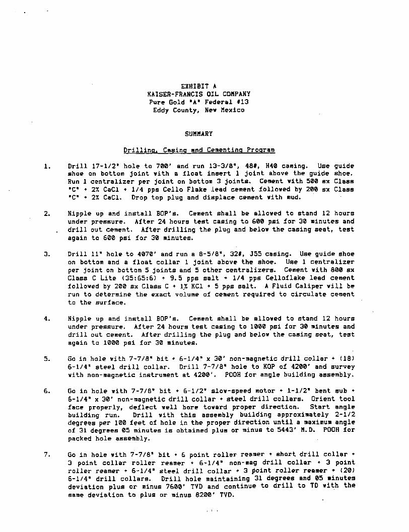
EXHIBIT A KAISER-FRANCIS OIL COMPANY Pure Gold "A* Federal *13 Eddy County, Ne* Mexico
SUMMARY
Drilling, Casing and Cementing Program
1. D r i l l 17-1/2" hole to 700' and run 13-3/8", 48#, H40 casing. Use guide shoe on bottom joint vith a float insert 1 joint above the guide shoe. Run 1 centralizer per joint on bottom 3 joints. Cement with 500 sx Class •C* + 27. CaCl • 1/4 pps Cello Flake lead cement followed by 200 sx Class "C" • 2X CaCl. Drop top plug and displace cement with mud.
2. Nipple up and in s t a l l BOP's. Cement shall be allowed to stand 12 hours under pressure. After 24 hours test casing to 600 psi for 30 minutes and d r i l l out cement. After drilling the plug and below the casing seat, test again to 600 psi for 30 minutes.
3. D r i l l 11" hole to 4070' and run a 8-5/8", 32#, J55 casing. Use guide shoe on bottom and a float collar 1 joint above the shoe. Use 1 centralizer per joint on bottom 5 joints and 5 other centralizers. Cement with 800 sx Class C Lite (35:65:6) • 9.5 pps salt + 1/4 pps Celloflake lead cement followed by 200 sx Class C • 17. KC1 • 5 pps salt. A Fluid Caliper w i l l be run to determine the exact volume of cement required to circulate cement to the surface.
4. Nipple up and in s t a l l BOP's. Cement shall be allowed to stand 12 hours under pressure. After 24 hours test casing to 1000 psi for 30 minutes and d r i l l out cement. After drilling the plug and below the casing seat, test again to 1000 psi for 30 minutes.
5. Go in hole with 7-7/8" bit • 6-1/4" x 30' non-magnetic d r i l l collar + (18) 6-1/4" steel d r i l l collar. D r i l l 7-7/8" hole to KOP of 4200' and survey with non-magnetic instrument at 4200'. POOH for angle building assembly.
6. Go in hole with 7-7/8" bit • 6-1/2" slow-speed motor + 1-1/2" bent sub + 6-1/4" x 30' non-magnetic d r i l l collar + steel d r i l l collars. Orient tool face properly, deflect well bore toward proper direction. Start angle building run. D r i l l with this assembly building approximately 2-1/2 degrees per 100 feet of hole in the proper direction until a maximum angle of 31 degrees 05 minutes i s obtained plus or minus to 5443' M. D. POOH for packed hole assembly.
7. Go in hole with 7-7/8" bit • 6 point roller reamer • short d r i l l collar • 3 point collar roller reamer • 6-1/4" non-mag d r i l l collar • 3 point roller reamer * 6-1/4" steel d r i l l collar • 3 doint roller reamer • (20) 6-1/4" d r i l l collars. D r i l l hole maintaining 31 degrees and 05 minutes deviation plus or minus 7600' TVD and continue to d r i l l to TD with the same deviation to plus or minus 8200' TVD.
8. Run 5-1/2", 17#, K55 casing vith a stage tool at approximately 6200'. Use a float shoe on bottom and a float collar 1 joint above the shoe. Use 1 centralizer per joint on bottom 5 joints and as required across potential productive intervals. Cement the first stage vith 580 sx Class H • additives, and cement the second stage vith 690 sx Class C Lite (35:65:6) lead cement folloved vith 100 sx Class C neat. The exact volume to bring the cement top to 4000' v i l l be determined after logging the veil.
9. Perforations and stimulation treatments v i l l be determined after running electric logs and setting the 5-1/2" casing.
U 0
FOCB 3161-3 (Dcccabcr 1990) UNITED STATES
DEPARTMENT OF THE INTERIOR BUREAU OF LAND MANAGEMENT
SUBMIT IH TRIPLICATE' (Otaer laetrattlaae • •
reverse side)
Ford approved. Budfet Bureau No. 1004-0136 Eaplrea: Deeeoiber 31, 1991
APPLICATION FOR PERMIT TO DRILL OR DEEPEN la. T i n or woaa
0. T t r t or W I L L OIL
DRILL B
•
DEEPEN • OAS W I L L
• INOLB K71 XOHB laJ
MUl.TlrLB u m
2. HASIB or oraiAToa
Kaiser -Franc i s O i l Company
•
P P . Box 21468. Tu^sa, Oklahoma 74121-1468 4. LOCATION or W I L L (Report loeaUea clearly aad la aceerdaace wltb any Slate reonlresscata.*)
AI aarface Surface: 10' FSL fi 2160' FEL Sec 16
At prapeaed prod, aeae
Bottomhole: 480' FNL fi 2160' FEL Sec 21 M. DIHTAMCI in MiLia ARB DISSCTIOH raoM HBASSST TOWH oa roar orrica*
17 miles East from Loving
s. LBABB oasieaAxtoa aaa eaauL ao.'
NM38464
a. ir laeua, ALLOTtaa oa TSISS SAWS
T. parr aoaaaataaT KAMB
8. lAaHoai
Pure Gold A Federal "57"
14 10. riaL> ana roou oa WILBCAT
West Sand Dunes 11. aac a„ at, oa » L « .
aaa BOBTBT oa A aaa
Sec 21,T23S,R31E 12. COOHTT oa rasian
Sddy
I I . BTATS
NM 10. BtaTAnci raoM Moruata*
LOCATION TO KIABIST riortart oa Laasa um, rr. 4 8 0 ' BHL tAlae ta acarest arts, aalt llac. If aap , 4 8 0 '
13. DiaTAHrc rao« raoroaco LOCATION* TO K taa K I T WCLU BBILUHO. courizTso,
BHL
oa arruaa roa, SM mis LSASS. rr. 2660'
18. no. or acaaa IH u m
640 10. raoroaco » m i
8100 TVD
17. HO. or acaaa ABBIOHBD TO Titta W I L L
40 20. BOTABI oa CABLS TOOLS
Rotary XI. ILBVATIONS (Shew whether OF. RT, GR. ate.)
3372' GL 22. arraoz. OATS WOBK W I L L STAST*
23. PROPOSED CASINO AND CZMENTINa PROGRAM
• i i s or I I O L S
17-1/2
7 -7 /8
osAoo. siaorosuw
13-3/8 8 - S / B 5-1/2
WSIOIIT rta rooT
48# _22i_
•rrTt.ta g i r tu
700 4070
17#
Stage tool @ 6200'
8100 TVD
QUAHTITT Or C8HBHT
700 sacks' circulated 1000 sacks circulated 1370 sacks tie back @ least
200' into 8-5/8"
1. 2. 3. 4. 5. 6. 7.
MIRU Rotary. D r i l l 17-1/2" hole to 700', run & set 13-3/8" surface csg fi cmt w/700 sx. Install 3000# BOP & test to 600#. Dr i l l 11" hole to 4070', run S set 8-5/8" intermediate csg & cmt w/1000 sx. Test csg to 1000#. D r i l l 7-7/8" hole to 8100' TVD fi run electric logs. I f hydrocarbons are indicated, run & set 5-1/2" csg fi TD w/stage collar at 6200' and cmt 1st stage w/850 sx & 2nd stage w/790 sx. RDMO rotary, install wellhead, run cement bond log, perforate and stimulate for production.
tH ABOVE SPACE OESCRIOG PROPOSED PROGRAM: It propoaal la ta deepen. | l»e data on preacnt productive tarn aad proposed new productive sens. If proposal It lo drill or deepen dlractlenally, five pertinent data on aubeurfaca locations and nMaaurcd and true vertical depthe. Olve blowout preventer prcaraaa. If any.
-1"-^^^^^^^^^r^* TITLE O p e r a t i o n s E n g i n e e r DATC 1 0 - 8 - 9 3 .
(Tula space for Federal or State office tier)
m a i T *n .»•. . / . .- .•
Application approval does not wisrant or osiuTy Out the arejllcaiil Iwldi
COrlOt I WHS Of AWtOVAL, IP AHTt
• AT raovto BY TfTLI
*S«e Instructions On Revent Side q U DAT!
PLAT SHOWING PROPOSED WELL LOCATION AND LEASE ROAD IN SECTION 16 it 21, T - 2 3 - S , R -31 -E . N.M.P.M. EDDY COUNTY, NEW MEXICO
Exhibit E Xaiaar-Franela Oil Coapany Pur* Gold •*• Fad 114 Eddy County, N>« Haxlco
20
(FAST - 04_0. - M41.M')
f t irsroer t - uas. - mi. is-) (lAST - 04.0. - M 4 t . t r )
—ft i m tcr t - uas. - ittsot-)
KAISER-FRANCIS OIL COMPANY mtatD M* ro in GROUND ELEVATION : JJ72'
txsntc ICASC MHO
21
29 | 28
PLAN VIEW 1" = lOOO'
(WEST - O LO. - S i a i J l ' ) (tt srstvr w - uas - SIOSJO-)
W
535'
28
55 S3
22 'IW. SUSS CAP
ncneiCAi)
200'
-N-
1ST BOiD
-200-
o- PROPOSED HELL LOCATION ELEV. : JJ72-
sccnott uttt
IO-
JJ? r DETAIL VIEW
1" = lOO'
535-
KAISER-FRANCIS OIL COMPANY ODESSA. TEXAS
SCALE: AS SHOWN KAISER-FRANCIS OIL COMPANY ODESSA. TEXAS
OATE: SEPTEMBER 3. 1993 NO. REVISION OATE BY
KAISER-FRANCIS OIL COMPANY ODESSA. TEXAS JOB NO.: 97708
SURVEYED BY: RJ.O. SURVEYING AND MAPPING BY
TOPOGRAPHIC LAND SURVEYORS MIDLAND. TEXAS
48 SE DRAWN BY: V.H.B. SURVEYING AND MAPPING BY
TOPOGRAPHIC LAND SURVEYORS MIDLAND. TEXAS
48 SE APPROVED BY: L.W.B.
SURVEYING AND MAPPING BY
TOPOGRAPHIC LAND SURVEYORS MIDLAND. TEXAS SHEET : 1 OF 1
I I t-r
500
Sukmal ta tn* Aaavapriata Ostriet OMea State Laaaa - 4 Faa taaaa - 3
DISTRICT I P. 0" Box 1980 Hobbs. NM 88240
JL pT^F^rower DO Artesia. NM 88210
DISTRICT HI 1000 Rio Brozos Rd Aztec. NM 87410
SUte of New Mexico Energy, Minerals, and Natural Resources Department
OIL CONSERVATION DIVISION P. 0. Box 2088
Santa Fe, New Mexico 87504-2088
WELL LOCATION ANO ACREAGE DEDICATION PLAT All distances must be from the outer boundaries of the section.
Form C-103 Revised l - t -81
Oaaraler KAISER - FRANCIS OIL COMPANY P U R E G O L D F E D Vol! No.
14 Uail Beetle*
16 Tasmania
23 SOUTH Sanaa
31 EAST. N.M.P.M. actual FaaUfa Laeatlaa of Wall
10 fact from the SOUTH
County EDDY
Greun4 Level Ba*."
3372'
Une snd 2160 feat frorn the EAST line Producing FonnaUen
Delaware Pool
W e s t S a n d Dunes Aerei
1. Outline the ocreoge dedicoted to the subject well by colored pencil or hachure marks on the plot below. 2. If more than one lease is dedicoted to the well, outline each and identify the ownership thereof (both as
to working interest and royalty). 3. If more than one lease of different ownership is dedicoted to the well, have the interest of ail the owners
been consolidated by communitization, unitization, forced-pooling, etc.? Q Yes D No If answer is "yes", type of consolidation \ If the answer is "no", list the owners and tract descriptions which have actually been consolidated. (Use the reverse side of this form if neccessary.) No allowable will be assigned ta the well until all interests hove been consolidated (by communitization, unitization, forced-pooling, or otherwise) or until a non-standard unit, eliminating such interest, has been approved by the division.
Bottomhole! Location i s 480J' FNL & 2160' F L Sec 21
This acreabe dedicated to }the subject well! NE/4 Sec i21, T23S, R31E
is the NW/4
0*| 330 M0 990 1330 ISM 1980 33 110 2840 1300 1000
OPERATOR CERTIFICATION / hereby certify that the
information herein is true and complete to the best of my knowledge and belief.
Printed Name
M i l t o n G r i f f i n PodUoa Operations Engineer
Company Kaiser-Franc i s O i l Co.
Data October 8, 1993
SURVEYOR CERTIFICATION I / hereby certify that the
well location shown on this plat was plotted from field notes of actual surveys made by me or under my supervision, and that the same Is true ond correct to the best of my knowledge and belief.
Data Surrered
SEPTEMBER 3, 1993 Signature and seal at* Professional Surreyer
CartifUata Na. LARRY V. BUSBY R.P.S. 111398
0 JOB #97708 / 48 SE V.H.B.
APPLICATION FOR PERMIT TO DRILL KAISER-FRAHCIS OIL COMPANY Pure Gold *A* Federal Ho. 14
Surface Location: 10' FSL I 2160' FEL Sec 16 Bottomhole Location: 480' FNL & 2160' FEL Sec 21
Eddy County, Nev Hexico
In conjunction with Form 3160-3, Application for Permit to Drill, Kaiser-Francis Oil Company submits the following items of pertinent information in accordance vith Onshore Oil & Gas Order Nos. 1 & 2, and vith a l l other applicable federal and state regulations.
1. The geologic surface formation i s Quaternary alluvium and other surficial deposits.
2. The estimated tops of geologic, markers are as follovs:
Delavare 4150' Bone Springs 6000' TD 8100'
3. We do not anticipate encountering vater, and o i l and gas formations are as follovs:
Delavare
4. Proposed Casing Program: See F'orm 3160-3 and Exhibit A.
5. Pressure Control Equipment: See Exhibit B.
6. Mud Program: See Exhibit C.
7. Auxiliary equipment: Blovout preventer.
8. Testing, Logging, and Coring Programs: No DST's are anticipated. Approximately 25 rotary drilled sidevall wireline cores v i l l be taken in various Delaware zones between 5900' to 7900'. Electric logs v i l l consist of a Compensated Neutron/Litho Density w/Gamma Ray and Caliper and a Dual Laterolog. A Mudlogging unit will be used from 4150' to TD.
9. No abnormal pressures, no abnormal temperatures and no H2S are expected.
10. Anticipated starting date: As soon as possible.
/ i fi
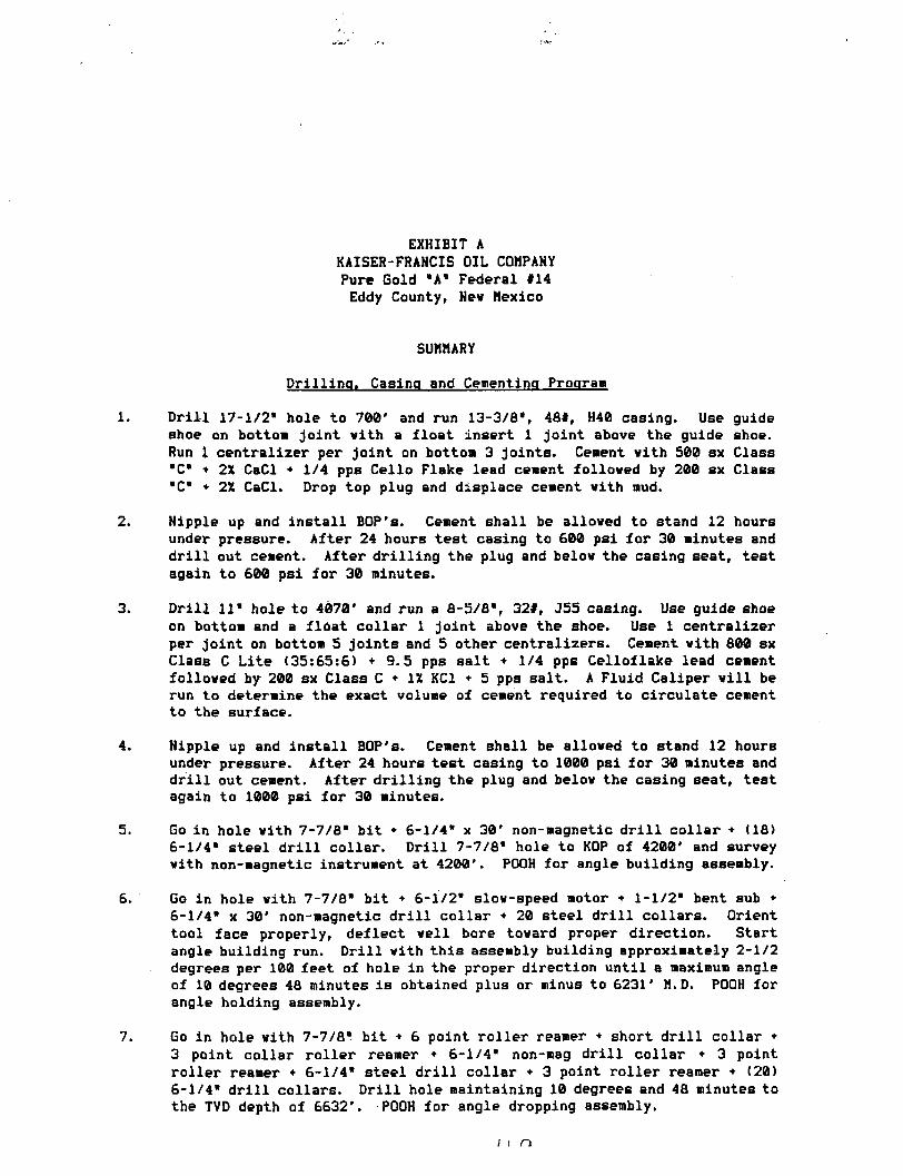
EXHIBIT A KAISER-FRANCIS OIL COMPANY Pure Gold "A* Federal #14 Eddy County, Nev Mexico
SUMMARY
Drilling. Casing and Cementing Program
1. Drill 17-1/2" hole to 708' and run 13-3/8", 48#, H40 casing. Use guide shoe on bottom joint vith a float insert 1 joint above the guide shoe. Run 1 centralizer per joint on bottom 3 joints. Cement vith 500 sx Class "C" * 2X CaCl + 1/4 pps Cello Flake lead cement folloved by 200 sx Class "C" + 21 CaCl. Drop top plug and displace cement vith mud.
2. Nipple up and install BOP's. Cement shall be alloved to stand 12 hours under pressure. After 24 hours test casing to £00 psi for 30 minutes and d r i l l out cement. After drilling the plug and belov the casing seat, test again to 600 psi for 30 minutes.
3. Drill 11* hole to 4070' and run a 8-5/8", 32#, J55 casing. Use guide shoe on bottom and a float collar 1 joint above the shoe. Use 1 centralizer per joint on bottom 5 joints and 5 other centralizers. Cement vith 800 sx Class C Lite (35:65:6) + 9.5 pps salt + 1/4 pps Celloflake lead cement folloved by 200 sx Class C • IX KC1 + 5 pps salt. A Fluid Caliper v i l l be run to determine the exact volume of cement required to circulate cement to the surface.
4. Nipple up and install BOP's. Cement Bhall be alloved to stand 12 hours under pressure. After 24 hours test casing to 1000 psi for 30 minutes and dr i l l out cement. After drilling the plug and belov the casing seat, test again to 1000 psi for 30 minutes.
5. Go in hole vith 7-7/8" bit • 6-1/4" x 30' non-magnetic d r i l l collar • (18) 6-1/4" steel d r i l l collar. Drill 7-7/8" hole to KOP of 4200' and survey vith non-magnetic instrument at 4200'. POOH for angle building assembly.
6. Go in hole vith 7-7/8" bit * 6-1/2" slov-speed motor • 1-1/2" bent sub • 6-1/4" x 30' non-magnetic d r i l l collar • 20 steel d r i l l collars. Orient tool face properly, deflect veil bore tovard proper direction. Start angle building run. Drill vith this assembly building approximately 2-1/2 degrees per 100 feet of hole in the proper direction until a maximum angle of 10 degrees 48 minutes i s obtained plus or minus to 6231' M.D. POOH for angle holding assembly.
7. Go in hole vith 7-7/8" bit • 6 point roller reamer + short d r i l l collar • 3 point collar roller reamer • 6-1/4" non-mag d r i l l collar • 3 point roller reamer + 6-1/4" steel d r i l l collar + 3 point roller reamer • (20) 6-1/4" d r i l l collars. D r i l l hole maintaining 10 degrees and 48 minutes to the TVD depth of 6632'. POOH for angle dropping assembly.
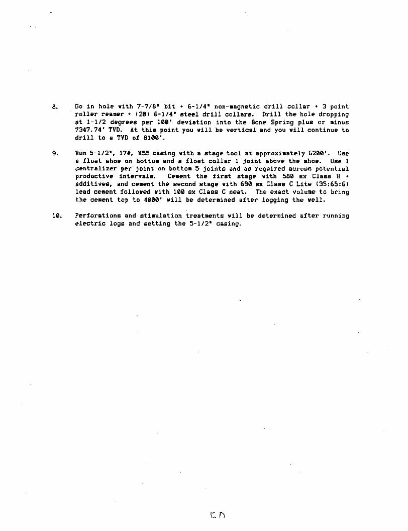
8. Go in hole with 7-7/8* bit • 6-1/4" non-magnetic d r i l l collar + 3 point roller reamer • (20) 6-1/4* steel d r i l l collars. Drill the hole dropping at 1-1/2 degrees per 100' deviation into the Bone Spring plus or minus 7347.74' TVD. At this point you will be vertical and you will continue to d r i l l to a TVD of 8100'.
9. Run 5-1/2*, 17#, K55 casing with a stage tool at approximately 6200*. Use a float shoe on bottom and a float collar 1 joint above the shoe. Use 1 centralizer per joint on bottom 5 joints and as required across potential productive intervals. Cement the f i r s t stage vith 580 sx Class H • additives, and cement the second stage with 690 sx Class C Lite (35:65:6) lead cement followed with 100 sx Class C neat. The exact volume to bring the cement top to 4000' will be determined after logging the well.
10. Perforations and stimulation treatments will be determined after running electric logs and setting the 5-1/2* casing.
Foim 3160-3 (December 1990) UNITED STATES
SUBMIT IM T I U T U C A T E * (Otbrr Inatrurtlnna on
reterae elde)
Torm approved. Dudr.et Bureau Mo. 1004-0136 Expires: December 3 l , 1991
DEPARTMENT OF THE INTERIOR BUREAU OF LAND MANAGEMENT
DEPARTMENT OF THE INTERIOR BUREAU OF LAND MANAGEMENT
0 . LSASS OSS 10NATION AMD S S S I A L HO.
NM38463 APPLICATION FOR PERMIT TO DRILL OR DEEPEN 0. i r I N D I A N . ALLOTTSS OS T S I S S MAMS
I s . T i r a o r WORK
DRILL S DEEPEN • b. T i n o r W E L L
O I L [771 OAR |—1 B I N O L B ren M t n . T i r i a |—| W E L L \ U W E L L 1 1 OTnca r.oxs LCJ t o u t 1 1
0. i r I N D I A N . ALLOTTSS OS T S I S S MAMS
I s . T i r a o r WORK
DRILL S DEEPEN • b. T i n o r W E L L
O I L [771 OAR |—1 B I N O L B ren M t n . T i r i a |—| W E L L \ U W E L L 1 1 OTnca r.oxs LCJ t o u t 1 1
I s . T i r a o r WORK
DRILL S DEEPEN • b. T i n o r W E L L
O I L [771 OAR |—1 B I N O L B ren M t n . T i r i a |—| W E L L \ U W E L L 1 1 OTnca r.oxs LCJ t o u t 1 1 6 . PAKM OS LBASB HAMS. WOU. MO.
Pure Go ld B F e d e r a l 2. N A M E o r o rEBA ioa
K a i s e r - F r a n c i s O i l Company
6 . PAKM OS LBASB HAMS. WOU. MO.
Pure Go ld B F e d e r a l 2. N A M E o r o rEBA ioa
K a i s e r - F r a n c i s O i l Company 9. An WOLL NO.
7 3. M a a s M O n u n D M m
p . n . Rnv 2146S,, T u l s a . OK 74121-1468
9. An WOLL NO.
7 3. M a a s M O n u n D M m
p . n . Rnv 2146S,, T u l s a . OK 74121-1468 1 0 . t i t US AMD TOOL, OB W I L D C A T
West Sand Dunes 4. L O C A T I O N o r W S L L (Repor t locs t loo e les r l r and In sccordsace w i t h a o r State requ i rements . * ) . A t Mi i r iae*
2100 ' FSL & 1 6 0 0 ' FEL A t proposed p rod , l o s e
1988 ' FNL S 1834 ' FEL
1 0 . t i t US AMD TOOL, OB W I L D C A T
West Sand Dunes 4. L O C A T I O N o r W S L L (Repor t locs t loo e les r l r and In sccordsace w i t h a o r State requ i rements . * ) . A t Mi i r iae*
2100 ' FSL & 1 6 0 0 ' FEL A t proposed p rod , l o s e
1988 ' FNL S 1834 ' FEL
1 1 . s a c . T.. a.. H , OS BLB. AMD SUBtE? OB ABBA
Sec 20 , T23S, R31E 1 4 . D I S T A N C E IN M I L S a AMD DISSCTIOK r S O H NEAREST T O W N OH r O S T O r r l C S *
17 m i l e s Eas t f r om L o v i n g
1 2 . C O U N T ! OB T A B I s n I S . STATE
Eddy NM 10. DISTANCE n o w rsorussD* 1 I
LOCATION TO KCABSBT l 0 J 4 raortsTi oa L E A S E L I N E , rr. (Also to B u r n t arl i . unit Hot. If anrt 514'
13. DIBTANfB MOM rROrORED LOCATION* TO Nr.AREST Wtl.l.. DRILLINO. COUrLETED. o« ArruBo roe. on THIS UABC, rr. 1 3 4 0 '
10. NO. or ACHES IN LKABS
ID. I'ltOI'ORED IIErTII
8100' TVD
17. NO. or ACBSH AaaiONEO TO THIS WELL
40 20. ROTA ST OB CABLE TOOLS
Rotary 21. SLBTATIOHS tSbow whether DF, RT, CTk etc)
3341' 22. Armor, BATS u n i t W I L L STAST*
2.1. PROPOSED CASINO AND CEMENTING PROGRAM
size or noLE OSAOB. sia or CUIHO WEIOIIT ren rooT RETTINO D E m i QUANTITY Or CEMENT
17-1/2 13-3/8 48# • 700 700 sacks Circulated 11 8-5/8 32# 4070 1000 sacks Circulated
7-7/8 5-1/2 17# 8100' TVD 1370 sacks t i e back @ least 200' into 8-5/8"
Stage tool @ 6200'
set 13-3/8* surface csg & cmt w/700 sx. 1. HIRU Rotary. 2. D r i l l 17-1/2" hole to 700' run & 3. I n s t a l l 3000# BOP & test to 600#. 4. D r i l l 11" hole to 4070', run & set 8-5/8" intermediate csg & cmt v/1000 sx. 5. Test csg to 1000#. 6. D r i l l 7-7/8* hole to 8100' TVD & run electric logs. 7. I f hydrocarbons are indicated, run & set 5-1/2" csg 9 TD w/stage collar at
6200' and cmt 1st stage w/580 sx & 2nd stage v/790 sx. 8. RDM0 rotary, i n s t a l l wellhead, run cement bond log, perforate and stimulate
for production.
IN ADOVC STACr. DUSCRI0T: rrtorOSCI) PROGRAM: If propmal i« lo deepen, dive daia on preterit productive tone »nd proposed new productive rone. If proposal It lo drill pr deepen directionally, give pertinent data on tub tut face locations and measured and true vertical depths. Give blowout preventer program. It any.
//ZfP*? d rfrfa~i4&**~ Tiri.r. Operations Engineer DATE U r2-93 (Thla apnee for Fedrrnl or SlRte office use)
rr.riMiT NO. . Armor AL oAir..
Application approval does not warrant or certify that the applicant holds legal or equitable title to these riglli In tlie subject lease which would entitle the applicant to conduct operations Ihereon.
CONDITIONS OP ArrROVAi, IP ANYt
ArrRovEonr. TITLE
*S«e Inilfvelioru On Rtvtne Side ^> ^ T i l l " M 1 ' rVC" ' V c t i f n I 1 ^ 1 . m M f r - i l n r : i i - . . - f . , r n n v I ' T r i i n V n o w i n p l v nn<! w i l l f u l l y t f> m * V r I n n n i
PLAT SHOWING PROPOSED WELL LOCATION AND LEASE ROAD IN SECTION 20, T-23-S, R-31-E, N.M.P.M. EDDY COUNTY, NEW MEXICO
L>:lnMt K Kaiser-Francis O i l Co. Pure Gold *B' Fed. 17 Eddy County, NM
18
19
«5
o I
'»
.ft
MO. BRASS
(nvKMJso
19
17 w
(tAST - CLO. - 2«JJ.7J> (M trstvr € - tieAS. - ilit.te-)
(EAST - CLO. - JHJ.7J- ) -I 7
(5 ersrar c - itxs. - 2ih.4r) ''
20 21
16
DOSTWC UASt MV)
SOUTH
2100'
KAISER—FRANCIS OIL COMPANY PURE GOLD FEDERAL 'BT /7 GROUND ELEVATION : 334 V
20 20
29 (WESl
(H tsrsri
P L A N V I E W 1 " = l O O O '
[WEST - O LO. - 528« »4 )
•37nr w - ue*s. - 5j7j.tr •)
400'
29
I ^ — DUSTING 'C UASCIKHO
21
28
D E T A I L V I E W 1" = l O O '
KAISER - FRANCIS OIL COMPANY ODESSA, TEXAS
SCALE: AS SHOWN KAISER - FRANCIS OIL COMPANY ODESSA, TEXAS
DATE: SEPTEMBER 2, 1993 NO. REVISION DATE BY
KAISER - FRANCIS OIL COMPANY ODESSA, TEXAS JOB NO.: 97699
SURVEYED BY: R.J.O. SURVEYING AND MAPPING BY
TOPOGRAPHIC LAND SURVEYORS MIDLAND, TEXAS
48 SE DRAWN BY: V.H.B. SURVEYING AND MAPPING BY
TOPOGRAPHIC LAND SURVEYORS MIDLAND, TEXAS
48 SE APPROVED BY: L.W.B.
SURVEYING AND MAPPING BY
TOPOGRAPHIC LAND SURVEYORS MIDLAND, TEXAS SHEET : 1 OF 1
rr 1
o I_> a*
-a o
U. u
c
u 03 c fc
— cn u TD c
LL. —1 3 I 0 0
-< U, O u — OJ
-< Ul tu >, •H u TJ X rd 3
a. u
buo*ntl l o irm Appropriate District OHM-* Stat* L O O M - * copies Fee L O O M - 3 copiet
DISTRICT I P. 0. Box 1980 Hobbs. NM 88240
DISTRICT tl P. 0. Drawer DD Arlesio. NM 88210
DISTRICT PI 1000 Rio Brazos Rd Aztec. NM 87410
Slate of New Mexico Energy, Minerals, and Natural Resources Department
OIL CONSERVATION DIVISION P. 0. Box 2088
Santa Fe, New Mexico 87504-2088
WELL LOCATION AND ACREAGE DEDICATION PLAT All distances must be f rom the outer boundories of the section.
Form C - 1 0 2 Reviled 1 - 1 - 8 9
Operator KAISER - FRANCIS DIL CDMPANY
Lease PURE GOLD FEDERAL 'B*
Well No.
7 Unit Latter
J SecUon
20 Township Range
23 SOUTH 31 EAST, N.M.P.M. County
EDDY Aetna! Footage LocaUon of Veil
2100 feet from the SOUTH line and 1600 feet from Ute EAST line Ground Level Else.
3341' Pr educing FormaUon
r ia l a u a r o
Pool West Sand Dunes 40 acres
1. Outline the acreage dedicoted to the subject well by colored pencil or hochure marks on the plot below. 2. If more than one lease is dedicoted to the well, outline each and identify the ownership thereof (both os
to working interest and royal ty) .
3. If more thon one lease of different ownership is dedicated to the well, have the interest of all the owners been consolidated by communi t izat ion, unit ization, forced—pooling, etc.? D Yes • No If a n s w e r is " y e s " , t ype of c o n s o l i d a t i o n If the answer is " n o " , list the owners and tract descriptions which hove actually been consolidated. (Use the reverse side of this fo rm if neccessary.) No allowable will be assigned to the well until all interests have been consolidated (by communi t izat ion, unitization, forced—pooling, or otherwise) or until a non-s tandard unit , eliminating such interest, has been approved by the division.
BHL 1988* FNL & 182(4' FEL
2/00'
•1600'-
330 660 990 1320 1650 1980 2310 2640 2000 1500 1000 500
OPERATOR CERTIFICATION / hereby certify that the
information herein is true and complete to the best of my knowledge and belief..
M i l t o n G r i f f i n Position Operations Engineer
Company
Kaiser-Francis O i l Co. Data
November 2, 1993
SURVEYOR CERTIFICATION / hereby certify that the
well location shown on this plat was plotted from field notes of actual surveys mode by me or under my supervision, and that the same is true and correct to the best of my know/edge and belief.
Date Surveyed SEPTEMBER 2. 1993
Signature and Seal of Professional Surveyor
CerUHcaia-Wor LARRY W. BUSBY R.P.S. #11398
JOB #97699 . / 48 SE V.H.B.
APPLICATION FOR PERMIT TO DRILL KAISER-FRANCIS OIL COMPANY
Pure Gold "B* Federal No. #7 Surface Location: 2100' FSL & 1600' FEL
Bottomhole Location: 1988' FNL & 1834' FEL Eddy County, New Mexico
In conjunction with Form 3160-3, Application for Permit to D r i l l , Kaiser-Francis Oil Company submits the following items of pertinent information in accordance vith Onshore Oil & Gas Order Nos. 1 & 2, and with a l l other applicable federal and state regulations.
1. The geologic surface formation i s Quaternary alluvium and other su r f i c i a l deposits.
2. The estimated tops of geologic markers are as follovs:
Delaware 4150' Bone Springs 8000' TD 8100'
3. We do not anticipate encountering water, and o i l and gas formations are as follows:
Delaware
4. Proposed Casing Program: See Form 3160-3 and Exhibit A.
5. Pressure Control Equipment: See Exhibit B.
6. Mud Program: See Exhibit C.
7. Auxiliary equipment: Blowout preventer.
8. Testing, Logging, and Coring Programs: No DST's are anticipated. Approximately 25 rotary drilled sidewall wireline cores will be taken in various Delaware zones between 5900' to 7900'. Electric logs will consist of a Compensated Neutron/Litho Density w/Gamma Ray and Caliper and a Dual Laterolog. A Mudlogging unit will be used from 4150' to TD.
9. No abnormal pressures, no abnormal temperatures and no H2S are expected.
10. Anticipated starting date: As soon as possible.
EXHIBIT A KAISER-FRANCIS OIL COMPANY Pure Gold "B" Federal #7 Eddy County, Nev Mexico
SUMMARY
Drilling. Casing and Cementing Program
1. D r i l l 17-1/2" hole to 700' and run 13-3/8', 48#, H40 casing. Use guide shoe on bottom joint vith a float insert 1 joint above the guide shoe. Run 1 centralizer per joint on bottom 3 joints. Cement vith 500 sx Class "C" • 27. CaCl • 1/4 pps Cello Flake lead cement folloved by 200 sx Class "C" *• 27. CaCl. Drop top plug and displace cement vith mud.
2. Nipple up and in s t a l l BOP's. Cement shall be alloved to stand 12 hours under pressure. After 24 hours test casing to 600 psi for 30 minutes and d r i l l out cement. After drilling the plug and belov the casing seat, test again to 600 psi for 30 minutes.
3. D r i l l 11" hole to 4070' and run a 8-5/8", 32#, J55 casing. Use guide shoe on bottom and a float collar 1 joint above the shoe. Use 1 centralizer per joint on bottom 5 joints and 5 other centralizers. Cement vith 800 sx Class C Lite (35:65:6) +9.5 pps salt * 1/4 pps Celloflake lead cement folloved by 200 sx Class C • 17. KC1 *• 5 pps salt. A Fluid Caliper v i l l be run to determine the exact volume of cement required to circulate cement to the surface.
4. Nipple up and in s t a l l BOP's. Cement shall be alloved to stand 12 hours under pressure. After 24 hours test casing to 1000 psi for 30 minutes and d r i l l out cement. After drilling the plug and belov the casing seat, test again to 1000 psi for 30 minutes.
5. Go in hole vith 7-7/8" bit • 6-1/4" x 30' non-magnetic d r i l l collar + (18) 6-1/4" steel d r i l l collar. D r i l l 7-7/8" hole to KOP of 4150* and survey vith non-magnetic instrument at 4150'. POOH for angle building assembly.
6. Go in hole vith 7-7/8" bit • 6-1/2" slov-speed motor + 1-1/2" bent sub • 6-1/4" x 30' non-magnetic d r i l l collar • steel d r i l l collars. Orient tool face properly, deflect veil bore tovard proper direction. Start angle building run. D r i l l vith this assembly building approximately 2 degrees per 100 feet of hole in the proper direction until a maximum angle of 19 degrees 20 minutes i s obtained plus or minus to 5117' B.D. POOH for packed hole assembly.
7. Go in hole vith 7-7/8" bit + 6 point roller reamer • short d r i l l collar • 3 point roller reamer * 6-1/4" non-magnetic d r i l l collar + 3 point roller reamer • 6-1/4* steel d r i l l collar • 3 point roller reamer + (20) 6-1/4" d r i l l collars. D r i l l hole maintaining 19 degrees 20 minutes deviation plus or minus 7600' TVD and continue to d r i l l to TD vith the same deviation to plus or minus 8100' TVD. j
8. Run 5-1/2", 17#, K55 casing with a stage tool at approximately 6200'. Use a float shoe on bottom and a float collar 1 joint above the shoe. Use 1 centralizer per joint on bottom 5 joints and as required across potential productive intervals. Cement the f i r s t stage with 580 sx Class H + additives, and cement the second stage with 690 sx Class C Lite (35:65:6) lead cement followed with 100 sx Class C neat. The exact volume to bring the cement top to 4000' v i l l be determined after logging the well.
9. Perforations and stimulation treatments will be determined after running electric logs and setting the 5-1/2" casing.
ri_'M ->nv»»iHo r r t u r u o c u WELL LOCATION AND LEASE ROAD IN SECTION 20, T - 2 3 - S , R - 3 1 - E , N.M.P.M. EDDY COUNTY, NEW MEXICO
K;iLnpi 1 i a u d i : Ul I 1 n. Pure Gold "B" Fed. 18 Eddy County, NM
18
19
w 1 7 (EAST - CLO. - 3W3.7J)
20
(CAST - CLO. - 2MJ.73-) fs tnintr e - uas. - tut.4f)
t ° I
ii
no. MASS fnPKMj^O
19 "CAP* *
20
29 . - 526J.44-I
(N trsrscr w - uas - sifxei •) (WEST - O LO.
oasjne LEAST HOW
KAISER-FRANCIS OIL COMPANY PURE GOLD FEDERAL ~LT /B GROUND ELEVATION : 3348'
P L A N V I E W 1" = l O O O '
535'
PROPOSED WELL LOCATION ELEV. : 3348-
pasmc ictsf now
535-
D E T A I L V I E W 1" = l O O "
COSTING LOST *OtC
KAISER - FRANCIS OIL COMPANY ODESSA, TEXAS
SCALE: AS SHOWN 1 KAISER - FRANCIS OIL COMPANY ODESSA, TEXAS
DATE: SEPTEMBER 2, 1993 1 NO. REVISION DATE BY
KAISER - FRANCIS OIL COMPANY ODESSA, TEXAS JOB NO.: 97701 |
SURVEYEO BY: R.J.O. SURVEYING ANO MAPPING BY
TOPOGRAPHIC LAND SURVEYORS MIDLAND. TEXAS
48 SE 1 DRAWN BY: V.H.B. SURVEYING ANO MAPPING BY
TOPOGRAPHIC LAND SURVEYORS MIDLAND. TEXAS
48 SE 1 APPROVED BY: L.W.B.
SURVEYING ANO MAPPING BY
TOPOGRAPHIC LAND SURVEYORS MIDLAND. TEXAS SHEET : 1 OF 1 |
rota 3160-3 (December 1990) UNITED STATES
DEPARTMENT OF THE INTERIOR
SUBMIT IM T I U r L I C A T E * (Utbrr Inntrurtlont en
rtferae side)
Form, approved. DudRel Bureea No. 1004-0136 Expiree: December 3 l , I991
BUREAU OF LAND MANAGEMENT NM38463
APPLICATION FOR PERMIT TO DRILL OR DEEPEN 0. ir INDIAN, ALLorrce oa Tsisa m m
I t . Ttre or WORK
DRILL H DEEPEN • b. T i r e or W I L L
OIL rrr\ OAR 1—1 SINOLS ran Mm/rirLS 1—1 W E L L L&J W * L L 1 1 omt* ZOHS L2J 10m 1 1
0. ir INDIAN, ALLorrce oa Tsisa m m
I t . Ttre or WORK
DRILL H DEEPEN • b. T i r e or W I L L
OIL rrr\ OAR 1—1 SINOLS ran Mm/rirLS 1—1 W E L L L&J W * L L 1 1 omt* ZOHS L2J 10m 1 1
I t . Ttre or WORK
DRILL H DEEPEN • b. T i r e or W I L L
OIL rrr\ OAR 1—1 SINOLS ran Mm/rirLS 1—1 W E L L L&J W * L L 1 1 omt* ZOHS L2J 10m 1 1
S. rAJU4 0KLBA91HAMn.WnU.H0.
Pure Gold B F e d e r a l 2. K A M I or orssAioa
K a i s e r - F r a n c i s O i l Company
S. rAJU4 0KLBA91HAMn.WnU.H0.
Pure Gold B F e d e r a l 2. K A M I or orssAioa
K a i s e r - F r a n c i s O i l Company 9 . AnwBLLHO.
8 • 3. AoouBSAioreumioNBHo.
P . n . Bnx 21468, T u l s a . OK 74121-1468
9 . AnwBLLHO.
8 • 3. AoouBSAioreumioNBHo.
P . n . Bnx 21468, T u l s a . OK 74121-1468 1 0 . r i l L O AMD TOOL, OB W I L D C A T
West Sand Dunes 4. LOCATION or W I L L (Report location clesrlr and la accordance with 107 Bute requirements.*) . At imriact
1950' F S L & 335' F E L At proposed prod, ion*
1957' FNL & 505' F E L
1 0 . r i l L O AMD TOOL, OB W I L D C A T
West Sand Dunes 4. LOCATION or W I L L (Report location clesrlr and la accordance with 107 Bute requirements.*) . At imriact
1950' F S L & 335' F E L At proposed prod, ion*
1957' FNL & 505' F E L
1 1 . I B C , T . . B. , M „ OB » L B . AMD a U B T B I OB ABBA
Sec 20, T2 3S, R31E 14. O I I I T A H C B IH M 1 L I S AMD D I R E C T I O N r s O M N E A R E S T T O W N OX T O S T o r r i C E *
17 m i l e s E a s t from Loving
1 2 . COUHTT OB T A t l s n 1 1 . S T A T E
Eddy NM
5. LSABB DBBIeMATlOM A f t D «BBIAL BO.'
I S .
DlNTAncs r i v i riurviKD C A C l LOCATION TO NEASBST 0 U 0 raortBTT oa LEARE nut , rr. (Alto to n n i n l drlg,. unit line. If enrj DISTANT?. raoM ritoroHtn LOCATION"" TO K KAR EST WCt.l.. PftlLI.IMO, C O M T L I T I D . oa Arruto ro*. on Tnie LEASE, rr.
505 '
1350'
10. NO. Or ACRES IK L I A S I
10. i-ntiroRco Dtrm
8100' TVD
I T . NO. Or ACRES ABSIOItBO TO THIS WKLL
40 20. ROTAB T OB CABLB TOOLS
Rotary 21. tLBTATloHB (Sbow whelheT DF. RT, GR. etc.)
3348'
22. ArrsOX. DATS WOES. WILL START*
2 3 . P R O P O S E D C A S I N G AND C E M E N T I N G P R O G R A M
size or noLi wKiaiiT rcn rooT R K T T I S O O S T T I t O U A N T I T I O r C I M I K t
17-1 /2 13-3/8 48# 700 700 sacks C i r c u l a t e d
11 8-5/8 32# 4070 - 1000 sacks C i r c u l a t e d
7-7 /8 5-1/2 17# 8100' TVD • 1370 sacks t i e back @ l e a s t
Stage tool @ 6200'
1. MIRU Rotary. 2. D r i l l 17-1/2" hole to 700' run & set 13-3/8* surface csg & cmt v/700 BX. 3. I n s t a l l 3000# BOP & test to 600#. 4. D r i l l 11" hole to 4070', run S> set 8-5/8" intermediate csg & cmt v/1000 sx. 5. Test csg to 1000#. 6. D r i l l 7-7/8" hole to 8100' TVD *. run electric logs. 7. If hydrocarbons are indicated, run & set 5-1/2" csg 9 TD v/stage collar at
6200' and cmt 1st stage w/580 sx & 2nd stage v/790 sx. 8. RDM0 rotary, i n s t a l l wellhead, run cement bond log, perforate and stimulate
for production.
IN ADOVCSTACP. DCSCRWn rROrOSED rUOGRAM: If propmal ii to deepen, five dais on preient productive rone sod propoied new productive tone. If proposal U lo drill or drrpen directionally. give pertinent data on subturtace location* and measured and true vertical depths. Give blowout preventer program. If any.
T.rir Operat ions Engineer DATE. 11-2-93
(Thl« space (or Federnl or State office air)
Armor A L DATr.. Applicalion approval <Joe» not warrant or certifr llial lhe applicant holds legal or etjuiLible title to tliose rlgl*i In tlie subjret lease which would entitle lhe applicant lo conduct operations thereon.
CONDITIONS OF ArTROVAX. If ANY:
A/TROVTID OY TITLE
*S«e Injltuclioni On Ravene Side \jpQ T i l l ' ' 1 " H . 5 . C \ f l r r l : n n l O n t , n i ^ l t f r i l n r i j m ^ ( n r i ' i y p o r r n n t u i n w m t ' l v n n r l • v i l l f n l l v \ n r n n V r t o n n y ' I ' - p f i r f t t ' - n t * t n r / M i r y n f ' h *
Submit to tho Aopfopnot* District Office* Stoto Loo»« - * copies Fet LOOM - 3 copies
DISTRICT I P. 6. Box 1980 Hobbs. NM 88240
DISTRICT II P. 0. Drower DD Artesia. NM 88210
DISTRICT PI 1000 Rio Brozos Rd Aztec. NM 87410
State of New Mexico Energy, Minerals, and Natural Resources Department
OIL CONSERVATION DIVISION P. 0. Box 2088
Santa Fe, New Mexico 87504-2088
WELL LOCATION AND ACREAGE DEDICATION PLAT All distonces must be f rom the outer boundories of the section.
Form C-102 Revised 1 - 1 -89
Operator KAISER - FRANCIS OIL COMPANY
Lease PURE GOLD FEDERAL 'B'
Weil No.
8 Unit Letter
I SecUon
20 Township Ranfe
23 SOUTH 31 EAST, N.M.P.M. County
EDDY Actual footage Location of WeU
1950 feet from the SOUTH line and 335 feet from the EAST Une Cround Laval lie*.
3348 ' Produdnf Formation
Delaware Pool
West Sand Dunes _4J2_ Acres
1. Outline the acreoqe dedicoted to the subject well by colored pencil or hachure marks on the plot below. 2. If more than one lease is dedicated to the well, outline each and identify the ownership thereof (both os
to working interest ond royalty). 3. If more than one lease of different ownership is dedicoted to the well, have the interest of all the owners
been consolidated by communi t izat ion, unit izat ion, fo rced-poo l ing , etc.? Q Yes • No If answer is " y e s " , t ype of c o n s o l i d a t i o n If the onswer is " no " , list the owners and t rac t descriptions which have actually been consolidated. (Use the reverse side of this fo rm if neccessory.) No allowable will be assigned to the well until all interests have been consolidated (by communi t izat ion, unitization, forced—pooling, or otherwise) or until a non—stondord unit, eliminating such interest, has been approved by the division.
BHL 1950* £ N L & 505' FEL T
JJ5-
1950'
330 660 990 1320 1650 1980 2310 2640 2000 1500 1000 500
OPERATOR CERTIFICATION / hereby certify that the
information herein is true and complete to the best of my knowledge and belief.
Printed Name / '
Milton G r i f f i n PosiUon Operations Engineer
Company
K a i s e r - F r a n c i s Oil Cn. Dsle
November 2, 1993
SURVEYOR CERTIFICATION / hereby certify that the
well location shown on this plat was plotted from field notes of actual surveys made by me or under my supervision, and that the same is true and correct to the best of my knowledge and belief.
Data 3ur*eyed SEPTEMBER 2, 1903
Signature and Seel of Professional Surveyor
CerUtT LARR
HeatTjicP'
:Yw. BU: BUSBY R.P.S. #U398| JOB | 9 7 7 0 1 / 48 SE V.H.B.
APPLICATION FOR PERMIT TO DRILL KAISER-FRANCIS OIL COMPANY
Pure Gold "B" Federal No. #8 Surface Location: 1950' FSL & 335' FEL
Bottomhole Location: 1957' FNL & 505' FEL Eddy County, Nev Mexico
In conjunction with Form 3160-3, Application for Permit to D r i l l , Kaiser-Francis Oil Company submits the following items of pertinent information in accordance with Onshore Oil & Gas Order Nos. 1 & 2, and vith a l l other applicable federal and state regulations.
1. The geologic surface formation is Quaternary alluvium and other su r f i c i a l deposits.
2. The estimated tops of geologic markers are as follovs:
Delavare 4150' Bone Springs 8000' TD 8100'
3. We do not anticipate encountering vater, and o i l and gas formations are as follovs:
Delavare
4. Proposed Casing Program: See Form 3160-3 and Exhibit A.
5. Pressure Control Equipment: See Exhibit B.
6. Mud Program: See Exhibit C.
7. Auxiliary equipment: Blovout preventer.
8. Testing, Logging, and Coring Programs: No DST's are anticipated. Approximately 25 rotary drilled sidevall vireline cores v i l l be taken in various Delavare zones between 5900' to 7900'. Electric logs v i l l consist of a Compensated Neutron/Litho Density v/Gamroa Ray and Caliper and a Dual Laterolog. A Mudlogging unit v i l l be used from 4150' to TD.
9. No abnormal pressures, no abnormal temperatures and no H2S are expected.
10. Anticipated starting date: As soon as possible.
/ u
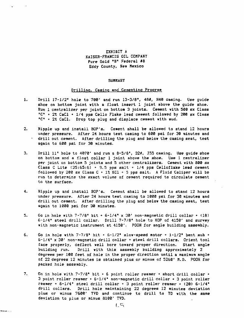
EXHIBIT A KAISER-FRANCIS OIL COMPANY Pure Gold "B" Federal #8 Eddy County, New Mexico
SUMMARY
Drilling. Casing and Cementing Program
Dr i l l 17-1/2" hole to 700' and run 13-3/8", 48#, H40 casing. Use guide shoe on bottom joint vith a float insert 1 joint above the guide shoe. Run 1 centralizer per joint on bottom 3 joints. Cement vith 500 sx Class "C" + 2% CaCl + 1/4 pps Cello Flake lead cement folloved by 200 sx Class "C" • 27. CaCl. Drop top plug and displace cement vith mud.
Nipple up and i n s t a l l BOP's. Cement shall be alloved to stand 12 hours under pressure. After 24 hours test casing to 800 psi for 30 minutes and d r i l l out cement. After drilling the plug and belov the casing seat, test again to 600 psi for 30 minutes.
Dr i l l 11" hole to 4070' and run a 8-5/8", 32#, J55 casing. Use guide shoe on bottom and a float collar 1 joint above the shoe. Use 1 centralizer per joint on bottom 5 joints and 5 other centralizers. Cement vith 800 sx Class C Lite (35:65:6) +9.5 pps salt + 1/4 pps Celloflake lead cement folloved by 200 sx Class C + 17, KC1 + 5 pps salt. A Fluid Caliper v i l l be run to determine the exact volume of cement required to circulate cement to the surface.
Nipple up and i n s t a l l BOP's. Cement shall be alloved to stand 12 hours under pressure. After 24 hours test casing to 1000 psi for 30 minutes and d r i l l out cement. After drilling the plug and belov the casing seat, test again to 1000 psi for 30 minutes.
Go in hole vith 7-7/6' bit • 6-1/4" x 30' non-magnetic d r i l l collar + (18) 6-1/4" steel d r i l l collar. D r i l l 7-7/8" hole to KOP of 4150' and survey vith non-magnetic instrument at 4150'. POOH for angle building assembly.
Go in hole vith 7-7/8" bit + 6-1/2" slov-speed motor + 1-1/2" bent sub • 6-1/4" x 30' non-magnetic d r i l l collar + steel d r i l l collars. Orient tool face properly, deflect veil bore tovard proper direction. Start angle building run. D r i l l vith this assembly building approximately 2 degrees per 100 feet of hole in the proper direction until a maximum angle of 22 degrees 12 minutes i s obtained plus or minus of 5260' M.D. POOH for packed hole assembly.
Go in hole vith 7-7/8" bit + 6 point roller reamer + short d r i l l collar • 3 point roller reamer + 6-1/4" non-magnetic d r i l l collar • 3 point roller reamer + 6-1/4" steel d r i l l collar • 3 point roller reamer + (20) 6-1/4" d r i l l collars. D r i l l hole maintaining 22 degrees 12 minutes deviation plus or minus 7600' TVD and continue to d r i l l to TD vith the same deviation to plus or minus 8100' TVD.
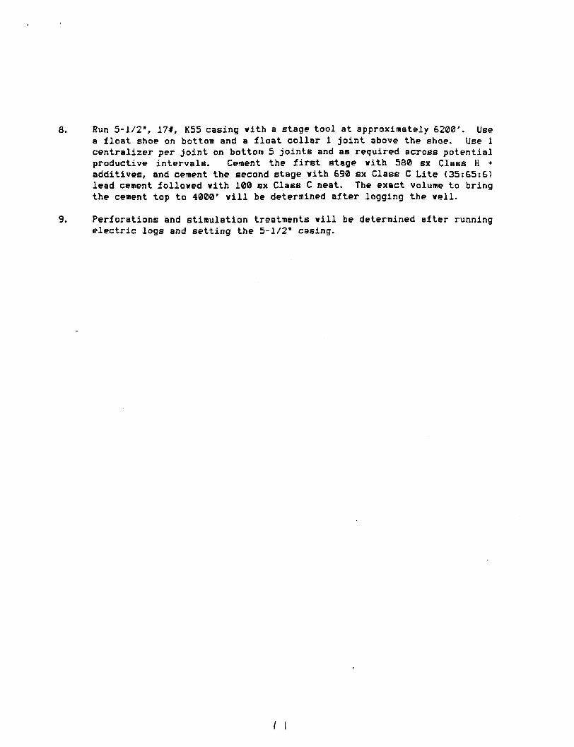
Run 5-1/2", 17#, K55 casing with a stage tool at approximately 6200'. Use a float shoe on bottom and a float collar 1 joint above the shoe. Use 1 centralizer per joint on bottom 5 joints and as required across potential productive intervals. Cement the f i r s t stage vith 580 sx Class H + additives, and cement the second stage vith 690 sx Class C Lite (35:65:6) lead cement folloved vith 100 sx Class C neat. The exact volume to bring the cement top to 4000' v i l l be determined after logging the veil.
Perforations and stimulation treatments v i l l be determined after running electric logs and setting the 5-1/2" casing.
/ (
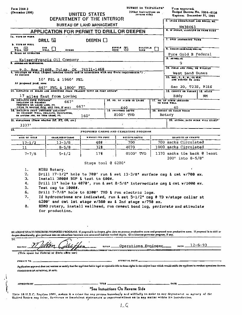
Form 3169 3
(December 1990) UNITED STATES
DEPARTMENT OF THE INTERIOR
SUBMIT m TIUPUCAT*;*
(Other Instructions on rcrerac aide)
Koi in a p p r o v e d .
Budget D u r e a u No . 1 0 0 4 - 0 1 3 6 E x p i r e e : D e c e m b e r 3 l , 1991
BUREAU OF LAND MANAGEMENT NM38463
APPLICATION FOR PERMIT TO DRILL OR DEEPEN 0. t r INDIAN, A L L O I T S S OS T S I S S K 1 S I
I*. T i n or WOIK
DRILL 153 DEEPEN • b. T i n or m i x
OIL r—i o»n r—1 aiNai.a tyi U I I L T I T L I I—1 W I L L LAI WSLL I 1 OTttsa zone UU zone 1 1
0. t r INDIAN, A L L O I T S S OS T S I S S K 1 S I
I*. T i n or WOIK
DRILL 153 DEEPEN • b. T i n or m i x
OIL r—i o»n r—1 aiNai.a tyi U I I L T I T L I I—1 W I L L LAI WSLL I 1 OTttsa zone UU zone 1 1
T. UNIT loassHsax Nina I*. T i n or WOIK
DRILL 153 DEEPEN • b. T i n or m i x
OIL r—i o»n r—1 aiNai.a tyi U I I L T I T L I I—1 W I L L LAI WSLL I 1 OTttsa zone UU zone 1 1 8. PAJLM OS L B A 9 HAMS, WULL HO.
P u r e G o l d B F e d e r a l 1. MAMS or orssaioa
K a i s e r - F r a n c i s O i l Company
8. PAJLM OS L B A 9 HAMS, WULL HO.
P u r e G o l d B F e d e r a l 1. MAMS or orssaioa
K a i s e r - F r a n c i s O i l Company 9 1. AooaanMamarinMHO.
P r>. Rnx 2 1 4 6 8 , T u l s a , OK 7 4 1 2 1 - 1 4 6 8
9 1. AooaanMamarinMHO.
P r>. Rnx 2 1 4 6 8 , T u l s a , OK 7 4 1 2 1 - 1 4 6 8 10. rtSLD AMD rooL, oa WILDCAT
West S a n d Dunes 4. LOCATION or W S L L (Report tocslloa dearly and la sccordaace with ear State requirements.•) . At surfsce
1 0 ' F S L fi I 9 6 0 1 F E L
At proposed prod, sooe
6 6 7 ' FNL & 1 8 0 0 ' F E L
10. rtSLD AMD rooL, oa WILDCAT
West S a n d Dunes 4. LOCATION or W S L L (Report tocslloa dearly and la sccordaace with ear State requirements.•) . At surfsce
1 0 ' F S L fi I 9 6 0 1 F E L
At proposed prod, sooe
6 6 7 ' FNL & 1 8 0 0 ' F E L
11. s s c , r.. a., H , oa S L S . AND s u s r s i oa ASSA
S e c 2 0 , T 2 3 S , R31E
\ 4 . O I R T A K C S III M I L S S AND D I S S C T 1 0 N T S O H H S A S S S T TOWN OS r O S T U N C I 1
17 m i l e s E a s t f rom L o v i r i g
12. COUNTI oa r is ian IS. STATS
Eddy NM
S . L S A S S DSSIUNATIOH AMD S S S I A L SO.
10. DIOTAHCS raou rsorusco* cait L O C A T I O N TO M I A S t S T O O / r t o r i s T i oa u e i s s u s e , rx . c , 7 , (Also to aearest drlg. unit line. If a n r ) 0 0 /
I s . o isTAMt- i '"non i-iot-oasa L O C A T I O N * " TO KCASSIT w t u „ O S I L L I N O , C U J I T L I T S O . os A r r u c s roa, en m i s L S A S S . r r . 160'
18. NO. or 1 I I I IN LSASS
MQ 10. I'KuiostD o c r r i i
8100' TVD
17. NO. o r Acssa A S S I O N S D TO T H I S W S L L
40 2 0 . S O T A S I OB C A S L S T O O L S
Rotary 21. staTATiONS (Show whether DF. KT, CR, etc.)
3337'
22. A r r s o s . D A T S woaa W I L L S T A I T *
23. PROPOSED CASINO AMD CEMKMT1NQ PROORAM
s u e or HOLS
17-1/2 11
7-7 /8
stzn or Grttitta
13-3/8 8-5/8
5-1/2
W C I O U T r e s roor
48# 321,
17tt
S I T T I N Q D t r T H
700 4070
8100' TVD
qUANTITI Or CIHIHT
700 sacks C i r c u l a t e d 1000 sacks C i r c u l a t e d
1370 sacks t i e back @ least 200' i n t o 8-5/8"
Stage t o o l @ 6200'
1. MIRU Rotary. 2. D r i l l 17-1/2" hole to 700' run & set 13-3/8" surface csg k cmt w/700 sx. 3. I n s t a l l 3000f BOP & t e s t t o 600#. 4. D r i l l 11" hole to 4070', run I set 8-5/8" intermediate csg & cmt w/1000 sx. 5. Test csg to 10001. 6. D r i l l 7-7/8" hole to 8100' TVD f. run e l e c t r i c logs. 7. I f hydrocarbons Bre indicated, run & set 5-1/2" csg 9 TD v/stage c o l l a r at
6200' and cmt 1st stage v/580 sx & 2nd stage v/790 sx. 8. RDM0 rotar y , i n s t a l l wellhead, run cement bond log, perforate and stimulate
f o r production.
IN A B O V E STACP. DP-SCRinC PROPOSED PROORAM: If propoial Ii lo deepen, give data on preienl productive zone and proposed new productive zone. If proposal Ii lo drill or deepen dlrccdonally, give pertinent data on lUiturface location! and meaiurcd and true vertical depth,. Oive blowout preventer program, if any.
TITI.S QDera-tiQns_En?jineex OATS — 1 2 - 6 - 9 3
( T h i s nimce for Federal or S t s t s ofUce usr )
rr.asnT xo ; AIM'KOI-AL DATB .
Application approval docs not warrant or certify lhat die applicant lioldi legal or equitable title lo l i n t riglfe In die luliject leate which would cnUlle lhe applicant lo conduct operatic™ Uierron.
coNoiTiotis or ArraovAi. if ANYI
ArrgovRo « r - U T L E D A H
*Scc Insliucliont On Rcvcitc Sid* T l t l r IH U . S . C . S e c t i o n 1001 , m a k e s l l a crl ini* for nny p r r s o n kiinwinp.ly nw l w i l l f u l l y In m n k r lo nny ' I r p n r t n o n l nr np.-n«-y nf III" U n l l n l S t a i r s nny f a l a r , l i r ' i t i m i s nr (rn.i i l i i lont s t a l c m o i i i a or r c p i c s e n l a t l o n s a s lo any mai le r w i th in ilr» )n r tMl i r l Inn .
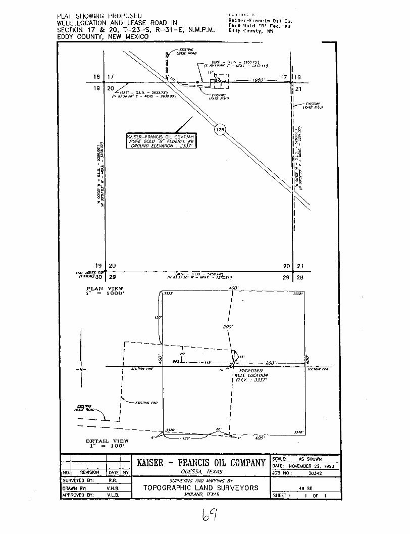
IJLAI bllUWING HKUPUbhU WELL .LOCATION AND LEASE ROAD IN SECTION 17 & 20, T -23 -S , R-31-E, N.M.P.M. EDDY COUNTY, NEW MEXICO
I . ; . I l l M I L I.
K a i s e r - F r a n c l n O H Co. Pure Gold "6" Fed. 19 Eilrfy County, KM
P L A N V I E W 1" = lOOCV
400' f\ 1333-
A
- N -
oasmc tost mv
- - J - _J
D E T A I L V I E W 1" = 10LV
200'
~1~ • 200'-
PROPOSED 'nru LOCATION
ELIV. : JJJ7'
srcnoM we
400'
KAISER - FRANCIS OIL COMPANY ODESSA, TEXAS
SCALE: AS SHOWN KAISER - FRANCIS OIL COMPANY ODESSA, TEXAS
DATE: NOVEMBER 22. 1993 NO. REVISION DATE BY
KAISER - FRANCIS OIL COMPANY ODESSA, TEXAS JOB NO.: 30312
SURVEYED BY: R.R. SURVEYING ANO MAPPING BY
TOPOGRAPHIC LAND SURVEYORS MIDLAND, TEXAS
48 SE DRAWN BY: V.H.B.
SURVEYING ANO MAPPING BY
TOPOGRAPHIC LAND SURVEYORS MIDLAND, TEXAS
48 SE APPROVE0 BY: V.L.B.
SURVEYING ANO MAPPING BY
TOPOGRAPHIC LAND SURVEYORS MIDLAND, TEXAS SHEET : 1 OF 1
Kaiser -Franc i s U i i Co. Pure Gold *B" Fed. #9 Eddy County, NM
VERTICAL PROJECTION SCALE 1" - 564*
S 12* 29' 38' E 4000
4250' KOP
KAISER-FRANCIS OIL COMPANY PURE GOLD " B " FIELD
SECTION 20, T 23 S-R 31 E. PROPOSED WELL NO. B-9
EDDY COUNTY. NEW MEXICO
HORIZONTAL PROJECTION SCALE i* - 169*
4500
UP at 2 00'
-150 SUR.oLOC
S E C . 17
150
S E C . 20
SURFACE LOCATION CALLS: 10* FSL -pSO.OO'FEL (SEC. 17)
5159' 18* li' {0)U° TARGET - 6200' TVO 480.00* FNL - 1800.00* FEL (SEC. 20) 490.00' SOUTH 12 29* 38" EAST PROPOSED B.H.L.- 8100* TVD
5144.17*
in
ro
rr-iuruiseu B.H.L,.- oiuu vu / / / / / / r W V / / / / / / / / / / / / / / / 666.95* FNL - 1800.00* FEL (SEC. Z * , U U U W t L U N L U % 693.37* S 12 29* 38" E OF SUR. LOCATION
6311* 18 11'
NOTE: HARDLINES ARE 100' NORTH ANO 150' EA9T OF TARGET,
DOWN at i" 30*
-150
•150
-300
co
6200.00' 450
^600
7430.40*
7430.40 7500
<> 7523* 0 00*
BHL
150 -750
8100.00 TVD 500
8193* 0 00'
1000
Submit lo tho Approprioto Owlrict Office Stofe Loon — 4 eopioe Fee LOOM - ' J copiet
D (STRICT I P. d. Box 1980 Hobbs. NM 88240
DISTRICT II P. 0. Drower DD Artesia, NM 88210
DISTRICT 111 1000 Rio Brazos Rd Aztec. NM 87410
Slate of New Mexico Energy, Minerals, and Natural Resources Department
OIL CONSERVATION DIVISION P. 0. Box 2088
Santa Fe. New Mexico 87504-2088
WELL LOCATION AND ACREAGE DEDICATION PLAT All distances must be from the outer boundaries of the section.
Form C-102 Reviled 1-1-89
Operator KAISER - FRANCIS OIL COMPANY
Leaae PURE: G O L D # B ' F E D E R A L
Veil No.
9 Unit Utter
0 SeeUon
17 TownabJp Range
23 SOUTH 31 EAST, N.M.P.M. County
EDDY Actual footage Location OC Veil
10 feet from the S O U T H Cround Loral Her.
3337*
line and 1960 feet from the EAST line Producing FormaUon
r)<»1 a w a r p
Pool
W. Sand Dunes 40 Aorei
1. Outline the ocreoge dedicoted to the subject well by colored pencil or hochure morks on the plot below. 2. If more than one leose is dedicoted to the well, outline eoch ond identify the ownership thereof (both as
to working interest ond royalty). 3. If more than one lease of different ownership is dedicoted to the well, hove the interest of all the owners
been consolidated by communitization, unitization, forced—oooling, etc.? Q Yes O No If answer is "yes", type of consolidation If the answer is "no", list the owners ond tract descriptions which have actually been consolidated. (Use the reverse side of this form if neccessary.) No allowable will be assigned to the well until all interests have been consolidated (by communitization, unitization, forced-pooling, or otherwise) or until a non—standard unit, eliminating 3uch interest, has been approved by the division.
1 1
Bottomhole Locationl: 667' FNL & 1? j00' FEL
I l The[acreage dedicated to t h i s well NW/j NE/4 Sec 20, TJ23S, R31E
[is the
! ! ^ 4— 1960'-
9 330 <S0 990 1320 ISM 14*0 »1tn le-an
OPERATOR CERTIFICATION / hereby certify that the
information herein is true and complete to the best of my know/edge and belief. Slenatui
Printed Name
Milton G r i f f i n PoiiUon
Operations Engineer Company
K a i g p r - F r a n r i t ; O i l C n . Oata
December 6, 1993
SURVEYOR CERTIFICATION / hereby certify that the
well location shown on this plat was plotted from field notes of actual surveys made by me or under my supervision, and that the same is true and correct to the best of my knowledge and belief.
Oata 3urrj>T*«V 4v. .;:>
'NOVEMtfER 22,.'1,963 Signature and.Seal of Profeaafoaal Jurreyor
EZNER S.P.S. JT7920
APPLICATIOH FOR PERMIT TO DRILL KAISER-FRAHCIS OIL COMPAHY Pure Gold Federal No. #9
Surface Locations 10' FSL & 1960* FEL Bottomhole Location: 667' FNL & 1800' FEL
Eddy County, New Mexico
In conjunction with Form 3160-3, Application for Permit to D r i l l , Kaiser-Francis Oil Company submits the following items of pertinent information in accordance vith Onshore Oil & Gas Order Nos. 1 & 2, and with a l l other applicable federal and state regulations.
1. The geologic surface formation i s Quaternary alluvium and other surfic i a l deposits.
2. The estimated tops of geologic markers are as follows:
Delaware 4150' Bone Springs 8000' TD 8100'
3. We do not anticipate encountering water, and o i l and gas formations are as follows:
Delaware
4. Proposed Casing Program: See Form 3160-3 and Exhibit A.
5. Pressure Control Equipment: See Exhibit B.
6. Mud Program: See Exhibit C.
7. Auxiliary equipment: Blowout preventer.
8. Testing, Logging, and Coring Programs: No DST's are anticipated. Approximately 25 rotary drilled Bidevall wireline cores will be taken in various Delavare zones between 5900' to 7900'. Electric logs will consist of a Compensated Neutron/Litho Density w/Gamma Ray and Caliper and a Dual Laterolog. A Mudlogging unit will be used from 4150' to TD.
9. No abnormal pressures, no abnormal temperatures and no H2S are expected.
10. Anticipated starting date: As soon as possible.
EXHIBIT A KAISER-FRANCIS OIL COUPANY Pure Gold "B" Federal #9 Eddy County, Nev Mexico
SUMMARY
Drilling. Casing and Cementing Program
1. D r i l l 17-1/2" hole to 700' and run 13-3/8\ 48#, H40 casing. Use guide shoe on bottom joint vith a float insert 1 joint above the guide shoe. Run 1 centralizer- per joint on hottam 3 joints^ Cement vith 500 sx Class "C" • 27. CaCl • 1/4 pps Cello Flake lead cement folloved by 200 sx CIBSS "C" + 27. CaCl. Drop top plug and displace cement vith mud.
2. Nipple up and in s t a l l BOP's. Cement shall be alloved to stand 12 hours under pressure. After 24 hours test casing to 600 psi for 30 minutes and d r i l l out cement. After drilling the plug and belov the casing seat, test again to 600 psi for 30 minutes.
3. D r i l l 11" hole to 4070' and run a 8-5/8", 32#, J55 casing. Use guide shoe on bottom and a float collar 1 joint above the shoe. Use 1 centralizer per joint on bottom 5 joints and 5 other centralizers. Cement vith 800 sx Class C Lite (35:65:6) +9.5 pps salt + 1/4 pps Celloflake lead cement folloved by 200 sx Class C + IX KC1 + 5 pps salt. A Fluid Caliper v i l l be run to determine the exact volume of cement required to circulate cement to the surface.
4. Nipple up and in s t a l l BOP's. Cement shall be alloved to stand 12 hours under pressure. After 24 hours test casing to 1000 psi for 30 minutes and d r i l l out cement. After drilling the plug and belov the casing seat, test again to 1000 psi for 30 minutes.
5. Go in hole vith 7-7/8" bit + 6-1/4" x 30' non-magnetic d r i l l collar • (18) 6-1/4" steel d r i l l collar. D r i l l 7-7/8" hole to KOP of 4250' and survey vith non-magnetic instrument at 4250'. POOH for angle building assembly.
6. Go in hole vith 7-7/8" bit • 6-1/2" slov-speed motor • 1-1/2" bent sub • 6-1/4" x 30' non-magnetic d r i l l collar • 20 steel d r i l l collars. Orient tool face properly, deflect veil bore tovard proper direction. Start angle building run. D r i l l vith this assembly building approximately 2 degrees per 100 feet of hole in the proper direction until a maximum angle of 18 degrees 11 minutes i s obtained plus or minus to 6311' M.D. POOH for angle dropping assembly.
7. Go in hole vith 7-7/8" bit + 6-1/4" non-mag d r i l l collar + 3 point roller reamer + 6-1/4" steel d r i l l collar + 3 point roller reamer • (20) 6-1/4" d r i l l collars. D r i l l hole dropping at 1.5 degrees per 100' to the TVD depth of 7430.40' at this point you v i l l be vertical and v i l l continue to d r i l l to a TVD depth of 8100'.
n i
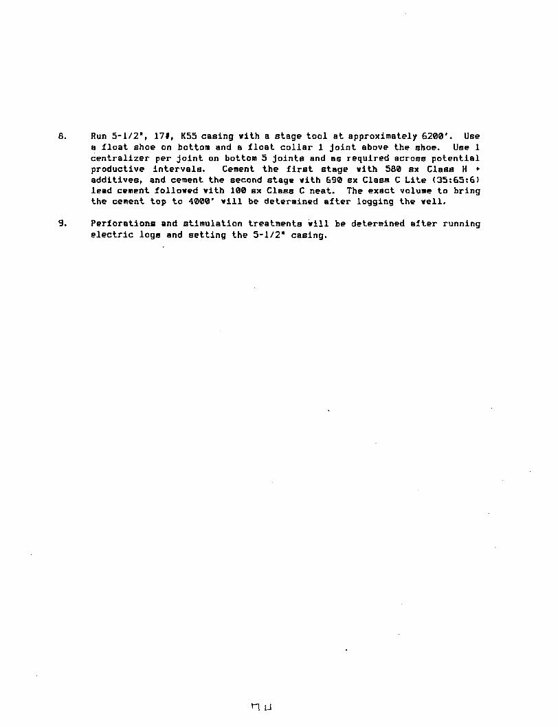
8. Run 5-1/2", 17#, K55 casing with a stage tool at approximately 6200'. Use a float shoe on bottom and a float collar 1 joint above the shoe. Use 1 centralizer per joint on bottom 5 joints and as required across potential productive intervals. Cement the f i r s t stage with 560 sx Class H * additives, and cement the second stage with 690 sx Class C Lite (35:65:6) lead cement followed with 100 sx Class C neat. The exact volume to bring the cement top to 4000' will be determined after logging the well.
9. Perforations and stimulation treatments will be determined after running electric logs and setting the 5-1/2" casing.
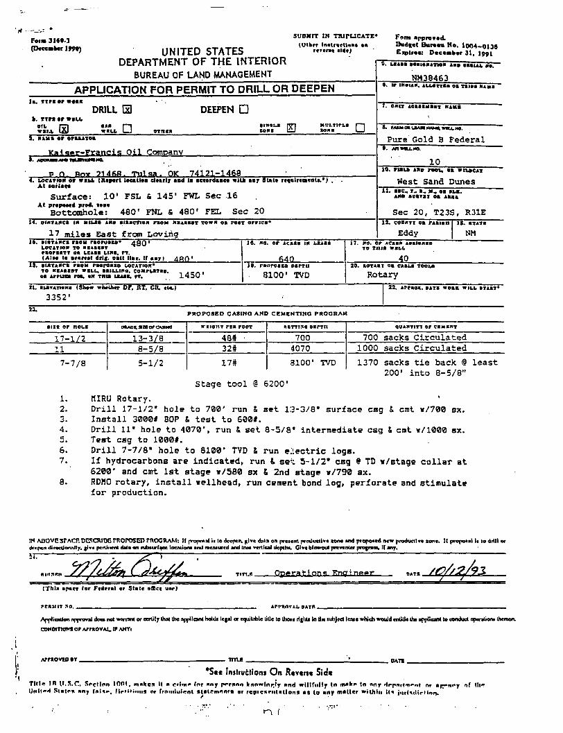
' f t - - - . : *
Foia 3169.3 (Deccabcr 1990) UNITED STATES
DEPARTMENT OF THE INTERIOR BUREAU OF LAND MANAGEMENT
SUBMIT IK TTUTUCATE* (Utbtr Inatfarttna*
rcrerst aide!
Form approved. Bud«et Bureau No. 1004-0136 Expiree: Oaeaoibar 31, 1091
6. LXl
NM38463 APPLICATION FOR PERMIT TO DRILL OR DEEPEN 0. ir IKOUK, ALLOTTI
la . T i r a ar woe* DRILL Ei DEEPEN • 1. oarr Maaastaa-x K I K I
I. T i ra or w i n .
,x GO OIL rai.i
0 « * w t u . • •INOLa
tone IS Miii.rlrLa tout •
1. tuna er oraajkioa
K»,i«t.ir-Francis O i l Company
Pure Gold B Federal t . AI1WBU.MO.
J . w n a i / i e 10 p n R O Y 7 1 4 f i f l . T u l s a . OK 7 4 1 2 1 - 1 4 6 8
4. LOCATION or wiu> (Report lecatlea dearly aad la aeeordaace wllb aay State reeulrenjeota.*) At eorlaee
S u r f a c e : 10' FSL & 145" FWL Sec 16 At prepeeed prod, teae
Bottomhole: 480' FNL & 480' F E L Sec 20
19. r i a u l a s raou, oa WILDCAT
West Sand Dunes 11. e * c T_ a , «t, oa E L * ,
AHO auarax oa aaaa
Sec 20, T23S, R31E
rr DiflTAKCi IN m u i Aaa oiaacTioM raoM MaABaar TOWN oa rear orrica* 12. COOKTI oa rAlien
i 7 miles East from Loving Eddy la . oioTAMca raoH r s o r u e a e * 4 8 0 '
LOCATiox TO aeaeear raonarr oa Leaae LIMB, rr . (Alae te aearcel drlg. aalt llae. If «»r) 4 f l 0 '
13. oi«TAHC«"faoM raoroaao LOCATION* TO HCAaerr WELL. BaiLLtno. coMrLarao. , A am oa Arruta roa. en tnta Leaae, rr. 1 4 3 0
11. OTA Ye
NM IS. no. or acaae in LBAae
64Q IV. rnnroaco psrrii
8100' TVD
17. HO. or Acaae taalonao TO Tina WELL
40 20. aoTAar oa CABLE TOO La
Rotary 21. iLBTATtene (Show whether Or. ItT, CH. tie.)
3352' 22. Arraoi. DATE woaa WILL aiAai*
23. PROPOSED CASINO AND CEMENT! N.Q PROGRAM
• izr or noLi
17-1/2 11
7-7/8
eaAoa aiaorouiNO
13-3/8 8-5/8
5-1/2
aeioiiT rea r o d
48# 32#
17#
aarri.10 » i n n
700 4070
3100' TVD
qOAHTITT or CEMENT
700 sacks Circulated 1000 sacks Circulated
1370 sacks t i e back @ least 200' i n t o 8-5/8"
Stage t o o l § 6200'
1. HIRU Rotary. 2. D r i l l 17-1/2" hole to 700' run & set 13-3/8" surface csg & cmt v/700 sx. 3. I n s t a l l 3000* BOP & t e s t to 600*. 4. D r i l l 11" hole to 4070', run & set 8-5/8" intermediate csg & cmt v/1000 sx. 5. Test csg to 1000*. 6. D r i l l 7-7/8" hole to 8100' TVD & run e l e c t r i c logs. 7. I f hydrocarbons are indicated, run & set 5-1/2" csg 9 TD v/stage collar at
6200' and cmt 1st stage »/580 sx & 2nd stage Y/790 sx. 8. RDW0 rotary, i n s t a l l nellhead, run cement bond log, perforate and stimulate
f o r production.
IM ABOVE SF ACT. DlvSCJUDB NtOrOSED rttOGRAM: If rvopoal ii to deepen, give data on preterit productive zone and proposed new productive tone. II proposal I. to drill or deepen direcdonally, give pertinent data en subsurface locations and measured and true vertical depths, Oive blowout preventer proaraev If any.
TiTt.r. O p e r a t i f i n c Rnqri n s o r DATE
(Thla apace tor Federal er Stele office uer)
" » " " *" ArraoTAL OATB .
Application approval doe* not warrant or certify that the applicant hoi ill legal or equitable title to llnsi rlglxs lo llae subject lease which would entitle the applicant lo conduct cperationa thereon.
CONDITIONS or ArmovAX. ir ANYI
AWtOVCD BY TITLE ' DATS
*Ste Initrucliom On Rtvtrjc Sid** TIM* IW U . S . C Section 1001. mattea It » crime for any person Irnnvrlnp.'y nnd willfully In make tn any HrpnrlTfnt nr »r/"nry nf III" Unll»H Stair* any falae, f lnl ' i .n is or [rnnilulcnl Etalrmirnta or repic5rntatlorH as to any mailer within It* jmivl ir fInn.
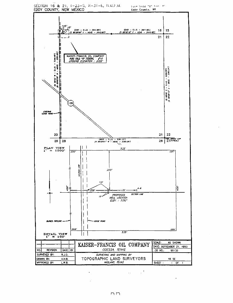
SECIION 16 & 2 1 . I - 2 J - S , K - J I - L , N.M.I'.M. EDDY COUNTY, NEW MEXICO
1 u i «? l i i i l d ' 1 ) ' I <"'•
Eddy County, Hit
(EAST - G.LO. - Jeti.as)
KAISER-FRANCIS OIL COMPANY
em COLD '»' roan fw GROUND ELEVATION : JJ52'
(CAST - OLO. - J««t ,»V) 1 g
ersiic" c - uas. - ins.or)
P L A N V I E W 1" — l O O O '
Bunco prone-
D E T A I L . V I E W 1" = l O O '
(W£5T - G.LO. - 5281.32") (M t r S f V I ' W - UCAS. - 32U20-)
XX
535'
200'
^200'
PROPOSED HELL LOCATION ELEV. : JJ52'
\ - L
535'
21
21
28
15
22
tt
31
22
27mrKAi)
KAISER-FRANCIS OIL COMPANY ODESSA. TEXAS
SCALE: AS SHOWN KAISER-FRANCIS OIL COMPANY
ODESSA. TEXAS DATE: SEPTEMBER 21. I99.J
NO. REVISION DATE BY
KAISER-FRANCIS OIL COMPANY ODESSA. TEXAS .08 NO.: 99130
SURVEYED BY: R.J.O. SURVEYING AND MAPPING BY
TOPOGRAPHIC LAND SURVEYORS MIDLAND, TEXAS
*B SE DRAWN BY: V.H.B.
SURVEYING AND MAPPING BY
TOPOGRAPHIC LAND SURVEYORS MIDLAND, TEXAS
*B SE APPROVED BY: L.W.B.
SURVEYING AND MAPPING BY
TOPOGRAPHIC LAND SURVEYORS MIDLAND, TEXAS SHEET : 1 OF t
n n
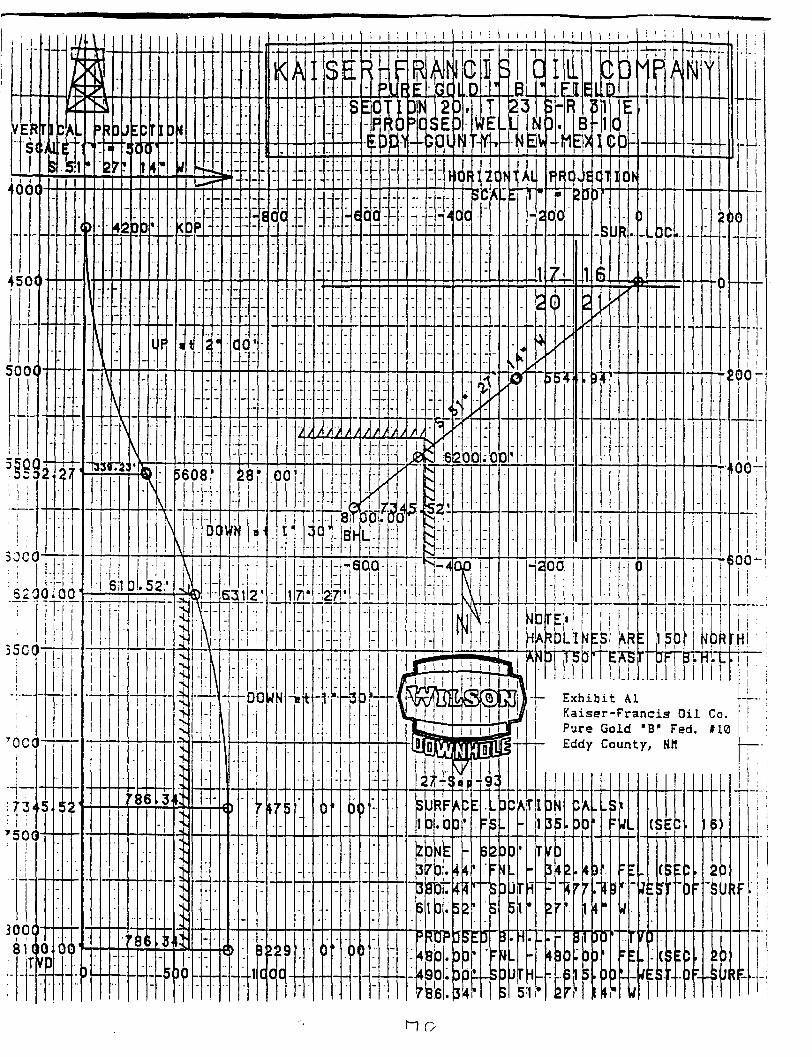
n o
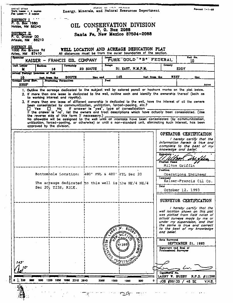
UlStlK.1 Ul lK.« State Laat* — 4 coptei /aa Laaaw*- 3 copies
DISTRICT I * * P. 0. Box 1980 Hobbs. NM 88240
DISTRICT II P. 0. Drower DO Artesia. NM 88210
DISTRICT 01 1000 Rio Brazos Rd Aztec. NM 87410
Encrgj, Minerals, end Natural Resources Department
OIL CONSERVATION DIVISION P. 0. Box 2088
Santa Fe, New Mexico 87504-2088
WELL LOCATION AND ACREAGE DEDICATION PLAT All distances must be from the outer boundaries of the section.
Revntd 1-1 -89
Operate* KAISER - FRANCIS OIL COMPANY pURfeTGOLD"» B- FEDERAL
tail Ne.
10 Unit SaeUaa
16 Teemahip Rasaa
23 SOUTH 31. EAST. NJi.P.M. County
EDDY Actual FetetUaej LaeeUeet af WeU
10 teat free* tha SOUTH Mae aad 145 feet from Uie WEST line Gretna Laval Be*.
3352' Pre4t>eiB« r« Fool
Acres
1. Outfine the ocreoge dedicoted to the subject well by colored pencil or hachure morks on the plat below. 2. If more than one lease is dedicated to the well, outline each and identify the ownership thereof (both as
to working interest ond royalty). 3. If more than one lease of different ownership is dedicoted to the well, have the interest of all the owners
been consolidated by communitization, unitization, forced—pooling, etc? O Yes • No If answer is "yes", type of consolidation If the answer is "no", list the owners and troct descriptions which have actually been consolidated. (Use the reverse side of this form if neccessary.) No allowable will be assigned to the well until all interests have been consolidated (by communitization, unitization, forced—pooling, or otherwise) or until a non-standard unit, eliminating such interest, hos been approved by the division.
Bottcmnole Location:
The ac. Sec 20
145'
eage dedicated T23S, R31E.
1480" FNL & 480' iFEL Sec 20
}to th i s well i s 'the NE/4 NE/4
330 MO (90 1330 1SS0 1980 2310 2640 2000 1500 1000 SOO
OPERATOR CERTIFICATION / hereby certify that the
information herein is true and complete to the best of my knowledge and belief.
PoelUoB Operations Enaineer
Company Kaiser-Francis O i l Co.
Data October 12, 1993
SURVEYOR CERTIFICATION
/ hereby certify that the well location shown on this, plat was plotted from field notes of actual surveys made by me or under my supervision, and that the same is true ond correct to the best of my knowledge and belief.
Date Surreyea SEPTEMBER 21, 19S3
Slfnature and Seal of Professional Surveyor
CejUsrcaTTNo. LARRY W. BUSBY R.P.S. #11396
JOB |99130 / 48 SE V.H.B.
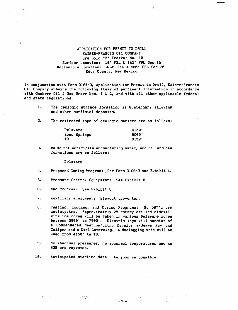
APPLICATION FOR PERMIT TO DRILL KAISER-FRANCIS OIL COMPANY Pure Gold "B" Federal No. 10
Surface Location: 10' FSL & 145' FWL Sec 16 Bottomhole Location: 480' FNL & 480' FEL Sec 20
Eddy County, Nev Mexico
In conjunction vith Form 3160-3, Application .for Permit to Drill, Kaiser-Francis Oil Company submits the following items of pertinent information in accordance vith Onshore Oil & Gas Order Nos. 1 & 2, and vith a l l other applicable federal and state regulations.
1. The geologic surface formation i s Quaternary alluvium and other surficial deposits.
2. The estimated tops of geologic markers are as follovs:
Delavare 4150' Bone Springs 8000' TD 8100'
3. We do not anticipate encountering vater, and oil and gas formations are as follovs:
Delavare
4. Proposed Casing Program: .See Form 3160-3 and Exhibit A.
5. Pressure Control Equipment: See Exhibit B.
6. Mud Program: See Exhibit C.
7. Auxiliary equipment: Blovout preventer.
8. Testing, Logging, and Coring Programs: No DST's are anticipated. Approximately 25 rotary drilled sidevall vireline cores v i l l be taken in various Delavare zones betveen 5900* to 7900'. Electric logs v i l l consist of a Compensated Neutron/Litho Density v/Gamma Ray and Caliper and a Dual Laterolog. A Mudlogging unit v i l l be used from 4150' to TD.
9. No abnormal pressures, no abnormal temperatures and no H2S are expected.
10. Anticipated starting date: As soon as possible.
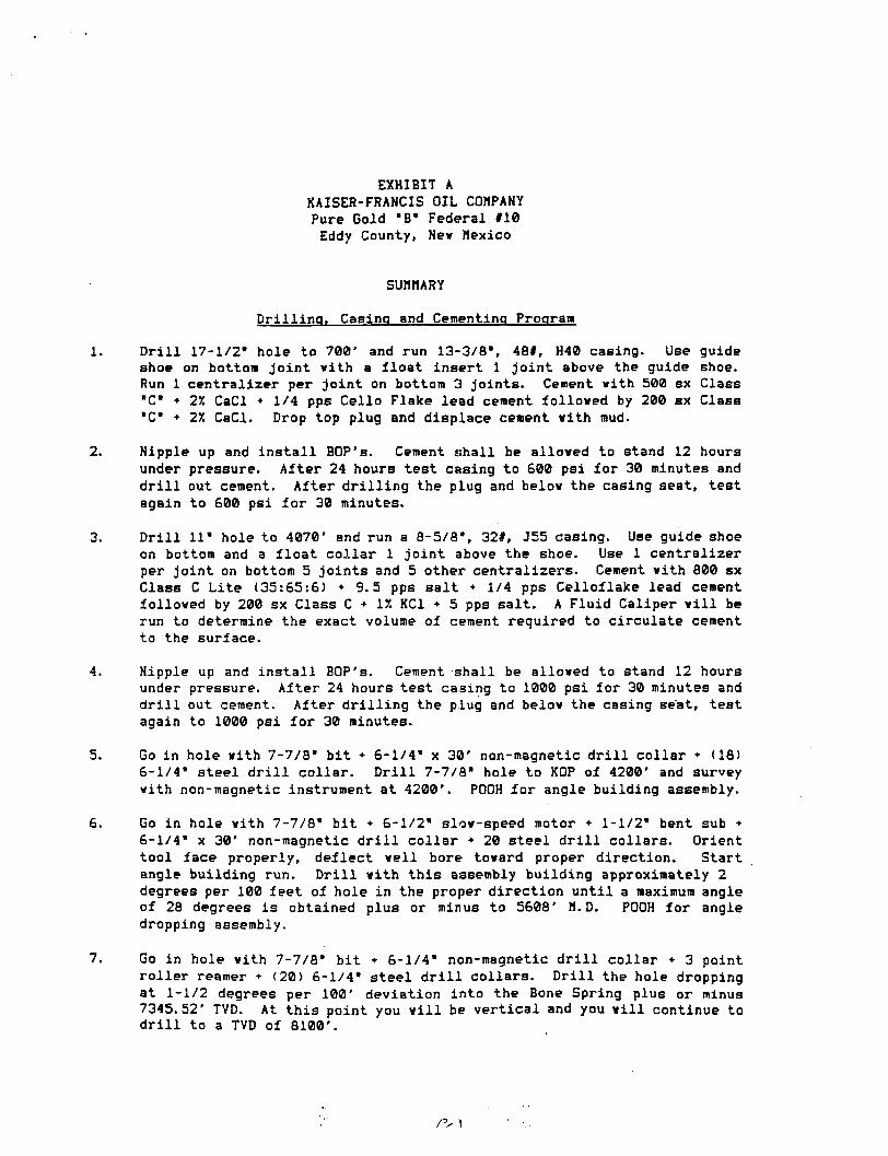
EXHIBIT A KAISER-FRANCIS OIL COMPANY Pure Gold "B" Federal #10 Eddy County, Nev Mexico
SUMMARY
Drilling. Casing and Cementing Program
1. Drill 17-1/2" hole to 700' and run 13-3/8", 48#, H40 casing. Use guide shoe on bottom joint vith a float insert 1 joint above the guide shoe. Run 1 centralizer per joint on bottom 3 joints. Cement vith 500 sx Class "C" • 27. CaCl • 1/4 pps Cello Flake lead cement folloved by 200 sx Class "C" • 27. CaCl. Drop top plug and displace cement vith mud.
2. Nipple up and install BOP's. Cement shall be alloved to stand 12 hours under pressure. After 24 hours test casing to 600 psi for 30 minutes and d r i l l out cement. After drilling the plug and belov the casing seat, test again to 600 psi for 30 minutes.
3. Drill 11" hole to 4070' and run a 8-5/8", 32#, J55 casing. Use guide shoe on bottom and a float collar 1 joint above the shoe. Use 1 centralizer per joint on bottom 5 joints and 5 other centralizers. Cement vith 800 sx Class C Lite (35:65:6) + 9.5 pps salt • 1/4 pps Celloflake lead cement folloved by 200 sx Class C + IX KC1 • 5 pps salt. A Fluid Caliper v i l l be run to determine the exact volume of cement required to circulate cement to the surface.
4. Nipple up and install BOP's. Cement shall be alloved to stand 12 hours under pressure. After 24 hours test casing to 1000 psi for 30 minutes and d r i l l out cement. After drilling the piug and belov the casing seat, test again to 1000 psi for 30 minutes.
5. Go in hole vith 7-7/8" bit • 6-1/4" x 30' non-magnetic d r i l l collar + (18) 6-1/4" steel d r i l l collar. D r i l l 7-7/8" hole to KOP of 4200' and survey vith non-magnetic instrument at 4200'. POOH for angle building assembly.
6. Go in hole vith 7-7/8" bit + 6-1/2" slov-speed motor • 1-1/2" bent sub • 6-1/4" x 30' non-magnetic d r i l l collar • 20 steel d r i l l collars. Orient tool face properly, deflect veil bore tovard proper direction. Start angle building run. Dr i l l vith this assembly building approximately 2 degrees per 100 feet of hole in the proper direction until a maximum angle of 28 degrees i s obtained plus or minus to 5608' H.D. POOH for angle dropping assembly.
7. Go in hole vith 7-7/8" bit • 6-1/4" non-magnetic d r i l l collar • 3 point roller reamer • (20) 6-1/4" steel d r i l l collars. Drill the hole dropping at 1-1/2 degrees per 100' deviation into the Bone Spring plus or minus 7345.52' TVD. At this point you v i l l be vertical and you v i l l continue to d r i l l to a TVD of 8100'.
/V I
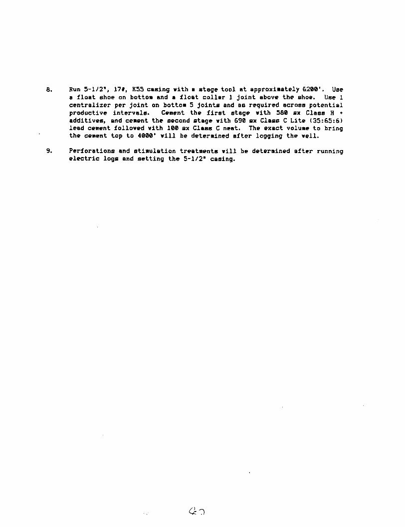
Run 5-1/2*, 17*, K55 casing vith a stage tool at approximately 6200'. Use a float shoe on bottom and a float collar 1 joint above the shoe. Use 1 centralizer per joint on bottom 5 joints and as required across potential productive intervals. Cement the f i r s t stage vith 580 sx Class H • additives, and cement the second stage vith 690 sx Class C Lite (35:65:6) lead cement folloved vith 100 sx Class C neat. The exact volume to bring the cement top to 4000' v i l l be determined after logging the veil.
Perforations and stimulation treatments v i l l be determined after running electric logs and setting the 5-1/2* casing.