kahikinui - department of hawaiian home lands · hawaiian homes commission hawaiian homes...
TRANSCRIPT

July 2011
KAHIKINUI
Regional Plan

KAHIKINUI

KAHIKINUI
Mailing Address:P.O. Box 1879
Honolulu, Hawaiÿi 96805
Planning OfficeTelephone: (808) 620-9480Facsimile: (808) 620-9559
Department of Hawaiian Home LandsAlbert “Alapaki” Nahale-a
ChairmanHawaiian Homes Commission
HAWAIIAN HOMES COMMISSIONIan Lee Loy (East Hawaiÿi)
Leimana K. DaMate (West Hawaiÿi)Perry O. Artates (Maui)
Henry Tancayo (Molokaÿi)Michael P. Kahikina (Oÿahu)
Jeremy Kamakaneoaloha “Kama” Hopkins (Oÿahu)Renwick V.I. Tassill (Oÿahu)Imaikalani P. Aiu (Kauaÿi)
Michelle KauhaneDeputy Director
M. Wai’ale’ale SarsonaChief-of-Staff
DEPARTMENT OF HAWAIIAN HOME LANDSHale Kalanianaÿole
91-5420 Kapolei ParkwayKapolei, Hawaiÿi 96707
www.hawaii.gov/dhhl
Chairman’s OfficeTelephone: (808) 620-9500Facsimile: (808) 620-9599
I. Introduction Regional Plan Goals & Process 1-2Partnering Benefits 3-4
II. Kahikinui General Description 5-6History & Culture 7-8Beneficiary Proposal for Homestead Development - Vision & Concept 9DHHL Proposed Land Use Designations 10Hawaiian Home Lands - Kahikinui Today 11Community Leaders & Stakeholders 12Elected & Appointed Officials 13Political Boundaries 14
III. Regional Land & Development Development Project Characteristics & Trends 15-16Land Ownership 17-18Natural & Cultural Resources 19-20
IV. Infrastructure Water 21-22Drainage 23Wastewater & Solid Waste 24Transportation: Transit, Roads, & Access 25-26Public Facilities 27-28Energy 29-30Community Wildfire Protection Plan 31-32
V. Homestead Issues & Priorities Issues & Opportunities 33Priority Projects 34-41
Contact Information 42
Contents

� KAHIKINUI
I. Introduction - Regional Plan Goals & ProcessThe mission of the Department of Hawaiian Home Lands (DHHL) is to effectively manage the Hawaiian Home Lands Trust and to develop and deliver lands to native Hawaiians. To accomplish this, DHHL works in partnership with government agencies, private landowners, non-profit organizations, homestead associations, and other community groups. Regional plans provide the means to solidify visions and partnerships that are essential to effectively manage Hawaiian Home Lands trust lands for the betterment of native Hawaiian beneficiaries.
This regional plan is one of twenty (20) regional plans that DHHL is developing statewide. Kahikinui is one of the regions on Maui that have been selected for regional planning. In these regional plans, DHHL takes on a leadership role in the region, working to strengthen the growth of the area, developing partnerships to leverage diverse resources and capital investment; and fostering beneficiary participation in determining the future direction of the homestead community. The regional plans provide the Department and the affected homestead community opportunities to assess land use development factors, identify issues and opportunities, and identify the region’s top priority projects slated for implementation within the next three (3) years.
What are Regional Plans?
Regional Plans are part of DHHL’s 3-tiered Planning System (see figure to right). At tier one is the General Plan which articulates long-range Goals and Objectives for the Department. At the second tier, there are Program Plans that are statewide in focus, covering specific topic areas such as the Native Hawaiian Housing Plan and a Native Hawaiian Development Program Plan. Also at this second tier are the Department’s Island Plans that identify the Department’s Land Use Designations per island which function similar to the counties’ land use zones. The regional plans are located at the third tier in the Department’s planning system which focuses at the community/regional level. The regional plans apply the goals, policies, and land use designations to specific geographic regions. The regional plans are a means to:
Identify data -- people, lands, and infrastructure of homestead communities and the surrounding region;Identify what DHHL and other landowners are planning to do;Provide the primary mechanism for beneficiary input in the development of their homestead communities;Identify issues and potential projects; and Identify Priority Projects determined by the Department and homestead community.
•
••
••
REGIONAL PLANSHomestead areas,
1-3 year time frame
GENERAL PLANStatewide, 20-year time frame
STRATEGIC PROGRAM PLANS
Statewide, 3-6 year time frame
ISLAND PLANSGeographic, 10-year time frame
1st Tier
2nd Tier
3rd Tier

KAHIKINUI �
How are Regional Plans Developed?
The regional plans are developed in conjunction with lessees of the region as well as regional stakeholders (landowners, agencies, other organizations) in a series of planning meetings as illustrated in the figure below. During these meetings, issues and opportunities that should be addressed in the regional plan are identified and a list of potential projects is developed to address those issues and opportunities. From this list lessees determine by consensus, their top five (5) priority projects that are written up with project details, budget estimates, and other pertinent project planning information. Draft regional plans are then subject to the approval of the Hawaiian Homes Commission, which means that the Commission and Department officially support the priorities identified in the regional plan.
Upon approval, the homestead community, the Department, and other development partners can seek necessary funding and pursue the implementation of the Priority Projects. Priority Projects are key components for aligning support and providing focus to efforts to develop the region. Finally, since DHHL knows that regional development is a dynamic process with constantly changing opportunities and emerging issues, regular regional plan updates are built into the planning process. In this way, regional plans are updated as needed, which generally have amounted to biennial updates (one update every two years), in order to keep abreast of changing conditions and new opportunities.
How are Regional Plans Used?
As a compilation of existing plans and proposed projects for the region, the regional plan helps to coordinate the orderly development of regional infrastructure improvements. With the addition of lessee input in the process, the regional plans become a powerful tool to focus energies and efforts, align interests, and secure funding for the top priorities identified in the regional plan. In this way, regional plans have become a critical tool to unify and support our beneficiary community.
Figure 2: The Regional Plan Development and Update Process
Gather Data Conduct Planning Meetings
Identify Potential Projects
Identify Priority Projects
BiennialUpdates
HHCApproval
ImplementProjects
• Interview Agencies • Interview Landowners • Demographic Data • Development Trends • Legislation • Funding
• Homestead Leaders • Beneficiaries/Lessees • Surrounding Landowners • Government Agencies • Community Organizations
Beneficiary Community
Introduction - Regional Plan Goals & Process
� KAHIKINUI
Partnering BenefitsBenefits Of Partnering
DHHL is working in partnership with other government agencies, the private sector, and community organizations throughout the Sateo develop its lands and improve community life. DHHL believes that partnerships are generally an effective way to leverage resources and capital investments, mitigate undesirable impacts of development, coordinate area growth, reduce risks in large-scale community projects, and create broad community benefits.
These partnerships allow for better prioritization and coordination of infrastructure improvement and the development of regional public and residential facilities. This coordination helps individual organizations achieve their goals while bringing long-term benefits to the community and region.
DHHL brings to these partnerships:Land for development in strategic locationsPotential use of tax-exempt financingAccess to legislative appropriationsAccess to federal funding such as HUD, USDA, SBAFlexibility in the application of development standards, zoning, and designCultural understanding and resources
Successful Partnerships
Residential PartnershipsThrough partnerships DHHL has reduced the cost of homes to low-income beneficiaries. DHHL has done this by sharing in the cost of infrastructure, helping to secure tax credits, and using self-help methods of construction. Partnerships in Kapolei resulted in 70 Rent-to-Own units constructed by Mark Development using low-income tax credits and 45 self-help homes constructed with Menehune Development and Honolulu Habitat for Humanity. In these types of partnerships, DHHL often provides the land, secures federal grants, and provides access to, or assistance in, acquiring tax credits, subsidies, or other financing.
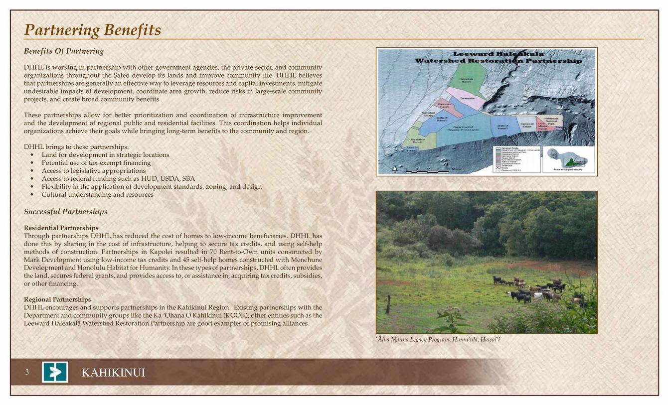
Regional PartnershipsDHHL encourages and supports partnerships in the Kahikinui Region. Existing partnerships with the Department and community groups like the Ka ÿOhana O Kahikinui (KOOK), other entities such as the Leeward Haleakalä Watershed Restoration Partnership are good examples of promising alliances.
••••••
`Äina Mauna Legacy Program, Humuÿula, Hawaiÿi

KAHIKINUI �
Partnering BenefitsInfrastructure PartnershipsDHHL has partnered with county governments and utility providers on infrastructure improvements that benefit the entire community. DHHL has participated in water system development with the counties by providing funding, land easements, and access to federal and state programs. Examples include the extension of the Lower Kula Water System on Maui, the Waimea Irrigation System, the Makuÿu Water System on Hawaiÿi, and the Waiawa-Waipahu water system on Oÿahu. DHHL water systems at Anahola on Kauaÿi, and Ho‘olehua on Molokaÿi are interconnected with nearby County water systems providing both parties backup source and storage capacity in the event of emergencies. DHHL has also provided numerous easements over its lands to electrical, water, telephone, and cable companies to service both homestead areas and the general public.
Public Facilities PartnershipsDHHL has participated in a number of partnerships involving public facilities and community resources. The most notable partnerships have brought together Hawaiian agencies and non-profit organizations into a multi-service complex where a broad range of programs are housed to serve the public. Such multi-service complexes have been built on Hawaiian Home Lands in partnership with Kamehameha Schools, Queen Liliÿuokalani Children’s Center, Alu Like, Papa Ola Lökahi, the Office of Hawaiian Affairs, Hawaiian community organizations, and the counties. These multi-service complexes house preschools, offices, meeting facilities, health clinics, and activity centers. For example, the Paukükalo homestead on Maui is served by a County park on DHHL land next to a community hall, the DHHL district office, the Hawaiian Community Assets’ home ownership counseling center, and a Kamehameha Schools preschool. DHHL, private businesses, government agencies, and private foundations have joined together to provide materials for playgrounds constructed by homestead associations and other community volunteers.
Natural Resource Management PartnershipsThrough a series of management partnerships with DLNR, the Nature Conservancy’s Honouliuli Preserve, and other property owners, unique ecosystems and historic sites are being protected. For example, DHHL is partnering with DLNR to protect the red ÿilima (abutilon) in East Kapolei. Other examples include the Hakalau Forest Reserve, the ÿÄina Hou Management Area, the Päläÿau and Moÿomomi preserves, the Kalaupapa peninsula, and the Kamäÿoa-Puÿuÿeo National Historic District where koa forests, endangered plants and animals, and native species are being protected for future generations. Beachfront recreational values are protected through management agreements with the City and County of Honolulu for Makapuÿu, Kaiona, Kaupö, Waimänalo, and Nänäkuli beach parks.
DHHL has an eradication program partnership to remove the alien Gorse species in Kahikinui, Maui. The homestead community should be included in the partnerships with DHHL to assist with eradication of Gorse while it is still manageable in Kahikinui.
Forest enclosures to protect endangered ecosystems
Gorse eradication

� KAHIKINUI
II. Kahikinui - General DescriptionKahikinui Maui County State U.S.
Total population 32 141,698 1,227,008 --Median age (years) 41.0 38 38 35.3
Housing Characteristics
Total Housing Units 20 64,936* 482,873 --Occupied Units 13 48,848 251,808 66.2Home ownership rate 100% -- -- --
Average household size 3.0 2.91 -- --
*2006-2008 U.S. Census Bureau, State & County QuickFacts, **1999 U.S. Census Bureau, State & County QuickFactsSource: DBEDT, Profile of General Demographic Characteristics: 2000 Geographic Area: Kahikinui Home Land, HI
Kahikinui was traditionally part of a larger moku that contained the present DHHL homestead area and some additional neighboring ahupua’a from Kanaio to Nu’u. Dr. Patrick Kirch who has conducted extensive studies in the area has stated that establishing early population figures for Kahikinui is difficult due to the lack of records. It has always been a remote area and was often neglected in the accounts of oral traditions of the ali’i. Historical accounts from la Perouse to church census records in 1831 and 1836 reflect some early numbers but the region experienced a severe population decline which is reflected in the abandonment of Saint Inez Church in the 1860s and the replacement of residences and subsistence living with ranching. Ranching has dominated the region for nearly 140 years. ÿUlupalakua Ranch and Haleakalä Ranch continue this activity today.
The DHHL lands include 22,860 acres on the southern flank of Haleakalä. The elevation ranges from sea level to 9,700 feet near Haleakalä’s summit. The steep sloping land affords beautiful vistas of the south Maui coast, ÿAlenuihähä Channel and the Kohala district of the Big Island.
The Kahikinui Kuleana Homestead Program created 104 lots and approximately 75 homesteaders have accepted the leases of 10-20 acres each in the mid-elevation levels between 2,000–4,000 feet. About 13 families currently reside on the property full time and 20 or so homes have been constructed.
In 2006-2008 the demographics of Maui County are depicted in the adjacent table. Noted in column two is information specific to Kahikinui. Column three reflects County of Maui demographics followed by column four which provides the State of Hawaiÿi demographics information.
Mid-elevation slopes of Kahikinui

KAHIKINUI �
Kahikinui - General Description
Ka ‘Ohana o Kahikinui Conceptual Land Use Map Homestead Area Lots with archaeological sites
Legend

� KAHIKINUI
History & CulturePhysical Landscape
The Kings highway, an ancient walking path that circles the island of Maui also traverses the region but is not used for access purposes. The old trail system includes segments that follow the coastline as well as segments that climb the summits of Haleakalä. From the archaeological record, Kahikinui was well populated in pre-contact times but the record is scarce in the contact and early post-contact period. The first European explorer to explore this coast was Jean-Francois de la Perouse who sailed by 1786.
Remnants of roads, fences, wells, water systems and pathways from more than 140 years of ranching are found throughout the region. Four wheeled drive roads, most developed for ranch activities and the work of the territorial forestry department and the Civilian Conservation Corps criss-cross the region, including a road from the upper elevations that begin at Waipouli. This upper road is the only vehicular access to Kahuä cabin on the upper slopes of Kahikinui.
Economics
Ranching has been the main economic activity in the region since the 1860s. The major current uses in the area are still ranching with ÿUlupalakua Ranch and Haleakalä Ranch anchoring the two ends of the region.
Community
Kahikinui is a rural, sparsely populated region. Residential patterns remain small and scattered from the cluster near Kaupö Store in the east and scattered residences at Kanaio. The Kahikinui homestead development is the most recent development in the region. It is a pastoral/agricultural subdivision. These communities are generally small and intimate in the sense that everyone knows nearly everyone else in the community.
Ahupuaÿa of Kahikinui & surrounding area

KAHIKINUI �
History & CulturePre-contact Period
David Malo, the great 19th century native Hawaiian historian noted the fundamental differences between lands with sufficient water to cultivate kalo (Colocasia esculenta) and those that do not. He described these dryer lands, like Kahikinui, as ÿäina maloÿo. Rainfall is less along leeward slopes and agriculture is generally hard to sustain. In such a land Native Hawaiian populations developed special techniques to create a sustainable economy. In Kahikinui the main crop was ‘uala (Ipomea batatas), or sweet potato. E.S. Handy who studied traditional agricultural practices called the region from Kaupö through Kahikinui to Kula “…the greatest continuous dry planting area (for sweet potatoes) in the Hawaiian Islands…” Oral history also indicates that in ancient times the forest line along southern Haleakalä came much closer to the ocean and rainfall was more plentiful. Archaeological evidence shows that a mid-elevation kula region above 300 meters was highly populated in earlier times.
The coastline of Kahikinui is generally rugged with steep sea cliffs and crashing waves. While the oceans off the coast are rich with fish and limu, there are not many places where one can walk along the shore or launch canoes to access the ocean. Archaeological evidence shows clusters of homes near places where access is possible.
Oral history and early reports indicate the moku of Kahikinui included different ahupua’a within its boundaries at different times. The exact boundaries of these ahupuaÿa seem to have changed over time. However, it is generally believed to include Auwahi and Nakula. The peak of the moku is located in a piko at Pöhaku Pälaha on the northern rim of Haleakalä.
Contact and Early History
Early population estimates are difficult to evaluate as la Perouse’ reported only small “villages of 10-12 huts” off the coast of Kahikinui. He seems to have missed the majority of the population who lived in the cooler and wetter uplands. A change in slope around the 300 meters above sea level (masl) mark makes this area invisible to most ships sailing by along the coast. The 1831 missionary census reported 517 people in the district out of an island-wide total of 35,062. By 1836 this had declined to 447 out of an island-wide total of 24,195. By 1853 the estimate was that no more than 50 people lived in Kahikinui.
During this early history there were Protestant and Catholic efforts to convert the native population. Efforts by French Catholics from 1826 to 1840 were met with hostility but over time succeeded and the first official mission was dated as 1846. However, a thatched hut, “Hale Pili” seems to have been constructed on the site of the Saint Inez church site as early as the late 1830s.
The Mahele of 1848 to 1852 established the first real records of land tenure in Hawaiÿi. The lands of Kahikinui were given to Lot Kamehameha and Ruth Keÿelikolani. The population of Kahikinui declined rapidly after the Mahele and Saint Inez Church seems to have been abandoned in the 1860s. It is uncertain when the coastal residential clusters were abandoned.
Ranching
Cattle ranching seems to have begun in adjacent ÿUlupalakua and Kaupö a little before the abandonment of the Saint Inez Church. Ranchers from both ends of the region were soon running cattle on Kahikinui lands by the 1860s. By the turn of the century a small independent ranch, Kahikinui Ranch, was also operating in Kahikinui by two Portuguese ranchers, Enos and Feirrera. Subsequently, for much of the 20th century the Kahikinui lands have been under lease to Haleakalä Ranch and ÿUlupalakua.
“Gun Notch,” Ke ala Kahiki

� KAHIKINUI
Beneficiary Proposal for Homestead Development - Vision & ConceptKa ‘Ohana O Kahikinui (“Ka ‘Ohana”) was established in 1992 by native Hawaiian beneficiaries residing on Maui who were frustrated by the growing numbers of beneficiaries on waiting lists, the lack of timely and sufficient Departmental funding, and the resultant increasing length of time to receive homestead awards. Guided by a well-respected kupuna, Apoliona Day, a handful of motivated, grassroots, native Hawaiian beneficiaries began their work at Kahikinui. The original pioneers and visionaries included: Mo Moler, Aimoku and Lehua Pali, Kawika Davidson, Moki Day, Kehau Filimoeatu, Blossom Feiteira. However, once the vision and work of this ‘Ohana was made public at Hawaiian Homes Commission meetings and through local newspaper coverage, people came from near and far to kökua.
The impetus that coalesced this beneficiary group was the expiration of the ranching General Lease. Ka ‘Ohana discovered that Kahikinui comprised nearly 75% of all homestead land on the island of Maui and was being managed by one individual. They knew that over 100 years of ranching and cattle grazing had taken its toll on resources. In addition, Kahikinui’s remote location meant that development costs would be prohibitive.
Therefore in 1995, Ka ‘Ohana offered their assistance as beneficiaries to the Department for the management, development, and “resettlement” of Kahikinui. The Department worked with Ka ‘Ohana to develop the Kuleana Homestead Program which provided a homesteading alternative for immediate access to raw land and an opportunity to create a new self-sufficient community.
A total of 75 Maui Pastoral Waitlist Applicants were awarded lots at Kahikinui in 1999. Sharing a sense of responsibility, both to the land and people, Kahikinui lessees have utilizing traditional and modern technology to live off-grid as individuals and to assume management kuleana of resources as a subsistence community.
Vision of Ka ÿOhana o Kahikinui
Regarding the Resettlement and Restoration of the Ahupuaÿa of Kahikinui, May 1995
That the opportunity to create a new, intentional community at the ahupuaÿa of Kahikinui, Maui based on the ahupuaÿa concept of land planning and land management is feasible in that we have the cultural, social, technological and natural resources to live a contemporary Hawaiian, off-grid lifestyle.
That the Kahikinui Forest will be respected, protected and cared for as our Wao Akua, as our watershed, as our sanctuary for the restoration of native flora, fauna, and habitat, and as a source of wonder and aloha ÿäina in perpetuity.
That the foundation of our new intentional community is based on the Hawaiian values of aloha, laulima, and mälama ÿäina.
That entities such as community development corporations are vehicles which can be created to protect and manage lands, to build our community, and to establish working partnerships with governments and the private sector.
That the new community in partnership wit h the Department of Hawaiian Home Lands value aesthetics and as such will promote the creation of visually pleasing settlement patterns based on practical planning and sound building standards.
That members of the new community will be using the resources of the ahupuaÿa to provide food for the table, materials for dwellings, and other culturally appropriate activities while at the same time assuring the sustainability of these resources.
That the new community will strive for fiscal self-reliance with primary emphasis on generating its own funds for on and off site improvement financing from sources other than the Department of Hawaiian Home Land, the State of Hawaiÿi and the County of Maui.
That the new community, through its programs, will develop and offer community support systems including: public safety, emergency services, preventive and primary health care, education, employment and housing opportunities to its settlers and others via traditional and contemporary means.
That self-sufficient, off-grid lifestyles requires the willingness to work hard, to be adaptable and innovative. It is understood that residents of the new community may continue to be employed outside of the ahupuaÿa and are willing to be contributing members of the new community and of the greater Maui community.
That information concerning the welfare of the new community will be shared freely. Forums will be created so that all points of view may be expressed. Freedom of artistic and traditional cultural expression will be promoted in the new community.
That planning and decision making amongst the members of the new community will be community-based and arrived at with the highest degree of consensus possible.
That the new community using hoÿoponopono and other community mediation methods will work to mediate its own disputes, self-enforce its community standards, and work with DHHL in assuring that lease agreements will be complied with.
That the new community will maintain an honest, open, on-going channel of communication with the Hawaiian Homes Commission, its administration, line staff, the Maui beneficiary community, surrounding land owners and the community-at-large.
That major land use decisions made by the new community will be based on agreements reached with the Hawaiian Homes Commission. Major land use proposals will always be brought before the Commission for its concurrence prior to its implementation.
That the new community will work closely with the Department of Hawaiian Home Lands and the Maui beneficiary community in creating the Kuleana program for Kahikinui.
That the new community will participate in the formulation of alternative strategies to meet the settlement needs of the Kula lessees as well as other pastoral, agricultural and residential applicants remaining on the department’s Maui waiting lists.
That there is a current need to organize ourselves and plan for the settlement of Kahikinui and to that end, an invitation to all those on the Maui pastoral waiting list should be forthcoming.
That the settlement of the ahupuaÿa of Kahikinui is a pilot program aimed at demonstrating that beneficiaries of the Hawaiian Home Lands trust, accepting the challenge, are capable of creating a new community so that others may learn and become aware of alternative opportunities to live in peace and dignity amongst ourselves and with our ÿäina.
-KaÿOhana o Kahikinui

KAHIKINUI �0
DHHL Proposed Land Use DesignationsThe DHHL Maui Island Plan
Kahikinui is the largest tract of land owned by DHHL on Maui. The DHHL Maui Island Plan designates only two categories of land use in Kahikinui: Special District (15,485 acres) and Conservation (7,086 acres). The Homestead Kuleana area is located in the mid-elevation Special District area.
DHHL Special District designation is for land with special opportunities such as natural, cultural or historic resources or severe constraints such as flood control or endangered species. This category is applied to environmentally or culturally sensitive land that requires some conservation principles but can also be used for compatible activities if managed correctly. Ideally, native Hawaiian beneficiaries will oversee these lands and use them to create a Hawaiian sense of place for all beneficiaries living on Maui.
Special Districts play a role, as well, for the ahupuaÿa. Often Special District areas will provide the corridor for pathways or linkages between mountain and ocean resources. In some cases the Special District designation protects water sources such as irrigation ditches and other special features.
Land Use Summary
Conservation 7,086 acres 31%
Special District (mauka) 11,202 acres 49%
Special District (makai) 4,572 acres 20%
TOTAL 22,860 acres 100%
The 675 acres of the Kuleana Homestead parcels are entirely within the Special District area. Kahikinui is in the State Conservation and Agricultural Districts. Both Maui County Zoning and the Häna Community Plan designate Kahikinui as Conservation and Agricultural zones. The coastal portions of Kahikinui are in the County Special Management Area. Other state and county zoning plans are consistent/similar with the DHHL land use designations.
A portion of the Kahikinui tract located makai of the four wheel drive road is below the Underground Injection Control (UIC) line. The remainder of the tract, located mauka of the four-wheel drive road is located above the UIC line.

�� KAHIKINUI
Hawaiian Home Lands - Kahikinui TodayThe lands of Kahikinui encompass 22,860 acres and includes the following parcels: TMK 2-1-9-001:003, 007, 008, and 011.
TMK 2-1-9-001:003 15,620.0 acres
TMK 2-1-9-001:007 7049.9 acres
TMK 2-1-9-001:008 62.0 acres
TMK 2-1-9-001:011 129.0 acres
Kahikinui Total Acres: 22,860.9 acres
Existing Uses
Although the majority of Kahikinui is undeveloped, DHHL initiated its kuleana program at Kahikinui, giving beneficiaries a chance to lease unimproved, off-grid homesteads. Approximately 75 homesteaders have accepted leases on these unimproved lands.
Kuleana Development Concept
This concept is based on the definition of the term “kuleana”, which refers to a small area of land awarded to a Hawaiian by the King or ruling monarch of the 1850s. This granting of land carried with it the responsibility to respect and care for the land. In return for wise stewardship, the land provided sustenance and well being to its occupants. This sense of responsibility, both to the land, and to those who share in the use of the land, is the guiding principle for the Kahikinui Kuleana.
The Kahikinui Kuleana Homestead Program is the outgrowth of a DHHL effort to expand the range of program options provided to Native Hawaiian beneficiaries. Under a standard residential community concept, it is necessary for infrastructure to be developed in advance of settlement. The Kahikinui Kuleana places responsibility for development of infrastructure in the hands of beneficiaries in return for availability and early access to unimproved land.
Factors influencing this decision involve the long lead times required for securing infrastructure financing, major difficulty in obtaining new monies for development and the need for DHHL to seek innovative solutions in order to increase the pace of distribution of lands to Native Hawaiians.
Revocable PermitsThe following permits are currently active:
• Haleakalä Ranch – pasture use. TMK 2-1-9-001:011 (129 acres)• Haleakalä Ranch – pasture use. TMK 2-1-9-001:008 (62 acres)
Licenses
The following licenses have been issued:Living Indigenous Forest Ecosystems (LIFE) – Stewardship and conservation of Kahikinui Forest. TMK 2-1-9-001:003 (portion). (7,050 acres)Ka `Ohana O Kahikinui (KOOK) – Transitional beneficiary housing/caretakers’ living quarters. TMK 2-1-9-001:003 (portion). (1.5 acres)Kahikinui Game Land Management ÿOhana (KGLMO) - License to manage hunting in the non-homestead areas to help manage feral ungulates.
EasementsThere is a kuleana parcel, within the DHHL Kahikinui lands, owned by Ulupalakua Ranch. The Helekunihi Cultural Foundation has a lease on this parcel till 2017. An easement for this parcel over DHHL lands runs from Piÿilani Highway to the makai edge of the parcel.
Existing Kahikinui FacilitiesThe Hale Pili, a three-walled meeting area with a metal roof on the makai side of the Piÿilani Highway.Hale Mälama, a structure for community use.Historic Kahikinui House. Sandwich Island Communications, Inc. developed a communication center facility within the Homestead area for its telecommunications equipment adjacent to their utility compound.Community Center Pavilion: This structure was built by Sandwich Isles Communications for use by the community.Kahua Cabin is cabin in the upper slopes of Kahikinui at the end of the 4-wheeled drive road from Polipoli Springs. It is used by government agencies, hikers and hunters.
There are no schools, commercial businesses, industrial facilities, gas stations, or other facilities within the Kahikinui region. Saint Inez Church, abandoned in the 1860s is not in use.
•
•
•
•
•••
•
•
Homestead residence Community Center Pavilion, Kahikinui

KAHIKINUI ��
Community Leaders & Stakeholders
‘Aimoku Pali Sr.President, Ka ‘Ohana O Kahikinui
(KOOK)
Henry KahulaVice President, Ka ‘Ohana O
Kahikinui (KOOK)
Guylean “Chad” NewmanTreasurer, Ka ‘Ohana O
Kahikinui (KOOK)
Lehua PaliDirector, Ka ‘Ohana O
Kahikinui (KOOK)
Harry Newman Director, Ka ‘Ohana O Kahikinui
(KOOK)
Ainoa Kaiaokamalia Director, Ka ‘Ohana O Kahikinui
(KOOK)
Earl “Mo” MolerSecretary, Ka ‘Ohana O Kahikinui
(KOOK)
LIFE and KGLMO are affiliated with Ka `Ohana o Kahikinui Inc. KGLMO was formed to control and regulate game in the Kahikinui forest. This organization serves a critical role in the community forest management plan and consistent with the ahupuaÿa concept of land planning and management, provides manpower for moku-wide land management projects. LIFEs focus is on reforestation and living ecosystems as a means to restore habitat.
Melani AbihaiDennis DiasErnest & Hannah DomingoGerald HokoanoMahealani Kaiaokamalie
C.M. Kahala KermabonWalter KanamuQuentin KiiliChris LeeRowan Lee
Claudia ManoaTheresa NaamaoGeorge NamaluaJustin NamauuLisa Pahukoa
Gerald PakukoaKaia PaliDonna SterlingWilliam & Georgiana UmekoalaniGeorge & Gerturde Valerie-Namauu
Daniel WallaceDonald WallaceEltness WallaceBuster Willhelm
Kawika Davidson President, Kahikinui Game Land Management ÿOhana (KGLMO)Sumner Erdman ÿUlupalakua RanchGreg Friel Haleakalä RanchWalter Kanamu Living Indigenous Forest Ecosystems (LIFE)Rodney Kaulupali General Manager, Sandwich Isles Communications Inc.Ann Foust Maui County Civil Defense AgencyRobert Shimada Maui County Department of Fire and Public SafetyNavnit Singh Chief of Interpretation, Haleakalä National ParkWilliam J. Aila Department of Land and Natural Resources, Division of Forestry and Wildlife
Leeward Haleakalä Watershed Restoration Partnership Art Mederios, Executive Director Campbell Estate, DHHL, Haleakalä National Park, Haleakalä Ranch, Kaonoulu Ranch, Kaupö Ranch, Nuÿu Mauka Ranch, State of Hawaiÿi,ÿ Ulupalakua Ranch, Zwaanstra
Homestead Community & Regional Plan Participants
Regional Stakeholders

�� KAHIKINUI
Disclaimer: The information and recommendations expressed in this report are not necessarily endorsed by the people depicted on this page. These same people cannot be held liable for the information presented or the results of the report.
Neil AbercrombieGovernor
Brian ShatzLt. Governor
Daniel K. InouyeU.S. Senator
Daniel K. AkakaU.S. Senator
Mazie Hirono U.S. House of Representatives
Congressional District 2
Alan M. ArakawaMaui Mayor
J. Kalani EnglishState Senatorial
District 6
Rosalyn Baker State Senatorial
District 5
Gilbert S.C. Keith-Agaran State House of Representatives
District 9
Mele CarrollState House of Representatives
District 13
Kyle YamashitaState House of Representatives
District 12
Elected & Appointed Officials
Boyd P. MossmanOHA Trustee, Maui Chair
Robert CarrollEast Maui County Council
Gladys C. BaisaPukalani, Kula,
`Ulupalakua County Council
Albert “Alapaki” Nahale-aDHHL Commission
Chairman
Perrry ArtatesDHHL Maui Commissioner
Officials Contact Information
Gov. Neil Abercrombie Executive Chambers, State Capitol
Honolulu, Hawaiÿi 96813Phone: (808) 586-0034http://hawaii.gov/gov
Lt. Gov. Brian Shatz State Capitol
Honolulu, Hawaiÿi 96813Phone: (808) 586-0255http://hawaii.gov/ltgov
Sen. Daniel K. Inouye 722 Hart BuildingWashington, D.C. 20510-1102Phone: (202) 224.3934
Sen. Daniel K. Akaka 141 Hart Senate Office BuildingWashington, D.C. 20510Telephone: (202) 224-6361
Rep. Mazie Hirono 1410 Longworth HOBWashington, DC 20515Phone: (202) 225-4906
State Sen. Rosalyn Baker Hawaiÿi State Capitol, Room 230Phone: [email protected]
State Sen. J. Kalani English Hawaiÿi State Capitol, Room 205Phone: [email protected]
State Rep. Gilbert S.C. Keith-Agaran
Hawaiÿi State Capitol, Room 302Phone: [email protected]
Rep. Kyle Yamashita Hawaiÿi State Capitol, Room 422Phone: [email protected]
Rep. Mele Carroll Hawaiÿi State Capitol, Room 405Phone: [email protected]
Mayor Alan M. Arakawa 200 S. High St.Kalana O Maui Bldg 9th Fl.Wailuku, Hawaiÿi 96793Phone: (808) 270-7855
Boyd P. MossmanOHA Trustee, Maui Chair
711 Kapi’olani Blvd., Ste. 500Honolulu, Hawaiÿi 96813Phone: (808) 594-1835
Albert “Alapaki” Nahale-aDHHL Commissioner Chairman
Hale Kalaniana’ole, 91-5420 Kapolei Pkwy.Kapolei, Hawaiÿi 96707Phone: (808) 620-9500
Perry ArtatesDHHL Maui Commissioner
Hale Kalaniana’ole, 91-5420 Kapolei Pkwy.Kapolei, Hawaiÿi 96707Phone: (808) 620-9500
Robert CarrollEast Maui County Council
Kalana O Maui Building200 South High St., 8th Fl. Wailuku, Hawaiÿi 96793Phone: (808) 270-7246
Gladys C. BaisaPukalani, Kula, `Ulupalakua County Council
Kalana O Maui Building200 South High St., 8th Fl.Wailuku, Hawaiÿi 96793Phone: (808) 270-7939

KAHIKINUI ��
Political BoundariesState Senatorial Districts State House of Representatives Districts County Council Districts
PIÿILANI HWY
PIÿILANI HWY
11
12
13
DHHL Kahikinui
Joe Bertram III
Kyle T. Yamashita
Mele Carroll
12
13
11
PIÿILANI HWY
PIÿILANI HWY
05
06
DHHL Kahikinui
Rosalyn H. Baker
J. Kalani English
05
06
PIÿILANI HWY
PIÿILANI HWY
South Maui Council District
Upcountry District
East Maui District
DHHL Kahikinui
Wayne K. Nishiki
Gladys Coelho Baisa
Bill Kauakea MedeirosPIÿILANI HWY
PIÿILANI HWY
11
12
13
DHHL Kahikinui
Joe Bertram III
Kyle T. Yamashita
Mele Carroll
12
13
11
PIÿILANI HWY
PIÿILANI HWY
05
06
DHHL Kahikinui
Rosalyn H. Baker
J. Kalani English
05
06
PIÿILANI HWY
PIÿILANI HWY
South Maui Council District
Upcountry District
East Maui District
DHHL Kahikinui
Wayne K. Nishiki
Gladys Coelho Baisa
Bill Kauakea Medeiros
Maui

�� KAHIKINUI
Development Projects Characteristics & TrendsRegional Land & Development Projects
Kahikinui is part of the southeast Maui region which starts from the southwest rift zone of Haleakalä near Kanaio. Kaupö Gap out of the southern rim of the crater and the ridgelines to its east generally define the eastern section of the district. It is a sparsely populated part of the island dominated by the land instead of human settlement and activities. The broad steeply sloped, southern flank of Haleakalä is the overwhelming presence in the region.
Kahikinui has remained largely undeveloped since depopulation in the middle of the 19th century. Only one road, Piÿilani Highway, provides vehicular access to the region. It is a paved two-lane highway up to Nakula where the improved pavement ends and the road surface becomes uneven between sections of pavement and dirt. It connects Kahikinui to the rest of the island through Kula and on to Häna. Therefore, this portion of the island is more associated with upcountry and Häna than Wailea and Kïhei which is more proximate from a visual and straight line perspective.
The archaeological record seems to indicate that the land was more densely populated during pre-contact times. Hundreds of sites and features along the coast and mid-elevation level indicate the presence of a significant population in the 16th and 17th centuries. The population density was greatest at the mid-elevation level where significant heiau sites, hundreds of home sites, and agricultural features provide testament to the presence of a larger community.
The South Maui area is not a high growth area and there are few development projects in the region. As an isolated region far from population centers with a low resident population density and undeveloped natural resources it does not attract much development interest or activity. However, recently its special features and resources are attracting some interest to the region.
Kilakila O Haleakalä
The University of Hawaiÿi Institute for Astronomy (IFA) manages the 18.166-acre Haleakalä High Altitude Observatory research complex at the top of Haleakalä. The site is home to a dozen major telescopes including the U.S. Air Force whose operations remain top secret. Recently in 2009 the federal government selected the site for development of its Advanced Technology Solar Telescope called Kilakila O Haleakalä. The proposed project will be the world’s largest optical solar telescope with a main mirror of 4.24 meters. The building to house the telescope will be 143 feet tall but there will be significant excavation. The final visible height will be dependent on design. The project will cost $300 million and provide $2 million annually to Maui Community College. It is projected to produce $28 million in local construction work and at least 35 permanent, full time jobs (mostly for local residents) when completed and operational.
Auwahi Wind Farm Project
Auwahi Wind Energy LLC (AWE) is proposing to construct a wind farm on ÿUlupalakua Ranch lands with a generating capacity of approximately 22 megawatts (MW), augmented with an energy storage system. In addition to the wind turbines, the proposed project would include a substation, operations and maintenance facility and related infrastructure, a 34.5-kilovolt (kV) transmission line and roadway improvement for access along existing public and pastoral roadways called collectively Päpaka Road. The wind farm facilities will collectively cover about 120 acres.
Nakula Natural Area Reserve
The State DLNR Division of Forestry and Wildlife has proposed designating a portion of the Kahikinui forest located on State lands in Nakula as a Natural Area Reserve (NAR). This area will include approximately 1,517 acres on the southern slopes of Haleakalä. This NAR is located immediately adjacent to DHHL lands near Puÿu Pane. The site includes 20 species of rare plants, eight of which are on the endangered species list. The area is also habitat for two endangered birds, the Hawaiian hoary bat (Lasiurus cinereus semotus) and Manduca blackburn, an endangered moth. The DLNR is currently involved in developing fencing around the entire NAR to preserve the ecosystem by keeping out feral ungulates. The numerous small gullies in the site have also thus far provided protected habitat for many native species. This reserve is an important portion of the larger forest that the Leeward Haleakalä Watershed Restoration Partnership is trying to protect.
Wind farm turbines
Kahikinui forest

KAHIKINUI ��
Development Projects Characteristics & TrendsLeeward Haleakalä Watershed Restoration Partnership
This partnership includes three public and eight private landowners and covers an area of 43,175 acres on the leeward slopes of Haleakalä. The partnership includes Haleakalä National Park, DHHL, DLNR, Haleakalä Ranch, Kamaÿole Ranch, Kaohoulu Ranch, Kaupö Ranch, Puÿu Mauka Ranch, Jerry Thompson, ÿUlupalakua, and John Zwaanstra. Leeward Haleakalä once contained some of the fullest and most robust hardwood forests in the Pacific. Little of that forest remains because of deforestation by grazing animals, invasion by non-native plants and wildland fire. The partnership is working towards “a goal of restoration of native koa forests on Haleakalä from Makawao to ÿUlupalakua to Kaupö between 3,500 and 6,500 feet in elevation.”
Upper Kula Transmission Line Replacement
For County Planning purposes Kahikinui is linked to the Makawao-Pukalani-Kula Planning area. The original Kula Water Line plan began in Waikamoi and extended all the way through Kula, ÿUlupalakua, and Kahikinui and ended at the Mahamenui Water Tank. The highest point of the line was at elevation 3,350 feet above mean sea level in Kula. Construction of the line stopped at Kanaio and service does not go beyond Kanaio. There were discussions about extending the line to Kahikinui but these plans have stalled. The Maui County CIP budget has allocated $500,000 for Upper Kula Transmission Line Replacement in 2010 but this is for replacement of a section from Kemole to Kanaio and does not include an extension from Kanaio to Kahikinui. There are no plans to extend the line into Kahikinui in the near future.

�� KAHIKINUI
The lands in southeast Maui are sparsely populated and owned by large private landowners or government institutions. DHHL is one of these government agencies. As an isolated area with little infrastructure, development has generally bypassed this region so that the land has not been subdivided into smaller parcels and sold off separately. Consequently, most parcels are large, usually hundreds or thousands of acres in size.
The lands to the west of the DHHL lands are owned by ÿUlupalakua Ranch. ÿUlupalakua Ranch is Maui’s second largest cattle ranch; sprawling across approximately 18,000 acres from sea level to the 6,000 foot elevation on the slopes of Haleakalä. Founded in 1845 it also became a large sugar producer as well. The Ranch is currently owned by the C. Pardee Erdman family. Tedeschi Vineyards is located on lands owned by ÿUlupalakua Ranch.
The eastern boundary of Kahikinui is bordered by hundreds of acres of lands owned by the State DLNR and Haleakalä Ranch. The Haleakalä Ranch is the largest family owned ranch on Maui, stretching 30,000 acres from coast to mountian. It was founded in 1888 and today manages more than 4,000 head of cattle. Along the mid-elevations of this boundary, DLNR has designated a natural area reserve (NAR) immediately adjacent to a larger, similarly intact, mesic koa forest on the Kahikinui side.
Mauka of the DHHL lands lie Haleakalä National Park. It is a spectacular and popular park encompassing 30,183 acres. It is visited each year by over 1.4 million people. The park was designated as an international biosphere reserve in 1980. Haleakala last erupted in 1790 along its southwest rift zone with flow reaching the ocean at what is now known as la Perouse Bay. The summit at 10,023 feet is located near Science City which is managed by the University of Hawaiÿi (UH). This summit science area includes several astronomical observatories run by the UH, the U.S. military and other institutions.
Hoapili Trail
PIÿILANI HWY
KULA HIGHWAY
Kepio
Kalepa
Kaapahu
Puu Ahulili
AlenaKipapa
WaiopaiPakowai
Nuu Bay
NakaahaNinialii
Manawainui
Wekea Point
Huakini Bay
Apole Point
Palaha Gulch
Mokuia PointLapehu Point
Kepuni Gulch
Nakaohu Point
Kahawaihapapa
Kiakeana PointMakaakini Point
Manawainui Gulch
Uma
Kahua
Alena
Puukao
Nawini
Kipapa
Kalulu
Auwahi
Nakaohu Nakaaha
Kanaloa
Manukani
MahamenuiLualailua
Waiakapuhi
Manawainui
Kahiki nui
Kepio Point
Kamole Gulch
Kailio Point
Wailaulau Gulch
Lualailua Hills
Kahiki nui House
Kahiki nui Forest Reserve
DHHL Kahikinui
Major Land Owners
Private
Federal Government
State Government
DHHL
Univ. of Hawaii N
Land Ownership

KAHIKINUI ��
Land Ownership
Tedeschi Vineyards, ÿUlupalakua Ranch
Koa Forest, DLNR
Haleakalä Ranch
UH Observatory, Haleakalä Science City

�� KAHIKINUI
Natural & Cultural ResourcesKahikinui has a wealth of natural resources stretching from the mountains to the sea. While many speak of entire ahupua’a that are intact, in the case of Kahikinui we have an entire moku that is largely intact due to the lack of development over 150 years and the retention of large parcels by large landowners. Within this framework many biological communities are found in Kahikinui from sea level to the summit of Haleakalä. They consist of the following: Coastal zone from 0-60 meters above mean sea level (masl), Intermediate Shrub zone from 60-360 meters masl, Lowland Dry Forest/Dry land fields (360-975 masl), Dry Montane Forest (975-1980 masl), Subalpine Region (1980-2800 masl) and the Alpine Region.
Natural resources do not follow property boundaries. The resources within Kahikinui are generally part of larger ecosystems and biomes that are part of Leeward Haleakalä. Art Medeiros of the Leeward Haleakalä Partnership has called this area the extinction capital of the world and Kahikinui has by far the largest intact stand of mesic koa forest within this area. These intact forest stands and the open space lands that surround them are home to many endangered species.
Plants
The major over story is ̀ öhia/koa (Metrosideros polymorpha/Acacia koa) with a middle canopy of trees and shrub including `ölapa (Cheirodendron trigynum), pilo (Coprosma Montana), `öhelo (Vacinium calycinum), pükiawe (Styphelia tameiameiae) and a’alii (Dodonea viscosa). The lower canopy is filled with native ferns such as Cibotium and Sadleria. A few listed endangered species such as Clermontia lindseyana and Cyanea obtusa are also found.
Animals
Native birds include the ‘Apapane (Himantione sanguinea), ‘Amakihi (Hemignathus virens), I’iwi (Vestiiaria coccinea) Pueo (Asio flammeus) and many others. In addition, species once thought to be missing such as the Maui Parrot bill (Pseudonestor xanthophyrs), ‘Akohekohe (Palmeri dolei) and ‘Alauhio (Paroreomyza montana) may be present. Nënë Geese (Banta sandwiches are also found in the area and the endangered Hawaiian Petrel – ‘Ua’u (Pterodroma sandwichensis) is known to fly throughout the area from their nests on the higher up slopes down to the ocean where they feed.
The Hawaiian hoary bat (‘ope‘ape‘a - Lasiurus einereus semotus) the only endemic terrestrial mammal is found on the slopes of Haleakalä.
Native terrestrial invertebrates like the Blackburn hawk moth (also known as the Hawaiian sphinx moth) (Manduca blackurni) are also known to inhabit the region.
This list above is by no means exhaustive but they validate the statement that Kahikinui has a wealth of unique natural resources.
In addition to this, strong winds and abundant solar insolation are non-biological resources of the region that could be tapped for renewable energy. The legends of the demi-god Maui catching the sun place a cultural context to this concept.
The land itself is also a resource. In recognition of this, past quarry operations point to a potential of cinder and rock business as a source for jobs and diversification of the local economy
Finally, the ocean off Kahikinui is a wealth of marine resources that remain available for education, traditional practices, subsistence lifestyles and recreation. As its name implies Kahikinui means big Tahiti and points to ancestral directions and paths to ancestral places over the ocean. It is an important wayfinding place for places beyond the island chain.
Maui parrotbill
Blackburn hawk moth Pueo hawaiian owl

KAHIKINUI �0
Cultural Resources
As a vast sparsely populated region of Maui, Kahikinui represents a tremendous opportunity for kanaka maoli to re-connect to the land, the ÿäina that sustains them. Historically, the land seems to be a hinterland even in ancient times as native historians like Samuel Kamakau have few references to the region. Throughout much of the period since Western contact it has remained a marginal area, used mostly for ranching. While ranching changed the ecology of the region, it left intact much of the pre-contact features (from about 1450 A.D.) and evidence of prior activities and this makes it a valuable resource for research and restoration of traditional folkways. It is the largest relatively intact moku that DHHL controls.
The cultural resources of the land in Kahikinui are vast. Large expanses of the region have not been inventoried and this represents a great potential for research. Archaeological field schools should be encouraged and invited to set up programs in the region. Additional graduate school level research and investigation should also be pursued. Historic sites interpretation and recordation programs at the university level should also be encouraged in the Moku. The 1966-1967 Chapman studies with the Bishop Museum seem to have been the pioneering cultural studies done for the region. Subsequently the U.C. Berkeley studies from 1994 on have added considerably to the knowledge of the region.
For current practices, the region and the Kahikinui Kuleana Homestead Program represent an opportunity to learn the lessons of the küpuna and adapt them to modern society. Archaeological resources in the region included the fields of ancient farmland and homestead sites. Important sites are located along the shore and all the way up the slopes to the summit ridge tops of Haleakalä. Historic resources include the Saint Inez Church site and the Kahikinui Home site. They also include many remnants of the infrastructure from the years of ranching on the land.
The koa forest of the Kahikinui moku are still intact and represent an invaluable ecological and cultural resource. The natural resources of the land and sea represents a potential for future opportunities to engage in many of the traditional practices of the past and an opportunity revitalize the wisdom of the kupuna in a real environment. Dry land agriculture, coastal fishing and gathering practices may all be resurrected and managed with the additional insight of history and modern techniques. Gathering practices can stretch from the sea to the summits of Haleakala. These resources and the scale of the area represent an opportunity to live the culture.
Natural & Cultural Resources
Ocean and coastline
Lualaÿilua cinder cones
Wiliwili tree

�� KAHIKINUI
Water is critical to the environment and human settlement. In a dry land like Kahikinui it is an especially precious resource. Capturing and using water judiciously is crucial to sustaining life in the district.
Existing Conditions
The County Department of Water Supply (DWS) does not provide water service to Kahikinui. Residents rely on catchment of water and/or haul their own water for drinking and household purposes. Homesteaders currently truck in their water from the nearest source seven miles away.
Development of water resources and a distribution/storage system to meet the needs of the region is a concern. The proper allocation of water resources is considered essential to facilitate homestead development on the DHHL lands and improve fire protection in the region. Additionally, a reliable water system will help develop a new kind of stewardship economy to the region based on prudent and innovative uses of water.
Surface Water
The USGS topographic map shows intermittent streams of Kamole, Kepuni, Palaha and Manawainui within the Kahikinui tract. Waiÿöpai Stream is located along the eastern border of the tract. All of the streams are intermittent.
Rainfall
Rainfall records of Kahikinui show that in Water Year 2005, 24.06 inches of rain fell at the rain gauge. Calendar year 2004 records showed 37.46 inches of rain. For comparison, the average yearly rainfall in 2005 was 13 inches for Kïhei and 69 inches for Häna.
Projected & Potential Plans
A Final Environmental Assessment for Kahikinui, completed in 1995, found that groundwater resources do exist and can be developed by beneficiaries at a cost of $1.2 million in 1995 dollars, which translates to $1,695,677 in 2009.
Watershed
The Leeward Haleakalä Watershed Restoration Partnership (LHWRP), a coalition formed in June 2003, listed four primary benefits that can be expected from native forest restoration:
Increased water quantity and qualityConservation of unique, endemic plants and animalsPerpetuation of important Hawaiian cultural resourcesDiversification of Maui’s rural economy
The changes in vegetation structure from restoration should increase not only water quantity but also substantially benefit water quality. Restoration of forest cover will also increase the number of days per year when water is available in springs and intermittent streams, increasing the opportunity for water storage in tanks for agriculture and wildfire control. Decreased erosion will protect topsoil and allow for the retention of organic material, therefore building soil fertility and nitrogen, and facilitating further re-vegetation of upland areas. Without such management, ungulate feces, erosion and sedimentation will continue to degrade the quality of near-shore marine waters on which the community depends.
Kula Water Line
According to the minutes from a Department of Water Supply Public Hearing held on May 21, 2002, there were discussions to renew plans for completion of an extension of the Kula water line from Kanaio to Kahikinui to serve the existing DHHL Kahikinui Homesteads. However, DWS currently has no formal plans to construct this extension, so its status is still uncertain.
Jeffrey Eng, Director of the Maui County Department of Water Supply, at a panel presentation on September 18, 2009, when asked whether the DWS had any plans to extend the Kula Water Line into Kahikinui, responded by saying that the DHHL is working on finding alternate water sources and have been working very closely with the DWS in that effort.
Water catchment systems are utilized at Kahikinui. However, rainfall levels across the lower levels of the Homestead tracts are too low (20-30 inches/year) to reliably provide fresh water. The upper zones of the Homestead area have enough rain and fog drip moisture to use catchment systems.
If the AWE project/hydro power storage system involves a well or large tanks, there may be a possibility of it serving a dual purpose as part of a water supply and distribution system. This needs further investigation and cooperation.
1.2.3.4.
IV. Infrastructure - Water

KAHIKINUI ��
Infrastructure - Water

�� KAHIKINUI
Infrastructure - DrainageThere are no improved drainage systems within the tract. The primary natural drainage ways within Kahikinui include Kamole Gulch, Kepuni Gulch, Palaha Gulch, Manawainui Gulch, and Waiÿöpai Gulch (along the eastern border). Drainage is mostly via overland flow and ground percolation. The soils that form the landscape are highly porous.
Existing Conditions
Due to the steep slopes and generally good porosity of the soils in Kahikinui drainage and flooding are usually not a major problem. However, during severe episodic rains from intense Kona storms overland flow does periodically become a problem. The problem is usually manifested in erosion of the existing unpaved roads providing access to the homestead lots. Often the roads become impassable and people sometimes get stranded to and from their homes. Vehicles are sometimes unable to climb the steeper areas during and after a storm. After the storm, repair of the roadways just to make them usable again is an ongoing community burden. The lack of drainage features along the roadways contributes to greater erosion and increases the severity of this issue.
This erosion/flooding problem with the roadways could potentially impact home sites either directly or indirectly as eroded roadways sometimes redirect water toward home sites.
Proposed Plans
The community’s desire to pave the road that traverses the homestead lots will improve the situation in the future. In developing a paved roadway, drainage considerations must be included in the designs for the improvement.
Reforestation and removal of feral ungulates will reduce erosion and also reduce stormwater.
KAHIKINUI ��
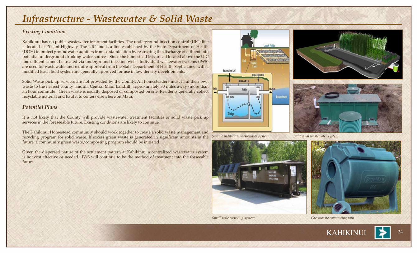
Infrastructure - Wastewater & Solid WasteExisting Conditions
Kahikinui has no public wastewater treatment facilities. The underground injection control (UIC) line is located at Piÿilani Highway. The UIC line is a line established by the State Department of Health (DOH) to protect groundwater aquifers from contamination by restricting the discharge of effluent into potential underground drinking water sources. Since the homestead lots are all located above the UIC line effluent cannot be treated via underground injection wells. Individual wastewater systems (IWS) are used for wastewater and require approval from the State Department of Health. Septic tanks with a modified leach field system are generally approved for use in low density developments.
Solid Waste pick up services are not provided by the County. All homesteaders must haul their own waste to the nearest county landfill, Central Maui Landfill, approximately 30 miles away (more than an hour commute). Green waste is usually disposed or composted on site. Residents generally collect recyclable material and haul it to centers elsewhere on Maui.
Potential Plans
It is not likely that the County will provide wastewater treatment facilities or solid waste pick up services in the foreseeable future. Existing conditions are likely to continue.
The Kahikinui Homestead community should work together to create a solid waste management and recycling program for solid waste. If excess green waste is generated in significant amounts in the future, a community green waste/composting program should be initiated.
Given the dispersed nature of the settlement pattern at Kahikinui, a centralized wastewater system is not cost effective or needed. IWS will continue to be the method of treatment into the forseeable future.
Sample individual wastewater system
Small scale recycling system Greenwaste composting unit
Individual wastewater system

�� KAHIKINUI
Access to Kahikinui is from Route 31, Piÿilani Highway, a Maui County owned 20 foot wide two lane paved arterial that links Kahikinui with the Upcountry communities of ÿUlupalakua, Kula and Makawao to the North, and with Häna to the east. From Piÿilani Highway, a single-lane partially improved four-wheel drive road serves as the main access to the residential Homestead of Kahikinui.
Existing Conditions
As a remote and sparsely populated region, Kahikinui is not generally well served by infrastructure or public services. Additionally, as a pilot homesteading project with the intention of living a sustainable lifestyle off the public service support grid the homesteaders who have successfully built their homes on their assigned lots have independently developed and maintained the bulk of the infrastructure needed to live off the land.
TransitMaui County Department of Transportation maintains a public bus transit system that serves the Upcountry communities of Pukalani Terrace, Häliÿimaile and Makawao. Due to the remoteness of the area, bus service does not extend into Kula and Kahikinui. The Department of Education provides bus service to remote locations if there are a minimum of 7 students in an area. As the number of permanent residents in Kahikinui does not generate 7 students, no school bus service is available and families arrange their own means, often carpooling with their neighbors to reduce fuel costs and time.
RoadwaysThe only standard roadway serving Kahikinui is Piÿilani Highway. The roadway is well paved until Manawainui Gulch. Then it becomes intermittently paved and unpaved till Kaupö. From Kaupö it is unimproved until Kïpahulu. When bad road conditions become apparent, alternate routes and roadways are created that often cut through vacant homestead lots.
Maui County’s proposed 6-year CIP budget for 2010 does not include any road improvements that would benefit the residents of Kahikinui. The State Department of Transportation’s Highways Modernization Plan map for Maui County, as well as their project list, does not include any projects on Piÿilani Highway that will benefit the Kahikinui region.
The homestead area is served by a series of unpaved roadways with a main spine road (Road A) that is paved with asphalt in segments and concrete in two narrow two-foot strips in steeper areas. In between segments are dirt and gravel or compacted gravel. A loop road (Road B) and side spur roads (Roads G and H) serve the remaining lots. All of the roads are unimproved 4-wheel drive roads. Over the years these roads have eroded away and been realigned in some places as residents have tried to repair and maintain the roads; sometimes on their own and sometimes as a group.
There are old ranch, forestry, and hunting related roadways throughout the region. These roads require 4 wheeled drives, off road and extremely rugged vehicles to access. Many of the resource areas such as Kahua cabin and the makai ocean resource zone are inaccessible without such vehicles.
Proposed Improvements
There are no official DHHL plans to improve specific roadways in Kahikinui at the current time. However, there is a designated fund of about $100,000 that can be used for roadway improvements. Discussions continue with DHHL and the homesteaders about how to use the money and potential solutions to the problems associated with the poor roadways. Other sources of potential funding are currently being pursued.
Infrastructure - Transportation: Transit, Roads, & Access
Piÿilani Highway

KAHIKINUI ��
Infrastructure - Transportation: Transit, Roads, & Access
Lot Number
Archaeological Site Boundary and Buffer Zone
Archaeological Site Number
Preserve Archaeological Site & Buffer Zone
Road A
Secondary Spur Roads G-H
Potential South Fire Break Road
UlupalakuaRanch Parcel

�� KAHIKINUI
Infrastructure - Public FacilitiesMedical Facilities
Emergency Medical Technician/Ambulance services for the Kula region are based out of the Kula Hospital located in Këökeo 12 miles from Kahikinui. Most emergencies must be handled by beneficiaries on-site. Most emergency vehicles would be unable to reach individual house lots in Kahikinui as the main road is only accessible by four-wheel drive vehicles.
Kula Hospital is a Critical Access Hospital with acute care beds, skilled nursing/intermediate care beds, ICF/MR developmentally disabled inpatient services beds, a 24 hour emergency room and outpatient clinic with lab and x-ray services.
Maui Memorial Medical Center, which is located in Wailuku and is the County of Maui’s only critical care facility and the Kula Hospital in Këökea together provide acute and general health care services for Kahikinui.
Police Protection
Police protection is provided by the Maui County police station located in Wailuku. The Wailuku Station is the central office for the Maui Police Department and includes eleven (11) beats with 111 patrol officers and 38 investigative officers. A total of 43 officers are dedicated to the Makawao-Pukalani-Kula Community Plan region. There are two (2) beats which patrol the Makawao-Pukalani-Kula region. A police substation is located in the Pukalani Terrace Shopping Center. Police protection is poor and too far away. In addition, they don’t have access to the homestead gate and there are jurisdiction issues related to enforcement on DHHL lands.
Schools
Kahikinui is part of the Kekaulike High School complex. Three elementary schools, one middle school and one high school make up this DOE complex. Additionally, this service area contains seven private schools detailed in the table on this page.
Fire
The nearest fire station is the Kula Fire Station, located aproximatley 25 miles from Kahikinui. It serves the entire upper and lower Kula areas as well as the slopes of Leeward Haleakala from Kanaio to Kaupö. The large size of the region and poor roadway conditions make effecient coverage difficult. Additionally, emergency vehicles cannot climb the homestead roads.
GRADEACTUAL
ENROLLMENT 2007/2008
CAPACITY2008-2009
PROJECTED ENROLLMENT
2012
MILES FROM KAHIKINUI
TRACT
PUBLIC
Kula Elementary K-5 407 637 496 18
Pukalani Elementary K-5 484 561 486 22
Makawao Elementary K-5 491 629 494 24
Kalama Intermediate 6-8 847 1,173 838 24
King Kekaulike High 9-12 1,331 1,254 1,370 24
Total 3,560 4,254 3,684
PRIVATE
Clearview Christian Girl’s School 6-8 18 18
Haleakalä Waldorf Pre K-8 243 18
Kamehameha Schools- Maui Pre K-12 1,084 22
Montessori School of Maui K-5 205 24
Seabury Hall 6-12 415 24
Carden Academy- Upcountry K-5 135 24
St. Joseph School PreK-6
TOTAL 5,228
KAHIKINUI ��
Infrastructure - Public Facilities
n
nn
n
n
n
×
®v
Nuÿu Bay
Huakini Bay
NAKAOHUPOINT
APOLEPOINT
WaiüBay
HaleakaläObservatory
!
Kïhei
Kula
KulaHospital
KulaFire Station
Kula Park
Kïhei Elementary
Kamalii Elementary
Lokelani Intermediate
Nakula NaturalArea Reserve
Kahua Cabin
Hale Pili
Rice Memorial Park
Sun Yat Sen Park
Ahihi-KinauNatural Area Reserve
Hawaii NaturalArea Reserve
HaleakaläNational Park
PIÿILANI
Kula Elementary
KoolauForest Reserve
HanaForestReserve
Kula Forest Reserve
KahikinuiForest Reserve
WaikamoiPreserve
(NATURE CONSERVANCY)
KipahuluForest Reserve
Kanaio NaturalArea Reserve
KahikinuiForest Reserve
Makena State ParkPolipoli Spring
State Recreation Area
UV378
UV37
UV360UV377
UV378
DHHL Kahikinui
Parks/Reserves
NaAlaHele Trails
Public Facilities
®v Clinic/Hospital
× Fire Station
Public Schools
n Elementary
n Int/Middle
n HighN
n
nn
n
n
n
×
®v
Nuÿu Bay
Huakini Bay
NAKAOHUPOINT
APOLEPOINT
WaiüBay
HaleakaläObservatory
!
Kïhei
Kula
KulaHospital
KulaFire Station
Kula Park
Kïhei Elementary
Kamalii Elementary
Lokelani Intermediate
Nakula NaturalArea Reserve
Kahua Cabin
Hale Pili
Rice Memorial Park
Sun Yat Sen Park
Ahihi-KinauNatural Area Reserve
Hawaii NaturalArea Reserve
HaleakaläNational Park
PIÿILANI
Kula Elementary
KoolauForest Reserve
HanaForestReserve
Kula Forest Reserve
KahikinuiForest Reserve
WaikamoiPreserve
(NATURE CONSERVANCY)
KipahuluForest Reserve
Kanaio NaturalArea Reserve
KahikinuiForest Reserve
Makena State ParkPolipoli Spring
State Recreation Area
UV378
UV37
UV360UV377
UV378
DHHL Kahikinui
Parks/Reserves
NaAlaHele Trails
Public Facilities
®v Clinic/Hospital
× Fire Station
Public Schools
n Elementary
n Int/Middle
n HighN
Community Center
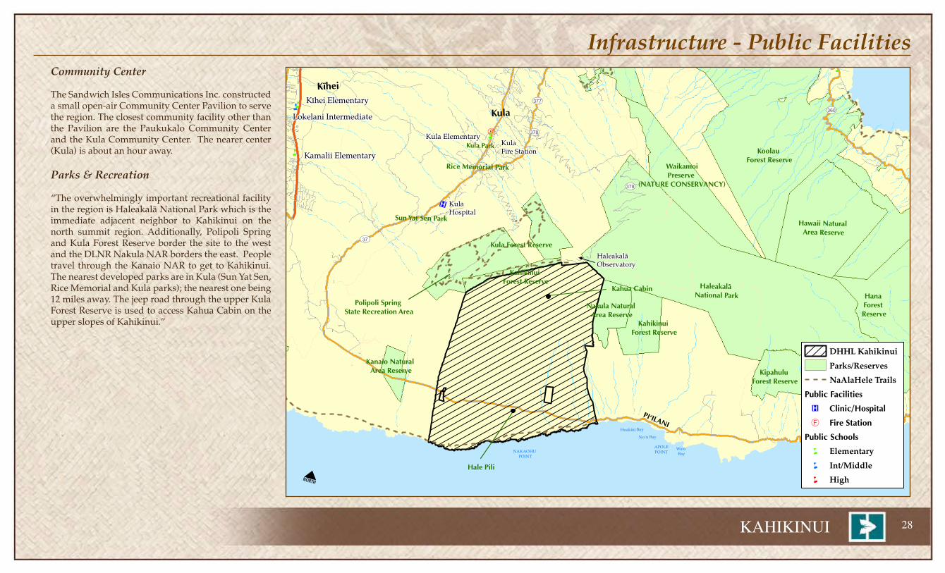
The Sandwich Isles Communications Inc. constructed a small open-air Community Center Pavilion to serve the region. The closest community facility other than the Pavilion are the Paukukalo Community Center and the Kula Community Center. The nearer center (Kula) is about an hour away.
Parks & Recreation
“The overwhelmingly important recreational facility in the region is Haleakalä National Park which is the immediate adjacent neighbor to Kahikinui on the north summit region. Additionally, Polipoli Spring and Kula Forest Reserve border the site to the west and the DLNR Nakula NAR borders the east. People travel through the Kanaio NAR to get to Kahikinui. The nearest developed parks are in Kula (Sun Yat Sen, Rice Memorial and Kula parks); the nearest one being 12 miles away. The jeep road through the upper Kula Forest Reserve is used to access Kahua Cabin on the upper slopes of Kahikinui.”

�� KAHIKINUI
Infrastructure - EnergyThe purpose of the DHHL Hoÿomaluö ENERGY POLICY is to “Enable Native Hawaiians and the broader community working together to lead Hawaiÿi’s effort to achieve energy self-sufficiency and sustainability.”
Existing conditions
Kahikinui is not served by a public electrical utility. The Maui Electric Company’s power grid does not reach Kahikinui. The Kahikinui project exists off the power grid and homesteaders who have built on their lots all have their own source of power. The predominant forms of alternative power generation are photovoltaic, solar thermal heating and wind. Most homesteaders also have back-up generators to serve their emergency needs. Storage of energy from alternative sources is an issue that needs further discussion and development.
CNHA has a program to help homesteaders add solar thermal units for hot water heating. This program can be used to facilitate the addition of hot water equipment to individual homes. Electricity is needed to operate such systems.
There is no telephone service in Kahikinui. Cell phone service is provided by Sandwich Isles Communications Inc.
Projected Plans
The 22 MW Auwahi Wind Power project on ÿUlupalakua Ranch lands is expected to be a major power provider in the region. Its value may be enhanced with the possibility of a pumped hydropower system being considered as a storage system for the project.
This project also provides an opportunity to possibly extend the power grid to Kahikinui. If the project is developed the cost of transmission lines to extend the service into Kahikinui should be evaluated. Homesteaders have begun discussions with Auwahi Power LLC. to discuss potential benefits.
Assessments of wind and solar potential indicate that Kahikinui has good potential for the use of both of these resources for individual homes or even to generate excess power for sale to the power grid. These potentials should be explored in the future and pursued if negative impacts can be addressed and/or mitigated.
The southwest rift zone of Haleakalä has been identified as a potentially promising area for geothermal development. Its proximity to Kahikinui make this potential another possible opportunity for homesteader jobs and benefits.
Small scale home bio-fuels use and production may also be a possibility with agricultural waste and natural resource green waste from forest stewardship as potential fuel sources.
HO‘OMALUŌENERGY POLICY
To enable native Hawaiians and the broader community working together to lead Hawai’i’s effort to achieve energy
self-sufficiency and sustainability.
Mālama ‘āina: Respect and protect our native home lands.
Kōkua nō i nā kahu: Provide energy efficiency, self-sufficiency, and sustainability opportunities to existing homesteaders and their communities.
Ko‘o: Facilitate the use of diverse renewable energy resources.
Kūkulu pono: Design and build homes and communities that are energy efficient, self-sufficient and sustainable.
Ho‘ona‘auao: Prepare and equip beneficiaries to promote a green, energy efficient lifestyle in and around communities.
OBJECTIVE
1
OBJECTIVE
4
OBJECTIVE
2
OBJECTIVE
3OBJECTIVE
5
Develop a comprehensive strategic plan for the protection, restoration and preservation of DHHL’s forest lands. (An appropriate plan that incorporates the preservation of values, traditions, and culture of Native Hawaiians that restores balance, harmony, and sustainability of the forest lands for future generations.)
Develop a comprehensive strategic plan for the protection, restoration and preservation of DHHL’s other lands—lands other than forest lands, lands for homesteading and lands for general lease.
Identify properties in DHHL land inventory that have potential for carbon sequestration and determine if carbon sequestration is a viable use of DHHL lands.
Evaluate each Regional Plan to determine if energy self-sufficiency and sustainability goals and objectives should be incorporated into the regions. (The regions contained within the Regional Plans can serve as today’s “ahupua‘a” - the past Hawaiian land-management system of self-sufficiency for future generations.)
Develop, implement, and maintain plans to reduce DHHL’s carbon footprint (reduce greenhouse gas emission).
Identify properties in DHHL’s land inventory that have potential for renewable energy projects.
Pursue the leasing of those lands that are identified as suitable for renewable energy projects. (First priority should be given to entities that would provide “firm” renewable energy power such as garbage-to-energy (mass-burn), geothermal, pump-storage hydropower, solar-thermal and second priority to “as-available” renewable energy power such as wind, solar-photovoltaic, and wave.)
Encourage existing and future general lessees and licensees of DHHL’s properties to design and build their facilities so that they are energy and resource efficient.
Seek partnerships for the development of renewable energy resources. In this connection, build relationships that could assist DHHL on non-energy related issues.
Evaluate DHHL’s available authorities/powers that could expedite renewable energy projects for the state of Hawai‘i.
Seek innovative processes to provide reliable electricity, by assisting electric utilities (in a world where energy is an essential but very limited resource) to reduce Hawaii’s dependency on fossil fuels.
ACTIVITIES:
ACTIVITIES:ACTIVITIES:
ACTIVITIES:
ACTIVITIES:
Promote, design, and build new affordable homes (that minimize lifestyle and visual impacts) using the “Hawai‘i BuiltGreen” and “ENERGY STAR” programs. (These programs ensure the designing and building of new energy and resource efficient homes in Hawai‘i.)
Strive to plan, design, and build new communities utilizing the “ahupua‘a” concept and the “Green Communities” program. (The Green Communities program’s criteria are designed to provide a cost effective approach and standard for creating healthy, affordable, and environmentally responsible homes and communities.
Assist beneficiaries to utilize energy efficiency rebates, financial assistance, tax credits and other incentives offered by utility companies and federal, state and county governments.
Promote the benefits of hybrid electric vehicles to help reduce beneficiaries’ transportation (gasoline) costs. (70% of Hawai‘i’s imported fossil fuel is used for transportation that must be use efficiently or conserved.)
Assist beneficiaries to obtain mortgages under the “Energy Efficient Mortgage” program. (The program can help beneficiaries save money and, reduce their loan qualifying income requirements.)
Seek partnerships with federal agencies like with the U.S. Department of Energy that provide access to current state-of-the-art technical advancements in energy.
Seek partnerships that provide grants and other financial assistance for the developments of state-of the-art net zero energy homes.
Join with electric utilities and the Public Benefits Administration as partners to advocate, communicate and educate the public on state-of-the-art energy initiatives.
Identify effective energy efficiency and conservation retrofit applications and develop a plan to assist homesteaders with the retrofitting of their homes. (Retrofit applications may include: solar hot water heating system, insulation/radiant barriers, low-flow toilet and shower head, photovoltaic system, CFL bulbs, ENERGY STAR appliances, energy efficient windows, clothes line, ventilation techniques, and roof/attic vents.
Assist homestead communities to achieve potential energy self-sufficiency by identifying properties near existing homesteads that could be utilized for community renewable energy projects that could also generate revenue for their respective regional plan projects.
Seek partnerships to assist homesteaders with retrofit applications and energy self-sufficiency projects.
Help homesteaders lower their monthly electricity and maintenance costs that would increase their purchasing/savings power and generate revenue for their respective Regional Plan projects.
Energy efficient homes generate lower electricity and home mainte-nance costs that would help beneficiaries qualify for a higher home mortgage or increase their purchasing/savings power.
Seek partnerships that provide opportunities to learn how to live a self-sufficient and sustainable, greener lifestyle.
Develop and implement resource efficiency programs for beneficiaries to reduce, reuse, and recycle resources. These resources include construction and demolition materials, household items, yard waste, and other items which might be sent to landfills or incineration.
Assist homestead communities to become more aware of their energy use and carbon footprint.
January 2009
Sandwich Isles Communication Center

KAHIKINUI �0
Infrastructure - Energy
PIÿILANINuÿu Bay
Huakini Bay
NAKAOHUPOINT
APOLEPOINT
WaiüBay
HaleakaläObservatory
!
Kihei
Kula
Pukalani
KiheiKihei
UV378
UV31
UV377
UV360
UV37
UV30
UV350
UV400
UV378
UV37
Haleakala Natl ParkHaleakala Natl Park
DHHL Kahikinui
Solar Radiation
(cal/sq.cm/day)
0
1-250
251-300
301-350
351-400
401-430
431-450
451-500
500-550
551-600
PIÿILANINuÿu Bay
Huakini Bay
NAKAOHUPOINT
APOLEPOINT
WaiüBay
HaleakaläObservatory
!
Kihei
Kula
Pukalani
KiheiKihei
UV378
UV31
UV377
UV360
UV37
UV30
UV350
UV400
UV378
UV37
Haleakala Natl ParkHaleakala Natl Park
DHHL Kahikinui
Wind Power Density at 50m
NREL Class - W/m2
1- < 100
1+ 100 - 200
2 200 - 300
3 300 - 400
4 400 - 500
5 500 - 600
6 600 - 800
7 > 800
Wind Power Density Map
Solar Radiation Map
Geothermal Site Map
Wind power is calculated at 50 meters above ground elevation based on models using 200 meter grid models. The greater the wind speed, the higher the average wind density pressure generated and the greater the potential energy extraction. A figure of “>800” is equivalent to an average wind speed of greater than 19.7 mph. Auwahi seems to be a low wind region but tests indicate local terrain features increase speeds in this area well beyond the computer modeling.
Solar power numbers are based on the average insolation over the year with higher numbers indicating more days of clear skies. The numbers on this map represent average calories per square centimeter per day.
The southwest rift zone of Haleakalä has been identified as one of the promising areas in the State of Hawaiÿi for the development of geothermal energy. Its development may be a source of energy and jobs for Kahikinui.

�� KAHIKINUI
Infrastructure - Community Wildfire Protection PlanThe Kahikinui Community Wildfire Protection Plan was developed by the Department of Hawaiian Home Lands in 2008 and a mutual agreement letter was signed by the State Forester, Division of Forestry and Wildlife, Fire Chief, Maui County Fire Department, Administrator, Maui County Civil Defense and Administrator, Land Management Division, Department of Hawaiian Home Lands.
The executive summary of the plan states, “Kahikinui is in a wildland urban interface (WUI) environment – that is where wild lands and houses meet. These areas pose the highest risk of loss of life and property due to wildland fire. The risk of wildland fire impacting homes in the WUI is determined by several factors, including the ignitability of fuels, structural ignitability, weather conditions, and topographic features, such as slope.”
Unlike other parts of the United States, wildfire is not a natural part of Hawaii’s ecosystem. In Hawaii, wildfires destroy native plants, which can impact the watershed and the habitat of threatened and endangered native Hawaiian animals. Wildfires in Hawaiÿi can also cause soil erosion, which has the potential to cause runoff that negatively impacts ocean reefs.
The overwhelming majority of wildfires in the State of Hawaiÿi, and Kahikinui in particular, are caused by arson or human error. Human error includes errant fireworks, rubbish, cooking, or agricultural fires that get out of control in the wildland-urban interface, as well as vehicle-caused wildfires.”
The plan recommends the following 12 actions:
Improvement of, i.e. paving, main entrance road in residential village. Improvement of Jeep access trail as a secondary means of emergency egress.Creation and maintenance of a buffer zone/fuel break around entire 1,340-acre residential settlement.
Creation and maintenance of a fuel break along fence line being installed by Art Medeiros of the Leeward Haleakalä Watershed Restoration Partnership.
3. Increase utilization of current reservoirs and/or installation of dip tanks. These water re-sources could be fed by seasonal rains from nearby gulches and/or runoff from the Commu-nications Center. (The Punawai project may be a potential water source in case of emergency.)
Developing wells or damming narrow gulches to increase water reservoir resources4. Creation of dedicated landing zones for helicopters for fire suppression proposes.
Creation of a contingency fund to hire private government certified helicopters during wildfires.
1.
2.
a.
a.
a.
5. To save dryland forest during wildfires, KOOK members are encouraged to meet with Maui County Fire Department officials for pre-incident planning meetings to make fire officials aware of sensitive ecological areas.
6. Work with Maui County Department of Public Works (DPW) to ensure Piÿilani Highway roadsides are mowed, particularly in the dry summer months (Maui County Fire Department Chief said he would contact DPW and make this request). When KOOK members conduct community workdays clearing roadside brush, it would be cleared a minimum of 10-20 feet.
7. Reduction of fuel load around individual properties. Increase awareness among homestead-ers of the need to create defensible space with Firewise tips in community newsletter. Hold a fire prevention awareness event at least once a year.
8. Install metal reflective signs showing evacuation routes within the residential village.9. Increase awareness among hunters of risk of wildfires from guns and/or campfires through
informational sessions and outreach with KGLMO members.10. Develop a Community Emergency Operation Plan. This would include identifying points of
contact for ham radio operators, as well as learning how to use ham radios and purchase of the equipment (KOOK members may wish to contact the Ocean View Disaster Preparedness Committee in Hawaiian Ocean View Estates (HOVE) on the Island of Hawaii‘ who instituted a similar plan utilizing block captains and ham radio operators for their community).
11. Community Emergency Response Training (CERT) is recommended for KOOK members.Creation of a contingency fund to hire private government certified helicopters during wildfires.
12. KOOK may want to look into the feasibility of using grant funding to rent a chipper or tractor mower during periodic community workdays.
a.
Haleakalä brush fire

KAHIKINUI ��
Infrastructure - Community Wildfire Protection Plan
Fire assets/access and protection areas
Community Buffer Area
There is a strong desire to move this project listed as item 2 in the summary to a higher priority. Due to its importance to protecting lives and property, many members indicated a sense of urgency in implementing this recommendation.
Hopes are for a buffer around the edge of the entire community along with improvements to some of the roadway systems to facilitate acces for fire protection purposes.
Portions of this buffer area should be fenced to function as enclosures for a nascent ranching program that would be augmented with young feral cattle and animals captured from the various forest restoration programs. It is the desire of the community to use grazing animals to maintain the fire break buffer. The enclosed areas will serve essentially three functions: 1) a clean firebreak, 2) a holding area for feral ungulates relocated from the forest restoration and conservation programs, and 3) the beginning of a community ranching business.

�� KAHIKINUI
V. Homestead Issues & Priorities
Roads• The repair and maintenance of the spine road is the highest priority. The condition of the road
affects the daily lives of all who live in Kahikinui. Health and safety is involved as police, fire, and medical emergency vehicles are either unable to reach the scene or take an inordinately long time to come up to the site of the emergency. Much discussion took place about the quality of the road that was promised by DHHL when the lots were awarded.
• Secondary roads are also important but the priority that should be given to them is uncertain. The creation of a new secondary road at a lower elevation below the loop road would allow access to the lower lots and provide a firebreak and access to emergency vehicles; especially fire fighters. The loop road would help access the pristine upland forests areas.
Community• A larger buffer area is needed around the homestead area. Stray bullets from hunters come too near
to the core homestead area. This is a safety issue.
• The Community Center area improvements should be completed. These include enclosure of the present pavilion and attachment of the water tanks to the roof water catchment pipes that are already there. These will provide a good facility for social and community events.
• The need to bring more young people into the planning and settlement efforts of Kahikinui was mentioned several times. The vision for the project must draw more young people.
• The number of people living in the homestead should be increased. There is a need to create a critical mass of people at Kahikinui to create a stronger community and give it a greater voice with DHHL and the broader community.
• The community parcels should be developed. A school, general store and water system for the whole community would be good to have.
Resource Managemnt• The partnership with Art Medeiros on the forest restoration plan is very exciting. The community
would also like to work with him in the feral cattle eradication program to possibly domesticate some of the animals. A partnership to improve the service road to the preserve area also seems possible and would have a mutually beneficial result.
• The LIFE ecosystem preservation fencing program remains a high priority for the community. Walter Kanamu agreed that some earlier fencing material bought for the project that turned out to be too short can be used for other purposes by the community. LIFE was supposed to be under KOOK, not a separate organization.
• The makai area is being managed as a resource zone following ahupuaÿa concepts. It should be reserved for the moÿopuna to determine its long term future use and development.
• Feral cattle are dangerous and destructive. They often destroy fences, eat plants and damage other structures. They should be eradicated from the homestead area. If they are coming from ÿUlupalakua, the Ranch should put up the 2 miles of fence to keep them out of DHHL lands.
• Partnership agreement with KGLMO and LIFE have not been successful.
• Fire is a big concern. Implementation of the fire plan is important and a high priority as uncontrolled fires put the whole community at risk. There is a fire plan but funding is needed to implement it.
• Individual homesteaders need to fence in their own animals.
• Feral animals often damage fences and property.
Water• The development of the cloud capture system for the community should still be a priority. Lessons
have been learned from the earlier efforts with Dr. Juvik and the system should be built. Water is important for potable purposes, agricultural use and fire protection. The cloud/fog capture system can be used for multiple community purposes.
Over the course of the development of the regional plan many ideas, issues, concerns and priorities were raised. Some evolved into priority projects for the plan. Others will be reserved for future discussion or consideration. The following summarizes major ideas and comments that were raised:

KAHIKINUI ��
Community Based Economic Development• Need start up capital to rent equipment and purchase supplies to get started.
• Need to create jobs in and around Kahikinui.
• Kahikinui has lots of rocks. The rocks should be viewed as resources and partnerships should be developed with local construction companies to trade resources and help with road improvement and maintenance. A quarry operation is possible and might be an income generator.
• Commercial uses should be developed along the highway especially at Hale Pili.
• Some of the remote, large, dry, vacant lands like Kahikinui which were viewed as rubbish lands are now being viewed as valuable for projects like renewable energy development. The community supports development of renewable energy projects but benefits must accrue to the community. The community should be involved in negotiations with project proponents from an early stage of the negotiations.
• Reforestation with an ultimate tropical hardwood silviculture plan in mind is still a long term goal of the community. The community understands it is a 30 plus year project which will be multi-generational in nature.
• Homesteaders need help in purchasing and installing sustainable equipment and products such as heaters, windmills, and photovoltaic panels.
Governance/Enforcement• Some lessees have been problematic for the community as a whole. A policy and mechanism to
terminate some leases and possibly evict some tenants should be developed. This will increase the safety and cohesion of the homestead community
• DHHL should enforce rules and prosecute trespassers. Some unsavory people come through the land and rustle cattle and give the homestead a bad reputation. Security and prevention of theft needs to be improved.
• Violence among residents and from infiltrating outsiders is intolerable. The community needs to come together to eliminate this problem by evicting the people who are perpetrating this kind of behavior.
• Hard drugs have no place within Kahikinui. Ice clouds judgement and often results in bad decisions and actions. There should be no tolerance for hard drugs and people who use them will be reported.
• Some have complained that the Board of Directors are not adhering to the adopted by-laws.
• A designated/hired security enforcement officers is needed for Kahikinui.
• Greater/better communication with DHHL is needed.
• The KOOK governance structure should be re-evaluated and the relationship to KGLMO and LIFE should be reviewed and revised if necessary.
• Clearer definition of zones and enforcement areas are needed. Maps and text should be adopted.
• Illegal night hunting is often linked with vandalism; breaking locks and cutting fences. This needs to be stopped.

�� KAHIKINUI
Priority Project: Homestead Development Facilitation ProgramDescription
This priority project is focused on helping lessees build and settle in Kahikinui by creating a Homestead Development Facilitation Program. The two major components of this project include a site for a facility and a “How To” reference manual to help homesteaders with information and instructions on how to create a homestead. One of the difficulties of development at Kahikinui is the lack of a place to temporarily store construction material and a place to stay while the individual homes are being worked upon. Hale Pili is intended for this use but there are some difficulty with this function as site security and capacity are limited. Also, Hale Pili seems to have greater long-term potential as a historic site and community commercial node. When there values increase and expand, it will conflict with its use as a logistical center for development. The creation of a temporary storage and staging facility closer to the main Highway to assist homesteaders with logistics in construction and site development is recommended. The site should be fenced with a locked entry. A secure site close to Piÿilani Highway where larger volumes of material can be easily and safely stored would greatly aid homesteaders in constructing their homes. Security is a big issue as people have cited examples of theft and vandalism regarding supplies and equipment left on individual lots. Also bringing larger volumes of construction material up to individual lots is difficult to do in one load or even several small loads. A site near the highway would allow homesteaders to order larger loads of material that can be delivered by commercial suppliers and left within this compound since such vehicles would generally not be able to go up the homestead roads directly to the individual lots.
This site should also have a place of modest accommodations to house a few people near the supply area. There should be water and restroom facilities at the site for the people working on their homes.
A “How To” manual on homesteading should be developed. Among other information, this should clearly include the direct experience of the homesteaders who have built houses on their lots. As Kahikinui is an experiment in progress on how to homestead and steward large tracts of undeveloped land, this manual will guide new residents in ways to minimize mistakes and optimize opportunities that exist. It should also be a summary of lessons learned from 15 years of settlement experience.
Phasing and Cost
Cost estimate: Phase one planning and programming should range between $15-$30,000. Phase 2 cost depends on strategy option: e.g. modular pre-built structure or design/build. Prebuilt is probably more practical and cost will vary with model and size.
Potential Partners
DHHL is the obvious partner for the homestead community. If it can be done with some modest initial support, in the long run it will help place more beneficiaries on the land. Other potential partners may be building supply companies and/or general contractors who may also benefit from such a facility with greater potential sales and work. Other potential partners are non-profit foundations who value the ideals represented by the effort at Kahikinui. This site could be roadside complex that could later be converted to commercial or other income generation activities that compliment the Hale Pili site This is the gateway to the community and should be planned carefully.
Next Steps
Organize a DHHL group with community assistance to determine programmatic needs, e.g. space program, design, logistics and strategy, gain community consensus and specify a location.Develop a site plan, develop construction cost estimates and request a license from DHHL to use the site for this purpose. Cost will depend on the size of the site and buildingsDevelop rules for facility security, maintenance and use. Have a business plan for operational maintenance costs for upkeep, repairs, water, power, wastewater etc.Obtain construction funding.Finalize construction plans and bid for a general contractor.Identify Homestead people to write the “How To” manual.Obtain grant money to produce the manual.
•
•
•
••••
Timeline
2011 2012 2013 • Year one, organize group, assess
needs and develop plan.• Form manual committees.
• Year two, obtain funding and obtain development permits.
• Publish manual.
• Year three, start and finish construction.
Example of accommodations during construction Example of building supply storage

KAHIKINUI ��
Priority Project: Homestead Roads - Improve & Develop Roadway NetworkDescription
Improved access to the homestead lots is a critical need for Kahikinui. Over the years there has been much discussion and disagreement about the commitment and quality of roadway access to the lots that have been awarded. One thing remains clear, the roads of Kahikinui are extremely rough and maintenance has been a problem since the beginning of the homesteading awards in the late 1990s. The difficulty of access remains the primary impediment to the pace of homesteading and difficulty of daily life in the ongoing settlement of Kahikinui. There is broad consensus that the improvement of the roadway network is the primary project for the residents of the region. Improving Road A will help speed up the settlement of lease awardees on to the land. See map on opposite page.
Easing the daily burden of travel to and from the homestead lots is the ultimate goal of these improvements. The length commute time and the physical toll on automobiles/tires creates an excessive burden on homesteaders. Experiences within the last 15 years have also shown the importance of improved roadways in other dramatic ways. They are critical for providing emergency vehicle access, such as, police vehicles, fire trucks, and ambulances to reach the majority of the homestead lots. Right now, these vehicles either cannot access the site, or, when able to, take hours to respond. Roadways also create natural fire breaks that slow or cease the progress of out-of-control fires.
Another value is to improve logistics for land stewardship and reforestation of Kahikinui. Part of this includes alien species control and removal of everything from feral animals to gorse.
Along with these improvements, site drainage should be assessed to provide swales and culverts to direct storm water runoff to prevent erosion of the roadway. Runoff should be directed to areas that are not vulnerable to erosion or into retention basins where they may percolate into the ground or provide a source of irrigation or fire-fighting water for homesteaders. These drainage improvements should be part of the roadway network improvements.
Phasing and Cost
Phase IThe Roadway network can be broken up into several segments or phases. First is the main spine road (Road A) from the highway to the Communication Center. This road has been partially paved and paved in sections. The community vision for this improvement is to complete pavement of the steeper sections of the roadway that often become impassible in rainy weather (generally slopes over 12%) with parallel concrete lines about 2-3 feet each. Gentler slopes can be paved with asphalt. This summit of the spine road should be phase one of the system improvement. This project can be achieved by the use of the annually appropriated $100,000 account for roadways that already exists in DHHL’s budget. The improvements can be done incrementally with trusted bulldozer operators who know the land and can provide the service economically. Preliminary estimates obtained from a contractor indicate it can be done for around $120,000. An existing agreement with Miyake Construction or someone similar could supply the concrete at reasonable rates. Our 2009 estimate for roadwork from the entrance at Piilani Highway to the Communication Center came in at $135,000.
Phase IIThe second set of roadways that should be improved is the remainder of Road A and all of Road B. Together, they form the main loop system around for most of the homestead area.
Phase IIIThe third improvement that should be considered is development of an existing road easement that is not named on the subdivision maps. This road easement runs along the lower sections of the middle area of the homestead lots. It is part of an old road network that has been largely abandoned. It can be used to provide access to some of the lower lots that are currently inaccessible and function as a fire break road to protect the homestead area from fires that may start from makai areas where brush fires are more likely to begin.
The remaining roadways should be improved at later phases.
Piÿilani Highway beyond Manawainui

�� KAHIKINUI
Priority Project: Homestead Roads - Improve & Develop Roadway NetworkPotential Partners
Again, the logical main partner is DHHL. Also, DHHL has allocated $100 thousand a year in funding for road repair and this could be used to begin the first phases of the priority project as soon as costs are established, design drawings are completed and construction phases identified. As noted in the previous priority project, contractors and construction material supplies are also logical potential partners in both getting the material economically and in the actual construction of the improvements. Other potential partners include the Leeward Haleakalä Watershed Restoration Partnership, DLNR (reforestation projects), County of Maui Fire Department and Civil Defense (to improve emergency logistics), and Department of the Interior and Department of Agriculture for conservation efforts and rural development.
Next Steps:
The following next steps are suggested:Work with DHHL to access the available funding. Inventory the roadway network to identify critical segments of Road A to the Comm. Center. Develop detailed cost estimates for the improvements and obtain construction cost estimates.Identify the desired approach to construction and develop a business plan. Link Loop road to resource management plans. Find development partners. Finalize a roadway improvement phasing plan that links the new makai road to fire protection. Look for additional funding sources and lobby for additional funding. Obtain partners and additional funding. Be creative in this search and include sources related to fire safety and natural and cultural resource protection. Obtain cost estimates for the remainder of Road A, B and the makai access/firebreak road. Start improvements to secondary phase roadsObtain remaining funding. Implement as funding is obtained. Plan for the remainder of the mauka network. Begin consideration for makai system.
••••••••
••••
Subdivision Road Map
Timeline
2011 2012 2013 • Year one, complete Phase 1 plan and
coordinate with DHHL.• Start main road improvements.
• Year two, complete roadway plan.• Obtain additional funding.
• Year three, begin work on Phase 2 roads.

KAHIKINUI ��
Priority Project: Resource ManagementDescription
Kahikinui is a pilot project in the relationship of people to the land; a pilot project to bring kanaka maoli back to the ÿäina to practice and live lives centered on traditional values. It is an attempt to live a lifestyle on the basis of values such as aloha ÿäina and mälama ÿäina; to live sustainably in harmony with the nature. It is homesteading with a Hawaiian heart. As such, the relationship to nature is key to the meaning and purpose of Kahikinui. Resource management and alien species control are at the heart of the program.
As mentioned previously, Haleakalä and specifically the south flank of Haleakalä is an extinction epicenter of the world. Kahikinui is home to the largest intact mature mesic koa forest on Maui and therefore critical to the preservation of the native ecosystem that is home to many the endemic species that call Maui home. The Maui parrotbill is one of these poster endangered species that live in these forests. The protection and preservation of the Kahikinui forest is critical to the survival of the parrotbill and other native and endangered plants and animals.
Resource Management Fencing is needed to protect the forest. It must be designed to prevent alien species (cattle, goats, deer and sheep) from decimating the native ecosystem. There is an existing project that is partially funded to enclose the heart of the Kahikinui forest. A major component of the plan is the project represented by the agreement between the Leeward Haleakalä partnership and LIFE. This section of forest is located adjacent to another, smaller area owned by the DLNR that has been designated as a NAR site. DLNR is in the process of fencing their NAR area. The Kahikinui site can be fenced with about 3/4ths of the perimeter involved by eliminating the east NAR perimeter fence.
Alien species eradication and control program is needed. This program must address both flora and fauna since, in addition to feral ungulates, gorse has been sighted on the land and miconia also has the potential to spread here and become a problem. Currently KGLMO has the license with DHHL to manage hunting on the vacant mauka Kahikinui lands. This arrangement should be reviewed to see if additional programs or policies are needed to fully implement the plan and ensure its compatibility with other activities.
The gorse eradication program has funding from DHHL. Homesteaders should be included in the eradication program and hired to do the field work as much as practicable. Mike Robinson is the DHHL contact person for this program.
Phasing and Cost
The existing project is a federally funded through a partnership between the Leeward Haleakalä Watershed Restoration Partnership and LIFE. Funding for Phase 1 include the following:
Fencing - ($200,000 Leeward Partnerships) ($500,000 – LIFE) $1.3 million is the estimated cost for the whole enclosure.
Other measures to consider include:Relocation of pipi or cows & other species to the homestead area for ranching and animal husbandry. Only animals that have the potential to be controlled would be gathered for this purpose. Homestead area fencing for corrals and enclosures are needed to implement this plan. This plan should be designed so the pasture/grazing areas can double as fire break areas to protect the homestead.The gap in the ÿUlupalakua Ranch Fence (approximately 2 miles) should be closed to prevent the unregulated movement of cattle from ÿUlupalakua Ranch to the Kahikinui lands. The current situation leads to interbreeding of ranch and feral cattle that causes problems on both lands. This project is currently underway with resources coming from the Ranch and the Wind Project. The gorse problem is currently at a manageable level. This window of opportunity will not last long and the problem should be attacked immediately. While DHHL has a program to eradicate gorse, the effort has been slow in moving forward. The homestead community should be engaged to assist with this program. They are, after all, the maka ÿäina’s literal eyes on the ground.
••
•
•
•
•
Koa tree Grazing cattleSandalwood tree

�� KAHIKINUI
Potential Partners
Natural resource management requires partnerships with neighboring land owners, similar minded individuals, and organizations because the scope and scale of the challenges is so large. In the case of Kahikinui, the first natural partner is the Leeward Haleakalä Watershed Restoration Partnership whose mission is so closely aligned with the Kahikinui Kuleana mission. The Alliance also brings to the effort expertise and resources that KOOK does not have and the partnership is mutually beneficial. LIFE and KGLMO are also natural partners in the mission if projects and organizations can be properly aligned from a structural standpoint. Another natural partner is DLNR, who is conducting a similar fence program as LIFE in the neighboring Nakula NAR. The University of Hawaiÿi and the Solar Telescope Organization are other potential allies as they have conservation requirements for the summit region which abuts the Kahikinui mauka edge. Finally, ÿUlupalakua Ranch and Haleakalä Ranch are also potential partners, controlling the movement of cattle across the grazing lands on both sides of the property line. DHHL remains a natural constant as a lead partner with the homesteaders since this is commission land and resource management and stewardship are also priority goals for DHHL.
Next Steps
Review and revise resource management policies and objectives for KahikinuiCoordinate efforts with LIFE and KOOK to develop community consensus on how to proceed with the project to make sure funding is preserved and the project proceeds. Assist DLNR in completing the environmental assessment to release the funds. Coordinate efforts and design with the DLNR NAR effort to align fencing and possibly assist in the logistics. Organize and engage the homestead community to participate in the project and lobby DLNR to use homesteaders in the work as much as possible. Request /lobby to obtain funds to complete the full project. Begin conversations with the Telescope Development project to close off the summit boundary of the protection area.
Organize a committee to develop a Feral Ungulate/Alien Species Management Plan for Kahikinui.Review and coordinate hunting program with KGLMO and identify programs and activities needed in addition to their work to achieve the broader objective.Develop plan and proposal for pipi relocation and containment fencing around the homestead area.Begin discussions with ÿUlupalakua Ranch to close the two mile gap on their boundaryObtain funding for the remainder of the enclosures or obtain through partnership with ÿUlupalakua Ranch, AWE project, Telescope project, DLNR NARS and others.Assist with Gorse eradication program
•
••
•
••
•
•••
•
Timeline
2011 2012 2013 • Year one, complete entitlements and
partnership agreements.• Year two, start fence construction. • Year three, complete phase one
fencing.
Priority Project: Resource Management
Piÿilani Highway
Grazing
Watershed Conservation Phase I
Watershed Conservation Phase II
Silviculture I
Silviculture II
Homestead Community
Nu'u
Kalulu
'AlenaKipapa Naka'aha
Wai'opai
Nu'u Bay
Waiu Bay
Niniali'i
Wekea Pt.Koa Heiau
Manawainui
Lapehu Pt.Mamalu Bay
Puka'auhuhu
Kanaloa Pt.
Nakaohu Pt.
Huakini Bay
Kiakeana Pt.
Kahawaihapapa
Nu'u Salt Pond
HALEAKALA NATIONAL PARK
KULA FOREST RESERVE
KAHIKINUI FOREST RESERVE
KULA FOREST RESERVE
KANAIO NATURAL AREA RESERVE
KAHIKINUI FOREST RESERVE
WAIKAMOI PRESERVE (NATURE CONSERVANCY)
POLIPOLI SPRING STATE RECREATION AREA
Legend
DHHL Kahikinui
Proposed DHHL Land Use
Grazing
Homestead Community
Silviculture I
Silviculture II
Watershed Conservation Phase I
Watershed Conservation Phase II
LIFE FenceNAR BoundaryReserves/Parks
Kahikinui 2 Small Parcels
N Proposed DHHL land use
Note: Gorse has been found in small pockets on the mid-elevation portions of Kahikinui.

KAHIKINUI �0
Priority Project: Develop a New Stewardship Economy for KahikinuiDescription
There is general support for the concept of developing new economic opportunities for Kahikinui that are in tune with its resources, compatible with the land and Hawaiian cultural values. However, the range of ideas is extremely broad and community preferences seem to focus on shorter term more immediate opportunities. This is appropriate in that for the most part these activities tend to be stand alone and are not connected to each other. The following ideas received interest during the selection of priority projects indicating homesteader interest in following through with them.
Develop the Hale Pili area as a commercial node for the region. Facilities should include a convenience store, restroom facilities and a gift/craft shop. The rest stop is important to entice people to stop along the route from Häna to ÿUlupalakua. Tourists in groups, bikers and bicyclist and others traveling through the district would not have had a rest stop for miles in either direction and would welcome a rest stop in a location with a great view. During the stop the product, history and craft of the region could be sold. The unique qualities of Kahikinui should be presented.Salt collection and sale was selected but this is probably a proxy for a more general sale of local products from the natural resources of the land and sea. These resources must be protected and managed and sustainably harvested. Tropical hardwoods, various jerky from the land and sea could also fall into this category.Develop cabins for community use but allow rental to outsiders for a fee. This concept provides for recreational access to the natural resources of the region including the makai and mauka areas. These cabins could be the beginnings of eco/cultural tours that tread lightly on the land.The AWE project is moving forward. Residents feel the project impacts Kahikinui and there should be some compensation to Kahikinui for these impacts. Negotiations with AWE are underway to obtain community benefits. These include jobs and other issues; possibly energy bill rebates or subsidies. These efforts are generally supported. Also, AWE represents that broad category of renewable energy projects that may develop in the region. The basic sentiment seems to be that renewable energy development is a generally desirable goal and the people of Kahikinui want to be participants in it both philosophically and directly with jobs, project planning and development of benefits packages.The idea of developing a quarry/batch plant in Kahikinui was an idea mentioned from the very early meetings for the regional plan. A site near the Luala’ilua was previously used as a rock quarrying operation and could be resurrected into a business owned and managed by the community. As one member said, Kahikinui has lots of rocks. It might be needed during the construction of the AWE project.
•
•
•
•
•
Potential Partners
The evolution of a new economy is a complex and confusing process. While the broad parameters of a stewardship economy have been articulated, translating this into specific businesses and economic activity will be largely dependent on individual champions of the ideas and potential partners with the resources to implement the idea. Potential contractors and building supply companies have already been mentioned for the quarry. Eco-tours may be enhanced by partnerships with firms already engaged in this kind of business. DLNR, KOOK, LIFE, and KGLMO are also natural partners here as is the Leeward Haleakalä Watershed Restoration Partnership, DHHL, Alu Like, OHA, and Kamehameha Schools. Much will depend on entrepreneurial individuals and approval from DHHL.

�� KAHIKINUI
Priority Project: Develop a New Stewardship Economy for KahikinuiNext Steps
As the projects mentioned in this category are disparate and not integrated, they will require community consensus and individual champions in the community. Some, such as the negotiations with AWE, have already started. Others like the redevelopment of the Hale Pili area into a commercial stop and the quarry idea are only in the talking stage. Some, like the salt harvesting and marketing could be done by individuals while most of the others will take group efforts. Sustainable living and a sustainable economy is envisioned to work in concert and create a pioneering lifestyle that is appropriate for the 21st century, based on sustainable stewardship and resource management. It is something that is being invented as the Kahikinui experiment evolves.
A way to proceed seems to be a community wide charrette focused on values, lifestyle and desired relationships to the ÿäina first and then the economy. Once the philosophical framework and structure is set individual projects can be assessed as to whether they are compatible and enhance this new economy. The seeds of this new economy are implied in the original vision statement for KOOK that was drafted in 1995. It leads with a statement that the Kahikinui Kuleana Homestead Program will be an “intentional community… based on the ahupuaÿa concept of land planning and land management …geared toward a contemporary Hawaiian off-grid lifestyle.” Other statements that follow reinforce the direction.
While the community charrette is proceeding, the individual projects mentioned above should continue though some priority focus and narrowing should take place.
Members should engage in capacity building and entrepreneurial skills training to take advantage of an economy based on resource stewardship. DHHL, Alu Like, OHA, Kamehameha Schools and other organizations have programs in these areas.
Then KOOK should ask DHHL for the flexibility to consider ideas homesteaders may want to pursue within the broad land use designations for Kahikinui within the Maui Island Plan.
Pursue partnerships.
•
•
•
•
•
Timeline
2011 2012 2013 • Year one, continue existing initiatives.• Organize a community planning
charrette for a new economy.• Identify project leaders.
• Year two, designate Kahikinui as a new kind of enterprise zone.
• Develop specific plans for areas in Special Districts
• Year three, focus on Hale Pili site development as a community/commercial node.
Haleakalä Watershed Restoration Partnership volunteers
Kahikinui ahupua‘a map
Model stewardship concept Source: Kamekameha Schools
Hoapili Tra il
Piÿilani Highway
Kahikinui
St. Inez Church
Puu Pane
KULA HWY
Nuÿu
Kanaio
Naholoku*
Nakula*
Kalialinui*
Auwahi
Kamaÿole Waiohuli Koÿolau
Paeahu
Keÿanae
Këökea
ÿAlaenui
Papaanui*
Papaanui*
Kaloÿi
Waiakoa
Kamehamenui
Palauea
Kaÿonoÿulu
Kaÿäpahu
Haÿikü Uka
Pülehunui
Keauhou
Kalihi
Köheo 1-2
Papaka Kai*
ÿAlae One-Two
Mohopilo
ÿAlae Three-Four
Kualapa
Pülehuiki
Papaka Uka*
Kawaipapa
Kepio
Kalepa
Kaapahu
Puu AhuliliUma
Kahua
Alena
Puukao
Nawini
Kipapa
Kalulu
Auwahi
Nakaohu Nakaaha
Kanaloa
Manukani
MahamenuiLualailua
Waiakapuhi
Manawainui
Kahiki nui
Kepio Point
Kamole Gulch
Kailio Point
Wailaulau Gulch
Lualailua Hills
Kahiki nui House
Kahiki nui Forest Reserve
AlenaKipapa
WaiopaiPakowai
Nuu Bay
NakaahaNinialii
Manawainui
Wekea Point
Huakini Bay
Apole Point
Palaha Gulch
Mokuia PointLapehu Point
Kepuni Gulch
Nakaohu Point
Kahawaihapapa
Kiakeana PointMakaakini Point
Manawainui Gulch
Ahupuaÿa
DHHL Kahikinui N

KAHIKINUI ��
Priority Project: Pünäwai Project & Water Infrastructure ImprovementsDescriptionThe availability of water is a constant constraint in Kahikinui. Homesteaders rely on hauling water, almost daily, to store in water catchment systems. Test mist capture structures were developed during the early days of Kahikinui. The system captured water and the technology has been shown to work. One lesson learned was the need to protect the fog screens from feral ungulates. The other is the importance of the designs for collection and retention facilities of the system along with transmission.
Community SystemThe proposed project calls for the development of one or more tanks/reservoirs to retain the water collected by a mist capture system e.g. fog screens. The initial capture area should be a 5-10 acre site fenced for protection from people and animals. Reservoirs should be lined to the top of the bank. Reservoirs also need to be protected from contamination by fencing or other means primarily from feral animals and possible human activity. A house/shed should be built next to the reservoirs to accommodate the presence of a waterman/guard, if needed, to maintain and protect the equipment and the water and to house maintenance equipment for the system. These fog screens and reservoirs should be located above the homestead areas in the Dry Montane Forest zone between 975 to 1,980 meters above sea level. Water tanks should be installed in the lots toward Puÿu Pane. A large reservoir should also be developed below the Comm. Center.
A pipeline system (tentatively estimated at 2 inch diameters) is needed to bring the water from the reservoirs to two 100,000 gallon storage tanks. These tanks should be developed makai of the reservoirs but mauka of most of the homestead lots. From the reservoirs there needs to be a system that follows the main roads down to the lowest users. The lessees will be responsible for bringing the line from the main road to their individual lots and houses.
Individual HomesteadsDHHL should consider setting up a program to subsidize each homestead lot with a 15,000 gallon tank. This is a relatively small site development cost when compared to normal site development subsidies provided by the Department for a normal housing project. While the original concept for Kahikinui did call for off grid independence and general self sufficiency from DHHL support, Kahikinui remains a pilot in progress and one of the lessons learned is the importance of having a water tank of sufficient size to support domestic use. For the majority of the year, water from roof catchment fills the tank and supplies most of the domestic needs of the homesteading family. It provides a good economically reasonable kick start to the individual lot development process. The cost is estimated to run between $10,000 and $20,000 per homestead. Helping the homesteader at this level of subsidy will help put more people on the land more quickly. Appropriate placement of the tank on each lot is important from a water pressure standpoint.
Potential Partners
This is a partnership program between DHHL and Homestead beneficiaries. It would be a way to accelerate the full build out. It is also a novel concept for a water delivery system and it might be possible to obtain support and/or funding from other potential interested parties such as the County Department of Water Supply, DLNR or the U.S. Department of Agriculture. Other more peripheral but possible interested parties may be organizations like the Nature Conservancy or the Natural Resource Conservation Service.
Next Steps
Pünäwai ProjectThe fog capture system should be revisited for efficiency and cost. A concept idea should be evaluated from an engineering perspective. After cost estimates are developed a grant requested or some other form of funding should be sought to conduct final engineering design, permitting and construction. Because of the novel nature of this project, non-traditional funding sources should be investigated along with conventional sources. Bid and select a general contractor for the project.The plan should include funding to pay people for time spent guarding the facilities. A system of rotating security responsibility among homesteaders should be considered. A maintenance plan should be developed which includes an operational funding plan.
Water Tank SubsidyDraft a proposal requesting the Hawaiian Homes Commission to institute a subsidy to provide a 15,000 gallon tank for each lessee who could use one to kick start his/her settlement activity. Submit and lobby for approval
•••
••
•
•
•
Timeline
2011 2012 2013 • Year one, finalize plans for system. • Year two, obtain funding and obtain
entitlements.• Year three, start construction of
Phase 1.
Fog capture system

�� KAHIKINUI
DEPARTMENT OF HAWAIIAN HOME LANDS
Hale Kalanianaÿole91-5420 Kapolei Parkway
Kapolei, Hawaiÿi 96707
Telephone: (808) 620-9500Facsimile: (808) 620-9559
www.hawaii.gov/dhhl
Prepared by:
Contact Information

KAHIKINUI

�� KAHIKINUI