john wesley powell and the mapping of the colorado plateau, 1869
TRANSCRIPT
Annals of the Association of American Geographers
, 92(3), 2002, pp. 548–572© 2002 by Association of American GeographersPublished by Blackwell Publishing, 350 Main Street, Malden, MA 02148, and 108 Cowley Road, Oxford, OX4 1JF, UK.
John Wesley Powell and the Mapping of the Colorado Plateau, 1869–1879: Survey Science, Geographical Solutions, and the Economy of Environmental Values
Scott Kirsch
Department of Geography, University of North Carolina at Chapel Hill
In 1869, John Wesley Powell led an expedition down the Green and Colorado Rivers through the Grand Canyon,the last “great blank space” on the map of the continental U.S. In the work of filling in the continental map, Powelland others in an emerging community of government scientists in Washington anticipated a new set of concernsover productivity, order, and the limits of natural resources—including land itself—in the arid lands of the West.This article examines the historical geographical processes through which Powell’s maps of an unexplored regiongave way, in roughly a decade, to his maps of proper land use, epitomized by his 1878
Report on the Lands of the AridRegion of the United States
, which is still conventionally recognized as a foundational piece in American environ-mental thought. Focusing on the work of the Powell Survey (1869–1879), as well as Powell’s lesser-known work asa special commissioner for the Bureau of Indian Affairs (1873–1874), the article situates the maps, censuses, and ex-pert advice produced during Powell’s early career as part of a wider traffic of knowledge linking Washington to thewestern territories. The article develops a broadly materialist geographical analysis to explore how the productionof knowledge about people and place on the Colorado Plateau articulated with the westward geographical expansionof systems of value and signification. It thus raises questions about the relations between environmental values, onthe one hand, and the scientific and political work of valuing environments, on the other.
Key Words: environmentalvalues, governmentality, history of science, John Wesley Powell, property.
Let us not gird science to our loins as the warrior buckles onhis sword. Let us raise science aloft as the olive branch ofpeace and the emblem of hope.
—John Wesley Powell (1882, 70)
n
Beyond the Hundredth Meridian
([1954] 1992, 47),Wallace Stegner’s widely read biography of JohnWesley Powell, a moment of extraordinary geograph-
ical coincidence occurs when, as Powell and his crew arecamped at Green River Crossing, Wyoming in May 1869,preparing to embark down the Green and Colorado Riv-ers through the Grand Canyon on the last exploration ofan unmapped region in the U.S., “[T]he first transconti-nental train crossed the bridge above them and by itsmere passing drew a line between periods of history.”Placing these events together, Stegner marks what seemsa profound dual movement in the transformation of theAmerican West: the simultaneous “closing” and “open-ing” of space and frontier. Interestingly, however, thiscrossing of paths with the railroad went unremarked inPowell’s own many published accounts of the explora-tion (1875a, 1875b, 1875c, 1875d, [1895] 1961). If ithappened—and there is no reason to doubt it—then the“line drawn between periods of history” was less obvious
I
to Powell than it was to Stegner. But then, throughouthis career as an explorer, scientist, and bureaucrat, it wasthe mapping of geographical spaces and boundaries thatmattered most to Powell, not historical ones. This is notto say that he was unconcerned about the “closing” ofAmerica’s western frontier, but to specify that he saw fill-ing in the empty spaces of the map, and the constructionof boundaries at a number of spatial scales, as practicalsolutions—in science and in government—to the prob-lems raised by this new sense of geographical limits.
Positioning Powell against this backdrop of the traincrossing the western landscape, Stegner had good reasonto admire him. Powell spent much of his career arguingfor land policies that would reflect the special value ofwater (and access to water) in the arid lands, and he didso at least in part to protect the region from capitalist ir-rigation companies and land speculators. In his landmark
Report on the Lands of the Arid Region of the United States
([1878] 1962), Powell proposed a new land-use classifica-tion scheme for the arid parts of the country based on ob-served physiographic characteristics. He went so far withthis proposal as to include plans for communitarian irri-gation districts that would manage the water on a localbasis. Long after Stegner (1957, xiv; cf. 1962, 1980, [1954]
John Wesley Powell and the Mapping of the Colorado Plateau, 1869–1879 549
1992) solidified Powell’s place as a hero of conservationthought and an advocate of government science “in thepublic interest,” Powell’s
Report
is still widely known, asBenton and Short (2000, 58) put it in a recent anthol-ogy, as “the first serious attempt to introduce an environ-mental sensitivity to federal policy.” Yet much less hasbeen said about the specific contexts and practices throughwhich Powell came to know these environments, or aboutthe purposes that this knowledge was intended to serve.
This article examines the work of survey science, car-tography, and expert advice as governmental mediationsbetween Washington and the western territories duringPowell’s early career. The period between 1869 and 1879is of special importance here because it is bracketed onone side by Powell’s first Grand Canyon expedition(which helped to earn him a permanent place in thewestern surveys and in Washington’s scientific establish-ment) and on the other by the second printing of his
Report
and the subsequent consolidation of the four west-ern surveys into the U.S. Geological Survey (USGS).
1
Focusing empirically on what came to be called the “Geo-graphical and Geological Survey of the Rocky MountainRegion,” or the Powell Survey (1869–1879), as well asPowell’s lesser known work as a special commissioner forthe Bureau of Indian Affairs during 1873 and 1874, I in-tend to raise a number of new questions in light of theo-retical concerns for what I will call the “traffic of knowl-edge”: How did the spatial constructions of territoryproduced through maps, censuses, photographs and othersurvey techniques mediate or facilitate political relationsbetween the capital and the western territories? How didPowell’s work—and his protoenvironmentalist landsystem—fit in with (or against) the hegemonic processesof western expansion, including the expansion and redef-inition of systems of property, economic value, and landuse in arid environments and the related dispossession ofIndian lands? And finally, if the Powell Survey—andgovernment science in general—contributed towardsthe projection of territorial and epistemological controlover the region and its native people from Washington,then what normative values governed the practices andfindings of the survey itself?
All of these questions are complicated by Powell’s po-sition on most of the issues of his day as a populist and aprogressive; they are also complicated by Powell’s ratherheroic legacy in environmental thought.
2
In Stegner’sstandard text, for example, problematic notions of Pow-ell’s complicity in (let alone his expert
advocacy
of) the“collection” of Native Americans and their “removal” toreservations are largely left out of the story. Indeed, fewconnections have been made between Powell’s ethno-logical work and his ideas about land reform in the West.
However, I will argue that, for Powell anyway, such con-nections were vital precisely because the traditionalland-use practices (and social organization) of the NativeAmericans—not unlike the agricultural capitalists againstwhom Powell is typically pitted—disrupted the efficientand rational government of nature, territory, and valuein the West.
And yet, as historian of geography Preston James(1979, 117) describes it, Powell simply “had an insatiablecuriosity about the blank places on the maps, and aboutthe ways of living of the inhabitants of those areas.” It istelling here that the prescriptive nature of the “blankplace,” which makes sense only in opposition to a future(and more fully prescriptive) mapped space, is blurredover by James (see Carter 1988; Harley 1988, 1989,1992; Brealey 1995; Thongchai 1997). How else couldthe meaning of the “blank places on the maps” shift intoactual “areas” where inhabitants live in the very samesentence? As Brian Harley (1992, 532) suggests in a dif-ferent but related context, “We are confronted with theultimate cartographic paradox. The map is
not
the terri-tory: yet it
is
the territory. In America, cartography ispart of the process by which territory becomes. Thepaper dispositions and anticipations of the map oftenpreceded the ‘real’ geography which we seek so ear-nestly to triangulate.”
Looking at the processes through which Powell’s mapsof unexplored regions gave way to his maps of appropri-ate land and resource use, I argue that, in the work of terri-torial expansion, cartography—and, more generally, thefundamentally spatial arrangement of survey knowledge—was an effective form of representation (for the state, ifnot always for Powell himself) precisely because it ex-cluded so much: namely, the violence that was necessaryfor Washington to make both its territorial and its epis-temological moves west. In turn, the cartographic con-structions of territory, and the blurring of distinctionsbetween the map and the territory, made it increasinglypossible for Washington’s political and intellectual com-munity to conceptualize the region as a strategic field ofintervention and, in many cases, to produce new spaces,boundaries, and classification schemes in the territory it-self. However, as I will elaborate in what follows, whilesuch “geographical solutions” as land classification, irri-gation districts, Indian reservations, and severalty lawscould at times be mapped into the western landscape, theviolence that these land systems sought to exclude wasnot easily mapped out, even through the work of heroeslike John Wesley Powell.
3
Before returning to Green River Crossing in 1869 and
the brink of cartographic closure, it is necessary to definemore precisely the nature of this work, in Powell’s day
550 Kirsch
and in our own. The next section thus begins with a briefdiscussion of the complexity of Powell’s heroism for envi-ronmentally minded constituencies, a complexity boundup, I argue, in the overlapping historical-geographicalprocesses of state formation and knowledge production.Building on David Harvey’s (1996) dialectical treatmentof the problem of “valuing nature” under capitalism, I be-gin to elaborate the questions raised above by exploring,in a general sense, the place of science and state environ-mental management in the development of environmen-talism and environmental values in market economies.However, the relationship between economic
value
andnormative cultural
values
(such as environmentalism) isnotoriously slippery (Mitchell 1999, 66–88), perhaps es-pecially so when it comes to assessing the role played byputatively objective, “value-free” science in the evalua-tion of environmental problems (see Harvey 1974). So,to help make these connections between value and valuesand to better explain the discursive milieu in whichPowell worked, I turn to Michel Foucault’s (1991) no-tion of governmentality and to related, but more explic-itly spatialized, studies of knowledge, power, and the rep-resentation of nature and territory (cf. Latour 1987,215–57; Harley 1988, 1989; Harley and Zandvliet 1992;Edney 1997; Scott 1998; Braun 2000; Hannah 2000; De-meritt 2001), to examine the varied traffic of knowledgeengendered by the western surveys and the growing com-munity of government scientists centered in Gilded-AgeWashington. By opening Powell’s survey science and hisproposals for land reform and federal Indian policies, inthis sense, to a revisionist historical geography of knowl-edge production, this article situates the development of
environmental
values in Powell’s work alongside the opti-mizing
governmental
values of efficiency, order, and pro-ductivity and, at the same time, across the last “blankspace” on the map of America’s closing western frontier.
Heroic Science and Environmental Values
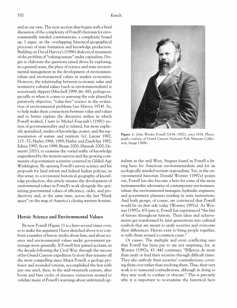
By now Powell (Figure 1) is a hero several times over,so to make the argument I have sketched above is to con-front a number of heroic myths about him, and about sci-ence and environmental values under government pa-tronage more generally. If Powell first gained acclaim, inthe decade following the Civil War, through the successof his Grand Canyon expedition (a story that remains allthe more compelling since Major Powell, a geology pro-fessor and wounded veteran, accomplished the feat withjust one arm), then, in the mid-twentieth century, afterboom and bust cycles of resource extraction seemed tovalidate many of Powell’s warnings about unfettered cap-
italism in the arid West, Stegner found in Powell a fit-ting hero for American environmentalism and for anecologically minded western regionalism. Yet, as the en-vironmental historian Donald Worster (1997a) pointsout, Powell has also become a hero for some of the moreinstrumentalist adversaries of contemporary environmen-talism: the environmental managers, hydraulic engineers,and government planners residing in state institutions.And both groups, of course, are convinced that Powellwould be on
their
side today (Worster 1997a). As Wor-ster (1997a, 43) puts it, Powell has experienced “the fateof heroes throughout history. Their ideas and achieve-ments get transformed by later generations into culturalsymbols that are meant to unify societies and overcometheir differences. Heroes exist to bring people together,to rally them around a common cause.”
Or causes. The multiple and even conflicting usesthat Powell has been put to are not surprising, for, asWorster (1997a, 43–44) continues, “[H]eroes do morethan unify or lead their societies through difficult times.They also embody their societies’ contradictions, cover-ing them over rather than resolving them. Thus, their verywork is to transcend contradictions, although in doing sothey may work to confuse or obscure.” This is preciselywhy it is important to re-examine the historical facts
Figure 1. John Wesley Powell (1834–1902), circa 1874. Photo-graph courtesy of Grand Canyon National Park Museum Collec-tion, Image 13686.

John Wesley Powell and the Mapping of the Colorado Plateau, 1869–1879 551
about our heroes and the contexts in which they worked.The point is not simply to invert the cultural symbolismby turning them into villains (cf. Hess 1997; see Worster1997b), but rather to recover some of the complexity—andsome of the still unresolved tensions and contradictions—that heroism “works to obscure.” Before I turn in greaterdetail to Powell’s career during the 1870s and the contra-dictions embodied in
that
work, I begin in this sectionthe task of opening Powell’s heroics—and, ultimately,his politics—to a geographical critique that emphasizesthe mediating role of science, surveys, and cartography inthe relations between Washington and the AmericanWest. At stake, then, is a reassessment of Powell’s place inthe historical geography of westward expansion and en-vironmental resource policy, and with it, an opportunityto raise questions that move beyond the vagaries of “en-vironmentalism,” “environmental values,” and “environ-mental sensitivity”—which Powell has since been associ-ated with—to ask more specifically about the historicallyand geographically embedded social processes throughwhich environments are valued.
Value and Environmental Values
Examining the relations between political values andenvironmental-ecological issues, Harvey (1996, 176) re-marks that not only is environmentalism capable of serv-ing a broad range of issues, cutting across the traditionalideological spectrum, but environmentalists “also canadapt to diverse political positions while claiming to bebeyond politics in any normal sense.” It is in this sense ofan environmentalism apparently rooted in the interestsof nature itself, rather than in specific sets of political, so-cial, or economic interests, that scientists and other pro-ducers of environmental knowledge have long had a spe-cial role to play. From the example of two soil scientistswriting in 1939 who made the racist, paternalist argu-ment that Africans were incapable of managing theirown soil resources, Harvey (1996, 182) identifies an ide-ology of environmental management whereby
in the name of the environment, all kinds of restrictionsshould be put upon the rights of “others” while conferringrights (and obligations) on those who supposedly have theknowledge and the high technology to control the prob-lem. While few would now dare to be so blatant [as theaforementioned soil scientists], there is a strong strain ofthis kind of thinking in World Bank arguments and even insuch a seemingly progressive document as the BrundtlandReport. Control over the resources of others, in the name ofplanetary health, sustainability, or preventing environmen-tal degradation, is never too far from the surface of manywestern proposals for global environmental management.
As Harvey’s half-century jump from the concerns of latecolonial European scientists to the Brundtland Report’s(World Commission on Environment and Development1987) recommendations for “our common future” sug-gests, while the discourses, contexts, and—by all means—knowledge of environments all change, there are impor-tant historical and geographical continuities to this ide-ology of environmental management as well.
4
Questionsof whom the environments are managed
for
and how sys-tems of value and values are reflected in legitimate andnormative environmental knowledge are equally valid forinterpreting late nineteenth-century anxieties over the“closing space” and diminishing resources of the NorthAmerican continent as for their mid- and late-twentieth-century planetary corollaries (see Haraway 1989; Brechin1996; Katz 1998; Neumann 1998).
Obviously, the point here is not to diminish or makelight of regional and global environmental problems,
5
whether contemporary or historical. Nor is it to discountthe possibilities of scientifically knowing environmentsin ways that may be or have at times been beneficial to theamelioration of those problems. Rather, I want to call at-tention (with Harvey 1974, 1996) to the complex rela-tions between the politics of environmental values, onthe one hand, and the social processes through whichvalue is attached to nature and environments, on the other.For Harvey (1996, 150), this means “coming to termswith dominant modes of valuation that were initiatedpractically with the development of capitalism and dis-cursively developed through Enlightenment politicaleconomy.” What Harvey (1996, 150–75) has in mindhere is more than just a story of nature’s commodifica-tion, but the pricing of nature as “natural assets” in moneyterms—as the only “universal yardstick of value”—is stillat the center of his formulation. “Money prices attach toparticular things,” writes Harvey (1996, 153; emphasis inoriginal), “and presuppose exchangeable entities with re-spect to which private property rights can be establishedor inferred. This means that we conceive of
entities
as ifthey can be taken out of any ecosystem of which they arepart.” This atomistic mode of valuation, contingent onproperty rights, is universal but highly unstable, as re-flected in the very instability of money as a representa-tion of value in market economies (Harvey 1996). How-ever, if environments are attached in this sense tosystems of value and circulation such that they are madesusceptible, in Smith’s (1990, 49) memorable phrasing,to capital stalking the earth in search of material re-sources, then how can natural assets be managed in waysthat go beyond the short-term interests of resource mar-kets so as to prevent environmental crises and catastro-phes and thus facilitate more long-term capital accumu-
552 Kirsch
lation? If there is a contradiction in this mode of valuingnature that would tend to make accumulation “unsus-tainable,” then how has it been resolved—if at all?
One resolution to this contradiction involves the so-cialization of environmental management. The long-term interests of capital accumulation could thus belooked out for, under publicly subsidized federal manage-ment, in their relations to specific environments, re-source bases, and so forth. The managers of resources andenvironments would then require certain kinds of envi-ronmental knowledge compatible enough with extantsystems of value to help them regulate, to a degree, theways that privately owned resources could be utilized, orto assist in regulating interaction between private enter-prise and the “public lands.” As I will show, Powell re-mains a complex historical figure because his ideas ap-peal to that twentieth-century ecological thinking thathas sought, in certain respects, to overcome the atomis-tic modes of valuing nature that Harvey identifies above(see also Mitman 1992); at the same time, Powell’s workcontributed to and was at times structured by the expan-sion of political-economic modes of valuation that facil-itated the often destructive work of value extractionfrom nature.
The extent to which environmental problems andlong-term interests can be adequately managed under asystem bracketed by this mode of valuation and policy isclearly a matter of debate. However, this dialectical lan-guage of contradiction and resolution offers us a theoret-ical foundation for understanding the development of in-strumental environmental resource management in thecapitalist state in general, allowing us to inquire furtherabout exactly whose long-term—and whose short-term—interests hold the greatest purchase in the regulation ofenvironments “on the ground.” And yet the story is alsomore complicated than that. For if, as Harvey (1996)suggests, claims to superior knowledge and technologyare indeed key leveraging points for those seeking therights and responsibilities of managing resources and en-vironments, then we need a better sense of how thisknowledge comes about, and how it comes to be embod-ied in particular institutions. In other words, the social-ization of specific forms of environmental managementis not at all guaranteed, but must itself be socially andculturally produced.
Governmentality, Washington Science,and the Traffic of Knowledge
It is useful at this point to articulate these concerns forthe valuing of environments with the development ofthe particular forms of state rationality that Foucault
(1991) labeled
governmentality
, a concept that speaks tothe historical emergence of “population” as understoodin its relations to health, wealth, territory, and other nat-ural and social elements, as a tactical field of governmentobservation and intervention. This is no simple matter,and I will not attempt to summarize it here.
6
For the pur-poses of this article, the point I wish to elaborate is thatthis new problematic of government—hinging on thetension between modes of observation used to constructa social or national body (for example, observation of the“regularities” of population dynamics through census-taking and statistics; see Hacking 1991; Hannah 2000),on the one hand, and the ability of the state, throughmeasured regulation, to produce governing “effects” thatimpel proper conduct according to principles of politicaleconomy, on the other—resulted in the formation ofnew bureaucratic apparatuses and the concomitant de-velopment of new forms of knowledge (Foucault 1991,102–3). This logic has been extended historically to ac-count not just for populations, but also for the construc-tion of knowledges detailing the “natural resources”available to them and, in some cases, in need of expertmanagement (see Braun 2000; Demeritt 2001). The roleof the state in the business of valuing of environments,then, becomes something more complex than that of aregulator between the short- and long-term interests ofcapital, for this very conflict of interests can be seen as aprocess constituted contingently and reciprocally withstate formation and the production of knowledge (Braun2000).
7
What is more, governmental observations andtheories of regulation—as “mediations” not only betweena field of observation and a (potential) field of state in-tervention but also, in terms of the positive and sociallygeneralized sense of power outlined by Foucault ([1977]1995),
8
between the authors of governmental knowledgeand a wider “public” audience—need not be directedsolely by the state itself.
In the Gilded Age capital of Washington, DC, wherethe increasingly centralized federal state, consolidatedunder the Republican party during the Civil War, wasbeing cast largely to promote Northern industry and fi-nance along with western expansion (Bensel 1990; Les-soff 1994), new apparatuses for observation and the pro-duction of just this kind of governmental knowledgetook root like never before in the U.S. (Hannah 2000).Much of the information collected for departments suchas those of Commerce, Treasury, Interior, Agriculture,and War had an explicitly geographical character, whetherdealing with spatial distributions of commercial activityand population or the regional surveys of the western ter-ritories that were accelerated (and later consolidated) soas to quite literally draw the arid lands of the West onto
John Wesley Powell and the Mapping of the Colorado Plateau, 1869–1879 553
the American map. At the same time, with this work ofgeographically ordering the western territories, for every-thing from topography, geology, and climate to such hu-man geographies as the distribution of Native Americanpopulations and language groups and the status of thevarious treaties in the region, the American map was, incertain ways, affixed to the territory itself.
I will return to this point later in the context of thePowell Survey to examine how fixing the map to the ter-ritory worked in practice, and how it failed to do so, forthis is the rub of Harley’s (1992, 532) “cartographic par-adox”—that mapped territory
becomes
one sort of spaceand not another. For now, the point is simply that the re-gional surveys performed a particular kind of mediationbetween Washington and the arid lands of the ColoradoPlateau. For there was more than a geographical char-acter to the observations, measurements, photographs,paintings, and ethnographic objects that were routedfrom the arid lands to Washington, where they could bereconstructed—and often made available for publicconsumption—in maps, books, popular magazines, sci-entific journals, and museum and exhibition displays.
9
The very movement of survey scientists, and the trafficof knowledge in which they engaged, was geographicalwork, and
only
through this traffic of knowledge—betweenWashington and the West, between science and govern-ment, between the natural and social sciences, and acrossthe threshold of the public sphere —did the West takeshape in Washington (Kirsch 1999). But “the West,” as anincreasingly refined cartographic object, was not theonly thing constructed by the maps, measurements, andreports of the surveys; the authority of the survey scien-tists themselves was also a product of their varied abili-ties to facilitate this geographical exchange.
Amongst the new cadre of predominantly male, middle-class, and former Union officers lucky enough to collectpaychecks as government scientists, it is hardly surpris-ing that a positive philosophy began to flower, best ex-pressed in the proceedings of Washington’s burgeoningscientific clubs and societies and in museum displays (seeHinsley 1994; Stocking 1994; Kirsch 1999; Pauly 2000),based on the bracing conviction that, given the chance,the collection, mapping, and analysis of social and envi-ronmental data would lead to a rational basis for socialand environmental control. While this advocacy of sci-ence (and scientists) in government was undoubtedlyself-serving, it was also not without its broader theoreti-cal and political justifications. Many in Washington’sscientific and intellectual community during the 1870sand 1880s were, like Powell, committed Lamarckianswho freely extended ideas about the inheritance of ac-quired characteristics into the realm of social processes
and institutions (Darnell 1969; Lacey 1993). And yetclear distinctions were made between the social and bio-logical processes of evolution (see Powell 1882; Ward[1883] 1911), and these distinctions were invested withpolitical implications concerning the role of governmentin public life. In a discussion of the “natural evolution ofindustry,” for example, while Powell (1881a, 43) arguedthat corporations were “the instruments through whichnearly all the operations of society would eventually beperformed,” he still, in an explicit rejection of then-popular Spencerian arguments for
laissez-faire
, cautionedthat “[T]hey require regulation, and . . . the principalwork of legislation would ultimately be the adjustment ofthe relations of corporations to the public and to eachother.” In the meantime, government science, dovetail-ing with this vision of regulatory government, could becharged with nothing less than to guide the evolution ofthe American nation (Lacey 1993; Kirsch 1999; Pauly2000).
10
So, as the continental frontier gave way to the“closed space” of the map, as Powell’s observations ofthe physiography and limited agricultural capacity of thearid lands were woven into his calls for more efficient us-age of land and water resources, science itself came to beseen—by government scientists like Powell (1882, 70),anyway—as the “olive branch of peace and the emblemof hope.”
What contradictions, then, might such a heroic senseof science cover over? Can the environmental valuesthat came out of Powell’s work, with their basis in scien-tific environmental knowledge, be understood apart fromthe optimizing discourses of value on which the work ofgovernmentality was made to turn? Or could scientificexpertise, in effect, substitute for politics—or at least fa-cilitate a just politics—for matters as complex (and, asmay seem to us today, inherently political) as the distri-bution of public lands, the distribution and managementof water for irrigation, and the social and political con-trol of Native Americans?
These questions are not the same as those posed byWorster about the meaning of Powell’s heroic legacy, butthey follow logically. For Worster (1997a, 44), it is thevery “contradictions of modernity” that Powell’s heroismcovers over: his devotion to scientific and technologicalprogress, efficiency, and improvement together with hisromantic sense of the sublimity of nature, the latterborne from the spectacular landscapes of deep geologicaltime that he encountered during his explorations of theGrand Canyon and Colorado Plateau. Powell’s drive forunderstanding and legislating the limits to the techno-logical control of nature in the West thus seems a fittingcompromise. It is in this sense that Worster (1997a, 44)adds that “[W]e moderns . . . are less prepared than he
554 Kirsch
was to reconcile [the ‘contradictions of modernity’,] norare we often even aware that the contradictions exist.”As suggestive as this proposition may be, the implicationhere—that
any
effort to reconcile society’s contradic-tions is laudable, so long as it is rooted in the presumablyshared environmental values of communitarianism, sus-tainability, and anticorporatism
11
—is troubling, becausethe
problem
with Powell, as I will argue, is precisely that heresolved the contradictions of his times, and of the westernlandscape, too easily; he more or less mapped them away.
From “Great Blank Space” to the 1874
Atlas of the Territories of the United States
The maps from Washington, that put down only what is ab-solutely, scientifically known, leave a great blank space hereof three hundred to five hundred miles long and one hun-dred miles broad. Is any other nation so ignorant of itself?
—Samuel Bowles ([1868] 1991, 107)
The “great blank space” of the Colorado Plateau in 1868was a cartographic construction; only when the outlineshave been mapped can an interior appear empty, readyto be written over with lines and names (Carter 1988).But it was no less real an opportunity for Powell, who wasbest known at the time, in the intellectual circles of cen-tral Illinois, as the self-educated professor of geology atIllinois State Normal University and the curator of theIllinois Natural History Society’s museum who had ledamateur natural history excursions to the highlands ofColorado during the summers of 1867 and 1868. For thechance to be the one writing over the great blank spaceof the Colorado Plateau—even as three government-supported surveys were ongoing elsewhere in the West
12
—Powell scraped together funding from a number of sources,including the Illinois Natural History Society and the Il-linois Industrial University, and arranged for free trans-port from the railroad companies and free army rationsfor his exploring party. In fact, these sacks of flour, bacon,coffee, sugar, and dried apples, together with a loan ofscientific instruments from the Smithsonian Institution,constituted the whole of Washington’s support for theexpedition. Still, as Powell and his crew of nine set out infour boats from Green River Crossing, it must have beenobvious to them that the expedition could only succeedin filling in the map of the Plateau by bringing the regionto Washington in the form of observations, measure-ments, and stories.
As Powell later recounted the experience of white-water rapids, boat wrecks, grueling portages, hunger, anddespair for the readers of
Scribner’s Monthly
, a popular
journal in which he serialized some of his geographicaland ethnological explorations (Powell 1875b, 1875c,1875d, 1875e), he stressed for his readers that the explorersthemselves almost failed to make it out of the canyons.In one scene from the first
Scribner’s
article, for example,we find Powell stuck on a nearly vertical cliff, which hewas ascending with boatman George Bradley to takebarometric readings, and hanging onto his life by his oneand only arm. “The moment was critical,” Powell (1875b,306) recalls: “[I]t occurred to Bradley to take off his drawers,which he did, and swung them down to me. I hugged closeto the rock, seized the dangling legs, and, with his assis-tance, was enabled to gain the top.” After this traumaticexperience, Powell (1875b, 306) adds, “[W]e walked outon a peninsular rock, made the necessary observationsfor determining its altitude above camp, and returned,finding an easy way down.”
“Necessary” observations! Here on the pages of
Scrib-ner’s
in 1875, more than in the subsidized supplies, is thenature of governmentality in Powell’s first expedition.
13
That is, the very idea that such a heroic commitment tomeasuring air pressure and mapping elevation could be
necessary
reflects a great deal about the seriousness withwhich the “need” for precise knowledge of the new terri-tory was integrated into the national imagination, for au-thors and readers alike. Moreover, once Powell arrived inWashington to report on his 1869 explorations to theCongress, the telling fact is not the minimal funding thatwas doled out before the expedition, but rather just howquickly Powell’s work was incorporated into the momen-tum of government-sponsored survey science afterwards.Trading on the publicity that the exploration of the Col-orado had garnered in the national media (many in thepress had speculated that the explorers were lost or dead),Powell wasted little time in finding continued supportfor his Colorado River survey, this time from the federalgovernment. On 30 August 1869, Powell disembarkedfrom the Colorado River, among six remaining in his ex-ploring party,
14
near what is now Lake Mead, Nevada.From there he found his way back to Illinois and, after anumber of public lectures, on to Washington. In July1870, an Act of Congress appropriated for Powell $12,000“for completing the survey of the Colorado of the Westand its tributaries,” though it was clarified for Powell that“No compensation, however, will be allowed for yourservices as Disbursing Agent” (letter from J.D. Cox toPowell, 11 March 1871, in Letters Received by Powell).
15
However, these funds did support an astronomer, an as-sistant astronomer, and a topographer for “the determi-nation of latitude, longitude, and altitude” (letter fromJ.D. Cox to Powell, 18 July 1871, in Letters Receivedby Powell), suggesting, following the limited scientific
John Wesley Powell and the Mapping of the Colorado Plateau, 1869–1879 555
results of the first expedition, that more disciplined ob-servations would now be expected in Washington. Thefollowing year, a sense of at least semipermanence wasattached to the project when Powell was allocated funds“[f]or
continuing
the completion of the Survey of the Col-orado of the West” and was, for the first time, given a sal-ary of “three thousand dollars ($3,000~)
annually
duringthe time you are engaged in this work” (letter from J. Henryto Powell, 11 March 1871, in Letters Received by Pow-ell; emphasis added). At this time, Powell was permittedto hire a photographer to “take such views as may be use-ful in illustrating the topography, geology, etc. of the regionsurveyed” (Henry to Powell, 11 March 1871).
16
Appropriations were thus maintained—and, at times,increased or decreased—one year at a time during the1870s for what was to become the “Geographical andGeological Survey of the Rocky Mountain Region,” orPowell Survey. Fieldwork along the Colorado River, andlater extending across the Plateau country in SouthernUtah, included trigonometric surveys, topographic map-ping, and geological investigations (and limited geologi-cal mapping; see Powell 1875a, 1876), but also surveys ofbotany and ornithology and—with perhaps the greatestzeal from Powell himself—surveys of native vocabulariesand grammar, social organization, arts and technology,mythology, and archaeology.
Two points can be made about this transition fromPowell’s 1869 exploring party to the Powell Survey proper.First, it is worth calling attention again to the escalationfrom the initial exploration of the Colorado Plateau toits more sustained survey and appraisal under govern-ment patronage. This escalation is not at all surprisinggiven the belated date of the exploration in the contextof ongoing settlement of the region, but the point is thatthe consequence of filling in the so-called blank spacewas to very quickly assert the need for more surveys andmore maps. Along with the Hayden, Wheeler, and Kingsurveys, its rivals for congressional funding at the time,the Powell Survey took up the cause of producing a na-tional “self-knowledge” of the western territories, a knowl-edge constituted by spatial information that its propo-nents categorically expected to be of practical value forthe army, the railroads, the Bureau of Indian Affairs, andvarious farming and mining interests. At the same time,this work contributed to the reserves of field experienceand collected information on which the expertise of sur-vey scientists such as Powell was based.
Second, the spatial
ordering
of information that re-sulted from this work was not merely a reflection of whatwas already “there” to be surveyed in the West. The car-tographic logic traveled with the field scientists. As De-partment of the Interior Secretary Columbus Delano in-
structed Powell in a letter of 1 July 1874 (LettersReceived by Powell):
In the prosecution of your survey, you will, when necessary,consult such Public Land surveys as have been made underthis Department, in the field of your work, for the purposeof connecting the established lines with your system of tri-angulation, and of accurately designating on your maps theposition of mineral claims. You will determine, as far as pos-sible, the boundaries of Territories and Indian Reservations,and mark the same by suitable monuments, and will ascer-tain the position of all agricultural lands, and of such min-eral lands as you may discover, by trigonometrical measure-ments, placing suitable monuments thereon for theguidance of the Surveyors General of the several Districtswhich may be explored.
If Indian reservations and mineral and agricultural landswere already there, then they were there in a chaotic state,at least when viewed from the outside. Only by connect-ing them to “the established lines” of trigonometric sur-vey, and by establishing monuments to connect the ab-stract space of the map to the particular physical space ofthe landscape, could their identity be fixed in place. “Itwill be borne in mind,” Delano’s letter continued, “thatthe ultimate design to be accomplished by these surveys, isthe preparation of suitable maps of the country surveyed,for the use of the Government and of the nation, whichwill afford full information concerning the agriculturaland mineral resources and other important characteristicsof the unexplored regions of our Territorial domain.”
The logic of the instructions was to produce a set ofscaled regional pictures of the West that could be sentback to Washington for evaluation and eventual publi-cation, so that the maps and reports could ultimately bemade available to “the nation” to facilitate the settling ofthe region and the exploitation of its resources. This wasthe cartographic ideal, anyway, that gave the extendedmetaphor of filling in the map such resonance, much asEdney (1997, 25) describes the reputedly standardizedmapping of British India, by which “particular variationsand contingencies were subsumed within a ‘house ofcertainty.’” Since the settlement and capitalization ofthe arid West were
already
occurring—in the Powell Sur-vey’s “territory” in Southern Utah, as an endeavor highlycircumscribed by Mormon Church authorities in SaltLake City—the symbolic work of cartography also de-pended on the status of survey science as practical work.As such, there were practical questions to face: How, ex-actly, was the region to be scaled down? And what if themaps produced by the four western surveys directed bythe War Department and the Department of the Interiordid not show the same “important characteristics,” or werenot easily combined as part of the same mapped world?
556 Kirsch
In 1874, these problems were to be resolved through anew
Atlas of the Territories of the United States
, to be pro-duced under the Department of the Interior.
17
As autho-rized by Congress, the western surveys were now to be“conducted on a uniform system,” oriented towardsthe preparation of the
Atlas.
The new “instructions for thegovernment of the Geological and Geographical sur-veys” created two classes of maps to be produced, “gen-eral” and “special” (Delano 1874). The general maps werefurther subdivided into topographical and geological, bothto be made on a scale of four miles to an inch (1/253,440),and to be composed on sheets “twenty-six (26) incheslong by thirty-seven inches wide—including the bor-der, & to be folded once” (Delano 1874). Each generalmap would thus represent an area two and a half degreeslongitude by one and one-fourth degrees latitude. Spe-cial maps could be graphed at variable scales and wereto be made explicitly for the “purpose of properly repre-senting mining districts; mineral, agricultural, pasture,or timber lands; or for other special purposes” (Delano1874). In addition, steps were taken to ensure coopera-tion and to “respect the fields of operation” betweenWar Department and Interior surveys (letter from W.Belknap to C. Delano, 23 July 1874, in Letters Re-ceived by Powell).
That the
Atlas
itself was never completed does notdetract from the importance of the event, for as we willsee, these “instructions for the government of the sur-veys” were translated into future work in the PowellSurvey (including the 1878
Report
), and the
Atlas
project was essentially swallowed up by the subsequentconsolidation of the four western surveys into theUSGS. The effort to create a uniform system of cartog-raphy for the
Atlas
, and for the prosecution of the west-ern surveys more generally, reflected an increased de-mand in Washington for a spatially
legible
West thatwas tied as a matter of course to the prescriptive natureof the surveys. As the instructions for creating “special”maps for a class of productive lands suggests, in themapping of the American West, the complex relationsbetween spatial representation and reality were made toturn largely on issues of optimal land-use. If the blankspaces of the map made mapping, and then
more
map-ping, seemingly inevitable, then this process of fillingin the map—and the perception of closed spaces orfrontiers—also called Powell’s attention, as we will see,to a new age of limits to expansion and a correspondingneed for the efficient management of land and other re-sources.
18
And so often obscured by the very idea of op-timal land-use—and by the experts who justified thatcategory—was the political question of just
who
was tobe allowed to use the land optimally.
Geographical Solutions
State Projects of Legibility and Simplification
To say that the implementation of new policies forthe western surveys reflected a demand for increased spa-tial legibility of the region in Washington contains, as itscorollary, the suggestion that postbellum Washingtonwished to turn U.S. westward expansion into a more leg-ible process than it had been heretofore. I take this em-phasis on legibility from Scott, who argues in his book
Seeing Like a State
(1998, 1–83) that modern state func-tions as diverse as the standardization of weights andmeasures, cadastral surveys, scientific forestry, and thecreation of permanent last names can all be understoodas “state projects of legibility and simplification.” “Ineach case, officials took exceptionally complex, illegible,and local social practices,” writes Scott (2), “and createda standard grid whereby it could be centrally recordedand monitored.” For Scott, this move—from the com-plex, illegible, and local to the comparatively simple,legible, and national—is necessarily a reductive process,geared explicitly towards the representation of
what in-terests the state
, and it is thus tied closely to the surveil-lance, regulation, and control of both people and envi-ronments. Only by achieving a “synoptic view”—precisely
because
it is selective and partial—can the state, in turn, im-pose its own logic of simplification on the reality observed.
19
The “crowning artifact” of these state projects of legi-bility, Scott (1998, 35) argues, is the cadastral map, for“the very concept of the modern state presupposes avastly simplified and uniform property regime that is leg-ible and hence manipulable from the center.” His discus-sion of property mapping is important here because itbears directly on the relations among the perception ofclosed spaces, the production of value, and the mappingof the American West.
As long as common property was abundant and had essen-tially no fiscal value, the illegibility of its tenure was noproblem. But the moment it became scarce (when “nature”became “natural resources”), it became the subject of prop-erty rights in law, whether of the state or of the citizens.The history of property in this sense has meant the inexora-ble incorporation of what were once thought of as free giftsof nature: forests, game, wasteland, prairie, subsurface min-erals, water and watercourses, air rights (rights to the airabove buildings or surface area), breathable air, and evengenetic sequences, into a property regime. In the case ofcommon-property farmland, the imposition of freehold prop-erty was clarifying not so much for the local inhabitants—the customary structure of rights had always been clearenough to them—as it was for the tax official and the landspeculator. The cadastral map added documentary intelli-
John Wesley Powell and the Mapping of the Colorado Plateau, 1869–1879 557
gence to state power and thus provided the basis for thesynoptic view of the state and a supralocal market in land.(Scott, 45)
What Scott clarifies in this “history of property” is achanging economy of nature and space in which the stateinsinuates itself at the center chiefly through the imposi-tion of new classes of boundaries. Of course, the ability todraw a map means little without the power to project it(e.g., the new property regime) onto the earth’s surface.However, in recognizing that mapping and boundary-making strategies were essential to the need for legibilityat
supralocal
scales, we gain a better sense of just how car-tography has worked as a language of state rationalityand power. Cadastral maps, in intensively settled regions,and geological and geographical surveys, in sparsely pop-ulated regions (especially recently colonized areas), facil-itate the reification of a particular ordering or reorderingof physical and social space precisely at moments of up-heaval in property relations.
And yet, important differences obviously exist be-tween the cadastral survey and the kind of survey in whichPowell was engaged. Scott (1998, 49) notes, for example,the distinction between intensive and extensive landuses, as the latter commonly corresponded, in coloniallands, with the presence of indigenous peoples, but hestill places them under the same rubric of legibility andsimplification:
Where the colony was a thinly populated settler-colony, asin North America or Australia, the obstacles to a thorough,uniform cadastral grid were minimal. There it was a ques-tion less of mapping preexisting patterns of land use than ofsurveying parcels of land that would be given or sold to newarrivals from Europe and of ignoring indigenous peoplesand their common-property regimes.
But this is not quite right. Although the notion that suchcommon-property landscapes were socially empty—asdefined by the fact that they were not productive formarket exchange—was indeed, as Scott (368 n. 99) ar-gues, a powerful idea in the appropriation of native landsin places like Australia, New Zealand, Argentina, andNorth America, this appropriation was not achieved somuch by ignoring previous property regimes as it was—inwestern North America, at least—by turning the peopleand their institutions into objects of study. To paraphraseBrealey (1995), it is in this sense that indigenous peoplecould be mapped into antiquity at the same time as theywere mapped out of their communal social space. Throughethnology, people, too, could be made legible, and theirartifacts, vocabularies and grammars, and censuses of theirabsolute “numbers” and locations packed off to Washing-ton for evaluation with the rest of the traffic of knowledge.
I suspect that few of these arguments about the con-
struction of a legible West—including the simplifica-tions of nature, societies, and space that were necessaryto render them more manageable—would have been verysurprising to Powell and his colleagues during the 1870s.Indeed, the point of the western surveys was to make
lim-ited
observations, through established methods of trigo-nometrical survey, barometric readings, photography, andso forth, to produce topographical and geological maps,or to construct grammars of native languages to producephilological maps, so as to rationalize control, commodi-fication, and exploitation of the region. The expeditionaryskills of field science necessary to map and measure theWest and the wisdom or judgment necessary to deter-mine what was important about the region surveyed jus-tified the governmental demand for Powell’s expertise inWashington. “There must be some method of selecting,some method of determining what facts are valuable, andwhat facts are trivial,” Powell (1882, 68; emphasis origi-nal) would later harangue. “The fool
collects
facts; thewise man
selects
them.” And what is a map or a regionalsurvey if not a spatial model of selected features? It wasonly through selectivity that a “synoptic view” of theWest could be achieved. When the basis of selectivitywas cast in terms of scientific expertise, for the geologicalas well as the ethnological surveys, then the reorganizationof nature and space—and, with it, the history of property—could more easily be seen as objective and apolitical.
Counting and Collecting 10,347 Indians
Early in 1874, Powell was asked, in testimony for theCommittee on Indian Affairs, about the origins of his in-terest in ethnology. “I was interested in some surveys ofthe Colorado of the West and explorations there,” he(1874, 3) offered, “and in that way I became interested inthe language and studied it.” Indeed, Powell’s survey work,which included numerous visits to the native “tribes,”“bands,” and pueblo villages on the Colorado Plateauduring the first years of the 1870s, extended easily fromthe geological to the ethnological; he was exploring theland, it seems, and they just happened to be there. Infact, however, the project of making an ethnological oranthropological survey of the region was, like the specialand general maps Powell was instructed to completeunder the Department of Interior, an effort to render theplace legible through limited observation so that it couldbe rationalized and controlled. At the same time, notonly was the inclusion of indigenous peoples in the sameanalytical field as rocks and landforms essentially com-patible with the natural historical and evolutionary sci-entific traditions (see Jardine, Secord, and Spary 1996),the geographical “overlap” of these interests in the field
558 Kirsch
in the course of practical government survey work pre-sented few epistemological problems, if any. Powell seemsnever to have doubted, for example, that his investiga-tions would contribute both to evolutionary studies oflanguages and their diffusion and to practical questionsconcerning which tribes could be placed together on res-ervations (Darnell 1971, Hinsley 1994, Kirsch 1999; see,e.g., Powell 1881b, 1881c).
Powell had been appointed a special commissioner ofIndian affairs in 1873. As he reported to the Committee,in that capacity he engaged, along with Special Commis-sioner George Ingalls, in a census of Numic-speaking In-dians (primarily Ute, Paiute, and Shoshone tribes) in theinterior West.
20
The intent of their work was to make aninventory of the number and location of Indians in theregion and, on the basis of field observations, to recom-mend how to re-organize the treaty and reservation sys-tem with those tribes most efficiently so as to ease con-flicts with white settlements. Powell and Ingalls visitedsixty-six tribes in the region in the summer of 1873, find-ing “every man, woman and child” among them, count-ing 10,347 Indians, roughly half of whom were living onreservations (Powell 1874, 3). It is an oddly precise num-ber, given the fact that, by their own estimate, they visitedbut half the tribes of the region, besides which, despite Pow-ell’s certainty, it would have been quite impossible to countall of those who did not wish to be counted, especially offthe reservations. Clearly, however, Powell was after preciseinformation, so that his policy recommendations might beplaced on something of a scientific footing.
21
As Powell (1874, 8–9) described the status of thetribes to the Committee on Indian Affairs:
There are over 120 tribes of them altogether. They are di-vided into little bands of from 40 to 300 in each band. . . .The land was all divided among these Indians and over 120governments formed, and to treat with these Indians andmanage them is to deal with 120 chiefs or political organi-zations. Their condition is something like this: They havebeen whipped pretty thoroughly and they do not want tocome in conflict with the government, and fully appreciatethe necessity for them to cultivate the soil. The greater partof that country, except Colorado, is almost destitute ofgame. Nevada and Western Utah are as thickly settled . . .[as] Indiana and Illinois in proportion to their agriculturalcapacities; perhaps more so.
The main problem—which Powell tied to broader issuesof settlement and limited agricultural capacities in theArid West—was that the Indians were being crowdedout of their lands, and in the destruction of game theyhad lost much of their livelihood. As a result, most hadbeen left destitute: “They gather some seeds; beg some;pilfer a little, and live in that way” (Powell 1874, 10).
Powell’s solution to this problem—the problem of theIndian “condition”
as
a problem of government—was ageographical one, couched in the paternalistic languageof helping the Indians to help themselves. He called fortheir complete removal to reservations so as to separatewhites and Indians
in space.
22
He appealed for funds toinduce the Indians to the reservations with promises ofland, livestock, and housing.
It seems to me that collecting them on these agencies is todo away with the evils arising from the menace of whitesand Indians together. The presence of 75 Indians scatteredthrough a community is sure to bring on difficulties, but re-move them to one point by themselves and a great majorityof these causes of difficulty will disappear (Powell 1874, 46–47).
To further improve efficiency, Powell also recommendedthat the number of federal Indian agencies in the regionbe reduced from eight to four. With this rationalized,more legible system for managing the Indians, Washing-ton would theoretically deal with 4 governments, insteadof 120.
23
Yet having witnessed the conditions at theagencies firsthand, Powell was aware of some of the prac-tical obstacles that his system would face. The MohaveReservation, for example, where nearly 2,500 Paiuteswere to be “collected,” included 185,000 acres of land,but Powell noted that most of the territory was composedof desolate, barren mountains, with the exception of tenor twelve thousand acres suited to agriculture. At theUintah Reservation in eastern Utah, 550 Utes were “onlynominally there . . . as they do not remain there becausethey are not fed” (Powell 1874, 27).
As objects of state projects of legibility and simplifica-tion, people clearly presented rather different problemsthan something like a forest; to paraphrase Scott (1998,24), trees were not themselves political actors, peoplewere. For example, Powell learned in September 1873that Kanosh, chief of the Pahvant Utes, “at presentdoesn’t
feel
like moving to Uintah this Fall” (letter fromT. Callister to G. Ingalls and Powell, 10 September 1873,in Letters Received by Powell; emphasis added). Never-theless, Powell envisioned a system of social controlthrough spatial strategies of concentration and height-ened visibility that would render the tribes more easilymanaged (see Hannah 1993). Moreover, in a moment ofsheer governmental optimism, Powell (1874, 43) assertedthat this new order was possible
solely
with inducements—west of Colorado, at least—without the threat of vio-lence to force the Indians to move: “I think that weought to withdraw every soldier from that territory. Ithink that if we would use one-fifth of the money nowspent on the military force for subduing the Indians, in
John Wesley Powell and the Mapping of the Colorado Plateau, 1869–1879 559
subduing them in another way the question could be set-tled without any difficulty at all.”
Then, for perhaps the only time in Powell’s lengthytestimony, a trace of the Indians themselves seems tocome through, as Powell (1874, 44–45) adds: “The wordsoldier has become a bug-a-boo to the Indians. The oldwomen use it to frighten the children. They think thema strange race of men, whose business is to kill people;who care nothing for social life and have neither wivesnor children. Their presence is a standing menace and isa source of trouble and disease.” This comment hints at a
history
of government violence against Indians in the re-gion (while also casting Powell in the sympathetic rolethat he envisioned for himself as a special commissioner).Yet this history of violence is precisely what is excludedfrom Powell’s plan; not mentioned in his testimony, forexample, was the fact that the “Blackhawk War” (1865–1867) had immediately followed the extinguishing ofIndian land rights in the Utah Territory and their at-tempted removal to the Uintah reservation in the firstplace (O’Neil and Sylvester 1969; Nielson 1998). It isnot that Powell was unaware of the violence that wentinto the making of the places he encountered, nor eventhat he was not genuinely concerned with the Utes’plight, but rather that this history was
irrelevant
to the spa-tial logic of his work. The present condition of the tribes(“whipped pretty thoroughly”) stands in for historicaldynamics because this is the nature of the census as a sta-tistical account of where people are at one moment intime. Throughout the transcripts of Powell’s testimony,there are parenthetical stage directions where Powell re-fers to a map of Indians, agencies, and reservations in theterritories. These are necessary gestures for Powell, be-cause counting and collecting 10,347 Indians is a storybest told spatially.
Of course, since the conditions that Powell observed
were
historically (as well as geographically) constitutedthrough relations of power and violence, it is not surpris-ing that the logic of his proposed system should breakdown where questions about land use and property rightsremained in question. In this respect, Powell (1874, 30)noted that “There are certain complications about theIndians of Colorado.” The problem was that the Utes ofwestern Colorado Territory had achieved a favorabletreaty acknowledging their rights to 13 million acres, oralmost the entire region west of the Rockies (roughlyone-third of the state), in addition to a substantial cashpayment. However, recent discoveries of gold and silverin the area, in addition to excellent timber, agriculturalpotential and other mineral resources, had initiated a re-consideration of the treaty by the federal government.Though a newer treaty had been struck which withdrew
some of the land from the Reservation on which therewere mines, there was no way, Powell argued, of pre-venting white miners and settlers from scouring the restof the region, which would, in turn, lead to the problemsassociated with the failure to separate whites and Indiancommunities in space. As Powell (1874, 31–32) saw it:
It is impossible to keep white people out or to protect 1500or 1600 Indians in the possession of 13,000,000 acres ofland where there is gold, silver, iron, coal, petroleum andforests. . . . There is some excitement about these mines.There were a great many people out there last summer pros-pecting the country and I have every reason to believe thatnext summer there will be three where there was one last.They will crowd out the Indians unless they are protectedby a great fence.
If there was any inclination to leave this land to theUtes, then, the expense of maintaining the Utes’ landrights in Colorado made the treaty untenable (“You can-not stand by the promise,” Powell [1874, 39] advised). Ina practical sense, as Powell’s allusion to the great fencemade clear, it was unthinkable. It is important to recog-nize that it was as much in his recognition of the practi-cal
limits
of government as in his recognition of itsstrengths that Powell advocated this consolidation of thereservation system. As Powell saw it, given the necessityof westward expansion and settlement, the reservationwas the best place for Indians to maintain a survivableresource base, under U.S. government protection, asthey necessarily shifted to farming for their living.
And yet Powell also recognized, despite this ideal,that the Utes living in Colorado would not be easily “col-lected.” In contrast to the status of those in Utah, “TheseIndians do not want to cultivate the soil,” he (1874, 32–33) said. “They have never been whipped. We havenever had any war with those Indians. They have not feltthe power of the government and want to keep theircountry.” Powell also noted that the Colorado Utes werearmed, and known for their horsemanship and the qual-ity of their horses. There had been indications that therewould be a war, as there had been, in fact, since Powellhad begun his work in the West in 1868 as an amateurnatural historian; violence had always existed simulta-neously with the surveys. Yet while this present threat ofviolence could not be excluded from Powell’s Indiancensus of 1874, Powell did rationalize breaking the treatywith the Utes in Colorado, and their removal to a smallerreservation, not by reason of military conquest but ratheron the basis of their failure to exploit the land optimally.At least this was the logic elaborated in his 1878
Reporton the Lands of the Arid Region of the United States, With aMore Detailed Account of the Land of Utah.
560 Kirsch
Legibility, Value, and the“Physical Characteristics of the Arid Region”
If, in Powell’s census work for the Bureau of IndianAffairs, producing spatial legibility of the Utes, Paiutes,Shoshone, and other native people living in the interiorWest was a necessary step in information gathering to-wards the
apartheid
solution that he proposed, then thiswork needs also to be understood as part of his larger-scale geographical solutions to the problems of settle-ment, order, and value in the “Arid Region” as a whole.
24
As Powell ([1878] 1962, 8) put it frankly in his preface tothe
Report
, “It was my purpose not only to consider thecharacter of the lands themselves, but also the engineer-ing problems involved in their redemption, and furtherto make suggestions for the legislative action necessaryto inaugurate the enterprises by which these lands mayeventually be rescued from their present worthless state.”
25
What sets Powell apart from most of his contemporarieswas his position that this redemption should be accom-plished without degrading the environment as a long-term productive resource, on one hand, and without fur-ther empowering capitalist irrigation companies, landspeculators, and other corporate interests, on the other.Powell is a populist in this project—he speaks in the in-terests of “individual farmers,” “men of small means,”and “poor men”—and there are undoubtedly importantlessons from his fusion of what we might call scientificadvocacy with populist interests. However, Powell’spopulism resides chiefly in a particular vision of govern-ment
science.
The
Report
—as, it would turn out, the finaltreatise of the Powell Survey’s decade of work on theColorado Plateau—was a product of Powell’s organiza-tion and synthesis of survey knowledge in Washington.As such, it reflects a strong wish for the traffic of knowl-edge to move in
both
directions, so that the ideas of gov-ernment scientists in the capital could be fixed to thearid region itself through land classification and regula-tion of property regimes, as a means of promoting ratio-nal land use.
In the political context of the Hayes administration’sreform platform, Powell thus intended, on the authorityof the regional scientific expertise of his survey, “to setforth the characteristics of these lands and the condi-tions under which they can be most profitably utilized”([1878] 1962, 16). According to Stegner (1962, xvii,xxiv), the resulting
Report
was a “revolutionary proposalfor the classification, survey, and disposal of the westernlands” and “the classic statement of the terms on whichthe West could be peopled.” However, this statement de-mands closer scrutiny, for even as Powell’s ecologicalsensibility may hold important historical lessons for re-
source managers and land use planners, there are impor-tant silences in Stegner’s reading of Powell that ulti-mately obscure the (actually rather clear) spatial andgovernmental logic of the
Report.
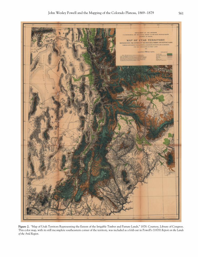
The
Report was meant as a general description of andprescription for the Arid Region as a whole, encompass-ing roughly 40 percent of U.S. territory, but it focusedempirically on the lands of the Utah Territory; Powell’s([1878] 1962, 16) philosophy was to “discuss first a some-what limited region in detail as a fair type of the whole.”Thus, as illustrated on a color-coded, fold-out map of theUtah Territory (Figure 2) tucked into the back of the Re-port, Powell divided all lands into three “great classes”:irrigable, timber, and pasturage. Irrigable lands, shadedgreen on the map, included only low-lying areas close tostreams, a quite limited area which, in Utah at least, con-stituted just 2.8 percent of the land surface. Located inthe higher plateaus and mountains, timber lands covered23 percent of the territory, though just 12.5 percent ofthis was constituted by standing timber; the map madethis contrast all the more striking by shading standingtimber in blue and the “Area of Timber destroyed byFire” in red. Everything in between the low irrigablelands and the high timber regions was called pasturage,though the quality of these lands for livestock grazing wasacknowledged to be highly variable. In addition, Powellincluded two special classes of lands: coal and mineral.The entire Arid Region, Powell argued, should be classi-fied in this manner—at minimal expense, save for thegeological mapping of coal regions—through more ex-tensive survey work.26
The Report was an extraordinary “state project of legi-bility and simplification,” spanning a key moment in thetransition from “nature” to “natural resources” in the AridRegion; it was extraordinary, that is, in so far as it com-plicated the project, to a degree, by developing a moregeographically sophisticated field of observation and in-tervention than the “arbitrary” rectangular system thatpreceded it ([1878] 1962, 50). In counterpoint to thegeometric, Jeffersonian grid of 160-acre homestead farmsdeveloped in the context of the humid eastern half of thecontinent, Powell argued, the arid lands of the West de-manded a different land system, one that recognized notonly the limited agricultural capacity of the region butalso the vital importance of water rights to production.Powell’s land system conformed to topography, not ge-ometry. He proposed that irrigable farmlands be parceledinto smaller, 80-acre, irregularly shaped units that wouldmaximize access to streams, while pasturage farm home-steads should be enlarged to 2,560 acres, also parceledinto irregular units to match the shape of the land (andpreferably with a small, contiguous piece of irrigable land).
John Wesley Powell and the Mapping of the Colorado Plateau, 1869–1879 561
Figure 2. “Map of Utah Territory Representing the Extent of the Irrigable Timber and Pasture Lands,” 1878. Courtesy, Library of Congress.This color map, with its still incomplete southeastern corner of the territory, was included as a fold-out in Powell’s (1878) Report on the Landsof the Arid Region.
562 Kirsch
Powell’s system of land classification was thus in-tended as the foundation of a new system for ordering“private entries” into the public lands in the Arid Re-gion, a system that he hoped to operationalize throughthe congressional bills included in the Report’s secondchapter that authorized the organization of new, commu-nally managed irrigation and pasturage districts of home-stead settlements.27 “Practically, all values inhere in thewater,” he argued ([1878] 1962, 50), “and an equitabledivision of the waters can be made only by a wise systemof parceling the lands; and the people in organized bodiescan well be trusted with this right, while individualscould not thus be trusted.” Powell recognized that indi-vidual property rights, under extant forms of regulation,contributed to the susceptibility of arid regions to prob-lems of capital agglomeration, a process that was alreadybecoming apparent, in parts of the settled West, whereirrigation companies acquired water monopolies ([1878]1962, 53; see Worster 1985).
For his biographer Stegner, who also edited the endur-ing 1962 edition of the Report, Powell’s blend of environ-mental knowledge, anticorporate populism, and trust ingovernment, local and federal, became the stuff of hero-ism, a recipe for the making of environmental valuesrooted in the American Western experience. Powell’sconcerns about the future of the Arid Region resonatedwith the West that Stegner knew in the mid-twentiethcentury (Worster 1997a), and the Report became, forStegner, the basis for a grand counterfactual of environ-mental values—all the more poignant for the fact thatPowell’s bills (and his land system) were ultimately ne-glected by Congress. Yet in Stegner’s (1992, viii) telling,with its slightly naive rallying cry of if only we had listenedto Powell bubbling up from the past, Powell’s “attempts toimpose order on whatever he touched, and especially onthe development of the western states whose problemshe knew as no one in his time knew them” are cut onlyinto the heroic figure of Powell himself, the “personifica-tion of an ideal of public service.” Powell, writes Stegner(1957, xiii–xiv), “added whole new branches to scienceand revitalized others, and created federal bureaus dedi-cated to practicing them in the public interest.”28 The“public,” however, has a rather expansive role to play inall of this: government scientists produce expert knowl-edge of the public lands in the public interest, and this pub-lic service results in the apparently obvious public good ofbeneficent government science determining the mostappropriate uses of the public lands. For Stegner, Powell’sheroism rests on this rather murky sense of a public inwhose interests Powell speaks, by virtue of his wisdom,values, and scientific objectivity. But who counts asthe public (Marston 1990; Mitchell 1995)? Plainly not the
native people that Powell had counted in the region justa few years earlier, including those who were dispossessedof their communal lands so that those lands could bemade “public” in the first place.29 Indeed, when we addto Stegner’s notion of “the public interest” the economic,“free-market” sense of publicity—that is, in terms of aninstitutionalized land market—it is clear how the verycondition of publicity might serve to underwrite the dis-possession of Indian lands.
Clearly, were it up to Powell (and of course it mattersa great deal that ultimately it was not), the process of as-signing value to nature and space in the western territo-ries would have been regulated in quite different waysthan it has been, reflecting not only a greater concern forlong-term environmental degradation but also some ofthe populist, anticorporate ideas that have been noted.However, it is also important to recognize in Powell’s Re-port the ways that his geographical solutions were struc-tured, as if by unwritten rules, by what I have called thegovernmental values of efficiency, order, and productiv-ity. In his first chapter on the “Physical Characteristics ofthe Arid Region,” Powell ([1878] 1962, 37) argues thatthe “growth and prosperity of the Arid Region will de-pend largely upon a land system which will comply withthe requirements of the conditions and facts briefly setforth.” Yet included with these “physical characteristics”is the land classification system described above, and theentire chapter is so thoroughly imbued with the languageof value (e.g., of grasses in pasturage lands, timber, and ir-rigation farming in general; cf. [1878] 1962, 16, 24–25,27, 29–30, 32) as to make categories of future economicworth and worthlessness inseparable from the observedphysical characteristics of the land.
This infusion of optimizing governmental values intonature is nowhere so clear as in Powell’s discussion oftimber resources in the region, for here questions of landuse converged with the problem of still “uncollected” In-dians that Powell had dealt with in his earlier work as aspecial commissioner. Though the timber areas showedevidence of heavy deforestation from forest fires—asdemonstrated, Powell indicated ([1878] 1962, 26), witha “glance at the map of Utah” (Figure 2)—Powell be-lieved this problem could be resolved through more ef-fective management. For this, he drew on his field expe-rience in the contracting spaces of the West ([1878]1962, 28):
In the main these fires are set by Indians. Driven from thelow-lands by advancing civilization, they resort to the higherregions until they are forced back by the deep snows of win-ter. Want, caused by the restricted area to which they resortfor food; the desire for luxuries to which they were strangers
John Wesley Powell and the Mapping of the Colorado Plateau, 1869–1879 563
in their primitive condition, and especially the desire forpersonal adornment, together with a supply of more effec-tive instruments for hunting and trapping, have in late years,during the rapid settlement of the country since the discov-ery of gold and the building of railroads, greatly stimulatedthe pursuit of animals for their furs—the wealth and cur-rency of the savage. On their hunting expeditions they sys-tematically set fire to forests for the purposes of driving thegame. This is a fact well known to all mountaineers. Onlythe white hunters of the region properly understand whythese fires are set, it being usually attributed to a wanton de-sire on the part of the Indians to destroy that which is ofvalue to the white man. The fires can, then, be very greatlycurtailed by the removal of the Indians.
Thus, while Powell argued that the Indians’ use of firewas not malicious—not a “wanton desire” to assault valueitself—he also argued that it was plainly irrational fromthe standpoint of optimizing resource use in the Arid Re-gion.30 And he ([1878] 1962, 29) was quite clear aboutfor whom, and for what kind of new economic geogra-phy, the forests were to be protected:
[O]nce protected from fires, the forests will increase in ex-tent and value. The first step to be taken for their protec-tion must be by prohibiting the Indians from resortingthereto for hunting purposes and then slowly, as the lowercountry is settled, the grasses and herbage of the highlands,in which fires generally spread, will be kept down by sum-mer pasturage, and the dead and fallen timber will be re-moved to supply the wants of people below. This protec-tion, though sure to come at last, will be tardy, for it dependsupon the gradual settlement of the country; and this againdepends upon the development of the agricultural and min-eral resources and the establishment of manufactories, andto a very important extent on the building of railroads . . .
“A division of labor is necessary,” Powell ([1878] 1962,35) added, “and special timber industries will be devel-oped, and hence the timber lands must be controlled bylumbermen and woodmen.” By setting total limitationson the practices of the displaced Indians, then, the for-ests and other lands in the region could be put to wiseruse, without limitations.
If there is a contradiction here, then it is resolved, forPowell and implicitly for Stegner, by the logic of optimalvalue. It is curious to note that, despite a flurry of edito-rial footnotes in the Report (for example, [1878] 1962, 27n. 4, criticizing Powell’s claim that “no limitation to theuse of the forests need be made” from a conservationstandpoint), Stegner has no comment at all concerningany of Powell’s calls for the removal of Indians from tim-ber areas (cf. [1878] 1962, 28–29, 35, 113). This aspectof the Report—and of the land system that Powellplanned—has largely fallen out of the received story of
Powell’s career, or worse, has been dissolved into Pow-ell’s “insatiable curiosity” about the inhabitants of the“blank places on the map” (James 1979). The mobiliza-tion of scientific expertise, whether in the interest of en-vironments or that of future generations of Americansliving in the Arid Region, thus appears as something sepa-rate from the processes of conquest and dispossession.This speaks precisely to the question of what heroismworks to obscure. And by seeing Powell chiefly as a heroof environmental values, we tend to lose sight of the con-texts in which he worked, and of the questions to whichhe spoke. How, Powell asked, should the Arid Region bevalued, classified, and redistributed? How should thelands be governed so as to optimize the worth of the ter-ritory from within, for the benefit of the social and polit-ical body of the U.S.? And how can scientific knowledgeof the arid environment (and of the people living there)contribute to the realization of these goals?
And so, having elaborated the highly contextual andontologically inseparable quality of the discourses ofvalue and of natural environments in Powell’s Report, wereturn to Harvey’s (1996) point: that control over the re-sources of others, justified in terms of preventing envi-ronmental degradation or maintaining “sustainability,”is a powerful subtext underlying many western proposalsfor environmental management. Indeed, it is but a shortstep from Powell’s rationale for the “land system neededfor the arid region” to say that, for example, the Utes ofWestern Colorado are wasting resources through theirextensive land-use practices, or, for that matter, thatthey have no interests in mining and therefore no legiti-mate claims to the gold and silver on the 13,000,000acres promised them in Western Colorado. The “termson which the West could be peopled” (Stegner 1962,xxiv) depended on the reorganization of the West’s ear-lier inhabitants and their inefficient land-use practices,and the language of value—that is, of future worth—whether expressed through land-classification maps orcalls for forest protection, provided a useful grammar forthis kind of work, for Powell as well as for his eventualopponents in government, because it was so readily ac-cepted as to seem a natural part of the map and the phys-ical landscape alike.
And yet, in reality, of course, important differencesexisted between the map of the Colorado Plateau coun-try and the place itself. While a decade of work by thePowell Survey could be used to bring the Arid Regionback to Washington—in bits and pieces, observationsand measurements, maps and photographs—and thus tospatially reconstruct the place as a field for strategic gov-ernment intervention, the move from the map of geo-graphical, geological, and ethnological features to the
564 Kirsch
map of proper land use—the move from Washingtonback to the territory—was at times hotly contested. Eventhough Powell, in his geographical solutions to the prob-lems of western settlement, could appeal to the logic ofvalue to simply map violence away, since the actual im-position of settlement could only be achieved throughrelations of power realized in particular places, the vio-lence of Indian “removal” was not easily mapped out ofthe landscape itself, as we will see in the next sectionof this article.
Epilogues to the Report: Applied Ethnologyin Washington and Powell Park
The first edition of the Report, printed chiefly for con-gressional uses, consisted of 1,800 copies. Early in 1879,a second edition of 5,000 was published, with minor re-visions, and the book garnered widespread appeal amongreform-minded politicians, bureaucrats, and scientists inGilded Age Washington (Davis 1915; Stegner 1962).31
While the Report provided a striking, if not comprehen-sive, new description of the Arid Region that served tocounter still commonplace “rain follows the plow” argu-ments, and while Powell’s land system and his proposalsfor irrigation districts at least entered the conversations ofgovernment in Washington, Congress did not enact theproposals. Perhaps, as Stegner asserts, they were indeedtoo “revolutionary.”
Yet the Report did a great deal for Powell’s status, notleast among the National Academy of Sciences, theagency to which another of Powell’s proposals—this onefor the consolidation of the four western surveys underthe Department of Interior—had been referred by Con-gress. The War Department had argued that topographi-cal surveys and mapping were best consolidated, follow-ing European precedents, as a military operation underthe Army Corps of Engineers. However, Powell’s argu-ments, sanctioned by the National Academy, held swayin Congress, where it was decided, as William MorrisDavis put it a generation later (Davis 1915, 47), that“the uses of our public domain would be much morelargely in the way of peaceful settlement than of warlikecampaigns.” In March 1879, the United States Geologi-cal Survey was established, and, with Powell’s support,geologist Clarence King was named its first director.
At the same juncture, building on appropriations forthe continuation of his ethnological research, Powell es-tablished what was to become the Bureau of Ethnologywithin the Smithsonian Institution.32 The Smithsonianand the National Museum, for which Powell had beguncollecting native artifacts as early as 1869, had for long
been in the business of collecting, classifying, and dis-playing Indian material culture, so it was an obvious in-stitutional setting from which to continue the work ofeducating the nation about “itself.” However, the ongo-ing justification for the Bureau—and, indeed, a good dealof its early agenda—were also rooted in the kind of prac-tical fieldwork and census taking that Powell had carriedout as a special commissioner. Powell intended his new“Bureau”—a title that he apparently selected himself, andin no formal sense a department of government (Worster2001)—to provide scientific information useful for gov-ernment, while at the same time advancing anthropolog-ical and evolutionary theories on the basis of fieldworkcarried out mainly in the West. Though Powell (1881c,1882) believed that the social or “anthropic” scienceshad not yet reached a systematic “stage” of development,he trusted that a new cadre of experts to examine Indianlanguages, religion, mythology, tribal government andsocial institutions and to chronicle the complicated sta-tus of U.S.-Indian treaties would contribute both to ef-fective government and to easing the Indians’ transitioninto American civilization. As Powell (1881d, xiv) put itin the Bureau’s first Annual Report:
In pursuing these ethnographic observations, it has beenthe endeavor as far as possible to produce results that wouldbe of practical value in the administration of Indian affairs,and for this purpose especial attention has been paid to vi-tal statistics, to the discovery of linguistic affinities, andthe progress made by the Indians towards civilization, and thecauses and remedies for the inevitable conflict that arisesfrom the spread of civilization over a region previously in-habited by savages.33
It would be easy to exaggerate the practical signifi-cance of this work. Government power over the Indianshad not always depended on ethnological knowledge andwould certainly have persisted without it. Besides this, ofcourse, it was in the Bureau’s interest to accentuate thepractical aspects of its research in its reports to Congress.Indeed, a glance through the Bureau’s early reportsshows greater attention to rather expensive color repro-ductions of Indian pottery than to matters of practicaladministration. Yet it would be wrong to separate theBureau’s apparently benign work—for example, classify-ing material objects, or its primary task under Powell,that of developing a definitive map of Indian languagegroups—from the work of collecting vital statistics andother more “governmental” duties. What matters here isthe construction of the Indians as objects of the Bureau’sepistemological control, and with it, the legitimating vo-cabulary provided by these early government social sci-entists. As with the lands of the Arid Region, wise man-agement depended on expert classification.
John Wesley Powell and the Mapping of the Colorado Plateau, 1869–1879 565
However appealing the idea of an applied ethnologyin Washington in 1879, Indian Agent Nathaniel Meekerwas experiencing great difficulties at the time in his ef-forts to convert the Utes of Western Colorado—aboutwhom Powell had reported “certain complications” to theCommittee on Indian Affairs in 1874—from a mounted,hunting way of life to a sedentary, agricultural existence.Meeker, an economic refugee from the Greeley (Colo-rado) agricultural colony, was stationed at the WhiteRiver Ute Agency, located in Powell Park in westernColorado (named after Powell himself, who had spenttime in the area while preparing for his Colorado Riverexpedition during the winter of 1868–1869). By mostaccounts, Meeker’s missionary zeal for transforming theUtes served to exacerbate the kinds of tensions thatPowell had identified in 1874—that is, the problem ofIndians who not only did not wish to farm, but also didnot fear the “power of government” (Powell 1874). Theviolent conflict that ensued was also made to turn on theissues of efficient land and resource use that concernedPowell about the Arid Region as a whole.
In September 1879, 200 cavalrymen were dispatchedto the White River Agency. Depending on the source,they were sent either to arrest some White River Utesaccused of starting a forest fire while hunting or, at therequest of Meeker, for protection after he had been at-tacked in the course of an argument with Utes who con-tended that Meeker was plowing too much horse-pastureland.34 Whatever the case, the cavalry was ambushed byan army of some 300 Utes on 29 September. The sameday, twenty-five Utes took over the White River Agency,killing Meeker and seven employees and taking threewomen and two children hostage for twenty-three days.After the Ute rebellion was put down with army reinforce-ments, the events at the agency—which became knownas the “Meeker Massacre”—provided the rallying cry forthe complete removal of the Utes from the new state ofColorado and the virtual extinguishing of their landrights in the state.35 Under the terms of the settlement,achieved in March 1880, the White River Utes were re-moved to the Uintah reservation, already home to Utetribes from across Utah. The Uncompahgres Utes fromsouthwestern Colorado, who had not taken part in therebellion, were removed to the new (and more desolate)Ouray reservation adjoining the Uintah in eastern Utah.
Shortly before the decision to remove the Utes toUintah was finalized, Colorado Senator Henry Tellerconsulted Powell on the matter in Washington. Powell’sresponse, on new Bureau of Ethnology letterhead, drewon his natural scientific as well as his social scientific ex-pertise, while at the same time reflecting his continuingfaith in geographical solutions to the problems of settle-
ment and order in the West (letter of February 1880, MS3751, Smithsonian Archives). In the first place, Powellverified that the lands of the Uintah Reservation couldamply supply all of the Utes of Utah and Colorado, andthat these groups were culturally well suited to living to-gether. Second, Powell argued that the place itself wassuited to this kind of land use, not only in terms of itspotential for irrigation and pasturage farming, but also asa kind of naturally bounded space that would allow theUtes to develop civilized habits, and to be broken of theirold “savage” ways, in relative isolation.
The Uinta Valley is peculiarly adapted to the purposes of anIndian Reservation. On the West, South, and partly on theNorth it is surrounded by a system of elevated mountainswhich are uninhabitable, while on the East it is bounded byGreen River. It is thus separated by mountain walls fromwhite settlements on every side except a small settlementon Ashley’s Fork.
Powell then expounded on the necessity for spatial solu-tions—removal, segregation, and new forms of boundary-making—to the kind of Indian problems associated withthe Meeker Massacre:
All of our Indian troubles have arisen primarily and chieflyfrom two conditions inherent in savage society. The first isthat the land belonging to an Indian clan or tribe is dear toit not only as a region from which it obtains subsistence butchiefly because it is the locus of its religion. The Indian re-ligion is localized. Every spring, creek and river, every val-ley, hill and mountain as well as the trees that grow uponthe soil are made sacred by the inherited tradition of theirreligion. These are all homes of their gods. When an Indianclan or tribe gives up its land it not only surrenders its homeas understood by civilized people but its gods are abandonedand all its religion connected therewith, and connectedwith the worship of ancestors buried in the soil; that is,everything most sacred to Indian society is yielded up.
Such a removal of the Indians is the first step to be takenin their civilization. Such removal is made necessary byother conditions existing in rapid settlement of the countryby civilized people. (Powell to Teller, February 1880)
The settlement of the Arid Region by millions of civi-lized people, Powell argued, should not be held up be-cause of the “superstitions of a small number of savages,”but he maintained, at the same time, that “justice” and“charity” could be extended to the Indians within thereservations (Powell to Teller, February 1880).
If removal from sacred lands and enclosure within res-ervations was the first step to civilizing the Indians, thenthe second step, according to Powell (in league withQuaker Indian agents and other reformers of the day),was to undermine traditional land practices with “allot-ment” or “severalty” laws dividing communal lands on
566 Kirsch
the reservations into lots of individual and family prop-erty. Powell recommended this final boundary strategy toSenator Teller as a crucial step in the Utes’ progress to-ward civilization. Indeed, for Powell, the progress of hu-man evolution was at least potentially another matter ofgovernmental sovereignty. In this sense, federal scien-tists like Powell served as liberal governmental subjects,advocating policies to establish the effects or conditionsfor enabling Indian development through the creation ofnew a new “disposition of things” (Foucault 1991, 93),such as reservations gridded with private property lines.
And yet, Powell’s advocacy of land allotment for theIndians tells us a great deal more about what the new Bu-reau of Ethnology’s director, in his enthusiasm for spatialand geographical solutions, did not understand about hisown complicity in the expansion of dominant modes ofvaluation into western lands and resources. For with al-lotment, which was given the force of law across the U.Sduring the 1880s and 1890s (see Wishart 1994; Marks1998), a capitalist land market was expanded into Indianreservations that had previously been set apart, at least toan extent, from the demands for productive and efficientland use called for in Powell’s Report (and in terms of theHomestead, Desert Land, and Timber Cultures Acts,which more or less regulated the transfer of public landsinto private property in the West).
However prescient Powell’s sense of the ecologicallimits of the Colorado Plateau, and however progressivehis calls for a land-reform system that would take theselimits into account, his advocacy of allotment as a spatialfix to the practical and theoretical (i.e., evolutionary)problems posed by the Utes and others illustrates thefailure of his geographical solutions to account for boththe history of violence and the dynamics of value, as theywere attached to land and land use, in the western U.S.As Wishart (1994, 187–238) has shown in his study ofthe dispossession of the Nebraska Indians, even as allot-ments were often considered desirable by those Indianswho accepted them as a means of legally holding on to atleast some of their land (in a context of broken treatiesand shrinking reservations), more often than not the al-lotted land passed out of Indian ownership within a fewdecades. The same conditions of urgent poverty thatcompelled the Indians to accept the allotments forcedthem later, under the brutal logic of the public market, tosell their land (Wishart 1994). Indeed, the Utes at Uin-tah seemed to have understood these dynamics far betterthan Powell, their supposed advocate, when they cate-gorically refused the allotments offered them in 1880.Against their wishes, however, lands were eventually al-lotted to them as an imposition from Washington, andwhen they refused these lands in favor of communal
practices, Mormon settlers began to occupy many of thebest agricultural lands within the reservation starting in1905 (Nielson 1998). The ultimate result of the sever-alty policy—at Uintah, in the Indian Territory in Okla-homa, and on many other reservations—was to providejustification for opening the reservations to new landrushes for the unallotted as well as the allotted lands.
Surveyed, mapped, classified, enclosed, bounded, andfragmented at a number of spatial scales, the “great blankspace” of the Colorado Plateau was merely an interimcartographic condition.
Conclusion
Kearns (1998, 378) recently called for the develop-ment of an explicitly political historical geographywherein “what we learn about the world should informour choice of appropriate political and moral stances.”“Thus there is a connection,” in this interplay of facts andvalues, “between a belief in plausible worlds for the futureand the exploration of counterfactuals in history. . . . Be-cause we think we understand why various options wereclosed down in the past, we achieve some sense of thedifficulties that might attend their pursuit in the present”(Kearns 1998, 380–81). Here the counterfactual is itselfa part of the story: if only we had listened to Powell. Pow-ell’s work and its retellings continue to inform the presentas an embodied heroic ideal of environmental or ecolog-ical values—an ideal, as I have shown, that takes some ofits legitimacy from oversimplified notions of “science inthe public interest.” The premise of this article has beento complicate that heroic ideal, but in doing so to clarifysome of its contradictions, through a broadly materialist(and openly revisionist) geographical critique of Powell’svaried work, mainly during the period between 1869 and1879. By situating Powell’s career and his texts as part ofa wider traffic of spatial knowledge linking the westernterritories with Washington—from the exploration ofthe Colorado River to the Powell Survey to the Report toPowell’s directorship of the Bureau of Ethnology—wegain a richer sense of just what constituted the public in-terest, and what constituted science, in this context.
More specifically, I have examined how the expan-sion of scientific knowledge of people and place on theColorado Plateau articulated with the westward geo-graphical expansion of systems of value, values, and sig-nification. The questions that this study raises, then, areconcerned not only with how certain options were closeddown in the past (i.e., why we did not listen to Powelland adopt his land system for the Arid Region), but alsowith why we at times did take his advice, especially
John Wesley Powell and the Mapping of the Colorado Plateau, 1869–1879 567
where it fit with, and not against, dominant modes of val-uing western lands and resources according to what Ihave called governmental values of efficiency, order, andproductivity. This may seem a rather unfriendly way totreat the progressive, populist scientist Powell, who, afterall, sought explicitly to overcome the atomistic nature ofcapitalist property relations and to protect the arid landsfrom agricultural capital, land speculators, and otherswhom he did not trust to care for the long-term viabilityof nature’s economy in the region. But precisely becauseof Powell’s good intentions, as well as his ecological fore-sight, it is important to recognize that the violent process ofIndian land dispossession was not solely the work of cavalrycharges and nebulous “advancing civilizations” (cf. Powell1874, 1881d), but also the work of scientists and plan-ners like Powell, associated with the origins of Americanconservation thought and scientific land management,who mapped the West to make it legible from the capital.Or, to put it another way, only by fixing the map of valueto the territory itself were the environmental values, withwhich Powell has since been associated, possible.
Acknowledgments
This research was initially supported under an An-drew W. Mellon Fellowship in the History of Science atthe University of Oklahoma. Special thanks to GreggMitman and Katherine Pandora. I am also grateful for gen-erous criticism of earlier written and oral versions of thearticle from Bruce Braun, David Demeritt, Don Mitch-ell, Gregg Mitman, Robert Rundstrom, Ralph Saunders,Charles Withers, and anonymous reviewers, for helpfuladvice from the section editor, John Paul Jones III, andfor technical assistance on Figure 2 from Phil Page.
Notes
1. More famously and more controversially, Powell also di-rected the USGS from 1881 to 1894, and with it, the irriga-tion survey project that ultimately led to his resignationfrom the USGS due to opposition from western senators.He directed the Bureau of Ethnology (see below) from 1879until his death in 1902.
2. Although the term “progressive” is commonly reserved forthose working in the Progressive Era of the early twentiethcentury, I refer to Powell as a progressive here, first, becausehis advocacy of science in government in many ways prefig-ured this period, and second, as discussed elsewhere in thisarticle, because his work was underpinned by a strongsense of biological and social evolution as (distinct) pro-gressive processes (Powell 1882; see Coleman 1966; Hins-ley 1994).
3. Brealey (1995) uses the phrases “mapping in” and “mapping
out” in a somewhat different manner to describe the treat-ment of First Nations members in British Columbia, whowere mapped into history so that they could be effectivelymapped out of the territory itself.
4. The “ideology” of environmental management is not meantto imply so-called false consciousness. Rather, as Neil Smith(1990, 15) puts it, “Ideology is not simply a set of wrongideas but a set of ideas rooted in practical experience, albeitthe practical experience of a given social class which sees re-ality from its own perspective, and therefore only in part.Although in this way a partial reflection of reality, the classattempts to universalize its own conception of the world.”While the class basis of instrumentalist environmentalmanagement is by no means clear-cut, this definition of ide-ology can quite suggestively be applied to the perspectives ofscientific land and resource management with which Har-vey is concerned here.
5. For a thoughtful review essay that does question whether ornot contemporary environmental problems are taken seri-ously enough in Harvey (1996), see Williams (1998).
6. Braun (2000, 12) puts it concisely, “Foucault argued that inEurope, between the sixteenth and nineteenth centuries,the question of ‘how to rule’ shifted from a problematic of‘sovereignty’ (how to protect the fragile link between thePrince and his territory) to a problematic of ‘governmental-ity’ (how to optimize the relation between ‘men and things’,so as to make the forces of the state increase from within).”See also the essays (including Foucault 1991) collected inBurchell, Gordon, and Miller (1991). For more explicitlygeographical readings of governmentality, see Demeritt(2001), Hannah (2000), Murdoch and Ward (1997), andÓ Tuathail (1994). Looking at Gilded Age America, Hannahmakes a useful contrast between Foucault’s overlappingconcepts of governmentality, biopower, and discipline. Heargues that the recognition that both knowledge and regu-lation on the part of government are necessarily limited, yetstill operational in terms of establishing (often indirect)modes of social control, is what sets governmentality apartfrom broader disciplinary practices.
7. In his recent study of the geological survey carried out byGeorge Mercer Dawson in late nineteenth-century BritishColumbia, Braun (2000, 23) has extended Foucault’s briefdiscussion of environments in connection with governmen-tality (“the territory with its specific qualities, climate, irri-gation, fertility, etc.” [Foucault 1991, 93]) by insisting that“the social construction of nature and political rationalitybelong within the same analytical field.” He argues that na-ture was never simply there as an object for political and eco-nomic calculation, but rather that these forms of govern-mentality coevolved historically and geographically withchanging scientific constructions of what nature is. It mustbe noted here that pointed differences exist between Har-vey’s (1996) sense of valuing nature and Braun’s (see Braun1998, 2000; Harvey 1998). And yet, I want to clarify that Ido not see any necessary theoretical contradiction here inarticulating Harvey’s Marxian analysis of the valuation ofnature and environments with Foucault’s notion of govern-mentality; not only are both sets of ideas made to turn onquestions of how to optimize value according to discoursesof political economy (with Harvey, as we have seen, moreconcerned with the practical than the discursive aspects ofthis process), but both also—if in different ways—are con-cerned with the centrality of the state in mediating this pro-
568 Kirsch
cess. Harvey’s (2001) recent comments on “geographicalknowledges” and state formation reflect a certain opennessto the idea of governmentality. Still, Foucault’s logic of gov-ernmentality is meant to raise specific questions about power,not capital, as it is generalized across society, and it is plainlymore distanced from capital accumulation in its logic as wellas its “engines” than are most Marxian concepts of the state.
8. It is worth invoking again an oft-quoted passage of Fou-cault’s ([1977] 1995, 194): “We must cease once and for allto describe the effects of power in negative terms: it ‘ex-cludes,’ it ‘represses,’ it ‘censors,’ it ‘abstracts,’ it ‘masks’, it‘conceals.’ In fact, power produces; it produces reality; itproduces domains of objects and rituals of truth. The indi-vidual and the knowledge that may be gained from him”—andhere we may substitute the “natural resources” with whichFoucault was less concerned—“belong to this production.”
9. My language here is indebted to Bruno Latour’s (1987, 215–57) core-periphery model of “centres of calculation” and“cycles of accumulation,” which is used to explain the dy-namics of knowledge construction in colonial and imperialfield sciences. For Latour, this process is characterized by thetraffic of “immutable mobiles”—observations, measurements,maps, specimens, or anything that travels well—from thespace of the field to the cosmopolitan sites of the core,where the observations can be combined in novel ways (in-cluding more complete maps) so as to expand knowledge onthe basis of this “accumulation.” As Braun (2000) argues,subsequent voyages of discovery, then, carry with them newways of seeing nature that were unthinkable during a previ-ous cycle. Though this model is useful, it has been critiquedfor its failures to attend to the actual, often spontaneous dy-namics of scientific practices and knowledge constructionin the field (cf. Bravo 1999; Sorrenson 1996). For reasons Iwill discuss below, this study makes more explicit use of an-other core-periphery-type model, Scott’s (1998, 1–83) no-tion of “state projects of legibility and simplification.”
10. Washington’s scientific community was far more provincialin an intellectual sense but far more national in a govern-mental sense than the Boston/Cambridge scientific commu-nity of the period, another group influenced by Lamarckismthat has been well illustrated in Livingstone’s (1987) biog-raphy of Nathaniel Shaler. Not surprisingly, it was Wash-ington’s scientists and intellectuals, working in the depart-ments and bureaus and the Smithsonian Institution farmore than in universities, who were chiefly responsible fordeveloping governmental visions of science in the U.S.While some university scientists, like Harvard’s AlexanderAgassiz, would later criticize Powell’s agencies for their “in-discriminate publications” (Livingstone 1987, 40)—an at-tack on the very publicity that was intrinsic to governmen-tal science—many others, including Shaler from Harvardand Othniel Marsh from Yale’s Sheffield Scientific School,had their research supported under Powell’s expansion ofthe U.S. Geological Survey during the 1880s (see Worster2001, 383–436).
11. There is nothing inherently wrong, of course, with efforts tofoster an explicitly regional sense of shared values alongthese lines. As Kearns (1998, 401) points out, the kindtreatment that Stegner has generally received from “newwestern historians” like Limerick (cf. 1993)—and we canadd the related pairing of Powell and Worster to this re-gional grouping—owes much to such shared values and ashared sense of the “urgent wish to teach the lessons of the
contradiction between unrestrained economic expansionand the limits set by aridity and finite resources.” However,the lessons of contradiction are varied, and they run therisk—as Harvey (1996) argues about environmentalism—ofadapting to diverse political positions while at the sametime claiming to be beyond politics in a normal sense.Kearns’ (1998, 386–92) critique, suggesting that Worsteroversimplifies the relations between big government and lo-calities by failing to account for the ways in which certainlocal forces make use of government resources, underscoresone problematic aspect of shared regional values as the basisfor environmental politics. Worster’s (2001) new biographyof Powell, a weighty six-hundred-page tome, has clearly be-come the definitive source on Powell’s life, far surpassingStegner’s ([1954] 1992) classic hagiography in its historicalscholarship and measured analysis. And yet, unlike the es-say discussed elsewhere (Worster 1997a), the biography isdisappointingly aloof from historiographic and theoreticalissues, and it arguably underplays Powell’s scientific contri-butions in both geology and philology. Additional biog-raphies of Powell include Davis (1915), Darrah (1951), andJames (1979).
12. These included the War Department’s “Survey of the 40thParallel” under Clarence King and its “U.S. GeographicalSurveys Beyond the 100th Meridian” under GeorgeWheeler, along with the Interior Department’s “U.S. Geo-logical Survey of the Territories” under Ferdinand Hayden.On the exploration of the American West, see Goetzmann(1993) and White (1993).
13. In fact, and for whatever reason the mix-up took place, evi-dence suggests that this incident probably occurred on Pow-ell’s second Grand Canyon expedition (1871–1872) ratherthan the first (Worster 2001).
14. As Powell tells it (1875e, [1895] 1961), three men quit theexploring party in midstream, believing their chances at sur-vival were better hiking out of the Grand Canyon. How-ever, they were apparently killed by Shivwits Indians, in apurported case of mistaken identity. See also Worster(2001, 213–15).
15. The Powell survey was soon transferred from the Depart-ment of the Interior to the Smithsonian Institution. For therecord, there is a discrepancy between this $12,000 appro-priation figure (Cox to Powell, 14 July and 18 July 1870)and the $10,000 reported by Stegner (1992).
16. Shortly after being awarded his first government salary,Powell resigned from his positions in Illinois and purchaseda home in Washington. The story goes that it became acommon joke among Powell’s employees in the USGS andthe Bureau of Ethnology that Powell paid the mortgage onthis house with the sale of photographic landscape “views”from the Survey (Darrah 1951). Indeed, the sales of westernlandscape “stereographs” turned out to be a profitable sidebusiness for Powell, photographer Jack Hillers, and geologistHarry Thompson, Powell’s brother-in-law, who split theprofits at 30, 40, and 30 percent, respectively.
17. Delano’s letter to Powell quoted immediately above waspart of this effort to rationalize the surveys. More generally,this was also a moment, for some in the Congress, to contestor consolidate government spending on the heels of the fi-nancial panic of 1873.
18. Theorists of “closed space” such as Friederich Ratzel andHalford Mackinder have more commonly been associatedwith the perceived closure of fin-de-siécle planetary (rather
John Wesley Powell and the Mapping of the Colorado Plateau, 1869–1879 569
than continental) space, on the one hand, and with a SocialDarwinist sense of tooth and claw competition, on theother. Confronted with the continental closure of Ameri-can space, Powell also took an evolutionary view of thesetransformations of space, as I will discuss in the context ofPowell’s optimistic beliefs about Indian reservations. How-ever, unlike Ratzel and Mackinder, he did not fully natural-ize the process, thus leaving more room for expert govern-ment regulation. On the development of geographicalthought relating closed or contracting spaces to the need forincreased national efficiency, see Bassin (1987); Coleman(1966); Kearns (1984); Ó Tuathail (1992).
19. Braun (2000, 41 n. 11) criticizes Scott’s (1998) model for itsvision of the state as an autonomous, instrumental actor.The effect, he argues, is that the state appears to prefigurethe ongoing work of nature’s “simplification,” rather than asa more complex web of institutions developing along with awide array of social and political practices, including the sci-ences. This is a valid critique, as my account of the contra-dictions embodied in Powell’s work as well as his legacy willdemonstrate. However, Braun’s second argument—thatScott’s account of these processes is “unidirectional” and“somewhat totalizing”—is unfair. As Scott’s subtitle, HowCertain Schemes to Improve the Human Condition Have Failed,suggests, the book is not about a monolithic state imposingits will but about just the opposite: even in a modern worldof legitimate state power, Scott illustrates the very impossi-bility of unidirectional politics, while at the same time headdresses the in situ consequences of the drive for legibilityand simplification.Thus, while I take Scott’s model as essen-tially descriptive, not explanatory, I believe it is useful inthis context– in ways that Latour’s (1987) “centres of calcu-lation” model of imperial knowledge construction is not—for shedding light on the problem of how the modern liberalstate manages to govern “at a distance” (see Murdoch andWard 1997).
20. I use the term “Indian” in this section for narrative consis-tency with Powell’s testimony.
21. It must be noted that this presentation of precise numeraldata to the Committee on Indian Affairs contrasts markedlywith some of the debates internal to the Smithsonian Insti-tution, where Powell was a central figure, even before hisrole as Director of the Bureau of Ethnology, in the Contribu-tions to North American Ethnology series. For example, in oneexchange with Stephen Powers, an ethnologist of Califor-nia Indians, Powers ultimately conceded to Powell’s wish toreduce his estimates of the Indian population there by ex-actly half (letter from Powers to Powell, 3 November 1876,MS 3122, Smithsonian Archives).
22. In common with many government reformers of his day,Powell understood the removal of Indians to reservations inLamarckian evolutionary terms: reservations could be seenas developmental spaces where the Indians could graduallyevolve into civilized people. As Powell (1875e, 677) rational-ized to Scribner’s readers, these scientific views placed himsquarely in the center of two skewed ideological extremes:[A]nd so the people are divided into two great parties, one cryingfor blood, and demanding the destruction of the Indian, theother begging that he may be left in his aboriginal condition, andthat the progress of civilization may be stayed. Vain is the clamorof either party; the march of humanity cannot be stayed; thefields must be made, and gardens planted in the little valleysamong the mountains of that Western land, as they have been in
the broader valleys and plains of the East, and the mountainsmust yield their treasure of ore to the miner, and, whether wedesire it or not, the ancient inhabitants of the country must belost; and we may comfort ourselves with the reflection that theyare not destroyed but are gradually absorbed and become a partof more civilized communities.
23. Despite federal efforts in the direction of Indian agency con-solidation in Nevada and Utah, Powell’s problem of central-izing collection and protection was not resolved at thistime, although, as we will see, the concentration of the Col-orado Utes at the conjoined Uintah and Ouray reservationsin Utah was strongly pursued following the “Meeker Massa-cre” in Colorado in 1879. Smaller, geographically scatteredreservations remained in the western landscape and were laterwere expanded (see Marks 1998; Worster 2001, 261–96).
24. The “Arid Region” was defined as the area, chiefly west ofthe one-hundredth meridian, with less than twenty inchesof annual rainfall.
25. The Report was first submitted in the spring of 1878. A sec-ond edition, published the following year, corrected typo-graphical and minor factual errors. The Report also con-tained chapters on specific drainage systems by PowellSurvey field scientists Gilbert, Dutton, and Thompson, anda chapter on land grants by W. Drummond, Jr.
26. For the mapping of mineral regions, Powell favored the ex-isting system, which is to say, to let the miners and miningcompanies do their own classification, in a sense, by trialand error. By 1881, however, when he would take over thedirectorship of the U.S. Geological Survey, Powell sup-ported more extensive geological mapping of the entirePublic Domain.
27. The Report was submitted to the House of Representatives,via the Department of Interior, on 1 April 1878, and was re-ferred to the Committee on Appropriations two days later.The bills, essentially directed towards reform of the existingHomestead, Timber Cultures, and Desert Land Acts, weresubmitted to the House of Representatives by a Californiacongressman, but were quietly tabled without hearings. Onthe relationship between Powell’s irrigation districts andthe communal practices of Mormon settlers, see Worster(2001).
28. For a more balanced assessment of Powell’s scientific contri-butions, see Davis (1915).
29. As Bensel (1990) points out, the public land market,though subsidized by the military expenditures of conquestin the West, was a consistently profitable income source forthe Congress during much of the nineteenth century. Onthe relations between public land sales and the often grosslyunfair “market” rates given to Native American tribes in ex-change for land, see Wishart (1996). Powell favored, at leastideally, the removal of public lands from the market, to beclassified by government scientists before being opened forpublic distribution. This ran counter to the (direct) inter-ests of agricultural capital and politicians in the West tosuch an extent that, when Powell later actually obtainedthe power to hold up land sales during the course of an 1888irrigation survey in the Arid Region, the ensuing conflictwith western senators eventually led to Powell’s resignationfrom the USGS in 1892.
30. It is also significant that Powell relies here on his ethnolog-ical expertise to contrast the “primitive condition” of theIndians with a less pure current state in which hunting tech-nologies and the luxuries of civilization have created, as this
570 Kirsch
passage suggests, something of a “false,” half-civilized econ-omy of furs for the Indians. Years later, Powell removedsome of the blame for deforestation from the Indians (Wor-ster 2001).
31. Both editions were published through the GovernmentPrinting Office. On the Government Printing Office andthe importance of other “surfaces of emergence” to the dis-courses of American governmentality, see Hannah (2000).
32. By operating under the Smithsonian, Powell probablyhoped to insulate his fledgling scientific agency from the po-litical fray associated with annual congressional appropria-tions. The Bureau was renamed the Bureau of AmericanEthnology in 1894, reflecting the regional focus of its work.Oddly, this change in nomenclature occurred shortly beforethe Bureau sought, with quite modest success, to expand itsfield of observation to American colonies in Hawaii and thePhilippines. See Darnell (1969) and Hinsley (1994).
33. This passage, reprinted in the Bureau’s report, was in factexcerpted from the 1877 report of the Geographical andGeological Survey of the Rocky Mountain Region.
34. Nielson (1998) tells the story of the forest fire, while Marks(1998) and O’Neil and Silvester (1969) state the latter case.My account of the ensuing events draws from these threetexts, which generally agree on the rest of the facts.
35. Certain hunting rights were allegedly to be maintained, anda small reservation was later established in the southwestcorner of the state.
References
Bassin, M. 1987. Imperialism and the nation-state in FriedrichRatzel’s political geography. Progress in Human Geography11 (4): 473–95.
Bensel, R. F. 1990. Yankee leviathan: The origins of central state au-thority in America, 1859–1877. Cambridge, U.K.: Cam-bridge University Press.
Benton, L. M., and J. R. Short, eds. 2000. Environmental dis-course and practice: A reader. Oxford: Blackwell Publishers.
Bowles, S. [1868] 1991. The parks and mountains of Colorado:With an introduction and notes by J. H. Pickering. Edited by J. H.Pickering. Norman: University of Oklahoma Press.
Braun, B. 1998. A politics of possibility without the possibility ofpolitics? Thoughts on Harvey’s troubles with difference.Annals of the Association of American Geographers 88 (4):712–19.
———. 2000. Producing vertical territory: geology and govern-mentality in late Victorian Canada. Ecumene 7 (1): 7–46.
Bravo, M. 1999. Ethnographic navigation and the geographicalgift. In Geography and Enlightenment, ed. D. Livingstoneand C. Withers, 199–235. Chicago: University of ChicagoPress.
Brealey, K. 1995. Mapping them “out”: Euro-Canadian cartogra-phy and the appropriation of the Nuxalk and Ts’ilhqot’infirst nations territories, 1793–1916. The Canadian Geogra-pher 39 (2): 140–56.
Brechin, G. 1996. Conserving the race: Natural aristocracies,eugenics, and the U.S. conservation movement. Antipode28 (3): 229–45.
Burchell, G., C. Gordon, and P. Miller, eds. 1991. The Foucaulteffect: Studies in governmentality. Chicago: University ofChicago Press.
Carter, P. 1988. The road to Botany Bay. New York: RandomHouse.
Coleman, W. 1966. Science and symbol in the Turner frontierhypothesis. American Historical Review LXXII (1): 22–49.
Darnell, R. 1969. The development of American anthropology.Ph.D. diss., Department of Anthropology, University ofPennsylvania.
———. 1971. The Powell classification of American Indianlanguages. Papers in Linguistics 4 (1): 71–110.
Darrah, W. C. 1951. Powell of the Colorado. Princeton, NJ:Princeton University Press.
Davis, W. M. 1915. Biographical memoir of John Wesley Pow-ell, 1834–1902. National Academy of Sciences, BiographicalMemoirs III:11–83.
Delano, C. 1874. Instructions for the Government of the Geo-logical and Geographical Surveys of the Territories of theUnited States (Authorized by Acts of Congress to be madeunder the Direction of the Secretary of the Interior), in thePreparation of Suitable Maps for the Construction of anAtlas of Said Territories. July 1, 1874. Letters Received byJohn Wesley Powell, Director of the Geographical andGeological Survey of the Rocky Mountain Region, 1869–1879, National Archives.
Demeritt, D. 2001. Scientific forest conservation and the statis-tical picturing of nature’s limits in the Progressive-eraUnited States. Environment and Planning D: Society andSpace 19 (4): 431–59.
Edney, M. 1997. Mapping an empire: The geographical constructionof British India, 1765–1843. Chicago: University of Chi-cago Press.
Foucault, M. 1991. Governmentality. In The Foucault effect:Studies in governmentality, ed. G. Burchell, C. Gordon, andP. Miller, 87–104. Chicago: University of Chicago Press.
———. [1977] 1995. Discipline and punish: The birth of the prison.Translated by A. Sheridan. New York: Vintage.
Goetzmann, W. H. 1993. Exploration and empire: The explorerand the scientist in the winning of the American West. Austin:Texas State Historical Association.
Hacking, I. 1991. How should we do the history of statistics? InThe Foucault effect: Studies in governmentality, ed. G. Burch-ell, C. Gordon, and P. Miller, 181–95. Chicago: Universityof Chicago Press.
Hannah, M. 1993. Space and social control in the administra-tion of the Oglala Lakota (“Sioux”), 1871–1879. Journal ofHistorical Geography 19 (4): 412–32.
———. 2000. Governmentality and the mastery of territory in nine-teenth-century America. Cambridge, U.K.: Cambridge Uni-versity Press.
Haraway, D. 1989. Primate visions: Gender, race, and nature in theworld of modern science. London: Routledge.
Harley, J. B. 1988. Maps, knowledge, and power. In The iconog-raphy of landscape, ed. D. Cosgrove and S. Daniels, 277–312. Cambridge, U.K.: Cambridge University Press.
———. 1989. Deconstructing the map. Cartographica 26 (2): 1–20.
———. 1992. Rereading the maps of the Columbian Encoun-ter. Annals of the Association of American Geographers 82(3): 522–42.
Harley, J. B., and K. Zandvliet. 1992. Art, science, and power insixteenth-century Dutch cartography. Cartographica 29 (2):10–19.
Harvey, D. 1974. Population, resources, and the ideology of sci-ence. Economic Geography 50:256–77.
John Wesley Powell and the Mapping of the Colorado Plateau, 1869–1879 571
———. 1996. Justice, nature and the geography of difference. Ox-ford: Blackwell Publishers.
———. 1998. The Humboldt connection. Annals of the Associ-ation of American Geographers 88 (4): 723–30.
———. 2001. Spaces of capital: Towards a critical geography. NewYork: Routledge.
Hess, K., Jr. 1997. John Wesley Powell and the unmaking of theWest. Environmental History 2 (1): 7–28.
Hinsley, C. 1994. The Smithsonian and the American Indian: Mak-ing a moral anthropology in Victorian America. 2d ed. Wash-ington, DC: Smithsonian Institution Press.
James, P. E. 1979. John Wesley Powell, 1834–1902. Geogra-phers: Biobibliographical Studies 3:117–24.
Jardine, N., J. A. Secord, and E. C. Spary., eds. 1996. Cultures ofnatural history. Cambridge, U.K.: Cambridge UniversityPress.
Katz, C. 1998. Whose nature, whose culture? Private produc-tions of space and the “preservation” of nature. In Remakingreality: Nature at the millenium, ed. B. Braun and N. Castree,46–63. London: Routledge.
Kearns, G. 1984. Closed space and political practice: HalfordMackinder and Frederick Jackson Turner. Environment andPlanning D: Society and Space 2:23–34.
———. 1998. The virtuous circle of facts and values in the newwestern history. Annals of the Association of American Geog-raphers 88 (3): 377–409.
Kirsch, S. 1999. Regions of government science: John WesleyPowell in Washington and the American West. Endeavour23 (4): 155–58.
Lacey, M. J. 1993. The world of the bureaus: Government andthe positivist project in the late nineteenth century. In Thestate and social investigation in Britain and the United States,ed. M. J. Lacey and M. O. Furner, 127–70, Cambridge,U.K.: Woodrowe Wilson Center and Cambridge Univer-sity Press.
Latour, B. 1987. Science in action: How to follow scientists and en-gineers through society. Cambridge, MA: Harvard UniversityPress.
Lessoff, A. 1994. The nation and its city: Politics, “corruption,” andprogress in Washington, D.C., 1861–1902. Baltimore: TheJohns Hopkins University Press.
Limerick, P. N. 1993. Precedents to wisdom. Montana: The Mag-azine of Western History 43 (4): 63–66.
Livingstone, D. N. 1987. Nathaniel Southgate Shaler and theculture of American science. Tuscaloosa: University ofAlabama Press.
Map of Utah Territory representing the extent of the irrigabletimber and pasture lands. 1878. Color, 30 by 40 inches.House Document 73, 2nd Session, 45th Congress, SerialSet #1805.
Marks, P. M. 1998. In a barren land: American Indian dispossessionand survival. New York: William Morrow and Company.
Marston, S. 1990. Who are “the people”: Gender, citizenship,and the making of the American nation. Environment andPlanning D: Society and Space 8:449–58.
Mitchell, D. 1995. The end of public space? People’s Park, defi-nitions of the public, and democracy. Annals of the Associa-tion of American Geographers 85 (1): 108–33.
———. 1999. Cultural geography: A critical introduction. Oxford:Blackwell.
Mitman, G. 1992. The state of nature: Ecology, community, andAmerican social thought, 1900–1950. Chicago: Universityof Chicago Press.
Murdoch, J., and N. Ward. 1997. Governmentality and territo-riality: The statistical manufacture of Britain’s “nationalfarm.” Political Geography 16 (4): 307–24.
Neumann, R. P. 1998. Imposing wilderness: Struggles over live-lihood and nature preservation in Africa. Berkeley: Uni-versity of California Press.
Nielson, P. M. 1998. The dispossessed: Cultural genocide of themixed-blood Utes, an advocate’s chronicle. Norman: Univer-sity of Oklahoma Press.
O’Neil, F., and J. D. Sylvester, eds. 1969. Ute people: An historicalstudy. Salt Lake City: Uintah School District and WesternHistory Center, University of Utah.
Ó Tuathail, G. 1992. Putting Mackinder in his place: Materialtransformations and myth. Political Geography Quarterly 11(1): 100–18.
———. 1994. Displacing geopolitics: Writing on the maps ofglobal politics. Environment and Planning D: Society andSpace 12:525–46.
Pauly, P. 2000. Biologists and the promise of American life: FromMeriwether Lewis to Alfred Kinsey. Princeton, NJ: PrincetonUniversity Press.
Powell, J. W. 1874. Testimony of John Wesley Powell beforeCommittee on Indian Affairs, January 1874. Washington,DC: Smithsonian Institution National AnthropologicalArchives, MS 4024–G.
———. 1875a. Explorations of the Colorado River of the West and itstributaries. Washington, DC: Government Printing Office.
———. 1875b. The Cañons of the Colorado. Scribner’s MonthlyIX (January): 293–310.
———. 1875c. The Cañons of the Colorado (second paper).Scribner’s Monthly IX (February): 394–409.
———. 1875d. The Cañons of the Colorado (third paper).Scribner’s Monthly IX (March): 523–37.
———. 1875e. An overland trip to the Grand Canyon. Scrib-ner’s Monthly X (October): 659–78.
———. 1876. Report on the geology of the eastern portion of theUinta Mountains and region of country adjacent thereto.Washington, DC: U.S. Government Printing Office.
———. 1881a. Minutes of the 36th Regular Meeting of the An-thropological Society of Washington, March 15, 1881 (Re-marks by President Powell). Transactions of the Anthropolog-ical Society of Washington in Smithsonian MiscellaneousCollections 25 (4): 42–43.
———. 1881b. On the evolution of language, as exhibited inthe specialization of the grammatic processes, the differen-tiation of the parts of speech, and the integration of thesentence; from a study of Indian languages. Annual addressof the president, Anthropological Society of Washington,1880. Smithsonian Miscellaneous Collections 25 (4): 35–54.
———. 1881c. On limitations to the use of some anthropologicdata. Annual address of the president, Anthropological So-ciety of Washington, 1881. Smithsonian Miscellaneous Col-lections 25 (4): 113—136.
———. 1881d. Annual report of the director: Introductory. InFirst Annual Report of the Bureau of Ethnology to the Secretaryof the Smithsonian Institution, 1879–1880, xi–xv. Washing-ton, DC: Government Printing Office.
———. 1882. Darwin’s contributions to philosophy. In Ad-dresses Delivered on the Occasion of the Darwin MemorialMeeting, May 12, 1882, 60–70. Washington, DC: Biologi-cal Society of Washington.
———. [1895] 1961. The exploration of the Colorado River and itscanyons. New York: Dover Publications.
572 Kirsch
———. [1878] 1962. Report on the lands of the arid region of theUnited States: With a more detailed account of the lands ofUtah. Edited by W. Stegner. 2nd ed. of Powell’s 1879 text.Cambridge, MA: Belknap Press, Harvard University Press.
———. Letters received by John Wesley Powell, director of theGeographical and Geological Survey of the Rocky MountainRegion, 1869–1879. National Archives, Washington, DC.
Scott, J. C. 1998. Seeing like a state: How certain schemes to im-prove the human condition have failed. New Haven, CT: YaleUniversity Press.
Smith, N. 1990. Uneven development: Nature, capital and the pro-duction of Space. 2nd ed. Oxford: Blackwell Publishers.
Smithsonian Institution National Anthropological Archives.Washington, DC.
Sorrenson, R. 1996. The ship as a scientific instrument in theeighteenth century. Osiris 11 (second series), ed. H.Kuklick and R. Kohler, 221–36.
Stegner, W. 1957. Introduction. In J. W. Powell, The explorationof the Colorado River: Abridged from the first edition of 1875with an introduction by Wallace Stegner, xi–xxi. Chicago:The University of Chicago Press.
———. 1962. Editor’s introduction. In J. W. Powell, Report onthe lands of the arid region of the United States: With a more de-tailed account of the lands of Utah, edited by W. Stegner, vii–xxv. 2nd ed. of Powell’s 1879 text. Cambridge, MA:Belknap Press, Harvard University Press.
———. 1980. Powell, John Wesley. In Dictionary of scientific bi-ography, vol. 11, ed. C. C. Gillispie, 118–20. New York:Charles Scribner’s Sons.
———. [1954] 1992. Beyond the hundredth meridian: John Wesley
Powell and the second opening of the West. Harmondsworth:Penguin Books.
Stocking, G. W. 1994. Dogmatism, pragmatism, essentialism,relativism: The Boas-Mason museum dispute revisited. His-tory of Anthropology Newsletter 21 (1): 3–12.
Thongchai, W. 1997. Siam mapped: A history of the geo-body of anation. Honolulu: The University of Hawai’i Press.
Ward, L. [1883] 1911. Dynamic sociology. New York: Appletonand Co.
White, R. 1993. It’s your misfortune and none of my own: A newhistory of the American West. Norman: University of Okla-homa Press.
Williams, M. 1998. The ambiguity of nature. Antipode 30 (1): 26–35.Wishart, D. 1994. An unspeakable sadness: The dispossession of the
Nebraska Indians. Lincoln: University of Nebraska Press.———. 1996. Indian dispossession and land claims: The issue of
fairness. In Human geography in North America: New perspec-tives and trends in research, ed. K. Frantz, 181–94. Selbstver-lag: des Instituts für Gepgraphie der Universität Innsbruck.
World Commission on Environment and Development. 1987.Our common future. New York: Oxford University Press.
Worster, D. 1985. Rivers of empire: Water, aridity, and the growthof the American West. Oxford: Oxford University Press.
———. 1997a. Landscape with hero: John Wesley Powell and theColorado Plateau. Southern California Quarterly 29:29–46.
———. 1997b. Comment: A response to “John Wesley Powelland the unmaking of the West.” Environmental History 2(2): 216–19.
———. 2001. A river running west: The life of John Wesley Powell.New York: Oxford University Press.
Correspondence: Department of Geography, University of North Carolina at Chapel Hill, Chapel Hill, NC 27599–3220, e-mail: [email protected]