irish orienteering association planning and controlling workshop colour courses dave peel harold...
TRANSCRIPT

Irish Orienteering Association
Planning and Controlling WorkshopColour Courses
Dave PeelHarold White

Programme
• Discussion on planning colour courses• Planning for Elites• Planning TD4 and TD5 courses• Planning sprint, middle distance, and long
distance • Planning exercise• Discussion on planning championship courses• Discussion of planned courses

Objectives
• To develop planning skills• To understand the principles of course
planning for colour and championship events• To review the present IOA competition
Guidelines for both

Grades of physical difficulty (PD)Physical Difficulty Climb involved Type of terrain
1 Minimum of climbing Paths
2 Some climbing Paths, and forest with no undergrowth
3 Moderate climb Avoiding green areas, steep descents, and treacherous areas
4 Climbing as necessary butavoiding steep ascents and descents
Avoiding long legs in green areas
5 Climbing as necessary Chosen so that a fit orienteer can run most of the time

Suggested revision and amalgamation of Guidelines G2.1.2 and G2.1.3 on technical standards for course planning
Technical Difficulty Grade 1
Controls Close togetherAt every decision pointSited in the direction of the next control
Control Sites Paths and tracks. Placed at junctions, crossings, and bends
Leg Lengths Similar length
O Techniques required Understand map colours and commonly used symbolsAble to orientate mapAble to make decisions at ‘Decision’ points
Routes and route choice Along paths and tracksNo route choice
Re-location Should not be required
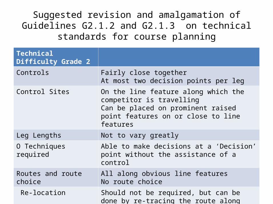
Suggested revision and amalgamation of Guidelines G2.1.2 and G2.1.3 on technical standards for course planning
Technical Difficulty Grade 2
Controls Fairly close togetherAt most two decision points per leg
Control Sites On the line feature along which the competitor is travelling Can be placed on prominent raised point features on or close to line features
Leg Lengths Not to vary greatly
O Techniques required Able to make decisions at a ‘Decision’ point without the assistance of a control
Routes and route choice All along obvious line features No route choice
Re-location Should not be required, but can be done by re-tracing the route along line features
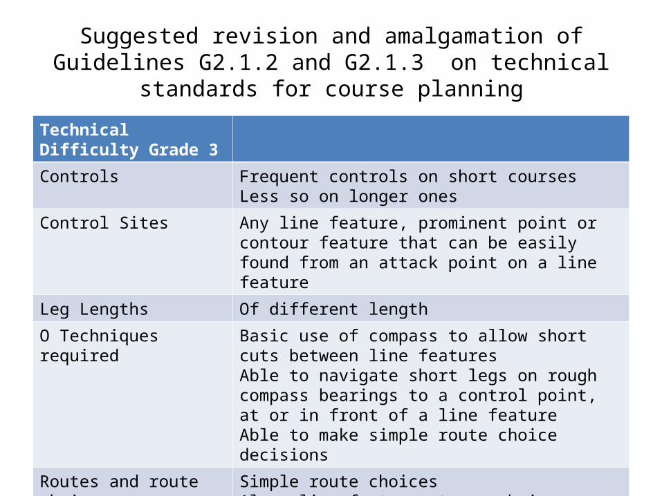
Suggested revision and amalgamation of Guidelines G2.1.2 and G2.1.3 on technical standards for course planning
Technical Difficulty Grade 3
Controls Frequent controls on short coursesLess so on longer ones
Control Sites Any line feature, prominent point or contour feature that can be easily found from an attack point on a line feature
Leg Lengths Of different length
O Techniques required Basic use of compass to allow short cuts between line featuresAble to navigate short legs on rough compass bearings to a control point, at or in front of a line featureAble to make simple route choice decisions
Routes and route choice Simple route choicesAlong line features to an obvious attack point
Re-location Should be a collecting feature close behind all controls that are not on a line feature

Suggested revision and amalgamation of Guidelines G2.1.2 and G2.1.3 on technical standards for course planning
Technical Difficulty Grade 4
Controls As few as necessary for good planning
Control Sites Any feature but should not require complex map reading
Leg Lengths Of different length
O Techniques required Able to navigate long legs on a rough compass bearing to a collecting featureAble to use an accurate compass bearing on short legsAble to navigate over short distances using simple contour features
Routes and route choice Significant route choices encouraging contouring
Re-location Collecting features behind all controlsErrors should not involve significant time loss

Suggested revision and amalgamation of Guidelines G2.1.2 and G2.1.3 on technical standards for course planning
Technical Difficulty Grade 5
Controls As few as necessary for good planning
Control Sites Any feature particularly those demanding careful map readingNo hidden or isolated controls
Leg Lengths Of different lengthsLong route choice followed by short intricate legs
O Techniques required Able to navigate for long distances using only major contour featuresAble to read and interpret complex contoursAble to recognise indistinct featuresAble to fully concentrate over all of the course
Routes and route choice Significant route choices
Re-location Control sites far from obvious relocating featureErrors should be costly in time
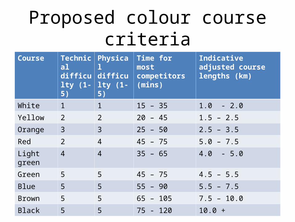
Proposed colour course criteriaCourse Technical
difficulty (1-5)
Physical difficulty (1-5)
Time for most competitors (mins)
Indicative adjusted course lengths (km)
White 1 1 15 – 35 1.0 - 2.0
Yellow 2 2 20 – 45 1.5 – 2.5
Orange 3 3 25 – 50 2.5 – 3.5
Red 2 4 45 – 75 5.0 – 7.5
Light green 4 4 35 – 65 4.0 - 5.0
Green 5 5 45 – 75 4.5 – 5.5
Blue 5 5 55 – 90 5.5 – 7.5
Brown 5 5 65 – 105 7.5 – 10.0
Black 5 5 75 - 120 10.0 +
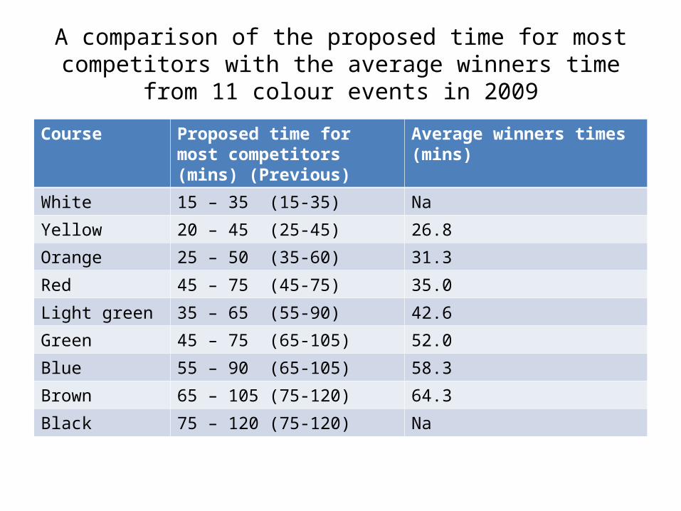
A comparison of the proposed time for most competitors with the average winners time from 11 colour events in 2009
Course Proposed time for most competitors (mins) (Previous)
Average winners times (mins)
White 15 – 35 (15-35) Na
Yellow 20 – 45 (25-45) 26.8
Orange 25 – 50 (35-60) 31.3
Red 45 – 75 (45-75) 35.0
Light green 35 – 65 (55-90) 42.6
Green 45 – 75 (65-105) 52.0
Blue 55 – 90 (65-105) 58.3
Brown 65 – 105 (75-120) 64.3
Black 75 – 120 (75-120) Na

Percentage of competitors with times within the recommended time range for each class from eleven colour events in 2009
Event Average%
Clarabeg 63.5
Bull Island 47.8
Kilmore Quay 54.4
Mall Hill 65.4
Clarabeg 71.4
Tramore 73.3
Marlogue 68.0
Scarr 62.7
Banna 52.0
Mondeligo 63.3
Glendassan 56.9
AVERAGE 61.7
Course Average%
Yellow 57.1
Orange 57.3
Red 70.0
Light green 43.2
Green 59.4
Blue 80.1
Brown 66.1
Average 61.7