introduction swale
TRANSCRIPT
5/14/2018 Introduction Swale - slidepdf.com
http://slidepdf.com/reader/full/introduction-swale 1/9
Introduction Swale
What is a Swale?
A “swale” is a relatively broad land drainage depression along which storm-water flows.
Its primary purpose is to hold back flows by decreasing the water velocity using grass or otherforms of vegetation to slow down the velocity. This in turn, helps to reduce the flood peaks in thereceiving waterways.
It has a secondary function to improve water quality by reducing contaminant (pollutant)loadings. A decreased flow velocity facilitates the settling of sediments and the vegetative growthtraps additional suspended sediment.
Swales are most effective as a storm-water treatment device when the water velocity is slow andthe swale is densely grassed or vegetated.
If a swale requires mowing or cut down, the Council will complete this when the grass gets to200mm in length as per the Resource Consent guidelines.
Guidelines for construction of swales for water quality improvement and flow attenuation of lightly contaminated runoff from poultry farms
What is a swale?
Swales are linear depressions formed in the ground to receive runoff and slowly move water to adischarge point. Unlike ditches, they are normally dry out with wet weather and are grassed.Side and longitudinal slopes are gentle. The slow movements of water along the swale, aided by grass and check dams, encourage deposition of solids washed off the hard standing, and help to
remove nutrients such as phosphorus. Standard Farming Installation Rule 2.3.3.12 allows lightly contaminated drainage, e.g. from yard areas or roofs to be treated by means of swales orconstructed wetlands.
Swales dug into even the gentlest of slopes will fill with water after every good rain and
allow the moisture to percolate deep into the soil over a day or more. This charges thesubsoil over several years allowing the trees planted into the mound to thrive even during
the driest of times
What are the benefits of using swales?
• Improves water quality
• Cheaper to construct than piped systems
• Can be incorporated into the landscape
• Low maintenance
• Visible operation
1
5/14/2018 Introduction Swale - slidepdf.com
http://slidepdf.com/reader/full/introduction-swale 2/9
What makes a good swale?
• The longer the swale the better. A long swale allows plenty of time forsettlement of solids contained in the runoff. Swales of more than 70m in lengthgive good, consistent performance.
• No sharp corners. Swales should have gentle curves.
• Shallow gradients. A swale which curves too and fro with a shallow gradient is better than a swale which is built directly down slope.
• Shallow swales with no permanent water have better chance of establishing agrass sward.
Where should the swale be located?
This will depend on the layout of the site and the amount of space available, but the swale wouldusually run either parallel with or at 90° to the houses, with the hard-standing draining towardsthe swale. To comply with Standard Farming Rule 2.3.3.2 outflow points into the swale should
be capable of being stopped with a drain blocker so heavily contaminated runoff, such as may
occur when cleaning out, can be diverted to waste effluent tanks. Larger farms may need morethan one swale; a second swale could possibly be located between sheds. Roof water can bedirected to the swale via surface drains or via smaller swales.
What is a check dam?
Check dams are small dams constructed across a swale. The check dam is made from graded broken stone. Runoff will pond behind the dam allowing sediment to settle out. As the check dam is made of stone, it will allow the ponded water to discharge slowly towards the outlet. Thisimproves the efficiency of the swale.
What is the easiest method for designing a swale?
To improve water quality, the “first flush” of dirty water, washed off the hard standing, istrapped behind check dams built across the swale. This first flush is known as the treatment
volume. To calculate the number of check dams needed to retain the treatment volume, follow the eight steps listed below.
Action Step 1. Measure the roof area and area of hard standing, A (m2) 5450m2Step 2. Establish the length available for the swale based on sitelayout, L (m)
120m
Step 3. Measure the land gradient for the swale (%) 2%
Step 4. Calculate the treatment volume Vt (m3) = A × 0.012 5,450 × 0.012 = 65.4m3
Step 5. Calculate the number of check damsi) From table A, look up the distance between check dams for thegradient in Step 3. Initially assume the narrowest swale floor width of
swale floor with = 1mgradient = 2%distance = 25m
2
5/14/2018 Introduction Swale - slidepdf.com
http://slidepdf.com/reader/full/introduction-swale 3/9
1 m.ii) Divide swale length L in Step 2. by the distance between check dams to calculate the number of check dams.
120 ÷ 25 = 5 check dams
Step 6. Will the number of check dams store the treatment volume?i) From table B. look up the volume held by each check dam
ii) Multiply the volume per check dam by the number of check dams.
Swale floor width = 1mGradient = 2%
Volume per check dam = 10m310 × 5 = 50.0m3
Step 7. If the volume stored by the check dams is less than thetreatment volume increas e the swale floor width
Swale floor width = 1.5mGradient = 2%
Volume per check dam = 13.1m3 Volume of storage = 65.5m3
Step 8. When the volume of storage behind the check dams is greaterthan or equal to the treatment volume proceed with swaleconstruction.
Treatment volume Vt = 65.4m3Check damstorage volume = 65.5m3
Note 1: A value of 0.012 - 0.015 represents the quantity of the ‘first flush’ of runoff that willcontain lightly contaminated washings. The values are obtained from “Sustainable UrbanDrainage Systems: Design Manual for Scotland and Northern Ireland”.
Table A Distance between check dams
Swale Gradient (%) 1 2 3 4 5Distance between check dams (m) 50 25 16.5 12.5 10
Table B Volume per check dam
Swale Gradient (%) 1 2 3 4 5
Floor width (m) 1.0 20.0 10.0 6.7 5.0 4.01.5 26.3 13.1 8.8 6.6 5.32.0 32.5 16.3 10.8 8.1 6.5
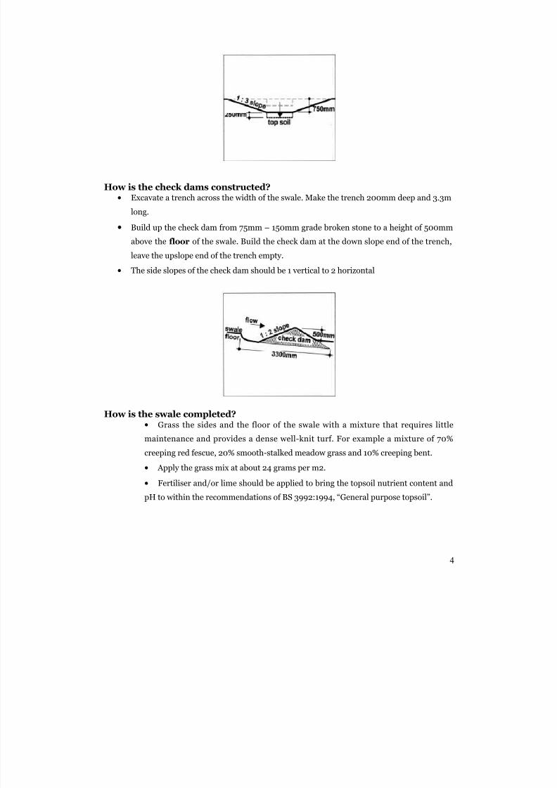
How is the Swale constructed?
• Excavate the swale to a depth of 750mm.
• Store the top soil separately.
• Make the width of the swale floor equal to the width calculated in the 8
steps shown above.• Make the side slopes 1 vertical to 3 horizontal or more gentle if there isenough room.
• Excavate the floor of the swale for a further 150 - 250mm depth andreplace the excavated material with the top soil.
3
5/14/2018 Introduction Swale - slidepdf.com
http://slidepdf.com/reader/full/introduction-swale 4/9
How is the check dams constructed?• Excavate a trench across the width of the swale. Make the trench 200mm deep and 3.3m
long.
• Build up the check dam from 75mm – 150mm grade broken stone to a height of 500mm
above the floor of the swale. Build the check dam at the down slope end of the trench,
leave the upslope end of the trench empty.
• The side slopes of the check dam should be 1 vertical to 2 horizontal
How is the swale completed?• Grass the sides and the floor of the swale with a mixture that requires little
maintenance and provides a dense well-knit turf. For example a mixture of 70%
creeping red fescue, 20% smooth-stalked meadow grass and 10% creeping bent.• Apply the grass mix at about 24 grams per m2.
• Fertiliser and/or lime should be applied to bring the topsoil nutrient content and
pH to within the recommendations of BS 3992:1994, “General purpose topsoil”.
4
5/14/2018 Introduction Swale - slidepdf.com
http://slidepdf.com/reader/full/introduction-swale 5/9
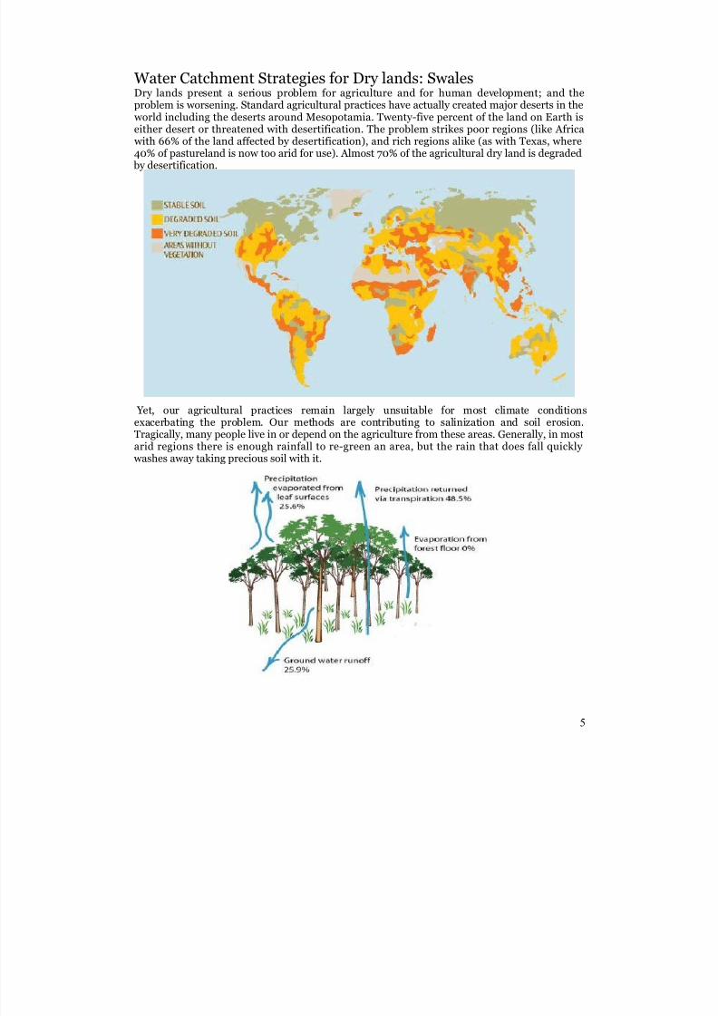
Water Catchment Strategies for Dry lands: SwalesDry lands present a serious problem for agriculture and for human development; and theproblem is worsening. Standard agricultural practices have actually created major deserts in the
world including the deserts around Mesopotamia. Twenty-five percent of the land on Earth iseither desert or threatened with desertification. The problem strikes poor regions (like Africa
with 66% of the land affected by desertification), and rich regions alike (as with Texas, where40% of pastureland is now too arid for use). Almost 70% of the agricultural dry land is degraded by desertification.
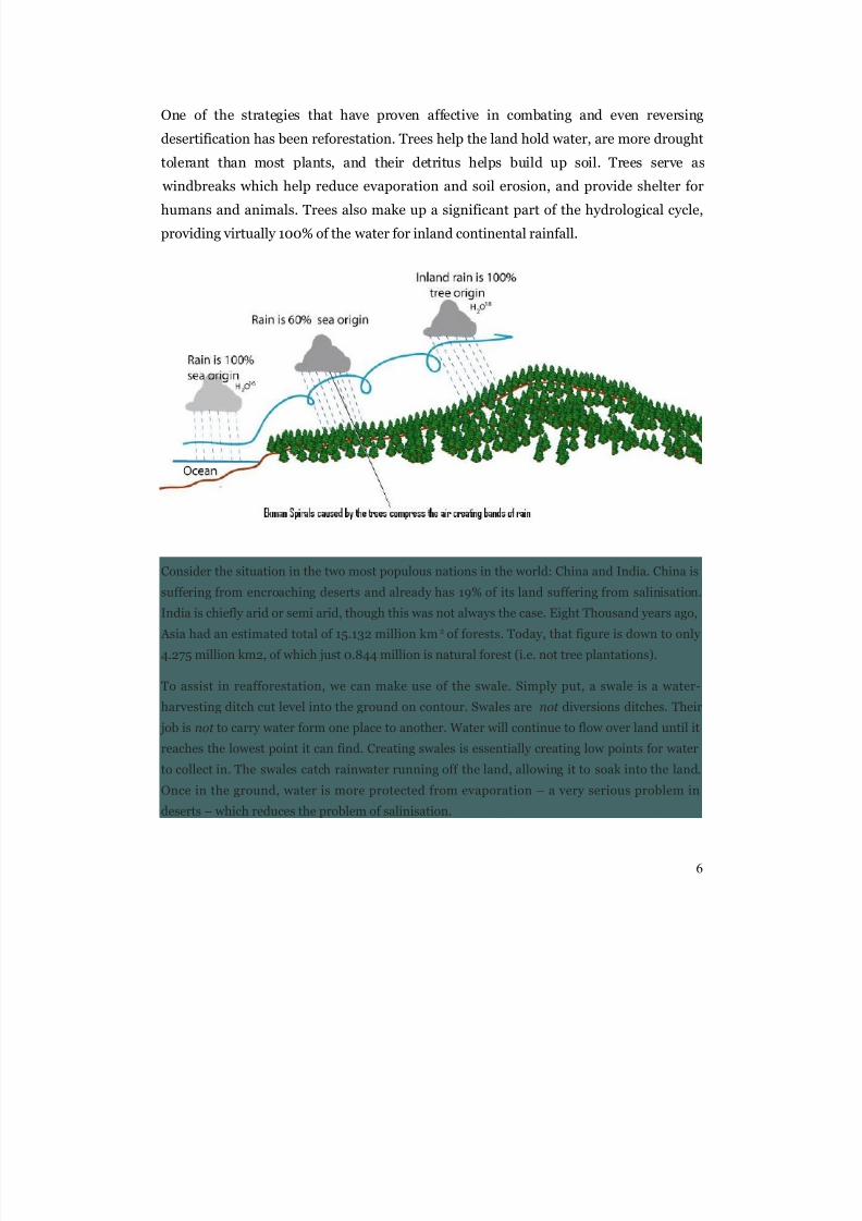
Yet, our agricultural practices remain largely unsuitable for most climate conditionsexacerbating the problem. Our methods are contributing to salinization and soil erosion.Tragically, many people live in or depend on the agriculture from these areas. Generally, in mostarid regions there is enough rainfall to re-green an area, but the rain that does fall quickly
washes away taking precious soil with it.
5
5/14/2018 Introduction Swale - slidepdf.com
http://slidepdf.com/reader/full/introduction-swale 6/9
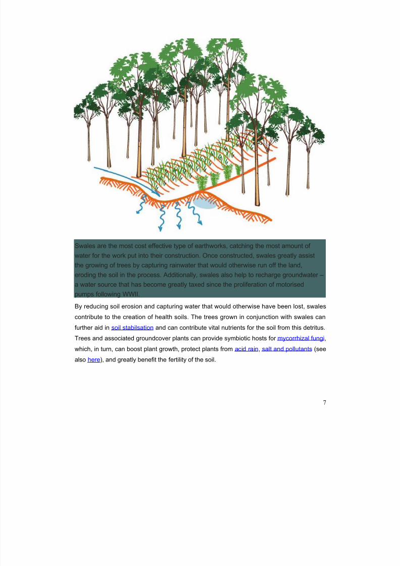
One of the strategies that have proven affective in combating and even reversing
desertification has been reforestation. Trees help the land hold water, are more drought
tolerant than most plants, and their detritus helps build up soil. Trees serve as
windbreaks which help reduce evaporation and soil erosion, and provide shelter for
humans and animals. Trees also make up a significant part of the hydrological cycle,
providing virtually 100% of the water for inland continental rainfall.
Consider the situation in the two most populous nations in the world: China and India. China is
suffering from encroaching deserts and already has 19% of its land suffering from salinisation.
India is chiefly arid or semi arid, though this was not always the case. Eight Thousand years ago,
Asia had an estimated total of 15.132 million km2 of forests. Today, that figure is down to only
4.275 million km2, of which just 0.844 million is natural forest (i.e. not tree plantations).
To assist in reafforestation, we can make use of the swale. Simply put, a swale is a water-
harvesting ditch cut level into the ground on contour. Swales are not diversions ditches. Their
job is not to carry water form one place to another. Water will continue to flow over land until it
reaches the lowest point it can find. Creating swales is essentially creating low points for water
to collect in. The swales catch rainwater running off the land, allowing it to soak into the land.
Once in the ground, water is more protected from evaporation – a very serious problem in
deserts – which reduces the problem of salinisation.
6
5/14/2018 Introduction Swale - slidepdf.com
http://slidepdf.com/reader/full/introduction-swale 7/9
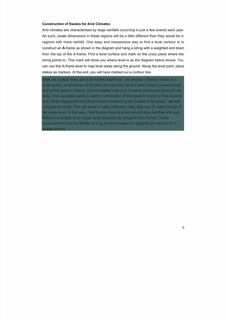
Swales are the most cost effective type of earthworks, catching the most amount of
water for the work put into their construction. Once constructed, swales greatly assist
the growing of trees by capturing rainwater that would otherwise run off the land,
eroding the soil in the process. Additionally, swales also help to recharge groundwater –
a water source that has become greatly taxed since the proliferation of motorised
pumps following WWII.
By reducing soil erosion and capturing water that would otherwise have been lost, swales
contribute to the creation of health soils. The trees grown in conjunction with swales can
further aid in soil stabilsation and can contribute vital nutrients for the soil from this detritus.
Trees and associated groundcover plants can provide symbiotic hosts for mycorrhizal fungi,
which, in turn, can boost plant growth, protect plants from acid rain, salt and pollutants (see
also here), and greatly benefit the fertility of the soil.
7
5/14/2018 Introduction Swale - slidepdf.com
http://slidepdf.com/reader/full/introduction-swale 8/9
Construction of Swales for Arid Climates
Arid climates are characterised by large rainfalls occurring in just a few events each year.
As such, swale dimensions in these regions will be a little different than they would be in
regions with more rainfall. One easy and inexpensive way to find a level contour is to
construct an A-frame as shown in the diagram and hang a string with a weighted end down
from the top of the A-frame. Find a level surface and mark on the cross piece where the
string points to. This mark will show you where level is as the diagram below shows. You
can use this A-frame level to map level areas along the ground. Along the level point, place
stakes as markers. At the end, you will have marked out a contour line.
Mark out contour lines about 20 metres apart from one another. (Twenty metres is a
rough guide, as the shape of the land will make the contour lines closer in some places
and further apart in others). Dig the swales to be 2 to 3 metres across and about 50 cmdeep. The excavated earth is used in construction of the swale’s mound on the downhill
side. When digging the trench and when constructing the mound of the swale, do not
compact the earth. This will assist in water infiltration. Also take care to make the top of
the swale level. In this way, it will be less likely to erode should they overflow with rain.
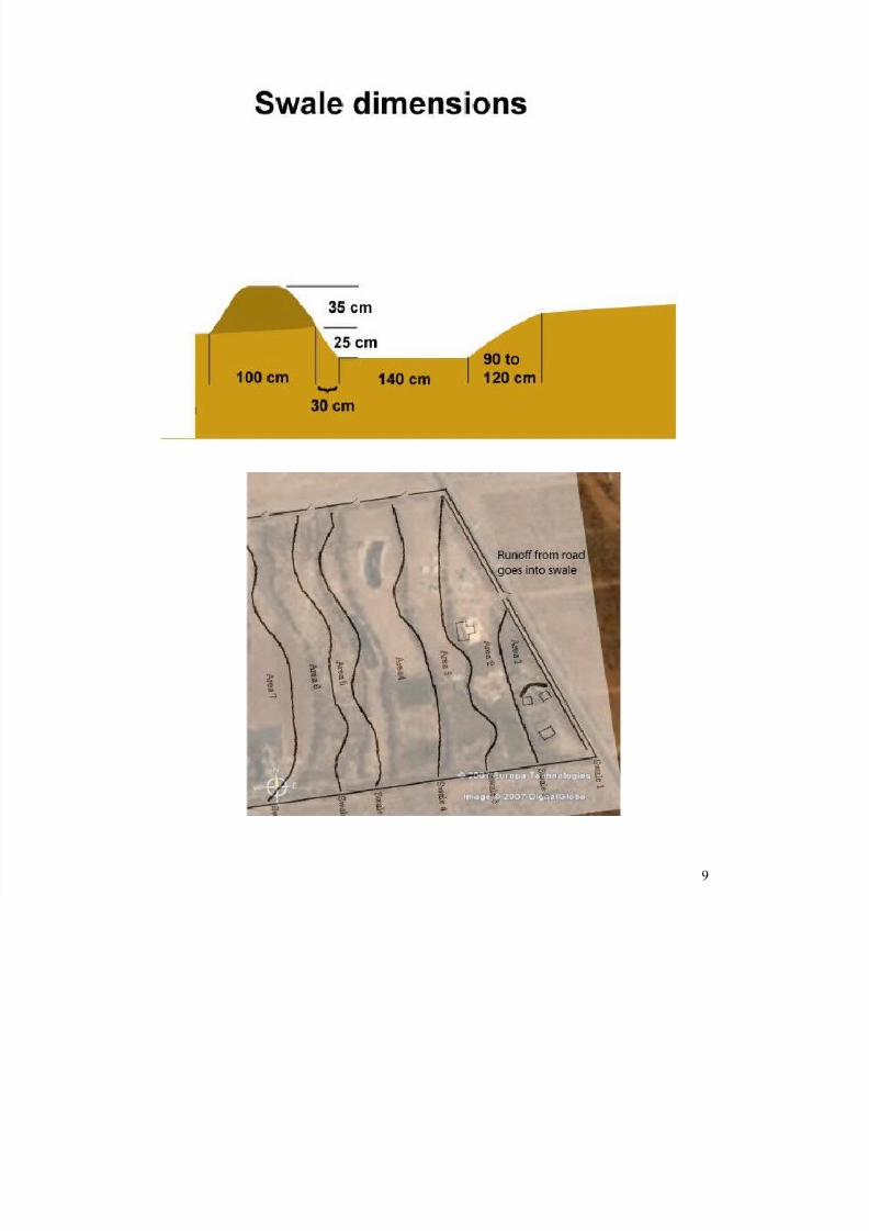
Below is a sample of an actual swale designed by designer Dan Palmer. These
measurements can be flexible as long as these swales for drylands are about 2 to 3
metres across.
8
5/14/2018 Introduction Swale - slidepdf.com
http://slidepdf.com/reader/full/introduction-swale 9/9
9