international specification for sprint orienteering maps...
TRANSCRIPT
IOF Map Commission
2006
International Specification forSprint Orienteering Maps
(ISSOM)
Valid from 1 January 2007
Correction of errors:
dash length corrected in the illustration (0.3 mm 3 mm)
November 2012 ymbol 70 , page 23:: s 9
→
The sprint orienteering format has been defined by the IOF as follows:Sprint orienteering is a fast, visible, easy-to-understand format, allowing orienteering to be stagedwithin areas of significant population. The sprint profile is high speed. Sprint is built on very high speedrunning in very runnable parks, streets or forests. The winning time, for both women and men, shall be12-15 minutes, preferably the lower part of the interval.
The main characteristics of the ISSOM:
ISSOM is based on the ISOM2000; but competitors and mapmakers must understand that sprint mapsare special maps.Many of the requirements in ISOM2000 will also apply to Sprint maps.The most important difference between ISOM2000 and ISSOM is that thick black lines are now onlyused for uncrossable features. To ensure fairness it has been decided that features which are mappeduncrossable (e.g. walls, fences, cliffs, water and hedges) are also forbidden to cross.
Sprint orienteering differs from the longer established forms of foot orienteering. Whilst foot orienteeringevents traditionally have been staged mainly in forested areas, sprint events can be staged in any type ofterrain. The use of parks and urban terrain in particular has important advantages: it brings the sport towhere people are, and offers opportunities for increasing public and media awareness of orienteering, inaccordance with the objectives of the Leibnitz Convention.
The expansion from classical forested terrain into parks and urban terrain presents new challenges inorienteering cartography. The current international specification for orienteering maps (ISOM 2000)contains symbols that are suitable for representing forested terrain. However, to ensure fair sprintorienteering competitions, the symbol set needs revision and extension in order to better accommodateparks and urban terrain. There are a number of reasons why the cartographic representation of terrain forsprint orienteering requires a different approach compared to that used for representation of ‘classical’forested terrain. These include:
Many more restrictions affecting route choice have to be considered in parks and urban terrains, suchas physical barriers and areas with forbidden access.The amount of significant detail in urban terrain, particularly in the centre of old towns, is often muchgreater than in a forested terrain.Not only must the new types of terrain be considered when making the sprint map specification but alsothe purpose of the map – sprint orienteering – must be taken into account.
Due to the these restrictions and constraints, principles have been settled for the InternationalSpecification for Sprint Orienteering Maps (ISSOM), which in some respects deviate significantly from
To achieve fairness, it is necessary for mapmakers and course planners to collaborate more closelythan for other disciplines.The correct mapping of reduced running speed, both to degree and extent, is extremely important forsprint orienteering because of the short winning times.In urban areas, it is not unusual to find multilevel areas. ISSOM allows for the representation of simpleunderpasses and overpasses. More complex multilevel areas which cannot be mapped clearly are notsuitable for IOF events.
The Map Commission of the International Orienteering Federation is responsible for all matters related toorienteering maps within the IOF, such as map standardisation, development, education and qualityassurance.
The ISSOM project started in 2001, as a result of the Leibnitz Convention, which introduced the sprintdiscipline into the World Orienteering Championships (WOC) programme.
Sprint orienteering introduce new mapping challenges. We have previously had park maps, but sprintevents can take place in forests, in urban areas and in mixed environments. To establish a mappingstandard for this new discipline has proven much more complicated than for traditional orienteering.
The Map Commission issued draft versions of the ISSOM in 2003 and 2004 and the opinions of theparticipants in the sprint discipline of the WOC in those years were sought. Their responses and those ofNational Federations was invaluable in producing the final version of the ISSOM in 2005.
Since the publication of the 2005 version several smaller issues have been discovered, such as textualinconsistencies and grammatical errors. We hope that most of these have been fixed in this 2006 update.A clarification has been made for symbol (529.1): Steps shall always berepresented with a 0.07 mm line. The symbol (710) has been removed. The symbol
(709) shall be used also for dangerous areas.
s / Budapest, 1 October 2006
step or edge of paved areadangerous area out-
of-bounds area
Å
H vard Tveite László Zentaiå ( hairman), ( roject leader),
MC members: Sergio Grifoni, Flemming Hjorth Jensen, Jukka Liikari, Erik E. Peckett
C PThomas Gloor
1 INTRODUCTIONFOREWORD
32
those of the ISOM 2000.Only symbols that are listed in Chapter 5 (ISSOM), may be used for Sprint Orienteering maps.
The ISSOM must therefore be treated as a specification in its own right.
Map legibility depends on the chosen map scale and a well-chosen set of symbols as well as theapplication of generalisation rules. The ideal representation would be realised if every feature could berepresented in true shape. Obviously, this is impossible, and an effort to draw each feature true to scalewould result in a map impossible to read even with the aid of a magnifying glass. Depending on the chosenmap scale, some symbols must represent features and be exaggerated in size, often far beyond the actualground limits of the feature represented. In addition, not all features are essential for the purpose of themap, or as Eduard Imhof, a famous Swiss cartographer, stated:
.
Features that are important for navigation, indicate runnability, or which shall not be crossed in sprintorienteering, have been listed in Chapter 5. Features that are not important for a competitor taking part in asprint orienteering event should not be mapped. Examples of this are waste baskets, fire hydrants, parkingmeters and individual street lights.To ensure legible maps, the ISSOM symbol set has been tried out in a number of test prints to provide awell balanced set of symbols that are clearly distinguishable in their size, line width, line type and colouring.In the end, it is the mapmaker’s task to produce precise and legible sprint orienteering maps by applyingthese specifications and generalisation rules, such as selection, simplification and exaggeration.
‘A map with few well chosen features will give a much better map than a map cluttered with manyinsignificant features’
Barriers, such as high walls, high fences and high rock faces, affect route choices and shall berepresented unambiguously. Therefore, these features shall be represented with a prominent thickblack line.Obstacles which can be crossed, such as fences and small rock faces, are represented with asignificantly thinner black line than the barrier features.Features which can be crossed very easily, such as steps and edges of paved areas, are representedwith a very thin black line.
This principle makes it impossible to use the road and track symbols of ISOM 2000 in an unmodified form.The large scale of sprint orienteering maps makes it possible for roads and vehicle tracks to berepresented in their true shape.
z
z
z
Hence, thick black lines are, in these specifications, used to represent barriers, which cannot orshall not be crossed.
To make sprint orienteering fair to all competitors, features that are represented on the map as impassable,independently of their effective passability, shall not be crossed.
This rule is essential for two reasons:It is impossible to declare an exact height when an obstacle becomes impassable. Effective passabilitydepends very much on the physical characteristics of the competitors such as body height and strength.If features represented as barriers on the map are declared as forbidden to cross, the conditions are thesame for all.
Running and navigational skills should be the success factors for competitors in a race, rather than luckwhen it comes to climbing or jumping barriers or violating public law.
Crossing of certain areas and linear features in parks and urban terrain may be forbidden by law.
Consequently, competitors who do not obey this rule, which is part of the IOF competition rules,must be disqualified.
Traffic that can influence the results cannot be allowed in a competition area for sprint orienteering, forfairness and safety reasons.
A collision between a person and a car, even at a moderate speed, can cause injury or death. Neitherdrivers nor competitors are fully aware of each other during a competition. Car traffic makes seriousaccidents possible, and this must be avoided in orienteering events.
It is not possible to represent the variable characteristics of traffic volumes that affect the route choice ofthe competitor on an orienteering map. It is therefore not possible to guarantee fair conditions for allcompetitors with traffic in the terrain. Therefore, sprint orienteering events shall be staged only wheretraffic can be kept out.
The organisers should consider the following measures:Halting of traffic (closing of roads).Restricting traffic (controlled by policemen).Construction of temporary overpasses (e.g. bridges).Separating competitors from pedestrians and spectators by the use of tape or barriers.
If such measures are necessary but not possible then the chosen area is not suitable for sprintorienteering.
Multilevel structures such as bridges, canopies, underpasses or underground buildings are common inurban areas. The cartographic representation of more than one level is in general impossible.Hence only the main ‘running’ level should be represented on the map. However, underground passages
2 PRINCIPLES
2.1 Map legibility
2.2 Barriers - Black line width is used to show passability
2.3 Barriers that are forbidden to cross
2.4 Traffic must be kept out of sprint orienteering areas
2.5 The main ‘running’ level of multilevel structures should berepresented
54
(e.g. underpasses, lighted tunnels) or overpasses (e.g. bridges), which are important for the competitorsshould be represented on the map.
The restrictions and constraints of sprint orienteering must be taken seriously by the organizers andcourse planners. In particular:
Both mapmaker and course planner should consider all possible route choices and make decisions onimpassable features and out-of-bounds areas.The course planner should not encourage unfair actions from the competitors, such as crossing barriersor areas with forbidden access. If it is unavoidable to set legs that cross or skirt areas with forbiddenaccess or impassable walls and fences, then they have to be marked in the terrain, and observersshould be present at the critical points.Control points shall not be placed under or above the main ‘running’ level.
The map scale shall be either 1:4 000 or 1:5 000. The scales 1:5 000 and 1:4 000 are suitable for the sprintformat. They allow course lengths up to 4.0 km with a handy map format. A scale of 1:5 000 is suitable formost terrains. However, the level of detail in some urban terrains, particularly in the centre of old towns withlots of essential features (e.g. stairs, narrow alleys or small passages) may be better suited to a scale of1:4 000. The size of the symbols is the same for both scales.
The contour interval value shall be either 2 m or 2.5 m for both 1:5 000 and 1:4 000. The contour is the mostimportant element in the cartographic representation of the terrain and the only one which determinesrelief forms geometrically.The brownness (percentage of brown) is the most important indicator of the slope of the ground for thecompetitor. Contour interval, contour line width and map scale should therefore be balanced in order toobtain maps with similar brownness for the same terrain using all foot orienteering map specifications. TheISSOM contour interval has been chosen to correspond with the ISOM contour interval regardingbrownness (taking into account line width and scale).
No deviations from the given dimensions within these specifications are permitted. It is however acceptedthat due to limitations in printing technology the final map symbol dimensions may vary up to +/-5%.
Dimensions in this book are given at the printed scale of 1:5 000 and 1:4 000.
3.3 Dimensions of map symbols
The map format should not exceed DINA4.
3.4 Format of the map
The 7-colour concept of ISOM2000 is also to be adopted for Sprint Orienteering maps. Thus, colourcombinations of black, brown, yellow, blue, green and grey are possible, in addition to purple overprint.
3.5 Colour Concept
All line widths and symbol dimensions must be kept strictly to their specified value. Certain minimumdimensions must also be observed. These are based on both printing technology and the need forlegibility.
MINIMUM DIMENSIONSGap between two line symbols of the same colour, in brown or black: 0.15 mm,
in blue: 0.25 mmGap between line symbols and area symbols of the same colour, in black: 0.15 mmShortest dotted line: at least two dotsShortest dashed line: at least two dashesSmallest area enclosed by a dotted line: 1.5 mm (diameter) with 5 dotsSmallest area of colourBlue, green, grey or yellow full colour: 0.5 mmBlack dot screen: 0.5 mmBlue, brown, green or yellow dot screen: 1.0 mm
All features smaller than the dimensions above must be either exaggerated or omitted, depending onwhether or not they are of significance to the competitor. When a feature is enlarged, neighbouringfeatures must be displaced so that the correct relative positions are maintained.
SCREENSVegetation, open areas, marshes, etc. are shown with dot or line screens. The following table lists thepermissible combinations of screens.
2
2
2
§
§
§
§
§
§
Other symbols (like 211, 411, 412, 413, 421, 528.1, 529) cannot be combined with other symbols.
117 Broken ground 117 Broken ground Permitted combinations210 Stony ground 210 Stony ground
309 Impassable marsh 309 Impassable marsh
401 Open land 401 Open land402 Open land with scattered trees 402 Open land with scattered trees403 Rough open land 403 Rough open land404 Rough open land with scattered trees 404 Rough open land with scattered trees406 Forest: slow running 406 Forest: slow running407 Undergrowth: slow running 407 Undergrowth: slow running
408 Forest: difficult to run 408 Forest: difficult to run409 Undergrowth: difficult to run 409 Undergrowth: difficult to run410 Vegetation: very difficult to run
310 Marsh 310 Marsh311 Indistinct marsh 311 Indistinct marsh
2.6 Collaboration between course planner and mapmaker
3 BASIC ELEMENTS
3.1 Scale
3.2 Contour interval
76
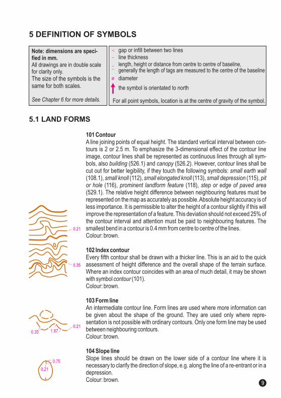
101 Contour
102 Index contour
103 Form line
104 Slope line
A line joining points of equal height. The standard vertical interval between con-tours is 2 or 2.5 m. To emphasize the 3-dimensional effect of the contour lineimage, contour lines shall be represented as continuous lines through all sym-bols, also (526.1) and (526.2). However, contour lines shall becut out for better legibility, if they touch the following symbols:(108.1), (112), (113), (115),
(116), (118),(529.1). The relative height difference between neighbouring features must berepresented on the map as accurately as possible.Absolute height accuracy is ofless importance. It is permissible to alter the height of a contour slightly if this willimprove the representation of a feature. This deviation should not exceed 25% ofthe contour interval and attention must be paid to neighbouring features. Thesmallest bend in a contour is 0.4 mm from centre to centre of the lines.Colour: brown.
Every fifth contour shall be drawn with a thicker line. This is an aid to the quickassessment of height difference and the overall shape of the terrain surface.Where an index contour coincides with an area of much detail, it may be shownwith symbol (101).Colour: brown.
An intermediate contour line. Form lines are used where more information canbe given about the shape of the ground. They are used only where repre-sentation is not possible with ordinary contours. Only one form line may be usedbetween neighbouring contours.Colour: brown.
Slope lines should be drawn on the lower side of a contour line where it isnecessary to clarify the direction of slope, e.g. along the line of a re-entrant or in adepression.Colour: brown.
building canopysmall earth wall
small knoll small elongated knoll small depression pitor hole prominent landform feature step or edge of paved area
contour
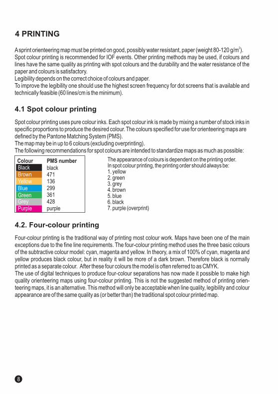
Spot colour printing uses pure colour inks. Each spot colour ink is made by mixing a number of stock inks inspecific proportions to produce the desired colour. The colours specified for use for orienteering maps aredefined by the Pantone Matching System (PMS).The map may be in up to 6 colours (excluding overprinting).The following recommendations for spot colours are intended to standardize maps as much as possible:
Asprint orienteering map must be printed on good, possibly water resistant, paper (weight 80-120 g/m ).Spot colour printing is recommended for IOF events. Other printing methods may be used, if colours andlines have the same quality as printing with spot colours and the durability and the water resistance of thepaper and colours is satisfactory.Legibility depends on the correct choice of colours and paper.To improve the legibility one should use the highest screen frequency for dot screens that is available andtechnically feasible (60 lines/cm is the minimum).
2
The appearance of colours is dependent on the printing order.In spot colour printing, the printing order should always be:1. yellow2. green3. grey4. brown5. blue6. black7. purple (overprint)
Four-colour printing is the traditional way of printing most colour work. Maps have been one of the mainexceptions due to the fine line requirements. The four-colour printing method uses the three basic coloursof the subtractive colour model: cyan, magenta and yellow. In theory, a mix of 100% of cyan, magenta andyellow produces black colour, but in reality it will be more of a dark brown. Therefore black is normallyprinted as a separate colour. After these four colours the model is often referred to as CMYK.The use of digital techniques to produce four-colour separations has now made it possible to make highquality orienteering maps using four-colour printing. This is not the suggested method of printing orien-teering maps, it is an alternative. This method will only be acceptable when line quality, legibility and colourappearance are of the same quality as (or better than) the traditional spot colour printed map.
Colour PMS numberblack471136299361428purple
BlackBrownYellowBlueGreenGreyPurple
Note: dimensions are speci-fied in mm.All drawings are in double scalefor clarity only.The size of the symbols is thesame for both scales.
See Chapter 6 for more details.
gap or infill between two linesline thicknesslength, height or distance from centre to centre of baseline,generally the length of tags are measured to the centre of the baselinediameter
the symbol is orientated to north
For all point symbols, location is at the centre of gravity of the symbol.
5.1 LAND FORMS
5 DEFINITION OF SYMBOLS
4.2. Four-colour printing
4.1 Spot colour printing
4 PRINTING
0.21
0.211.870.35
0.35
0.21
0.75
8 9
101 Contour
102 Index contour
103 Form line
104 Slope line
A line joining points of equal height. The standard vertical interval between con-tours is 2 or 2.5 m. To emphasize the 3-dimensional effect of the contour lineimage, contour lines shall be represented as continuous lines through all sym-bols, also (526.1) and (526.2). However, contour lines shall becut out for better legibility, if they touch the following symbols:(108.1), (112), (113), (115),
(116), (118),(529.1). The relative height difference between neighbouring features must berepresented on the map as accurately as possible.Absolute height accuracy is ofless importance. It is permissible to alter the height of a contour slightly if this willimprove the representation of a feature. This deviation should not exceed 25% ofthe contour interval and attention must be paid to neighbouring features. Thesmallest bend in a contour is 0.4 mm from centre to centre of the lines.Colour: brown.
Every fifth contour shall be drawn with a thicker line. This is an aid to the quickassessment of height difference and the overall shape of the terrain surface.Where an index contour coincides with an area of much detail, it may be shownwith symbol (101).Colour: brown.
An intermediate contour line. Form lines are used where more information canbe given about the shape of the ground. They are used only where repre-sentation is not possible with ordinary contours. Only one form line may be usedbetween neighbouring contours.Colour: brown.
Slope lines should be drawn on the lower side of a contour line where it isnecessary to clarify the direction of slope, e.g. along the line of a re-entrant or in adepression.Colour: brown.
building canopysmall earth wall
small knoll small elongated knoll small depression pitor hole prominent landform feature step or edge of paved area
contour
Spot colour printing uses pure colour inks. Each spot colour ink is made by mixing a number of stock inks inspecific proportions to produce the desired colour. The colours specified for use for orienteering maps aredefined by the Pantone Matching System (PMS).The map may be in up to 6 colours (excluding overprinting).The following recommendations for spot colours are intended to standardize maps as much as possible:
Asprint orienteering map must be printed on good, possibly water resistant, paper (weight 80-120 g/m ).Spot colour printing is recommended for IOF events. Other printing methods may be used, if colours andlines have the same quality as printing with spot colours and the durability and the water resistance of thepaper and colours is satisfactory.Legibility depends on the correct choice of colours and paper.To improve the legibility one should use the highest screen frequency for dot screens that is available andtechnically feasible (60 lines/cm is the minimum).
2
The appearance of colours is dependent on the printing order.In spot colour printing, the printing order should always be:1. yellow2. green3. grey4. brown5. blue6. black7. purple (overprint)
Four-colour printing is the traditional way of printing most colour work. Maps have been one of the mainexceptions due to the fine line requirements. The four-colour printing method uses the three basic coloursof the subtractive colour model: cyan, magenta and yellow. In theory, a mix of 100% of cyan, magenta andyellow produces black colour, but in reality it will be more of a dark brown. Therefore black is normallyprinted as a separate colour. After these four colours the model is often referred to as CMYK.The use of digital techniques to produce four-colour separations has now made it possible to make highquality orienteering maps using four-colour printing. This is not the suggested method of printing orien-teering maps, it is an alternative. This method will only be acceptable when line quality, legibility and colourappearance are of the same quality as (or better than) the traditional spot colour printed map.
Colour PMS numberblack471136299361428purple
BlackBrownYellowBlueGreenGreyPurple
Note: dimensions are speci-fied in mm.All drawings are in double scalefor clarity only.The size of the symbols is thesame for both scales.
See Chapter 6 for more details.
gap or infill between two linesline thicknesslength, height or distance from centre to centre of baseline,generally the length of tags are measured to the centre of the baselinediameter
the symbol is orientated to north
For all point symbols, location is at the centre of gravity of the symbol.
5.1 LAND FORMS
5 DEFINITION OF SYMBOLS
4.2. Four-colour printing
4.1 Spot colour printing
4 PRINTING
0.21
0.211.870.35
0.35
0.21
0.75
8 9
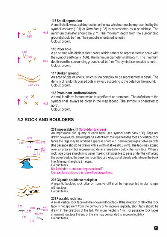
201 Impassable cliff
202 Gigantic boulder or rock pillar
203 Passable rock face
An impassable cliff, quarry or earth bank (see symbol 106). Tags aredrawn downwards, showing its full extent from the top line to the foot. For vertical rockfaces the tags may be omitted if space is short, e.g. narrow passages between cliffs(the passage should be drawn with a width of at least 0.3 mm). The tags may extendover an area symbol representing detail immediately below the rock face. When arock face drops straight into water making it impossible to pass under the cliff alongthe water's edge, the bank line is omitted or the tags shall clearly extend over the bankline. Minimum height is 2 meters.Colour: black.
A gigantic boulder, rock pillar or massive cliff be represented inwithout tags.Colour: black.
A small vertical rock face may be shown without tags. If the direction of fall of the rockface is not apparent from the contours or to improve legibility, short tags should bedrawn in the direction of the fall. Minimum height is 1 m. For passable rock facesshown without tags the end of the line may be rounded to improve legibility.Colour: black.
earth bank
shall plan shape
(forbidden to cross)
It is forbidden to cross an impassable cliff!Competitors violating this rule will be disqualified.
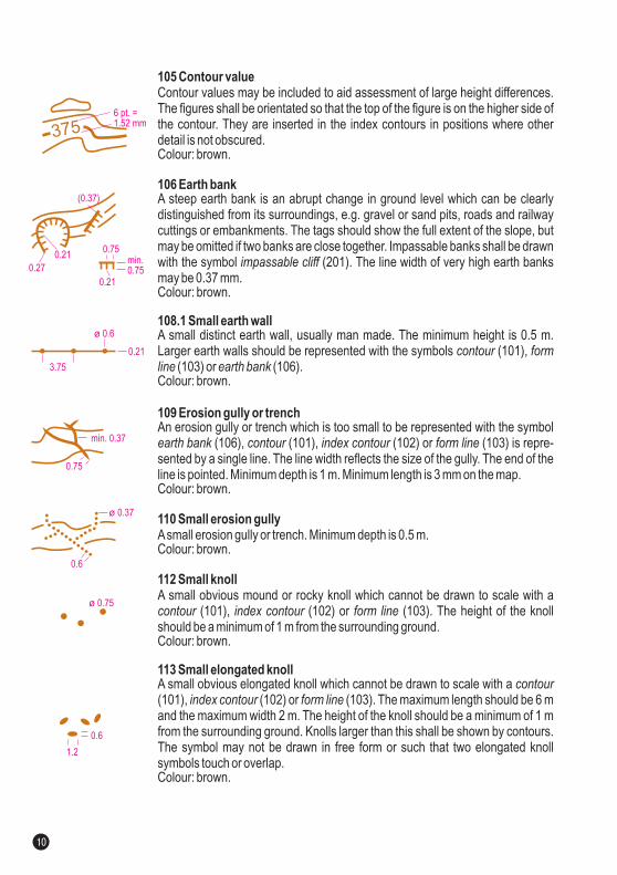
115 Small depression
116 Pit or hole
117 Broken ground
Asmall shallow natural depression or hollow which cannot be represented by thesymbol (101) or (103) is represented by a semicircle. Theminimum diameter should be 2 m. The minimum depth from the surroundingground should be 1 m. The sColour: brown.
A pit or hole with distinct steep sides which cannot be represented to scale withthe symbol (106). The minimum diameter shall be 2 m. The minimumdepth from the surrounding ground shall be 1 m.Colour: brown.
An area of pits or knolls, which is too complex to be represented in detail. Thedensity of randomly placed dots may vary according to the detail on the ground.Colour: brown.
contour form line
earth bank
ymbol is orientated to north.
Colour: brown.
The symbol is orientated to north.
118 Prominent landform featureA small landform feature which is significant or prominent. The definition of thesymbol shall always be given in the map legend. The symbol is orientated tonorth.
105 Contour value
106 Earth bank
108.1 Small earth wall
109 Erosion gully or trench
110 Small erosion gully
112 Small knoll
113 Small elongated knoll
Contour values may be included to aid assessment of large height differences.The figures shall be orientated so that the top of the figure is on the higher side ofthe contour. They are inserted in the index contours in positions where otherdetail is not obscured.Colour: brown.
A steep earth bank is an abrupt change in ground level which can be clearlydistinguished from its surroundings, e.g. gravel or sand pits, roads and railwaycuttings or embankments. The tags should show the full extent of the slope, butmay be omitted if two banks are close together. Impassable banks shall be drawnwith the symbol (201).
Colour: brown.
A small distinct earth wall, usually man made. The minimum height is 0.5 m.Larger earth walls should be represented with the symbols (101),
(103) or (106).Colour: brown.
An erosion gully or trench which is too small to be represented with the symbol(106), (101), (102) or (103) is repre-
sented by a single line. The line width reflects the size of the gully. The end of theline is pointed. Minimum depth is 1 m. Minimum length is 3 mm on the map.Colour: brown.
Asmall erosion gully or trench. Minimum depth is 0.5 m.Colour: brown.
A small obvious mound or rocky knoll which cannot be drawn to scale with a. The height of the knoll
should be a minimum of 1 m from the surrounding ground.Colour: brown.
A small obvious elongated knoll which cannot be drawn to scale with a. The maximum length should be 6 m
and the maximum width 2 m. The height of the knoll should be a minimum of 1 mfrom the surrounding ground. Knolls larger than this shall be shown by contours.The symbol may not be drawn in free form or such that two elongated knollsymbols touch or overlap.Colour: brown.
impassable cliff
contour formline earth bank
earth bank contour index contour form line
The line width of very high earth banksmay be 0.37 mm.
(101), (102) or (103)
(101), (102) or (103)
contour index contour form line
contourindex contour form line
5.2 ROCK AND BOULDERS
min.0.75
min. 0.750.50
min. 0.9
0.18
0.30
min. 0.90.75
0.75
0.18
0.75
0.30
ø 0.2 - 0.3
0.95
0.25
0. 52
1.2
0.25
0.82
1.25
ø 0.37
ø 0.75
min. 0.37
0.6
1.2
0.6
0.21
3.75
ø 0.6
0.75
0.75
0.21
0.27
0.21
(0.37)
3756 pt. =1.52 mm
min.0.75
min.0.75
10 11
201 Impassable cliff
202 Gigantic boulder or rock pillar
203 Passable rock face
An impassable cliff, quarry or earth bank (see symbol 106). Tags aredrawn downwards, showing its full extent from the top line to the foot. For vertical rockfaces the tags may be omitted if space is short, e.g. narrow passages between cliffs(the passage should be drawn with a width of at least 0.3 mm). The tags may extendover an area symbol representing detail immediately below the rock face. When arock face drops straight into water making it impossible to pass under the cliff alongthe water's edge, the bank line is omitted or the tags shall clearly extend over the bankline. Minimum height is 2 meters.Colour: black.
A gigantic boulder, rock pillar or massive cliff be represented inwithout tags.Colour: black.
A small vertical rock face may be shown without tags. If the direction of fall of the rockface is not apparent from the contours or to improve legibility, short tags should bedrawn in the direction of the fall. Minimum height is 1 m. For passable rock facesshown without tags the end of the line may be rounded to improve legibility.Colour: black.
earth bank
shall plan shape
(forbidden to cross)
It is forbidden to cross an impassable cliff!Competitors violating this rule will be disqualified.
115 Small depression
116 Pit or hole
117 Broken ground
Asmall shallow natural depression or hollow which cannot be represented by thesymbol (101) or (103) is represented by a semicircle. Theminimum diameter should be 2 m. The minimum depth from the surroundingground should be 1 m. The sColour: brown.
A pit or hole with distinct steep sides which cannot be represented to scale withthe symbol (106). The minimum diameter shall be 2 m. The minimumdepth from the surrounding ground shall be 1 m.Colour: brown.
An area of pits or knolls, which is too complex to be represented in detail. Thedensity of randomly placed dots may vary according to the detail on the ground.Colour: brown.
contour form line
earth bank
ymbol is orientated to north.
Colour: brown.
The symbol is orientated to north.
118 Prominent landform featureA small landform feature which is significant or prominent. The definition of thesymbol shall always be given in the map legend. The symbol is orientated tonorth.
105 Contour value
106 Earth bank
108.1 Small earth wall
109 Erosion gully or trench
110 Small erosion gully
112 Small knoll
113 Small elongated knoll
Contour values may be included to aid assessment of large height differences.The figures shall be orientated so that the top of the figure is on the higher side ofthe contour. They are inserted in the index contours in positions where otherdetail is not obscured.Colour: brown.
A steep earth bank is an abrupt change in ground level which can be clearlydistinguished from its surroundings, e.g. gravel or sand pits, roads and railwaycuttings or embankments. The tags should show the full extent of the slope, butmay be omitted if two banks are close together. Impassable banks shall be drawnwith the symbol (201).
Colour: brown.
A small distinct earth wall, usually man made. The minimum height is 0.5 m.Larger earth walls should be represented with the symbols (101),
(103) or (106).Colour: brown.
An erosion gully or trench which is too small to be represented with the symbol(106), (101), (102) or (103) is repre-
sented by a single line. The line width reflects the size of the gully. The end of theline is pointed. Minimum depth is 1 m. Minimum length is 3 mm on the map.Colour: brown.
Asmall erosion gully or trench. Minimum depth is 0.5 m.Colour: brown.
A small obvious mound or rocky knoll which cannot be drawn to scale with a. The height of the knoll
should be a minimum of 1 m from the surrounding ground.Colour: brown.
A small obvious elongated knoll which cannot be drawn to scale with a. The maximum length should be 6 m
and the maximum width 2 m. The height of the knoll should be a minimum of 1 mfrom the surrounding ground. Knolls larger than this shall be shown by contours.The symbol may not be drawn in free form or such that two elongated knollsymbols touch or overlap.Colour: brown.
impassable cliff
contour formline earth bank
earth bank contour index contour form line
The line width of very high earth banksmay be 0.37 mm.
(101), (102) or (103)
(101), (102) or (103)
contour index contour form line
contourindex contour form line
5.2 ROCK AND BOULDERS
min.0.75
min. 0.750.50
min. 0.9
0.18
0.30
min. 0.90.75
0.75
0.18
0.75
0.30
ø 0.2 - 0.3
0.95
0.25
0. 52
1.2
0.25
0.82
1.25
ø 0.37
ø 0.75
min. 0.37
0.6
1.2
0.6
0.21
3.75
ø 0.6
0.75
0.75
0.21
0.27
0.21
(0.37)
3756 pt. =1.52 mm
min.0.75
min.0.75
10 11
303 Waterhole
306 Passable small watercourse
308 Narrow marsh
A water-filled pit or an area of water which is too small to be shown to scale. Thesymbol is orientated to north.Colour: blue.
The minimum dimension is 1 mm .
Acrossable watercourse less than 2 m wide.Colour: blue.
A marsh or trickle of water which is too narrow to be shown with symbol(310).Colour: blue.
304.1 Impassable body of water
305.1 Passable body of water
307 Minor watercourse
309 Impassable marsh
An area of deep water such as a lake, pond, river or fountain which mayconstitute a danger to the competitor or has forbidden access. The dark bluecolour and the bordering black line indicates that the feature cannot or shall notbe crossed.Colour: blue 100% or 75% (min. 60 lines/cm), black.
An area of shallow water such as a pond, river or fountain that can be crossed.The body of water shall be less than 0.5 m deep and runnable. If the body of wateris not runnable it shall be represented with the symbol(304.1). If no other line symbol touches the border of the passable body of water,the border shall be represented with a blue line.
A natural or man-made minor watercourse which may contain water only inter-mittently.Colour: blue.
Amarsh which is impassable or which may constitute a danger to the competitor.The feature cannot or shall not be crossed.Colour: blue, black.
2
impassable body of water
Colour: blue 30% (min. 60 lines/cm), blue.
marsh
(forbidden to cross)
(forbidden to cross)
It is forbidden to cross an impassable body of water!Competitors violating this rule will be disqualified.
It is forbidden to cross an impassable marsh!Competitors violating this rule will be disqualified.
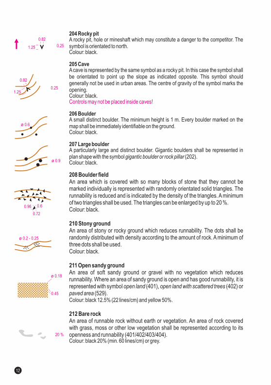
204 Rocky pit
205 Cave
206 Boulder
207 Large boulder
A rocky pit, hole or mineshaft which may constitute a danger to the competitor. Thesymbol is orientated to north.Colour: black.
Acave is represented by the same symbol as a rocky pit. In this case the symbol shallbe orientated to point up the slope as indicated opposite. This symbol shouldgenerally not be used in urban areas. The centre of gravity of the symbol marks theopening.Colour: black.
A small distinct boulder. The minimum height is 1 m. Every boulder marked on themap shall be immediately identifiable on the ground.Colour: black.
A particularly large and distinct boulder. Gigantic boulders shall be represented inplan shape with the symbol (202).Colour: black.
gigantic boulder or rock pillar
Colour: black 12.5% (22 lines/cm) and yellow 50%.
Colour: black 20% (min. 60 lines/cm) or grey.
Controls may not be placed inside caves!
208 Boulder field
210 Stony ground
211 Open sandy ground
212 Bare rock
An area which is covered with so many blocks of stone that they cannot bemarked individually is represented with randomly orientated solid triangles. Therunnability is reduced and is indicated by the density of the triangles. A minimumof two triangles shall be used. The triangles can be enlarged by up to 20 %.Colour: black.
An area of stony or rocky ground which reduces runnability. The dots shall berandomly distributed with density according to the amount of rock. A minimum ofthree dots shall be used.Colour: black.
An area of soft sandy ground or gravel with no vegetation which reducesrunnability. Where an area of sandy ground is open and has good runnability, it isrepresented with symbol (401), (402) or
(529).
An area of runnable rock without earth or vegetation. An area of rock coveredwith grass, moss or other low vegetation be represented according to itsopenness and runnability (401/402/403/404).
open land open land with scattered treespaved area
shall
5.3 WATER AND MARSH
0.18
0.18
100% (75%)
30%
0.180.50
0.25
0.21
0.25
0.82
1.25
0.210.37 1.87
(50%)
0.6
ø 0.37
0.45
ø 0.18
20 %
ø 0.2 - 0.25
0.6
0.72
0.96
ø 0.9
ø 0.6
0.251.25
0.82
0.251.25
0.82
12 13

303 Waterhole
306 Passable small watercourse
308 Narrow marsh
A water-filled pit or an area of water which is too small to be shown to scale. Thesymbol is orientated to north.Colour: blue.
The minimum dimension is 1 mm .
Acrossable watercourse less than 2 m wide.Colour: blue.
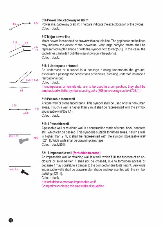
A marsh or trickle of water which is too narrow to be shown with symbol(310).Colour: blue.
304.1 Impassable body of water
305.1 Passable body of water
307 Minor watercourse
309 Impassable marsh
An area of deep water such as a lake, pond, river or fountain which mayconstitute a danger to the competitor or has forbidden access. The dark bluecolour and the bordering black line indicates that the feature cannot or shall notbe crossed.Colour: blue 100% or 75% (min. 60 lines/cm), black.
An area of shallow water such as a pond, river or fountain that can be crossed.The body of water shall be less than 0.5 m deep and runnable. If the body of wateris not runnable it shall be represented with the symbol(304.1). If no other line symbol touches the border of the passable body of water,the border shall be represented with a blue line.
A natural or man-made minor watercourse which may contain water only inter-mittently.Colour: blue.
Amarsh which is impassable or which may constitute a danger to the competitor.The feature cannot or shall not be crossed.Colour: blue, black.
2
impassable body of water
Colour: blue 30% (min. 60 lines/cm), blue.
marsh
(forbidden to cross)
(forbidden to cross)
It is forbidden to cross an impassable body of water!Competitors violating this rule will be disqualified.
It is forbidden to cross an impassable marsh!Competitors violating this rule will be disqualified.
204 Rocky pit
205 Cave
206 Boulder
207 Large boulder
A rocky pit, hole or mineshaft which may constitute a danger to the competitor. Thesymbol is orientated to north.Colour: black.
Acave is represented by the same symbol as a rocky pit. In this case the symbol shallbe orientated to point up the slope as indicated opposite. This symbol shouldgenerally not be used in urban areas. The centre of gravity of the symbol marks theopening.Colour: black.
A small distinct boulder. The minimum height is 1 m. Every boulder marked on themap shall be immediately identifiable on the ground.Colour: black.
A particularly large and distinct boulder. Gigantic boulders shall be represented inplan shape with the symbol (202).Colour: black.
gigantic boulder or rock pillar
Colour: black 12.5% (22 lines/cm) and yellow 50%.
Colour: black 20% (min. 60 lines/cm) or grey.
Controls may not be placed inside caves!
208 Boulder field
210 Stony ground
211 Open sandy ground
212 Bare rock
An area which is covered with so many blocks of stone that they cannot bemarked individually is represented with randomly orientated solid triangles. Therunnability is reduced and is indicated by the density of the triangles. A minimumof two triangles shall be used. The triangles can be enlarged by up to 20 %.Colour: black.
An area of stony or rocky ground which reduces runnability. The dots shall berandomly distributed with density according to the amount of rock. A minimum ofthree dots shall be used.Colour: black.
An area of soft sandy ground or gravel with no vegetation which reducesrunnability. Where an area of sandy ground is open and has good runnability, it isrepresented with symbol (401), (402) or
(529).
An area of runnable rock without earth or vegetation. An area of rock coveredwith grass, moss or other low vegetation be represented according to itsopenness and runnability (401/402/403/404).
open land open land with scattered treespaved area
shall
5.3 WATER AND MARSH
0.18
0.18
100% (75%)
30%
0.180.50
0.25
0.21
0.25
0.82
1.25
0.210.37 1.87
(50%)
0.6
ø 0.37
0.45
ø 0.18
20 %
ø 0.2 - 0.25
0.6
0.72
0.96
ø 0.9
ø 0.6
0.251.25
0.82
0.251.25
0.82
12 13
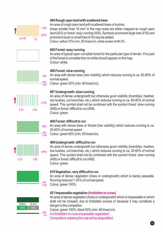
404 Rough open land with scattered trees
405 Forest: easy running
406 Forest: slow running
407 Undergrowth: slow running
408 Forest: difficult to run
409 Undergrowth: difficult to run
410 Vegetation, very difficult to run
421 Impassable vegetation
An area of rough open land with scattered trees or bushes.Areas smaller than 16 mm in the map scale are either mapped as
(403) or (405). Symbols (418) and(419) may be added.
An area of typical open runnable forest for the particular type of terrain. If no partof the forest is runnable then no white should appear on the map.Colour: white.
An area with dense trees (low visibility) which reduces running to ca. 60-80% ofnormal speed.Colour: green 30% (min. 60 lines/cm).
An area of dense undergrowth but otherwise good visibility (brambles, heather,low bushes, cut branches, etc.) which reduces running to ca. 60-80% of normalspeed. This symbol shall not be combined with the symbol(406) or (408).Colour: green.
An area with dense trees or thicket (low visibility) which reduces running to ca.20-60% of normal speed.Colour: green 60% (min. 60 lines/cm).
An area of dense undergrowth but otherwise good visibility (brambles, heather,low bushes, cut branches, etc.) which reduces running to ca. 20-60% of normalspeed. This symbol shall not be combined with the symbol(406) or (408).Colour: green.
An area of dense vegetation (trees or undergrowth) which is barely passable.Running reduced 1-20% of normal speed.Colour: green 100%.
An area of dense vegetation (trees or undergrowth) which is impassable or whichshall not be crossed, due to forbidden access or because it may constitute adanger to the competitor.Colour: green 100%, black 50% (min. 60 lines/cm).
.
2rough open
land forest: easy running prominent large treeprominent bush or small tree
forest: slow runningforest: difficult to run
forest: slow runningforest: difficult to run
Colour: yellow 70% (min. 60 lines/cm), white screen of 48.5%.
(forbidden to cross)
It is forbidden to cross impassable vegetation!Competitors violating this rule will be disqualified
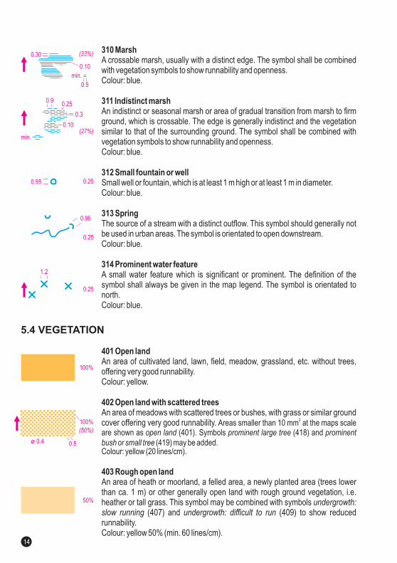
401 Open land
402 Open land with scattered trees
403 Rough open land
An area of cultivated land, lawn, field, meadow, grassland, etc. without trees,offering very good runnability.Colour: yellow.
An area of meadows with scattered trees or bushes, with grass or similar groundcover offering very good runnability.
.
An area of heath or moorland, a felled area, a newly planted area (trees lowerthan ca. 1 m) or other generally open land with rough ground vegetation, i.e.heather or tall grass. This symbol may be combined with symbols
(407) and (409) to show reducedrunnability.Colour: yellow 50% (min. 60 lines/cm).
Colour: yellow (20 lines/cm).
undergrowth:slow running undergrowth: difficult to run
Areas smaller than 10 mm at the maps scaleare shown as (401). Symbols (418) and
(419) may be added
2
open land prominent large tree prominent
bush or small tree
310 Marsh
311 Indistinct marsh
312 Small fountain or well
313 Spring
A crossable marsh, usually with a distinct edge. The symbol shall be combinedwith vegetation symbols to show runnability and openness.Colour: blue.
An indistinct or seasonal marsh or area of gradual transition from marsh to firmground, which is crossable. The edge is generally indistinct and the vegetationsimilar to that of the surrounding ground. The symbol shall be combined withvegetation symbols to show runnability and openness.Colour: blue.
Small well or fountain, which is at least 1 m high or at least 1 m in diameter.Colour: blue.
The source of a stream with a distinct outflow. This symbol should generally notbe used in urban areas. The symbol is orientated to open downstream.Colour: blue.
314 Prominent water featureA small water feature which is significant or prominent. The definition of thesymbol always be given in the map legend. The symbol is orientated tonorth.Colour: blue.
shall
5.4 VEGETATION
0.12
0.12
30%
60%
0.84
0.42
min.0.25
(14%)
(29%)
min.0.4
100% 50%
GREEN BLACK
min.0.25
min.0.25
100%
0.5ø 0.4
50%
0.7ø 0.55
70%
100%
0.25
1.2
(36%)
0.25
0.25
min.(27%)
(50%)
0.95
0.3
0.90.25
0.10
0.95
0.10
0.30
min.
0.5
(33%)
14 15
404 Rough open land with scattered trees
405 Forest: easy running
406 Forest: slow running
407 Undergrowth: slow running
408 Forest: difficult to run
409 Undergrowth: difficult to run
410 Vegetation, very difficult to run
421 Impassable vegetation
An area of rough open land with scattered trees or bushes.Areas smaller than 16 mm in the map scale are either mapped as
(403) or (405). Symbols (418) and(419) may be added.
An area of typical open runnable forest for the particular type of terrain. If no partof the forest is runnable then no white should appear on the map.Colour: white.
An area with dense trees (low visibility) which reduces running to ca. 60-80% ofnormal speed.Colour: green 30% (min. 60 lines/cm).
An area of dense undergrowth but otherwise good visibility (brambles, heather,low bushes, cut branches, etc.) which reduces running to ca. 60-80% of normalspeed. This symbol shall not be combined with the symbol(406) or (408).Colour: green.
An area with dense trees or thicket (low visibility) which reduces running to ca.20-60% of normal speed.Colour: green 60% (min. 60 lines/cm).
An area of dense undergrowth but otherwise good visibility (brambles, heather,low bushes, cut branches, etc.) which reduces running to ca. 20-60% of normalspeed. This symbol shall not be combined with the symbol(406) or (408).Colour: green.
An area of dense vegetation (trees or undergrowth) which is barely passable.Running reduced 1-20% of normal speed.Colour: green 100%.
An area of dense vegetation (trees or undergrowth) which is impassable or whichshall not be crossed, due to forbidden access or because it may constitute adanger to the competitor.Colour: green 100%, black 50% (min. 60 lines/cm).
.
2rough open
land forest: easy running prominent large treeprominent bush or small tree
forest: slow runningforest: difficult to run
forest: slow runningforest: difficult to run
Colour: yellow 70% (min. 60 lines/cm), white screen of 48.5%.
(forbidden to cross)
It is forbidden to cross impassable vegetation!Competitors violating this rule will be disqualified
401 Open land
402 Open land with scattered trees
403 Rough open land
An area of cultivated land, lawn, field, meadow, grassland, etc. without trees,offering very good runnability.Colour: yellow.
An area of meadows with scattered trees or bushes, with grass or similar groundcover offering very good runnability.
.
An area of heath or moorland, a felled area, a newly planted area (trees lowerthan ca. 1 m) or other generally open land with rough ground vegetation, i.e.heather or tall grass. This symbol may be combined with symbols
(407) and (409) to show reducedrunnability.Colour: yellow 50% (min. 60 lines/cm).
Colour: yellow (20 lines/cm).
undergrowth:slow running undergrowth: difficult to run
Areas smaller than 10 mm at the maps scaleare shown as (401). Symbols (418) and
(419) may be added
2
open land prominent large tree prominent
bush or small tree
310 Marsh
311 Indistinct marsh
312 Small fountain or well
313 Spring
A crossable marsh, usually with a distinct edge. The symbol shall be combinedwith vegetation symbols to show runnability and openness.Colour: blue.
An indistinct or seasonal marsh or area of gradual transition from marsh to firmground, which is crossable. The edge is generally indistinct and the vegetationsimilar to that of the surrounding ground. The symbol shall be combined withvegetation symbols to show runnability and openness.Colour: blue.
Small well or fountain, which is at least 1 m high or at least 1 m in diameter.Colour: blue.
The source of a stream with a distinct outflow. This symbol should generally notbe used in urban areas. The symbol is orientated to open downstream.Colour: blue.
314 Prominent water featureA small water feature which is significant or prominent. The definition of thesymbol always be given in the map legend. The symbol is orientated tonorth.Colour: blue.
shall
5.4 VEGETATION
0.12
0.12
30%
60%
0.84
0.42
min.0.25
(14%)
(29%)
min.0.4
100% 50%
GREEN BLACK
min.0.25
min.0.25
100%
0.5ø 0.4
50%
0.7ø 0.55
70%
100%
0.25
1.2
(36%)
0.25
0.25
min.(27%)
(50%)
0.95
0.3
0.90.25
0.10
0.95
0.10
0.30
min.
0.5
(33%)
14 15

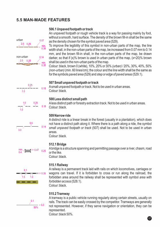
506.1 Unpaved footpath or track
507 Small unpaved footpath or track
508 Less distinct small path
509 Narrow ride
512.1 Bridge
515.1 Railway
515.2 Tramway
An unpaved footpath or rough vehicle track is a way for passing mainly by foot,without a smooth, hard surface. The density of the brown fill-in shall be the sameas the density chosen for the symbol (529).To improve the legibility of this symbol in non-urban parts of the map, the linewidth shall, in the non-urban parts of the map, be increased from 0.07 mm to 0.14mm, and the brown fill-in shall, in the non-urban parts of the map, be drawndarker, so that if (x)% brown is used in urban parts of the map, (x+20)% brownshall be used in the non-urban parts of the map.Colour: black, brown 0 (white), 10%, 20% or 30% / 20%, 30%, 40%, 50%
(min. 60 lines/cm); the colour and the line width shall be the same asfor the symbols (529) and (529.1).
Asmall unpaved footpath or track. Not to be used in urban areas.Colour: black.
Aless distinct path or forestry extraction track. Not to be used in urban areas.Colour: black.
A distinct ride is a linear break in the forest (usually in a plantation), which doesnot have a distinct path along it. Where there is a path along a ride, the symbol
(507) shall be used. Not to be used in urbanareas.Colour: black.
Abridge is a structure spanning and permitting passage over a river, chasm, roador the like.Colour: black.
A railway is a permanent track laid with rails on which locomotives, carriages orwagons can travel. If it is forbidden to cross or run along the railroad, theforbidden area around the railway shall be represented with symbol
(528.1).Colour: black.
A tramway is a public vehicle running regularly along certain streets, usually onrails. The track can be easily crossed by the competitor. Tramways are generallynot represented. However, if they serve navigation or orientation, they can berepresented.Colour: black 50%.
paved area
(urban)(non-urban)
paved area step or edge of paved areas
small unpaved footpath or track
area withforbidden access
411 Forest runnable in one direction
412 Orchard
413 Orchard, one direction (e.g. Vineyard)
414 Distinct cultivation boundary
415 Cultivated land
416 Distinct vegetation boundary
418 Prominent large tree
419 Prominent bush or small tree
420 Prominent vegetation feature
When an area of forest provides good running in one direction but less good inothers, white stripes are left in the screen symbol (406, 408, 410) to show thedirection with good runnability.Colour: green, white.
Land planted with fruit trees or bushes. The dot lines may be orientated torepresent the direction of planting.Colour: green, yellow.
Land planted with fruit trees or bushes, with a distinct direction of planting whichreduces the runnability. The green lines shall be orientated to show the directionof planting.Colour: green, yellow.
The boundary of symbol (415) whennot shown with other symbols (fence, wall, path, etc.) is represented with a blackline. A permanent boundary between different types of cultivated land is alsorepresented with this symbol.Colour: black.
Cultivated land which is seasonally out-of-bounds due to growing crops may beshown with a black dot screen.Colour: yellow, black 5% (12.5 lines/cm).
A distinct forest edge or very distinct vegetation boundary within the forest. Forindistinct boundaries, the area edges are shown only by the change in colourand/or dot screen.Colour: black.
Aprominent single tree.Colour: green.
Abush or a tree with a trunk less than 0.5 m diameter.Colour: green.
A vegetation feature which is significant or prominent. The definition of thesymbol shall always be given in the map legend. The symbol is orientated tonorth.Colour: green.
cultivated land (seasonally out of bounds)
(seasonally out of bounds)
5.5 MAN-MADE FEATURES
0.18
0.14
0.35
0.25
0.5
0.25
0.1
1.0
3.0
1.0
min.0.35
0.252.0
min.0.4
0.47
1.5
0.07
0.18
0.25
1.0
1.0
0.252.0
0.14
urban
non-urban
0.1
0.350%
min.0.35
ø 0.25
0.6
ø 0.75
0.25
1.2
0.07
0.8ø 0.2
0.95
0.25
ø 0.45 0.8
1.3
0.6
0.2 0.85
0.4
1.5
16 17
522 Passable fence or railing
524 Impassable fence or railing
525 Crossing point
526.1 Building
526.2 Canopy
A passable fence is a barrier enclosing or bordering a field, yard, etc., usuallymade of posts and wire or wood. It is used to prevent entrance or to confine ormark a boundary. A railing is a fencelike barrier composed of one or more hori-zontal rails supported by widely spaced upright poles, usually it can be slippedthrough.If a fence or railing is higher than 2 m or very difficult to cross, it shall be repre-sented with the symbol (524).Colour: black.
An impassable fence or railing, which shall not be crossed, due to forbiddenaccess or because it may constitute a danger to the competitor because of itsheight.Colour: black.
Acrossing point is a gap or an opening in a fence, railing or wall, which can easilybe passed through by a competitor.Small gaps or openings which can not easily be passed through by competitors,shall not be represented on the map and shall be closed during the competition.Colour: black.
Abuilding is a relatively permanent construction having a roof.Buildings within symbol (528.1) may just berepresented in a simplified manner.Areas totally contained within a building shallbe mapped as being a part of the building.The minimum gap between buildings and between buildings and other im-passable features shall be 0.40 mm.The black screen percentage should be chosen according to the terrain. A darkscreen gives a better contrast to passable areas, such as streets, stairways andcanopies, while a light screen makes contours and course overprint more clearlyvisible (which can be important in very densely built up urban terrain and in steepurban terrain). The black screen shall be the same for the whole map.Colour: black 50-65%, black.
A canopy is a building construction (with a roof), normally supported by pillars,poles or walls, such as passages, gangways, courts, bus stops, gas stations orgarages.Small passable parts of buildings which can not easily be crossed bycompetitors, shall not be represented on the map and shall be closed during thecompetition.Colour: black 20%, black.
impassable fence or railing
area with forbidden access
(forbidden to cross)
(forbidden to pass through or over)
It is forbidden to cross an impassable fence or railing!Competitors violating this rule will be disqualified.
It is forbidden to pass through or over a building!Competitors violating this rule will be disqualified.
516 Power line, cableway or skilift
517 Major power line
518.1 Underpass or tunnel
519 Passable stone wall
519.1 Passable wall
521.1 Impassable wall
Power line, cableway or skilift. The bars indicate the exact location of the pylons.Colour: black.
Major power lines should be drawn with a double line. The gap between the linesmay indicate the extent of the powerline. Very large carrying masts shall berepresented in plan shape or with the symbol (535). In this case, thecable lines can be left out (the map shows only the pylons).Colour: black.
An underpass or a tunnel is a passage running underneath the ground,especially a passage for pedestrians or vehicles, crossing under for instance arailroad or a road.Colour: black.
A stone wall or stone faced bank. This symbol shall be used only in non-urbanareas. If such a wall is higher than 2 m, it shall be represented with the symbol
(521.1).Colour: black.
A passable wall or retaining wall is a construction made of stone, brick, concreteetc., which can be passed. This symbol is suitable for urban areas. If such a wallis higher than 2 m, it shall be represented with the symbol(521.1). Wide walls shall be drawn in plan shape.Colour: black 50%.
An impassable wall or retaining wall is a wall, which fulfil the function of an en-closure or solid barrier. It shall not be crossed, due to forbidden access orbecause it may constitute a danger to the competitor due to its height. Very wideimpassable walls shall be drawn in plan shape and represented with the symbol
(526.1).Colour: black.
high tower
impassable wall
impassable wall
building
If underpasses or tunnels etc. are to be used in a competition, they shall beemphasized with the symbol (708) or (708.1)!
It is forbidden to cross an impassable wall!Competitors violating this rule will be disqualified.
crossing point crossing section
(forbidden to cross)
0.4
60º
3.75
0.75
0.14
0.9
0.25
0.9
1.4
0.14
50-65%
0.07
20%
min. 0.5 × 0.5
min. 0.4
min. 0.3550%
0.21
3.75
ø 0.6
0.25 0.25×
0.5
min.1.5
0.14 0.3
0.140.3
0.21
60º3.75
0.750.14
50% 65%
18 19
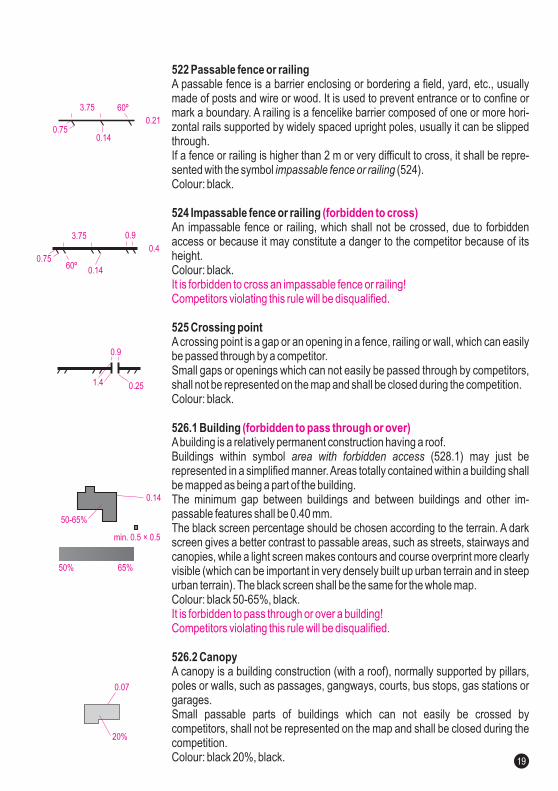
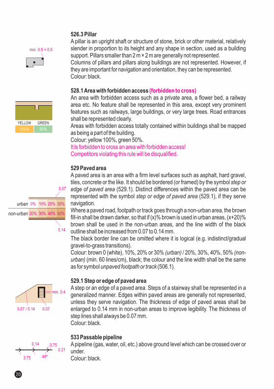
534 Impassable pipeline
535 High tower
536 Small tower
537 Cairn, memorial, small monument or boundary stone
538 Fodder rack
539 Prominent man-made feature
540 Prominent man-made feature
An impassable pipeline (gas, water, oil, etc.) above ground level which shall notbe crossed, due to forbidden access or because it may constitute a danger to thecompetitor because of its height.Colour: black.
A high tower or large pylon. Very large towers shall be represented in plan shapewith the symbol (526.1). The symbol is orientated to north.Colour: black.
An obvious small tower, platform or seat . The symbol is orientated to north.Colour: black.
Cairn, memorial, small monument or boundary stone more than 0.5 m high.Large massive monuments shall be represented in plan shape with the symbol
(526.1).Colour: black.
A fodder rack, which is free standing or attached to a tree. The symbol isorientated to north.Colour: black.
A man-made feature which is significant or prominent. The definition of thesymbol shall always be given in the map legend.Colour: black.
A man-made feature which is significant or prominent. The definition of thesymbol shall always be given in the map legend. The symbol is orientated tonorth.Colour: black.
building
building
(forbidden to cross)
It is forbidden to cross an impassable pipeline!Competitors violating this rule will be disqualified.
601 Magnetic north lineMagnetic north lines are lines placed on the map pointing to magnetic north. Theirspacing shall be 30 mm on the 1:5 000 map and 37.5 mm on the 1:4 000 map so inboth scales they represent 150 m on the ground.North lines may be broken where they obscure small features such as boulders,knolls, cliffs, stream junctions, path ends, etc.Colour: black or blue.
526.3 Pillar
528.1Area with forbidden access
529 Paved area
529.1 Step or edge of paved area
533 Passable pipeline
A pillar is an upright shaft or structure of stone, brick or other material, relativelyslender in proportion to its height and any shape in section, used as a buildingsupport. Pillars smaller than 2 m × 2 m are generally not represented.Columns of pillars and pillars along buildings are not represented. However, ifthey are important for navigation and orientation, they can be represented.Colour: black.
An area with forbidden access such as a private area, a flower bed, a railwayarea etc. No feature shall be represented in this area, except very prominentfeatures such as railways, large buildings, or very large trees. Road entrancesshall be represented clearly.Areas with forbidden access totally contained within buildings shall be mappedas being a part of the building.Colour: yellow 100%, green 50%.
A paved area is an area with a firm level surfaces such as asphalt, hard gravel,tiles, concrete or the like. It should be bordered (or framed) by the symbol
(529.1). Distinct differences within the paved area can berepresented with the symbol (529.1), if they servenavigation.Where a paved road, footpath or track goes through a non-urban area, the brownfill-in shall be drawn darker, so that if (x)% brown is used in urban areas, (x+20)%brown shall be used in the non-urban areas, and the line width of the blackoutline shall be increased from 0.07 to 0.14 mm.The black border line can be omitted where it is logical (e.g. indistinct/gradualgravel-to-grass transitions).Colour: brown 0 (white), 10%, 20% or 30% / 20%, 30%, 40%, 50%
(min. 60 lines/cm), black; the colour and the line width shall be the sameas for symbol (506.1).
A step or an edge of a paved area. Steps of a stairway shall be represented in ageneralized manner. Edges within paved areas are generally not represented,unless they serve navigation. The thickness of edge of paved areas shall beenlarged to 0.14 mm in non-urban areas to improve legibility. The thickness ofstep lines shall always be 0.07 mm.Colour: black.
A pipeline (gas, water, oil, etc.) above ground level which can be crossed over orunder.Colour: black.
step oredge of paved area
step or edge of paved area
(urban) (non-urban)
unpaved footpath or track
(forbidden to cross)
It is forbidden to cross an area with forbidden access!Competitors violating this rule will be disqualified.
5.6 TECHNICAL SYMBOLS
0.22
0.22
0.98
0.87
60º
ø 0.2
0.98
0.22
1.5
1.5
2.1
0.25
ø 1.2
1.2 0.22
1.5
0.221.5
0.180.14
0.07 / 0.14
100% 50%
YELLOW GREEN
0.210.75
3.75 45º
min. 0.4
0.14
0.14
urban
non-urban
0.07
0% 10% 20% 30%
20% 30% 40% 50%
0.14
0.40.75
0.9
45º3.75
0.07
min. 0.5 × 0.5
20
21
21
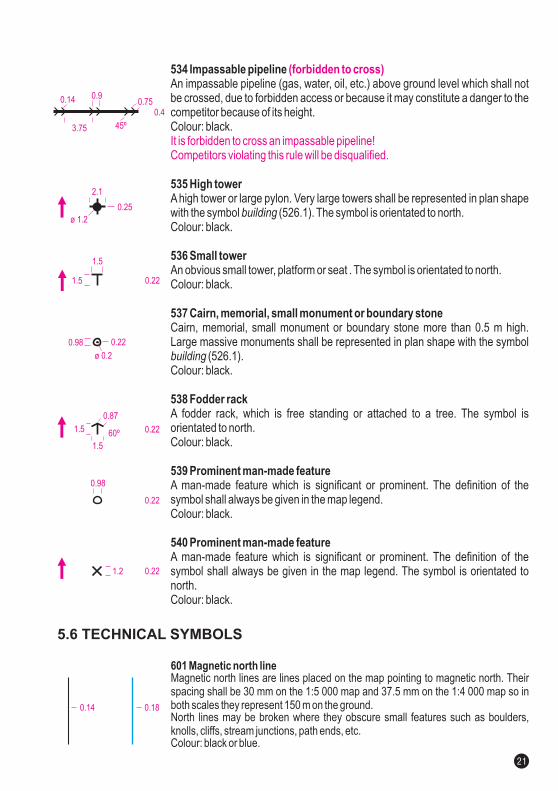
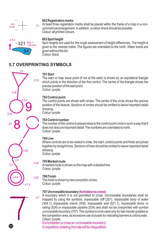
701 Start
702 Control point
703 Control number
704 Line
705 Marked route
706 Finish
707 Uncrossable boundary
The start or map issue point (if not at the start) is shown by an equilateral trianglewhich points in the direction of the first control. The centre of the triangle shows theprecise position of the start point.Colour: purple.
The control points are shown with circles. The centre of the circle shows the preciseposition of the feature. Sections of circles should be omitted to leave important detailshowing.Colour: purple.
The number of the control is placed close to the control point circle in such a way that itdoes not obscure important detail. The numbers are orientated to north.Colour: purple.
Where controls are to be visited in order, the start, control points and finish are joinedtogether by straight lines. Sections of lines should be omitted to leave important detailshowing.Colour: purple.
Amarked route is shown on the map with a dashed line.Colour: purple.
The finish is shown by two concentric circles.Colour: purple.
A boundary which it is not permitted to cross. Uncrossable boundaries shall bemapped by using the symbols: (201),(304.1), (309), (521.1),
(524) or (534) and shall not be overprinted with symbol(707). This symbol is to be used only for last minute updates to
the competition area, as excessive use of purple for indicating barriers is unfortunate.Colour: purple.
impassable cliff impassable body of waterimpassable marsh impassable wall impassable fence or
railing impassable pipelineuncrossable boundary
(forbidden to cross)
It is forbidden to cross an uncrossable boundary!Competitors violating this rule will be disqualified.
602 Registration marks
603 Spot height
At least three registration marks shall be placed within the frame of a map in a non-symmetrical arrangement. In addition, a colour check should be possible.Colour: all printed colours.
Spot heights are used for the rough assessment of height differences. The height isgiven to the nearest metre. The figures are orientated to the north. Water levels aregiven without the dot.Colour: black
708 Crossing point
708.1 Crossing section
709 Out-of-bounds area
712 First aid post
713 Refreshment point
714 Temporary construction or closed area
Acrossing point through or over a wall or fence, or across a road or railway or througha tunnel or an out-of-bounds area is drawn on the map with two lines curving out-wards.If underpasses or tunnels etc. are to be used in a competition, they shall be empha-sized with symbol (708) or (708.1).Colour: purple.
Acrossing section through or over a building, wall or fence, or across a road or railwayor through a tunnel or an out-of-bounds area is drawn on the map as a linear object,according to the plan shape.If underpasses or tunnels etc. are to be used in a competition, they shall be empha-sized with symbol (708) or (708.1).Colour: purple.
Out of bounds areas are mapped with the symbol (528.1).This symbol shall only be used for last minute updates to the competition map (e.g. forareas that may be dangerous for the competitors during the competition, or very latechanges to the competition terrain).An out-of-bounds area is shown with vertical stripes.Abounding line may be drawn if there is no natural boundary, as follows:- a solid line indicates that the boundary is marked continuously (tapes, etc.) on theground,- a dashed line indicates intermittent marking on the ground,- no line indicates no marking on the ground.Colour: purple.
The location of a first aid post.Colour: purple.
The location of a refreshment point which is not at a control or along the marked route.Colour: purple.
Obvious temporary constructions like platforms for spectators and speaker, closedarea for spectators, outside restaurant areas, etc. shall be represented in plan shape.Colour: purple 50%.
crossing point crossing section
crossing point crossing section
area with forbidden access(forbidden to cross)
(forbidden to cross)
It is forbidden to enter a temporary construction or closed area!Competitors violating this rule will be disqualified.
It is forbidden to cross an out-of-bounds area!Competitors violating this rule will be disqualified.
5.7 OVERPRINTING SYMBOLS
ø 0.3
321
54
6 pt. =1.52 mm
ø 5.0
ø 7.0
0.35
0.352.0
0.5
0.7
min.4 mm
0.1
0.6
0.25
0.35
0.9
3.0
0.35
1.5
(42%)
0.25
0.3 0.5
50%
3.05
3.7 0.35
1.03.0
1.1
3.0
22
7.0
ø 6.0
0.35
0.35
0.35
4.0
90.35
8
23
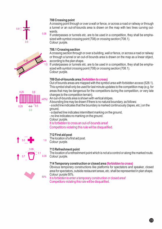
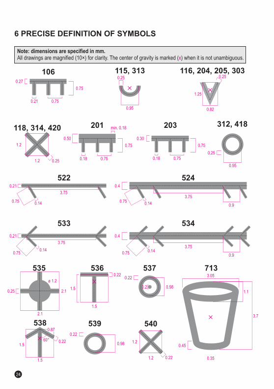
Note: dimensions are specified in mm.All drawings are magnified (10 ) for clarity. The center of gravity is marked ( ) when it is not unambiguous.× x
6 PRECISE DEFINITION OF SYMBOLS
522
0. 410. 57
5240.21 0.4
0. 41
3.75
0.9
3.750. 57
533
0. 410. 57
534
0.21 0.4
0. 41
3.75
0.9
3.75
0. 57
535
2 1.
2 1.
0.25
ø 1.2
536
1 5.
0.22
537
0.98
0.22
0.2
538
1 5.
60°
539
0 98.
0.22
540
1.2
1.2 0.22
0.87
0.22
1 5.
0.50
0.18
0.75
201
0.30
0.18
0.75
203
0.21
0.75
106 116, 204, 205, 303115, 313
0.27
1.25
0.75
0.25
0.75 0.75
min. 0.18312, 418
0.95
0.25
0.82
118, 314, 420
1.2
1.2 0.25
0.95
0.25
1 5.
0.35
3.7
3.05
713
1.1
0.45
24