integrated natural and anthropogenic risk …
TRANSCRIPT

Geographica Timisiensis, vol. 19, nr. 1, 2010 (pp. 33-49) ●
INTEGRATED NATURAL AND ANTHROPOGENIC RISK MANAGEMENT TOOLS FOR A BALANCED
URBAN DEVELOPMENT IN TÂRGU OCNA
Alexandru BĂNICĂ Romanian Academy, Iaşi Branch
Abstract. Risk management implies a decision making subjective process, namely of specific
measures as a response to potential risks. It is important the noticing of the systemic character of the
inter-relations that are established, for many times, among risks of different types. While the risk
analysis is an objective process mainly based on quantitative data, the management of the risks is a
subjective and qualitative process consisting in selection and implementation of measures in order to
obtain an acceptable risk level at reasonable costs. For an effective urban risk assessment, it is
necessary to establish the context, to identify, estimate, compare and rank different risks in order to
propose the best solution for their mitigation. Within the framework of case study - Târgu Ocna, a
small mining town that became a tourist spa-, the evaluation of strategic urban documents and public
perception in relation to risk events offer a suggestive preview on the complexity of the facts
interfering in decision making process. A useful method for adjusting authorities’ actions is
overlapping the identified risk areas with the building restrictions areas. Risk assessment is more
efficient if urban functionality is taken into account. The risk phenomena and urban dysfunctionalities
analysis within the functional areas refigures the role of their vulnerability (in terms of exposed
population and material goods densities) and of their capacity of recovery within the system. This
integrated approach represents a valuable framework in decision making process for a balanced urban
development and for improving the quality of urban life.
Rezumat. Instrumente integrate de gestionare a riscului natural şi antropic pentru o dezvoltare urbană echilibrată în Târgu Ocna. Managementul riscurilor implică un proces subiectiv de luare a
deciziilor, respectiv a unor măsuri de răspuns la acŃiunea potenŃială a fenomenelor de risc. Este
important să se Ńină cont de caracterul sistemic al inter-relaŃiilor care se stabilesc între riscuri de
diferite tipuri. Dacă analiza riscurilor este un proces obiectiv, bazat în principal pe date cantitative,
managementul riscurilor este un proces calitativ de selecŃie şi implementare a unor măsuri prin care să
se poată obŃine un nivel acceptabil al riscului la un cost rezonabil. Pentru o delimitare eficientă a
riscului urban este necesară stabilirea contextului teritorial, identificarea, estimarea, compararea şi
ierarhizarea diferitelor riscuri în vederea propunerii celor mai bune soluŃii pentru diminuarea acestora.
In cadrul studiului de caz al Târgului Ocna, un mic oraş minier restructurat turistic, evaluarea
documentelor cu caracter decizional şi a percepŃiei publice asupra riscurilor oferă o imagine sugestiva
asupra complexităŃii factorilor care intervin în procesul de luare a deciziilor. O metodă utilă pentru
ajustarea acŃiunilor autorităŃilor poate fi suprapunerea arealelor de risc identificate peste ariile
declarate ca fiind cu interdicŃii de construire. Evaluarea riscurilor poate fi mai eficientă dacă se Ńine
cont de funcŃionalitatea urbană. Analiza integrată a fenomenelor de risc şi a disfuncŃionalităŃilor
urbane în cadrul ariilor funcŃionale reconsideră rolul vulnerabilităŃii acestora (în funcŃie de densităŃile
de populaŃie şi bunuri materiale expuse) şi al capacităŃii de redresare în sistem constituie un cadru
firesc de luare a deciziilor în vederea unei dezvoltări urbane echilibrate şi a îmbunătăŃirii vieŃii
urbane.

● Integrated natural and anthropogenic risk management tools 34
Keywords: risk management, functional urban areas, vulnerability, public perception, decision making Cuvinte cheie: managementul riscului, arii funcŃionale urbane, vulnerabilitate, percepŃie publică, proces decizional
1. ASSUMPTIONS FOR A PROPER URBAN RISK MANAGEMENT
The subjective process of decision making regarding the future evolution and
organization of a town on a sustainable basis requires a good understanding of the systemic
character of interrelations that take place between functional/dysfunctional and risk inducing
elements. Whether the analysis of urban functionality and risks is an objective process based
predominantly on quantitative data and the calculation of probabilities, the functional
organization and management of risks are subjective and qualitative processes. They are
based upon the selection and the implementation of optimal measures to utilize the natural
and the socioeconomic environment until the maximum acceptable level of risk or costs are
being reached.
Thus the environmental objective assessment should be completed by two other
perspectives important for risk management decisions: the economic perspective – that
measures the expected utility and consequences and weight both risks and benefits- and the
psychological perspective applying perceptual filters that lead people to behave differently
than simple models of rationality would suggest (Linkov & Ramadan, 2004).
For the purpose of a good urban risk management is necessary to identify structural
and functional proper context related to the identification of risks, their assessment (by
analysis, evaluation and ranking) and treatment (mitigation). Since any system is complex
and dynamic - and especially one dominated by anthropogenic component- the whole
process must be continuously reiterated, monitored and revised, always keeping the
transparency and the consultation of the urban community exposed to risk (Fig. 1). The risk exposure is reflected by the concept of vulnerability as the estate and
perspectives of the structures that are sensitive to risky combinations of circumstances (Irina
Ungureanu, 2005). Assessing risk and vulnerability comprises a systematic process of
analysis (context setting, risk identification, description and estimation) and evaluation
(AIRMIC, ALARM, IRM: 2002).
For a valuable context setting, our case study valuates both the results of local and
regional decision making documents and of public perception surveys. In 2007-2008, first as
a basis for the Strategic Plan for Development of Târgu Ocna and then as a completion for
our works, there has been made a major survey with the extent of the sample population of
447 respondents (for o total population of about 13000 inhabitants). The sample population
was two-stages, quasi-probabilistic and stratified (by place of residence, sex and age).
Present paper evaluates some specific risk management tools and an integrated approach of
urban threats in Târgu Ocna town by risk identification - overlapping the observed and
mapped areas to the building restricted areas, qualitatively analysing the risks and
dysfunctionalities within the functional urban areas-, followed by comparative and integrated risk assessment – based on calculating within a risk matrix the weight of
different dysfunctional elements and events, also taking into account the urban areas
vulnerability in order to offer a tool for prioritization of the needed administrative measures.

Alexandru BĂNICĂ ● 35
Fig. 1 The risk management process model (AS / NZS 4360:2001)
Un model al procesului de management al riscului
2. ASSESSMENT OF THE PRIORITIES ASSUMED BY THE LOCAL AUTHORITIES AND THE PUBLIC PERCEPTION OF RISK AND
ENVIRONMENTAL ISSUES
A useful tool for risk identification and assessment for an urban settlement can be
done either by analyzing the preferences expressed by the decision-makers through
interviews, questionnaires, etc., or by emphasizing the priorities revealed through intents
stated in plans, programs, local and regional strategies, made public through conferences and
public meetings, directly disseminated leaflets or the activity of public information offices,
or on one side, and the precise actions decided by the authorities.
At regional level general directions and strategic measures are elaborated for the
mitigation of environmental risks and the improvement of environmental quality, but often
such measures do not underlie on a sound analysis of local realities and thus, these are
lacking a proper finality. Thus, in the case of Târgu Ocna town, the Bacău County Strategy
for Sustainable Development indicates, for the environmental component, besides the
completely justified measures for preventing flooding, some other measures addressing the
improvement of air quality (although this is obviously not one of the real problems here as it
is in the other towns from Trotuş Valley), instead of measures for the forest protection which
are obviously needed here, as in the case of Slănic Moldova.
By studying the preparatory documents used for the elaboration of the Sustainable
Development Strategy for Târgu Ocna, the Strategy itself, the Urban Master Plan, and other
diversified information provided by the local authorities, including those published on their
official web page, the identification of some general objectives and priorities was possible.
These objectives are aiming to reduce some dysfunctionalities induced by the tourism

● Integrated natural and anthropogenic risk management tools 36
infrastructure and the economic environment, by rehabilitating the basic infrastructure and
the improving the access of population and economic agents to permanent and quality
services, by conserving and protecting the natural environment, by ensuring the access to the
natural and historical patrimony and also by encouraging and improving the social cohesion
and inclusion.
The objectives proposed for the management of territorial urban planning and
residential fund aim for bringing up to date the Urban Master Plan and the land property
database. Meanwhile, measures for supporting the existing associations of owners to
rehabilitate the built-up fund, to rehabilitate the heating system for the public buildings and
the flats, to build new social residences and accomplish a fiscal zoning for the administrative
territory of the town are taken. One of the priorities for the local administration is the
modernization of the road and public illuminating infrastructure by eliminating the existent
dysfunctionalities in the area of maximum traffic and by consolidating and rehabilitating the
damaged access roads (mainly by landslides and flooding).
Concerning risk phenomena manifestation (i.e. the emergency situations) the
accomplishment of a warning system in case of pollution, floods or earthquake is proposed.
Meanwhile the information and the training of the population for such situations and the
“ecological” education in schools and in highschool are needed. The local risk management
system emphasizes the treating of the effects instead of removing the cause producing these
events. For example reconstructing the bridges without building safe bank defences for
Trotuş, Slănic and Vâlcele rivers it is not a sustainable action taken by the local authorities.
The public perception over the environment, as a distinguishable concept, is
associated to the idea of systemic crisis. The environment is often linked, in the public
perception, with the obvious, visible dysfunctionalities, which have destructive effects (e.g.
severe pollution). In consequence, the hierarchy of intervention measures dedicated to the
improvement of environmental quality is wrongly overlapping, in the collective mental, with
the immediate necessities for the reduction of risk. The field experience, the discussions
held with the inhabitants, and most of all, the poll based on sociological technique of
sampling, data processing and analysis, proved to be very useful for the investigation of the
public perception over the necessities of the local system.
Reforestation is considered as the main priority by 44% of the inhabitants, even if the
percentage of the forested area is relatively high. The areas where reforestation is perceived
as immediately needed are those in the north-eastern part of the town and in the hilly area
around the component village Vâlcele. In the same time, the reforestation of areas affected
by landslides, mud flows and torrents/gullies, which are directly affecting the inhabitants in
Poieni, Tiseşti or Gura Slănic, is perceived as a priority by the inhabitants of these
neighbourhoods. This is stated by 56%, respectively 57% of the population asked from Gura
Slănic and Tiseşti, although they also agree for the necessity of stimulating the activities of
forestry and wood industry (most of them are actively engaged in).

Alexandru BĂNICĂ ● 37
Fig. 2 Public perception on ranking measure to improve environmental issues
The level of general urban endowment for different areas in Târgu Ocna influences
not only the quality of living but also the quality of environment. The lack of some public
utilities, such as the sewerage system, is perceived as being acute by the population living at
the outskirts of the town, but there are also cases where this lack is almost completely
ignored. Thus, in Poieni and Tiseşti the construction of a sewerage network and a
wastewater treatment plant is considered as a priority by 44%, respectively 29% of the
persons interviewed, compared to only 7% of those in Gura Slănic, although none of them
are connected to the municipal sewerage system. In the context of a desired sustainability, it
is promising that 30% of the respondents and the local authorities acknowledged the need
for environmental education and information, which has to be done through the public
educational system by permanent information and awareness campaigns regarding the risks
of overall environmental degradation.
There is an incontestable link between the elements perceived as dysfunctional and
the necessity for punctual or structural investments. In this respect, the public perception is a
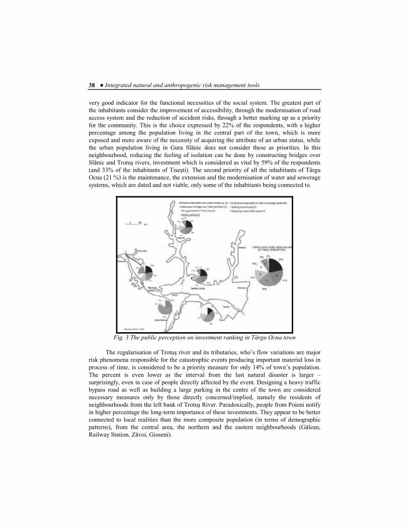
● Integrated natural and anthropogenic risk management tools 38
very good indicator for the functional necessities of the social system. The greatest part of
the inhabitants consider the improvement of accessibility, through the modernisation of road
access system and the reduction of accident risks, through a better marking up as a priority
for the community. This is the choice expressed by 22% of the respondents, with a higher
percentage among the population living in the central part of the town, which is more
exposed and more aware of the necessity of acquiring the attribute of an urban status, while
the urban population living in Gura Slănic does not consider these as priorities. In this
neighbourhood, reducing the feeling of isolation can be done by constructing bridges over
Slănic and Trotuş rivers, investment which is considered as vital by 59% of the respondents
(and 33% of the inhabitants of Tiseşti). The second priority of all the inhabitants of Târgu
Ocna (21 %) is the maintenance, the extension and the modernisation of water and sewerage
systems, which are dated and not viable, only some of the inhabitants being connected to.
Fig. 3 The public perception on investment ranking in Târgu Ocna town
The regularisation of Trotuş river and its tributaries, who’s flow variations are major
risk phenomena responsible for the catastrophic events producing important material loss in
process of time, is considered to be a priority measure for only 14% of town’s population.
The percent is even lower as the interval from the last natural disaster is larger –
surprisingly, even in case of people directly affected by the event. Designing a heavy traffic
bypass road as well as building a large parking in the centre of the town are considered
necessary measures only by those directly concerned/implied, namely the residents of
neighbourhoods from the left bank of Trotuş River. Paradoxically, people from Poieni notify
in higher percentage the long-term importance of these investments. They appear to be better
connected to local realities than the more composite population (in terms of demographic
patterns), from the central area, the northern and the eastern neighbourhoods (Gălean,
Railway Station, Zăvoi, Gioseni).

Alexandru BĂNICĂ ● 39
3. ASSUMPTIONS FOR A QUALITATIVE APPROACH OF RISK ASSESSMENT
The stages of analysis, evaluation and ranking of risks are fundamental for the
continuous process of risk management. The authorities’ errors largely came from their
inability for integrating data delivered by monitoring process and obtaining high quality
information, which should offer an objective picture and a summary of the main needs and
priorities for action. Therefore, on the one hand, it is necessary to compare the risk areas
reported in the local administrative documents (such as Urban Master Plan) with those
suggested by the geographical analysis, by mapping and field observations and
investigations. On the other hand it is important to elaborate some quantitative indicators in
order to evaluate the risk phenomena threatening the analysed urban habitat and to present a
synthetic image of local intervention necessities.
Decision making documents for local authorities establish specific measures to
reduce natural or anthropogenic risks’ effects. The imposing of specific restrictions by the
authorities must be based on a correct assessment of urban areas according to the probability
of risk phenomena apparition. According to the Urban Master Plan there can be made a
strict distinction within the whole built urban area and within each territorial reference unit
(TRU), between the land without building restrictions (if their peculiarity and functionality
are being complied with) and areas with restrictions. These areas were divided in temporary improper for building surfaces - if the risky element in the system can be resolved within
the foreseeable future-, land taken to be unusable - if the element of risk is impossible to
eliminate without major changes of the local environment, land with irrevocable prohibition for building - the element of risk is serious and very difficult to eliminate in a foreseeable
time - and land exposed to an imminent, possibly catastrophic, risk event (exploitation area
of the salt wells which could collapse at any time).
Areas considered to be temporary restricted for building until de
confirmation/invalidations of their existence and the possibility for the risk manifestation
overlap with some sectors from Poieni, Păcurele, Vâlcele, Mosoare and Gălean quarters.
Restrictions considered to be certain and irrevocable are imposed for a big area form Gura
Slănic quarter. Both de natural and anthropogentically induced pseudokarst processes have
already created significant damage – many houses being destroyed or demolished, others
expropriated. The actual manifestation of sufozionale processes is typical for only a smaller
area, where the hazard for some salt wells to collapse is considerable and also the sector in
which Groapa Burlacului (4800 sqm) formed. Another category of urban areas in Târgu
Ocna are those considered to be unusable – situated mainly in the low Valley of Trotuş
River and its main tributaries.

● Integrated natural and anthropogenic risk management tools 40
Fig. 4 Risks and land use restrictions in Târgu Ocna town (Al. Bănică, 2009)
Riscuri şi restricŃii de utilizarea a terenurilor în oraşul Târgu Ocna
Overlapping the Map of building restricted areas with the one of natural hazards
and with the areas considered to be dysfunctional in terms of human activities (these
includes mainly the municipal waste platform, the wastewater treatment plant and Forseco
and Cosna factories – in mining and furniture sectors - located in the low floodplain) shows
the extent to which the existing urban management plans take into account the real
possibilities of generating unwanted events. Part of hazard phenomena, especially soil
erosion and gravity driven processes occur outside the built-up area but they often appear
nearby. Their development should be continuously monitored to control the induced chain
reaction effects. Moreover, such processes manifesting also within the build-up area are not
always matching with building restrictions areas (for e.g. in Vâlcele or in Poieni quarters). Meanwhile, the risk for pseudokarst processes is overestimated as deployment areas,
particularly in terms of permanent building restrictions. Studies made by the Institute of
Mining Research and Design, Cluj-Napoca (2006) have shown that the occurrence of these
phenomena reduced (because of the cut to a minimum of the exploitation by salt water
injecting into underground), so that some small tourist accommodation may be permitted
outside the area with active suffosion processes.
The greatest damage and the most destructive effects in the system are induced by
flood event risk. The danger of occurrence for some events comparable to those from July
2005 in always present if authorities will not take some effective measures by raising the
existing dams and building new ones. A flood occurring once in ten years (10% probability)
would affect only the buildings from the low Trotuş Valley, while an exceptive event

Alexandru BĂNICĂ ● 41
occurring once in a hundred years (1% probability) would lead to flooding of large areas of
the town.
Establishing the risk areas should be completed by fixing the boundaries of functional
areas as a territorial framework where the environmental problems could be tackled. An
instant solution is the adoption of the official scheme represented by territorial reference
units (TRU). Nevertheless such an approach is difficult to manage because of the big
number of unities that one should operate with and because of their often mono-functional
profile. Based on functional complementarities criteria and taking into consideration the
limits and the identified geographical discontinuities, there have been established 11 urban
areas generally corresponding to some old neighbourhoods (“mahalale”) having its own
identity within the urban organism.
A synthetic analysis of dysfunctional issues and the risk factors for each of the
identified quarters reveals some peculiar issues.
The Central area has its biggest extent, on the rocky terrace of 10-15 m of the Trotuş
River. It is not exposed to geomorphologic and hydrologic risks, excepting the sector
situated on the low terrace of Trotuş River, where flooding can produce damages and an
area near the Station “Salina”, due to ground subsidence in salt rocks. Among the peculiar
dysfunctions of this area worth mentioning the existence of non-modernised roads and of
some conflict intersections, the buildings in a high degree of degradation (with collapse risk
in case of earthquake), lack of reliability and weariness of the pipelines for water supply and
sewerage (asbestos-cement, steel, cast iron, cement- all degraded over time) and the poor
maintenance of some green areas. All these are overlapping with a high population and
buildings density, which increases the real value of the risk. The Western peri-central quarter is situated on the both banks of Vâlcele Creek, including some residential areas
(Văleni, łărăncuŃa) and the salt mining sector. The area has a medium risk for flooding in
the condition of flow variations; the nowadays active geomorphologic processes have a low
occurrence. On the other side, the secondary road infrastructure is not modernised, the area
has no sewage infrastructure, the waste management is unsound (few waste bins, rarely
collected by the waste company), the buildings are prevalent of rural type some in the
advanced stage of degradation and the green areas almost non-existent. Worth mentioning is
also the weak organisation of the proximity services and facilities, however advantageous
comparing to other areas from the proximity of the central area. The peri-Central eastern quarter partially overlapping to Gioseni slum is located mainly on the rock terrace of 10-15
m but also on the lower terrace of Trotuş River. Here the probability of flood recurrence is
high in special flow conditions after periods of heavy raining. In what concerns other
aspects, it is similar with western peri-central quarter, except that the density of buildings is
higher in this aria, the constructions are more concentrated and the population has some
advantages in terms of access to domestic services and to working places. The most eastern sector of the town is an industrial area, partly situated on the low terrace of 5-6 m of Trotuş
River with high risk of flooding. Within this area, it is located the wastewater treatment
plant and the former landfill site, both important polluting sites.

● Integrated natural and anthropogenic risk management tools 42
Fig. 5 Functional urban areas
Zonele urbane funcŃionale (1- Central area; 2- Western peri-central area; 3- Peri-central eastern quartier; 4- Eastern
industrial district; 5- Gura Slănic; 6-Tiseşti; 7- Gălean; 8-Vâlcele; 9- Mosoare; 10- Poieni; 11-
Păcurele) (Source: Orthophotoplans of Târgu Ocna territorial unit) (1- Zona centrală; 2- Zona pericentrală de vest; 3- Cartierul pericentral de est; 4- Zona
industrială de est; 5- Gura Slănic; 6-Tiseşti; 7- Gălean; 8-Vâlcele; 9- Mosoare; 10- Poieni; 11- Păcurele) (Source: Orthophotoplans of Târgu Ocna territorial unit)
Gura Slănic, Tiseşti, Gălean, Vâlcele, Mosoare, Poieni and Păcurele quarters are,
by one hand, all semi-urban or quasi-rural areas having poor secondary road infrastructure
(not modernised, made by ballast or even clay), do not dispose of all urban utilities (for e.g.
Gura Slănic and Tiseşti are not connected to gas and sewage networks, while Păcurele lacks
all utilities), have poor waste management, do not have organised green areas and are low
endowed with proximity facilities and services (commercial, sanitation, educational etc.).
Besides these dysfunctionalities, the mentioned areas are exposed to risks that are harder to
counteract. Placed at the river mouth of Slănic River into Trotuş River, Gura Slănic Quarter
represents the most disadvantaged area from a natural hazard point of view, encompassing a
large area with construction interdiction, due to the suffosion, crumbling and caves in
processes, caused mainly because of salt exploitation and of flooding area relatively large.
Partly placed on the low terrace of Trotuş River, Tiseşti quarter has a higher level risk of
flooding and also some sectors facing the risk of land sliding at the basis of the homonym
hill. In Vâlcele quarter land sliding and sheet or gully erosion affects the houses situated
near the boundaries of the build-up area, while the risk of flooding is medium during the
creek flow variations. Landslides and gully erosion also threats the Poieni quarter, while the
risk of flooding is higher on the low 5-6 m terrace. Nearby, Mosoare and Păcurele are even
more exposed to disastrous inundations. The last is the most disadvantaged and vulnerable in

Alexandru BĂNICĂ ● 43
terms risk phenomena overlapping natural hazards (flooding and gravity driven processes)
and the lack of common living facilities: low accessibility to utilities, to public and private
services and even to road infrastructure (extreme isolation due to the damages of the bridge
over Trotuş River in 2005).
4. COMPARATIVE AND INTEGRATED RISK ASSESMENT
The qualitative assessment of dysfunctionalities and risk phenomena in the 11 urban
areas is needed, but not sufficient for the decision making process. Local authorities should
prioritize the measures taking into account some quantitative indicators regarding the
intensity and conceivable effects of the identified environmental issues/failures and of the
potentially destructive events on the exposed population and material goods.
Târgu Ocna is one of Romania’s lowest population density towns (12.4
inhabitants/ha). This fact is mainly due to the strong tentacle extension on Trotuş Valley and
its tributaries, through agglutination of some localities with rural character, and, therefore,
with low population density. Other explanations are the agricultural land use for 50% of the
build-up area as well as the existence of many and large vacant or unbuildable fields. The
assessment is demonstrated by the low values of population, buildings and residences
densities. In terms of risk assessment this fact has positive valences, meaning less exposure
at least for certain sectors of the towns. The central area concentrates the highest densities of
population– the average value is 79 inhabitants/ha and 27 buildings/ha. The density
diminishes so that it is possible to ascertain a gradient for buildings dispersion as we move
away from the central district: the pericentral areas are denser– specially the eastern one
(Gioseni-Tăbăcari) with 47 inhabitants/ha respectively 16 houses/ha. In Zăvoi-Railway
Station and łărăncuŃa-Văleni sectors the densities decrease to 11 inhabitants/ha by including
some agriculture lands and large non-efficient fields. The two sites from the right Trotuş
bank and the constituent rural activities have population densities distinctive for the hill-
mountain contact villages. The values are even smaller for Gura Slănic as the area was
depopulated because the irrational mining activities, while the eastern periphery is the most
dispersed – under 5 inhabitants/ha in Gălean, Viişoara and especially in the industrial area.
Risk assessment was taking into account the possibility of recovery within the system
as the manifestation/expression of certain risk phenomena involve difficult remediable
consequences, while others have negative effects easier to control and to balance. The risks
with locally hard to remediate effects are, mainly, natural hazards induced by present
geomorphologic processes (gravity driven slumping or associated to pseudokarst processes
in raw salt) and the hydrological hazards (flooding).

● Integrated natural and anthropogenic risk management tools 44
Fig. 6 Population (a) and buildings (b) density in Târgu Ocna
(Data source: Târgu Ocna townhall, 2007)
PopulaŃia şi densitatea clădirilor în Târgu Ocna (Sursa: Primăria oraşului Târgu Ocna, 2007)
Other factors and circumstances that induce more easily to control and remediate
hazards - if there is the will and the administrative capacity - are represented by a variety of
failures involving unreliable communication network (such as accessibility and quality of
transport infrastructure), houses and heritage buildings of poor quality, the lack or scarcity
of public utilities (water, sewer, gas, telephone network, public lighting), small surface and
poor quality of green areas, poor waste management, dysfunctionalities in providing public
services, social risks. All these issues were awarded scores according to the possibility of
remediation of the risk and dysfunctional phenomena within the system: from 1 to 5 for the
difficult remediable (caused by natural environment dynamics are difficult or impossible to

Alexandru BĂNICĂ ● 45
refute) and from 1 to 3 for those depending on the ability of decision centres and systems’
reserves for the actions of remediation. Based on a simple calculation formula, a risk
indicator was obtained after integrating all these partial indicators.
Tab. 1. Târgu Ocna’s functional areas- risk matrix Zonele funcŃionale din Târgu Ocna – matricea riscului
(Risks generated by: A- Gravity driven geomorphologic processes, B- Pseudokarst in salt, C-
Hydrological processes and phenomena, D- Communications network, E- The quality of
houses and patrimony buildings, F- Public utilities (averages, underestimated capacity), G-
Green areas (small surfaces per capita, inhomogeneous distribution, inappropriate
management), H- Waste management, I- Lack of proximity facilities, J- Social risks
Ir= (∑Rgr + ∑Rur) /10 Ir - risk index; Rgr - risks with hard recoverable effects (1 to 5 scale) ; Rur - risks with easy
recoverable effects (1 to 3 scale) ;
10 – number of analysed phenomena
Iv = Ir² * Ier /3 Ier = Ipe * Ibe/2 Iv = Vulnerability index Ier = Risk exposure index
Ipe = Exposed population index – values from 0.1 to 0.5; Ibe = Exposed material goods index
(buildings) – values from 0.1 to 0.5
The vulnerability of a territory depends on the manifestation probability of a risk
phenomenon and the exposed elements represented mainly by population and material
goods. This utilitarian criterion is essential in administrative decisions making process.
In order to determine the degree of vulnerability for the homogenous identified areas,
we have developed an synthetic indicator taking into account on the one hand the extent of
the risk, and on the other hand the population and properties at risk (there have been
considered only the residential buildings, although, naturally, but hardly quantifiable,
institutions, economic facilities, and particularly cultural and historical heritage are
extremely important assets at risk). Exposure index was composed as an average value of
the exposed population and exposed material goods indexes. In preparing the final

● Integrated natural and anthropogenic risk management tools 46
vulnerability index has been given more weight to risk indicator (by raising the power of the
number to two) and less to exposure index.
Tab.2. Vulnerability index for urban areas in Târgu Ocna town Indicele de vulnerabilitate pentru cartierele din Târgu Ocna
Urban area Area
The density of buildings
The density of residences
Residences exposure index
Population density
Exposed population index
Vulnerability index
ha buildings/
ha
residences
/
ha
inhab./ha
1 Central area 68,32 5,78 27,96 0,50 78,75 0,50 0,63
2 The western peri-central
quartier
81,9 3,52 4,04 0,07 11,60 0,12 0,18
3 The eastern peri-central
quartier
49,7 8,95 16,18 0,30 46,96 0,47 0,65
4 The Eastern industial
area
84,3 0,93 0,89 0,02 4,28 0,04 0,06
5 Gălean 105,17 1,73 2,29 0,04 4,82 0,05 0,08
6 Vâlcele 113,2 3,30 3,34 0,06 9,58 0,10 0,17
7 Gura Slănic 114,43 3,14 3,14 0,06 8,07 0,08 0,17
8 Tiseşti 69,75 4,92 4,92 0,09 18,45 0,18 0,29
9 Poieni 10,95 4,11 4,11 0,08 12,79 0,13 0,20
10 Păcurele 48,36 4,05 4,05 0,08 11,04 0,11 0,26
11 Mosoare 15,69 4,84 4,84 0,09 14,15 0,14 0,25
Obviously, the central, highly populated area appears as the most exposed to possibly
manifesting risks, while the peripheral areas, where such risks are actually presently active,
have lower densities of population and a lesser value of material goods exposed. This fact
decreases the value of the vulnerability index in the perception of general public and local
authorities (which take decisions in a narrow-minded, utilitarian manner, according to the
number of persons affected by risk phenomena and not by the intensity and the impact of
such risks). The main resulting consequence is that of slowing down some necessary
measures aiming at the prevision, prevention and mitigation of major risk impacts in areas
placed at the periphery of the system, but whose role as reservoirs is indisputable (and which
are also inhabited).

Alexandru BĂNICĂ ● 47
Fig. 7 Spatial distribution of risk (a) and vulnerability
to major risk phenomena (b) index in Târgu Ocna DistribuŃia spaŃială a riscurilor (a)
şi indicele de vulnerabilitate la fenomene de risc major (b) în Târgu Ocna
Even more relevant, in our case, is the spatial distribution of the vulnerability index,
calculated for major risk phenomena (which are the most difficulty remediable in the
system). In establishing this index, the area exposed to a risk and the existing endowments
designed for the prevention and mitigation of risks (canal embankments, banks, dams, etc.)
have been equally taken into account. Areas with a higher density of population and
residences are considered to be disadvantaged compared to those with a more scattered

● Integrated natural and anthropogenic risk management tools 48
population and built-up area. By this approach, the most vulnerable areas are Gura Slănic,
Păcurele and Mosoare, followed by Tiseşti and Poieni quarters, with their relatively wide
floodable areas and by Vâlcele with landslides and mud flows. A medium vulnerability has
been assigned to the eastern industrial area and the western peri-central area – with
relatively wide floodable areas but with lower density of buildings. The less vulnerable to
major risks are the central area, placed on the rocky river terrace of 10 m and secured, the
eastern peri-central area (representing about 9% of the total floodable area - in Tăbăcari
sector) and Gălean neighbourhood (relatively little affected by the unregulated flow of the
homonym creek and by landslides).
For a balanced administrative urban decision making process, capable to ensure the
security of its own inhabitants and their material goods, it is necessary to attain compatibility
between the processes representing risks and the decisions for preventing them, in order to
minimize the negative risk effects and to maintain the proper functionality of the system.
CONCLUSIONS
Sustainable management decisions for risk events and general dysfunctionalities
existing in the urban system should be carefully tackled by the local authorities, depending
on the needs of various urban areas and taking into account, simultaneously, public
perception, regulatory decision making documents and grounded assessments based on
qualitative and quantitative risk and vulnerability evaluation. Meanwhile, it is important to
assess not only the territorial differences or structural and functional lack of
homogeneousness, but also the overall functioning of the system. At local level, minor
dysfunctionalities can be crucial obstacles in the way of o balanced development, so an
integrated approach can offer a clear perspective on the priorities of action therefore
becoming a useful tool in urban decision-making process. Considering any system (and
especially the urban environment) as being complex and dynamic, the entire process must be
reiterated, continuously monitored and revised, taking into account the communication and
population involvement, namely of the urban community exposed to risk.
BIBLIOGRAPHY
Cosma, D., Cosma, O., (2009), Modern Risk Management Strategies for the Romanian State Treasury, Online at http://mpra.ub.uni-muenchen.de/20425/ ; MPRA Paper No. 20425,
posted 04.02.2010/ 4:15.
Fairman, R. şi colab., (1998), Environmental Risk Assessment – approach, expenses and information sources, Monitoring and Assessment Research Center, King’s College London,
European Environmental Agency, Environmental issue report no.4 .
Linkov, I., Ramadan A.B. (2004), Comparative risk assessment and environmental decision making, Kluwer Academic Publishers, Netherlands.
Şandru, I. , (1966), Târgu Ocna. ConsideraŃii de geografie urbană, Scientific annals. Al. I. Cuza, s.
II, t. XII, Iaşi.
Ungureanu, Irina, (2005), Geografia mediului, Ed. Univ. Al. I Cuza, Iaşi.

Alexandru BĂNICĂ ● 49
Ungureanu, Irina, Bănică AL., (2008), Possibilities of Operationalizing the Concept of Sustainable Development in the Spatial and Functional Evolution of Târgu Ocna Town, volume 2,
Present Environment and Sustainable Development, Editura UniversităŃii Al. I. Cuza, Iaşi.
* * *, (2002), A risk management standard, AIRMIC – ALARM - IRM (The Institute of Risk
Management).
http://www.theirm.org/publications/documents/Risk_Management_Standard_030820.pdf,
United Kingdom.
* * *, (2001), AS/NZS 4360:2001 – Risk Management Standards Australia/ Standards New
Zeeland/Sydney/ Wellington.
* * *, (2006), Măsurători batimetrice la Groapa Burlacu –Târgu Ocna în vederea urmăririi evoluŃiei surpărilor şi dizolvărilor , Institute of Mining Research and Design (MINESA),
Cluj-Napoca.
* * *, (2000), Planul urbanistic General al oraşului Târgu Ocna.
* * *, (2007), Sondaj de opinie realizat în vederea elaborării Planului Strategic de Dezvoltare –Târgu Ocna, Made by S.C. Advance S.R.L. Cluj-Napoca,
* * *, (2007), Strategia de dezvoltare durabilă a oraşului Târgu Ocna.
* * *, (2005), Planul de amenajare a teritoriului judetean Bacău etapa a IV-a / martie 2005 -
Strategia de dezvoltare a judetului Bacău, Institute for Housing and Urban Development
Studies (IHS) Romania SRL