integrated intermodal transport in daerah istimewa yogyakarta 2e intermodal... · since yogyakarta...
TRANSCRIPT

INTEGRATED INTERMODAL TRANSPORT IN DAERAH ISTIMEWA YOGYAKARTA
PRESENTED BY BAPPEDA D.I. YOGYAKARTASEMINAR ON INTEGRATED INTERMODAL TRANSPORT CONNECTIVITY
KEMENTERIAN KOORDINATOR BIDANG PEREKONOMIANYOGYAKARTA, SEPTEMBER 8th 2015

OUTLINE PEMBAHASAN
3 INTERMODAL TRANSPORT DEVELOPMENT
1
2 TRANSPORTATION POLICY
PROFILE OF DIY
2

3
SPECIAL REGION OF YOGYAKARTA(DIY)
Special Region of Yogyakarta (DIY) which an area of 3185,80 km2, is located in the south-central part of the Java Island.
3

Source: Statistical Bureau DIY, 2015
Gross Regional Domestic Product (2014)Distribution by Sectors in 2014 (%) :
Three main sectors:
•Manufacturing Industry•Agriculture•Trade, Hotels, & Restaurant
4

DIY’s ECONOMIC GROWTH
5
Economic Growth of DIY :
2013 = 5,50 %2014 = 5,20 %
Economic Growth of Indonesia :
2014 = 5,02 %

DEVELOPMENT VISION
Since Yogyakarta is one of cultural centers, centre of education,and one of international tourist destination, the provision ofadequate infrastructure and facilities is very important.
Development Vision of DIY 2025 (RPJP)
As the Center for Education, Culture, and Region's Leading Tourist
Destination in Southeast Asia in an advanced society, independent
and prosperous6

TRANSPORTATION POLICY
7

Long Term Development Goals (RPJP) of DIYDevelopment and Service of Transportation System and Regional
Infrastructure focused on:
• Serving regional growth
• Increased economic activity in the region and between regions;
• Improving accessibility as a center of education, culture and tourism destination
• Reducing inequality / disparity in regional growth
• Strengthening linkages between regions in the province and other province
• Developing the image of the region as an international Province
• Utilizing rail service as a mode of transportation areas synergy with other modes of transport i.e road and air
8

Lack of services
Fulfill basic needsStimulate growth
Centre ofservices
(1) Economic Growth;
(2) Improving Welfare;
(3) Environmental Quality Improvement.
9

Intermodal Transport Development
10

EKSISTINGEXISTING
11

Moda of transportation:1. Air Transportation2. Railway3. Land Transportation
DIY’s Intermoda
Maguwo Station
Trans JogjaDamri
Plane 1
2
33
Maguwo StationTrans JogjaDamriTaxiPlane
Taxi3

Airport status: Enclave Civil (civil aviation in military airport)
Operated by : PT. Angkasa Pura I (Persero) since 1992
Currently the average serving 14.000 pax/day (arrival & departure)
Serve commercial flight (Domestic and International ) : 10 Airlines (112 flight/day)
Serve military flight
1 (one) Runway, 2.200 meters, can’t be extended because of obstacle
Adisutjipto International Airport

2014 :• Number of Airplane landing : 23.024• Number of Airplane takes off : 23.026• Domestic passengers arrive
3.090.702• Domestic passengers departing
5.426.184
Adisutjipto International Airport

URBAN TRANSPORT AREA(TRANS JOGJA AND REGULAR BUS)
TRANS JOGJA
Armada 74 unit
Lane 6 lane
System Buy Service
REGULAR BUS
Armada 281 unit
Lane 5 lane
System Deposit
15
Coverage Services

Maguwo Station
Maguwo Station is one of stations on the main south line of Java Island
Rute :Kutoarjo – Yogyakarta – Surakarta – Madiun

FUTUREFUTURE
17

NEW AIRPORT LOCATION
Temon, Kulon Progo
Airport City
National Road
18

INFRASTRUCTURE SUPPORT• ROAD ACCESS TO YOGYAKARTA’S NEW AIRPORT
Location of new airport at Temon Kulonprogo
19

New Airport Railway Station
New railway line
RAILWAY DEVELOPMENT PLAN ACCESS TO NEW AIRPORT
20

21
JOMBOR STATION
KEDUNDANG station is the main station that connects between the trace of track across the southern island of Java with access to the Airport
PATHUKAN STATION
MAGUWO STATION
PATHUKAN station is aninterchange station west side as theknot between the railroad at gradeeast - west with elevated loop lane.The station also serves as a citycheck-in station
Jombor station is a north sideinterchange station as a nodebetween the elevated rail tracknorth - south with elevatedlooplane and connectsdowntown Yogyakarta - Slemanand Magelang
GIWANGAN STATION
Giwangan Station is the southside interchange station as thenode between the north trackelevated rail with south elevatedlooplane AND connects thecenter of Yogyakarta to Bantul
Maguwo station is an east side interchange station as a node between the railroad at grade east - west with elevated loop lane. The station also serves as a city check-in station
MAIN KridosonoTRANSIT is the center ofthe displacement andthe movement of publictransport in the city ofYogyakarta. Thetransition from rail toroad mode bus modecan be done here as theutilization Lempuyanganstation.
KRIDOSONO – LEMPUYANGAN MAIN TRANSIT
Rail Road at grade (EAST – WEST)Elevated Rail Road (NORTH – SOUTH DAN LOOP LANE)
Main Transit PlanExisting StationNew Station Plan
PALBAPANGSTATION
21
RAIL NETWORK SCHEMATIC

LOOP LANE KA Perkotaan
Tugu
To Magelang
To Bantul15
km
Lempunyangan
MaguwoKridosono
East Lane - West Lane will use existing rail (at grade) Northern Lane – South Lane and Loop Lane will use the elevated LRT The trains movement will be concentrated in Lempuyangan and integrated with
Kridosono Main Transit TUGU station will be functioned only as a departure station between big cities
North – South lane, East – West Lane, and Loop Lane
22

KRIDOSONOtransfer center (main transit) for services Trans Jogjaallows people to change lanes
LEMPUYANGAN STATIONMain Interchange station (node) that brings the railway cross the North -South (elevated) with the train cross East - West (at grade)
SYNERGY SERVICES WILL FACILITATE INTERCHANGEABLE TRACK AND INTERCHANGEABLE TRANSPORT MODA IN CITY CENTER
Kridosono dan Lempuyangan Station as the center of the urban transport movement in Yogyakarta
23
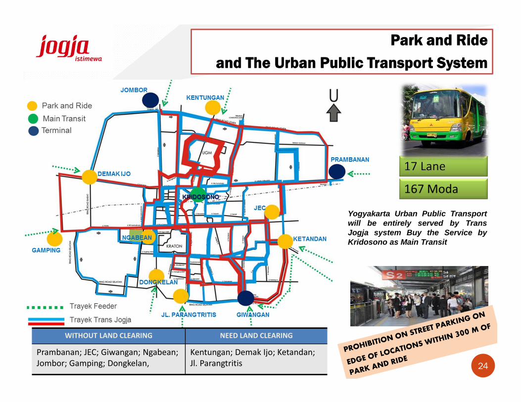
17 Lane
167 Moda
Yogyakarta Urban Public Transportwill be entirely served by TransJogja system Buy the Service byKridosono as Main Transit
WITHOUT LAND CLEARING NEED LAND CLEARING
Prambanan; JEC; Giwangan; Ngabean; Jombor; Gamping; Dongkelan,
Kentungan; Demak Ijo; Ketandan;Jl. Parangtritis
Park and Ride and The Urban Public Transport System
24

T H A N K Y O U
25
DANKE
MATUR NUWUN
TERIMA KASIH