images of america new orleans city...
TRANSCRIPT


This document was created in two parts. The initial document was prepared in 2008 and has the above
introductions listed. The current piece was compiled using the initial document and added items in 2012.
by Amanda Frentz, City Park Development Associate and Kimberly Jochum.
Details taken from:
Catherine Campanella Images of America New Orleans City Park Acadia Publishing: 2011
Sally and William Reeves History of City Park New Orleans City Park CPIA and Friends of City Park: 2000
And websites listed in descriptions

1900s Pichot Stone Bridge
1902
29°59.091N 90°
05.980W
Dedicated in the mem-
ory of Henrietta M.
Leonie Pichot for her
gift of $192.00 to the
Park in 1901.
Langles Bridge
1902
29°59.086N 90°05.721W
Dedicated in the mem-
ory of Angele M. Langles
for her gift of $650.00 to
the Park.
Historical note: Angele
and her mother died on
the morning of July 4,
1898 when the French
Steam Boat, the La Bour-
gogne, sank after collid-
ing with a British ship in
the North Atlantic.
A third stone bridge from around
1902 leads to Goldfish Island. It is
unmarked and is just across Bayou
Metairie from the Peristyle.

1910s Fritz Jahncke Fountain
Plaque
1912
29°59.169 N 90°05.577W
The sons of Fritz Jahncke
donated the fountain in
front of NOMA in 1912. In
1928, Ernest Jahncke added
the statue of ‘Hebe’ into the
fountain. It was replaced in
1972 with ‘Wave’ by Lin
Emery.
Owen/Butler memorial
Fountain Plaques
29°59.042N 90°05.824W
William Frazer Owen, Jr.
—1910
And
Patrick J. Butler—1994
This duel memorial is lo-
cated along City Park
Avenue near N. Hennessy
Street. The original foun-
tain and sculpture,
‘Unfortunate Boot’ was a
memorial to Owen from
his parents. It was re-
placed by the bronze
statue of the water
nymph, ‘Chloe’ in 1929. A
1994 restoration was
dedicated to Butler.

1910s
NOMA Administrators
and Cornerstone
1910
29°59.174N 90°05.599W
NOMA Delgado Lintel
Inscription
1910
29°59.179N 90°05.591W
Monteleone Pillars
1914
29°59.174N 90°05.599W
These two 25-foot marble pylons marking the Esplanade Avenue entrance the Park were erected in memory of
park commissioner Anthony Monteleone. The pillars include 8 bronze lamps and 600 lbs. capstones. The in-
scription appears on the base of both pillars. In 2012, with money given by the Monteleone family, LED lights
were added to each pillar.

1910s Dueling Oak Sign
29°59.091N 90°05.980W
Near the Park’s remaining
Dueling Oak. Thre once were
two Dueling Oaks. One was
lost in 1949. When the oak
was removed, it uprooted a
pair of eyeglasses that were
pronounced by a local
optometrist to be a 100 years
old; two large knives were
also discovered. The remain-
ing one sits near the entrance
to the Bestoff Sculpture
Garden.
This may be one of the last
remaining examples of the
signs, once found throughout
the Park, that were hand
painted by Mrs. Joy Luke.
Thomas Day Bridge
1911
29°59.085N 90°
05.700W
The modernistic
concrete bridge
south of the Casino
Building is a memo-
rial to Thomas Day
who bequeathed
$1500 to the Park in
1910.

Popp Bandstand Inscription
1917
29°59.125N 90°05.741W
An inscription to John F. Popp encircles the
exterior frieze of the rotunda.
Mr. John F. Popp was park visitor with a
penchant for classic style architecture and
music. He was determined to construct
bandstand for the park that was harmoni-
ous with the other newly constructed
buildings. The previous music platform had
been rebuilt several times; the new band-
stand was designed by architect Emile
Weil. On July 4, 1917, Popp’s Bandstand
was dedicated at a wartime festival.
Ribet Memorial Stone
1916
29°59.124N 90°05.731W
This stone marker, in honor of Alexis Ribet, is located at the end of the bell-shapped apron attached to the
bandstand facing the Casino Building.
1910s

Gragard Memorial Plaque
1918
29°59.214 N 90°05.750W
On May 13, 1891, Thomas A.
Gragard was born in New Or-
leans where he lived for the
entirety of his life. Gragard
volunteered for the Marine
Corps in 1917, soon after the
United States entered WWI.
He is reported to have been
cited with decorations for distinguished services
in the operations at Chateau-Thierry wood. He
was killed in action while assisting in an attack
on the town of Bouresches, Aisne, France. This
memorial plaque is located between Victory
Avenue and the sidewalk close to the Botanical
Garden entrance.
1910s
Cox Memorial - 1918 – Stone Plaque
1918
29°59.212N 90°05.734W
This memorial plaque is located between Victory Avenue and the sidewalk close to the Botanical Garden exit.
Other than what is on the plaque, nothing was found on Walter Cox or Wallace Cox.

Brandburn Memorial – Stone Plaque
1918
29°59.147N 90°05.560W
Donald Bradburn fought in the St. Mihiel
and Meuse-Argonne offensives in France. He
died from wounds received in battle on Oc-
tober 21, 1918. This memorial plaque is lo-
cated between Victory Avenue and the side-
walk close to the Botanical Garden entrance.
1910s

1920s
Hyams Fountain and plaques
1921
29°59.215N 90°05.944W
This fountain is just inside of the entrance gate to
the amusement park. Dedicated to the children of
New Orleans by Sara Lauinia Hyams. Ms. Hyams
funded an identical fountain in Audubon Park.

1920s
Dreyfous Bridge Plaque & Cartouche
1924
29°59.135N 90°05.669W
Mr. and Mrs. Felix J. Dreyfous donated the beautiful Dreyfous Avenue Bridge to
City Park, replacing a wooden bridge. This plaque and cartouche are repeated
on the outside railings of the bridge. Mr. Felix J Dreyfous is one of eight original
citizens who nurtured the park during its early years. Dreyfous spend half a
century improving and advocating for City Park. Dreyfous is responsible for
writing the parks original charter, verbiage for a legislative bill for park funding
and distribution, created NOMA board of trustees and served on it.
Anseman Bridge Plaque
1928
29°59.068N 90°05.920W
The plaque on this bridge dedicated to Victor Anseman and the plaque was attached to the former bridge of
the same location and name in 1928. The original bridge was replaced by the WPA in 1938. This is the bridge
that stands today. This bridge crosses Bayou Metaire and has the cement inscription “WPA” and “1938” on
both of its sides. Anseman, known as the “father of City Park”, was the catalyst in the creation of the parks
governing board. He severed as volunteer manager and the first executive committee chairman.
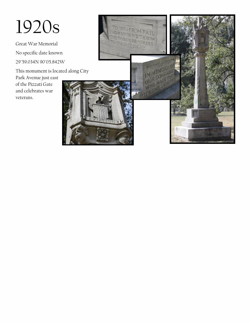
Great War Memorial
No specific date known
29°59.034N 90°05.842W
This monument is located along City
Park Avenue just east
of the Pizzati Gate
and celebrates war
veterans.
1920s

1930s
Popp Fountain and Balustrade Inscriptions
1934
29°59.725N 90°05.917W
Some sources claim in 1924, Rebecca Grant Popp and Isabel
Grant donated $25,000 for a memorial fountain, the money
paid for the fountain as well as several other several other
projects. Other sources say the fountain was meant to be a
memorial to Rebecca and John Popp, her husband who died
in 1918, and was a gift of Rebecca Grant . Rebecca Grant
died in 1928 and entrusted the City Park Board with $25,000 allocated to the memorial. Mrs. Grant requested
the Olmsted Brothers as the designers of the memorial. The central waterspout was designed by Erique Al-
ferez, the head WPA artist.
Tad Gormley WPA Plaque
1935/36
29°59.420N 90°05.030W
Original known as City
Park Stadium, it was re-
named for Tad Gormley
after his death in
1965. Francis Thomas
“Tad” Gormley was ath-
letic direction in City Park
in 1938. Tad Gormley Sta-
dium has hosted various events from a Beatles concert to the Catholic Church communing in Eucharistic Con-
gress. During fall weekends the stadium is full of local football fans watching their favorite high school team.
This plaque is located under the grandstand just inside the Marconi Drive entrance to the stadium.
The above art work by artist Michael Cain, placed on the building in 2005, was inspired by WPA style archi-
tect Enrique Alferez. They are steel, cast glass and neon pieces. There is an inscription reading, “As We Watch
Grace in Motion, Our Spirits Rise Together.” The two pieces represent the athletes and audience celebrating
competition. (http://culturenow.org/entry&permalink=07569&seo=Synergy-of-Sport_Michael--Cain-Arts-Council-of-New-Orleans-and-Percent-for-Art--New-Orleans )

Peristyle Plaques
1. WPA Improvements 1935/36
2. Saia Renovation 1989
29°59.113N 90°05.839W
Architect Paul Andry was responsible for the de-
sign in 1906. The Peristyle was created as a plat-
form for dancing. It was originally called the pa-
ristyleum, and was erected for the price of $15,330
in 1907. The Peristyle was renovated in the 30s as
part of the WPA work and then again in 1989
thanks to the generosity of Mea and Vincent Saia.
It underwent another significant renovation in
2012.
1930s

McFadden Girl Scout Cabin and
WPA Plaque
1936
29°59.255N 90°05.648W
This plaque is embedded in the
pavement near the southwest
entrance to this arts and crafts
style cabin donated to City Park
by William Harding McFadden.
The WPA plaque is mounted on
the northwest exterior wall.
Richard Koch and William S
Wiedorn were the designers of
the cabin blueprints, which were
used to build it during the WPA
improvement to City Park.
FDR Mall Eagle Posts
1936-1937
Various places along Roosevelt Mall
Built by the WPA, 6 of these posts line Roosevelt Mall.
1930s

1930s
Grandjean Bridge Plaque
1938
29°59.225N 90°05.650W
This bridge, which crosses the bayou behind
NOMA, is a memorial to former Park Commis-
sioner, George H. Grandjean. Grandjean was
the designer of the original lagoons. The bridge
also contains the inscriptions “WPA” and
“1938” on each side. It is the third bridge at this
location.
The Grandjean Bridge crossed the Bayou behind
the New Orleans Museum of Art. This is the
third bridge at this location. The first was most
likely made of wood and the second concrete or
iron. The WPA constructed bridge has not
needed any reconstruction since its creation
over 70 years ago. George H Grandjean was a
civil engineer and was responsible for creating
an improvement plan for the park in 1894.
Couturie Forest Plaque
1938
30°00.133N 90°05.575W
This plaque is located just north of Harrison
Avenue Circle on the edge of the Couturie Forest
and Arboretum.

1940s
Montreuil Memorial Bridge Plaque
1949
29°59.353N 90°05.249W
This plaque was mounted on the right-hand, park facing guard rail of the Montreuil Bridge where it crossed
Bayou St. John. The plaque has been removed.
Marcel Montreuil was park manager from 1934-1950 and a park commissioner from 1925-1950.
1950s Montreuil Camellia Gar-
den Stone
1952
29°59.136N 90°05.638W
Marcel Montreuil was
park manager for 16
years. In 1952, the Men’s
Club established this
Camellia Garden in his
memory. Originally con-
taining nearly 150 camel-
lia shrubs, most have
been relocated to make
room for the sculpture
garden. The stone sits
directly in front of the
remaining Dueling Oak
on Dueling Oaks Drive
near Dreyfous Avenue.

Storyland Plaque
1956
29°59.211N 90°05.862W
Dedication of Storyland to the Children of New
Orleans in memory of Mr. and Mrs John W. Batt.
Fort St. John (Spanish Fort)
1959
29°59.586N 90°05.905W
Fort St. John, located on Bayou St. John near the
intersection of Jay Street and Beauregard Avenue
near the Lakefront, is more commonly known as
Spanish Fort. In addition to its history as fortifi-
cation, it was also the site of a very popular
amusement park and resort, of the same name, in
the 1800s. It closed down after the city extended
the shoreline and Pontchartrain Beach became
popular. Some of the carved horses from the
Spanish Fort carousel are now believed to be
among the ‘Flying Horses’ on the City Park car-
ousel since they were both Murphy platforms.
The fort has been under the protection of City
Park since 1934.
1950s

1960s
Walter Jahncke Fountain Plaque
1961
29°59.151N 90°05.727W
This contemporary fountain just across
from the Casino Building was donated by
the family of Walter Jahncke in 1961. It
originally had colored lights that
changed with the spray patterns and was
similar to a fountain on the Jahncke
estate in St. Tammany.
Bacher Sundial Plaque
1963
29°59.106N 90°05.706W
The Bacher Sundial was donated to
the Park by the family of City Park
board member, Albert F. Bacher in
1963. The Plaque is missing.
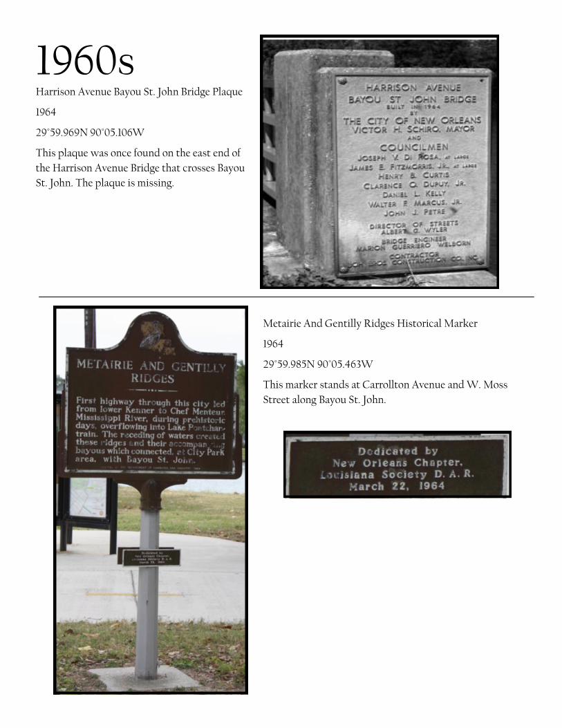
Harrison Avenue Bayou St. John Bridge Plaque
1964
29°59.969N 90°05.106W
This plaque was once found on the east end of
the Harrison Avenue Bridge that crosses Bayou
St. John. The plaque is missing.
1960s
Metairie And Gentilly Ridges Historical Marker
1964
29°59.985N 90°05.463W
This marker stands at Carrollton Avenue and W. Moss
Street along Bayou St. John.

1960s
Wisner Tennis Center Cornerstone
1968
29°59.189N 90°05.894W
The Tennis Center was demolished in
2008 in the aftermath of Hurricane
Katrina.
Schoen Fountain Plaque
1968
30°00.686N 90°05.348W
The Schoen Family contributed the
contemporary fountain in front of the
golf house (Bayou Oaks) on Filmore
Avenue near Wisner Blvd. The foun-
tain commemorated Philip Schoen,
longtime park board member and
gold committee member. The foun-
tain and clubhouse were demolished
in 2008 in the aftermath of Hurricane
Katrina.
1960s

Allard Plantation markers
1968
29°58.990N 90°05.533W
This marker stands at Carrollton Avenue and City
Park Avenue. along Bayou St. John.
1960s

Doctor’s Grove Marker
1974
30°00.735N 90°05.896W
In 1973, the Women’s Auxiliary of Or-
leans Parish Medical Society initiated
plans to establish a Cypress grove be-
tween Filmore Avenue and Robert E
Lee along Marconi Drive. Before Hurri-
cane Katrina, the grove included as
many as 500 trees with name tags of
honored doctors and other deserving
citizens. The plaque is missing.
1970s
Wisner Wing of NOMA
1970/71
29°59.165N 90°05.602W
Stern Auditorium at NOMA
1970/71
29°59.195N 90°05.579W

1970s Colony Grove Marker
1976
29°59.031N 90°05.752W
In 1976 the Daughters of the American Revolution
provided trees that were native to the 13 original
colonies for the establishment of a Bicen-
tennial Memorial Garden near the McDonogh Oak.
There was a tree for each of the 13 colonies. This
plaque sits on City Park Avenue near Solomon Place.
Very few original trees remain.
Engineers Grove Marker
1977
29°59.679N 90°05.800W
The Women’s Auxiliary of the New Orleans Chapter of the Louisiana Engineering Society established Engi-
neers’ Grove in City Park. It was an effort to donate Magnolia trees to the Park in honor of local engineers. The
marker was along Zachary Taylor Drive near Diagonal at the edge of NOLA City Bark. The marker is currently
missing.

1980s Willhoft Plaque
1980
29°59.212N 90°05.800W
This Marian Ruth Will-
hoft memorial plaque lo-
cated on the Rose Garden
gates on Victory Avenue
leading to the reflecting pool and conservatory. It was donated by Ruth’s
daughter, Martha C. M. Willhoft.
Freret Plaque
1982
29°59.215N 90°05.758W
The Douglass Freret plaque is
located on the Rose Garden
gate post closest to the Alferez
Grass Gates on Victory Avenue.
It is donated in the memory of
Douglas Frerets’ wife Ruth Jah-
ncke Freret.
Rotary International
Plaque
1982
29°59.210N 90°05.829W
This plaque is located on
the Rose Garden gates
on Victory Avenue.
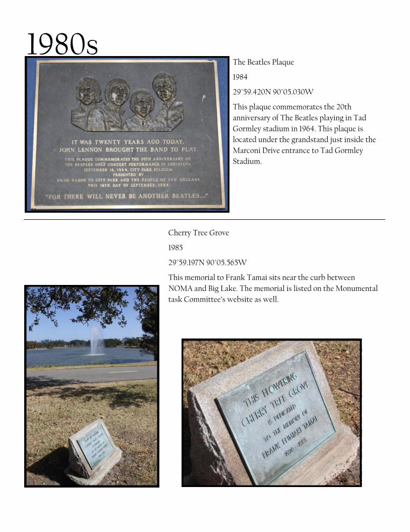
1980s The Beatles Plaque
1984
29°59.420N 90°05.030W
This plaque commemorates the 20th
anniversary of The Beatles playing in Tad
Gormley stadium in 1964. This plaque is
located under the grandstand just inside the
Marconi Drive entrance to Tad Gormley
Stadium.
Cherry Tree Grove
1985
29°59.197N 90°05.565W
This memorial to Frank Tamai sits near the curb between
NOMA and Big Lake. The memorial is listed on the Monumental
task Committee’s website as well.

Lin Emery “Wave”
1988
29°59.174N 90°05.582W
In 1988, Frederick R. Weisman donated the Lin
Emery kinetic sculpture. The piece is in the
fountain in front of NOMA and has multiple
parts that move with the wind.
1980s

1980s Carousel Historic Place Designation
1988
29°59.262N 90°05.931W
The carousel, also know as The Flying
Horses, is the oldest ride in the Park. The
lease for the Carousel has changed hands
several times over the
years. The Carousel itself
dates back to 1906. The
lease and carousel were
sold to the park in the
1980s and the horses were
restored soon after. It is
on the National Register
of Historic Places.

1990s Schoen Centennial Gazebo
(Vixen Hill Gazebo)
1991
29°59.213N 90°05.951W
This gazebo is just to the left-hand side once inside the
entrance of the amusement park. A structure built in
1954 was here before this gazebo was constructed in
1991.

1990s Tad Gormley Gate Restoration
1992
29°59.420N 90°05.040W
This plaque is located on the right gate post at the
Marconi Drive entrance to Tad Gormley.
Tad Gormley Stadium Plaque
1992
29°59.420N 90°05.030W
These plaques are located under the grandstand just
inside the Marconi Drive entrance to Tad Gormley
Stadium.

NOMA Expansion and Renovation Plaque
1993
29°59.209N 90°05.587W
1993 brought the opening on the $23 million expansion and renovation project to NOMA. The scale of the
expansion and renovation, combined with amplified art acquisitions, positioned NOMA into the top 25 % of
the nation’s largest and most important fine art museums.
1990s
Pavilion of the Two Sisters Plaque
1994
29°59.221N 90°05.728W

1990s
John Scott—”Spirit Gates”
1994
29°59.168N 90°05.617W
The gates are located on the left side of the building.
Lark in the Park Gazebo
1995
29°59.221N 90°05.724W
This gazebo is located near the entrance
to the Pavilion of the two Sisters and the
Botanical Garden Gift Shop. It was paid
for from funds raised from the 1995 Lark
in the Park.

Zemurray Azalea and Camellia Garden Plaque
1996
29°59.227N 90°05.716W
This plaque is located on the right-hand side of
the Pavilion of the Two Sisters.
1990s
The Flute Player Plaque
1995
29°59.239N 90°05.706W
This plaque is located at the base of the fountain inside the
Botanical Garden.

1990s
Fletcher Plaque
1999
29°59.070N 90°05.410W
This memorial to Dr. Bobby H. Fletcher
sits adjacent to the Big Lake Pump
House.
Pierre Gustave Toutant Beauregard Statue Plaque
1999
29°59.039N 90°05.396W
The plaque is mounted on
the southwest side of the
Beauregard statue. The
plaque recognizes that the
statue has been added to the
National Register of His-
toric Places in 1999.
The General Beauregard
Equestrian Statue, standing within a circular plot situated at the foot of Esplanade Avenue between Bayou St.
John and the entrance to New Orleans City Park, was built in stages, with the base being dedicated on May
28, 1913 and the statue on November 11, 1915. Alexander Boyle's bronze statue depicts the Confederate General
P. G. T. Beauregard astride a prancing horse. The entire ensemble stands a total of 27 feet in height. The dark
gray granite base is 10 feet tall, rising from a one-foot foundation. The statue is 16 feet tall. (http://www.flickr.com/
photos/wallyg/2498059653/ )

2000s Timken Center Plaque
2000
29°59.132N 90°05.703W
The Timken Center is
commonly known as
the Casino Building. It
houses the Parkview
Café, public bathrooms,
and a gift shop. Park-
view Terrace is upstairs
and is a popular
event space.
Pizzati Gate Rededication
Plaque
2001
29°59.029N 90°05.887W
Originally called the Alexander
Street entrance, the gate is
located at City Park Avenue and
Anseman Avenue. Steamboat
Captain Salvadore Pizzati
donated the archway in 1910.
The structure also includes the
inscriptions: ‘Erected A.D. 1910’
and ‘Donated by Capt. S.
Pizzati’. The Gate was
rededicated in 2001 in memory
of Edgar Luminais.

Blue Star Memorial By-Way plaque
2002
29°59.330N 90°05.763W
The plaque is located by the flag pole on the
neutral ground along Roosevelt Mall. It was
donated by the Federated Council of New
Orleans Garden Club on April 26, 2002. Of
the 14 Blue Star Memorial ‘Highway’ Mark-
ers in the Metro area, there are only 2 ‘By-
Way-’ markers. The other Blue Star Memo-
rial is located in Lafreniere Park.
Colombier de Carol Plaque
2005
29°59.105N 90°05.673W
Known as the City Park Pi-
geonierre, it was designed by
Felix Dreyfous and given to the
park in 1928. It is located on Pi-
geon Island near the Casino
Building. It was refurbished and
the plaque was placed in 2005,
shortly before Hurricane Katrina.
2000s

Rotary Club Plaque
2006-2007
29°59.146N 90°05.558W
This plaque recognizes the con-
tributions that Rotary Clubs
made towards the improve-
ments to Lelong Avenue after
Hurricane Katrina. These im-
provements included new trees,
benches and sidewalk repairs.
There is an identical plaque
placed just across Lelong Ave-
nue on the Big Lake side of the
street.
Amusement Park Renovation Plaque
2007
29°59.212N 90°05.933W
This marker is located just inside the entrance
to the amusement park. Renovations were
made after damage from Hurricane Katrina
and the Federal flood.
2000s

Pan American Stadium Plaque
2008
29°59.629N 90°05.223W
This plaque is located just inside the entrance gate.
Stanley Ray Playground Arch
2008
29°59.135N 90°05.782W
The Stanley Ray Trust made a gift
of $250,000 toward the park’s
endowment to maintain the large
playground along Dreyfous Avenue.
They playground is now named the
Stanley Ray Playground. A new
arch designating the Stanley Ray
Playground was erected in
February, 2008.
2000s
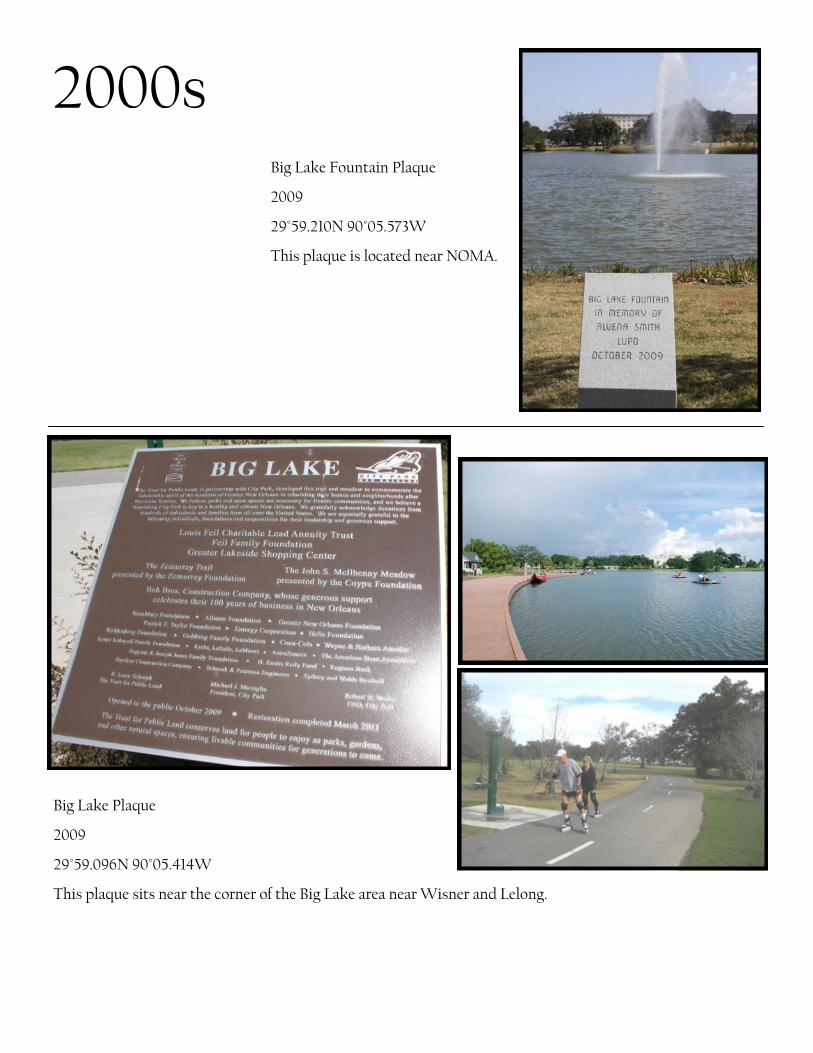
Big Lake Fountain Plaque
2009
29°59.210N 90°05.573W
This plaque is located near NOMA.
2000s
Big Lake Plaque
2009
29°59.096N 90°05.414W
This plaque sits near the corner of the Big Lake area near Wisner and Lelong.

Laborde Pump House Marker
2009
29°59.166N 90°05.392W
This stone marker names the Big
Lake Pump House in memory of
Margaret Bienvenu Laborde.
2000s
Grateful Labors Plaque
2009
29°59.130N 90°05.505W

Singing Oak Plaque
29°59.151N 90°05.409W
This plaque is located under-
neath the Trust For Public
Land oak, also referred to as
the Singing Oak. The artist,
Jim Hart, used aluminum alloy
and tuned the wind chimes to
the Pentatonic scale. One
chime is 14 feet long.
2000s

2010s Rotary Soccer Field and Softball Diamond Plaque
2010
29°59.586N 90°05.905W
This plaque is located in the lobby of the Administration
Building.
Administration Building Plaque
2010
29°59.588N 90°05.905W
This plaque is on the left-hand wall on the
front patio of the building. This site was also
the site of the previous Administration build-
ing destroyed in Hurricane Katirina.

2010s NOLA City Bark Arch
2010
29°58.991N 90°05.534W
This arch is above the main
entrance to the Dog Park.
Goldring-Woldenberg Great Lawn
Plaque
2010
29°59.124N 90°05.832W
This plaque is at the Dreyfous side
of the Great Lawn.

2010s Mercedes-Benz Plaque
2010
29°59.593N 90°05.911W
This plaque is located near the Administration Building.
City Park/Pepsi Tennis Center Plaque
2011
29°59.586N 90°05.905W
This plaque is located on the left-hand side of the main entrance.

Arbor Room Plaque
2011
29°59.586N 90°05.905W
This plaque is located on the wall nearest
Popp Fountain.
2010s