identifying the trunk roads of early modern england …identifying the trunk roads of early modern...
TRANSCRIPT
Identifying the Trunk Roads of Early Modern
England and Wales
Max Satchell
Preliminary Draft, May 2017
Hitherto studies of the road transport network in Early Modern England and Wales and its
relationship to economic and demographic change in this period have suffered from a lack of
clear information concerning the geography of the network of what can be termed main,
primary, or trunk roads - the main routes of the road network which connected cities, ports
and large towns, and, as such, would have been likely to develop road passenger and carrying
services early. This lack of information primarily reflects the problematic nature of surviving
documentary and cartographic sources, and also the difficulty hitherto, of integrating the very
substantial amounts of geographical information within this material in an effective analytical
framework.
This paper begins with a discussion of the late seventeenth century road network in general
and the distinction between main and other roads. Focus then moves on the need to reassess
the status of the c.7500 miles of road presented in strip map form in the earliest road atlas of
England and Wales - John Ogilby's Britannia published in 1675. Ogilby termed these
"principal roads" and most commentators have assumed these were primary roads but as will
be shown this is less than certain than might be thought. To assess the degree to which Ogilby
mapped the main roads of England and Wales and how much of the network might be
missing the location of Ogilby roads are then compared using GIS software with other
sources indicative of road travel from the late sixteenth century to c. 1730: places with
accommodation for travellers apparent from substantial numbers of spare beds and stables as
recorded in a national military billeting survey of 1686; abodes of petty traders given in a
register of their licences 1697-8, places with scheduled road services from London 1637-
1730; early turnpike roads 1663-1730, routes indicated in early road books 1571 and 1679,
and postal routes and post offices 1675-1682. The paper concludes with an assessment of the
degree to which Ogilby's routes actually did represent trunk roads and how those parts of
network Ogilby missed may be identified and mapped.
The Road Network of England and Wales in the late Seventeenth Century
The road network of England and Wales in the late seventeenth century was very extensive.
Travel either on foot or horseback was possible, though not necessarily easy, virtually
everywhere. A dense network of roads and tracks many of them very old extended the length
and breadth of the country. Between the numerous market towns roads narrow but passable
for wheeled vehicles were common in lowland areas. Even in extreme terrain in parts of the
Pennines "horse causeys" - packhorse tracks - existed. The would-be traveller would find
most rivers crossed by bridges or fords at reasonably close intervals. On estuarine rivers
where bridges were not practicable ferries were available at some perhaps most key
crossings.
Only in areas of wetland are the account of roads which were only practical for use in the
summer. Grafton, for example, in giving details of an alternative route from Exeter to Bristol
via the Somerset levels state that "no man can travel it except ... in summer or a in a great
frost". But more circuitous alternative routes seems to have usually existed - that between
Exeter and Bristol, for example was of long-standing and well known and was estimated by
Grafton to be five customary miles longer. Travel in winter took longer and cost more but
seems to have been practicable. Certainly there are no examples in the secondary literature of
communities who were wholly cut off in winter because of the impassability of the road
network. Many roads were of course primarily of local importance. In arable areas, especially
areas of ancient enclosure, local tracks were needed to bring plough to field, to move
livestock from one fallow field to another, to bring seed corn for sowing, to move the harvest.
The extensive nature of the road network of England and Wales creates conceptual
challenges for the would-be geographer trying to delineate and understand it. With so large a
network and the existence of a myriad of roads and tracks between places is appropriate to
think that there were particular routes favoured above others between important centres at
all? The intellectual concept of the main road is a nebulous one in the early modern period
and has not received the attention from historians it deserves. Certainly Ogilby, Blome, Defoe
and their contemporaries distinguished between major roads and other in their texts by the
use of the phrases like "the great road" or "the great way" and as will be seen the evidence for
travel and the facilities for travellers were differentially focussed on some routes rather than
others.
The Ogilby Atlas
Ogilby's atlas is rightly celebrated in the history of cartography. The national road network is
hardly depicted at all, and certainly not with any accuracy, until Ogilby published his atlas of
"principal roads" of England and Wales in 1675.1 Britannia consisted of strip maps at
1:63360 scale of 85 routes on 100 copper plates which surveyed and mapped over 7500 miles
of road. Earlier itineraries and road books had demarcated routes nationally but only as
sequences of stages usually eight to twenty miles apart. In essence Britannia marked the
transition from route, a direction of travel between known points, to a road, a physical feature
in the landscape. Despite the significance of Ogilby, his atlas has remained largely the
preserve of the cartographic historian. Hitherto analyses of the relationship between the road
network and parish-level data using itineraries and road books has been impracticable
because of the line of the road between the stages is usually uncertain. The Ogilby GIS makes
1 The earliest printed maps to show roads are maps of Hertfordshire and Middlesex by Norden published in
1593 and 1598 respectively. The earliest national map with some roads on it engraved by Hollar in 1667 and
published by Place in 1668: Shirley, Printed maps of the British Isles, pp. 68, 115
such an exercise practicable for the late seventeenth century and perhaps earlier as the road
network appears to have changed little after 1300.2
The status of the Ogilby roads is not entirely straightforward. Some commentators have
regarded them simply as main roads.3 More recently Shirley, Delano-Smith and others have
emphasised the importance of Ogilby and post roads. In its most confused this view claims
Ogilby only mapped post roads and his depiction of post-roads has been criticised for
containing errors and being incomplete.4. To be clear Ogilby includes a list of post roads in
the preface of Britannia and set out to map the six great post roads. Nowhere in the volume
does he claim to be mapping by-post roads as well.
At the same time doubts have been raised concerning the degree to which Britannia was
actually used to aid road travel. Its size, weight, expense and its unfamiliar cartographic
innovations have been said to make it impractical for travel either at the planning stage or
once the journey had begun. Others have simply styled Ogilby as a mixture of post roads and
“all those other roads groaning under the weight of heavy wagons laden with goods for sale”
which ignores the possibility he mapped routes only traversable by horses.5 Given the
questions hanging over Ogilby’s work discussion must first focus on what the roads mapped
actually represent.
The view that Britannia simply consists of main roads would seem to be borne out by what
Ogilby himself wrote. He claimed the roads included in his atlas represented 'the most
considerable' of some 26,700 miles of roads that had been surveyed. However, the situation
2 D. Harrison, The Bridges of Medieval England (OUP, 2004); M. Satchell, 'Continuity or change? The road
network of England and Wales c. 1370-1675, forthcoming 3 F.V. Emery, 'England c. 1600' in H. Darby ed. A New Historical Geography of England (CUP, 1973), 248-
301; Harrison, ibid. 4 C. Delano-Smith, 'Milieus of Mobility' in Cartographies of Travel and Imagination, ed. J. R. Akerman
(London, 2006), pp. 16-96: 51; D. Blair, ‘Scott, Cartography and the Appropriation of Scottish Place’ in
Literature and Place 1800-2000, ed. P. Brown and M. Irwin (Bern, edn 2008), 87-108: p. 90; M. Hvattum,
Roads, routes and landscapes (Farnham, 2011), p. 35; J. Langton, ‘South, North and Nation: Regional
Differences and Consciousness in an Integrating Realm, 1550-1750’ in Geographies of England. The North-
South Divide, Material and Imagined (Cambridge, 2004), pp. 112-144: 136 5 K. Dierks, In My Power Letter Writings and Communications in Early America (Philadelphia, 2009), p. 29.
that led to the production of Britannia in the first place must be borne in mind. Ogilby's
original aim was to produce a six volume series with four volumes of county maps and
descriptions, one volume of principal roads - Britannia, and a volume on London. Lack of
money meant the scheme failed with Britannia being one of the few outputs. The whole
scheme was knitted together with a series of surveyed road traverses designed to form the
framework by which local surveys could subsequently fill in the detail for the county maps.
In short some roads were surveyed not because of their economic importance but because by
surveying them the county maps would be laid out more accurately. It is clear that Ogilby
decided to include some of the resultant "extremity roads" in Britannia. This is explicit when
Ogilby qualifies his statement concerning his selection of the "most considerable roads" with
the comment "...or such that an orderly distribution of the kingdom has obliged us to exhibit".
In short there may be roads in Britannia or at least sections of them which were put in for
reasons that had nothing to do with traffic.6
Some of these roads seem extreme but a cursory examination of Britannia suggests in most
examples it was probably only short sections that were little used . For example the road from
London to the westward extremity of Cornwall at Land's End may seem unrelated to traffic
but as far west as Marazion was the post road from London, and even west of here the section
which lacks evidence of travel extends for only 10 miles beyond Penzance, which had a
substantial provision for travellers in terms of beds and stables in 1686. However, only with
systematic analysis can this be established.
There are also doubts concerning the capacity of Ogilby to select the principal roads in the
first place. Ogilby's varied career as dancing-master, courtier, and theatre owner (c. 1620 -
1641); poet and translator from 1649; and, only from about 1669, compiler of geographical
works and atlases, appointment as Royal Cosmographer in 1671 culminating in the project
6 Ogilby, preface

that resulted in Britannia is well known.7 Given the novelty of what he was doing, nothing in
his background gives us much confidence that he was equipped to select the main roads of
England and Wales.
However, without systematic analysis it is easy to misunderstand routes in Britannia. For
example, the inclusion by Ogilby of the entire medieval pilgrimage route to Walsingham
Priory - a staple of medieval itineraries and early road books - as part of the route to Wells
seems an obvious anachronism but the by-post road from Larling to Wells had the same
succession of stages north from Hilborough. However, it is only with a systematic analysis of
the spatial relationship between Ogilby and the indicators of traffic outlined above that this
type of problem can be properly assessed.
Figure 1. Legend from Moll's map of England and Wales 1710
A more fundamental problem was that Britannia as published had half the number of plates
as planned which meant that a substantial number of the roads intended for the atlas had to be
7 Oxford New DNB
omitted.8 Certainly there was a contemporary realisation that Britannia had omitted some
important roads. As early as 1710 the map-maker Hermann Moll included "Roads not to be
found in Mr Ogilby's Book" as a distinct category identifiable by its own type of line work in
his single sheet map of map of England and Wales (see figure 1).9
Also the structure and marketing of the book also imposed limitations. The commitment of
the book to map the 6 great post roads which because of their length occupied 17 of the plates
constrained the amount of space available for other routes. Indeed of the 100 plates that make
up Britannia, 54 of them map roads which lead to London either directly - Ogilby classified
these as "Direct Independants" , or branch from the said Direct Independents.10
While
probably reflecting the economic realities of the day, the London-centric nature of Britannia
meant that routes between other centres were not included as comprehensively. Indeed
Chartres has claimed that Ogilby neglected important cross roads because his focus was
primarily on London's links to the provinces and routes between old provincial centres.11
Again comparison between Ogilby and other data can explore this claim.
The Ogilby GIS
Assessing the degree to which Ogilby mapped the network of main roads is now practicable
due to the creation of a digital reconstruction of the roads mapped in Britannia. Identifying
then digitising the roads depicted on each section of strip map has proved to be no easy task.
Each strip map in Britannia was the product of a surveyed road traverse with distances
accurately measured by a perambulator and shown on the maps in miles and furlongs..
Dickinson has shown that while many of the Ogilby maps suffer serious distortions in shape
8 Ogilby claimed that he had originally aimed to survey 40,000 miles of roads but when Britannia was published
only two-thirds of this had been walked over. This provides an upper bound of 26,600 miles. The original
number of plates in the atlas was 200. The 100 plates published comprised c.7500 miles of roads which if the
layout and scale were the same would give a total length to be surveyed as 15000 miles 99
R.W. Shirley, Printed Maps of the British Isles 1650-1750 (London, 1988), 89 10
Ogilby, preface 11
Chartres, 'The Eighteenth Century English Inn', 208
due to the engravers of the Atlas poor rendering of the survey information, the maps are far
more accurate in terms of distance and that this characteristic used in conjunction with
retrogressive analysis of later cartographic sources makes it possible to reconstruct their
course.12
The only national attempt to place the roads shown on Ogilby's maps onto a modern
projection is A Map of XVII Century England (Ordnance Survey, Southampton, 1930) which
depicts the roads mapped by Ogilby with each road being referenced by its plate number. The
map was produced by the cartographer and archaeologist, O.G.S. Crawford. Hitherto its value
has been largely overlooked with the exception of Roberts.13
In 2012 comparison between
Ogilby routes in Cambridgeshire as mapped by Crawford and digitised anew by Satchell
from Britannia and other sources confirmed the general accuracy of Crawford's work. A
initial GIS of Ogilby was then digitised from geo-rectified scans of A Map of XVII Century
England which were then checked for completeness against Britannia and a handful of
omissions added (see Fig 1.).
The 1:1,000,000 scale of the Crawford map meant that the polylines digitised might be up to
1km out of alignment.14
This degree of inaccuracy is too great for some sorts of spatial
analysis so in 2014 a more accurate version of Ogilby was begun using the Crawford derived
GIS as a guide. This was made practicable by generous funding from the NSF and the
Leverhulme Trust, and access to the work of others scholars who had invested thousands of
hours in working on particular sections of Ogilby. The GIS that resulted would not have
12
G.C. Dickinson (2003), 'Britain's first road maps: The strip-maps of John Ogilby's Britannia, 1675',
Landscapes, 1 (2003), pp. 79-98 13
B.K. Roberts, 'Woods, fens and roads: Where are the fens?' in Through Wet and Dry: Essays in Honour of
David Hall, ed. T. Lane and J. Coles, Sleaford and Exeter: Lincolnshire Archaeology and Heritage Report Series
No 5 and WARP Occasional Paper 17 (2002), pp. 78-86 14
M. Satchell, 'Ogilby Summer Digitisation Report', Unpublished Report, September 2014.
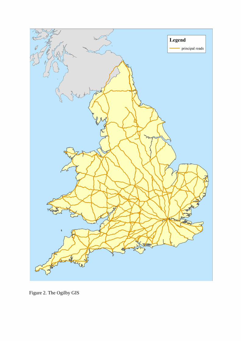
Figure 2. The Ogilby GIS
been access without permission to use unpublished marked up paper maps by Gordon
Dickinson (4,700 miles England and Wales), and Derek Bissell (Wales and the borders),
maps in the doctoral thesis of Andrew Jones (Yorkshire) and data from online resources
created by Jean and Martin Norgate (Hampshire). The Dickinson section of the GIS was
processed with the able assistance of Spike Gibbs who scanned 5303 pages of maps and notes
kindly lent by Gordon, rectified the paper maps and digitised sections of the road network
that amounted to some 4700 miles in total.15
Comparing Ogilby with other sources indicative of road travel
This section compares the location of Ogilby roads using the GIS with other sources
indicative of roads and the settlements they connected from the late sixteenth century to
1730. These sources can be classified in terms of type and spatial extent. Most of the datasets
relate to settlements and give information related to different levels of transport provision.
There are also evidence for roads and routes which may represent important omissions of
main roads from Britannia in three sources: early turnpike roads 1663-1730, early road books
1571 and 1679 and post roads 1675-1682. In terms of their geography these sources are
divisible into three groups: sources which are national in scope, sources which are London-
centric i.e. they focus on London roads or London road services, and sources which are in
between
Settlements
There are two principal national sources for settlements with transport data roughly
contemporary with Britannia. The first is a listing of settlements with the numbers of spare
15
M. Satchell, The principal roads of England Wales, 1675, shapefile (Cambridge, 2017);
http://www.geog.port.ac.uk/webmap/hantsmap/hantsmap/ogyanal/ogyanalf.htm (consulted 11 05 2012); A.K.
Jones, 'The maps of Yorkshire printed in the period 1577-1857 as sources of topographical information',
unpublished Ph.D, University of Leeds, 1981;
beds and stables recorded in a billeting survey of 1686. The second is a list of petty traders
licences which indicates the settlements where they were ostensibly resident in 1697-8.
The Spare Beds and Stabling Survey
The survey was devised by William Blathwayt, Secretary at War, to find out where troops
might be billeted.16
Blathwayt was an innovative and talented administrator who had single-
handedly set up the War Office. The survey seems to have been well managed and conducted
with considerable rigour.17
It included inns, taverns, alehouses and coffeehouses and,. since
all four types of public house required a licence to trade, the machinery of local government
was well placed to help with survey. Also since inns, taverns, alehouses and coffeehouses
were compelled to receive soldiers or lose their licences it is probable that their owners were
compliant.18
Details about how the survey was conducted are scanty, but it seems that
information were gathered regionally in association with the justices of the peace which were
then collated usually at county level and forwarded as a series of individual documents which
were then entered county by county in alphabetical order into the volume entitled 'Abstract of
a particular account all Inns, Alehouses etc in England with their stable rooms and bedding in
the year 1686.19
The beds and stabling survey have been used in numerous regional and local studies in the
past but not at a national scale presumably to sheer size of the dataset which consists of
11,025 records of the numbers of beds and stables of cities, towns, villages and hamlets.20
For
16
G. Jacobsen, William Blathwayt, a late seventeenth century administrator (1932), p. 416; Calendar of
Treasury Books, Volume 8, 1685-1689 17
The survey includes annotations by Blathwayt on several of its 218 folios: ibid . The section for Chester,
which is unusally disaggregated is suggestive of the rigour of the survey. Sixteen different returns for Chester
show major concentrations of travellers' accomodation across the city including Eastgate, Northgate, and Bridge
street: TNA, WO 30/48, ff. 21v-22v, 25r, 26r, 27v 18
S. Johnson, Notes upon the Phoenix edition of the Pastoral Letter , 1 (1694), pp. 82-3; S. Pincus, 1688: The
First Modern Revolution (2005), p. 145 19
TNA, WO 30/48. The survey was transcribed by Jacob Field in 2014. 20
D.L. Powell, 'Billeting in Surrey in the Seventeenth and Eighteenth centuries', Surrey Archaeological
Collections, 27 (1914), 128-135; M. Frearson, 'The Mobility and Descent of Dissenters in the Chiltern
Hundreds', in M. Spufford, The World of Rural Dissenters (Cambridge, 1995), pp. 273-87; P. Riden, 'Guest beds
and stabling in Derbyshire 1686-1756', Derbyshire Archaeological Journal, 128 (2008), pp. 65-98
the purposes of this paper spare stables rather than spare beds or some combination of the two
have been regarded as the primary indicator of traffic. While beds are a better indicator of
passenger traffic, they are no guide to freight traffic, but stables are a good indicator of both
passenger and freight traffic. To be useful as an indicator of traffic a threshold had to be set
for the number of spare stables. Initially some 7552 settlements were disregarded because
they had five stables or less. This included 1838 places listed as having no spare beds or
stables.21
On further consideration the threshold was raised to 14 spare stables as this number
reasonably well represented the number of horses in a single pack horse gang engaged in
long-distance travel in this period.22
Settlements with 14 or more spare stables represented c.
80% of the 148184 stables recorded in the survey.
The next task was to geo-locate the settlements. It is difficult to identify a surprisingly high
proportion of the places in the abstract due to the relatively poor rendering of the place-
names. Problems of identification also reflect the presence of two sequences under each letter
of the alphabet the second of which consists of extremely minor places some of which may
even have been been buildings. Work on the Derbyshire section of the volume, for example,
could not identify 18 % of the entries. However, many of the unidentifiable places had very
small number of stables.23
With a threshold set to 14 or more the problem of identifying
places largely disappears. Of the settlements with 14 or more spare stables it was possible to
identify and geo-locate 842 of them and it these that will be discussed in the next section of
the paper.24
21
The null returns are mostly found in a second sequence in a different hand and ink under each letter: 22
Gerhold, Carriers and Coach Masters, p. 61. My thanks to Alan Rosevear for advice on the stabing threshold. 23
P. Riden, 'Guest beds and stabling in Derbyshire 1686-1756', Derbyshire Archaeological Journal, 128 (2008),
pp. 65-98 24
M. Satchell, J. Field, and A. Rosevear, 'Billeting Survey of the Spare Beds and Stables 1686, shapefile
(Cambridge, 2017). Jacob Field made a trial GIS in 2014. This has since been upgraded and refined by Max
Satchell with help from Alan Rosvear.
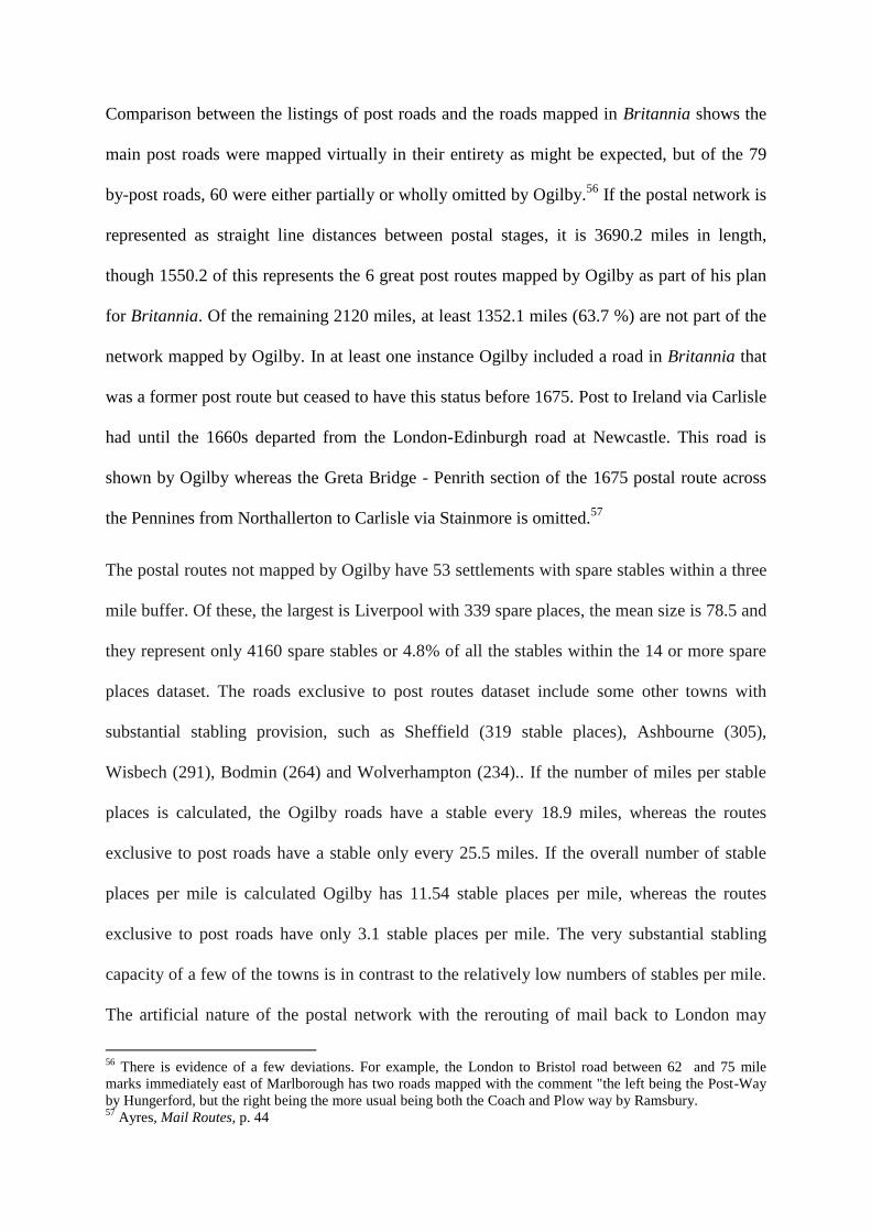
Ogilby roads and the distribution of spare stables
The 842 settlements with 14 or more stables represent in total 87205 spare stable places with
a mean number of stables per settlement of 103.6. The geo-statistical capabilities of the GIS
software makes it possible to establish the density of beds per square mile. Essentially the
software employs an algorithm to distribute values across the map by averaging across
known points with a pre-determined kernel (radius) size. The kernel used to create figure 3
was set to 30 miles. Of the 842 settlements, 377 of them lay within a mile of an Ogilby road
and their total number of stables represented 74% of all the stable places. Though the
majority of the 842 settlements lay more than a mile from an Ogilby road, the minority that
lay within one mile had a higher than average numbers of stables places. Of the settlements
within a mile of an Ogilby road, the mean number of stables places per settlement was 171.
Moreover if the 842 settlements are ranked into quartiles in terms of their numbers of stables
73% of the highest quartile lies within a mile of an Ogilby road. This suggests that Ogilby
mapped roads that were more travelled in that they connected settlements with a greater
provision of inns. The number of miles of Ogilby road per settlement with 14 or more stables
within the one mile buffer was 19.9. This statistic is of value because it can be compared with
the distribution of stables of non-Ogilby roads.
The value of this dataset as an indicator of road transport is also apparent when the twenty
places with the greatest number of spare stables are compared against the twenty largest
places in the urban hierarchy c.1670.25
Only eight of the places are also among the twenty
most populated urban settlements, though doubtless London would be in the top 20 places
with spare beds too, if it had not been omitted from the billeting survey. It is notable that
some places with very substantial number of spare stables, though only small towns,
occupied key nodal positions on the road network, such as Windsor, Henley and Andover
25
Wrigley, Urban Growth and Agricultural Change, table 7.1

(see table 1).26
In essence what we are seeing is not a simple relationship between the size of
the urban centre and the number of stable places, but a dataset that represents the distribution
of horses used for travel.
Name
Top 20 places in
terms of the number
of spare stables
Place in hierarchy of
20 urban centres c.
1670
St Albans 1411 -
Bristol 1377 3
Leicester 1143 -
Cambridge 1137 19
Warwick 1077 -
Winchester 1048 -
Exeter 1037 7
Norwich 930 2
Lincoln 894 -
Newcastle upon Tyne 894 5
Salisbury 865 -
Kings Lynn 832 14
York 800 4
Gloucester 759 -
Nottingham 686 -
Windsor 669 -
Henley 659 -
Ipswich 630 =
Wells 599 -
Andover 582 -
Table 1 Settlements with the most stables and their rank in the urban heirachy
26
Hearth tax data provide population estimates of 1802 people for Andover and 1173 for Windsor: Clark et al,
Population Estimates of English Small Towns, pp. 3, 65
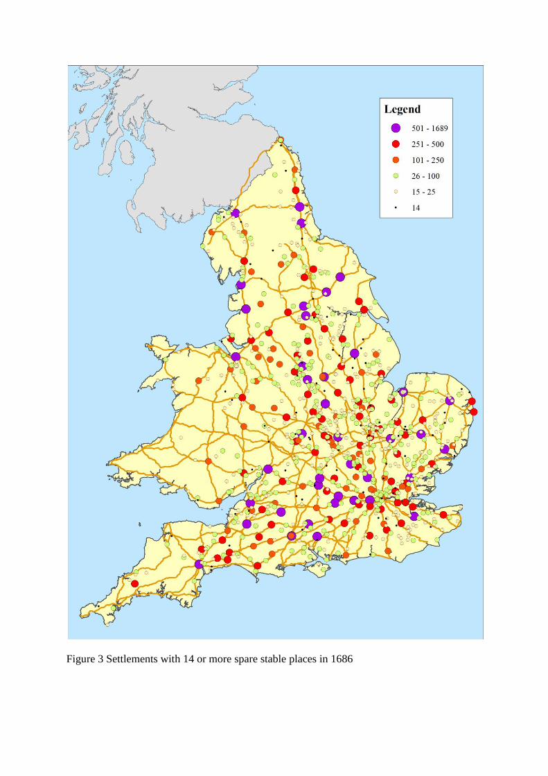
Figure 3 Settlements with 14 or more spare stable places in 1686
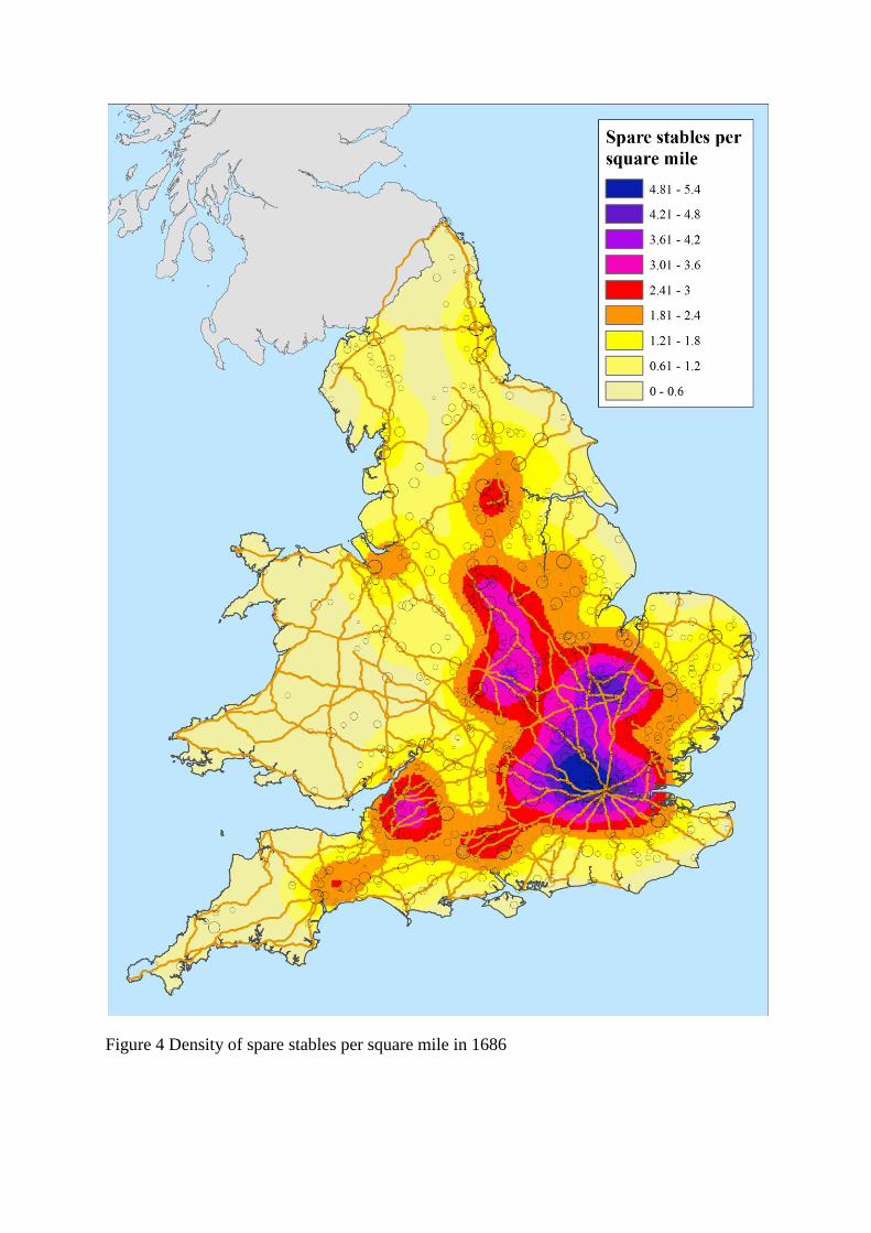
Figure 4 Density of spare stables per square mile in 1686
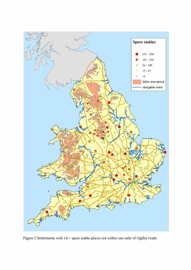
Figure 5 Settlements with 14 + spare stable places not within one mile of Ogilby roads
While the strong relationship between the stables and Ogilby suggests what he mapped were
generally important roads, the large number of places with substantial numbers of spare
stables not near Ogilby roads indicates he also omitted important roads (see figure X). The
largest (200 places plus) include the ports of Liverpool, Lowestoft, and Wisbech, Wirksworth
a major lead mining centre largely served by packhorses, and important transhipment points
on major navigable rivers at Gainsborough on the Trent, Bewdley on the Severn and Windsor
on the Thames, which was also important for the movement of passengers by road to London
and by water to London and Gravesend.27
The number of settlements not within a mile of an
Ogilby roads with 100 or more spare beds was only 24. Settlements like these and many
others that had a smaller number of spare stables can be regarded as being served by main
roads, though secondary roads could of course have inns too. Even a cursory examination of
the data in mapped form shows that whereas settlements with 25 stables places or less were to
be found virtually everywhere, places with larger numbers of stables were geographically
more circumscribed being virtually absent in Wales, upland areas virtually everywhere, and
large sections of eastern England north of Suffolk. This absence is no really explicable due to
the density of the Ogilby road network except perhaps for Devon and Wiltshire. The relative
paucity of many settlements with substantial stabling near many of the navigable rivers such
as the Severn, Tyne, Tees, and the Yorkshire rivers may reflect the far fewer number of
horses needed to move goods by water than land in these areas. The density of settlements
with large numbers of spare stables is particularly striking on the north side of London and on
either side of the Pennines, in Derbyshire, Cheshire and the North Riding. Investigation into
the ratio of beds to stables in these Pennine fringe areas has yet to be done, but if they show
substantially higher ratios of stables to beds they may indicate the use of horses rather than
horse-drawn coaches and wagons to carry passengers and move freight as wheeled transport
27
C. Dodd, 'Thames Watermen, Wherries and Ferries', unpublished paper presented March 13 2017; Gerhold,
Carriers and Coach masters, p. 80.
requires far fewer passengers than freight transport. In the final part of the article approaches
to how these missing roads indicated by the spare stables and the other datasets might be
identified.
Petty traders licences 1697-8
The other national dataset consists of a register of licenses issued to petty traders in 1697-8.28
In
1697 an act made it compulsory that petty traders needed to have a license. A licensing fee of £4
per person plus a further £4 for each horse was required to be paid by "every hawker, pedlar,
petty chapman or any other trading person or persons going from town to town or to other
men's houses and travelling either on foot or with horse, horses or otherwise ... carrying to
sell or exposing to sale any goods, wares or merchandize". Individuals who manufactured
goods but travelled to sell them were specifically exempted from the act. When obtaining a
license petty traders were required to state their place of abode, which is recorded in the
register, and it is these settlements which will be compared against the GIS of Ogilby roads.29
Before doing so three potential problems with the survey must be addressed: first, the degree to
which petty traders are omitted from the survey; second, the accuracy of the "places of abode" which
they gave, and third, the degree to which the act was carried out consistently across England and
Wales. Spufford and others have suggested that many petty traders are omitted from the listing due
to widespread evasion because at £4 per annum the cost of the license was large relative to their
average stock in trade of c. £25 suggested by the probate inventories. That evasion could be a problem
is apparent in the substantial drop in the number of licenses issued the license year after 1697-8.30
However, the act included a substantial financial incentive for people to inform against unlicensed
petty traders. Those petty traders found to be unlicensed had to pay a fine of £12 half of which went to
28
TNA, AO 3/370. This dataset was digitised from a transcript of the register made by the late Margaret
Spufford. It was digitised by Annette McKenzie and geolocated by Alan Rosevear. My thanks to both of them
and to Amy Erickson for facilitating access to the Spufford transcript. 29
10 William 3 c. 27 printed Statutes of the Realm, VII, 266-9 30
Spufford, Great Reclothing of Rural England
the informer. Examples where manufacturers of bone lace carrying their goods to sell to London shops
were wrongly prosecuted suggests that the act was by no means a dead letter.31
So it is by no means
clear that evasion was widespread.
Doubts concerning the places of abode listed derive from Spufford 's work trying to link 193 petty
traders listed in the register for Tetbury, Shrewsbury and Kendal to local sources including marriage
licenses, parish registers and wills.32
The virtual absence of these individuals from these sources is not
necessarily significant. Many petty traders were Scottish and so would be omitted from parish registers
because they were dissenters, also the probable predominance of young single males in this group
meant they were less likely to occur in these sources as well.33
Moreover, it is inherently likely that
there would be a strong relationship between the place given as residence and trade as this was a
general pattern for scheduled road carriers. Gerhold's work on the probate inventories of London
carriers, for example, has shown a strong spatial relationship between places of abode and the
destinations to which they were listed as carrying.34
A further complication is that looseness of terminology in the occupational titles of petty traders may
have meant the act was interpreted in different ways in different places. This is especially the case for
chapmen. For example, Samuel Shore of Sheffield was alternatively termed chapman, ironmonger,
and hardware man 1698-1703, while a wealthy cattle dealer of Starforth (Yorks, North Riding) was
described as a "fair and honest chapman" in 1701-2.35
The wholesale absence of any licenses for the
comparatively well-off iron-carrying chapmen from the vicinity of Attercliffe in the Peak District
documented by David Hey would suggest there licences were thought to be required only for lesser
chapmen. The licenses for 60 chapmen with horses listed under Olney, a major centre of the lace-
31Anon, The Case of the Makers and Wholesale Traders in the Manufacture of English Bone-Lace (London,
1698) 32
Spufford, Great Reclothing of Rural England, pp. 26-31 33
Over 70 of the 134 licensed petty traders at Tetbury had Scottish surnames: ibid, p. 27 34
Gerhold, Carriers and Coachmasters, p. 10 35
Hey, Packmen, 138; North Riding Quarter Sessions, no. 218, pp. 184-5
making region of Bucks/ Northants, suggests a wider definition of chapmen was sometimes adopted.
As a consequence data should be regarded as minima i.e. the absence of license evidence for petty
traders is not necessarily evidence that petty traders were absent.
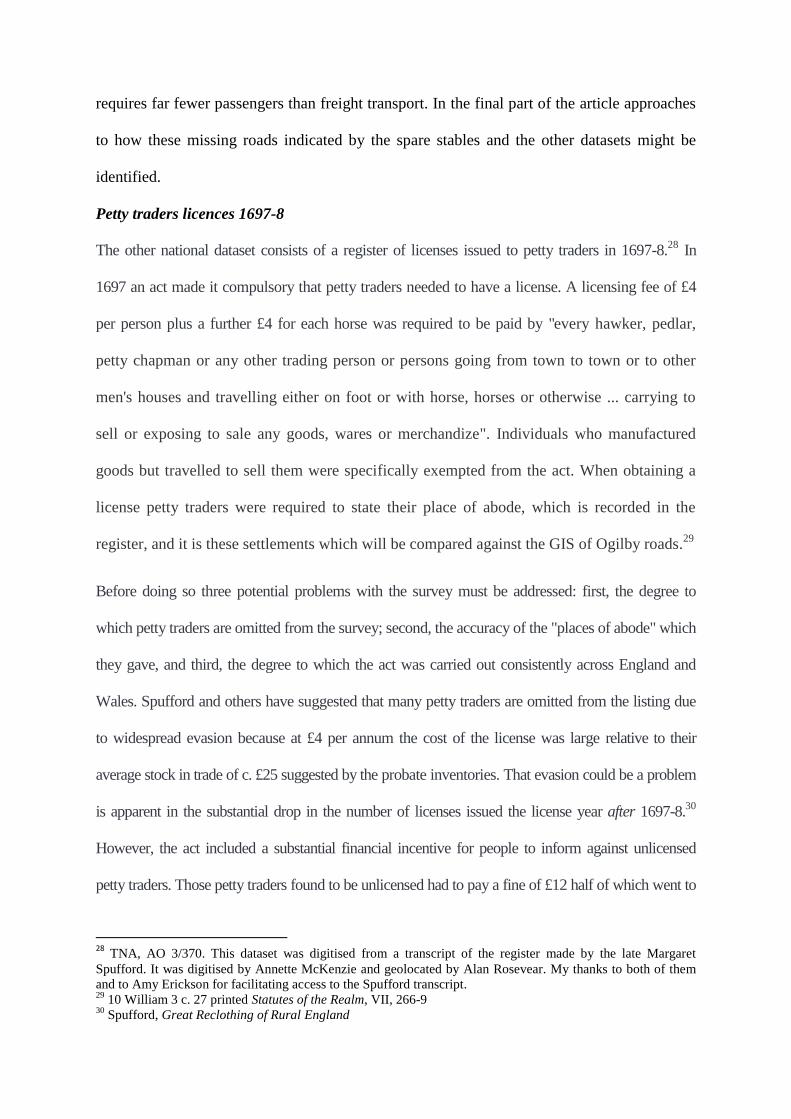
With these reservations in mind attention can turn to the geographical evidence. The register of
1697-8 lists 2386 individuals occupying 391 named places which if the returns for London,
Westminster and Southwark are consolidated into a single unit give a total of 374 settlements.36
London is the largest with 515 petty traders, but 202 of the settlement have only a single petty trader
and the mean number of traders per settlement is 6.4. Distribution, though widespread, is by no
means even. The absence of petty traders from most of Wales in consistent with the pattern exhibited
in the stabling places, but the relatively few places with licensed petty traders in parts of Eastern
England, important as it was in the textile industry either in terms of manufacture of the supply of
raw materials, may reflect differential enforcement of the statute of 1697 but this by no means
certain. In other areas the absence of chapmen from the map can be explained with more confidence
. The paucity of chapmen in the fenland, Yorkshire rivers area, and Severn valley probably reflects
the dominance of the carriage of freight by water in these areas (see Figure 8).
Of the 374 settlements, 212 are within one mile of an Ogilby road. This represents 1890 (79%) of the
traders and gives a mean of 8.9 traders per settlement. The impact of the large numbers of London
traders is not as great as might be thought. If London is removed from the calculation, the mean
number of traders per settlement within a mile of an Ogilby road falls to 6.5 but 73.5% of all non-
London traders are still within a mile of an Ogilby road. Those traders whose settlements lie further
than a mile from an Ogilby road represents a mean 2.9 traders per settlement. Of the 170 places with
petty traders lying more than a mile from an Ogilby road, 135 of them had only one or two petty
traders, and only six of the places have 10 or more petty traders. Two of these are regional centres of
36
M. Satchell and A. Rosevear, Petty Traders of England and Wales 1697-8, shapefile (Cambridge, 2017)
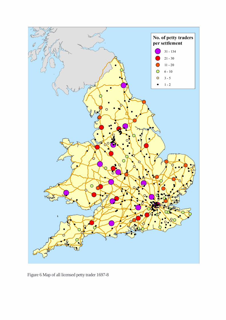
Figure 6 Map of all licensed petty trader 1697-8
some importance: Macclesfield, (32 petty traders, 72 horses) and Burton-on-Trent (10 petty traders)
The third place was the market town of Olney (Bucks), which 60 petty traders and five horses. The
concentration of petty traders at Olney was probably because its importance as a centre of the lace
making industry. According to a contemporary source Olney had the third highest number of lace
makers after Stony Stratford and Newport Pagnell.37
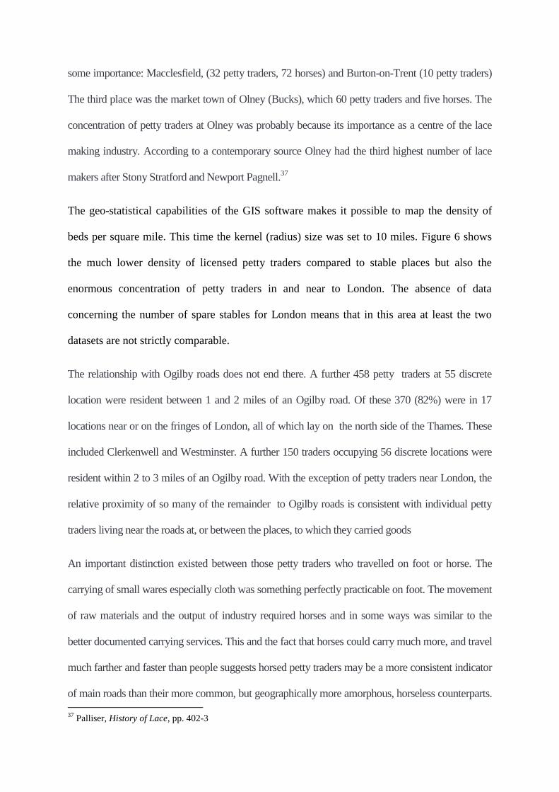
The geo-statistical capabilities of the GIS software makes it possible to map the density of
beds per square mile. This time the kernel (radius) size was set to 10 miles. Figure 6 shows
the much lower density of licensed petty traders compared to stable places but also the
enormous concentration of petty traders in and near to London. The absence of data
concerning the number of spare stables for London means that in this area at least the two
datasets are not strictly comparable.
The relationship with Ogilby roads does not end there. A further 458 petty traders at 55 discrete
location were resident between 1 and 2 miles of an Ogilby road. Of these 370 (82%) were in 17
locations near or on the fringes of London, all of which lay on the north side of the Thames. These
included Clerkenwell and Westminster. A further 150 traders occupying 56 discrete locations were
resident within 2 to 3 miles of an Ogilby road. With the exception of petty traders near London, the
relative proximity of so many of the remainder to Ogilby roads is consistent with individual petty
traders living near the roads at, or between the places, to which they carried goods
An important distinction existed between those petty traders who travelled on foot or horse. The
carrying of small wares especially cloth was something perfectly practicable on foot. The movement
of raw materials and the output of industry required horses and in some ways was similar to the
better documented carrying services. This and the fact that horses could carry much more, and travel
much farther and faster than people suggests horsed petty traders may be a more consistent indicator
of main roads than their more common, but geographically more amorphous, horseless counterparts.
37
Palliser, History of Lace, pp. 402-3
The register lists payments by the petty traders for 491 horses at 153 of the settlements. The
Macclesfield had the greatest number of horses with 72, 82 of the settlements had single horses and
the mean number of horses per settlement was 3.2. The relationship between the horsed chapmen
and Ogilby roads was weaker. Only 90 (58.8 %) of the settlements with horsed chapmen lay within a
mile of an Ogilby road and comprised 58.1% of all horses listed but the mean number of horses per
settlement was only 3.3. The 10 settlements beyond one mile of an Ogilby road with the most horses
were largely located on either side of the southern Pennines, and included Macclesfield, a pattern of
evidence for main roads similar to that shown by the spare stables.
To conclude this section on petty traders. Places with one or two petty traders are scattered
and do not have a convincing relationship with Ogilby roads but these individuals probably
represent the local traffic at the more attenuated sections of the road network. The weak
relationship between horsed petty traders and Ogilby roads on either side of the Pennines is
significant and suggests the importance of traffic in this region The density of settlements
with horsed petty traders is particularly striking on either side of the Pennines, a pattern
which has similarities with the distribution of spare stables. Likewise the paucity of petty
traders in many of the counties along the east coast has similarities with relative paucity of
spare stables in the same area.
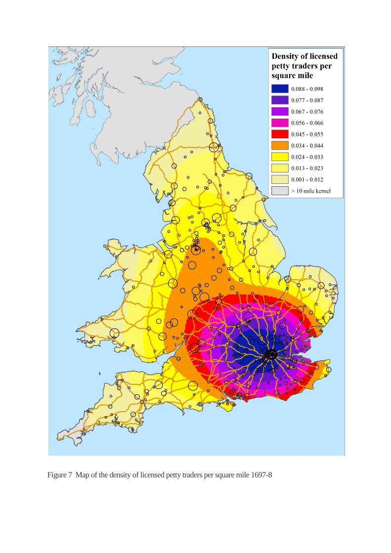
Figure 7 Map of the density of licensed petty traders per square mile 1697-8
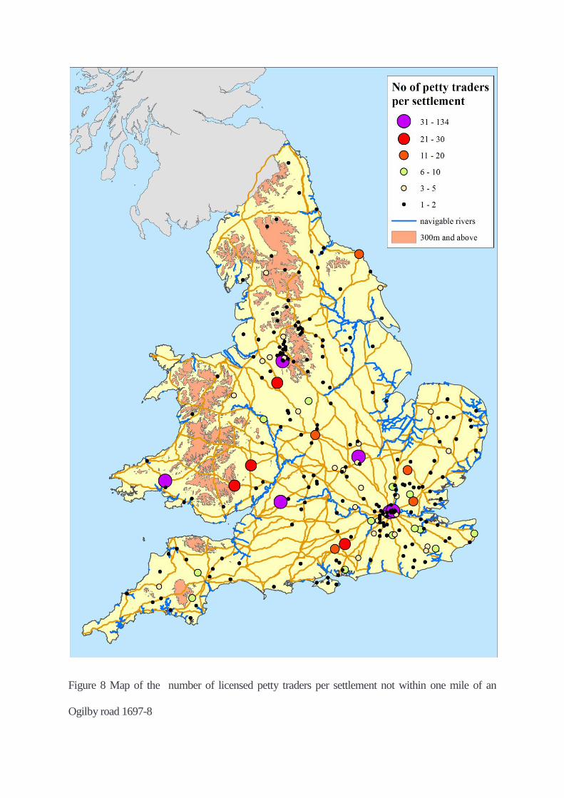
Figure 8 Map of the number of licensed petty traders per settlement not within one mile of an
Ogilby road 1697-8
Scheduled services from London 1637-1730
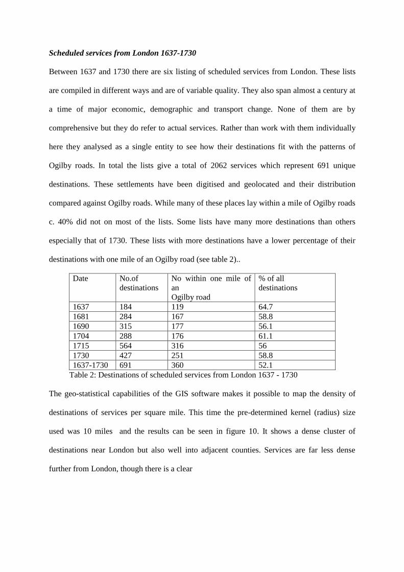
Between 1637 and 1730 there are six listing of scheduled services from London. These lists
are compiled in different ways and are of variable quality. They also span almost a century at
a time of major economic, demographic and transport change. None of them are by
comprehensive but they do refer to actual services. Rather than work with them individually
here they analysed as a single entity to see how their destinations fit with the patterns of
Ogilby roads. In total the lists give a total of 2062 services which represent 691 unique
destinations. These settlements have been digitised and geolocated and their distribution
compared against Ogilby roads. While many of these places lay within a mile of Ogilby roads
c. 40% did not on most of the lists. Some lists have many more destinations than others
especially that of 1730. These lists with more destinations have a lower percentage of their
destinations with one mile of an Ogilby road (see table 2)..
Date No.of
destinations
No within one mile of
an
Ogilby road
% of all
destinations
1637 184 119 64.7
1681 284 167 58.8
1690 315 177 56.1
1704 288 176 61.1
1715 564 316 56
1730 427 251 58.8
1637-1730 691 360 52.1
Table 2: Destinations of scheduled services from London 1637 - 1730
The geo-statistical capabilities of the GIS software makes it possible to map the density of
destinations of services per square mile. This time the pre-determined kernel (radius) size
used was 10 miles and the results can be seen in figure 10. It shows a dense cluster of
destinations near London but also well into adjacent counties. Services are far less dense
further from London, though there is a clear
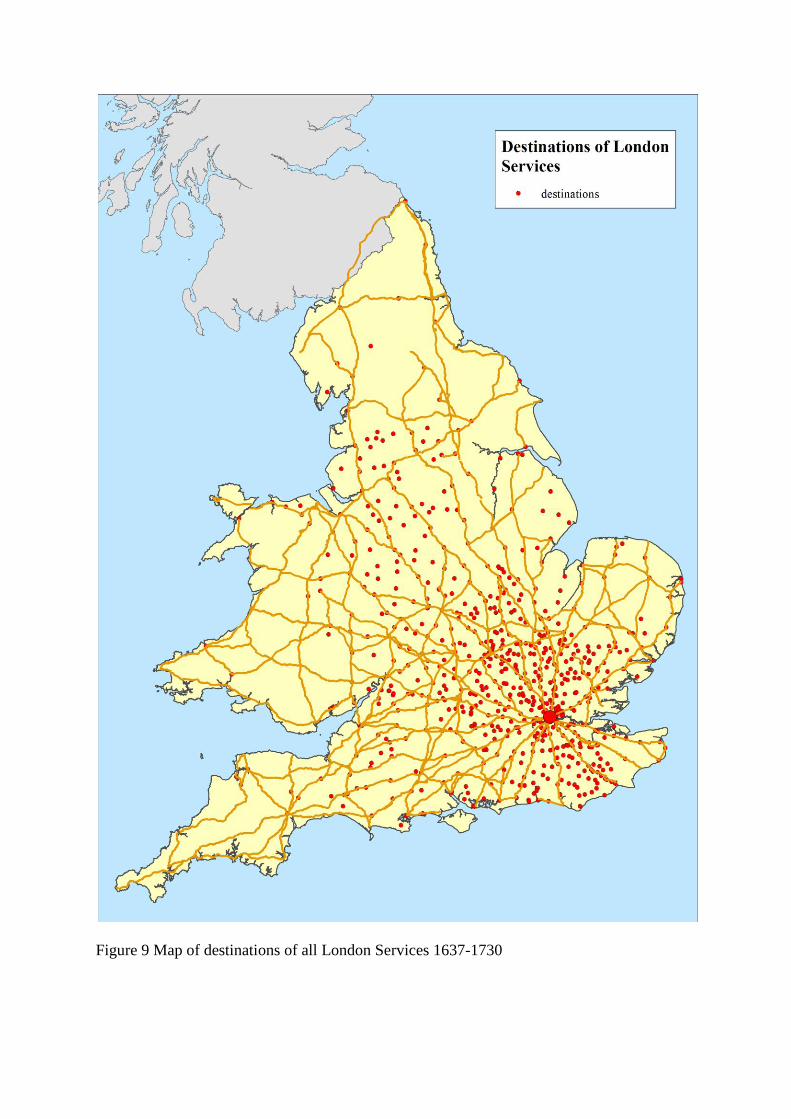
Figure 9 Map of destinations of all London Services 1637-1730
Figure 10 Map of density of London services destinations per square mile 1637-1730
Figure 11 Map of London services destinations not within one mile of an Ogilby road 1637-
1730
north-west/southeast pattern reaching as far north as the regions on either side of the southern
Pennines. This pattern in some ways resembles that of the stables density map (figure 4) and
also has correlations with the pattern of petty traders with horses as well.
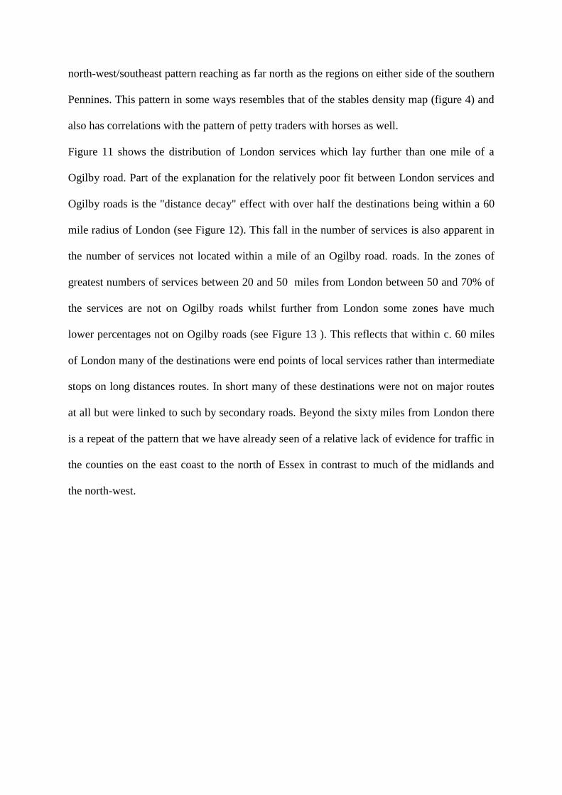
Figure 11 shows the distribution of London services which lay further than one mile of a
Ogilby road. Part of the explanation for the relatively poor fit between London services and
Ogilby roads is the "distance decay" effect with over half the destinations being within a 60
mile radius of London (see Figure 12). This fall in the number of services is also apparent in
the number of services not located within a mile of an Ogilby road. roads. In the zones of
greatest numbers of services between 20 and 50 miles from London between 50 and 70% of
the services are not on Ogilby roads whilst further from London some zones have much
lower percentages not on Ogilby roads (see Figure 13 ). This reflects that within c. 60 miles
of London many of the destinations were end points of local services rather than intermediate
stops on long distances routes. In short many of these destinations were not on major routes
at all but were linked to such by secondary roads. Beyond the sixty miles from London there
is a repeat of the pattern that we have already seen of a relative lack of evidence for traffic in
the counties on the east coast to the north of Essex in contrast to much of the midlands and
the north-west.
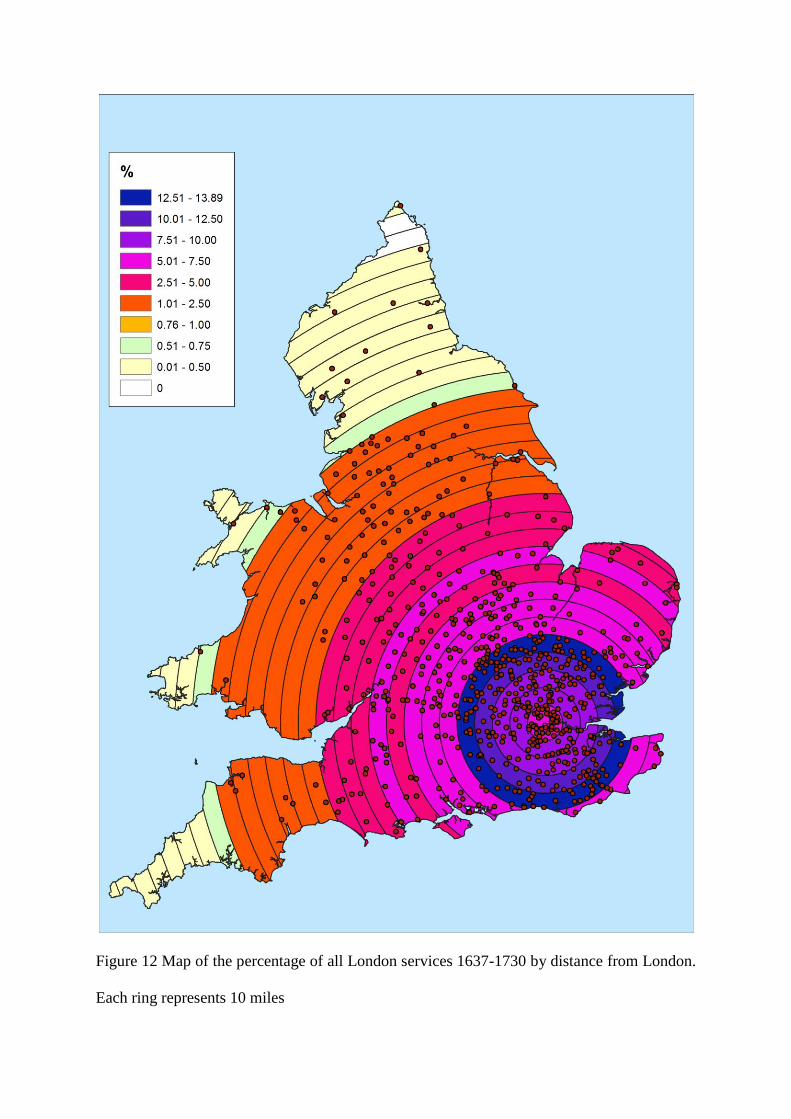
Figure 12 Map of the percentage of all London services 1637-1730 by distance from London.
Each ring represents 10 miles
Figure 13 Map of services not located within one mile of an Ogilby road by distance from
London - each ring represents 10 miles
Roads and routes
The next section of this paper assesses the evidence for roads and routes which may represent
important omissions of main roads from Britannia in three sources: early turnpike roads
1663-1730, early road books 1571 and 1679 and post roads 1675-1682.
Early turnpikes
Information concerning the network of main roads maintained by turnpike trusts in the
eighteenth century is potentially of value. From 1695 the maintenance of roads began to shift
decisively from parishes to turnpike trusts, though the earliest turnpike was 1663. Trusts took
over the maintenance of specific sections of pre-existing roads often because the volume of
traffic was overwhelming the available road maintenance resources of the parishes through
which the roads ran. In this early period turnpike trusts rarely built new roads. By far the
greatest part of their work was the taking over the maintenance of existing roads. The
wording of the titles of the acts are usually explicit as to whether the trust is adopting an
existing roads or making a new one. This means that some of the information concerning the
network of main roads in the eighteenth century has the potential to projected back
legitimately to the seventeenth century and is valuable because the roads chosen may have
been busy ones.
Care must be taken, however, because the network of main roads underwent an accelerated
rate of change especially with the rapid increase in the mileage of roads turnpiked with the
onset of so-called turnpike mania from 1750.38
Even before this date there were major
changes. For example, the shift in goods carriage from sea to road due to depredations of
French privateers following the commencement of the War of Spanish Succession in 1701
would have dramatically increased the amount of traffic on some roads and may have been
responsible for the turnpiking of some routes which previously had been unimportant. For
38
Albert, The turnpike road system in England, p. 49
example, this seems to be the explanation of turnpike acts of 1706, 1707 and 1714 concerning
roads serving the cloth towns of Calne, Chippenham and Devizes.39
Another issue is that a substantial amount of the early turnpike mileage derives from town-
centred trusts. This type of trust were responsible for all the access roads leading into a
particular town. While some of these roads could represents of regional even national
importance others were of only local significance. Nine of town-centred trusts had been
formed by 1730.
A further problem is that while existing established main roads between two places could be
chosen to be turnpiked this was not necessarily the case. Sometimes other roads would be
adopted instead. For example, when the route for the turnpike from Goldalming to Duncton
(Sussex) was chosen the section of the road mapped by Ogilby between Hambledon and
Chiddingfold was passed over for an alternate more-level route via Milford. This was because
the Ogilby road was "very hilly and in many places very narrow and leads through several
deep and hollow ways", and the expense of repairing and widening the existing road was
deemed too great.40
Other examples can be cited, such as some of the turnpikes of the
Salisbury Plain.
As digitised by Rosevear and Satchell 2319 miles of road had been turnpiked between 1663
and 1730.41
Of this 1274 miles (54.9 % of the total) were sections of pre-existing roads that
appear in Britannia. In total there were 171 settlements with stables within one mile of the
early turnpikes. Of these, 140 settlements were within one mile of the ex-Ogilby turnpikes.
These had a total of 31738 places which represented a massive 36.3% of the national total. Of
39
Albert, The Turnpike Road System in England, 44 40
JHC, XX (1757), 605; G. Joan Fuller, 'The development of roads in the Surrey and Sussex Weald and
coastlands between 1700n and 1900', Transactions and Papers British Institute of Geographers, 19 (1953), pp.
37-49: 41 41
A. Rosevear, .M. Satchell, D. Bogart, L. Shaw-Taylor, Turnpikes Roads of England and Wales 1663-1892',
shapefile (Cambridge, 2017)
these the largest settlement was St Albans with 1689 stables - the largest number of stables
belonging to a single settlement in the entire dataset. The mean number of stable places per
settlement within one mile of the ex-Ogilby turnpikes was 226.6 a figure far higher than the
national one of 103.3. Despite having only a slightly lower mileage than the ex-Ogilby
turnpikes, the non-Ogilby turnpikes had only 31 settlements with stables within one mile of
them. These represented a total of 2063 stable places which was only 2.4% of the national
total. Of these settlements, Liverpool was the largest with 339 stable places but the mean
number of stable places was only 66.5 again well below the national figure. This suggests
that the ex-Ogilby turnpikes had more inns and a higher level of traffic than Ogilby roads in
general and by way of contrast the other turnpikes had significantly fewer inns and less traffic
than normal.
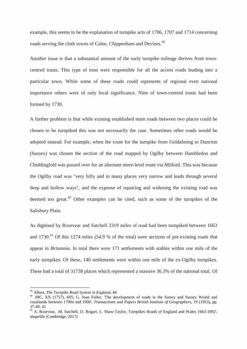
Figure 14 Map of Turnpikes Roads which 1663 -1730 (green) and Ogilby roads 1675
(black) - detail around London and West Country
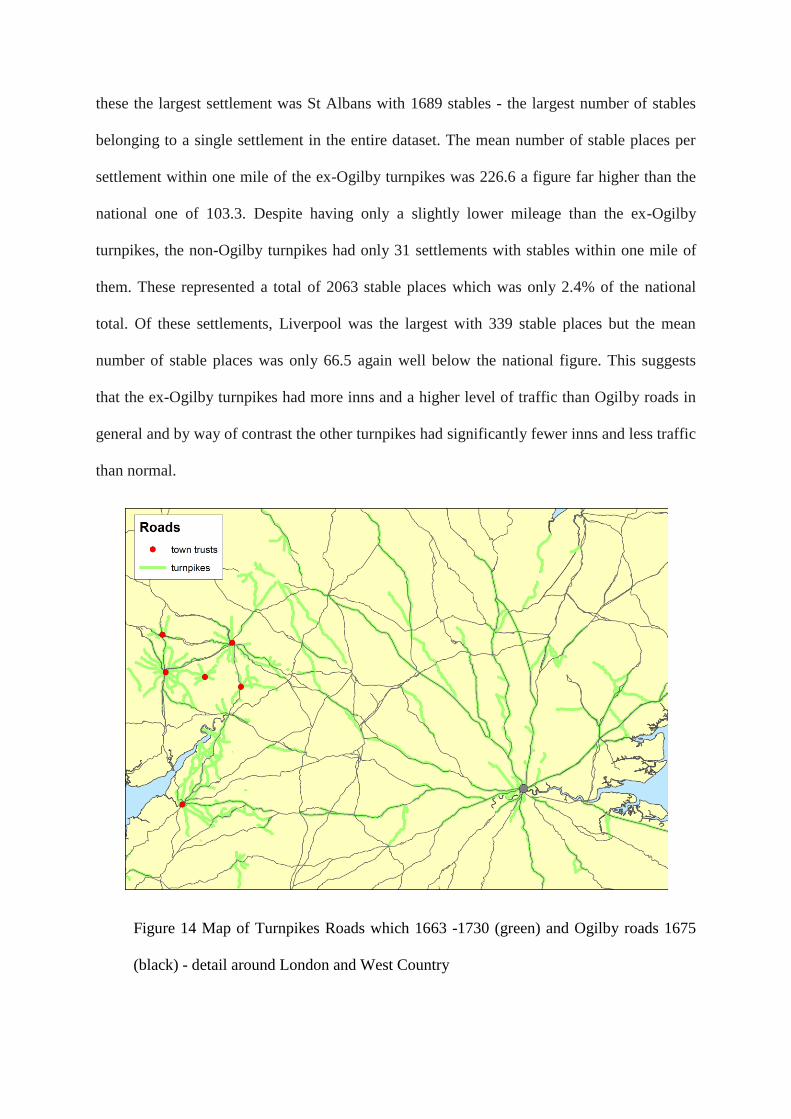
Figure 15 National map of early turnpike roads whose act were passed before 1731
The density of settlements with stables can also be compared along both the ex-Ogilby and
non-Ogilby sections of roads to get an idea of the importance of each class of road. If the
number of miles per settlement with stable places is calculated nationally, the roads of
Britannia have one settlement with stables every 19.9 miles. The ex-Ogilby turnpikes have
almost twice the level of density with a settlement with stable places every 9.1 miles. The
other turnpikes have a density of stable places lower than the national figure for Britannia
with a density of settlement with stables every 33.7 miles. This suggests the turnpikes had far
less traffic than the Ogilby ones.
The numbers of stables per mile of road again shows the dominance of the ex-Ogilby
turnpikes. Whereas the other turnpikes had 2 stable places per mile of road, the ex-Ogilby
turnpikes had a massive 28.9 stable places per mile. This is not to say that none of the
turnpikes which were omitted from Britannia were not main roads, the turnpike leading from
Prescot to Liverpool, for example, must have been. The picture that emerges is that the non-
Ogilby turnpikes were relatively less important in general. Looking at the map of the two
types of turnpike its not hard to see why. The ex-Ogilby turnpikes include all the major
approach roads to London, large sections of the roads to the channel ports, and sections of the
great post roads to Holyhead and Bristol. The non-Ogilby turnpikes by way of contrast are a
disparate bunch including a number of town trusts belonging to second rate regional centres
(see Figure 15).
Road books
Road books give the origin, destination and intermediate stages of roads in England and to a
lesser extent Wales both before and after the publication of Britannia. The content of road
books published before Britannia derives largely from a handful of printed chronicles of the
sixteenth century, the sources of which concerning roads are uncertain. The authors' of the
chronicles connections with trade are usually sufficiently unclear that it would be unwise to
assume the routes they indicate were necessarily those followed by travellers and carriers.42
In the case of the listing of routes published by William Harrison he does make a direct link
between inns and the stages of .the routes. He describes his listing as "a table of the best
thoroughfares [a term he uses to indicate towns through which there is much passage of
travellers] and towns of greatest travel of England, in some of which there are twelve or
sixteen ... inns.43
Like Ogilby, roadbooks also have a London-centric bias in terms of the
routes listed. In terms of date and content, therefore, the connection between roadbooks and
the transport network of the late seventeenth century is not certain and has never been
systematically investigated.
If the routes of the road books are mapped as a series of straight lines between their stages, it
is surprising how few of the routes are not in Ogilby. The largest and most comprehensive of
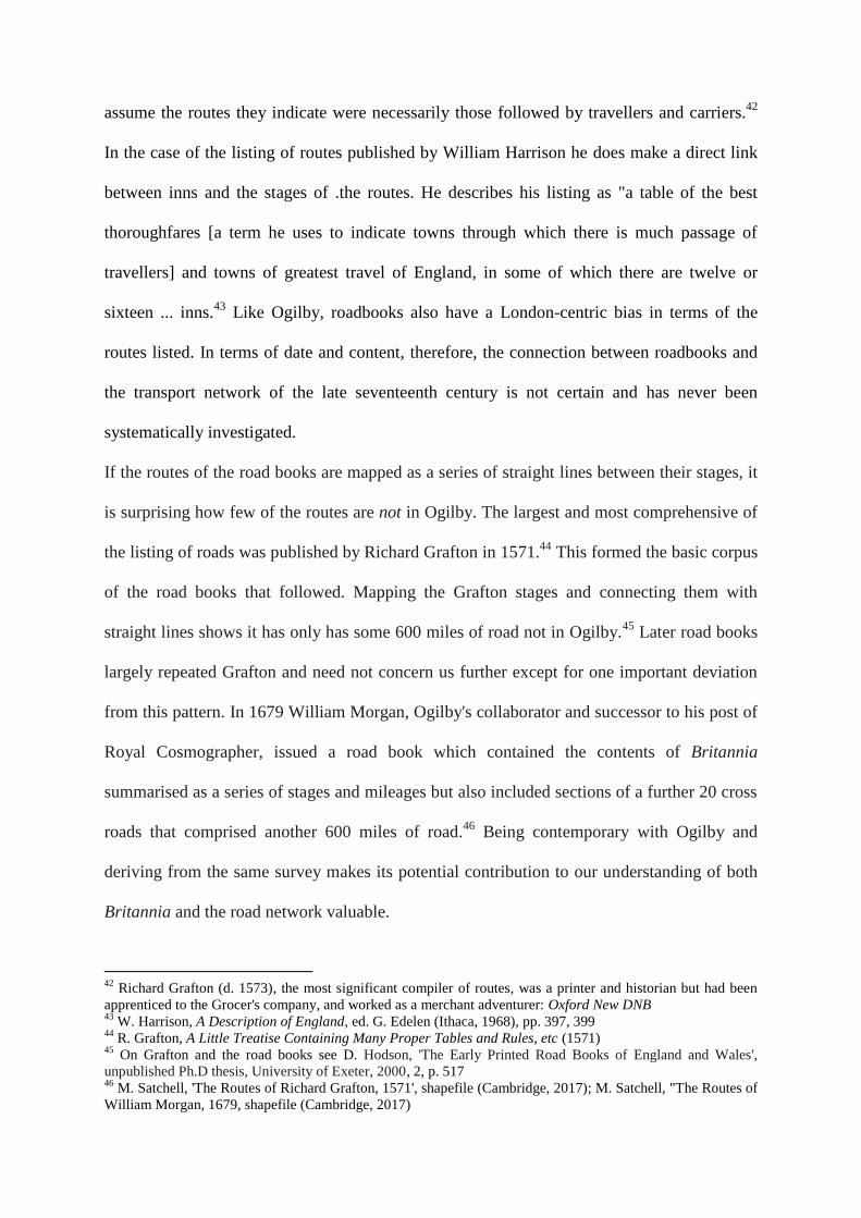
the listing of roads was published by Richard Grafton in 1571.44
This formed the basic corpus
of the road books that followed. Mapping the Grafton stages and connecting them with
straight lines shows it has only has some 600 miles of road not in Ogilby.45
Later road books
largely repeated Grafton and need not concern us further except for one important deviation
from this pattern. In 1679 William Morgan, Ogilby's collaborator and successor to his post of
Royal Cosmographer, issued a road book which contained the contents of Britannia
summarised as a series of stages and mileages but also included sections of a further 20 cross
roads that comprised another 600 miles of road.46
Being contemporary with Ogilby and
deriving from the same survey makes its potential contribution to our understanding of both
Britannia and the road network valuable.
42
Richard Grafton (d. 1573), the most significant compiler of routes, was a printer and historian but had been
apprenticed to the Grocer's company, and worked as a merchant adventurer: Oxford New DNB 43
W. Harrison, A Description of England, ed. G. Edelen (Ithaca, 1968), pp. 397, 399 44
R. Grafton, A Little Treatise Containing Many Proper Tables and Rules, etc (1571) 45
On Grafton and the road books see D. Hodson, 'The Early Printed Road Books of England and Wales',
unpublished Ph.D thesis, University of Exeter, 2000, 2, p. 517 46
M. Satchell, 'The Routes of Richard Grafton, 1571', shapefile (Cambridge, 2017); M. Satchell, "The Routes of
William Morgan, 1679, shapefile (Cambridge, 2017)
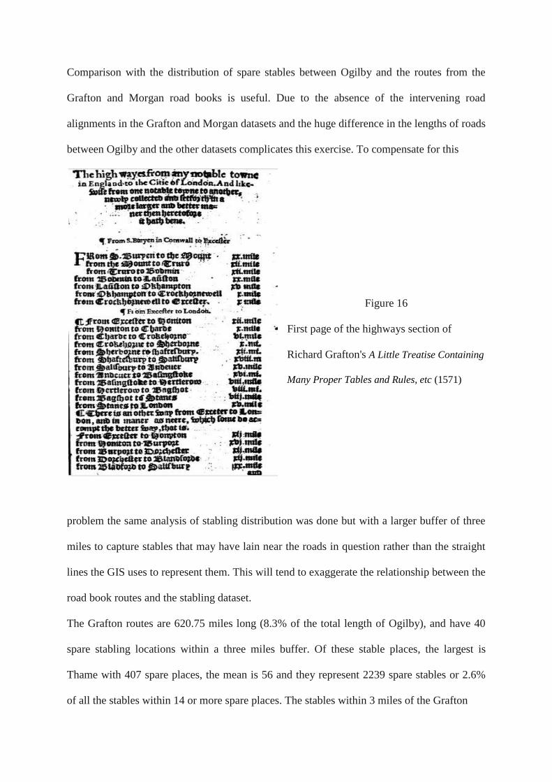
Comparison with the distribution of spare stables between Ogilby and the routes from the
Grafton and Morgan road books is useful. Due to the absence of the intervening road
alignments in the Grafton and Morgan datasets and the huge difference in the lengths of roads
between Ogilby and the other datasets complicates this exercise. To compensate for this
Figure 16
First page of the highways section of
Richard Grafton's A Little Treatise Containing
Many Proper Tables and Rules, etc (1571)
problem the same analysis of stabling distribution was done but with a larger buffer of three
miles to capture stables that may have lain near the roads in question rather than the straight
lines the GIS uses to represent them. This will tend to exaggerate the relationship between the
road book routes and the stabling dataset.
The Grafton routes are 620.75 miles long (8.3% of the total length of Ogilby), and have 40
spare stabling locations within a three miles buffer. Of these stable places, the largest is
Thame with 407 spare places, the mean is 56 and they represent 2239 spare stables or 2.6%
of all the stables within 14 or more spare places. The stables within 3 miles of the Grafton
Figure 17 Map of roads in Grafton (1571) and Morgan (1679) not in Britannia (1675)
routes includes several other towns with a substantial number of stables: Chard (345),
Bodmin (264), Wolverhampton (234).
The roads exclusive to Grafton have a different pattern to those in Ogilby. If the number of
miles per stable places is calculated, the Ogilby roads have a stable every 19.9 miles whereas
the Grafton roads have a stable every 15.5 miles. If the overall number of stable places per
mile is calculated Ogilby has 11.54 stables per mile, whereas Grafton has 3.6 stable places
per mile. This is consistent with a greater density of smaller inns on the Grafton road which
makes sense when it is remembered that the largest inns were found in the bigger towns. This
suggests that the roads of Grafton were of importance but less so than some of the Ogilby
routes.47
The Morgan routes are 650.49 miles long (8.7 % of the total length of Ogilby), and have 45
spare stabling locations within a three miles buffer. Of these stable places the largest is
Alverstoke (Hampshire) with only 60 spare places, the mean size is 23.4 and they represent
only 819 spare stables places or 0.9% of all the stables within 14 or more spare places
dataset. The roads exclusive to Morgan seem more marginal than those in Ogilby. If the
number of miles per stable places is calculated, which the Morgan roads have a stable every
18.6 miles which is very similar to the Ogilby figure of 18.9 miles. If the overall number of
stable places per mile is calculated, Ogilby has 11.54 stables per mile, whereas Grafton has
1.26 stable places per mile. This is consistent with routes with a similar density of settlements
with inns but far fewer inns per settlement and/or stabling places per inn. This does not mean
at least some of these roads were not important but it does suggest that they were less
important than many of those included in Britannia and less important than those exclusive to
Grafton. Given the degree of collaboration between Ogilby and Morgan, and the obvious
holes in what was included in Britannia, this is a significant conclusion. It suggests that
47
Chartres, 'The Eighteenth Century English Inn', 210-12
Morgan, and perhaps by implication by Ogilby himself, were aware that there were other
roads that should have been included in Britannia but were not clear which roads these
should be. The inclusion in the road book of the road between two obscure Norfolk villages -
Twyford and Great Snoring - which are not within three miles of any of the stables places,
suggests Morgan at least did not know which routes to include or exclude.
Postal routes 1675-1682
Postal routes are of value for indicating main roads in that they had regular postal services
two or three times a week and post offices hired guides and post horses to travellers in this
period.48
In 1675 the postal network was a mixture of long-established post roads and by-post
roads, by-post roads re-established after the Restoration, and newly established by-post roads.
It is apparent that the establishment of new routes began to be linked to current demand from
the 1660s. An important bypost to Derby from Towcester on the London to Holyhead road
was established in 1660 and this was extended from Derby to Sheffield via Chesterfield in
1663.49
In June 1675 the branch from Canterbury to Maidstone was extended to Ashford via
Lineham and Charing, which lay close to but not on the Ogilby road, and in September 1675
the existing road to Arundel was extended to Steyning, Shoreham, Brighton and Lewes.50
Postal routes are valuable for indicating routes because unlike most other travel information
from this period their course can be traced along the length of the route not just at the start
and end point. Postal routes, however, were all orientated towards the great post roads
leading to London. It was not till 1696 that the first true cross-post bypassing London was
established connecting Bristol to Exeter. Hitherto letters first had to travel into London and
then out again.51
As a consequence, the flow of post, and by definition, the route followed by
48
Gerhold, Carriers and Coach masters, 96. 49
Its importance may be indicated by it being one of the few by-posts published in lists of post roads. See for
example J. Smith, Speculum Anni (1675) 50
London Gazette, 6 September 1675, Issue 1022, p. 2; B. Austen, English Provincial Posts 1633-1840
(London, 1978), 21; Ogilby plate 20 51
Robinson, The British Post Office, p. 81
post roads between towns via London sometimes differed from the roads normally used to
move of goods and people where there were more direct routes between such places.
Two lists survive for the postal routes of England and Wales and their stages in the 1670s.
One was published by Ogilby in the preface of Britannia in 1675 and probably derives from
an official source. The other list is slightly later in date and was written by Thomas Gardiner,
sub post master general. This list derives from reviews of the Post Office c. 1677 and 1682.52
The Ogilby and Gardiner lists are very similar, though the latter is better known amongst
historians having been published in 1958. Comparisons between the two indicates the Ogilby
list is generally reliable. Current knowledge on the expansion of the postal network in the
1670s means that in most cases we cannot be sure the differences represent errors in the
Ogilby list. To manage this problem a composite "maximum" GIS of post stages and roads
using all the elements from both sources was created.53
This consists of post stages as points
and roads between them represented as straight lines between successive stages.54
Two
obvious errors in Kent have been corrected and stages and branch roads listed in Gardiner but
omitted from Ogilby have been added. 55
This may have the effect of making the postal
network a little larger than it actually was in 1675.
52
Hodson, 'The Early Printed Road Books of England and Wales', 2, 421-2, 431 53
The Ogilby post routes have also been listed and mapped by Hodson, though he omitted three stages from his
listing, Tyndomen (Montgomeryshire) on the Birmingham - Aberdovey by-post road, Bradish (Suffolk) an
unlocated stage on the Ipswich - Scole by-post road and Hiworth (Derbyshire) which is the unlocated terminus
of a by-post road from Derby. He also mis-located a few of the stages, such as Chipstead and Thanet (Kent) and
he mismapped a few of the roads, such as the Great Western road which he maps as going directly Penryn to
Marazion which he maps as commencing at Newark; and he omitted a few by-posts all-together, such as four
by-posts from the road from Royston to Norwich.
54 M. Satchell, The Post Stages of England and Wales 1675-1682, shapefile (Cambridge, 2017); M. Satchell,
'The Post Routes of England and Wales 1675-1682, shapefile (Cambridge, 2017).' 55
According to Gardiner branch post roads terminating at Wainfleet and Grimsby leave the Great North Road
from Newark. Ogilby has them departing the Great North Road at Grantham. Ogilby has Gravesend and
Faversham as stages on the Dover road whereas Gardiner correctly has them as branch roads departing the
Dover road from Dartford and Sittingbourne respectively: Austen, English Provincial Posts, pp. 20, 23.
Gardiner omits Penryn but its status as a stage on the branch road to Marazion is mentioned in the Post Office
Act of 1660: 12 Charles II c. 35. Ogilby has a branch road from Rochester terminating at Maidstone whereas
Gardiner extends it to Ashford. Both are probably correct: Ashford was not established as a post office in June
1675 not long before the publication of Ogilby's Britannia in November of that year: Austen, op. cit., 21;
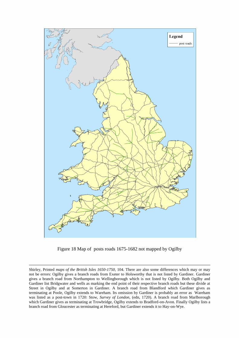
Figure 18 Map of posts roads 1675-1682 not mapped by Ogilby
Shirley, Printed maps of the British Isles 1650-1750, 104. There are also some differences which may or may
not be errors: Ogilby gives a branch roads from Exeter to Holsworthy that is not listed by Gardiner. Gardiner
gives a branch road from Northampton to Wellingborough which is not listed by Ogilby. Both Ogilby and
Gardiner list Bridgwater and wells as marking the end point of their respective branch roads but these divide at
Street in Ogilby and at Somerton in Gardiner. A branch road from Blandford which Gardiner gives as
terminating at Poole, Ogilby extends to Wareham. Its omission by Gardiner is probably an error as Wareham
was listed as a post-town in 1720: Stow, Survey of London, (edn, 1720). A branch road from Marlborough
which Gardiner gives as terminating at Trowbridge, Ogilby extends to Bradford-on-Avon. Finally Ogilby lists a
branch road from Gloucester as terminating at Hereford, but Gardiner extends it to Hay-on-Wye.
Comparison between the listings of post roads and the roads mapped in Britannia shows the
main post roads were mapped virtually in their entirety as might be expected, but of the 79
by-post roads, 60 were either partially or wholly omitted by Ogilby.56
If the postal network is
represented as straight line distances between postal stages, it is 3690.2 miles in length,
though 1550.2 of this represents the 6 great post routes mapped by Ogilby as part of his plan
for Britannia. Of the remaining 2120 miles, at least 1352.1 miles (63.7 %) are not part of the
network mapped by Ogilby. In at least one instance Ogilby included a road in Britannia that
was a former post route but ceased to have this status before 1675. Post to Ireland via Carlisle
had until the 1660s departed from the London-Edinburgh road at Newcastle. This road is
shown by Ogilby whereas the Greta Bridge - Penrith section of the 1675 postal route across
the Pennines from Northallerton to Carlisle via Stainmore is omitted.57
The postal routes not mapped by Ogilby have 53 settlements with spare stables within a three
mile buffer. Of these, the largest is Liverpool with 339 spare places, the mean size is 78.5 and
they represent only 4160 spare stables or 4.8% of all the stables within the 14 or more spare
places dataset. The roads exclusive to post routes dataset include some other towns with
substantial stabling provision, such as Sheffield (319 stable places), Ashbourne (305),
Wisbech (291), Bodmin (264) and Wolverhampton (234).. If the number of miles per stable
places is calculated, the Ogilby roads have a stable every 18.9 miles, whereas the routes
exclusive to post roads have a stable only every 25.5 miles. If the overall number of stable
places per mile is calculated Ogilby has 11.54 stable places per mile, whereas the routes
exclusive to post roads have only 3.1 stable places per mile. The very substantial stabling
capacity of a few of the towns is in contrast to the relatively low numbers of stables per mile.
The artificial nature of the postal network with the rerouting of mail back to London may
56
There is evidence of a few deviations. For example, the London to Bristol road between 62 and 75 mile
marks immediately east of Marlborough has two roads mapped with the comment "the left being the Post-Way
by Hungerford, but the right being the more usual being both the Coach and Plow way by Ramsbury. 57
Ayres, Mail Routes, p. 44
explain this. This does not mean at least some of these roads were not important but it does
suggest that in general they were less important than those included in Britannia.
We are now in a position to pull the disparate threads of this paper together. To summarise:
hitherto discussion of the status of the roads in Britannia have been impressionistic. This
situation has now changed due to the creation of a digital map of Ogilby's atlas and its
interrogation in relation to other datasets that reflect the geography of road transport in the
late seventeenth century. For settlements this represents places that had a strong provision of
inns in 1686, places that were a base for petty traders in 1697-8 or were destinations for
scheduled services from London 1637-1730. For roads or routes omitted from Britannia this
is some early turnpikes, some postal routes, and sections of the routes of the Grafton and
Morgan roadbooks. The spare stables settlement data is by far the largest and most
comprehensive of the datasets. Comparison between it and the roads of Britannia shows that
the most towns with a large provisions of stables were within a mile of an Ogilby road. Of the
176 towns with 100 or more spare stable places only 24 (13.6 %) were not. The evidence of
stabling also shows that Ogilby did omit some busy roads. There are 86 places with 50 or
more stables not within a mile of Ogilby roads. The clustering of many of them in a roughly
north-west/ southeast shape stretching from either side of the southern Pennines to London is
suggestive of the area of major traffic some of which was omitted from Ogilby. This same
pattern is also seen in the settlements of petty traders and the destinations of London carrying
services not near Ogilby roads.
The road and route data show that the omitted roads had a lower provision of inns compared
to the roads of Britannia which suggests they had less traffic. This does not mean that some
them were not important. The turnpike evidence is particularly striking showing that those
turnpikes that were also mapped in Britannia had a far higher density of inns than both the
national average for roads in Britannia and more significantly those turnpikes which were
omitted from it. This reinforces the conclusions of the stabling data that the atlas included
many but not all of the main roads.
Joining up the dots: The missing network
The conclusion that Britannia did omit some important roads raises the questions "Can we
identify them?". In the absence of road or route data the task of identifying the missing trunk
or main roads must focus first on the nodes indicated by settlements with substantial amounts
of spare stabling. In themselves the settlements with these characteristics give no clue as to
the origin and destination and roads used by the people and horses who occupied the beds and
stalls enumerated in 1686. Given the extensive nature of the overall road network compared
to that of main roads and the degree to which much of it had changed before being
systematically mapped, caution must be applied in selecting particular road linkages as
representing the missing main roads.
However, there are lots of sources of evidence both "inferential" and "actual". First off, and
rather obviously, traffic was not random but flowed in relation to the needs of the economy
and the cost of transport. The enormous cost advantage moving goods by water meant that
where topography allowed: " the chief function of roads was to bring traffic to the point,
whether inland or coastal port, where it could leave them for less expensive modes of
travel".58
This has been borne out by the analysis of spare stables which has found a number
of sea ports and important transhipment points on inland waterways not located on the Ogilby
network have among the highest numbers of spare stables. This makes connecting them to the
network of Ogilby roads a priority but also renders the task of so doing easier - the direction
of travel will be in most cases obvious. Attention to information concerning the types of
regional specialisation, commodities produced and so on can suggest possible directions the
traffic of the missing main road might be likely to take and this can then be investigated.
58
Court, Rise of Midlands Industries, p. 13
Likewise in circumstances where a nodal settlement also had a scheduled service to London
then the possibility of the main road having its primary orientation to London can be
assessed. The exigencies of travel meant that there were stages/ stopping places at regular
intervals on main roads which should be apparent as other places with spare stables.
Assessment of one stable node must take place in relation to others in the locality.
The strip maps of Britannia contain considerable information concerning other roads because
they record in great detail the destinations of the many intersections which branch from its
"principal routes". For example, though Britannia does not map a road directly to the port of
Liverpool, its map of the road to Carlisle marks no less than three intersections to Liverpool
marked with considerable precision at 182 miles, 187 miles 6 furlongs and 194 5 furlongs
from London.59
So in this case not only is the direction of travel obvious but the points where
the missing trunk road/s left the network are obvious too. We have yet to fully exploit the
value of the intersections of Britannia as a guide as to help reconstruct roads omitted from
Britannia, though Frearson's use of them along with other cartographic sources to reconstruct
the network of highways and secondary roads of the Chilterns (Buckinghamshire), represents
a clear demonstration of their potential.60
In a sense, though Britannia is largely an atlas of
London main routes and branches with a few cross routes, the intersections indicate the existence of
an implicit road network far larger than what is mapped in the atlas.
Other maps with roads are an obvious source of information but must be interpreted with
considerable care. These are primarily of two types large scale detailed county maps most of
which are not produced till well into the turnpike era and small scale maps with roads either
for the country as a whole or for individual counties. Harvey and Thorpe's careful comparison
of how roads were depicted on the maps of the county of Warwickshire, for example, show
59
Britannia, plate 37 60
M. Frearson, 'The Mobility and Descent of Dissenters in the Chiltern Hundreds', in M. Spufford, The World of
Rural Dissenters (Cambridge, 1995), pp. 273-87: 278, 282
the degree of copying and recopying, random omissions, and other hazards that await the
would-be user. 61
There are also documentary sources that are of great value for identifying missing main
roads. The quarter sessions indictments for parishes whose roads were in a poor state are a
valuable indicator of heavy traffic indicative of main roads. For example, 44 out of 66 quarter
session presentments concerning keeping roads in good order in Hertfordshire from 1619 to
1661 were against parishes on the Great North Road.62
Diaries, annotated almanacs, and the
like giving details concerning routes taken on journeys represent a vast but as yet largely
untapped amount of material, though a grant application is now in place which will hopefully
soon begin to change this situation.63
Other sources are informative about particular regions
or particular routes but exigencies of space precludes further discussion.
This short discussion of the sources for identifying the main roads omitted from Britannia
makes it clear that the work of identifying and adding the missing elements of the network of
main roads is not a small or simple task. Work towards this goal is ongoing within the
research team with a preliminary network recently added to the Ogilby GIS. Funding
permitting it is hoped to make a substantive upgrade to this network in the not too distant
future.
61
P.D.A. Harvey and H. Thorpe, The Printed Maps of Warwickshire 1576-1900, Warwick County Occasional
Series (Warwick, 1959), pp. 6, 11, 16-17, 18, 30-1 62
Albert, Turnpike Road System in England 1663-1840 (Cambridge, 1972), p. 18. See also Court on quarter
session evidence for roads in Worcestershire: W.H.B. Court, Rise of Midland Industries 1600-1838 (Oxford,
1938), pp. 16-17 63
For an example of using diary sources for journeys to good effect see Gerhold, Carriers and Coachmasters.
Annotated calendar sections of almanacs represent a vast and as yet untapped source of travel information. For
an example, see the discussion of the annotations in a copy of Daniel Browne's A new almanacke and
prognostication for the yeere of our Lord God 1625 complete with transcribed annotations giving details of
contemporary journeys in the Cheshire-Lancashire region: http://mcrsrarebooks.blogspot.co.uk/2010/07/notes-
for-march-sig.html (consulted 21 May 2017)