hydrology of vernal pools at three sites, southern ... of vernal pools at three sites, southern...
TRANSCRIPT

Hydrology of Vernal Pools at Three Sites, Southern Sacramento Valley
FHWA/CA/IR-2004/08
Robert J. Williamson, Graham E. Fogg, Marc Cable Rains,
and Thomas H. Harter
Department of Land, Air and Water Resources
Hydrologic Sciences Graduate Group University of California, Davis
Final Report For Project: F 2001 IR 20
Developing a Floristic Statewide Vernal Pool Classification, and a Functional Model of Pool Hydrology and Water Quality

Hydrology of Vernal Pools at Three Sites, Southern Sacramento Valley
Robert J. Williamson, Graham E. Fogg, Marc Cable Rains,
and Thomas H. Harter
Department of Land, Air and Water Resources Hydrologic Sciences Graduate Group
University of California, Davis
April 22, 2005
FINAL TECHNICAL REPORT Submitted to California Department of Transportation for the project: F 2001 IR 20 Developing a Floristic Statewide
Vernal Pool Classification, and a Functional Model of Pool Hydrology and Water Quality
1
STATE OF CALIFORNIA DEPARTMENT OF TRANSPORTATION TECHNICAL REPORT DOCUMENTATION PAGE TR0003 (REV. 10/98) 1. REPORT NUMBER
FHWA/CA/IR-2004/08
2. GOVERNMENT ASSOCIATION NUMBER
3. RECIPIENT’S CATALOG NUMBER 5. REPORT DATE
April 22, 2005
4. TITLE AND SUBTITLE
Hydrology of Vernal Pools at Three Sites, Southern Sacramento Valley
6. PERFORMING ORGANIZATION CODE
7. AUTHOR(S)
Robert J. Williamson, Graham E. Fogg, Marc Cable Rains, and Thomas H. Harter
8. PERFORMING ORGANIZATION REPORT NO.
10. WORK UNIT NUMBER
9. PERFORMING ORGANIZATION NAME AND ADDRESS Department of Land, Air and Water Resources Hydrologic Sciences Graduate Group
University of California, Davis
11. CONTRACT OR GRANT NUMBER F 2001 IR 20
13. TYPE OF REPORT AND PERIOD COVERED Final Report
12. SPONSORING AGENCY AND ADDRESS
California Department of Transportation Sacramento, CA 95819
14. SPONSORING AGENCY CODE
15. SUPPLEMENTAL NOTES This is the final report for the project: Developing a Floristic Statewide Vernal Pool Classification, and a Functional Model of Pool Hydrology and Water Quality. This project was done by U. C. Davis and sponsored by the California Department of Fish and Game and the California Department of Transportation (Caltrans) with partial funding provided by the Packard Foundation. Caltrans specifically funded for the vernal pool hydrology aspect of the study, which is covered in this report. The vegetation aspect is briefly summarized in the Foreword/Executive Summary.
16. ABSTRACT The subsurface hydrology of vernal pools at three vernal pool complexes was investigated during three wet seasons in 2002-2004. The complexes were at Gridley Ranch, Valensin Ranch, and the Mather Field in northern California. The selected complexes provided variation in soils, landforms and topography. Three vernal pools were chosen in each complex based on variation in pool type, size, and position in the drainage system. The objectives were to describe the subsurface hydrology of vernal pools to refine the conceptual model of vernal pool hydrology and to answer questions about: the size of watershed support for vernal pools, the importance of the watershed and drainage system to the vernal pools, the possible effects of truncating the watershed or eliminating upstream pools, the potential role of perched aquifers, and subsurface connections among pools, in controlling the length of inundation. The vernal pools studied demonstrated markedly different hydrologic behaviors due to variation in topography and soil properties near the pools. The hydrologic behavior of vernal pools has important implications for land use practices and for impact remediation efforts. Additional research is needed to refine our understanding of vernal pool hydrology.
17. KEY WORDS California Vernal Pools, Vernal Pool Hydrology, Vernal Pool Vegetation
18. DISTRIBUTION STATEMENT No restrictions. This document is available to the public through the National Technical Information Service, Springfield, VA 22161
19. SECURITY CLASSIFICATION (of this report)
Unclassified
20. NUMBER OF PAGES
101
21. PRICE
Reproduction of completed page authorized
2

TABLE OF CONTENTS FOREWORD / EXECUTIVE SUMMARY ................................................................... 6 INTRODUCTION .......................................................................................................... 14 STUDY SITE DESCRIPTION ...................................................................................... 21 GRIDLEY RANCH SITE ................................................................................................ 21 VALENSIN RANCH SITE ............................................................................................. 21 MATHER FIELD SITE.................................................................................................... 22 METHODS ..................................................................................................................... 23 DATA COLLECTION .................................................................................................... 23 WATER BALANCE ....................................................................................................... 25 POOL WET-UP................................................................................................................ 26 POOL DRY-DOWN......................................................................................................... 26 GROUNDWATER .......................................................................................................... 27 SOIL MOISTURE ............................................................................................................ 27 POOL WATER CONDUCTIVITY.................................................................................. 27 SURFACE WATER OBSERVATIONS ......................................................................... 28 RESULTS ....................................................................................................................... 28 WATER BALANCE ...................................................................................................... 28 POOL WET-UP ............................................................................................................... 30 POOL DRY-DOWN......................................................................................................... 32 GROUNDWATER .......................................................................................................... 32 SOIL MOISTURE ............................................................................................................ 32 POOL WATER CONDUCTIVITY.................................................................................. 32 SURFACE OBSERVATIONS ........................................................................................ 32 DISCUSSION .................................................................................................................. 39 GRIDLEY RANCH.......................................................................................................... 39 VALENSIN RANCH ....................................................................................................... 40 MATHER FIELD ............................................................................................................ 42 VERNAL POOL VARIABILITY .................................................................................... 43 Pool Size and Soils......................................................................................................... 44 Topography and Hydraulic Conductivity ....................................................................... 44 IMPLICATIONS FOR MANAGING VERNAL POOLS LANDSCAPES............... 44 RECOMMENDATIONS FOR FUTURE WORK ...................................................... 45 CONCLUSIONS ............................................................................................................. 45 REFERENCES ............................................................................................................... 47 APPENDIX...................................................................................................................... 50
3

FIGURES
Figure 1. Location of Study Sites...................................................................................... 14 Figure 2. Topographic Map of Gridley Ranch Area ......................................................... 16 Figure 3. Topographic Map of Valensin Ranch Area ....................................................... 17 Figure 4. Topographic Map of Mather Area..................................................................... 18 Figure 5. Aerial Photograph of Gridley Site ..................................................................... 19 Figure 6. Color Infrared Photograph of Valensin Ranch Site........................................... 20 Figure 7. Aerial Photograph of Mather Site...................................................................... 20 Figure 8. Instrumentation Layout at Gridley Site ............................................................. 23 Figure 9. Instrumentation Layout at the Valensin Site ..................................................... 24 Figure 10. Instrumentation Layout at the Mather Site ...................................................... 25 Figure 11. Gridley Ranch Pool Levels 2002-2003 Season ............................................... 30 Figure 12. Valensin Ranch Pool Levels 2002-2003 Season ............................................. 31 Figure 13. Mather Field Pool Levels 2002-2003 Season.................................................. 31 Figure 14. Gridley Ranch Pool Levels 2003-2004 Season ............................................... 33 Figure 15. Valensin Ranch Pool Levels 2003-2004 Season ............................................. 33 Figure 16. Mather Field Pool Levels 2002-2003 Season.................................................. 34 Figure 17. Gridley Ranch Groundwater Levels 2002-2003 and 2003-2004 Seasons ......................................................................................... 34 Figure 18. Valensin Ranch Pool 1 Groundwater Levels 2003-2004 Season........................................................................................... 35 Figure 19. Mather Field Groundwater Levels 2002-2003 and 2003-2004 Seasons ......................................................................................... 35 Figure 20. Gridley Ranch Neutron Probe Counts 2002-2003 and 2003-2004 Seasons ......................................................................................... 36 Figure 21. Valensin Ranch Neutron Probe Counts 2002-2003 and 2003-2004 Seasons ......................................................................................... 36 Figure 22. Mather Field Neutron Probe Counts 2002-2003 and 2003-2004 Seasons ......................................................................................... 37 Figure 23. Gridley Ranch Pool Water Electrical Conductivity
2002-2003 and 2003-2004 Seasons................................................................. 37 Figure 24. Valensin Ranch Pool Water Electrical Conductivity
2002-2003 and 2003-2004 Seasons................................................................ 38 Figure 25. Mather Field Pool Water Electrical Conductivity
2002-2003 and 2003-2004 Seasons................................................................. 38
TABLES Table 1. Rainfall Totals .................................................................................................... 29 Table 2. Watershed Contribution ...................................................................................... 29 Table 3. Length Of Inundation in Days ............................................................................ 29
4

Disclosure
This research was done under contract 65A0124 A01. The contract total was $190,875.
Disclaimer
The contents of this report reflect the views of the authors who are responsible for the facts and accuracy of the data presented herein. The contents do not necessarily reflect the official views or policies of the State of California or the Federal Highway Administration. This report does not constitute a standard, specification, or regulation.
Acknowledgements
We thank Flavia Sordelet and Ramya Narasimhan for their contribution in editing the material.
5

Foreword / Executive Summary
Purpose of This Report This is the final report for the California Department of Transportation (Caltrans) research project: F 2001 IR 20 Developing a Floristic Statewide Vernal Pool Classification, and a Functional Model of Pool Hydrology and Water Quality. The report consists of a foreword and the main text. The foreword contains: an introduction to the project, a summary of the work and implementation approaches. The main text is the final product of the project’s hydrology component: Hydrology of Vernal Pools at Three Sites, Southern Sacramento Valley, by Robert J. Williamson, Graham E. Fogg, Marc Cable Rains, and Thomas H. Harter.
Introduction Vernal pools are distinctive seasonal wetlands forming in shallow depressions over much of lowland California (Keely and Zedler 1996). Inundation occurs during the fall/winter rainy season and the pools dry out during the spring/summer drought. Local hydrology maintains ponding and saturated soils in the pools for some period of time during the wet season. The alternation between inundation and desiccation limits the flora that can occupy vernal pool habitat. Most upland plants are excluded by the presence of freestanding water and saturated soil for extended periods during the rainy season, while most wetland plants are excluded by the desiccation of the pool soils during the summer. Few species can tolerate the alternately extreme conditions of inundation and drought. Vernal pools have a unique and often showy flora that is most apparent during its blooming season in the spring. The plant species found in vernal pools varies regionally. Unlike many lowland vegetation habitat types in California, vernal pools are still dominated by native species. Many species are endemics and some are listed under the Endangered Species Act. Vernal pool protection has been identified by resource agencies as an important conservation issue for California. The total area of extent of vernal pool habitat is small, but the pools are widely distributed. There is high demand for expansion of intensive agricultural, urban development and transportation facilities in areas where vernal pools exist. According to some estimates more than 60% of the state’s naturally occurring vernal pools have been destroyed by agriculture and urban development (Barbour et. al. 2003). Because of the presence of listed species and uniqueness of the biota, vernal pool impacts from transportation projects may require mitigation. The future development and maintenance of the transportation system will require a better understanding of how highway facilities impact nearby vernal pools and how to preserve the vernal pool habitat.
Problem Statement There is currently no widely recognized standard classification system for vernal pool vegetation communities. The lack of a classification system means that there are no criteria to determine which vernal pool community types are the most threatened, requiring conservation, mitigation and restoration, and which community types are least threatened either because of abundance or preservation. Consequently, landowners and managers may receive diverse directives from resource agencies. There is
6

difficulty in developing and purchasing appropriate mitigation locations without knowing the type of habitat being impacted. There is only limited knowledge of vernal pool hydrology and how hydrology is related to the distribution of sensitive taxa. The hydrology of a pool system must be reasonably well known to be able to satisfactorily estimate the impacts of a project on the pool system. Knowing the nature of the pool’s watershed, whether the pool fills directly with rain, receives surface runoff or groundwater is important in understanding whether a project will negatively impact a pool. Many claims have been made for the utility of vernal pools in water quality improvement and ground water recharge. Understanding the hydrology of vernal pools will allow a better assessment of such claims. Further population growth and development is forecasted for vernal pool bearing areas in California. Caltrans will need to improve transportation facilities to meet the expanding population. Caltrans has mitigated for vernal pool impacts in the past and will continue to do so in the future. The proper tools will be needed to mitigate the impacts.
Structure of the Project This project was part of a joint effort to develop a vegetation classification, understand water quality in and analyze subsurface water (vadose zone and groundwater) movement near vernal pool habitat. It was performed by UC Davis and received support from a variety of sources including the Packard Foundation, the California Department of Fish and Game and Caltrans. The project consisted of two major components, the vegetation component and the hydrology component. Caltrans was a cooperator in the project and its funding was directed toward the hydrology component of the project.
Summary of the Vegetation Component The Vegetation component of the project is documented in: M. Barbour et. al. 2003 “Vernal Pool Vegetation of California: Variation within Pools”, 2003, Madrono Volume 50 Number 3 pp 129-146. A presentation was made at the Ecological Society of America Annual Meeting August 2004 presenting the results of the vegetation work. An additional publication in press is Barbour M., et al. Vernal pool vegetation of California: order Lasthenietalia glaberrimae. Phytocoenologia (in-press). The objective of the vegetation segment of the project was to comprehensively survey vernal pools and create a vegetation classification system for vernal pool associations by describing and classifying community types repeatedly found in vernal pools of Northern California, using a sampling scale finer than that of entire pools. The research team endeavored to capture the diversity of species assemblages within a pool and to reveal general patterns of community diversity and distribution. During three field seasons more than 2000 plots were sampled from more than 400 vernal pools in 70 vernal pool complexes in 25 counties in California. 267 upland vegetation plots were also sampled. A complete census of plant species was conducted. Information was collected on pool dimensions, hydrology, soil chemistry, subsoil impervious layers, soil series and parent material. The samples were taken from four of Keeler-Wolf’s 17 vernal pool regions Northeastern Sacramento Valley, Southeastern Sacramento Valley, Southern Sierra Foothills and Solano-Colusa. Vernal pool community types were determined using the methodology Braun-Blanquet by constructing and iteratively organizing a set of floristic tables showing plant taxa and constancy. The floristic database management system Turboveg, the Twinspan algorithm and the Megatab visual editor were used to help define the phytosociological communities.
7

In Barbour et. al. (2003), 667 releves were parsed into 16 distinct community types. Many vernal pools contained more than one community type. Each community type occupied a different micro-environmental niche within the pool. Pool depth, length of inundation, water and soil chemistry, and geographical location appeared to be important variables in determining the vegetation community. 61 plots did not fit into the 16 community types and were omitted from the published table. Five community types (1-5) were associated with the bottoms of the deeper non-saline vernal pools. These community types were in areas of the pools subject to the longest periods of inundation. Lasthenia glaberrima was the most constant species within this group of community types. Nine community types (6-14) were associated with the margins of deeper vernal pools and entire shallow pools. These community types were in areas subject to shorter inundation periods than the bottoms of the deeper pools. The flora recorded for these nine community types varied with soil chemistry and geographical location. Two community types (15-16) occurred in highly saline pools. These community types were limited to the Solano-Colusa vernal pool region. Individual vernal pools may contain more than one vegetation community, particularly the deeper pools. Community types of deep and shallow segments of individual pools were often found to be more floristically different than communities in the same microhabitat but in different pools. Seven rare and threatened vascular plant species were found in the plots reported on in Barbour et. al. (2003). Orcuttia inaequalis was found in community type 7 on Chance Ranch. Gratiola heterosepala was found in community type 13 at Big Table Mountain. Castillegia campestris subsp. succulenta was found in community types 1, 7, 13 and 15 at four different locations in the Southern Sierra Foothill Vernal Pool Region. Downingia pusilla was found in community types 2,7, 8 and 10 in Jepson Prairie, Kelsey and Chance Ranches in the Solano-Colusa and Southern sierra Foothills vernal pool regions. At Jepson Prairie D. pusilla was found in all four community types while at Kelsey and Chance Ranches it was found only in community type 7. Juncus leisospermus var. leisospermus was found in community types 8 and 14 at Table Mountain. Legenere limosa was found in community types 3, 5, 6 and 7 at Valensen and Lane Ranches in the Southeastern Sacramento Valley vernal pool region. Navarretia leucocephala subsp. bakeri was found in community types 2, 8 and 10 at Jepson Prairie. The occurrence of sensitive species in pools varied with plant community type and vernal pool region. Community type 7 contained the largest number of sensitive species: Orcuttia inaequalis, Castillegia campestris subsp. succulenta, Downingia pusilla, and Legenere limosa. It is not surprising that community type 7 contained the highest number of sensitive species since it consisted of the largest number of plots 223 of the 667 (33%) of plots organized into 16 communities. Community type 13 supported two sensitive species: Gratiola heterosepala, and Castillegia campestris subsp. succulenta. Rare species were not found in community types: 4, 9, 11, 12 and 16. The authors described a new phytosociological class Downingia bicornutae-Lasthenia fremontii. The diagnostic species for this class are in the Barbour et. al. (2003).
Summary of Hydrology Component The hydrology component of this project is documented in the main portion of this report: Williamson et. al. Hydrology of Vernal Pools at Three Sites, Southern Sacramento Valley from which this summary is directly abstracted.
8

The subsurface hydrology of vernal pools at three vernal pool complexes was investigated during three wet seasons in 2002-2004. The complexes chosen for this study were at; the Gridley Ranch Trust Property, the Valensin Ranch property, and the Mather Field parks property. The selected vernal pool complexes provided variation in soil series, landforms and topography. Three vernal pools were chosen in each complex to be study pools. The study pools were selected to provide variation in pool type, size, and position in the drainage system. The objectives of the study were to describe the subsurface hydrology of vernal pools in order to refine the conceptual model of vernal pool hydrology and to answer questions about:
the size of watershed support for vernal pools, the importance of the watershed and drainage system to the vernal pools, the possible effects of truncating the watershed or eliminating upstream pools, the potential role of perched aquifers, and subsurface connections among pools, in controlling the
length of inundation. Piezometers and neutron access pipes were installed at each study pool. One piezometer nest was installed in the pool center, four nests in the pool margin, and four in the nearby upland areas. The piezometer nests were arranged in two transects, one roughly paralleling the long axis of the pool and the other perpendicular to it. The neutron access pipes consisted of open-bottomed 2” PVC pipes installed at three locations in each study pool; pool center, pool margin, and nearby upland. Standing water levels in the piezometers and neutron access pipes were measured weekly during the wet season, until complete dry up occurred. The electrical conductivity of standing water was measured. Soil moisture in all pools was measured weekly with a neutron probe instrument and at Gridley Ranch also with tensiometers. Water levels were continuously measured with an automatic recording pressure transducer and data logger and manually with a staff gage as a backup in case of level logger failure. Precipitation was measured with a 0.01-inch tipping bucket rain gage with an automatic data logger. Water balance for the pools was calculated. A Potential Evapotranspiration (PET) curve was calculated for each site. Water levels recorded in the piezometers provided a measure of the hydraulic head. Each site was visited throughout the year to collect manual data. During the wet season, visits were approximately weekly until the pool water and the perched water table were completely gone. During the summer, visits were approximately monthly, to establish baselines for soil moisture and to maintain instrumentation. The visits provided an opportunity to observe and photograph the progress of vernal pools over complete wet-up and dry-down cycles. Vernal pools may superficially appear to be similar, yet exhibit different hydrologic behavior. The vernal pool complexes studied and the individual pools at the study sites highlighted differences in topography, soils, and hydrology. Individual pools within a study site differed in hydrologic behavior from other pools at the same site. These behaviors appeared to form a continuum with the Gridley Ranch pools forming one end member and Mather Field pools the other. Valensin Ranch pools appeared to fall somewhere in the middle. The pools at Valensin Ranch behaved like the pools at Gridley Ranch during wet-up and like the pools at Mather Field during dry-down. At Gridley Ranch the pools were larger and deeper. The clay soils at Gridley Ranch kept the vast majority of water on or near the surface. Only larger, deeper pools were inundated long enough to support large populations of vernal pool species. Smaller, shallower pools exposed to evapotranspiration (ET) losses drew down much faster, limiting the number and type of vernal pool species present. Mather Field exhibited a larger variety of pool sizes. Unlike at Gridley Ranch, smaller and shallower pools occurred at Mather Field. The gravelly loam surface soils overlying a shallow duripan and topography combined to support a semi-regional scale perched aquifer that maintained pool levels against ET losses and regulated the groundwater chemistry.
9

The pools at Gridley Ranch received nearly all their water via direct precipitation and surface water inflow. Groundwater seepage into the pools was so small that it could not provide sufficient water to replace even minor ET losses. The water stored in the pool volume was maintained by surface water flow, which at times continued for many days to several weeks after a large storm. The topography of the site was important, as gentle slopes and a poorly developed drainage system prevented rapid runoff of excess surface water. At Mather Field, topography was also important. The watershed areas, surrounding the pools, sloped toward the pools. This slope was critical in developing large enough horizontal gradients to move a significant amount of groundwater from the perched aquifer into the vernal pools between storms, maintaining a steady pool level in spite of ET and groundwater seepage losses. Implications for Managing Vernal Pool Landscapes Surface ponding type vernal pools do not depend upon groundwater to maintain pool levels. Direct precipitation and surface water flows are the major sources of water to these pools. Interconnectivity of the pools within a complex is due almost entirely to the surface water drainage system. This type of vernal pool would mostly be impacted by activities altering the surface water hydrology of the vernal pool complex. Watershed truncation and drainage system alteration or truncation are the most likely activities to impact this type of vernal pool. Remediation solutions that maintain drainage system integrity, pool interconnectivity, and that prevent the introduction of excessive or unnatural nutrients or contaminants to the vernal pool system are likely to limit or eliminate unfavorable impacts. Activities altering the subsurface are likely not important, except immediately adjacent to the vernal pool margin. The activities that are likely to have a detrimental impact are those that increase subsurface drainage from the vernal pools, such as installation of drains. Perched aquifer type vernal pools depend on inflows of groundwater between major storms to maintain nearly constant pool levels. Direct precipitation, surface water flows, and groundwater seepage can all be major sources of water to these vernal pools. The vernal pools are interconnected by the surface water drainage system and by the groundwater system. The groundwater interconnectivity is most likely the result of a continuous perched aquifer that is supported by a duripan or other perching layer found in these soils. This type of vernal pool is susceptible to impacts that alter the surface water drainage. The same considerations must be given to maintaining surface water connectivity and limiting the introduction of nutrients or contaminants. In addition, this type of vernal pool is also likely to be impacted by activities that alter the subsurface anywhere within the vernal pool watershed. This type of vernal pool is much more dependent upon the adjacent watershed to maintain pool levels. Watershed truncation could result in slower wet-up and faster dry-down. It could also eliminate the interconnectivity of the vernal pools and reduce or eliminate groundwater seepage out of the pool. This could have negative impacts on the vernal pool biota if the natural flushing of nutrients and solutes from the pool water is interrupted. Remediation would likely be more difficult, as this type of vernal pool will require much more study to determine the nature of the groundwater system and design appropriate solutions to reduce likely impacts. Hydrology Conclusions The vernal pools that were studied demonstrated markedly different hydrologic behaviors. This was due to variation in topography and soil properties near the pools. The hydrologic behavior of vernal pools has important implications for land use practices and for impact remediation efforts. Although direct precipitation could potentially fill any of the vernal pools studied, none of the vernal pools initially filled due only to direct precipitation during the study. The greater watershed supplied 25 to 60% of the water necessary to fill the vernal pools to their margins.
10

The watershed contribution arrived as some combination of surface water flow and groundwater seepage. Where the topography was flat or gently rolling and the soil permeability (K) was low, surface water flow was the predominant source of the watershed contribution. Groundwater seepage in these cases could be negligible. Where some watershed area sloped toward the pools and the soil K was moderately high, overlying a low-K perching layer, groundwater seepage could deliver significant amounts of water to the pool volume. In this case surface water flow could also deliver significant amounts of water to the pool volume. The difference between these sources was most obvious in the timing of the arrival of the watershed contribution to the pool volume. Surface water flows into the vernal pool relatively quickly, usually during and within a few hours after the storm. Groundwater seepage was slower, delivering water to the vernal pool over the course of several days to a week or more. Some vernal pools are surface expressions of seasonal perched water tables created by the accumulation of precipitation on top of a low-K layer. The perched water tables may exist for several months, but may completely dry out by late summer. Types of impeding layers include clay, duripan, paleosol, bedrock, or some combination of these. The impeding layer may be thin or missing in some areas or contain holes, cracks, and burrows. The thickness and hydraulic conductivity of the soil overlying the impeding layer and the distance between vernal pools may limit the lateral connectivity of perched water tables. A vernal pool requires an impeding layer to limit the rate at which infiltrating precipitation seeps downward. The impeding layer was different in each of the three complexes. At Gridley Ranch the soil itself is the impeding layer, ponding water on the surface. The pools showed no evidence of groundwater seepage, either into or out of the pools. At Valensin Ranch and Mather Field, the impeding layer was a duripan. The duripans were leaky, resulting in measurable seepage losses from the pool volume. At Valensin Ranch, no interconnectivity between the pools appeared to exist. At Mather Field, interconnectivity was significant. The difference between these two cases was due to the soil type and the topography. Mather Field had a surface soil with a moderate K and 2% slope, which created a horizontal gradient sufficient to drive groundwater seepage into the pools. At Valensin Ranch there was a low K surface soil and subdued slopes, resulting less potential for forming horizontal gradients sufficient to cause groundwater movement. Sites with little relief, low K soils, and long distances between vernal pools probably have little water moving between pools by groundwater seepage. The vast majority of the excess water flows through the vernal pool drainage system as surface water. Vernal pools with sloping watershed areas that drain toward the vernal pools, moderate or high K soils, and short distances between pools may develop a common perched water table. The wet-up behavior of the study pools within each vernal pool complex was similar. After the soil moisture requirements were satisfied, the vernal pools began to pond water. If enough water was supplied to the vernal pool, it overflowed and spilled water to its outlet channel. The water spilled from upstream pools may be delivered by the drainage system to downstream pools. However, the vernal pools in a study area all began to pond water about the same time and reached their overflow levels at nearly the same time. The water delivered to the pool via the inlet channel from an upstream pool usually reached the downstream pool when it was already full or nearly full. Thus, the contribution spilled from upstream vernal pools did not generally add much water to the pool volume of downstream pools but flowed through the pools to their outlets. The effect of watershed truncation from road construction or other activities on vernal pool hydrology will depend on the magnitude of the loss. In all cases reported in this study, some watershed contribution was supplied to the vernal pools. The loss of part or all of the watershed contribution during the initial wet-up could result in a delay in filling the pool, or could even result in a failure of the vernal pool to fill
11

altogether. The delay in filling the vernal pool would likely reduce the length of inundation for portions of the vernal pool habitat. Such reductions could possibly result in shrinking the size of the vernal pool habitat as the biota shifts closer to the deeper parts of the pool due to lower pool levels and drier soil moisture conditions. The areas on both sides of the inlet channels were the sources of the majority of the watershed contribution in the study pools. Thus, they are the watershed areas most critical in vernal pool hydrology. Truncating the inlet channel or the watershed areas nearest to the inlet channel would have the greatest effect on the volume of water entering the vernal pool. Although the perched aquifer model of vernal pool hydrology provides fundamental insights into pool ecosystem function and avoidance of impacts, the investigation of this type of system is still in a formative stage. Potentially broadly significant in thousands of pool complexes, a perched aquifer system has been identified for only one site (Mather), and the hydrology of perched aquifers in general has received almost no attention from the hydrologic community. The main reason for lack of past work on perched systems is that they usually cannot yield enough water to provide drinking water sources. Clearly though, the potential role of perched aquifers in support of vernal pool and other wetland ecosystems is significant and warrants further study.
Implementation At the end of this research the effort to develop a statewide floristic vernal pool classification, and a functional model of pool hydrology and water quality remains at an early stage. This research has succeeded in:
• developing a methodology for surveying and analyzing vernal pool vegetation communities, • developing a provisional vernal pool vegetation community classification system, • developing a methodology to study vernal pool hydrology, • showing the variability in vernal pool vegetation and hydrology • indicating the types of impacts that may occur to pools based on differences in hydrology.
At this point the data sets are not robust enough for the vegetation classification to be accepted by the regulatory community. U. S. Fish and Wildlife Service (2004) does not cite Barbour et. al. (2003) and refers only obliquely to the classification project. That reference is:
Several efforts are underway to classify vernal pools in California. These efforts will facilitate refinement of important sites for species recovery, but most classifications are not yet complete or are not comprehensive. At this time, the geographic distribution of the endangered, threatened, and rare vernal pool taxa in this draft recovery plan can best be represented by the vernal pool regions defined in the California Department of Fish and Game, California Vernal Pool Assessment Preliminary Report (Keeler-Wolf et al. 1998).
Suggestions for immediate application within Caltrans are: Consider surveying vegetative communities within individual pools. Consider the specific hydrology and vegetation communities of the vernal pools in a project area when impacts analysis is performed. Develop and validate conceptual model sets for different types of vernal pools.
12

Develop vernal pool mitigation measures for individual projects that take into consideration the variability in vegetation and hydrology and are based on this research.
References Barbour, M. et. al. 2003. “Vernal Pool Vegetation of California: Variation within Pools”, 2003, Madrono Volume 50 Number 3 pp 129-146. Keely, J. and P. Zedler 1996. Pages 1-14 in: C.W. Witham, E.T. Bauder, D. Belk, W.R. Ferren Jr., and R. Ornduff (Editors). Ecology, Conservation, and Management of Vernal Pool Ecosystems – Proceedings from a 1996 Conference. California Native Plant Society, Sacramento, CA. 1998. U.S. Fish and Wildlife Service. 2004. Draft Recovery Plan for Vernal Pool Ecosystems of California and Southern Oregon. Portland, Oregon. xxii + 574 pp. California Department of Fish and Game. 13 April 2004. Vernal Pool Classification. Resource Assessment Project Status Summary. http://www.dfg.ca.gov/habitats/RAP/default.html
Office of Materials and Infrastructure Research Division of Research and Innovation California Department of Transportation January 11, 2005
13

Introduction Vernal pools are seasonal wetlands that historically occurred over vast areas of Central California. They collect precipitation at the beginning of the rainy season in the late fall or early winter, forming freshwater wetlands in shallow depressions that occur in a variety of environments. After the pool bottom soils saturate with the initial rainfalls, water begins to pond. They pond water at the surface for a few weeks to a few months, maintaining standing water long past the wet season into the late spring or early summer, then drying out for the remainder of the dry season. Vernal pools store relatively little water, which is completely lost by late summer due to a combination of evaporation, transpiration, and subsurface seepage to deeper formations. Vernal pools are robust and unique ecological environments. They have received increasing interest due to the number of threatened and endangered species that live in and near them. Some of these species are so unique that they are found nowhere else in the world. These species have developed and survived in an ecological niche that encourages a variety of survival schemes and discourages invasion by both grassland and wetland species. Two components that are critical in creating and controlling this ecological niche are the length of pool inundation and the amount and distribution of soil moisture over the wet season. Previous research has shown that if vernal pools do not stay wet “long enough” the unique vernal pool flora will be overrun and crowded out by prairie grasses and other upland plant species that will invade the pool bottom environment. If the vernal pools stay wet “too long” then the vernal pool flora is threatened by marsh grasses and other wetland species. In addition, some species of vernal pool fauna require that standing water in the pools and/or proper soil moisture levels be maintained for a time period sufficient for the completion of maturation and reproduction cycles. Thus the very existence of vernal pool habitats is dependent upon the hydrological conditions that maintain the length of inundation and soil moisture levels within the proper range.
Figure 1. Location of study sites.
14

Vernal pools form unique environments that are poorly understood from a hydrologic perspective. Most vernal pool researchers acknowledge the importance of the subsurface hydrology to understanding the development and continued existence of vernal pools. Yet, the subsurface hydrology of vernal pools has received very little attention. A few studies of vernal pool hydrology have examined portions of the subsurface environment. These studies were designed to answer a specific set of questions involving the vernal pools found at one study site. To date, there has been no research that includes a comprehensive analysis of the subsurface hydrology of vernal pools involving multiple vernal pools at multiple study sites. Such research is necessary for developing general concepts and procedures that can be used to analyze and characterize a variety of vernal pool environments. The subsurface hydrology of vernal pools at three vernal pool complexes was investigated during three wet seasons in 2002-2004. The vernal pool complexes were chosen to provide some variation in soil series, landforms and topography. From each complex, three vernal pools were chosen as study pools. The study pools were chosen to provide some variation in pool type, size, and position in the drainage system. The three sites chosen for this study are the Gridley Ranch Trust Property, the Valensin Ranch property, and the Mather Field parks property (Fig. 1). Figures 2, 3, and 4 show the locations of the study sites on 7.5-minute topo maps. These maps show the relative gentleness of the topography and the location of the local surface drainage systems. Figures 5, 6, and 7 are aerial photographs of the study sites with the study pools labeled. The objectives of this study are to describe the subsurface hydrology of vernal pools to refine the conceptual model of vernal pool hydrology and to answer questions about: • size of watershed support for vernal pools, • importance of the watershed and drainage system to the vernal pools, • possible effects of truncating the watershed or eliminating upstream pools, • potential role of perched aquifers and subsurface connections among pools in controlling the
length of inundation.
15

Figure 2. Topographic map of Gridley Ranch area.
16

Figure 3. Topographic map of Valensin Ranch area.
17

Figure 4. Topographic map of Mather area.
18

Figure 5. Aerial photograph (March 2002) of Gridley site showing pools 1, 2 and 3.
19

Figure 6. Color infrared photograph (March 2002) of Valensin Ranch site showing pools 1, 2 and 3.
Figure 7. Aerial photograph of Mather site (March 2002) showing pools 1, 2 and 3.
20

Study Site Description
Gridley Ranch Site
The Gridley Ranch Trust property is being developed as a commercial vernal pool mitigation bank. The property is located approximately 10 mi south of Dixon in Solano County (Figs. 1, 2 and 5). The vernal pool complex is located in the northeast corner of the property, which lies east of Highway 113 and north of the Jepson Prairie Wildlife Refuge. Historical aerial photos of the site show that the property had once been part of a homestead but had been predominately used for grazing sheep and cattle. The site was fenced at one time but shows no evidence of leveling, trenching or plowing. The site lies near the Sacramento River delta and is influenced by the delta microclimate, which includes the delta breeze. The Gridley Ranch is located on basin-bottom land formed by alluvial fans shed eastward from the coast range as well as fluvial-deltaic deposits. The land slopes gently toward the southeast and contains some prominent mounds. The mounds are large compared to the other study sites, both in height and diameter, but there are far fewer of them than found at the Mather Field study site. Surface water from the property drains into Ulatis Creek and from there into the Sacramento River (Fig. 2). The major soil series found at the site is the Solano Loam on the uplands and the Pescadero Clay in the basins. These soils have very low values of hydraulic conductivity (Bates, 1977).
Vernal pools at the Gridley Ranch are categorized as Northern Claypan vernal pools in the Keeler-Wolf vernal pool classification system. This category of vernal pools do not develop a duripan, the water restrictive layer is formed by a clay layer. The study pools include two basin pools and one swale pool. Swale pools are generally narrow and often much longer than wide, additionally, the pool sides are steeper and better defined and often have an obvious break in slope at the margin. Basin pools are wider with gently sloping bottoms that may not have an obvious break in slope at the margin. The three pools chosen form a series drainage system with the outlet of the higher pool (pool 3) connected to the inlet of the next lower pool (pool 2) and so on. The pools are widely spaced, i.e. the interconnecting channel between pool 2 and pool 3 is over 400 ft long and the channel between pool 2 and pool 1 is over 320 ft long. Pool 1 has a surface area of about 7,980 ft2 and a depth of 17 in. Pool 2 has a surface area of 16,780 ft2 and a depth 20 in. Pool 3 has a surface area of 2,890 ft2 and a depth of 17 in.
Valensin Ranch Site
Valensin Ranch is located midway between Elk Grove and Galt in Sacramento County, east of Highway 99 along Riley Road (Figs. 1, 3 and 6). The vernal pool complex is located on the East Riley tract of the Valensin Ranch property (Fig. 3) in the Middle Cosumnes Preserve of the Cosumnes River Preserve, which is owned by The Nature Conservancy. Historically, it has been used for grazing of cattle. Some modifications to the property have occurred in the general vicinity of the study pools, but the study pools and their surrounding watershed appears unaltered. The climate at this site is influenced less by the Delta microclimate and tends to receive less total precipitation than the other two study sites.
21
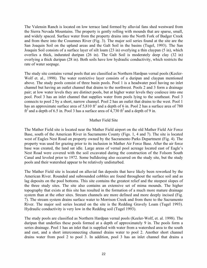
The Valensin Ranch is located on low terrace land formed by alluvial fans shed westward from the Sierra Nevada Mountains. The property is gently rolling with mounds that are sparse, small, and widely spaced. Surface water from the property drains into the North Fork of Badger Creek and from there into the Cosumnes River (Fig. 3). The major soil series found at the site are the San Joaquin Soil on the upland areas and the Galt Soil in the basins (Tugel, 1993). The San Joaquin Soil consists of a surface layer of silt loam (23 in) overlying a thin claypan (5 in), which overlies a thick, indurated duripan (26 in). The Galt Soil is moderately deep clay (32 in) overlying a thick duripan (28 in). Both soils have low hydraulic conductivity, which restricts the rate of water seepage.
The study site contains vernal pools that are classified as Northern Hardpan vernal pools (Keeler-Wolf et. al., 1998). The water restrictive layer consists of a duripan and claypan mentioned above. The study pools consist of three basin pools. Pool 1 is a headwater pool having no inlet channel but having an outlet channel that drains to the northwest. Pools 2 and 3 form a drainage pair; at low water levels they are distinct pools, but at higher water levels they coalesce into one pool. Pool 3 has an inlet channel that supplies water from pools lying to the southeast. Pool 3 connects to pool 2 by a short, narrow channel. Pool 2 has an outlet that drains to the west. Pool 1 has an approximate surface area of 5,810 ft2 and a depth of 6 in. Pool 2 has a surface area of 780 ft2 and a depth of 6.5 in. Pool 3 has a surface area of 4,730 ft2 and a depth of 9 in.
Mather Field Site
The Mather Field site is located near the Mather Field airport on the old Mather Field Air Force Base, south of the American River in Sacramento County (Figs. 1, 4 and 7). The site is located west of Eagles Nest Road on property owned by the Sacramento Parks Department (Fig. 4). The property was used for grazing prior to its inclusion in Mather Air Force Base. After the air force base was created, the land sat idle. Large areas of vernal pool acreage located east of Eagle’s Nest Road were covered with the soil excavated during the construction of the Folsom South Canal and leveled prior to 1972. Some bulldozing also occurred on the study site, but the study pools and their watershed appear to be relatively undisturbed.
The Mather Field site is located on alluvial fan deposits that have likely been reworked by the American River. Rounded and subrounded cobbles are found throughout the surface soil and as lag deposits on the pool bottoms. This site contains the greatest relief and the steepest slopes of the three study sites. The site also contains an extensive set of mima mounds. The higher topography that exists at this site has resulted in the formation of a much more mature drainage system than at the other sites. Stream channels are more defined and more deeply incised (Fig. 7). The stream system drains surface water to Morrison Creek and from there to the Sacramento River. The major soil series located on the site is the Redding Gravely Loam (Tugel 1993). Hydraulic conductivity is very low in the Redding soil (Tugel 1993).
The study pools are classified as Northern Hardpan vernal pools (Keeler-Wolf, et. al. 1998). The duripan that underlies these pools formed at a depth of approximately 9 in. The pools form a series drainage. Pool 1 has an inlet that is supplied with water from a watershed area to the south and east, and a short interconnecting channel drains water to pool 2. Another short channel drains water from pool 2 to pool 3. In addition, pool 3 has an inlet channel that drains a
22

watershed area south of the pool. An outlet from pool 3 drains water to a small swale pool and from there to a stream channel. Pool 1 has an approximate surface area of 5,860 ft2 and a depth of 9 in. Pool 2 has a surface area of 4,830 ft2 and a depth of 11-in. Pool 3 has a surface area of 4,970 ft2 and a depth of 11 in.
Methods
Data Collection
At each study pool, a number of piezometers and neutron access pipes were installed (Figs. 8, 9 and 10). The piezometers consisted of open-bottomed 1” PVC pipes installed in nests of two, three, or four pipes open at different depths. At each study pool, one piezometer nest is installed in the pool center, four nests in the pool margin, and four in the nearby upland areas. The piezometer nests were arranged into two transects, one that roughly parallels the long axis of the vernal pool and the other perpendicular to it. The neutron access pipes consist of open-bottomed 2” PVC pipes that are installed at three locations in each study pool; pool center, pool margin, and nearby upland. Standing water levels in the piezometers and neutron access pipes were measured manually with an electric level sounder approximately weekly during the wet season, until every piezometer and access pipe was dry. The electrical conductivity of all standing water was measured weekly with a YSI Model 30 conductivity meter. Soil moisture was measured weekly with a neutron probe instrument and tensiometers (Gridley Ranch only). Water levels in the vernal pools were continuously measured with an automatic recording pressure transducer and data logger. In addition, pool water levels were measured manually with a staff gage as a backup in case of level logger failure. Precipitation was measured with a 0.01-inch tipping bucket rain gage with an automatic data logger.
Figure 8. Instrumentation layout at Gridley site.
23
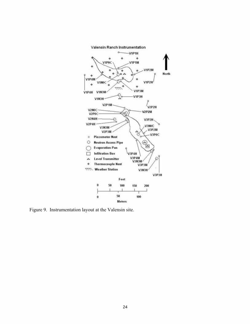
Figure 9. Instrumentation layout at the Valensin site.
24

Figure 10. Instrumentation layout at the Mather site.
Water Balance
The volume of water ponded on the surface (V) in a vernal pool can be equated with the difference between the water inputs and outputs. The inputs include precipitation (P), surface flow into the pool (SFin), and groundwater seepage into the pool (Sin). The outputs that reduce the volume of water in pool storage include evapotranspiration (ET), surface flow out (SFout), and groundwater seepage out of the pool (Sout). The water budget equation is:
∆V = (P + Sin + SFin) – (ET + Sout + SFout)
The change in pool volume (∆V) was calculated from the pool stage data obtained from the level transmitters installed in each study pool. The pool volume and surface area were calculated from survey data made of the study sites. The volume of water required to fill a vernal pool to the overflow level is compared to the volume of water that is supplied to the pool as direct precipitation. Any water in the pool, in excess of the direct precipitation, must be supplied by the watershed. The volume of excess water divided by the total precipitation, provides a measure of the minimum size of watershed support. Surface water flow in and out, and seepage in and out were not directly measured. Precipitation was measured locally at each pool site and reference ET (ETo) was estimated for each site from data obtained from the closest CIMIS station. Pan ET (Etpc) was calculated for each site by multiplying the reference ET value by a pan coefficient. The pan ET value was used to estimate losses from the standing water in pool. For each site, a PET curve was created by
25

adding the daily precipitation (P) and subtracting the daily ET. The PET curve forms a synthetic pool level curve that accounts for changes in vernal pool water levels due only to precipitation and evaporation. The PET curve is a simple visual aid that is compared to actual pool levels as recorded by the level loggers. Significant differences between the PET curve and the actual pool level were evaluated for the relative magnitudes of the seepage and surface flow terms in the water balance. If the analysis is performed between major storms and when the pools are below the overflow levels, then any significant difference between the response of the pool level curve and the PET curve can be attributed solely to the seepage terms in the water balance.
Pool Wet-Up
The water supplied to the vernal pools and the surrounding uplands by the first few rains infiltrates into the soil to meet the soil moisture requirements. Once saturation of the near-surface soil is achieved, the pools begin to pond water on the surface. The amount of precipitation necessary to saturate the soil can be determined from rainfall data. As the pool fills with water the pool increases in volume and surface area. If there is sufficient rain, the pool level will eventually rise until the pool is full and its overflow level is reached. At that point, excess surface water flows out of the pool via its outlet channel. Surface water flow, overland and channel flow, can move large volumes of water quickly through the vernal pool system. In the absence of enhanced flow features such as rodent burrows, fractures or mud cracks, groundwater seepage rates can be expected to be generally low. Thus the rate at which the vernal pool wets up is an indication of how the vernal pool is supplied with water from its watershed. Vernal pools receiving a significant percentage of water from its watershed by groundwater seepage will show a tendency for the pool levels to rise for many hours to days after the cessation of a large storm. Vernal pools that receive most of their watershed contribution from surface flows show a tendency for the pool level to rise quickly and then remain steady or begin falling soon after the cessation of the storm.
Pool Dry-Down
The dry-down phase of the vernal pool provides a good opportunity to determine the magnitude and direction of groundwater seepage from vernal pools. During this portion of the wet season, precipitation events are usually infrequent and small or absent altogether, interconnecting channels are dry, and ET is more significant. The PET curve can again be compared with the pool level curve to highlight significant differences. If the pool level follows the PET curve, then ET forms the only significant output and groundwater seepage inflow and outflow are negligible. If pool level drops slower than the PET curve, then groundwater seepage is supplying water to the vernal pools maintaining pool levels. If pool levels drop faster than the ET curve, then groundwater seepage is drawing water from the pools. The difference between the ET losses and the pool level losses provide an estimate of the seepage rate.
26

Groundwater
Water levels recorded in the piezometers provide a measure of the hydraulic head at the time of measurement. Elevations of the groundwater levels (hydraulic head) are compared against each other and the pool water level to provide a measure of the direction and magnitude of the hydraulic gradients that drive vertical and horizontal groundwater flow. How those gradients change over the wet season provides an indication of the relative importance of watershed contributions and losses throughout the wet season.
Soil Moisture
A neutron probe instrument provides a measure of the volume-averaged soil moisture that exists at predetermined depths. The depths chosen for the measurements were 0.5, 1, 2, 3, 4, 5, 6, 7, and 8 ft below ground surface. These depths were chosen to measure the soil moisture content to a depth well below the duripan/claypan that may support the formation of a perched water table. In addition, at the Gridley Ranch site, five tensiometers for measuring soil-water pressure (and, in turn, hydraulic head in the unsaturated zone) were installed at each study pool in an equally spaced transect from the pool margin to the nearest highland.
Pool Water Conductivity
Electrical conductivity (EC) is a measure of the concentration of dissolved ions present in the water. The electrical conductivity of all standing water (pools, piezometers, neutron access pipes) was measured to track changes in the concentration of dissolved ions. A vernal pool that undergoes only ET losses would be expected to show a rapidly increasing conductivity as the pool approaches dry-down. The value of expected evapoconcentration of the ions dissolved in the pool water is compared to the actual value in conductivity. Large deviations in the conductivity from the expected value provide evidence that groundwater seepage is responsible for some of the losses of pool water volume, i.e. groundwater seepage is carrying dissolved ions away from the shrinking volume of pool water.
Rainwater has few dissolved ions and thus has a low value for EC. Pool water that is composed mostly of direct precipitation will tend to have low values of EC. Surface water in the drainage system can pick up dissolved ions and will have a higher value of EC than direct precipitation. Groundwater typically contains higher amount of dissolved ions, which results in a higher value for EC measured in the piezometers. The concentration of dissolved ions in the groundwater tends to increase with longer residence time and with deeper depth in the soil profile. Groundwater that can move quickly through the shallow groundwater environment tends to pick up less dissolved mass. Vernal pools that receive significant inflows of groundwater may show higher concentrations of dissolved ions introduced from the watershed soils. Not only does EC provide an indication of groundwater seepage out of the vernal pool, it also provides an indication of seepage into the vernal pool and the level of mixing with direct precipitation. A detailed analysis of the changes in water chemistry of the vernal pools that occur over the wet season can be found in the enclosed paper by Rains et al. (in press).
27

Surface Water Observations
Each site was visited throughout the year to allow the collection of manual data. During the wet season the visits were approximately weekly until the pool water and the perched water table were completely gone (i.e. no standing water in any piezometer or neutron access pipe). During the summer the visits were less often, approximately monthly, to establish baselines for soil moisture and to maintain instrumentation. These visits provided an opportunity to directly observe and photograph the progress of the vernal pool over its complete wet-up and dry-down cycle. These direct observations were made over a total of three years, from 2001 to 2004.
Results
Water Balance
The total precipitation that fell each season at each site is listed in Table 1. The average values of precipitation for the Sacramento area are approximately 18 inches per year. Thus the precipitation totals for the first two seasons are about normal, while the 2003-2004 season received below normal precipitation. The first few inches of precipitation that fall at the beginning of the wet season go to satisfy soil moisture requirements. The soil moisture requirements are determined by a number of factors including the soil porosity, depth of the soil overlying any impeding layer, and the hydraulic conductivity of the soil that controls the rates of infiltration and groundwater seepage to deeper formations. After the soil moisture requirements are satisfied, additional precipitation begins to fill the pool bottoms and other low areas in the surrounding topography. The water stored in the vernal pool is derived from two sources, a contribution from direct precipitation and a contribution derived from the watershed as surface runoff and/or groundwater flow. The watershed contribution calculated for some of the pools are listed in Table 2. The volume of water contained in each vernal pool when full, divided by the surface area of the pool bottom provide a measure of the amount of precipitation that would be required to completely fill the pools (see “Precipitation Needed” in Table 2). The onset of ponding and time at which the pool becomes full are easily determined from the pool water level logger data. The amount of precipitation that fell between the onset of ponding and the time the pool becomes full is shown in the second column of Table 2 (“Actual Precipitation”). The watershed contribution (column 3) is the difference between the amount of precipitation from all sources required to fill the pool (column 1) and the contribution from direct precipitation (column 2). The percentage of water stored in the pool volume derived from the watershed is shown in column 4. This table shows that the watershed contribution forms a significant percentage of the total volume of water initially stored in the vernal pool.
28

Table 2 Watershed Contributions
Precipitation Needed (in)
Actual Precipitation (in)
Watershed Contribution (in)
Watershed Contribution (%)
Gridley Ranch Pool1 5.06 2.23 2.83 56 Pool2 5.36 2.23 3.13 58
Valensin Ranch
Pool1 2.06 1.14 0.92 45 Pool2 Pool3
Mather Field
Pool2 2.37 1.96 0.41 17 Pool3 2.55 1.96 0.59 23
29
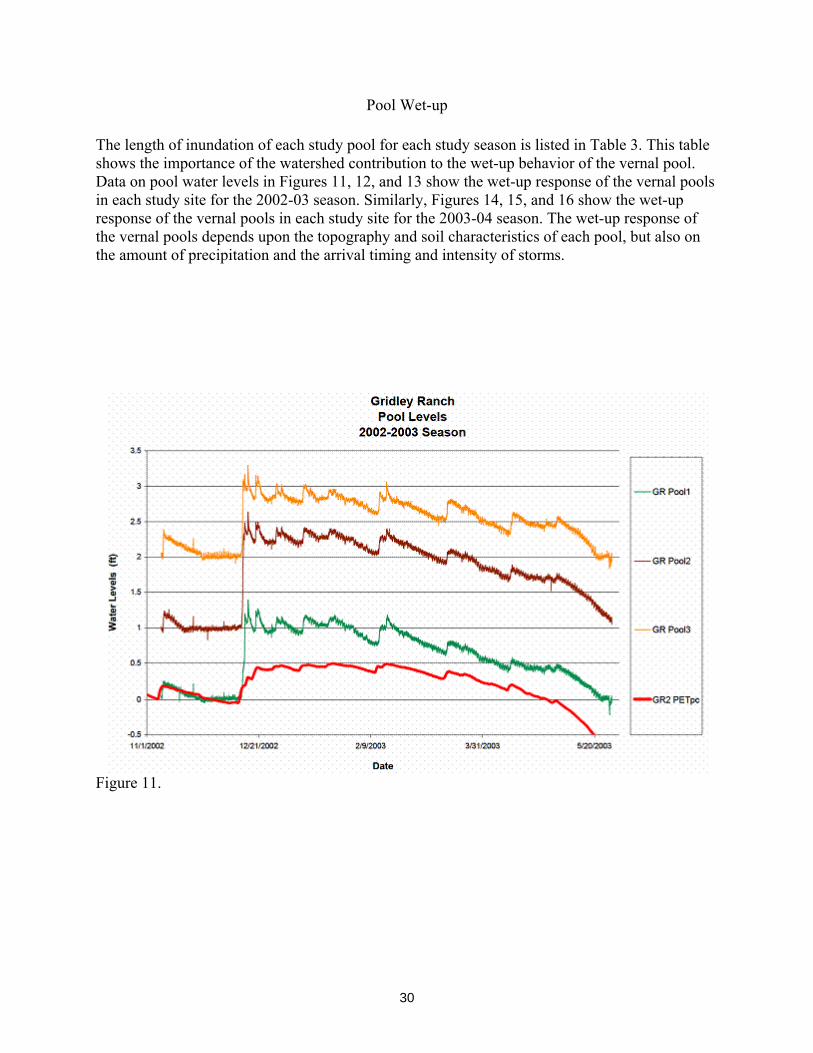
Pool Wet-up
The length of inundation of each study pool for each study season is listed in Table 3. This table shows the importance of the watershed contribution to the wet-up behavior of the vernal pool. Data on pool water levels in Figures 11, 12, and 13 show the wet-up response of the vernal pools in each study site for the 2002-03 season. Similarly, Figures 14, 15, and 16 show the wet-up response of the vernal pools in each study site for the 2003-04 season. The wet-up response of the vernal pools depends upon the topography and soil characteristics of each pool, but also on the amount of precipitation and the arrival timing and intensity of storms.
Figure 11.
30

Figure 12.
Figure 13.
31

Pool Dry-down
Pool water level data in Figures 11, 12, and 13 show the dry-down response of the vernal pools at each study site for the 2002-03 season. Similarly, Figures 14, 15, and 16 show the dry-down response of the vernal pools at each study site for the 2003-04 season. The PET curve is superimposed over one of the pool level curves. When the trends of the pool water levels deviate from the trend of the PET curve, in the absence of surface water flow, net losses or gains are due only to groundwater or vadose water seepage. The difference between these trends provides an indication of the direction and rate of groundwater seepage.
Groundwater
The groundwater behavior through the wet season is shown in Figures 17, 18, and 19.
Soil Moisture
The soil moisture content is shown in Figures 20, 21 and 22. This soil moisture response is highly dependent upon soil type and soil depth.
Pool Water Conductivity
The electrical conductivity of the pool water at each study site is shown in Figures 23, 24 and 25. The electrical conductivity of the pool water varies significantly among the study sites.
Surface Observations
The topography of the study sites can be seen in Figures 2, 3, and 4. The general layout of the pools, the distance between the pools, the length and maturity of the drainage systems can be seen in the aerial photos of the study sites (Figs. 5, 6 and 7).
32

Figure 14.
Figure 15.
33

Figure 16.
Figure 17.
34

Figure 18.
Figure 19.
35

Figure 20.
Figure 21.
36

Figure 22.
Figure 23.
37

Figure 24.
Figure 25.
38

Discussion
Gridley Ranch The Gridley Ranch site received an average of 16.3 inches of rain over the three seasons of this study (Table 1). This rain arrived as a series of storms beginning in October or November. The water derived from the first few storms infiltrates into the soil, satisfying the soil moisture requirements. The soil moisture requirements at Gridley Ranch are the smallest of the three sites, requiring less than 3 in of precipitation before substantial ponding begins. The impeding layer in the Solano-Pescadero soils is a shallow clay layer approximately 9 in deep in the pool bottoms. The hydraulic conductivity (K) of the surface soil itself is also very low. One of the results of the low-K surface soil is that the pools at the Gridley Ranch can begin ponding water immediately. For example the very first rain in the second season resulted in water ponding in the pool bottoms for two weeks. Water balance calculations show that the vernal pools at Gridley Ranch require the most water to fill, from 5 to 5.5 in of direct precipitation. Since 5-in rainstorms are very rare events, the pools fill from a combination of direct precipitation and watershed contributions. In the second season, the volume of water that accumulated in the vernal pools during and after the initial wet-up storm was over twice the amount of precipitation that fell directly into the pool. Thus a watershed that is at least the same size as the pool is necessary to supply the additional volume of water stored in the pool. The wet-up behavior of the vernal pools shows that the pools fill to overflowing in a very short time (within hours). Since the Gridley Ranch study site has a very gentle slope with little relief and the Solano-Pescadero soils have very low hydraulic conductivity, the excess water in the vernal pool (above the volume of direct precipitation) arrived mainly as surface water. The interconnecting channels at this site are long, broad, and shallow. They fill with water quickly and drain a large watershed area between the vernal pools (Fig. 2). Once the upstream pools fill to the overflow level, the channels begin to deliver the water spilled from upstream pools into down stream pools. However, Figure 11 shows that all three vernal pools in the study fill at nearly the same rate. Thus the overflow from upstream pools does not contribute much to the storage in downstream pools.
The Pescadero-Solano complex is composed of clays and clay loams with very low K values. The K value is too low, topography too subdued, and distances between pools too great to allow a significant movement of groundwater between pools. Accordingly, little infiltration of precipitation occurs, thereby reducing the soil moisture requirements necessary to promote ponding. The Gridley Ranch requires the least amount of precipitation to begin ponding, less than 3 in. Figure 11 shows that infiltration is so slow that water ponded immediately on the surface at the beginning of season 2002-03 due to a heavy rain at the beginning of the wet season. Then over the next 2 weeks the water was lost due to a combination of evapotranspiration and infiltration. The watershed in this initial case has not contributed much to the pool level, as almost all of this water level can be attributed to rain on pool. When the large wet-up storm arrived on 12/13/2002, the pools filled very quickly to overflowing. The entire watershed was observed over three seasons to become soaked by the first large storm. Low spots in the topography ponded water and the entire watershed became swampy. It was
39

obvious that little precipitation infiltrated and that large volumes of water were flowing through the drainage system. Large areas of the watershed remained swampy for many weeks, and the drainage channels contained some water for months. The dry-down behavior of the vernal pools at Gridley Ranch is very different than the pools at the other sites. Figure 14 shows the pool level curve and the PET curve. This graph shows that the pool level after 3/1/04 falls at the same rate as the pan evaporation rate. Thus all of the water loss from the pool can be attributed to ET. During this period the rate of groundwater seepage is essentially zero. The piezometer data show that some water is getting below the impeding layer, but this process takes about four weeks before standing water is measured in many of the 3-ft piezometers. The water levels measured in the piezometers throughout the wet season are always lower than pool level. Thus the hydraulic gradients are downward and almost always have a value greater than unity. Electrical conductivity of the pool water at the Gridley Ranch shows the characteristic behavior of water bodies undergoing evaporation. Figure 23 shows that the pool water EC gradually increases as the pool level drops but then increases rapidly as the pool approaches total dry-down. Thus the dissolved ions in the water are not being removed to any significant degree by groundwater seepage. The conceptual model that emerges from a study of the data obtained from the Gridley Ranch over three wet seasons is the surface ponding model. In this model, the surface soil is composed of very low-K materials. A duripan or claypan may exist at some depth, but it does not form the primary impeding layer. Since the majority of precipitation remains on the surface, the soil moisture requirements are lower than other models. The soil moisture may gradually increase with time as the groundwater seepage provides water to the duripan or claypan, possibly forming a secondary, perched water table. The soil column between the surface and any perched water tables would not be saturated and would remain at or near field capacity throughout the wet season.
Valensin Ranch
Valensin Ranch received on average 17.3 in of rain over the three wet seasons of the study (Table 1). Again, the water from the first few storms infiltrates into the soil to meet the soil moisture requirements. At the Valensin Ranch site the soil moisture requirements are the largest of the three sites, requiring 4.5 to 5.5 in of precipitation before ponding begins in the pool bottoms. The thickness of soil overlying the impeding layer in the Galt – San Joaquin soils is deeper than the other two sites, from 2 to 3 ft thick. As a result, the pools at Valensin Ranch begin ponding water almost a week later than either of the other sites. Not only are the vernal pools at the Valensin Ranch the last to wet-up, but they are also the first to dry down (Table 3). The water balance analysis indicates that once the soil moisture requirements are met the vernal pools at Valensin Ranch require 2 – 2.3 inches of precipitation to fill the pool to the overflow level. This volume of water can arrive as direct precipitation from a single large storm or as a combination of direct precipitation and watershed contributions from one medium storm or a series of small storms. In both the second and third seasons, no single large storm arrived. Consequently the wet-up of the vernal pools resulted from the accumulation of water from a
40

series of small storms over several days. The amount of direct precipitation that accumulated from these storms was insufficient to fill the vernal pools. The watershed supplied the excess water needed to fill the pools. In season 2002-03, the watershed contribution was 45 to 47% of the total volume of water in the vernal pools (Table 2). The wetting behavior of the vernal pools, as recorded on the automatic level loggers, suggests that the extra water arrived during or shortly after the storm events (within a few hours). Since the pool complex is located on land with gently rolling topography and the San Joaquin and Galt soils have low K values; the excess water arrives in the vernal pool too quickly to be the result of significant groundwater flow. Thus the watershed contributes at least 45 percent of the initial wet-up volume of water into the vernal pool, and most of that is the result of surface water processes. The watershed contribution can form an important source of water for the initial pool wet-up and is especially important to headwater pools. In season 2002-03, Pool 1 (a headwater pool) began ponding water at the same time as the other study pools but never received enough water to fill the pool to the overflow. While Pool 2 and 3, which form a drainage series with other upstream pools, filled to the overflow level and contained standing water for six weeks. In the absence of the watershed contribution, the time required to fill the pools would have increased by over three weeks. In season 2003-04, all pools filled to the margin, but again the loss of the watershed contribution would increase the time from the beginning of ponding to margin full by nearly a month. The difference in the wet-up behavior is linked to the size and timing of storm arrival. In season 2003-04, the initial wet-up storm provided twice the volume of water as the initial wet-up storm in season 2002-03. Clearly, in the absence of large wet-up storms, alteration of surface drainage would result in later filling of the pools or could even result in a failure to pond in drier years. Figure 15 shows that the pool water level lowered continuously after the initial wet-up in both seasons, even though the ET losses were nearly zero. Some of the loss at higher pool levels may be attributed to overflow losses to the outlet. However, the pool level continued to fall at roughly the same rate down to a zero level. This loss of water, especially at lower pool levels and in the absence of significant ET, can only be the result of groundwater seepage losses from the pool. Comparing the pool water level curve to the PET curve provides a means of calculating the groundwater seepage that is occurring. For the period of 3/5/2004 to 3/11/2004 in season 2003-04, the groundwater seepage loss was calculated to be 0.002 ft/day. Few of the piezometers at the Valensin Ranch contained any standing water. The only piezometers that showed consistent standing water were the 2-ft piezometers on the margin of Pool 1 (west, east, and south piezometers) and the 2-ft piezometers on the highlands at the extreme east edge of the study site. The water levels in the piezometers on the margin of Pool 1 are always lower than the level of the pool. Thus the groundwater gradient is downward, away from the pool. This confirms that the groundwater seepage results in a net loss of water from the vernal pools. All the remaining piezometers show that the impeding layer and the soils beneath it do not saturate. The soil moisture data obtained from the neutron probe show that the pool bottom soils saturate above the hardpan and stay saturated at least as long as standing water remains in the pools. In season 2002-03, standing water was present for only six weeks in Pool 2 and 3, yet the near
41

surface pool bottom soil stayed near saturation for almost five months. In Pool 1, standing water was not present in the pool bottom for more than a week, yet the pool bottom stayed saturated for the same five months. The highland soils never reached saturation, and over the course of the same five months, soil moisture levels declined as the soil moisture drained away. Late in the dry-down, the watershed surrounding the vernal pool is drawing water from the pool to replace moisture lost due to a combination of groundwater seepage and enhanced ET. As the volume of water in the vernal pool is reduced by ET loses, the electrical conductivity of the water should rise rapidly as the pool dries out (Figure 24). This behavior is not generally observed at Valensin, which indicates that water is being lost to groundwater seepage and this seepage is carrying some fraction of the total dissolved ions away from the pool. Since the electrical conductivity of groundwater is about six times greater than the conductivity of the pool water, any groundwater seepage into the pool would also tend to increase the electrical conductivity over time. This effect is also not observed, suggesting that groundwater seepage into the vernal pools is either not occurring or is insignificant. The conceptual model that emerges from the study of the Valensin Ranch is the mounding vernal pool model. In this model the vernal pool itself is the source of water to the watershed. The watershed provides water to the pool predominately as a result of surface water processes. The pool stores the water, but constantly loses water as a result of vertical and horizontal seepage. The highland soils approach saturation with the initial wet-up but then lose soil moisture slowly over the time period that water is ponded in the pool bottoms. Clearly, Pool 2 and 3 develop as one perched groundwater system since they are in close proximity and may be viewed as one pool. Pool 1 is a headwater pool that apparently forms its own perched system.
Mather Field Mather Field received an average of 18.3 in of rain over the three seasons of the study (Table 1). At Mather Field the soil moisture requires 4.3 to almost 7 in of precipitation before ponding begins in the pool bottoms. Variability in the soil moisture requirements from season to season depends on the rate of ET, the size and frequency of storm arrival, and the rate of groundwater seepage draining the upland areas. The water balance calculations show that the vernal pools at Mather Field require approximately 2.3 inches of precipitation to fill the pools to the margin full level. This volume of water can arrive as direct precipitation alone or with a watershed contribution. At Mather Field the slope of the surrounding watershed and soil hydraulic conductivity are large enough to allow significant groundwater seepage. In season 2002-03, the wet-up storm delivered only half the water needed to fill the pools. The pool water levels continued to rise for a week after the storm, eventually filling the pools from the watershed contribution. In season 2003-04, the wet-up storm arrived again but only filled the pools half way. Before the watershed contribution could fill the pools, however, another storm arrived and filled the pools to overflowing. The subsequent drainage from the watershed, both surface flow and groundwater seepage into the vernal pools, was lost as overflow and groundwater seepage out of the pools.
42

Figure 16 shows the pool water level in season 2003-04 with the PET curve superimposed. When ET losses are very low, the pool levels remain nearly steady for many weeks. As subsequent storms provide water to the pool and watershed, little change in the pool water level results. Groundwater seepage into the vernal pools continues as excess groundwater in the upland soils, above field capacity drains toward the pools. Since surface overflows from the vernal pools were not observed, groundwater seepage out of the pools is maintaining pool levels nearly constant. When ET losses begin to increase in early March, the pools lose water faster than can be explained by ET. By this time, surface water flows have stopped. The neutron probe data shows that the highland soils are drying rapidly. As the dry-down proceeds, the rate of loss from the vernal pools increase as the surrounding watershed begins to draw water from the vernal pools to maintain soil moisture levels in the margin areas. Our work published in Rains et. al. (in press) proposed the “flow through” conceptual model for the vernal pools at Mather Field based on the analysis of groundwater chemistry and heads in the shallow piezometers. In this conceptual model groundwater enters the vernal pool on one side and leaves from another. A duripan or claypan forms an impeding layer that forms an apparently regional-scale perched aquifer the controls much of the Mather pool hydrology. We further stated that the majority of groundwater flows under or around the vernal pools.
The topography at Mather Field consists of small watershed areas, which slopes toward the vernal pools with a grade of 2%, providing ample potential for horizontal groundwater gradients. While the outflow from the vernal pools may take the form of groundwater seepage, the model does not preclude losing water from the pool due to surface drainage. The loss of dissolved ions in either case would be the same. The groundwater heads, measured in the piezometers in the upland areas to the east and south of the vernal pools, are higher than the water level in the pools. This difference in head provides the horizontal driving force necessary to support the groundwater seepage into the pools from these watershed areas.
The electrical conductivity of the pool water at Mather Field does not show effects of evapoconcentration. Pool water EC shows little tendency to evapoconcentrate dissolved ions. In the case of a flow through vernal pool, dissolved ions may be introduced to the pool water by groundwater seepage into the pool and removed by groundwater seepage out of the pool. It is expected that the pool water should show a rise in EC over the course of the wet season as higher EC water is supplied by groundwater seepage from the watershed and lower EC water is removed by groundwater seepage out of the pools. The pool water EC does tend to increase slightly as the wet season progresses, but this trend in slight.
Vernal Pool Variability Prior researchers have noted that many different combinations of climate, geology, topography, soils, biota, and hydrology combine to create and support vernal pools. These vernal pools may appear on the surface to be very similar, yet may exhibit very different hydrologic behavior. The selection of the vernal pool complexes in this study was intended to highlight differences in three of these factors: topography, soils, and hydrology. As noted above, significant differences in the hydrology exist between the vernal pools at the study sites. Even individual pools within a study
43

site demonstrate differences in hydrologic behavior. These behaviors appear to form a continuum, with the Gridley Ranch forming one end member and Mather Field the other. The Valensin Ranch appears to fall somewhere in the middle. For instance the vernal pools at Valensin Ranch behave like the pools at Gridley Ranch during wet-up and like the pools at Mather Field during dry-down. Whether other vernal pools fall in this continuum is a topic for future research. Pool Size and Soils The Gridley Ranch formed larger, deeper pools. Since the clay soils at Gridley Ranch keep the vast majority of water on or near the surface, only larger, deeper pools can maintain standing water long enough to support a large population of vernal pool species. Smaller, shallower pools exposed to ET losses dry-down much faster, limiting the number and type of vernal pool species that can exist within the pools. Mather Field formed a larger variety of pool sizes. Unlike Gridley Ranch, smaller and shallower pools can be maintained at Mather Field. The gravelly loam surface soils overlying a shallow duripan and topography combine to support a semi-regional-scale perched aquifer that maintains pool levels against ET losses and regulates the groundwater chemistry. Topography and Hydraulic Conductivity The pools at Gridley Ranch receive nearly all their water from a combination of direct precipitation and surface water inflows. Groundwater seepage into the pools, if it exists at all, is so slow that it cannot provide sufficient water to replace even minor ET losses. The water stored in the pool volume is maintained by surface water flow, which may continue for many days to several weeks after a large storm. The topography of the site is important, as gentle slopes and a poorly developed drainage system prevent rapid runoff of excess surface water. At Mather Field, the topography is also important, but in a different way. The watershed areas, surrounding the pools, slope toward the pools. This slope is critical in developing large enough horizontal gradients to move a significant amount of groundwater from the watershed into the vernal pools between storms, maintaining a steady pool level in spite of ET and groundwater seepage losses.
Implications for Managing Vernal Pools Landscapes The implications of the observed variability in vernal pool processes can be very different depending upon which factors are critical to a given vernal pool type. The “surface ponding” model of vernal pools, for which Gridley Ranch is the example, does not depend upon groundwater to maintain pool levels. Direct precipitation and surface water flows are the major sources of water to the vernal pools. Interconnectivity of the pools within the complex is due entirely to the surface water drainage system. This type of vernal pool would mostly be impacted by activities that alter the surface water hydrology of the vernal pool complex. Watershed truncation and drainage system alteration or truncation are the most likely activities to impact this type of vernal pool. Engineered remediation solutions that maintain drainage system integrity, vernal pool interconnectivity, and that prevent the introduction of excessive or unnatural nutrients or contaminants to the vernal pool system are likely to limit or eliminate unfavorable impacts. Activities that alter the subsurface are likely not important, except immediately adjacent to the vernal pool margin. The activities that are likely to have a
44
detrimental impact are those that increase subsurface from the vernal pools, such as the installation of drains. The “perched aquifer” model of vernal pools, for which Mather Field is the example, depends upon inflows of groundwater between major storms to maintain nearly constant pool levels. Direct precipitation, surface water flows, and groundwater seepage are all major sources of water to these vernal pools. The vernal pools are interconnected by the surface water drainage system and by the groundwater system. The groundwater interconnectivity is most likely the result of a continuous perched aquifer that is supported by the duripan found in these soils. This type of vernal pool is also susceptible to impacts that alter the surface water drainage. The same considerations must be given to maintaining surface water connectivity and limiting the introduction of nutrients or contaminants. In addition, this type of vernal pool is also likely to be impacted by activities that alter the subsurface. This type of vernal pool is much more dependent upon the adjacent watershed to maintain pool levels. Watershed truncation could result in slower wet-up and faster dry-down. It could also eliminate the interconnectivity of the vernal pools and reduce or eliminate groundwater seepage out of the pool. This could have negative impacts on the vernal pool biota if the natural flushing of nutrients and solutes from the pool water is interrupted. Engineered remediation would likely be more difficult, as this type of vernal pool will require much more study to determine the nature of the groundwater system and design appropriate solutions to reduce likely impacts.
Recommendations for Future Work
The viability in the behavior of the vernal pools that has been demonstrated in this study is a result of differences in the six factors described above that are important to vernal pool formation and maintenance. The many possible combinations of these factors create a vast array of potential vernal pool environments, some of which exist and some of which may not. More research is needed to (1) identify the range in the factors that combine to form vernal pools, (2) identify and quantify the necessary and sufficient conditions required for a given vernal pool model, (3) determine how much these conditions can be modified without adversely altering the vernal pool environment (4) determine which engineered remediation solutions are practical and effective for a given pool type, and (5) determine the type and amount of data that must be collected to determine the factors that may be critical to vernal pool survival.
Conclusions
Direct precipitation could potentially fill any of the vernal pools in the study areas if sufficiently large storms arrive early in the wet season. During the three wet seasons studied in this project, none of the vernal pools initially filled due only to direct precipitation. In all cases, the greater watershed supplied 25 to 60% of the water necessary to fill the vernal pools to the margin. Clearly, the relative size of the watershed contribution is dependent upon the size and arrival timing of the storms at the beginning of the wet season. Depending upon the topography and soil properties, the watershed contribution arrives as some combination of surface water flow and groundwater seepage. In cases where the topography is flat or gently rolling and the soil K value is low, surface water flow is the predominate source of the watershed contribution. The
45

groundwater seepage in these cases can be so small as to be negligible. In cases where there is some watershed area sloping toward the pools and the soil K is moderately high, groundwater seepage can deliver measurable amounts of water to the pool volume. In this case surface water flow could also deliver significant amounts of water to the pool volume. The difference between these sources is most obvious in the timing of the arrival of the watershed contribution to the pool volume. Surface water flow delivers water to the vernal pool relatively quickly, during and shortly after the storm (usually within a few hours). Groundwater seepage is slower, delivering water to the vernal pool over the course of several days to a week or more. The wet-up behavior of the study pools within each vernal pool complex was very similar. After the soil moisture requirements were satisfied, the vernal pools began to pond water. If enough water was supplied to the vernal pool, the pool level reached its overflow level and spilled water to its outlet channel. The water spilled from upstream pools may be delivered by the drainage system to downstream pools. However, the vernal pools in a study area all began to pond water about the same time and reach their overflow levels at nearly the same time. Thus the water delivered to the pool via the inlet channel from an upstream pool usually reaches the downstream pool when it is already full or nearly full. Thus the contribution spilled from upstream vernal pools does not generally add much water to the pool volume of downstream pools but flows through the pools to their outlets. The effect on the hydrology of vernal pools due to watershed truncation depends greatly upon what is being lost. In all cases reported in this study, some watershed contribution is supplied to the vernal pools. The loss of part or all of the watershed contribution during the initial wet-up results in a delay in filling the vernal pool. If the watershed is truncated (e.g., road construction), the vernal pool will have to accumulate more direct precipitation to fill the pool to the margin. Depending on the size and arrival frequency of storms, this could delay the filling of the vernal pool from several days to over a month, or could even result in a failure of the vernal pool to fill altogether. This delay in filling the vernal pool would likely reduce the length of inundation for portions of the vernal pool environment. Among other possible effects, such reductions could possibly result in a shrinkage in the size of the vernal pool as the biota shifts closer to the pool center in response to lower pool levels and drier soil moisture conditions. The watershed areas most critical to the vernal pool hydrology are the watershed areas on both sides of the inlet channel. Since overland flow has only been observed at the Gridley Ranch, and then only after large storms, the inlet channel is the source of the majority of the watershed contribution. A truncation of the inlet channel or the watershed areas nearest to the inlet channel would have the greatest effect on the volume of water supplied to the vernal pool. Since upstream vernal pools fill to the overflow at nearly the same rate as the downstream pools, the loss of the upstream vernal pool may not have a major impact on the hydrology of downstream pools. Some vernal pools are the surface expression of a perched water table (e.g., the Mather Field vernal pools). Perched water tables are seasonal and are created by the accumulation of precipitation on top of a low-K layer in the soil. These perched water tables may exist for a number of months, but usually completely dry out by late summer. The impeding layer can exist in a number of forms, including a clay layer, duripan, paleosol, bedrock, or some combination of
46

these. Generally, these impeding layers are shallow (3 ft or less below ground surface) and the volume of groundwater that can be stored in them is limited. In addition, the impeding layer may be thin or missing in some areas or contain holes, cracks, and burrows. The lateral connectivity of perched water tables is limited by the thickness and the hydraulic conductivity of the soil overlying the impeding layer and by the distance between the vernal pools. Vernal pool sites with little relief, low K soils, and long distances between vernal pools have little possibility of moving much water between them by groundwater seepage. After the surface soil saturates, excess water accumulates in the vernal pools until they are full. Since groundwater seepage is so slow, the vast majority of the excess water flows through the vernal pool drainage system as surface water. In this case, each vernal pool develops a perched water table centered on the vernal pool. Neutron probe data shows that the soils in the upland areas approach saturation with the initial wet-up storm sequence, but then begin a slow dry-down for the rest of the wet season (in spite of later precipitation). While the soil thickness overlying the impeding layer is generally greater in the upland areas, the saturated thickness of these soils is very small. When the rate of ET increases in the late spring, the remaining soil moisture is lost very quickly. Vernal pool sites with (1) sloping watershed areas that drain toward the vernal pools, (2) moderate or high K soils, and (3) short distances between pools may develop a common perched water table or may develop hydraulic connections through the groundwater between the perched water tables of individual vernal pools.
Vernal pools rarely occur separately, they are most often found in vernal pool complexes. The pools in these complexes are interconnected by a surface water drainage system and sometimes by a groundwater system due to a perched aquifer. This perched aquifer requires an impeding layer to limit the rate at which infiltrating precipitation seeps to deeper formations. The nature of this impeding layer is different in each case. At Gridley Ranch the soil itself is the impeding layer, ponding water on the surface. The pools show no evidence of groundwater seepage, either into or out of the pools. At Valensin Ranch and Mather Field, the impeding layer is a duripan. These duripans are leaky, resulting in measurable seepage losses from the pool volume. At Valensin Ranch, no interconnectivity between the pools appears to exist. At Mather Field, interconnectivity is significant. The difference between these two cases is due to the soil type and the topography. Mather Field has a surface soil with a moderate K and 2% slope, which create a horizontal gradient sufficient to drive groundwater seepage into the pools. At Valensin Ranch there is a low K surface soil and subdued slopes, resulting less potential for forming horizontal gradients sufficient to cause groundwater movement.
The vernal pools included in this study demonstrate markedly different hydrologic behaviors. The variation in these behaviors is due to the variation in the factors that combine to support the vernal pools. How the vernal pools behave have important implications for land use practices and for impact remediation efforts.
References
Bates, L.A. 1977. Soil Survey of Solano County, California. US Department of Agriculture, Soil Conservation Service. Keeler-Wolf, T., D.R. Elam, K. Lewis, and S.A. Flint. 1998. California Vernal Pool Assessment Preliminary Report. The Resources Agency, California Department of Fish and Game.
47

Rains, M. C., G. E. Fogg, T. Harter, R. A. Dahlgren, and R. J. Williamson. in press. The role of perched aquifers in hydrological connectivity and biogeochemical processes in vernal pool landscapes. Hydrological Processes. Tugel, A.J. 1993. Soil survey of Sacramento County, California. US Department of Agriculture, Soil Conservation Service.
48

49
Appendix Rains, M. C., G. E. Fogg, T. Harter, R.A. Dahlgren, and R. J. Williamson. in press. The role of perched aquifers in hydrological connectivity and biogeochemical processes in vernal pool landscapes. Hydrological Processes.
50

Rains et al., VERNAL POOL HYDROLOGY & BIOGEOCHEMISTRY
HYDROLOGICAL AND BIOGEOCHEMICAL CONNECTIVITY
BETWEEN UPLANDS, VERNAL POOLS, AND A SEASONAL STREAM,
CENTRAL VALLEY, CALIFORNIA
1
2
3
4
5
6
7
8
9
10
11
12
13
14
15
16
17
18
19
20
21
22
23
Mark Cable Rains1, Graham E. Fogg2, Thomas Harter2, Randy A. Dahlgren2, and Robert J.
Williamson2
1Department of Geology, University of South Florida, Tampa, FL, 33620
2Department of Land, Air, and Water Resources, University of California, Davis, CA, 95616
Abstract. Vernal pools are depressional features that are inundated for portions of the wet
season, then drain and dry in the late wet and early dry seasons. Endemism and rarity typify
vernal pool biota. Vernal pool biota are sensitive to variations in numerous physical and
chemical hydrological parameters, and it is therefore surprising that few studies of vernal pool
hydrology have been conducted. This study was focused on vernal pools having a claypan
overlying a duripan, perhaps the most common type of vernal pool in the Central Valley of
California. This study was conducted on three vernal pools connected by swales to a seasonal
stream. The vernal pools are surface water components of a seasonal, perched surface water and
groundwater system, and the uplands, vernal pools, and seasonal stream are hydrologically
connected at the catchment scale through surface and subsurface pathways. At the pool scale,
the biogeochemical function of an individual vernal pool is easily quantified since it is clear that
nutrients are cycled and dissolved organic carbon is produced. At the catchment scale, however,
1
Rains et al., VERNAL POOL HYDROLOGY & BIOGEOCHEMISTRY
1
2
3
4
5
6
7
8
9
10
11
12
13
14
15
16
17
18
19
20
21
22
23
the biogeochemical function of an individual pool is not easily quantified because it is equally
clear that groundwater discharge from the uplands dominates the outlet swale water. In this case,
most of the catchment area contributing to the outlet swale is upland, so upland biogeochemical
processes might be expected to dominate the outlet swale water. In other cases, however, most
of the catchment area contributing to the outlet is vernal pool, so vernal pool biogeochemical
processes might be expected dominate the outlet swale water. These findings are relevant in
light of the U.S. Supreme Court’s recent ruling that federal regulators exceeded their statutory
authority by asserting Clean Water Act jurisdiction over isolated waters and the subsequent
debate over the technical definition of isolated waters. These findings also are relevant to current
efforts to preserve and restore vernal pools because land-use changes in vernal pool landscapes
may have significant consequences for vernal pools and streams even if little to no vernal pool or
stream acreage is directly affected.
Keywords: dissolved organic carbon; claypan; duripan; nitrogen; perched surface water and
groundwater; phosphorus; vernal pools
INTRODUCTION
Vernal pools and swales are depressional features that are inundated for portions of the
wet season, then drain and dry in the late wet and early dry seasons. They occur as small,
poorly-drained depressions perched above an impermeable or very slowly permeable soil
horizon or bedrock (Smith and Verrill 1998). These wetlands typically range in size from 50 m2
to 5000 m2 (Mitsch and Gosselink 2000), with some functioning pools being as small as 30 m2
(Hobson and Dahlgren 1998). Vernal pools usually have maximum water depths less than 1.0 m.
2

Rains et al., VERNAL POOL HYDROLOGY & BIOGEOCHEMISTRY
1
2
3
4
5
6
7
8
9
10
11
12
13
14
15
16
17
18
19
20
21
22
23
They represent small yet complete ecosystems that are aquatic islands surrounded by uplands
(Stebbins 1976). Vernal pools occur in southern Oregon, northern Baja California, throughout
California, and in other Mediterranean-type climates of the world (Riefner and Pryor 1996).
Vernal pools are best known for the biological functions that they perform. Vernal pools
are among the last remaining California ecosystems still typically dominated by native flora
(Barbour et al. 1993). Many vernal pool floral and macroinvertebrate species are endemic, and
some vernal pool floral and macroinvertebrate species are federally-listed threatened and
endangered species and/or state-listed endangered and rare species (Holland and Jain 1988,
Keeley and Zedler 1998). Thus, vernal pools are critical components of regional biological
conservation efforts. However, vernal pools are rapidly being lost to agricultural or urban land
uses. For example, estimates based on soil maps, the presence of relict vernal pools, and
inference suggest that 60 to 90 percent of the original vernal pool area in California has been lost
to agricultural or urban land uses (Holland 1978).
Hydrology is the primary forcing function in most wetlands (Mitsch and Gosselink
2000), and is particularly critical in vernal pools (Holland and Jain 1984, Gallagher 1996,
Gonzales et al. 1996, Bauder 2000). Vernal pool flora are sensitive to variations in inundation
duration (Holland and Jain 1984, Bauder 2000), while vernal pool macroinvertebrates are
sensitive to variations in inundation duration (Gallagher 1996), salinity (Gonzales et al. 1996),
and possibly several other water chemistry constituents (e.g., pH, dissolved oxygen, and
nutrients). It is therefore surprising that few studies of vernal pool hydrology have been
conducted (Hanes and Stromberg 1998, Brooks and Hayashi 2002).
Vernal pools occur on many geologic surfaces. However, in all cases vernal pools are
underlain by impermeable or very slowly permeable layers such as claypans or hardpans (e.g.,
3

Rains et al., VERNAL POOL HYDROLOGY & BIOGEOCHEMISTRY
1
2
3
4
5
6
7
8
9
10
11
12
13
14
15
16
17
18
silica-cemented duripan) (Nikiforoff 1941, Hobson and Dahlgren 1998, Smith and Verrill 1998),
clay-rich soils (Smith and Verrill 1998), mudflows or lahars (Jokerst 1990, Smith and Verrill
1998), or bedrock (Weitkamp et al. 1996). This study is focused on vernal pools having a
claypan overlying a duripan, perhaps the most common type of vernal pool in the Central Valley
of California (Smith and Verrill 1998).
A common conceptual model of vernal pool hydrology is that vernal pools fill largely due
to direct precipitation and drain and dry largely due to evapotranspiration (Hanes and Stromberg
1998). This conceptual model may be largely correct for vernal pools occurring on clay-rich
soils, mudflows, or lahars where surface textures may be relatively fine grained and have
relatively low permeabilities, and for vernal pools occurring on bedrock where surface soils may
be thin or absent. However, this conceptual model may be largely incorrect for vernal pools
occurring on claypans or hardpans where surface textures may be relatively coarse grained and
have relatively high lateral permeabilities. In this paper, we show that some vernal pools
occurring on claypans overlying duripans are hydrologically and biogeochemically connected to
uplands, other vernal pools, and down-gradient aquatic ecosystems through seasonal, perched
surface water and groundwater systems. This is the first study to document the importance of
seasonal, perched surface water and groundwater systems as important hydrological and
biogeochemical pathways in vernal pools.
4

Rains et al., VERNAL POOL HYDROLOGY & BIOGEOCHEMISTRY
SITE DESCRIPTION 1
2
3
4
5
6
7
8
9
10
11
12
13
14
15
16
17
18
19
20
21
22
Location and Character
This study was conducted at Mather Regional Park in the southern Sacramento Valley
near Sacramento, California (Figure 1). This study was focused on three vernal pools that are
fairly undisturbed and generally representative of other local and regional vernal pools. The
three vernal pools are connected by swales to a seasonal stream. The site was likely grazed
during the late 19th and early 20th Centuries but has been used largely as open space since being
annexed for military use in 1918 and becoming part of Mather Regional Park in 1995.
Geology and Soils
The study area lies in an area originally mapped as the Arroyo Seco Gravel, a pediment
fill overlying the Laguna Formation and older formations on the east side of the lower
Sacramento Valley (Piper et al. 1939, Olmstead and Davis 1961). More recent evidence
suggests that the American River migrated northward with each successive Pleistocene
glaciation leaving behind the successively younger Fair Oaks, Riverbank, and Modesto
Formations (Shlemon 1972). Based on these findings, the study site lies in an area currently
mapped as the Fair Oaks Formation, an alluvial deposit composed primarily of quartzite and
amphibole cobbles and boulders in a granitic sand matrix (Shlemon 1972). The absolute age of
the Fair Oaks Formation is unknown, although younger deposits occur in the same stratigraphic
5

Rains et al., VERNAL POOL HYDROLOGY & BIOGEOCHEMISTRY
1
2
3
4
5
6
7
8
9
10
11
12
13
14
15
16
17
18
19
20
21
22
23
interval as sediments in the San Joaquin Valley that have been radiometrically dated at 600,000
years old (Shlemon 1972).
The Fair Oaks Formation is capped with well-developed soils of the Red Bluff and
Redding series (Shlemon 1972, Tugel 1993). Red Bluff soils (Ultic Palexeralfs) occur on
summit positions, while Redding soils (Abruptic Durixeralfs) occur on shoulder, backslope,
footslope, and toeslope positions (Tugel 1993). Field investigations indicate that soils at the
study site are predominantly of the Redding series. The upper 0.6 m of soil has a gravelly loam
texture. This layer is underlain by a claypan composed of as much as 50 percent clay which is in
turn underlain by a duripan composed of gravel and cobbles in a granitic sand matrix cemented
by silica and iron (Tugel 1993).
Vegetation
Vegetation is typical of vernal pools in the Central Valley. The vernal pools are
characterized by dense coverage with primarily native annual grasses and forbs and a thick layer
of pool-bed algae. Species composition is typical of Northern Hardpan Vernal Pool series
(Sawyer and Keeler-Wolf 1995). Typical species include the native species pale spikerush
(Eleocharis macrostachya), wooly marbles (Psilocarphus brevissimus var. brevissimus), and
Vasey’s coyote-thistle (Eryngium vaseyi). The surrounding uplands are characterized by
moderate coverage with primarily non-native annual grasses. Species composition is typical of
California Annual Grassland series (Sawyer and Keeler-Wolf 1995). Typical species include the
non-native species soft chess (Bromus hordeaceous), ripgut grass (Bromus diandrus), and wild
oat (Avena fatua).
6

Rains et al., VERNAL POOL HYDROLOGY & BIOGEOCHEMISTRY
1
2
3
4
5
6
7
8
9
10
11
12
13
14
15
16
17
18
19
20
21
22
23
Climate
The climate is Mediterranean with mild, wet winters and hot, dry summers. Maximum,
minimum, and mean daily temperatures are 23.0, 9.0, and 16.0 oC, respectively (Western
Regional Climate Center data for Sacramento Executive Airport for the years 1971-2000). Mean
annual precipitation is 457 mm, with approximately 96% falling during the months of October-
May (Western Regional Climate Center data for Sacramento Executive Airport for the years
1971-2000). Annual precipitation during the 2003 water year (i.e., October 2002 to September
2003) in which the study took place was 388 mm, with 100% falling during the months of
October-May.
METHODS
Precipitation was measured using a tipping bucket rain gauge. Water levels were
measured at each of the three vernal pools, and hydraulic heads were measured at 28 piezometer
nests. Each piezometer nest had three piezometers with open ends 0.6 m, 1.2 m, and 1.8 m
below the ground surface. The shallow piezometers (i.e., 0.6 m) were either above or in the
upper part of the duripan. The middle piezometers (i.e., 1.2 m) and deep piezometers (i.e., 1.8
m) were either below or in the lower part of the duripan. Piezometers were installed using a
Geoprobe hydraulic-powered direct push system by collecting cores and pushing the piezometers
into the open boreholes. The inside diameters of the boreholes were slightly smaller than the
outside diameters of the piezometers which ensured a tight fit. The inside of the piezometers
were then hand-augered to just below the open ends and a bentonite surface seal was packed into
7

Rains et al., VERNAL POOL HYDROLOGY & BIOGEOCHEMISTRY
1
2
3
4
5
6
7
8
9
10
11
12
13
14
15
16
17
18
19
20
21
22
23
the annulus between the borehole and the casing. Water levels at the vernal pools were
measured hourly with pressure transducers and dataloggers. Hydraulic heads at the piezometers
were measured at least weekly with manually-operated water level meters.
Surface water samples were collected from the vernal pools and the outlet swale just up
gradient of the seasonal stream, and groundwater samples were collected from around the vernal
pools and adjacent to the outlet swale just up gradient of the seasonal stream. Surface water
samples were collected prior to, during, and following storms in December 2002 and March
2003, and surface water and groundwater samples were collected once between storms in March
2003. Surface water samples were collected by combining two surface water subsamples into a
single composite sample. Groundwater samples were collected from hand-augered shallow
boreholes after groundwater was purged until temperature, pH, redox potential, and electrical
conductivity stabilized. Shallow boreholes were refilled with the native materials after the
groundwater samples were collected. A total of 50 surface water and 15 groundwater samples
were collected.
Temperature, pH, redox potential, and electrical conductivity were measured in the field
using Thermo Orion Models 110, 106, 108, and 116, respectively. All samples - except samples
used for deuterium and oxygen-18 analyses - were filtered through 0.2 μm polycarbonate
membranes prior to analyses. Samples were stored at 4 oC through completion of analyses.
Bicarbonate and carbonate were measured in the laboratory by titration of samples with 0.25 M
H2SO4 (Rhoades 1982). Major cations (i.e., sodium, potassium, calcium, magnesium, and
ammonium) and anions (i.e., chloride, sulfate, nitrate, and phosphate) were measured on a
Dionex 500x ion chromatograph. Silica was measured by the molybdosilicate method on a
Lachat Quik-Chem 8000 autoanalyzer (Clesceri et al. 1998). Dissolved organic carbon was
8

Rains et al., VERNAL POOL HYDROLOGY & BIOGEOCHEMISTRY
1
2
3
4
5
6
7
8
9
10
11
12
13
14
15
16
17
18
19
measured by UV-persulfate oxidation/IR detection using a Tekmar-Dohrmann Phoenix 8000
TOC analyzer (Clesceri et al. 1998). Analytical accuracy typically exceeded ±5 percent for all
analyses.
Surface water and groundwater samples collected between storms in March 2003 also
were analyzed for deuterium and oxygen-18. Deuterium and oxygen-18 analyses were measured
on a Finnigan 251 isotope ratio mass spectrometer utilizing a constant temperature water bath for
equilibration in aqueous samples. For deuterium analyses, 5 ml samples were equilibrated with
H2 in the presence of a platinum catalyst (Coplen et al. 1991). For oxygen-18 analyses, 5 ml
samples were equilibrated with CO2 (Epstein and Mayeda 1953). Equilibration temperatures
were 18.1 C, and equilibration times were 120 and 600 minutes for deuterium and oxygen-18,
respectively. Analytical accuracies were ±1.0 and ±0.05 per mil for deuterium and oxygen-18
analyses, respectively.
Deuterium (D) and oxygen-18 (18O) are reported in the conventional delta notation (δ)
where, for deuterium
δ = (Rsample/Rstandard - 1) * 1000
where R is the ratio D/H or 18O/16O for deuterium and oxygen-18, respectively (Craig 1961).
The resulting sample values of δD and δ18O are reported in per mil deviation relative to Vienna
Standard Mean Ocean Water (VSMOW) and, by convention, the δD and δ18O of VSMOW are
set at 0 per mil VSMOW (Gonfiantini 1978).
9

Rains et al., VERNAL POOL HYDROLOGY & BIOGEOCHEMISTRY
RESULTS 1
2
3
4
5
6
7
8
9
10
11
12
13
14
15
16
17
18
19
20
21
22
23
Hydrological Function and Hydrological Connectivity
Approximately 15 cm of rain fell prior to the initiation of ponding in the vernal pools
indicating that early wet season rainfall largely infiltrated and augmented soil moisture (Figure
2). Once the soils above the claypan/duripan reached field capacity, subsequent rainfall caused
the vernal pools to fill. Vernal pool stages began to rise on the same day as the initiation of
rainfall and continued to rise until one to two days after the cessation of rainfall, indicating that
groundwater was discharging from the uplands to the vernal pools in the days following storm
events. Groundwater discharge came from a local, perched aquifer since the regional water table
was approximately 30 m below the ground surface throughout the period of study (California
Department of Water Resources data for California State Well Nos. 08N06E17H001 and
08N06E09Q004M).
A datalogger failure on the upper vernal pool resulted in missing data during the early
wet season but field observations indicated that the upper vernal pool had standing water for
slightly less than 150 days. The middle and lower vernal pools had standing water for over 150
days. Surface water flowed out of the upper vernal pool ephemerally, and the surface water
connection between the upper and middle vernal pools was maintained for approximately 10
percent of the days of record (Figure 2). Surface water flowed out of the middle and lower
vernal pools seasonally, and the surface water connections between the middle and lower vernal
pools and the lower vernal pool and the seasonal stream were maintained for approximately 60
percent of the days of record (Figure 2).
10

Rains et al., VERNAL POOL HYDROLOGY & BIOGEOCHEMISTRY
1
2
3
4
5
6
7
8
9
10
11
12
13
14
15
16
17
18
19
20
21
22
23
Approximately 75% of the shallow piezometers (i.e., 0.6 m) had free groundwater during
or immediately following the early wet season storm events. Approximately 70% of the middle
piezometers (i.e., 1.2 m) and 95% of the deep piezometers (i.e., 1.8 m) remained dry for many
weeks following the early wet season storm events and approximately 30% of the middle and
deep piezometers remained dry for the entire period of record. Vertical hydraulic gradients were
typically greater than unity when and where shallow, middle, and deep piezometers had free
groundwater simultaneously. For example, vertical hydraulic gradients between the shallow and
middle piezometers on the southern margin of the upper pool averaged 1.35. Therefore,
groundwater did not flow to the middle and deep piezometers vertically via continuous saturated
conditions. Hydraulic heads measured in the shallow piezometers were subdued replicas of the
land surface, with heads being highest in the upper parts of the catchment area and lowest in the
lowest parts of the catchment area (Figure 3). These observations indicate a shallow, perched
aquifer with most of the groundwater remaining above the claypan/duripan and some of the
groundwater flowing through, under, or around the vernal pools.
In a Piper diagram, vernal pool water, groundwater, and outlet swale water plot as Ca-
Mg-Na-HCO3 waters (Figure 4). This is typical of regional rainfall of recent origin that has
undergone slight alteration due to contact with sediments (Criss and Davisson 1996). On a δD v.
δ18O scatterplot, vernal pool water, groundwater, and outlet swale water plot on a line with a
slope of 3.8 that intersects the global meteoric water line at -7.5 per mil (Figure 5). This is
typical of regional rainfall of recent origin that has undergone fractionation due to evaporation
(Criss and Davisson 1996). Vernal pool water was moderately evaporated while groundwater up
gradient of the vernal pools and up gradient of the outlet swale was slightly evaporated.
Groundwater between and down gradient of the vernal pools was moderately to slightly
11

Rains et al., VERNAL POOL HYDROLOGY & BIOGEOCHEMISTRY
1
2
3
4
5
6
7
8
9
10
11
12
13
14
15
16
17
18
19
20
21
22
23
evaporated indicating that it was a mix of vernal pool water and groundwater. Outlet swale
water just up gradient of the seasonal stream was slightly evaporated indicating that it was
largely groundwater. These results suggest that groundwater flows from the upper part of the
catchment area to the seasonal stream, and that some of this groundwater discharges to surface
water at the up-gradient end of the vernal pools and recharges to groundwater at the down-
gradient end of the vernal pools (Figure 6).
Electrical conductivity of the vernal pool water was relatively low and stable (Figure 7),
averaging 44 μS/cm and ranging from 25 to 66 μS/cm. Electrical conductivity tended to decline
throughout most of the period of record. Limited evapoconcentration occurred only when small
volumes of water remained, such as when the upper vernal pool temporarily dried during a
prolonged dry period in late March and when the vernal pools permanently dried at the end of
the wet season in late May. These results suggest that surface water and groundwater flow
through the vernal pools buffered electrical conductivity and limited the local effects of
evapoconcentration.
Biogeochemical Function
Silica in natural waters primarily comes from contact between natural waters and silicate
and clay minerals (Davis 1964, Kehew 2001) or decomposed plant materials (Iler 1979). Thus,
silica concentrations in rainfall tend to be low (i.e., typically <0.2 mg Si/L) while Si
concentrations in groundwater in unconsolidated deposits tend to be much higher (i.e., as much
as 70 mg Si/L) (McCutcheon et al. 1993). Therefore, silica can sometimes be used to distinguish
between rainfall and groundwater sources. Silica concentrations of rainfall were assumed to be
12

Rains et al., VERNAL POOL HYDROLOGY & BIOGEOCHEMISTRY
1
2
3
4
5
6
7
8
9
10
11
12
13
14
15
16
17
18
19
20
21
22
23
negligible, while silica concentrations of the groundwater up gradient of the vernal pools and up
gradient of the outlet swale were approximately 10 mg Si/L. With these considerations, the roles
of rainfall versus groundwater discharge can be seen in time series during early- and late-season
storm events (Figure 8). Silica concentrations tended to increase in response to groundwater
discharge late in and following the storm events. These results are consistent with the uplands
and vernal pools being hydrologically connected via a seasonal, perched aquifer and also provide
important insights into nitrogen, phosphorus, and dissolved organic carbon (i.e., DOC)
dynamics.
Nitrate concentrations followed the same general trend as silica concentrations during the
early-season storm event (Figure 8). Nitrate concentrations in vernal pool water tended to
increase late in and following the early-season storm events, indicating that groundwater
discharge transported nitrate from the upland soils to the vernal pools during the early-season
storm events. Conversely, nitrate concentrations did not follow the same general trend as silica
concentrations during the late-season storm event (Figure 8). Nitrate concentrations in vernal
pool water were below detection limits (i.e., <0.006 mg NO3-N/L) throughout the late-season
storm event, indicating that groundwater discharge did not transport appreciable nitrate from the
upland soils during the late-season storm event. During both early- and late-season storm events,
nitrate concentrations in the outlet swale were higher than nitrate concentrations in the vernal
pools (Figure 8). These results were consistent with the deuterium and oxygen-18 results, which
indicated that groundwater discharged to the outlet swale to the extent that outlet swale water
just up gradient of the seasonal stream was largely groundwater. Ammonium concentrations
were negligible (i.e., typically <0.1 mg NH4-N/L) and phosphate concentrations were below
detection limits (i.e., always <0.03 mg PO4-P/L).
13

Rains et al., VERNAL POOL HYDROLOGY & BIOGEOCHEMISTRY
DOC originates from leaching of vegetation and production by the aquatic community
within the vernal pool water. DOC entering the soil is largely adsorbed by the high
concentrations of iron oxides in these soils. DOC concentrations were negatively correlated with
silica concentrations during the early- and late-season storm events (R
1
2
3
4
5
6
7
8
9
10
11
12
13
14
15
16
17
18
19
20
21
22
23
2 = 0.41, P < 0.01 and R2 =
0.72, P < 0.01, respectively) (Figure 8). This can best been seen in plots of DOC and silica
during the late-season storm event, when DOC concentrations decreased as groundwater
discharged to the vernal pools. This was likely a dilution, with high DOC vernal pool water
being diluted by low DOC groundwater. During both early- and late-season storm events, DOC
concentrations in the outlet swale were lower than DOC concentrations in the vernal pools
(Figure 8). Again, these results were consistent with the deuterium and oxygen-18 results, which
indicated that groundwater discharged to the outlet swale to the extent that outlet swale water
just up gradient of the seasonal stream was largely groundwater.
DISCUSSION
Hydrological Function and Hydrological Connectivity
Results indicate that the vernal pools are surface water components of a seasonal, perched
surface water and groundwater system. Groundwater is recharged by wet-season rainfall,
perches on the claypan/duripan, and flows down gradient toward the seasonal stream.
Groundwater flows through the vernal pools, discharging primarily at the up-gradient ends and
recharging primarily at the down-gradient ends. Surface water also flows through the vernal
pools, discharging from the lower vernal pool through the outlet swale to the seasonal stream.
14

Rains et al., VERNAL POOL HYDROLOGY & BIOGEOCHEMISTRY
1
2
3
4
5
6
7
8
9
10
11
12
13
14
15
16
17
18
19
20
21
22
23
However, groundwater discharge occurs along the outlet swale to the extent that outlet swale
water just up gradient of the seasonal stream is largely groundwater.
Surface water and groundwater discharge are more prominent outflows than previously
believed (Hanes and Stromberg 1998). The δD v. δ18O scatterplot indicates that some vernal
pool water was lost to evaporation and the presence of actively growing vegetation implies that
additional vernal pool water was lost to transpiration. However, if evapotranspiration were the
primary outflow, then electrical conductivity of the vernal pool water would be elevated due to
evapoconcentration. To the contrary, EC does not increase but instead tends to decrease,
indicating that the continued surface water and groundwater flow through the vernal pools
provides fresh waters and limits the local effects of evapoconcentration.
Therefore, vernal pools at this site are surface water and groundwater flow-through
depressional wetlands. Flow-through lakes and depressional wetlands have long been
recognized. Born et al. (1979) found that 23 of 63 study lakes in the Midwestern US were flow-
though lakes. Flow-through prairie pothole wetlands were first described by Sloan (1972) and
were further described by Richardson et al. (1992). However, the vernal pools are a special case
because the flow-through phenomenon is supported by a seasonal, perched aquifer that is
unconnected to the underlying regional aquifers. Therefore, large changes in regional aquifer
management -- such as substantially increased withdrawals -- will have no effects on the vernal
pools, while small changes in local land use -- such as the development of irrigated agriculture or
parkland -- may have considerable impacts.
The degree to which small changes in local land use might effect the vernal pools is
relatively unknown since the fundamental hydrogeological characteristics of perched aquifers
have been relatively unexplored. Perched aquifer management should rest on a scientific
15

Rains et al., VERNAL POOL HYDROLOGY & BIOGEOCHEMISTRY
1
2
3
4
5
6
7
8
9
10
11
12
13
14
15
16
17
18
19
20
21
22
23
foundation that provides a general understanding of the potential function of perched aquifers
and the conditions necessary to maintain perched aquifers capable of maintaining the physical
and biological form and function of dependent wetland ecosystems. This scientific foundation,
though within reach of current technologies and methods, appears to be virtually nonexistent
because hydrogeologists have largely pursued analyses of regional aquifers that can be exploited
for water supply purposes rather than perched aquifers that typically are too local and/or shallow
to be exploited for any appreciable water supply purposes. The recognition that perched aquifers
play important roles in maintaining wetland ecosystem form and function may open new
opportunities for the investigation of fundamental hydrogeological questions.
Biogeochemical Function
Nitrate concentrations were elevated early in the wet season, and DOC concentrations
remained high throughout the wet season. However, phosphate was below detection limits
throughout the wet season. Therefore, the vernal pools appear to be phosphorus limited.
Phosphorus limitation is typical in wetland ecosystems because phosphorus strongly adsorbs to
sediments and typically remains in upland soils (Mitsch and Gosselink 2000). The high iron
oxide content of these vernal pool soils contributes to phosphorus limitation by strongly sorbing
phosphate in the groundwater. There might be a short-term release of phosphorus early in the
wet season as anaerobic conditions in the upper soil layers of the vernal pools reduce iron oxides
and release any sorbed phosphate (Hobson and Dahlgren 1998).
The first and second rainfalls of the early-season storm event and the late-season storm
event were similar in magnitude and duration. However, nitrate concentrations were relatively
16

Rains et al., VERNAL POOL HYDROLOGY & BIOGEOCHEMISTRY
high following the first rainfall of the early-season storm event, relatively moderate following the
second rainfall of the early-season storm event, and below detection limits (i.e., <0.01 mg NO
1
2
3
4
5
6
7
8
9
10
11
12
13
14
15
16
17
18
19
20
21
22
23
3-
N/L) following the late-season storm event. Therefore, the amount of nitrate transported from
the upland soils to the vernal pools declined with each successive rainfall. The observed pattern
in nitrate concentrations can be explained by asynchrony between hydrological and biological
processes in annual grasslands in the Mediterranean climate of California (Tate et al. 1999,
Holloway and Dahlgren 2001). Upland annual grasses senesce in the dry season. However,
microbial activity continues, nitrogen is mineralized, and nitrate accumulates in the upland soils.
Annual grasses germinate early in the wet season but do not develop substantial biomass until
the middle to late growing seasons. Thus, there is little biological demand for nitrate and it is
readily leached from the upland soils to the vernal pools during the early-season storm events.
Later in the wet season, much of the nitrate in the upland soils has been flushed and the upland
annual grasses are flourishing so there is a large demand for the remaining nitrate. Therefore,
little nitrate is transported from the upland soils to the vernal pools during late-season storm
events.
Vernal pools are relatively high productivity islands in a relatively low productivity
landscape. The vernal pools are characterized by dense coverage with primarily annual grasses
and forbs and a thick layer of pool-bed algae, while the surrounding uplands are characterized by
moderate coverage with primarily annual grasses. In the vernal pools, the shallow, warm, and
clear waters result in high biological activity where carbon is fixed and DOC is produced. The
DOC may play an important role in sustaining local vernal pool food webs.
At the pool scale, the biogeochemical function of an individual vernal pool is easily
quantified since it is clear that nutrients are assimilated by biota, nitrate is denitrified, carbon is
17

Rains et al., VERNAL POOL HYDROLOGY & BIOGEOCHEMISTRY
1
2
3
4
5
6
7
8
9
10
11
12
13
14
15
16
17
18
19
20
21
22
23
fixed, and DOC is produced. However, at the catchment scale, the biogeochemical function of
an individual pool is not easily quantified because it is equally clear that groundwater discharge
occurs along the outlet swale to the extent that outlet swale water just up gradient of the seasonal
stream is largely groundwater. However, this is precisely as might be expected given that this is
a seasonal, perched surface water and groundwater system in which the surface water is simply a
surface expression of a groundwater phenomenon. There is no requirement that water pass
through the vernal pools and be subjected to vernal pool biogeochemical processes prior to being
discharged to the outlet swale. Most of the catchment area contributing to the outlet swale just
up gradient of the seasonal stream is upland. Therefore, it might be expected that groundwater
discharge from the uplands to the outlet swale would dominate the biogeochemical signature of
the outlet swale water just up gradient of the seasonal stream. However, these are results from a
single catchment area in which the vast majority of the catchment area is upland rather than
vernal pool. In other catchment areas, the vast majority of the catchment of the catchment area is
vernal pool rather than upland. Where uplands predominate, upland biogeochemical processes
likely will dominate the outlet swale water; where vernal pools predominate, vernal pool
biogeochemical processes likely will dominate the outlet swale water.
Floral and Faunal Function
Groundwater discharge from the uplands to vernal pools stabilizes vernal pool water
levels causing vernal pools to be inundated over larger areas for longer periods of time than
would otherwise be the case. Hydrological conditions can be expressed through soil chemical
reactions that affect plant productivity, such as redox reactions affecting nutrient availability and
18

Rains et al., VERNAL POOL HYDROLOGY & BIOGEOCHEMISTRY
1
2
3
4
5
6
7
8
9
10
11
12
13
14
15
16
17
18
19
20
21
22
23
anoxic conditions limiting root oxygen availability (Hobson and Dahlgren 2001). Holland and
Jain (1984) and Bauder (2000) noted that competitive niche partitioning along hydrological
gradients determines floral distributions in and around vernal pools, and that annual variations in
hydrological conditions cause annual shifts in floral distributions in and around vernal pools.
Hydrological conditions also can be expressed through habitat availability for faunal support.
Gallagher (1996) noted that branchiopod species differ in life history duration and consequently
in inundation duration requirements. Therefore, the stabilizing effect of groundwater discharge
from the uplands to the vernal pools increases the likelihood that certain vernal pool flora and
fauna will flourish.
Groundwater discharge from uplands to vernal pools also buffers the electrical
conductivity of vernal pool water by limiting the local effects of evapoconcentration. Gonzales
et al. (1996) found that differing ionoregulatory abilities play an important role in restricting
some fairy shrimp to low electrical conductivity vernal pools, restricting other fairy shrimp to
high electrical conductivity vernal pools, and allowing other fairy shrimp to persist in both low
and high electrical conductivity vernal pools. Therefore, the buffering effect of groundwater
discharge from the uplands to the vernal pools increases the likelihood that certain vernal pool
flora and fauna will flourish.
For most vernal pool flora and fauna, vernal pools are habitable islands in an
uninhabitable matrix. Therefore, vernal pool flora and fauna exist in metapopulations, i.e.,
groups of populations that interact via dispersal (Hanski 1999, Bohonak and Jenkins 2003).
Dispersal may be either temporal or spatial. Certainly, many vernal pool flora and fauna practice
temporal dispersal via long-lived seeds (Crampton 1959) or diapause (Philippi et al. 2002).
However, there may be advantages to spatial dispersal, such as the ability to colonize new
19

Rains et al., VERNAL POOL HYDROLOGY & BIOGEOCHEMISTRY
1
2
3
4
5
6
7
8
9
10
11
12
13
14
15
16
17
18
19
20
21
22
habitats and the ability to sustain gene flow. Spatial dispersal of vernal pool flora and fauna may
occur via attachment to migrating animals or entrainment in flowing water (Bohonak and Jenkins
2003). However, the degree to which spatial dispersal by entrainment in flowing water occurs in
vernal pools is poorly understood. More importantly, the ecological function of spatial dispersal
by entrainment in flowing water in vernal pools is poorly understood. De Meester et al. (2002)
introduced a spatial dispersal-gene flow paradox for freshwater invertebrates in which spatial
dispersal capacity is high but gene flow is low. They proposed that founding colonists develop
such large populations that contributions from later colonists are mathematically negligible.
Clearly, additional research is required to determine the specific ecological role of spatial
dispersal via entrainment in flowing water of vernal pools.
Regulatory Context and Management Implications
The U.S. Supreme Court recently ruled that the U.S. Army Corps of Engineers (Corps)
exceeded its statutory authority by asserting Clean Water Act jurisdiction over non-navigable,
isolated, intrastate waters (Solid Waste Agency of Northern Cook County v. U.S. Army Corps of
Engineers, 531 U.S. 159, 2001). However, the Supreme Court also reaffirmed a previous ruling
that wetlands adjacent to navigable waters of the U.S. are subject to Corps jurisdiction (United
States v. Riverside Bayview Homes, Inc., 474 U.S. 121, 1985). In that decision, the Supreme
Court quoted with approval the preamble to the Corps’ 1977 regulations which stated that "the
landward limit of Federal jurisdiction under Section 404 must include any adjacent wetlands that
form the border of or are in reasonable proximity to other waters of the United States, as these
20

Rains et al., VERNAL POOL HYDROLOGY & BIOGEOCHEMISTRY
1
2
3
4
5
6
7
8
9
10
11
12
13
14
15
16
17
18
19
20
21
wetlands are part of this aquatic system." This last sentence is critical, in that it lays out the
rationale for the definition of isolated waters.
The present work demonstrates that many vernal pools are not hydrologically isolated.
Rather, uplands, vernal pools, and seasonal stream can be linked on the landscape via seasonal,
perched surface water and groundwater systems. The distinction between surface water and
groundwater in these seasonal, perched surface water and groundwater systems may be largely
arbitrary since the surface water may be simply surface expressions of groundwater phenomena.
Therefore, considering these vernal pools to be isolated wetlands cannot be justified from a
hydrological standpoint.
These findings are especially relevant to current efforts to preserve and restore vernal
pools. Because uplands, vernal pools, and streams are interconnected, land-use changes in
vernal pool landscapes (e.g., loss to agricultural or urban land uses) may ultimately affect all
vernal pools and streams down gradient of the land use change. Thus, land-use changes in vernal
pool landscapes may have significant consequences for vernal pools and streams even if little to
no vernal pool or stream acreage is directly affected. Similarly, several mitigation efforts are
attempting to increase vernal pool acreage on exiting vernal pool landscapes by increasing the
size of existing vernal pools or by constructing new vernal pools among existing vernal pools.
These efforts will likely affect the hydrological and biogeochemical connectivity between
existing uplands, vernal pools, and streams. Since hydrological, biogeochemical, and biological
form and function are tightly linked, these efforts likely will affect the overall ecological
functioning of all vernal pools and streams down gradient of the mitigation efforts.
21

Rains et al., VERNAL POOL HYDROLOGY & BIOGEOCHEMISTRY
ACKNOWLEDGEMENTS 1
2
3
4
5
6
7
8
9
10
11
12
13
14
15
16
17
18
19
20
21
22
The authors would like to thank the following agencies, organizations, and individuals for
their contributions to this study. This project was funded by the California Department of
Transportation (CalTrans Contract No. XXX). Jim MacIntyre assisted in field data collection.
Dylan Ahearn and Xien Wang assisted in major cation, major anion, silica, and DOC analyses.
Howie Spero and Dave Winter assisted in deuterium and oxygen-18 analyses. Ayzik
Solomeshch provided information for the vegetation description, and Ellen Bauder and Andy
Bohonak provided information for the floral and faunal function discussion. Courtnay Duchin
assisted in drafting Figures 1, 3, and 6.
LITERATURE CITED
Barbour, M., B. Pavlik, F. Drysdale, and S. Lindstrom. 1993. California’s changing landscapes:
diversity and conservation of California vegetation. California Native Plant Society,
Sacramento, California, USA.
Bauder, E. T. 2000. Inundation effects on small-scale distributions in San Diego, California
vernal pools. Aquatic Ecology 34:43-61.
Bohonak, A. J., and D. G. Jenkins. 2003. Ecological and evolutionary significance of dispersal
by freshwater invertebrates. Ecology Letters 6:783-796.
Born, S. M., S. A. Smith, and D. A. Stephenson. 1979. The hydrologic regime of glacial terrain
lakes. Journal of Hydrology 43:7-44.
22

Rains et al., VERNAL POOL HYDROLOGY & BIOGEOCHEMISTRY
1
2
3
4
5
6
7
8
9
10
11
12
13
14
15
16
17
18
19
20
21
22
Brooks, R. T., and M. Hayashi. 2002. Depth-area-volume and hydroperiod relationships of
ephemeral (vernal) forest pools in southern New England. Wetlands 22:247-255.
Clesceri, L. S., A. E. Greenberg, and A. D. Eaton (ed.). 1998. Standard methods for the
examination of water and wastewater, twentieth edition. American Public Health
Association, Washington, DC, USA.
Coplen, T. B., J. D. Wildman, and J. Chen. 1991. Improvements in the gaseous hydrogen-water
equilibration technique for hydrogen isotope ratio analysis. Analytical Chemistry 63:910-
912.
Craig, H. 1961. Isotopic variation in meteoric waters. Science 133:1702-1703.
Crampton, B. 1959. The grass genera Orcuttia and Neostapfia: a study in habitat and
morphological specialization. Madroño 15:97-128.
Criss, R. E., and M. L. Davisson. 1996. Isotopic imaging of surface water/groundwater
interactions, Sacramento Valley, California. Journal of Hydrology 178:205-222.
Davis, S. N. 1964. Silica in streams and groundwater. American Journal of Science 262:870–
891.
De Meester, L., A. Gomez, B. Okamura, and K. Schwenk. 2002. The Monopolization
Hypothesis and the dispersal-gene flow paradox in aquatic organisms. Acta Oecologica
23:121-135.
Epstein, S., and T. Mayeda. 1953. Variation of O18 content of waters from natural sources.
Geochimica Et Cosmochimica Acta 4:213-224.
Gallagher, S. P. 1996. Seasonal occurrence and habitat characteristics of some vernal pool
Brachiopoda in northern California, USA. Journal of Crustacean Biology 16:323-329.
23

Rains et al., VERNAL POOL HYDROLOGY & BIOGEOCHEMISTRY
1
2
3
4
5
6
7
8
9
10
11
12
13
14
15
16
17
18
19
20
21
22
23
Gonfiantini, R. 1978. Standards for stable isotope measurements in natural compounds. Nature
271:534-536.
Gonzales, J. G., J. Drazen, S. Hathaway, B. Bauer, and M. Simovich. 1996. Physiological
correlates of water chemistry in fairly shrimp (Anostraca) from southern California. Journal
of Crustacean Biology 16:315-322.
Hanes, T., and L. Stromberg. 1998. Hydrology of vernal pools on non-volcanic soils in the
Sacramento Valley. Pages 38-49 in C. W. Witham, E. T. Bauder, D. Belk, W. R. Ferren, Jr.,
and R. Ornduf, editors. Ecology, conservation, and management of vernal pool ecosystems.
California Native Plant Society, Sacramento, California, USA.
Hanski, I. 1999. Metapopulation ecology. Oxford University Press, Oxford, UK.
Hobson, W. A., and R. A. Dahlgren. 1998. Soil forming processes in vernal pools of northern
California, Chico area. Pages 24-37 in C. W. Witham, E. T. Bauder, D. Belk, W. R. Ferren,
Jr., and R. Ornduf, editors. Ecology, conservation, and management of vernal pool
ecosystems. California Native Plant Society, Sacramento, California, USA.
Hobson, W. A., and R. A. Dahlgren. 2001. Wetland soils of basins and depressions: case
studies of vernal pools. Pages 267-281 in J. L. Richardson and M. J. Vepraskas, editors.
Wetland soils: genesis, hydrology, landscapes, and classification. Lewis Publishers, Boca
Raton, Florida, USA.
Holland, R. F. 1978. Vernal pools: The geographic and edaphic distribution of vernal pools in
the Central Valley of California. California Native Plant Society Special Publication No. 4.
California Native Plant Society, Sacramento, California, USA.
Holland, R. F. 1998. Great Valley vernal pool distribution, photorevised 1996. Pages 71-75 in
C. W. Witham, E. T. Bauder, D. Belk, W. R. Ferren, Jr., and R. Ornduf, editors. Ecology,
24

Rains et al., VERNAL POOL HYDROLOGY & BIOGEOCHEMISTRY
1
2
3
4
5
6
7
8
9
10
11
12
13
14
15
16
17
18
19
20
21
22
conservation, and management of vernal pool ecosystems. California Native Plant Society,
Sacramento, California, USA.
Holland, R. F. and S. K. Jain. 1984. Spatial and temporal variation in species diversity of vernal
pools. Pages 198-209 in S. Jain and P. Moyle, editors. Vernal pools and intermittent
streams. Institute of Ecology Publication No. 28. University of California, Davis,
California, USA.
Holland, R. F. and S. Jain. 1988. Vernal pools. Pages 515-533 in M.G. Barbour and J. Major,
editors. Terrestrial vegetation of California, second edition. California Native Plant
Society, Sacramento, California, USA.
Holloway, J. M., and R. A. Dahlgren. 2001. Seasonal and event-scale variations in solute
chemistry for four Sierra Nevada catchments. Journal of Hydrology 250:106-121.
Iler, R. K. 1979. The chemistry of silica: solubility, polymerization, colloid and surface
properties, and biochemistry. John Wiley and Sons, New York, New York, USA.
Jokerst, J. D. 1990. Floristic analysis of volcanic mudflow vernal pools. Pages 1-26 in D. H.
Ikeda and R. A. Schlising, editors. Vernal pool plants: their habitat and biology. Studies
from the Herbarium Number 8. California State University, Chico, California, USA.
Keeley, J. E. and P. H. Zedler. 1998. Characterization and global distribution of vernal pools.
Pages 1-14 in C. W. Witham, E. T. Bauder, D. Belk, W. R. Ferren, Jr., and R. Ornduf,
editors. Ecology, conservation, and management of vernal pool ecosystems. California
Native Plant Society, Sacramento, California, USA.
Kehew, A. E. 2001. Applied chemical hydrogeology. Prentice-Hall, Upper Saddle River, New
Jersey, USA.
25

Rains et al., VERNAL POOL HYDROLOGY & BIOGEOCHEMISTRY
1
2
3
4
5
6
7
8
9
10
11
12
13
14
15
16
17
18
19
20
21
22
McCutcheon, S. C., J. L. Martin, and T. O. Barnwell, Jr. 1993. Water quality. Pages 11.1-11.73
in D. R. Maidment, editor. Handbook of hydrology. McGraw-Hill, New York, New York,
USA.
Mitsch, W. J., and J. G. Gosselink. 2000. Wetlands, third edition. Van Nostrand Reinhold, New
York, NY, USA.
Nikiforoff, C. C. 1941. Hardpan and micro relief in certain soil complexes of California. US
Department of Agriculture Technical Bulletin No. 745. US Government Printing Office,
Washington, DC.
Olmstead, F. H., and G. H. Davis. 1961. Geologic features and groundwater storage capacity of
the Sacramento Valley, California. US Geological Survey Water-Supply Paper 1497. US
Government Printing Office, Washington, DC, USA.
Philippi, T. E., M. A. Simovich, E. T. Bauder, and J. A. Moorad. 2002. Habitat ephemerality
and hatching fractions of a diapausing anostracan (Crustacea: Branchiopoda). The Israeli
Journal of Zoology 47:387-395.
Piper, A. M., H. S. Gale, H. E. Thomas, and T. W. Robinson. 1939. Geology and ground-water
hydrology of the Mokelumne area, California. US Geological Survey Water-Supply Paper
780. US Government Printing Office, Washington, DC, USA.
Rhoades, J. D. 1982. Soluble salts. Pages 167-179 in A. L. Page, editor. Methods of soil
analysis, part 2, second edition. American Society of Agronomy, Madison, Wisconsin,
USA.
Richardson, J. L., L. P. Wilding, and R. B. Daniels. 1992. Recharge and discharge of
groundwater in aquic conditions illustrated with flownet analysis. Geoderma 53:65-78.
26

Rains et al., VERNAL POOL HYDROLOGY & BIOGEOCHEMISTRY
1
2
3
4
5
6
7
8
9
10
11
12
13
14
15
16
17
18
19
20
21
Riefner, R. E. and D. R. Pryor. 1996. New locations and interpretations of vernal pools in
Southern California. Phytologia 80:296-327.
Sawyer, J. O., and T. Keeler-Wolf. 1995. A manual of California vegetation. California Native
Plant Society, Sacramento, California, USA.
Shlemon, R. J. 1972. The lower American River area, California: A model of Pleistocene
landscape evolution. Association of Pacific Coast Geographers Yearbook 34:61-86.
Sloan, C. E. 1972. Ground-water hydrology of prairie potholes in North Dakota. U.S.
Geological Survey Professional Paper 585-C. U.S. Government Printing Office,
Washington, DC.
Smith, D. W., and W. L. Verrill. 1998. Vernal pool-soil-landform relationships in the Central
Valley, California. Pages 15-23 in C. W. Witham, E. T. Bauder, D. Belk, W. R. Ferren, Jr.,
and R. Ornduf, editors. Ecology, conservation, and management of vernal pool ecosystems.
California Native Plant Society, Sacramento, California, USA.
Stebbins, G. L. 1976. Ecological islands and vernal pools of California. Pages 1-4 in S. Jain,
editor. Vernal pools: their ecology and conservation. Institute of Ecology Publication 9.
University of California, Davis, California, USA.
Tate, K. W., R. A. Dahlgren, M. J. Singer, B. Allen-Diaz, E. R. Atwill. 1999. Timing,
frequency of sampling affect accuracy of water-quality monitoring. California Agriculture,
53:44-48
Tugel, A. J. 1993. Soil survey of Sacramento County, California. US Department of
Agriculture, Soil Conservation Service, Washington, DC, USA.
27

Rains et al., VERNAL POOL HYDROLOGY & BIOGEOCHEMISTRY
1
2
3
Weitkamp, W. A., R. C. Graham, M. A. Anderson, and C. Amrhein. 1996. Pedogenesis of a
vernal pool Entisol-Alfisol-Vertisol catena in southern California. Soil Science Society of
America Journal 60:316-323.
28

Rains et al., VERNAL POOL HYDROLOGY & BIOGEOCHEMISTRY
1
2
3
4
5
6
7
8
9
10
11
12
13
14
15
16
17
18
19
20
21
22
23
Figure 1. Local setting showing the major physiographic and hydrographic features.
Figure 2. Daily precipitation and hourly vernal pool stages. Horizontal dashed lines indicate the
stages at which surface water flows out of each vernal pool via an outlet swale.
Figure 3. Hydraulic head in meters above mean sea level in the seasonal, perched surface water
and groundwater system. Data are from late February 2003.
Figure 4. Piper diagrams of the major cations and anions in vernal pool water (squares),
groundwater (triangles), and outlet swale water just up gradient of the seasonal stream
(diamonds). All surface water and groundwater samples are included.
Figure 5. Scatterplot of deuterium and oxygen-18 in vernal pool water (squares), groundwater
up gradient of the vernal pools and up gradient of the outlet swale (triangles), groundwater
between and down gradient of the vernal pools (circles), and outlet swale water just up gradient
of the seasonal stream (diamonds). Only surface water and groundwater samples collected
between storms in March 2003 are included. The global meteoric water line (GMWL) is the
solid line and the evaporative trend line (ETL) calculated via least squares regression is the
dashed line.
Figure 6. Postplot of deuterium and oxygen-18 in vernal pool water (squares), groundwater up
gradient of the vernal pools and up gradient of the outlet swale (triangles), groundwater between
and down gradient of the vernal pools (circles), and outlet swale water just up gradient of the
29

Rains et al., VERNAL POOL HYDROLOGY & BIOGEOCHEMISTRY
1
2
3
4
5
6
7
8
seasonal stream (diamonds). Only surface water and groundwater samples collected between
storms in March 2003 are included.
Figure 7. Daily precipitation and weekly vernal pool water electrical conductivities.
Figure 8. Daily precipitation and bi-daily (a) silica, (b) nitrate, and (c) DOC concentrations in
vernal pool water during an early-season storm event, and daily precipitation and daily (d) silica,
(e) nitrate, and (f) DOC concentrations in vernal pool water during a late-season storm event.
30

Rains et al., VERNAL POOL HYDROLOGY & BIOGEOCHEMISTRY
FIGURE 1
31

Rains et al., VERNAL POOL HYDROLOGY & BIOGEOCHEMISTRY
FIGURE 2
32

Rains et al., VERNAL POOL HYDROLOGY & BIOGEOCHEMISTRY
FIGURE 3
33

Rains et al., VERNAL POOL HYDROLOGY & BIOGEOCHEMISTRY
FIGURE 4
34

Rains et al., VERNAL POOL HYDROLOGY & BIOGEOCHEMISTRY
FIGURE 5
35

Rains et al., VERNAL POOL HYDROLOGY & BIOGEOCHEMISTRY
FIGURE 6
36

Rains et al., VERNAL POOL HYDROLOGY & BIOGEOCHEMISTRY
FIGURE 7
37

Rains et al., VERNAL POOL HYDROLOGY & BIOGEOCHEMISTRY
(a)
(d)
(b)
(e)
(c)
(f)
FIGURE 8
38