honolulu complete streets implementation study … · june 2015 honolulu complete streets...
TRANSCRIPT

JUNE 2015
HONOLULU COMPLETE STREETSIMPLEMENTATION STUDY LOCATION REPORT
Ward Avenue from Halekauwila Street to Beretania Street (FINAL)
City & County of Honolulu
Department of Transportation Services
Prepared by
SSFM International
With
Blue Zones
Nelson/Nygaard

HONOLULU COMPLETE STREETS PROJECT IMPLEMENTATION STUDY
This page has been left blank intentionally.

HONOLULU COMPLETE STREETS PROJECT IMPLEMENTATION STUDY
i
Summary: Ward Avenue from Halekauwila Street to South
Beretania Street
Primary Urban Center Planning Area, Kakaako Sub-Area, Council District V
NEED FOR PROJECT Ward Avenue from Halekauwila Street to South Beretania
Street contains a large shopping center, the Neal Blaisdell
Center, and several medical offices, making it a major
destination for many users. The future site of the Kakaako
rail station plus future transit oriented development will
bring even more street users. Today most of Ward Avenue’s
sidewalks have no buffer between the sidewalk and the
street, putting pedestrians directly adjacent to high volume
auto traffic. No bicycling facilities exist.
Applying Complete Streets to this location will: 1) provide
excellent bicycling facilities, 2) create a vibrant streetscape
with trees and landscaping, 3) create safer street crossings,
and 4) prepare Ward Avenue for future transit oriented
development and investment.
SUMMARY OF RECOMMENDATIONS The recommendations for Ward Avenue are intended to
improve facilities for walking and bicycling while
maintaining auto capacity. The designs will bring
streetscaping up to HCDA standards and ensure multimodal
access to area destinations. Recommendations include:
Expand sidewalk width to 10 feet with a 5 foot landscaped
buffer.
Add street trees to protect pedestrians and create a more
pleasant walking environment.
Build a 10 foot wide two-way cycle track with a 2 foot
buffer from traffic, bicycle signals, and bike boxes.
Add curb extensions to shorten crossing distances and
reduce turning speed.
Relocate the Blaisdell Center crosswalk and protect
unsignalized crossings with setback stop lines.
Install a raised median where turn lanes are not needed.
COST BREAKDOWN
Total: $6,832,380.52
Design: $386,738.52
Construction: $6,445,642.00

HONOLULU COMPLETE STREETS PROJECT IMPLEMENTATION STUDY
ii
Table of Contents Part One: Introduction, Study Area, & Need for Project .............................................................................. 1
What are Complete Streets? ..................................................................................................................... 1
Study Area ................................................................................................................................................. 1
Need for Project ........................................................................................................................................ 3
Existing Land Use, Transportation Facilites, and Usage Patterns ............................................................. 4
Land Use, Transportation Facilities and Traffic Accidents .................................................................... 4
Usage Patterns ...................................................................................................................................... 4
Part Two: Field Work and Key Findings ........................................................................................................ 9
Stakeholder Input ..................................................................................................................................... 9
Findings ................................................................................................................................................... 12
Part Three: Recommended Application of Complete Streets Concepts ..................................................... 15
Complete Streets Recommendations ..................................................................................................... 15
Conceptual Illustrations of Recommendations ................................................................................... 15
Description of Recommendations ...................................................................................................... 16
Part Four: Implementation ......................................................................................................................... 33
Part Five: Cost Sheet ................................................................................................................................... 37
List of Figures Figure 1 Study Area ....................................................................................................................................... 2
Figure 2 Existing Land Use, Transportation Facilities, and Crashes in the Study Area ................................. 5
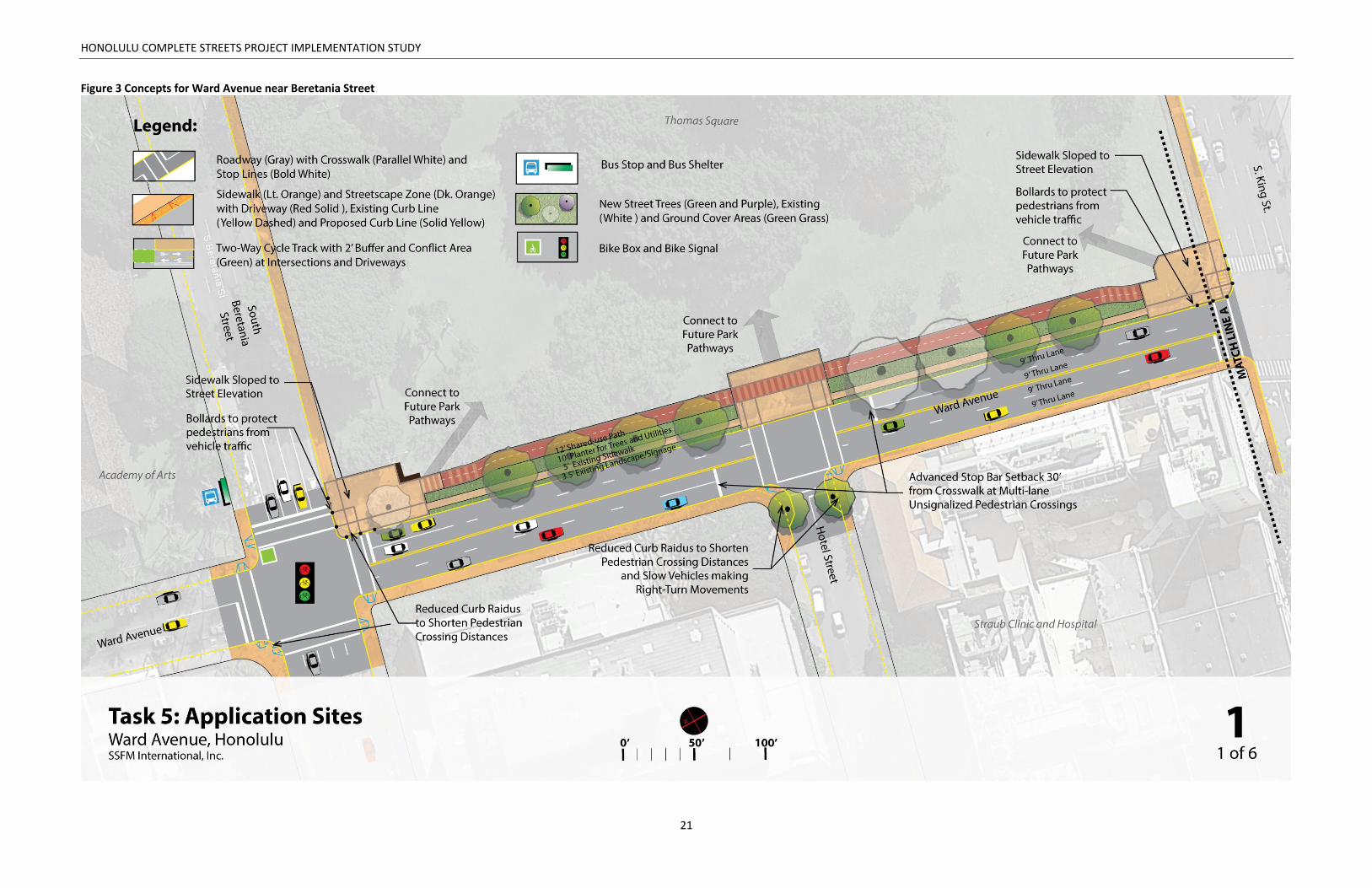
Figure 3 Concepts for Ward Avenue near Beretania Street ....................................................................... 21
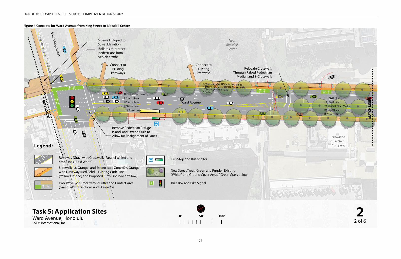
Figure 4 Concepts for Ward Avenue from King Street to Blaisdell Center ................................................. 23
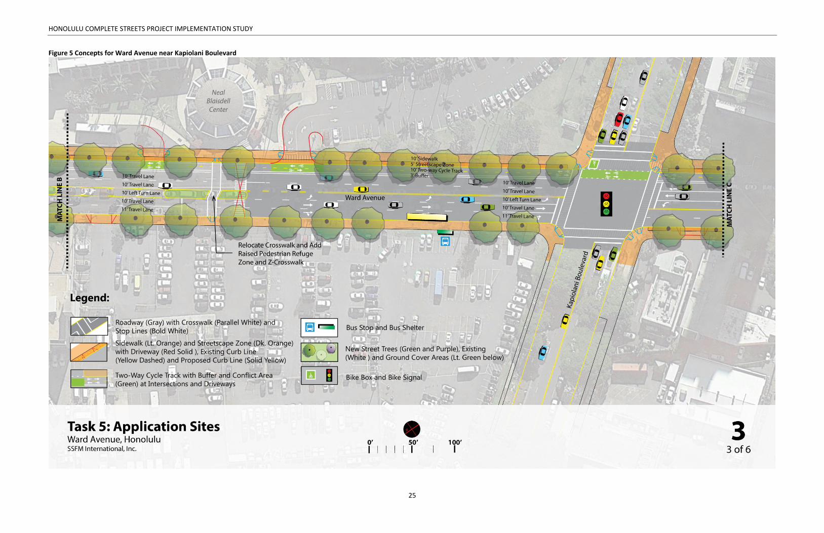
Figure 5 Concepts for Ward Avenue near Kapiolani Boulevard ................................................................. 25
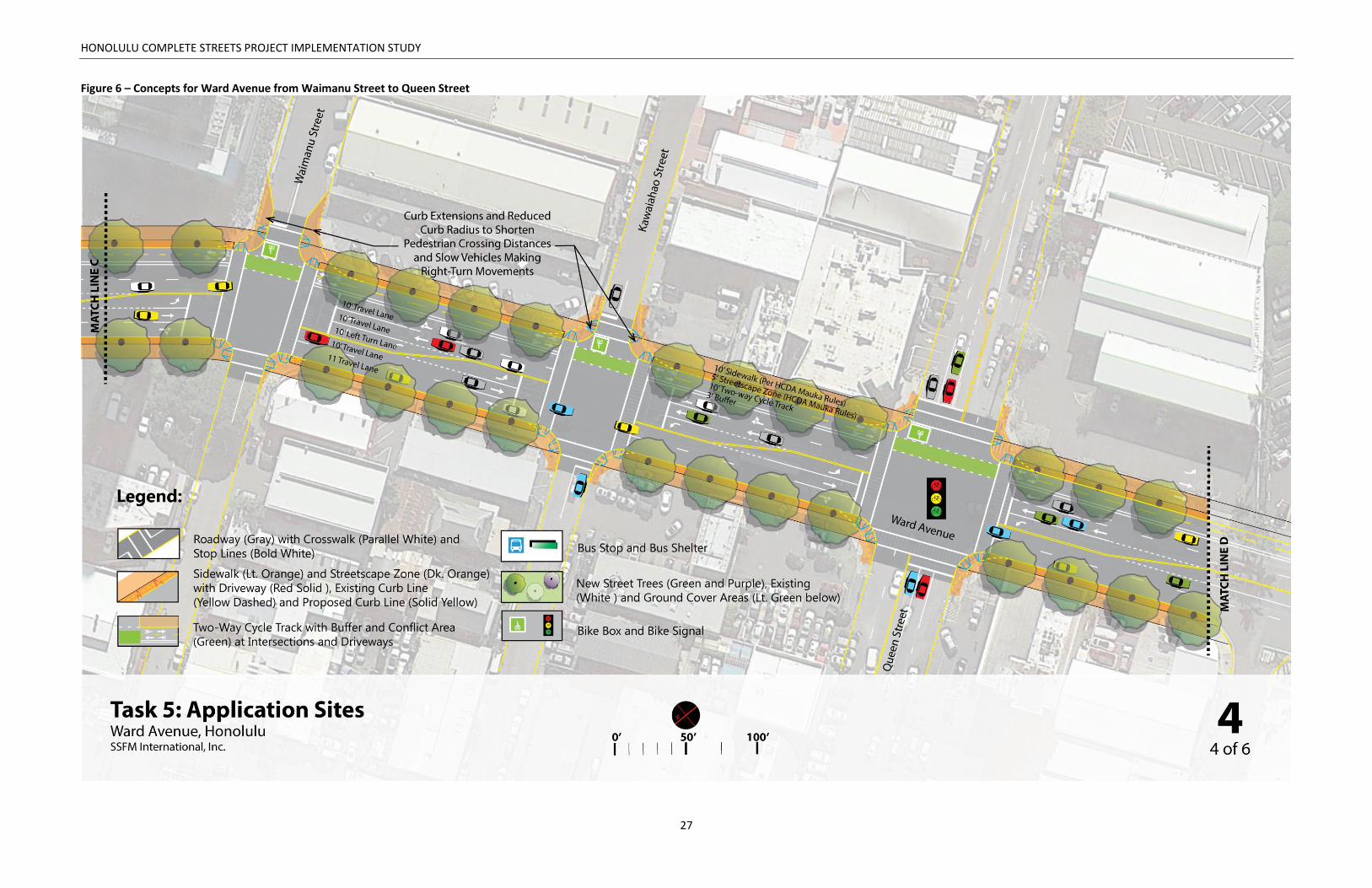
Figure 6 – Concepts for Ward Avenue from Waimanu Street to Queen Street ......................................... 27
Figure 7 – Concepts for Ward Avenue near Halakauwila Street................................................................. 29
Figure 8 – Concepts for Ward Avenue near Ala Moana Boulevard ............................................................ 31
List of Tables Table 1 Existing Usage Patterns along Ward Avenue ................................................................................... 6
Table 2 Proposed Design Changes to Ward Avenue ................................................................................... 18
HONOLULU COMPLETE STREETS PROJECT IMPLEMENTATION STUDY
1
Part One: Introduction, Study Area, & Need for
Project
WHAT ARE COMPLETE STREETS?
Complete Streets is a transportation policy and design approach. It aims to create a comprehensive,
integrated network of streets that are safe and convenient for all people whether traveling by foot,
bicycle, transit, or automobile, and regardless of age or ability. Complete Streets moves away from streets
designed with a singular focus on automobiles towards a design approach that is context-sensitive, multi-
modal, and integrated with the community’s vision and sense of place. The end result is a road network
that provides safe travel, promotes public health, and creates stronger communities.
Implementing Complete Streets requires integrating transportation with community planning. Changes
are brought about by transforming the built environment. Engineers, planners, architects, landscape
architects, and urban design professionals work along with health providers, business leaders, elected
officials, community organizations, and residents to promote Complete Streets implementation. Actively
engaged community members in Complete Streets are important participants and stakeholders. They help
to ensure that efforts are relevant to the community’s use, values, and priorities for the neighborhood.
The State of Hawaii adopted Complete Streets in 2009 and required each County to follow suit. In May
2012, the Honolulu City Council adopted a “Complete Streets” policy and passed Ordinance 12-15. The
City and County of Honolulu is now taking aggressive steps to implement Complete Streets by updating
policies, applying guidelines during maintenance and paving projects, and designing projects in specific
locations. The City and County of Honolulu selected fourteen sites across the island of Oahu for in-depth
study to illustrate how Complete Streets can be applied in a specific location. This report describes one of
the selected sites and presents recommendations to implement Complete Streets at that location.
STUDY AREA
The subject location of this assessment is Ward Avenue from Halekauwila Street to Beretania Street
(Figure 1). It is located in the Primary Urban Center Planning Area, Sub-Area of Kakaako, in City Council
District V. Ward Avenue is a major mauka-makai (mountainside-oceanside) corridor running from H-1 to
Ala Moana Boulevard. Uses along Ward Avenue range from medical facilities to parks, major shopping
centers, and event facilities.

HONOLULU COMPLETE STREETS PROJECT IMPLEMENTATION STUDY
2
Figure 1 Study Area

HONOLULU COMPLETE STREETS PROJECT IMPLEMENTATION STUDY
3
NEED FOR PROJECT
This location was selected for Complete Streets
treatment because of its high traffic volumes and
numerous major destinations. At the makai end,
Ward Avenue is home to a large shopping center
between Auahi and Queen Streets. Just mauka of
Kapiolani Boulevard sits the Neal Blaisdell
community center. Closer to Beretania Street on
the west side of Ward Avenue is the Straub Hospital
complex.
Ward Avenue already attracts many types of users
at all times of day to these residential, employment,
retail, and service destinations. A large new
residential development at the intersection with
Kapiolani Boulevard, plus plans for future rail
service in the area make it clear that vibrancy and
intensity of use will continue to increase along this
already busy corridor.
This presents an opportunity to make Ward Avenue
a multimodal hub. Improvements can make the
street safer and more attractive for current and
future users. Given the high traffic volumes on
Ward Avenue, multimodal access will ensure that
people can live on and visit the destinations along the corridor without adding a large number of vehicle
trips.
Current challenges to walkability include sidewalks that are not well buffered from auto traffic, and that
lack shade. Most intersections feature turning lanes, making long crossings for pedestrians. They also
feature wide turning radii, increasing the speed at which vehicles can make turns. During a walking audit
conducted in 2014, many older adults were observed crossing the street toward the mauka end of Ward
Avenue near Straub Hospital. These vulnerable users in particular would benefit from safer and shorter
crossings.
No bicycling facilities exist along Ward Avenue. The Oahu Bicycle Plan shows a future bicycle route along
it. However, given the high traffic volumes, a signed and shared route alone will not appeal to the majority
of bicycle riders.
By adding trees, bicycle facilities, and improved walking facilities, Ward Avenue has the potential to
continue to develop without increased congestion.
The north end of Ward Avenue serves the Hospital and experiences a high volume of pedestrian traffic.
The Blaisdell Center between Kapiolani and King Streets is a major pedestrian generator at times.
HONOLULU COMPLETE STREETS PROJECT IMPLEMENTATION STUDY
4
EXISTING LAND USE, TRANSPORTATION FACILITES, AND USAGE PATTERNS
Land Use, Transportation Facilities and Traffic Accidents
Figure 2 depicts existing land use, transportation facilities, and traffic accident data within the study area.
The makai end of Ward Avenue is within the Kakaako Community Development District. The
redevelopment of this area is controlled by the Hawaii Community Development Authority (HCDA), which
has established certain streetscape standards. The area makai of Waimanu Street sits within the central
Kakaako neighborhood. This is the site of a large shopping center, a portion of which is slated to become
a future rail station. The Kapiolani and Thomas Square neighborhoods at Kapiolani Boulevard and near
King Street, respectively, are also sub-areas of the Kakaako Community Development District. Mauka of
King Street, Ward Avenue contains mixed-use businesses and a historic park, Thomas Square.
Major destinations include the shopping center near Queen Street, the Blaisdell Community Center,
Thomas Square Park, and Straub Hospital. Walk and transit scores rank above average (high 80s to low
90s and mid to high 70s respectively) in the areas surrounding the project site, which indicates a favorable
pedestrian and transit environment1. Continuous sidewalks exist on both sides of the street, but only have
buffers toward the mauka end. Crosswalks are generally well-spaced, from 300-475 feet, but three are
uncontrolled (two at the Blaisdell Center and one at Ilaniwai Street). Bike scores range from the low to
upper 60s, likely due to a lack of bicycle facilities.
For most of its extent, Ward Avenue consists of two lanes per direction plus a turn lane. On-street off-
peak parking is present on the Ewa side of the street between Kapiolani Boulevard and King Street.
From 2011-2014, 100 accidents occurred along or adjacent to Ward Avenue, with the highest number at
Beretania Street and Ward Avenue. Of the 100 accidents, eight involved bicyclists and 20 involved
pedestrians.
Usage Patterns
Table 1 describes existing usage patterns by pedestrians, bicyclists, vehicles, and transit users in the study
area. Data on pedestrian use is not available, however a walking audit conducted in the summer of 2014
indicated anecdotally that there is a high level of pedestrian use, especially mauka of Kapiolani Boulevard.
Few cyclists were observed.
Thirteen bus lines serve the corridor, and ridership is high, with more than 3,000 daily users.
Traffic volumes are high at around 30,000 per day.
1 Walk, transit, and bike scores are an index of walkability, transit accessibility, and bikeability (respectively) based on proximity to amenities and destinations (e.g. grocery stores, schools, parks, restaurants, and retail). Walk scores were developed by “Walk Score,” a private company (www.walkscore.com).

HONOLULU COMPLETE STREETS PROJECT IMPLEMENTATION STUDY
5
Figure 2 Existing Land Use, Transportation Facilities, and Crashes in the Study Area

HONOLULU COMPLETE STREETS PROJECT IMPLEMENTATION STUDY
6
Table 1 Existing Usage Patterns along Ward AvenuePedestrian use High. The Blaisdell Center and Straub Hospital are major trip generators.
Bicycle use Low
Transit use (Average daily
boardings + alightings)
(Source: Global Stop
Summary by Trip, TheBus,
2012)
Stops
Ward + Halekauwila: 251
Ward + Kapiolani : 1,089
Ward + King: 1,009
Ward + Beretania: 970
Boardings and Alightings by Route
Route 1 - 739 (ADR)
Route 13 - 238 (ADR)
Route 15 - 138 (ADR)
Route 1L - 160 (ADR)
Route 2 - 910 (ADR)
Route 2L - 80 (ADR)
Route 3 - 353 (ADR)
Route 40 - 100 (ADR)
Route 52 - 93 (ADR)
Route 53 - 79 (ADR)
Route 6 - 251 (ADR)
Route 62 - 13 (ADR)
Route 9 - 163 (ADR)
Daily Vehicular Volumes
(Source: Historical Traffic
Station Maps, HDOT,
2013-2009)
Ward Avenue: Hotel Street to Beretania Street (2011) – 31,175
Beretania Street: Hale Makai Street to Alapai Street (2011) – 30,014
Beretania Street to Kinau Street (2011) – 34,545
Ward Avenue: Kapiolani Boulevard to King Street (2011) – 29,573
Kapiolani Boulevard: Dreier Street to Chapin Street (2013) – 34,532
Queen Street: Cummins Street to Ward Avenue (2011) – 7,791
Ward Avenue: Auahi Street to Halekauwila Street (2011) – 23,483
Use by trucks or large
vehicles
N/A
Peak periods
(Source: Historical Traffic
Station Maps, HDOT,
2013)
Ward Avenue: Hotel Street to Beretania Street (2011) - 11:00 AM to 12:00 PM, 4:30
PM to 5:30 PM
Ward Avenue: Kapiolani Boulevard to King Street (2011) - 7:30 AM to 8:30 AM, 4:15
PM to 5:15 PM
Beretania Street: Hale Makai Street to Alapai Street (2011) - 7:15 AM to 8:15 AM, 4:15
PM to 5:15 PM
Queen Street: Cummins Street to Ward Avenue (2011) - 11:00 AM to 12:00 PM, 4:45
PM to 5:45 PM
Ward Avenue: Auahi Street to Halekauwila Street (2011) - 11:00 AM to 12:00 PM, 1:00
PM to 2:00 PM
Beretania Street to Kinau Street (2011) - 11:00 AM to 12:00 PM, 3:30 PM to 4:30 PM
Kapiolani Boulevard: Dreier Street to Chapin Street (2013) - 7:15 AM to 8:15 AM, 4:30
PM to 5:30 PM

HONOLULU COMPLETE STREETS PROJECT IMPLEMENTATION STUDY
7
Accident History
Sources: State of Hawaii
Motor Vehicle Accident
Reports, Honolulu Police
Department, Records
Division, 2011-2014
Between 2011 and 2014, 100 crashes occurred along or adjacent to Ward. More
than half the crashes involved cars, trucks, or motorcycles only. Eight bicyclists and
20 pedestrians were injured. The most dangerous location was at Beretania and
Ward, where 34 crashes occurred. Ward Avenue and King Street and Ward Avenue
and Kapiolani Boulevard are the next most dangerous intersections.

HONOLULU COMPLETE STREETS PROJECT IMPLEMENTATION STUDY
8
This page has been left blank intentionally.

HONOLULU COMPLETE STREETS PROJECT IMPLEMENTATION STUDY
9
Part Two: Field Work and Key Findings
STAKEHOLDER INPUT
The findings of this report are informed by input received from community stakeholders that participated
in a walking audit along Ward Avenue. SSFM International, Inc., and a team of national consultants,
including Dan Burden, national walkability expert, led the walking audit on July 17, 2014. The following
stakeholders participated in the walking audit:
City and County of Honolulu Department of Transportation Services (DTS): Mark Garrity, Kelly
Cruz, Erron Redoble, Randall Kurashigo, Craig Chung, Chris Sayers, Yamato Milner, Mark Kikuchi,
Rika Uechi, Diane Toramoto, Nial Miyata
Jonathan Tungpalan of Representative Saiki’s office, Carol Fukunaga and Chris Delaney from the
City Council office;
Daniel Alexander of the Hawaii Bicycling League (HBL):;
Roy Bumgarner and Pam Wood of the Imperial Plaza;
Isaiah Sato of the Howard Hughes Corporation;
Serge Krivaby of Oliver McMillan;
Consultant Team: Mike Packard, Alan Fujimori, and Michael Motoki of SSFM, Dan Burden and
Samantha Thomas of Blue Zones, and Stephanie Wright of Nelson Nygaard.
The walk audit group discussed conditions that affect active living, social connectivity, and access to daily
needs. The participants noted that the street was unpleasant to walk along due to large intersections,
high traffic volumes, and lack of streetscaping and shade. Land uses such as the shopping center at Queen
Street with large parking lots fronting the street contribute to the auto-oriented nature of the area.
Participants expressed fears about using the unprotected crossings located along the corridor due to the
A walking audit brought together 23 leaders from the City and County of Honolulu, State agencies, and community stakeholders including a local employer and Hawaii Bicycling League.

HONOLULU COMPLETE STREETS PROJECT IMPLEMENTATION STUDY
10
high traffic volumes and the fact that there are often five lanes (two per direction plus a turn lane) to
cross. People were extremely enthusiastic about the idea of adding protected bike lanes along Ward
Avenue.
Participants shared visions, barriers, and opportunities for Complete Streets and safer routes to school along Ward Avenue. Photo descriptions: Top row - Members of DTS and participants experience Ward Avenue; Middle row - Members of the DTS and public explain their ideas and concerns; Bottom row – Walk audit participants learn about the corridor’s land use and transportation characteristics before the tour.
HONOLULU COMPLETE STREETS PROJECT IMPLEMENTATION STUDY
11
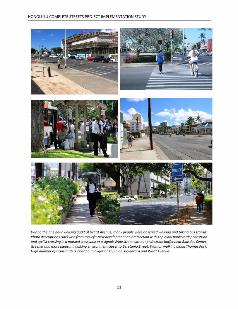
During the one hour walking audit of Ward Avenue, many people were observed walking and taking bus transit. Photo descriptions clockwise from top left: New development at intersection with Kapiolani Boulevard; pedestrian and cyclist crossing in a marked crosswalk at a signal; Wide street without pedestrian buffer near Blaisdell Center; Greener and more pleasant walking environment closer to Beretania Street; Woman walking along Thomas Park; High number of transit riders board and alight at Kapiolani Boulevard and Ward Avenue.
HONOLULU COMPLETE STREETS PROJECT IMPLEMENTATION STUDY
12
FINDINGS
This section summarizes key findings based on observations made by the consultant team with input from
Department of Transportation Services staff and community stakeholders who participated in the walking
audit. These inform the recommendations summarized in the next section.
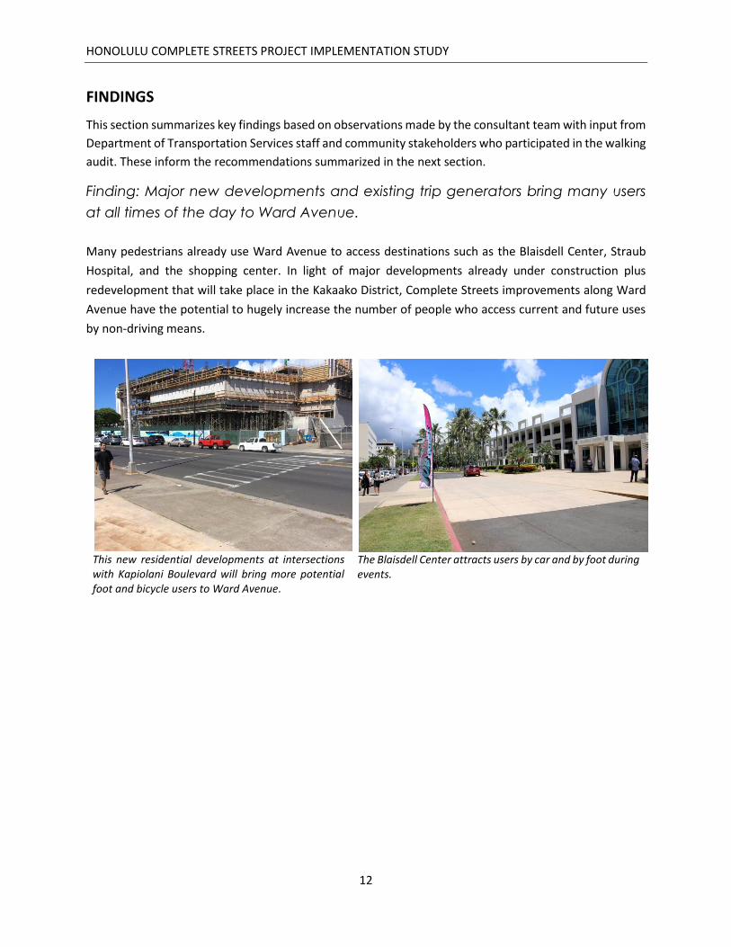
Finding: Major new developments and existing trip generators bring many users
at all times of the day to Ward Avenue.
Many pedestrians already use Ward Avenue to access destinations such as the Blaisdell Center, Straub
Hospital, and the shopping center. In light of major developments already under construction plus
redevelopment that will take place in the Kakaako District, Complete Streets improvements along Ward
Avenue have the potential to hugely increase the number of people who access current and future uses
by non-driving means.
This new residential developments at intersections with Kapiolani Boulevard will bring more potential foot and bicycle users to Ward Avenue.
The Blaisdell Center attracts users by car and by foot during events.
HONOLULU COMPLETE STREETS PROJECT IMPLEMENTATION STUDY
13
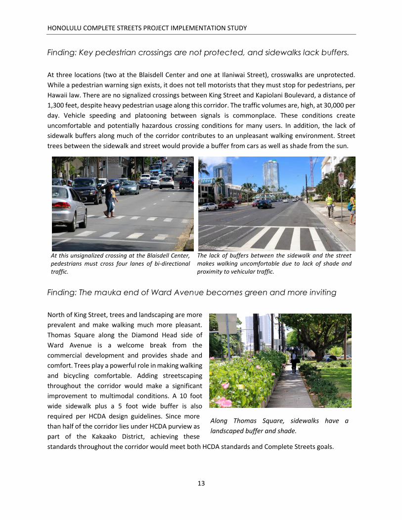
Finding: Key pedestrian crossings are not protected, and sidewalks lack buffers.
At three locations (two at the Blaisdell Center and one at Ilaniwai Street), crosswalks are unprotected.
While a pedestrian warning sign exists, it does not tell motorists that they must stop for pedestrians, per
Hawaii law. There are no signalized crossings between King Street and Kapiolani Boulevard, a distance of
1,300 feet, despite heavy pedestrian usage along this corridor. The traffic volumes are, high, at 30,000 per
day. Vehicle speeding and platooning between signals is commonplace. These conditions create
uncomfortable and potentially hazardous crossing conditions for many users. In addition, the lack of
sidewalk buffers along much of the corridor contributes to an unpleasant walking environment. Street
trees between the sidewalk and street would provide a buffer from cars as well as shade from the sun.
At this unsignalized crossing at the Blaisdell Center, pedestrians must cross four lanes of bi-directional traffic.
The lack of buffers between the sidewalk and the street makes walking uncomfortable due to lack of shade and proximity to vehicular traffic.
Finding: The mauka end of Ward Avenue becomes green and more inviting
North of King Street, trees and landscaping are more
prevalent and make walking much more pleasant.
Thomas Square along the Diamond Head side of
Ward Avenue is a welcome break from the
commercial development and provides shade and
comfort. Trees play a powerful role in making walking
and bicycling comfortable. Adding streetscaping
throughout the corridor would make a significant
improvement to multimodal conditions. A 10 foot
wide sidewalk plus a 5 foot wide buffer is also
required per HCDA design guidelines. Since more
than half of the corridor lies under HCDA purview as
part of the Kakaako District, achieving these
standards throughout the corridor would meet both HCDA standards and Complete Streets goals.
Along Thomas Square, sidewalks have a
landscaped buffer and shade.

HONOLULU COMPLETE STREETS PROJECT IMPLEMENTATION STUDY
14
Finding: Intersection design and wide turning radii make crossings challenging
Intersections are the main conflict points at which all modes interact. The intersections with Queen Street,
King Street, and Kapiolani Boulevard in particular are very wide, with turn lanes and wide turning radii.
The larger the turning radius, the longer the crossing distance for pedestrians.
Corner radii along Ward Avenue is very large. Smaller radii would lower turning speeds and shorten pedestrian crossings.
The intersection of Ward Avenue and Queen Street is wide and creates a very long pedestrian crossing. The intersection of King Street and Kapiolani Boulevard is also very large. Intersections should be kept as compact as possible to increase visibility and reduce the amount of space and time vulnerable users are exposed to auto traffic.
Finding: Many older adults use the area
near the Hospital
Closer to Beretania Street, the Straub Hospital is a
major pedestrian generator. During a walk audit,
many older adults were observed crossing Ward
Avenue and accessing the hospital complex. Similar to
the emphasis on safety placed at schools, older adults
are a vulnerable population and benefit from
enhanced safety measures such as minimizing
crossing distance, lengthening walk signal timing, and
making getting on and off the sidewalk easy through
ADA-compliant curb ramps.
Older adults crossing the street by the hospital
HONOLULU COMPLETE STREETS PROJECT IMPLEMENTATION STUDY
15
Part Three: Recommended Application of
Complete Streets Concepts
This section describes the recommended application of Complete Streets concepts for Ward Avenue. It
includes a written description of recommendations accompanied by illustrative drawings. The Complete
Streets principles incorporated are:
Encourage multiple modes of transportation, particularly walking and biking
Promote safety for all modes of transportation
Promote safer street crossings, and
Strengthen connections to community destinations
COMPLETE STREETS RECOMMENDATIONS
Conceptual Illustrations of Recommendations
The recommendations for Ward Avenue are described below and shown on Figures 3 through 8. Table 2
is a summary list of all recommendations, the before and after effect. Drawings of the proposed changes
are presented for five segments of Ward Avenue:
Near Beretania Street (Figure 3)
From King Street to Blaisdell Center (Figure 4)
Near Kapiolani Boulevard (Figure 5)
From Waimanu Street to Queen Street (Figure 6)
Near Halakauwila Street (Figure 7)
Near Ala Moana Boulevard (Figure 8)
These recommended changes are described in the following section and summarized in Table 2.
HONOLULU COMPLETE STREETS PROJECT IMPLEMENTATION STUDY
16
Description of Recommendations
The recommendations in Figures 3 through 8 are summarized below.
A) Increase pedestrian safety along the corridor.
Expand sidewalks to be consistently 10 feet wide on both sides of the corridor.
Work with City’s Thomas Square redevelopment efforts to provide shared-use path within park.
At all unsignalized pedestrian crossings, install advanced stop bars 30 feet back from each
crosswalk to enhance visibility and safety for pedestrians.
Reduce curb radii at intersections and use curb extensions.
Enhance pedestrian entrances to Thomas Square using gateway treatments.
Install one ADA compliant curb ramp per crosswalk rather than a single ramp at the apex of the
curve. This maximizes access by placing ramps in line with the sidewalk and crosswalk, and
reduces the distance required to cross the street.
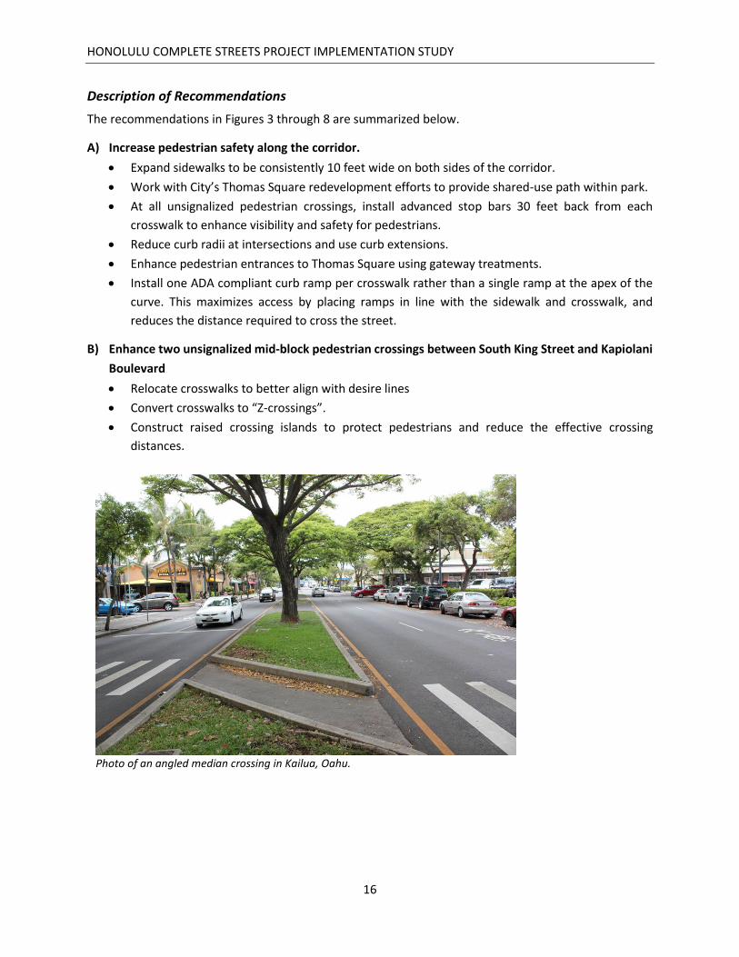
B) Enhance two unsignalized mid-block pedestrian crossings between South King Street and Kapiolani
Boulevard
Relocate crosswalks to better align with desire lines
Convert crosswalks to “Z-crossings”.
Construct raised crossing islands to protect pedestrians and reduce the effective crossing
distances.
Photo of an angled median crossing in Kailua, Oahu.

HONOLULU COMPLETE STREETS PROJECT IMPLEMENTATION STUDY
17
C) Increase safety for bicyclists along the corridor.
Install a two-way cycle track (protected bike lanes) between South King Street and Ala Moana
Boulevard.
o Create a 10 foot two-way cycle track on the Diamond Head side of Ward Avenue.
o Protect the cycle track with a 2 foot wide buffer.
o Paint conflict areas green when the cycle track crosses driveways and intersections.
o Install “turning vehicles stop for pedestrians and cyclists” signs to alert motorists turning right
across the cycle track to yield.
Between South Beretania Street and South King Street, transition new cycle track to a 12-foot
wide shared-use path and landscape buffer within Thomas Square.
o Provide a ramp for bicyclists to transition to sidewalk level.
o Install 10 foot wide landscaping buffer between the existing sidewalk and shared-use path.
o Retain existing 5 foot wide sidewalk and 3.5 foot buffer on the Diamond Head side.
o Install signage and pavement markings to delineate proper paths of travel for bicyclists and
pedestrians.
Install bicycle signals at all signalized intersections to improve identified safety or operational
problems for people on bicycles.
o Paint bike boxes so a two-stage left turn can be made by bicyclists.
o Add a Leading Bicycle Interval (LBI) phase to bicycle signals, giving cyclists a head start into
the intersection ahead of turning drivers.
D) Enhance streetscaping and comfort for all modes of transportation.
Install a 10 foot wide landscaping buffer in the areas abutting Thomas Square (see
Recommendation C).
Plant trees on both sides of Ward Avenue throughout the corridor.
HONOLULU COMPLETE STREETS PROJECT IMPLEMENTATION STUDY
18
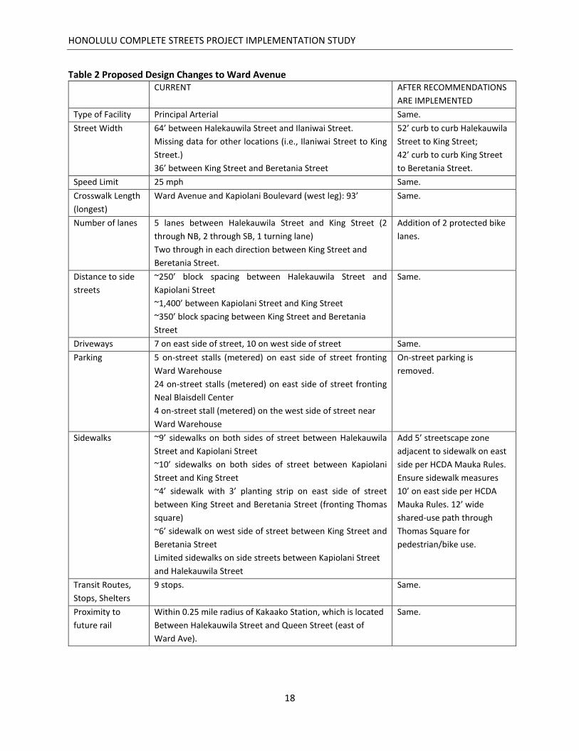
Table 2 Proposed Design Changes to Ward Avenue CURRENT AFTER RECOMMENDATIONS
ARE IMPLEMENTED
Type of Facility Principal Arterial Same.
Street Width 64’ between Halekauwila Street and Ilaniwai Street.
Missing data for other locations (i.e., Ilaniwai Street to King
Street.)
36’ between King Street and Beretania Street
52’ curb to curb Halekauwila
Street to King Street;
42’ curb to curb King Street
to Beretania Street.
Speed Limit 25 mph Same.
Crosswalk Length
(longest)
Ward Avenue and Kapiolani Boulevard (west leg): 93’ Same.
Number of lanes 5 lanes between Halekauwila Street and King Street (2
through NB, 2 through SB, 1 turning lane)
Two through in each direction between King Street and
Beretania Street.
Addition of 2 protected bike
lanes.
Distance to side
streets
~250’ block spacing between Halekauwila Street and
Kapiolani Street
~1,400’ between Kapiolani Street and King Street
~350’ block spacing between King Street and Beretania
Street
Same.
Driveways 7 on east side of street, 10 on west side of street Same.
Parking 5 on-street stalls (metered) on east side of street fronting
Ward Warehouse
24 on-street stalls (metered) on east side of street fronting
Neal Blaisdell Center
4 on-street stall (metered) on the west side of street near
Ward Warehouse
On-street parking is
removed.
Sidewalks ~9’ sidewalks on both sides of street between Halekauwila
Street and Kapiolani Street
~10’ sidewalks on both sides of street between Kapiolani
Street and King Street
~4’ sidewalk with 3’ planting strip on east side of street
between King Street and Beretania Street (fronting Thomas
square)
~6’ sidewalk on west side of street between King Street and
Beretania Street
Limited sidewalks on side streets between Kapiolani Street
and Halekauwila Street
Add 5’ streetscape zone
adjacent to sidewalk on east
side per HCDA Mauka Rules.
Ensure sidewalk measures
10’ on east side per HCDA
Mauka Rules. 12’ wide
shared-use path through
Thomas Square for
pedestrian/bike use.
Transit Routes,
Stops, Shelters
9 stops. Same.
Proximity to
future rail
Within 0.25 mile radius of Kakaako Station, which is located
Between Halekauwila Street and Queen Street (east of
Ward Ave).
Same.

HONOLULU COMPLETE STREETS PROJECT IMPLEMENTATION STUDY
19
Bicycle features
Proposed bike route on Ward Ave. Two way cycle track
(protected bike lanes) on
Diamond Head side of Ward
Avenue with bike boxes for
left turns and bike signals.
12’ wide shared-use path
through Thomas Square for
pedestrian/bike use.
Nearby Schools McKinley High School. Same.
Nearby
Institutions
Honolulu Museum of Art, Neal S. Blasidell Center, Straub
Clinic and Hospital
Same.

HONOLULU COMPLETE STREETS PROJECT IMPLEMENTATION STUDY
20
This page has been left blank intentionally.
HONOLULU COMPLETE STREETS PROJECT IMPLEMENTATION STUDY
21
Figure 3 Concepts for Ward Avenue near Beretania Street

HONOLULU COMPLETE STREETS PROJECT IMPLEMENTATION STUDY
22
This page has been left blank intentionally.
HONOLULU COMPLETE STREETS PROJECT IMPLEMENTATION STUDY
23
Figure 4 Concepts for Ward Avenue from King Street to Blaisdell Center

HONOLULU COMPLETE STREETS PROJECT IMPLEMENTATION STUDY
24
This page has been left blank intentionally.
HONOLULU COMPLETE STREETS PROJECT IMPLEMENTATION STUDY
25
Figure 5 Concepts for Ward Avenue near Kapiolani Boulevard

HONOLULU COMPLETE STREETS PROJECT IMPLEMENTATION STUDY
26
This page has been left blank intentionally.
HONOLULU COMPLETE STREETS PROJECT IMPLEMENTATION STUDY
27
Figure 6 – Concepts for Ward Avenue from Waimanu Street to Queen Street

HONOLULU COMPLETE STREETS PROJECT IMPLEMENTATION STUDY
28
This page has been left blank intentionally.
HONOLULU COMPLETE STREETS PROJECT IMPLEMENTATION STUDY
29
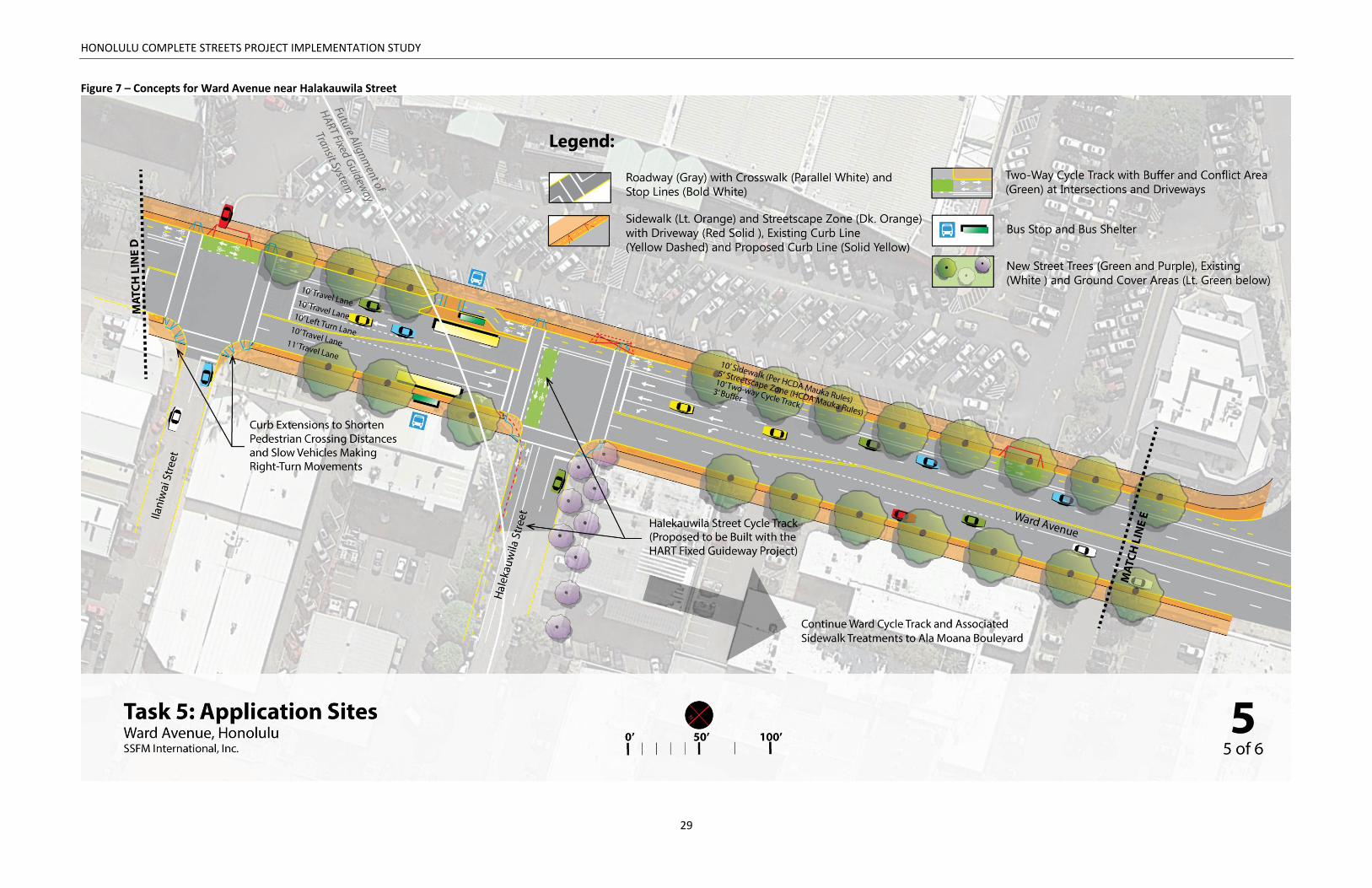
Figure 7 – Concepts for Ward Avenue near Halakauwila Street

HONOLULU COMPLETE STREETS PROJECT IMPLEMENTATION STUDY
30
This page has been left blank intentionally.

HONOLULU COMPLETE STREETS PROJECT IMPLEMENTATION STUDY
31
Figure 8 – Concepts for Ward Avenue near Ala Moana Boulevard

HONOLULU COMPLETE STREETS PROJECT IMPLEMENTATION STUDY
32
This page has been left blank intentionally.

HONOLULU COMPLETE STREETS PROJECT IMPLEMENTATION STUDY
33
Part Four: Implementation This section looks at the recommendations and sorts them according to how soon they can be
implemented. Near-term actions are those that may be implemented immediately through incorporation
into existing City paving, marking, or signage projects or maintenance funding. Mid-term actions are those
that may require or warrant a longer planning horizon (1 to 5 years) due to logistical, financial, or other
considerations. Longer-term actions are those that may require or warrant an even longer planning
horizon (5 years and beyond).
Near-Term Actions (0-1 year):
A) Increase safety for walking along the corridor.
At all unsignalized pedestrian crossings, install advanced stop bars 30 feet back from each
crosswalk to enhance visibility and safety for pedestrians.
Reduce curb radii at intersection using striping and bollards.
B) Enhance two unsignalized mid-block pedestrian crossings that are between South King Street and
Kapiolani Boulevard
Restripe mid-block crosswalks, and add advanced stop lines that are setback 30 feet.
Stripe pedestrian refuge islands.
Photo of a mid-block crossing with advanced stop line on King Street, Honolulu.

HONOLULU COMPLETE STREETS PROJECT IMPLEMENTATION STUDY
34
C) Increase safety for bicyclists along the corridor.
Between South King Street and Ala Moana Boulevard, restripe the roadway and include a 10 foot
wide cycle track.
o Restripe and narrow travel lanes as shown in Figures 3-7.
o Stripe a 10 foot wide two-way cycle track on the Diamond Head side of Ward Avenue
o Install a two-foot buffer adjacent to the cycle track using striping, and traffic delineator posts.
o Paint conflict areas green when the cycle track crosses driveways and intersections.
o Install “turning vehicles stop for pedestrians and cyclists” signs to alert motorists turning right
across the cycle track to yield.
Between South Beretania Street and South King Street temporarily transition to a shared-use path
using the existing sidewalk.
o Install signage and pavement markings indicating the proper path of travel for each mode.
Paint bike boxes when bicyclists can make left turns so a two-stage turn can be made.
D) Enhance streetscaping and comfort for all modes of transportation.
None
Photo of a bike box connected to a two-way cycle track in Seattle, WA

HONOLULU COMPLETE STREETS PROJECT IMPLEMENTATION STUDY
35
Mid-Term Actions (1 to 5 years):
A) Increase safety for walking along the corridor.
Use asphalt concrete A/C berms (or similar) to reduce curb radii at intersection.
B) Enhance two unsignalized mid-block pedestrian crossings that are between South King Street and
Kapiolani Boulevard
Use A/C berms (or similar) to define pedestrian refuge islands.
Restripe as “Z-crossing” and install new curb ramps.
C) Increase safety for bicyclists along the corridor.
Install bicycle signals and protected – only left-turn arrows for makai-bound vehicles, at all
signalized intersections.
o Adjust traffic signal phasing to include a Leading Bicycle Interval phase to bicycle signals.
Between South Beretania and South King Street, transition new cycle track to a 12-foot wide
shared-use path within Thomas Square.
o Provide a ramp for bicyclists to transition to sidewalk level.
o As a part of the redevelopment of Thomas Square, install a 10 foot wide landscaping buffer
between the sidewalk and shared-use path.
o Install signage and pavement markings to delineate proper paths of travel for bicyclists and
pedestrians.
D) Enhance streetscaping and comfort for all modes of transportation.
Install planters on both sides of Ward Avenue throughout the corridor.
Longer-Term Actions (5 years and Beyond):
A) Increase safety for walking along the corridor.
Widen the sidewalk (i.e., the streetscape zone) to 10 feet wide as per HCDA Mauka Rules.
Reduce curb radii at intersection using concrete curb extensions that are flush to the existing
sidewalk.
Install one ADA compliant curb ramp per crosswalk rather than a single ramp at the apex of the
curve.
B) Enhance two unsignalized mid-block pedestrian crossings that are between South King Street and
Kapiolani Boulevard
Construct permanent raised crossing islands and center medians.
C) Increase safety for bicyclists along the corridor.
D) Enhance streetscaping and comfort for all modes of transportation.
Install pedestrian scale lighting in the landscaping area abutting Thomas Square.
Install landscaping in raised center medians (see Recommendation B).
Install a 5 foot wide landscaping buffer between the new sidewalk and new raised cycle track in
the areas abutting Thomas Square to separate bicycle and pedestrian modes.

HONOLULU COMPLETE STREETS PROJECT IMPLEMENTATION STUDY
36
This page has been left blank intentionally.

HONOLULU COMPLETE STREETS PROJECT IMPLEMENTATION STUDY
37
Part Five: Cost Sheet
ITEM UNIT QUANTITY UNIT COST TOTAL COST
Demolish existing sidewalk Sq. Ft. 16710 5.00$ 83,550.00$
Demolish existing Pavement Sq. Ft. 6270 8.00$ 50,160.00$
Erosion Control L.S. 1 10,000.00$ 10,000.00$
Mill and Overlay existing AC pavement Sq. Ft. 189950 6.00$ 1,139,700.00$
Curb Gutter and Sidewalk Sq. Ft. 32614 20.00$ 652,280.00$
Streetscape Sq. Ft. 15935 20.00$ 318,700.00$
Raised Median Sq. Ft. 3070 20.00$ 61,400.00$
Drainage works each 12 14,000.00$ 168,000.00$
4" Stripe (white/Yellow) Lin. Ft. 23640 6.00$ 141,840.00$
12"stripe (white) Lin. Ft. 4850 9.00$ 43,650.00$
10' Bike lane (Green) Sq. Ft. 6250 9.00$ 56,250.00$
Striping Symbols each 54 300.00$ 16,200.00$
Delineators at 10' spacing each 223 100.00$ 22,300.00$
Traffic Signal Modification each 5 350,000.00$ 1,750,000.00$
Trees each 90 1,000.00$ 90,000.00$
Traffic Control L.S. 1 5% 230,201.50$
Mobilization L.S. 1 10% 460,403.00$
Contingency - 25% 25% 1,151,007.50$
Design Cost 6% 386,738.52$
TOTAL CONSTRUCTION 6,445,642.00$
TOTAL COST 6,832,380.52$
Design
Removals/Demo
Site improvements
Roadway
Intersection
Landscaping
Misc.