historic context of the interstate highway system in … historic context of the interstate highway...
TRANSCRIPT
Georgia Department of TransportationOffice of Environment/Location
Project Task Order No. 94Contract EDS-0001-00(755)
Historic Context of theInterstate Highway System in Georgia
Prepared by:Lichtenstein Consulting Engineers
1 Oxford Valley, Suite 818Langhorne, PA 19047
(215) 752-2206
March 2007
Table of Contents
Introduction . . . . . . . . . . . . . . . . . . . . . . . . . . . . . . . . . . . . . . . . . . . . . . . . . . . . . . . . . . . . . . . . 1
The National Interstate Context: Federalism and Standards . . . . . . . . . . . . . . . . . . . . . . . . . . 1
Getting Started . . . . . . . . . . . . . . . . . . . . . . . . . . . . . . . . . . . . . . . . . . . . . . . . . . . . . . . . . . . . . 4
The Origin of Interstate Highways in Georgia: The Lochner Plan and Atlanta Expressway . . . 4
Initial Impact of the Atlanta Expressway . . . . . . . . . . . . . . . . . . . . . . . . . . . . . . . . . . . . . . . . . . 7
Establishing the National System of Interstate and Defense Highways in 1956 . . . . . . . . . . . 8
Interstate Highway Design Standards . . . . . . . . . . . . . . . . . . . . . . . . . . . . . . . . . . . . . . . . . . 10
Georgia Interstate Construction 1956-1973 . . . . . . . . . . . . . . . . . . . . . . . . . . . . . . . . . . . . . 12
Construction Begins on I-Designated Highways . . . . . . . . . . . . . . . . . . . . . . . . . . . . . . . . . . 14
The Freeway Revolt Changes Everything . . . . . . . . . . . . . . . . . . . . . . . . . . . . . . . . . . . . . . . 15
Long-Recognized Limitations of the Lochner Plan . . . . . . . . . . . . . . . . . . . . . . . . . . . . . . . . . 16
The Moreland Era . . . . . . . . . . . . . . . . . . . . . . . . . . . . . . . . . . . . . . . . . . . . . . . . . . . . . . . . . . 21
Finishing the Interstates . . . . . . . . . . . . . . . . . . . . . . . . . . . . . . . . . . . . . . . . . . . . . . . . . . . . . 24
Freeing the Freeways . . . . . . . . . . . . . . . . . . . . . . . . . . . . . . . . . . . . . . . . . . . . . . . . . . . . . . . 26
List of Figures
1. Preliminary map of the National System of Interstate Highways in Georgia, 19442. Lochner plan for metro-Atlanta expressway system, 19473. Aerial view of the downtown connector at the I-20/75/85 interchange, 19644. Georgia’s interstate highway map, 19565. Atlanta Expressway, ca. 19526. Aerial photography, 19587. Dignitaries preside over dedication of section of I-75 in Tift and Turner counties, 19598. The Metropolitan Plan Commission revision to the 1947 Lochner Plan for Atlanta’s
expressways, 19599. Thomas D. Moreland, 197710. Year of the Interstates cover, 1978-7911. I-75/85 and I-20 split, 197812. Progress map of reconstruction of the Atlanta interstate highways, 198313. Thomas D. Moreland Interchange, 2007
1
HISTORIC CONTEXT OF THE INTERSTATE HIGHWAY SYSTEM IN GEORGIA
Introduction
Although the story of Georgia’s interstate highways reflects the unique aspects of localhistory and politics, the effort to build approximately 1,100 miles of interstate highwayalso mirrors a much wider national context. Elements of the story include the passageof the 1956 federal legislation establishing the funding mechanism that facilitatedconstruction of the interstate network, the rise of the environmental movement and itseffect on construction, the use of new technologies and design standards foraccelerated construction, and the effort to reconstruct many miles of the earliest-completed urban interstates during the 1980s. All of the issues that characterize thenational story played out in their own way in Georgia. And, as in many other stateswith a dominant metropolitan center, the Georgia story is very much about Atlanta andthe great effort expended on solving its traffic problems.
What stands out in the Georgia context, and distinguishes it from the rest of the nation,is the administration of the state’s interstate program under the leadership of ThomasD. Moreland, P.E., State Highway Engineer starting in 1973 and State HighwayCommissioner from 1975 to 1987. Moreland brought to his dual responsibilities a drivefor excellence and a vision for the mission that moved the Georgia Department ofTransportation (GADOT) to a proactive position capable of doing the seeminglyimpossible – completing the original routes by early 1979 and then rebuilding andupgrading the metro Atlanta interstates, one of the largest urban reconstructioncampaigns of its day, by 1989. In many ways, Georgia was the envy of the nationbecause of its aggressive and innovative programs that allowed the state to firstcomplete its interstate system and then begin reconstruction of the most heavily usedsections in the metro Atlanta region.
This is the context of the Georgia Department of Transportation’s responses to thechallenges associated with construction of more than 1,100 miles of interstate highwayin the 32 years from 1956 through 1988.
The National Interstate Context: Federalism and Standards
In 1956, Congress passed the Federal-Aid Highway Act that established the goal ofconstructing a 41,000-mile National System of Interstate and Defense Highways usingan accelerated schedule over the next 13 years. By and large, the national system wascompleted as planned, although construction took longer and cost much more thanoriginally anticipated. Urban areas proved particularly problematic for a variety ofreasons. Prior to 1944, federal funds were largely prohibited from use in municipalitieswith populations greater than 2,500, and absent federal aid, there simply wasn’t themeans for most urban centers, like Atlanta or Macon, to keep pace with the demand for
For a more detailed overview of Georgia’s pre-1956 urban highway development, Lichtenstein1
Consulting Engineers, “Historic Context for Dualized Highways in Georgia, 1935-56,” (Dec. 2004),prepared for the Georgia Department of Transportation, Office of Environment/Location.
2
adequate highway planning and construction. And even when federal aid for urbanroads finally became available, the scale and the costs of urban highways, like theAtlanta Expressway, were so massive that few cities could begin much less completesuch projects until the infusion of federal money. And then, shortly after sufficient fundsfinally arrived, so did the opposition that blocked construction of many sections ofinterstate routes through established neighborhoods starting in the mid- to late-1960s.1
Congress approved the means for interstate system construction in 1956, but theprogram has a much longer history. The origins of the effort date to the mid 1930swhen thinking about limited-access highways was linked with solving traffic congestion. Several congressmen repeatedly proposed legislation authorizing a scheme of sixnorth-south and three east-west cross-country toll roads, justified mainly as a way ofputting people to work during the Great Depression. The German autobahn influencedtheir proposal, but it never came into being largely because federal Bureau of PublicRoads (BPR) officials had always opposed toll financing of highway construction. BPRconsidered tolls a double taxation against motorists, whose gas taxes were used to payfor road improvements. Starting in 1933, states were allowed to use work-relief federalfunds for urban extensions of federal-aid highways, but it was not until 1938 that non-work relief federal funds could be used to address urban traffic congestion. That sameyear, the BPR mandated that state highway departments conduct traffic planningsurveys in an effort to have road-improvement decisions based on objective data,which proved that the greatest need was exactly in those urban areas that heretoforehad been excluded from federal aid. As more Americans moved to cities, BPR officialswere finding that the largest challenge facing road builders was ever-increasing urbantraffic congestion, but their response was slow as was states’ ability to take advantageof federal funds in urban areas. The two issues of trunk highways and the urban trafficproblem came together in the BPR’s 1938 report entitled Toll Roads and Free Roads,which proposed a system of about 25,000 miles of free roads connecting and,importantly, running into the nation’s cities.
The war in Europe quickly distracted attention from highways, but President FranklinDelano Roosevelt appointed a National Interregional Highway Committee in 1940 tostudy this and other ideas. The committee’s 1944 report entitled InterregionalHighways endorsed BPR’s Toll Roads and Free Roads vision but with 40,000 miles ofhigh-standard, high-speed express highways to and through the nation’s cities,including the five routes radiating from Atlanta toward Spartanburg, Chattanooga,Birmingham, Montgomery, and Macon. The committee’s report gained a sympathetichearing among congressmen worried that the nation might slip back into a depressionwith the end of war and the stand down starting in 1945. In response, many state
Urban expressway planning continued into the postwar period.2
3
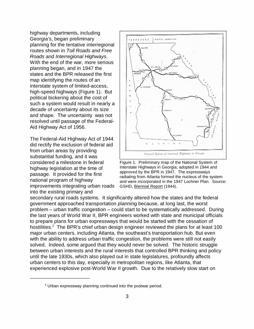
highway departments, includingGeorgia’s, began preliminaryplanning for the tentative interregionalroutes shown in Toll Roads and FreeRoads and Interregional Highways. With the end of the war, more seriousplanning began, and in 1947 thestates and the BPR released the firstmap identifying the routes of aninterstate system of limited-access,high-speed highways (Figure 1). Butpolitical bickering about the cost ofsuch a system would result in nearly adecade of uncertainty about its sizeand shape. The uncertainty was notresolved until passage of the Federal-Aid Highway Act of 1956.
The Federal-Aid Highway Act of 1944did rectify the exclusion of federal aidfrom urban areas by providingsubstantial funding, and it wasconsidered a milestone in federalhighway legislation at the time ofpassage. It provided for the firstnational program of highwayimprovements integrating urban roadsinto the existing primary andsecondary rural roads systems. It significantly altered how the states and the federalgovernment approached transportation planning because, at long last, the worstproblem – urban traffic congestion – could start to be systematically addressed. Duringthe last years of World War II, BPR engineers worked with state and municipal officialsto prepare plans for urban expressways that would be started with the cessation ofhostilities. The BPR’s chief urban design engineer reviewed the plans for at least 1002
major urban centers, including Atlanta, the southeast’s transportation hub. But evenwith the ability to address urban traffic congestion, the problems were still not easilysolved. Indeed, some argued that they would never be solved. The historic strugglebetween urban interests and the rural interests that controlled BPR thinking and policyuntil the late 1930s, which also played out in state legislatures, profoundly affectsurban centers to this day, especially in metropolitan regions, like Atlanta, thatexperienced explosive post-World War II growth. Due to the relatively slow start on
Figure 1. Preliminary map of the National System ofInterstate Highways in Georgia, adopted in 1944 andapproved by the BPR in 1947. The expresswaysradiating from Atlanta formed the nucleus of the systemand were incorporated in the 1947 Lochner Plan. Source:GSHD, Biennial Report (1944).
For a definitive overview of the origins of the federalist system of highway administration,3
Bruce Seely, Building the American Highway System: Engineers as Policy Makers (Philadelphia: TempleUniversity Press, 1987).
4
construction of urban highways, followed by the post-1965 effects of the environmentalmovement, urban highways in such cities have rarely been able to match capacity withdemand.
Getting Started
The Federal-Aid Highway Act of 1956 marks the beginning of large-scale constructionefforts on the National System of Interstate and Defense Highways. Rather thancreating the system, it is more accurate to say that this landmark legislation resolvedmajor problems related to funding a national uniform system of superhighways that hadbeen authorized in 1944 and initially mapped in 1947. Thus, the 1956 legislationculminated 20 years of thinking about highway engineering and urban trafficcongestion. Most significantly, the 1956 act established the 90% federal and 10% statefunding formula for the accelerated construction of the interstate system. That networkwas expanded in 1955 to include urban distributing and circumferential routes. The actof 1956 thus inaugurated this nation’s largest public works project that has soinfluenced people’s lives and the nation’s economy. But the federal government did notbuild the interstate highway system – the states did, each using their own approaches,policies and preferences.
Essential to understanding Georgia’s interstate highway system is the organizationaland administrative structure that guided its development. Interstate highways werebuilt under federalism, in which the national government shared power and decisionmaking with the individual states. Although the federal government paid the lion’sshare of construction costs under the 90/10 federal-aid formula, state highwaydepartments performed and oversaw the actual work of locating, designing, andbuilding the interstates, albeit to federal standards. Federal engineers approved state-prepared plans and allowed each state flexibility within the national design guidelines. As a result of the ability for variation under federalism, the historical pattern ofinterstate development differed from state to state, but every state worked within thesame general administrative framework.3
The Origin of Interstate Highways in Georgia: The Lochner Plan and AtlantaExpressway
The plan prepared in 1946 to address metro Atlanta’s traffic congestion represents thestart of the interstate highway era in Georgia. Late in 1944, the Georgia State HighwayDepartment, in cooperation with the City of Atlanta, Fulton County, and the BPR, turnedto H. W. Lochner & Company, a newly founded transportation planning firm in Chicago,
H. W. Lochner & Company and De Leuw, Cather & Company, Highway and Transportation4
Plan for Atlanta, Georgia, prepared for the State Highway Department of Georgia and the Public RoadsAdministration, Federal Works Agency (January 1946).
5
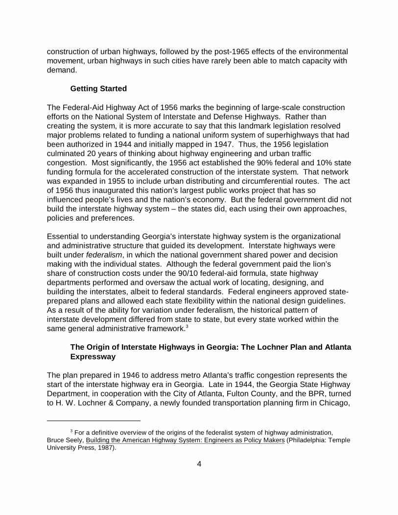
to prepare a comprehensivehighway and transportation planfor the region based on trafficsurvey data gathered by BPR andthe department from 1936 to 1945. In keeping with Toll Roads andFree Roads with its combination ofinterregional and through urbanroutes, the plan identified whatwould be the “urban portions ofthe interstate highways identifiedon the 1944 map . . . [as] majorarteries radiating from Atlantatoward Spartanburg, Chattanooga,Birmingham, Montgomery, andMacon” and a sixth arterial routetoward Augusta identified by theGeorgia State HighwayDepartment as the nucleus of thestate’s interstate highway network(Figure 2). The plan alsodeveloped that network’s mostproblematic feature – the sectionthrough downtown Atlanta thatconnects four of the six radiatingroutes. Interestingly, the radiatingexpressways were based on theexisting regional railroad networkplan and is just a later iteration ofthe historic transportation patternslaid down in the railroad era.4
The Lochner plan was hailed in the late 1940s as the solution to the worst of Atlanta'straffic congestion and safety problems, and its main component, the AtlantaExpressway, was to be the most “modern” highway ever in Georgia. The primary link ofthis radiating system of expressways was to be a below-grade, limited-accessconnector through the heart of the city and extending around the north, east, and southsides of the central business district. The goal of the plan was to locate the radiatingexpressways along existing traffic flows in order to be able to serve the greatest
Figure 2. The 1947 Lochner plan for the metro-Atlantaexpressway system showing radial freeways and downtownconnector. Source: Lochner (1947).
Ibid., pp. xiii, 14.5
Mark H. Rose and Bruce E. Seely, “Getting the Interstate System Built: Road Engineers and6
the Implementation of Public Policy, 1955-1985,” Journal of Policy History, Vol. 2, No. 1 (1990), pp. 36-7.
Sam Allison, “Atlanta Expressway to Move Rapidly During 1958,” Georgia Highways (Jan. 7
1958), n.p.; Atlanta Times (Oct. 15, 1964). The design standards used starting in 1948 did include 12'-wide travel lanes but not full shoulders or sufficient acceleration and deceleration lanes. The widemedian was quickly eliminated for additional lanes separated by a chain-link fence, and the Brookwoodinterchange between the Northeast (I-85) and Northwest (I-75) Expressways with the Connector and localstreets had sharp curves and steep grades. Between 1948 and 1952, the section from Baker Street northto Lindbergh Drive on the northeast leg and to near Paces Ferry Road on the northwest leg werecompleted as was the southern leg from University Avenue to the Clayton County line.
6
feasible number of vehicles within the urban core, as well as around it. The initialestimate was that 60% of the traffic using the connector would be local in nature, boundfor downtown. To the greatest extent possible, the routes were intended to go through“marginal neighborhoods,” and the radiating expressways were to conform to the “mostmodern highway design standards as developed by the Federal Interregional HighwayCommittee.” Such layouts reflected the thinking of most urban road builders, and5
many planners as well, since marrying road construction and “slum clearance” (laternamed urban renewal) offered the best chance of minimizing property acquisition costsfor the new highways.6
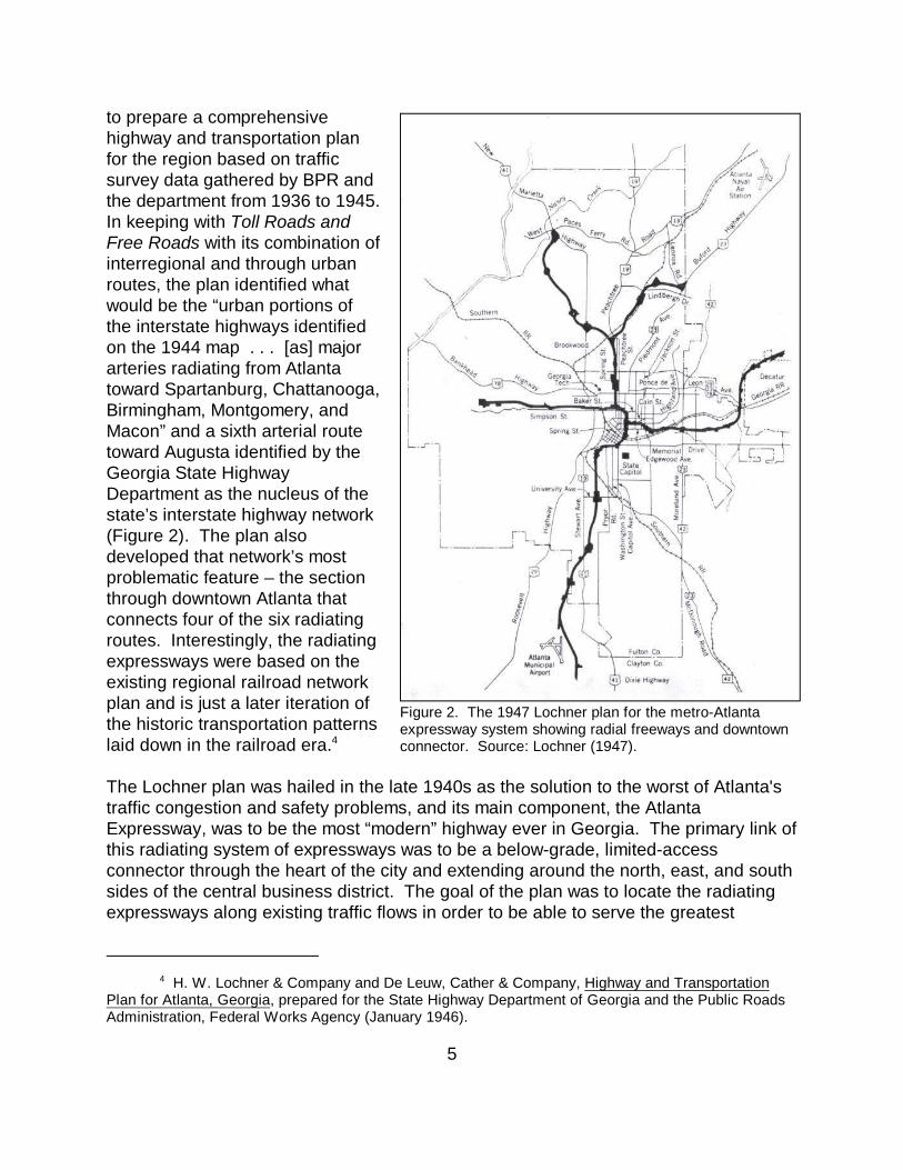
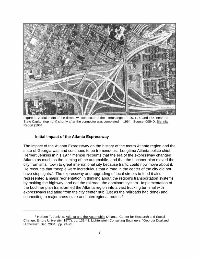
Construction on the Atlanta Expressway began in 1948 using pre-interstate highwaydesign standards, but higher than anticipated right-of-way acquisition and constructioncosts, public relations problems, and changes in the highway design stymied notableprogress for most of the years prior to 1956. There was a spurt of construction activitybetween 1948 and 1952, but the city and county had to approve an additional $12.7million in bonds to keep the project going after 1952. As many as 3,000 parcels had tobe assembled for a mile-long section of the route. Additionally there were difficult andpolitically controversial decisions to make about the alignment of the downtownconnector, and the region’s explosive growth caused the engineers to rethink theroadway geometry. Additional lanes were recommended, and that decision causedfurther delays and, of course, higher costs. By the summer of 1958, ten years afterconstruction was started, only 18 miles of the state’s premier urban project wereactually open to traffic. It was only with passage of the 1956 Federal-Aid Highway Actand its infusion of funds for interstate highways that the 1.2-mile long downtownconnector was opened in September 1964 at a cost of $33 million (Figure 3). It wasdedicated with a great fanfare, including a special expressway section in the AtlantaTimes with articles on topics like how to negotiate the connector. 7
Herbert T. Jenkins, Atlanta and the Automobile (Atlanta: Center for Research and Social8
Change, Emory University, 1977), pp. 133-41; Lichtenstein Consulting Engineers, “Georgia DualizedHighways” (Dec. 2004), pp. 24-25.
7
Initial Impact of the Atlanta Expressway
The impact of the Atlanta Expressway on the history of the metro Atlanta region and thestate of Georgia was and continues to be tremendous. Longtime Atlanta police chiefHerbert Jenkins in his 1977 memoir recounts that the era of the expressway changedAtlanta as much as the coming of the automobile, and that the Lochner plan moved thecity from small town to great international city because traffic could now move about it. He recounts that “people were incredulous that a road in the center of the city did nothave stop lights.” The expressway and upgrading of local streets to feed it alsorepresented a major reorientation in thinking about the region’s transportation systemsby making the highway, and not the railroad, the dominant system. Implementation ofthe Lochner plan transformed the Atlanta region into a vast trucking terminal withexpressways radiating from the city center hub (just as the railroads had done) andconnecting to major cross-state and interregional routes.8
Figure 3. Aerial photo of the downtown connector at the interchange of I-20, I-75, and I-85, near theState Capitol (top right) shortly after the connector was completed in 1964. Source: GSHD, BiennialReport (1964).
Metropolitan Planning Commission, Crosstown and By-Pass Expressways, Expressway Policy9
Study, Report No. 2 (June 1959), pp. 12-16.
8
Well before the downtown connector was finished in 1964, planners and engineersknew that the Atlanta Expressway, particularly the connector, had reached capacitydespite having been upgraded during construction from a four-lane to a six-lane facility. Traffic volumes on the expressway’s north leg topped 65,000 vehicles per day and8,000 vehicles per hour during the morning rush. Amazingly, the daily traffic counts in1958 were greater than the Lochner plan projection for traffic volumes in 1970 withenough traffic between Fourteenth Street and the Brookwood interchange at theevening peak to justify a 16-lane-wide roadway. The numbers were a sure sign ofcontinued traffic congestion problems ahead and the need for improvements, butcircumstances and attitudes would change making it impossible to remedy those late-1940s decisions based on the Lochner plan.9
Establishing the National System of Interstate and Defense Highways in1956
Many if not most states, including Georgia, struggled to complete their urbanexpressways. The reasons for slow progress on these desperately needed urbanhighways were many, including materials shortages, first because of inflation and thenthe Korean Conflict. State road organizations, like the Georgia State HighwayDepartment, were also challenged by a shortage of civil and structural engineers. Engineering “manpower” had been affected by the war, but even as the GI Bill led todramatic increases in student populations, many new fields of engineering (computers,materials, aviation and aerospace, nuclear power) were attracting students away fromcivil training. Thus as state construction programs geared up to meet traffic demandsand to spend the larger appropriations coming from Washington, highway departmentslike Geogia’s scrambled for enough trained engineers and bridge designers.
As demonstrated by the Atlanta Expressway, the more difficult problem was paying forthe expensive, limited-access highways. State highway department budgets simply didnot grow as fast as federal-aid allocations, which initially required a 50% state match. In addition to the urban expressways, there was much work to do to redress road andbridge maintenance that had been deferred during World War II. Many state highwaydepartments failed to claim all of their federal-aid highway funds for 1947 and 1948because they could not meet the 50/50 match, leaving an unobligated backlog of morethan $500 million. That prompted President Harry S. Truman to eliminate all federal-aid highway funds from the 1949 budget and to propose sharp reductions in theappropriations for 1950 and 1951.
One solution to paying for superhighways was toll financing. The success of thePennsylvania Turnpike, which opened in 1940, illustrated that motorists and truckers
“What’s Right with the Interstates,” Engineering News-Record, Vol. 165 (Aug 25, 1960), pp. 24-10
25).
9
were willing to pay for the convenience of faster, limited-access highways, and that tollscould generate sufficient revenue to pay off the construction bonds. In 1945, New Yorkproposed a toll thruway across the state, while Maine actually opened the first postwar turnpike in 1947. In 1947 New York officially created the Thruway Commission, andother states like New Hampshire, West Virginia, New Jersey and Maryland followedsuit. By 1953, 762 miles of toll road had opened, with another 1,077 miles underconstruction, mostly in the Northeast and Midwest. The peak year of turnpikeconstruction came in 1954. Georgia lawmakers, like those in most southern states,discussed toll financing but did not authorize turnpikes.
That so many states resorted to toll financing was a clear indication of serious disarrayin the nation’s highway policy in the late 1940s and early 1950s. Highway and motorvehicle lobbying groups ever more loudly demanded improvements for every type ofroad, from main routes between cities to secondary roads and the new interstate system. But Congress, distracted first by the challenges of returning to peacetime, andthen by the cost of meeting the demands of the Cold War, could not agree on how toresolve the impass. While the 1950 and 1952 highway appropriation bills totaled $550million and $575 million respectively, there was no solution to the problems statesfaced providing the required 50% match for those larger amounts.
After years of congressional squabbling and public insistence on the need for buildinga better national highway system, the federal legislation establishing the NationalSystem of Interstate and Defense Highways finally passed in 1956. The Federal-AidHighway Act of 1956 set up programs to build the interstate highway system and at thesame time increase allocations for construction of other categories of federal-aidhighways to more than $800 million per year after 1956. All were to be funded by usertaxes locked in the Highway Trust Fund. The most significant aspect of the 1956 actwas that the federal government agreed to provide 90% of the cost of interstatehighways, the step that finally provided the money states needed to make real progresson a network of those very expensive, high-standard, express highways between andinto the nation’s cities. In 1958 it was estimated that urban mileage constituted 11% ofthe total interstate highway system, but that its construction would require 42% of thefunding.10
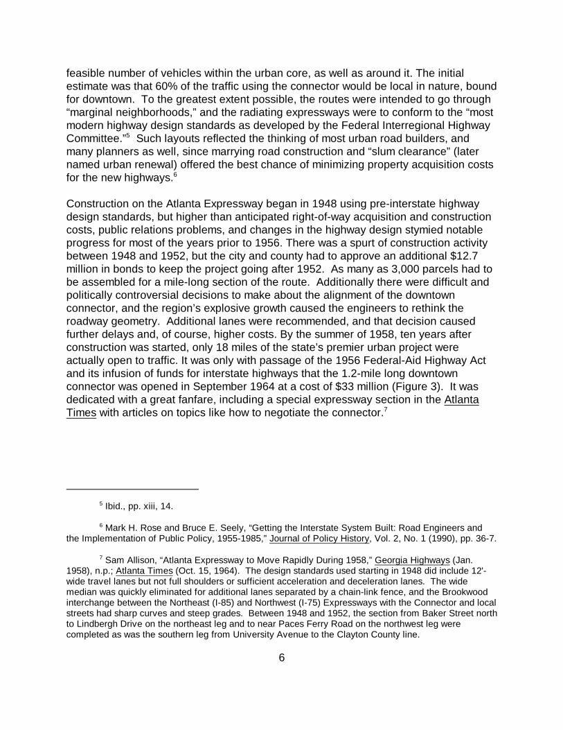
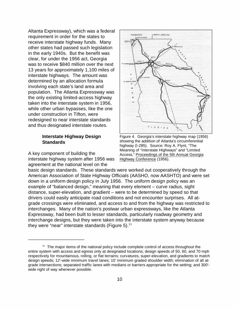
With the passage of the 1956 act, the states launched the largest highway constructionprogram in history. In 1955, in recognition of the traffic congestion that was grippingAmerican cities, circumferential and distributing highways, like metro Atlanta’s I-285perimeter road, had been added to the interstate system (Figure 4). That was also theyear that the Georgia legislature belatedly passed an act allowing for limited-accesshighways (previously permitted only in Fulton County to facilitate construction of the
The major items of the national policy include complete control of access throughout the11
entire system with access and egress only at designated locations; design speeds of 50, 60, and 70 mphrespectively for mountainous, rolling, or flat terrains; curvatures, super-elevation, and gradients to matchdesign speeds; 12'-wide minimum travel lanes; 10' minimum graded shoulder width; elimination of all at-grade intersections; separated traffic lanes with medians or barriers appropriate for the setting; and 300'-wide right of way whenever possible.
10
Altanta Expressway), which was a federalrequirement in order for the states toreceive interstate highway funds. Manyother states had passed such legislationin the early 1940s. But the benefit wasclear, for under the 1956 act, Georgiawas to receive $840 million over the next13 years for approximately 1,100 miles ofinterstate highways. The amount wasdetermined by an allocation formulainvolving each state’s land area andpopulation. The Atlanta Expressway wasthe only existing limited-access highwaytaken into the interstate system in 1956,while other urban bypasses, like the oneunder construction in Tifton, wereredesigned to near interstate standardsand thus designated interstate routes.
Interstate Highway DesignStandards
A key component of building theinterstate highway system after 1956 wasagreement at the national level on thebasic design standards. These standards were worked out cooperatively through theAmerican Association of State Highway Officials (AASHO, now AASHTO) and were setdown in a uniform design policy in July 1956. The uniform design policy was anexample of “balanced design,” meaning that every element – curve radius, sightdistance, super-elevation, and gradient – were to be determined by speed so thatdrivers could easily anticipate road conditions and not encounter surprises. All at-grade crossings were eliminated, and access to and from the highway was restricted tointerchanges. Many of the nation’s postwar urban expressways, like the AtlantaExpressway, had been built to lesser standards, particularly roadway geometry andinterchange designs, but they were taken into the interstate system anyway becausethey were “near” interstate standards (Figure 5).11
Figure 4. Georgia’s interstate highway map (1956)showing the addition of Atlanta’s circumferential highway (I-285). Source: Roy A. Flynt, “TheMeaning of “Interstate Highways” and “LimitedAccess,” Proceedings of the 5th Annual GeorgiaHighway Conference (1956).
11
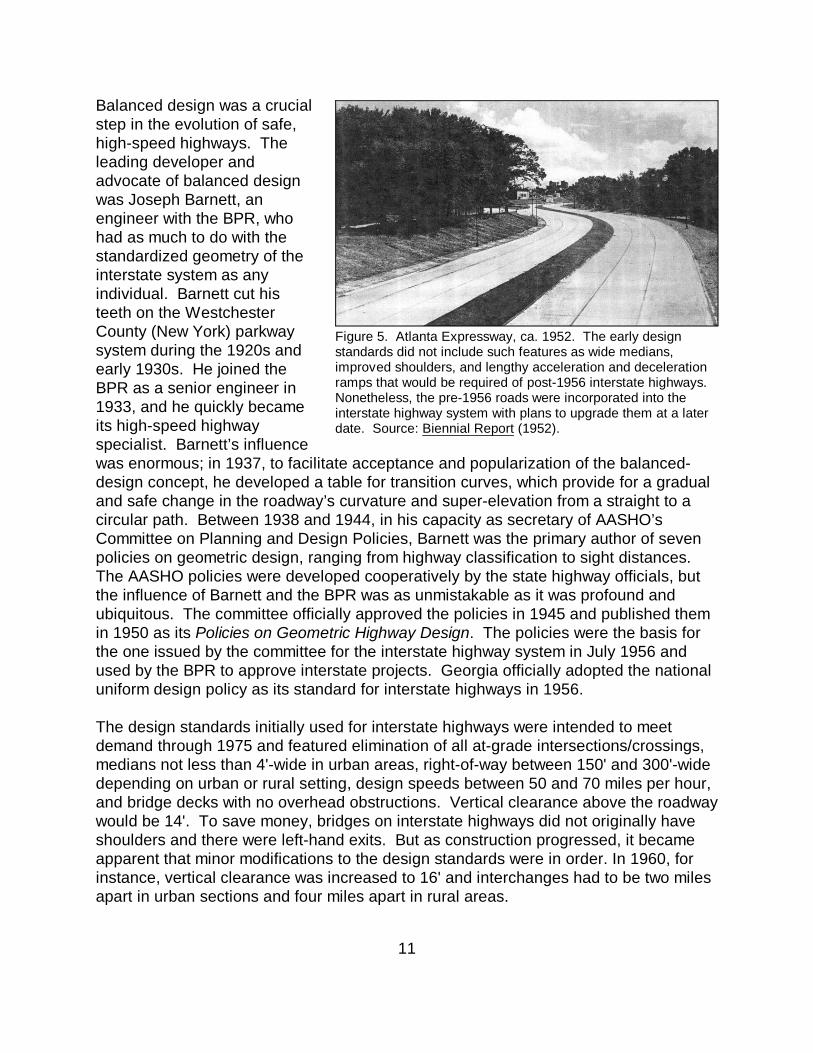
Balanced design was a crucialstep in the evolution of safe,high-speed highways. Theleading developer andadvocate of balanced designwas Joseph Barnett, anengineer with the BPR, whohad as much to do with thestandardized geometry of theinterstate system as anyindividual. Barnett cut histeeth on the WestchesterCounty (New York) parkwaysystem during the 1920s andearly 1930s. He joined theBPR as a senior engineer in1933, and he quickly becameits high-speed highwayspecialist. Barnett’s influencewas enormous; in 1937, to facilitate acceptance and popularization of the balanced-design concept, he developed a table for transition curves, which provide for a gradualand safe change in the roadway’s curvature and super-elevation from a straight to acircular path. Between 1938 and 1944, in his capacity as secretary of AASHO’sCommittee on Planning and Design Policies, Barnett was the primary author of sevenpolicies on geometric design, ranging from highway classification to sight distances. The AASHO policies were developed cooperatively by the state highway officials, butthe influence of Barnett and the BPR was as unmistakable as it was profound andubiquitous. The committee officially approved the policies in 1945 and published themin 1950 as its Policies on Geometric Highway Design. The policies were the basis forthe one issued by the committee for the interstate highway system in July 1956 andused by the BPR to approve interstate projects. Georgia officially adopted the nationaluniform design policy as its standard for interstate highways in 1956.
The design standards initially used for interstate highways were intended to meetdemand through 1975 and featured elimination of all at-grade intersections/crossings,medians not less than 4'-wide in urban areas, right-of-way between 150' and 300'-widedepending on urban or rural setting, design speeds between 50 and 70 miles per hour,and bridge decks with no overhead obstructions. Vertical clearance above the roadwaywould be 14'. To save money, bridges on interstate highways did not originally haveshoulders and there were left-hand exits. But as construction progressed, it becameapparent that minor modifications to the design standards were in order. In 1960, forinstance, vertical clearance was increased to 16' and interchanges had to be two milesapart in urban sections and four miles apart in rural areas.
Figure 5. Atlanta Expressway, ca. 1952. The early designstandards did not include such features as wide medians,improved shoulders, and lengthy acceleration and decelerationramps that would be required of post-1956 interstate highways. Nonetheless, the pre-1956 roads were incorporated into theinterstate highway system with plans to upgrade them at a laterdate. Source: Biennial Report (1952).
For a history of the Georgia Department of Transportation through 1956, please refer to the12
modern roadways chapter in the Development of Transportation Networks in Georgia section of theDepartment’s Historic Bridge Inventory Update Historic Contexts (June 2001) by Lichtenstein ConsultingEngineers, Inc.
Georgia State Highway Department (GSHD), Biennial Reports, 1920-1956; Proceedings of the13
7th Annual Georgia Highway Conference (1958), p. 166; Douglas Hudson, Personal communication withMary McCahon (LCE), April 2006.
12
Georgia Interstate Construction 1956-1973
When Congress finally passed legislation in 1956 that provided the mechanism foraccelerated construction of the interstate highway system, many of the administrativeand technical pieces needed to tackle the herculean task of planning, designing andconstructing Georgia’s 1,100 miles of interstate highway were already in place or wereabout to be implemented. The Georgia State Highway Department had beenestablished in 1916 to administer federal aid, and in 1920, it had established the bridgedivision with the brilliant Searcy B. Slack from LaGrange as the state’s first state bridgeengineer. Like state highway departments all across the country, the Georgia State12
Highway Department had also positioned itself to address challenges of building urbanexpressways since the late 1930s, when federal aid was extended to include urbanroads as well as upgrading existing roads. The Division of Highway Planning headedby Roy A. Flint was established in 1936 to conduct traffic counts, economicinvestigations and fiscal studies that supported the proposed location of those urbanroads. It also obtained data on truck weights and prepared highway maps. TheDivision of Right of Way was created in 1944 to handle acquisition of right of way inadvance of the construction program. Division engineer R. E. Adams noted that hisgreatest concern in complying with the federal-aid program was securing the necessary200'- to 300'-wide right of ways preferred by federal engineers for dualized highwaysand urban expressways, and personnel in the division increased from 15 men in 1954to 70 just four years later in 1958. The Division of Urban Projects headed by S. P.Allison was created in the summer of 1947 for projects using federal-aid urban funds. The Division of Public Relations was established in the fall of 1956, ostensibly to dealwith right of way acquisition problems. One of its initial efforts was the monthlypublication of Georgia Highways, a 20-page magazine that stressed the politicalneutrality of the engineer but only continued for one year in 1958. The bridge divisioncontinued its well-established tradition of identifying which materials, designs, anddetails would provide the state with the most efficient and economical bridges. In themid 1950s, it developed its own designs for shear details to make rolled beams andconcrete decks composite.13
The Department used technology to increase the ability of its cadre of designers toprovide the plans needed for the expanding highway programs of the 1950s,particularly the large volume of work needed for the interstate highways. One of the
GSHD, Biennial Report (1958), p. 103.14
Russell Chapman, Personal communication with Mary McCahon (LCE), April 2006.15
Hudson, April 2006.16
13
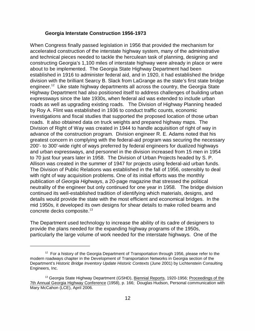
most important tools in efficientlylocating and designing new highwayswas photogrammetry, an aerialmapping technique that relied upontwo cameras in an airplane toproduce images that, when viewedtogether, created stereo images thatcould be turned into accurate plansand drawings (Figure 6). This photoequipment affected large economiesin construction costs and engineeringmanpower required for the interstatehighways for both location andspecific design problems. Thedepartment purchased its own planein 1953 and led all southeasternstates in use of photogrammetry.14
Georgia was one of the first states to utilize the timesaving advantages of computers inbridge and highway design. By 1957, the department was using a computer, the IBM650, to solve earthwork and bridge design problems. Bridge engineer RussellChapman, who started with the department in 1947 and served as state bridgeengineer from 1968 until 1974 when he became a preconstruction engineer, went toprogrammer school and developed programs that solved geometry problems and thedesign of continuous beams with variable moments of inertia. The advantage of thecomputer was that it could accomplish big calculation problems quickly. The bridge15
division was constantly studying new bridge types and designs to determine if theywere more economical. Types and designs that were studied included the continuousreinforced concrete T beam design favored in Alabama and the cast-in-place post-tensioned box beam bridge that worked so well for Florida DOT. Neither, however,proved to be more economical than rolled steel stringer bridges, which was usedalmost exclusively on the interstates until the mid 1970s.16
Use of technologies like photogrammetry and computer-generated calculations,coupled with greater reliance on standard bridge and roadway designs, greatly assistedthe state highway department’s goal to produce the plans for the interstate highwaysand their associated bridges as fast as possible. Uniformity and standardization werethe names of the game in Georgia as in most of the country. Indeed, the adoption of
Figure 6. Georgia State Highway Department employeesload a camera on the department’s airplane. Aerialphotography eliminated the need for labor intensiveground surveys and was one of the new technologiesemployed to improve the efficiency of locating anddesigning interstate highways. Source: GeorgiaHighways (Jan. 1958).
GSHD, Biennial Report (1958), pp. 101, 105.17
Emory Parrish, Personal communication with Mary McCahon (LCE), April 2006.18
14
standard drawings and specifications simplified the process of getting the approval ofthe federal highway bureaucracy, since there were few variations to be concernedabout and inspected.
Construction Begins on I-Designated Highways
Passage of the Federal-Aid Highway Act of 1956 meant that in addition to applying the90/10 funding formula to dualized highways like the Atlanta Expressway already underconstruction, work could now begin locating and designing all the interstate routesidentified on the 1944 map and the 63.3-mile-long circumferential loop around Atlanta(I-285) added to the system in 1955. The precise alignments of the interstate highwaysin Georgia were generally not influenced by politics and reflected the originalagreements between the BPR and the state in 1944 with the exception of I-85 east ofSuwanee. Its route to Greenville, SC was changed from through Gainesville to itspresent route via Lavonia, the hometown of Ernest Vandiver, governor from 1959 to1963.
Initially progress was slow and was focused on survey, property acquisition, anddesign. While specific interstate routes had been approved, they had not beenspecifically located, so surveying dominated initial efforts. By the middle of 1958, 776miles of Georgia’s 1,100 interstate miles had been surveyed, while plans werecompleted for 32 miles with another 200 miles in various stages of completion.17
Dualized (but not limited access) highway plans in hand when the act was signed inJune of 1956, like those for the Tifton Bypass, required extensive revisions to bringthem up to or near interstate design standards. The 5-mile-long Tifton Bypass, which iscommonly but erroneously held as the first section of interstate constructed using an “I”designation in Georgia, was actually started in 1953 using 40/60 funding. When it wastaken into the interstate system as part of I-75, it was brought up to interstate standardsby adding a frontage road in order to make the dualized highway section limitedaccess. The first section of highway to be let with an “I” designation, and thus could beconsidered the “first” section of interstate built as such in Georgia, was the nearby 3.3-mile-long Forsyth Bypass that was let in December of 1956 and completed by the endof 1958.18
The design and construction of the original interstate routes (I-16, I-20, I-75, I-85, I-95,and I-285) were broken into short-mileage sections and then designed and letincrementally (Figure 7). Work proceeded on both urban and rural segments in thispiecemeal fashion through the early 1970s with segments opened to traffic as theywere completed. When one segment was let, work would begin on preparing the plansfor the next segment as funds became available. Work continued on the Atlanta
GSHD, Biennial Report (1966), p. 101.19
Parrish, Apr. 2006.20
15
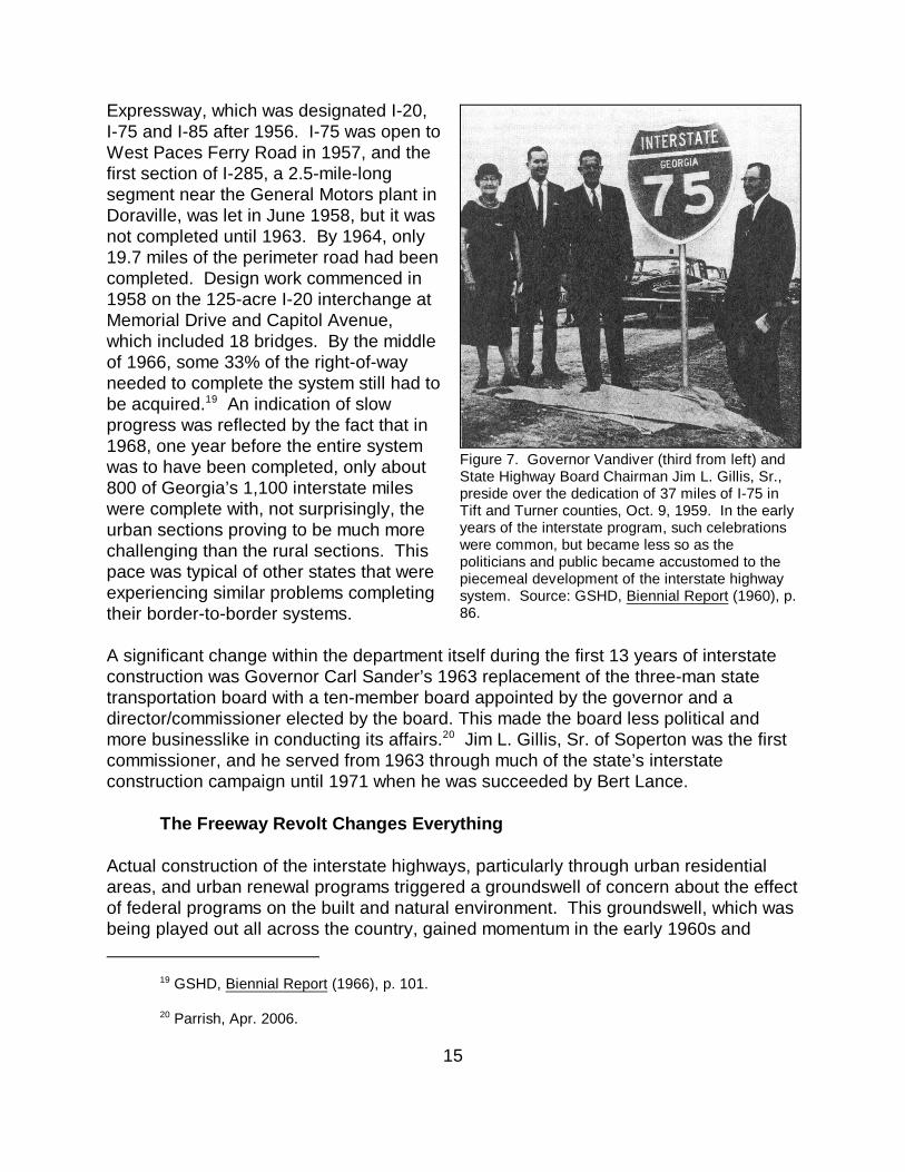
Expressway, which was designated I-20,I-75 and I-85 after 1956. I-75 was open toWest Paces Ferry Road in 1957, and thefirst section of I-285, a 2.5-mile-longsegment near the General Motors plant inDoraville, was let in June 1958, but it wasnot completed until 1963. By 1964, only19.7 miles of the perimeter road had beencompleted. Design work commenced in1958 on the 125-acre I-20 interchange atMemorial Drive and Capitol Avenue,which included 18 bridges. By the middleof 1966, some 33% of the right-of-wayneeded to complete the system still had tobe acquired. An indication of slow19
progress was reflected by the fact that in1968, one year before the entire systemwas to have been completed, only about800 of Georgia’s 1,100 interstate mileswere complete with, not surprisingly, theurban sections proving to be much morechallenging than the rural sections. Thispace was typical of other states that wereexperiencing similar problems completingtheir border-to-border systems.
A significant change within the department itself during the first 13 years of interstateconstruction was Governor Carl Sander’s 1963 replacement of the three-man statetransportation board with a ten-member board appointed by the governor and adirector/commissioner elected by the board. This made the board less political andmore businesslike in conducting its affairs. Jim L. Gillis, Sr. of Soperton was the first20
commissioner, and he served from 1963 through much of the state’s interstateconstruction campaign until 1971 when he was succeeded by Bert Lance.
The Freeway Revolt Changes Everything
Actual construction of the interstate highways, particularly through urban residentialareas, and urban renewal programs triggered a groundswell of concern about the effectof federal programs on the built and natural environment. This groundswell, which wasbeing played out all across the country, gained momentum in the early 1960s and
Figure 7. Governor Vandiver (third from left) andState Highway Board Chairman Jim L. Gillis, Sr.,preside over the dedication of 37 miles of I-75 inTift and Turner counties, Oct. 9, 1959. In the earlyyears of the interstate program, such celebrationswere common, but became less so as thepoliticians and public became accustomed to thepiecemeal development of the interstate highwaysystem. Source: GSHD, Biennial Report (1960), p.86.
Metropolitan Planning Commission, Crosstown and By-pass Expressways, Expressway Policy21
Study, Report Number Two (June 1959), p. ii.
16
culminated in passage of precedent-setting environmental legislation starting in 1966. The new laws established procedures for transportation agencies to consider theimpact of their projects on everything from minority employment requirements to theeffect on historic buildings, and the laws permitted the public and affected parties toparticipate in that process. Local groups that had been battling the department duringthe 1960s over expressways planned for the eastern side of Atlanta used the newlyenacted federal environmental laws in the early 1970s to stop construction of I-485 andthe Stone Mountain Freeway. Both were important sections of the proposedintermediate loop-east that had been envisioned since the early 1950s as a way torelieve congestion on the downtown connector.
Long-Recognized Limitations of the Lochner Plan
That the connector (I-75/I-85) was inadequate was apparent by the early 1950s asAtlanta experienced unprecedented growth. In 1952, the Metropolitan PlanCommission (MPC), predecessor to the Atlanta Regional Commission (ARC), called forexpanding the Lochner Plan of radiating expressways from the city core by addinginner and outer loop highways. Ambitious as that plan may have seemed in 1952,21
passage of the Federal-Aid Highway Act of 1956 made augmentation of the city’sexpressway network possible, and the outer loop, intended to tie together the then-sparse but fast-growing suburban centers and to bypass the urban core, wasprogrammed as I-285 in 1955. The proposed inner loop was not programmed as partof the original interstate system, but it would be added in time.
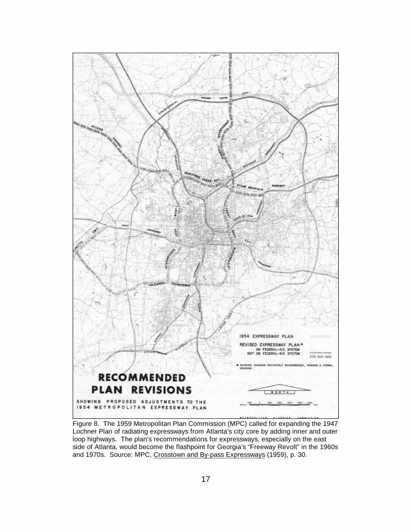
The MPC’s 1959 plan, Crosstown and By-pass Expressways, reexamined the need forthe envisioned but as yet unprogramed urban expressways. It also considered alternative modes of transportation. Even with the 63-mile-long outer loop (I-285), thestudy recommended about 104 more miles of freeways in the metro region, includingthe inner loop (now dubbed the intermediate loop) and a new, much-needed northexpressway (the Roswell Expressway/GA 400). The most controversial of the 1959recommendations proved to be the intermediate loop (east) that would link with theproposed Roswell Expressway at its northern terminus and the Lakewood Expresswaynear the federal penitentiary at its south end. There were to be major interchangeswith I-20 and Ponce de Leon Avenue. This route, which was distilled from similar loopfreeways proposed in the 1952 and 1954 plans, was seen as best for achieving twogoals; taking through traffic off the connector and linking right-of-way acquisition andredevelopment with urban renewal in what were considered “blighted neighborhoods”in East Altanta (Figure 8). Regardless of alignment, the intermediate loop (east) wasgoing to affect some of Atlanta’s oldest residential neighborhoods, making the
17
Figure 8. The 1959 Metropolitan Plan Commission (MPC) called for expanding the 1947Lochner Plan of radiating expressways from Atlanta’s city core by adding inner and outerloop highways. The plan’s recommendations for expressways, especially on the eastside of Atlanta, would become the flashpoint for Georgia’s “Freeway Revolt” in the 1960sand 1970s. Source: MPC, Crosstown and By-pass Expressways (1959), p. 30.
Ibid., p. 31.22
U.S. Department of Transportation, Federal Highway Administration, America’s Highways23
1776-1976: A History of the Federal Aid Program (Washington, DC: 1976), p. 371.
18
proposed eight-lane-wide facility one of the most expensive highway projects in thestate. 22
A critical 5.2-mile-long segment of the intermediate loop (east) was formally added tothe interstate system in 1965 as I-485. It broke out from the downtown connector atBoulevard and passed through inner city neighborhoods like Candler Park, Inman Parkand Morningside to Lindbergh Drive/Cheshire Bridge Road and I-85, where it wouldalso connect with the proposed Roswell Expressway. Another 5.3-mile-longexpressway was proposed across Decatur and Druid Hills to link with the StoneMountain Freeway on the east side of I-285. That road was to meet I-485 at a 120-acreinterchange near the present intersection of North Avenue and Barnett Street in theVirginia Highlands neighborhood. Local opposition to both expressways wasimmediate and strong.
By the early 1960s, the demolition and displacement occurring in American cities as aresult of interstate highway construction spawned a dramatic change in the public’sattitude toward engineers as policy makers. The once-trusted transportation engineersand the agencies for whom they worked were increasingly questioned by a public thatwas turning to city halls, state houses, the courts, and Congress to press their opinions. Through the 1960s engineers watched as their long-held position as the expert,apolitical decision makers was eroded. Steadily, decisions once controlled almostexclusively by engineers began to be made with input from others. The actual controlof decisions began to shift from the engineering arena. While public hearings for theurban bypass and then intra-urban highways were required under the federal-aidhighway acts of 1950 and 1956, and then extended to interstate highway projects in1958, these rules did not suggest meaningful input was solicited or that it had an effecton engineering decision making. In 1962, however, in response to ever-increasingpublic and political pressure, BPR tied federal-aid funds to a requirement that citieswith a population greater than 750,000 prepare long-term, multi-modal, comprehensiveregional transportation plans. Funds would be withdrawn after 1965 if a city did notcomply.23
Then, in recognition of the fact that the nation’s cities could not build enough highwaylanes to solve their traffic congestion problems, Congress passed the Urban MassTransportation Act in 1964 for construction of mass transit systems. Allocated fundswere initially limited, but two years later, in 1966, funding for both construction andoperation of mass transit systems was to be provided by the Highway Trust Fund –another blow to the influence of highway engineers who now saw their once-exclusivefunding source shared with fixed rail systems.
There were several federal agencies that managed the nation’s highway programs before24
1967. The original agency was the Office of Road Inquiry established in the Department of Agriculture in1893. While in the Department of Agriculture the agency changed its name four times. In 1899 itbecame the Office of Public Road Inquiries, in 1905 it became the Office of Public Roads, in 1915 itchanged to the Office of Public Roads and Rural Engineering, and in1918 it was the Bureau of PublicRoads (BPR), which it remained through 1966. BPR was moved to the Federal Works Agency in 1939and renamed the Public Roads Administration. In 1949, the BPR name was restored and the agencywas put under the Department of Commerce where it remained until the Federal Highway Administrationwas established within the Department of Transportation in 1967.
“H’wy Board Opposes New Federal Regulations,” Survey, Vol. 3, No. 12 (Dec. 1968), p. 2.25
19
In 1966, just ten years after the federal legislation initiating construction of the greatnational system of high-speed, limited-access highways, Congress passed two piecesof legislation that illustrated just how different the climate had become for transportationengineers and agencies trying to complete the interstate system as originallyenvisioned. One was the National Historic Preservation Act (NHPA) that gave standingto those concerned about changes to historic properties and provided a process forthem to comment, which is codified in Section 106 of the act. The other was the USDOT Act of 1966 that, to better administer the multi-modal character of transportation,created the Department of Transportation from 30 different federal transportation-related agencies. The BPR became the Federal Highway Administration (FHWA) in1967, and mass transit moved to the Urban Mass Transit Administration (UMTA).24
The US DOT Act of 1966 also made a strong commitment to preservation of the scenicand built environment by restricting all US DOT agencies from using certain types ofproperties, including publicly owned park or recreation land, wildlife refuges andhistoric properties, as part of building their projects unless no other prudent andfeasible alternative existed. Because so many highways involved demolishing historicbuildings and taking land from parks, this provision, known today as section 4(f),significantly altered interstate highway construction programs all across the country. Italso forced state and federal transportation officials to now consider and reflect theperspectives and values of many stakeholders, particular affected citizens and electedofficials.
In 1968, federal highway legislation strengthened the long-standing policy on publichearings, now requiring them for both the location and design phases of all federal-aidprojects not yet actually under construction, including those for which right-of-way hadbeen acquired. In Georgia that included I-485 and the Stone Mountain Freewaythrough Decatur and Druid Hills, two projects that had been highly controversial sincethe early 1960s. The department went on record opposing the policy because of theperception that it would delay projects.25
John York, “I-485 All Tied Up in Controversy,” Atlanta Journal (Aug. 19, 1973), p. 19-A.26
FHWA gave states several options for dealing with sections of interstate highway that could27
never be constructed. The one Georgia selected was to substitute different projects that could beconstructed. Those included I-175 (Albany Connector), I-420 (Lakewood Extension), and I-675 (SouthAltanta Freeway). Some states returned funds, and those returned funds would come back to factorsignificantly in Atlanta.
20
The 1960s groundswell of concern about what was happening to the environmentculminated in passage in December 1969 of the National Environmental Policy Act(NEPA). It was signed into law by President Richard M. Nixon on January 1, 1970. NEPA enunciated for the first time a broad and overarching national policy towardpreventing environmental degradation by federal actions. Federal agencies were nowrequired to consider the consequences of their actions on the environment, bothnatural and manmade. Detailed, multidisciplinary, written assessments calledenvironmental impact statements (EIS) were to be prepared for all substantial federalactivities, like constructing new highways. The EIS included addressing the provisionsof the NHPA and the US DOT Act of 1966.
Understanding how the freeway revolt played out in Georgia is instructive toappreciating the climate of the times and its lasting consequences. Most highwayengineering bureaucracies in the United States resisted these changes, consideringthem sources of inefficiency and delay. Many did not grasp the political dynamicsunderlying all of the legislative acts, and this, in turn, added fuel to what came to becalled the “freeway revolt.” In Atlanta, the new laws threatened nearly 20 years ofplanning that had sought to redress deficiencies of the Lochner Plan. Then about1970, a Morningside neighborhood group brought suit against the department to forceimplementation of the newly passed NEPA and to address FHWA’s policies ofaddressing neighborhood integrity and multimodal solutions to urban traffic congestion. In 1971 the group prevailed in federal court, and I-485 was put on hold until thedepartment could complete an EIS, including assessment of the proposed MARTArapid transit lines through the northeast corridor.
When the EIS was submitted early in 1973, it was rejected by US DOT because themass transit component was insufficient. Citizens continued to work the political side ofthe equation, and the Atlanta Board of Aldermen voted against the proposedexpressway on June 18, the same day the EIS was rejected by US DOT. The fate of I-485 was not known for certain until the Atlanta Regional Commission (ARC) revised itsAltanta Area Transportation Study (AATS). The 1974 revision called for deleting I-26
485 (which ARC had endorsed as part of the 104 miles of new urban expresswaysincluded in its 1969 AATS). With that decision the State Transportation Board voted towithdraw the mileage from the interstate system, and FHWA accepted the withdrawal in1975. In 1977, I-485 had come full circle as GADOT moved to dispose of all of the27
“Houses Rise from the Ashes of I-485,” Atlanta Journal (May 10, 1981), p. C-8.28
US DOT, FHWA and GADOT, “Final Environmental Impact Statement, Georgia Project M-29
9152(2), Fulton/Dekalb Counties (May 22, 1984).
Parrish, Apr. 2006.30
21
property that it had acquired for construction and cleared north of St. Charles. Thearea has been largely redeveloped for residential use.28
The Stone Mountain Freeway shared a similar fate. In 1972, Governor Jimmy Carterappointed a commission to study the issues associated with the highly divisive projectthat would cut across viable historic neighborhoods and impact schools and the localscience center. The commission argued that building the expressway was anirreversible action while the reversible step it recommended was to wait for theassessment of the impact of the proposed MARTA lines in accordance with FHWAguidance. Governor Carter accepted the commission’s recommendation late in 1972,29
and his action meant that the Stone Mountain Freeway, like I-485 with which it was toconnect, was no longer a viable option for GADOT because of environmentalconsiderations. Again, transportation decisions were being driven by preservation andother issues. Other segments of interstate routes were also affected by environmentaland political considerations, including former mayor Maynard Jackson’s position that I-675 linking I-20 with I-75 through southeast Atlanta would never be built. Largely as a30
result of federal environmental legislation, only 32 miles of the 104 miles of urbanfreeways proposed during the 1950s and 1960s were ever built. Anotherenvironmentally and politically derived decision was that I-75 northwest of Atlantawould not cross Lake Allatoona. Its alignment was finally settled on the west side ofthe lake close to Cartersville to mollify politicians and environmentalists.
Constructing interstate highways to and through other cities in Georgia, like Macon,Columbus, Augusta, and Savannah, were not nearly as problematic as in Altanta for avariety of reasons, including that those cities’ circumferential and distributing routeswere not part of the original interstate system or, as in the case of Macon, the interstateroutes through the city proper had been constructed prior to the freeway revolt andfederal environmental laws.
The Moreland Era, 1973-87
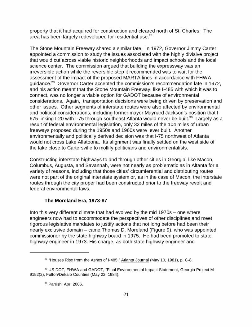
Into this very different climate that had evolved by the mid 1970s – one whereengineers now had to accommodate the perspectives of other disciplines and meetrigorous legislative mandates to justify actions that not long before had been theirnearly exclusive domain – came Thomas D. Moreland (Figure 9), who was appointedcommissioner by the state highway board in 1975. He had been promoted to statehighway engineer in 1973. His charge, as both state highway engineer and
GADOT, Annual Report (1975), pp. 6-7.31
22
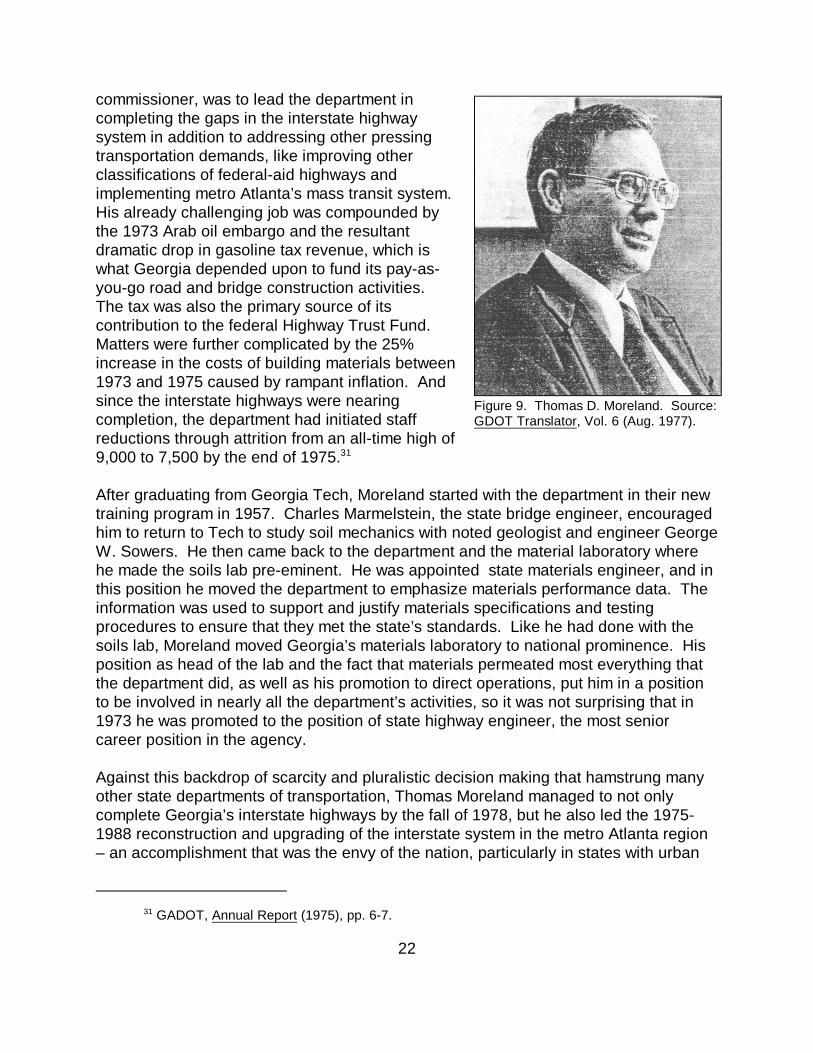
commissioner, was to lead the department incompleting the gaps in the interstate highwaysystem in addition to addressing other pressingtransportation demands, like improving otherclassifications of federal-aid highways andimplementing metro Atlanta’s mass transit system. His already challenging job was compounded bythe 1973 Arab oil embargo and the resultantdramatic drop in gasoline tax revenue, which iswhat Georgia depended upon to fund its pay-as-you-go road and bridge construction activities. The tax was also the primary source of itscontribution to the federal Highway Trust Fund. Matters were further complicated by the 25%increase in the costs of building materials between1973 and 1975 caused by rampant inflation. Andsince the interstate highways were nearingcompletion, the department had initiated staffreductions through attrition from an all-time high of9,000 to 7,500 by the end of 1975.31
After graduating from Georgia Tech, Moreland started with the department in their newtraining program in 1957. Charles Marmelstein, the state bridge engineer, encouragedhim to return to Tech to study soil mechanics with noted geologist and engineer GeorgeW. Sowers. He then came back to the department and the material laboratory wherehe made the soils lab pre-eminent. He was appointed state materials engineer, and inthis position he moved the department to emphasize materials performance data. Theinformation was used to support and justify materials specifications and testingprocedures to ensure that they met the state’s standards. Like he had done with thesoils lab, Moreland moved Georgia’s materials laboratory to national prominence. Hisposition as head of the lab and the fact that materials permeated most everything thatthe department did, as well as his promotion to direct operations, put him in a positionto be involved in nearly all the department’s activities, so it was not surprising that in1973 he was promoted to the position of state highway engineer, the most seniorcareer position in the agency.
Against this backdrop of scarcity and pluralistic decision making that hamstrung manyother state departments of transportation, Thomas Moreland managed to not onlycomplete Georgia’s interstate highways by the fall of 1978, but he also led the 1975-1988 reconstruction and upgrading of the interstate system in the metro Atlanta region– an accomplishment that was the envy of the nation, particularly in states with urban
Figure 9. Thomas D. Moreland. Source:GDOT Translator, Vol. 6 (Aug. 1977).
Paul Liles, Personal communication with Mary McCahon (LCE), Sept. 2006.32
George Busbee (1927-2004) was the first Georgia governor to serve two consecutive terms;33
1975-1983. When he was first elected governor in 1974, the state constitution did not permit a governorto succeed himself; governors were not permitted consecutive terms. Largely because of GovernorBusbee’s effective administration, the Georgia constitution was amended in 1976 to permit a governor tosucceed himself for an additional four-year term. When the intention of completing the gaps in theinterstate highway system during his administration was set, that he would serve two terms was notknown.
Liles, Sept. 2006.34
Moreland’s definition of “finished” in 1973 was having all of sections under contract, not35
necessarily done. Moreland to State Highway Board, Nov. 30, 1973 in GADOT, Commissioner Records,State Archives of Georgia, Atlanta.
23
centers that had experienced tremendous growth after World War II. Under hisleadership the department adapted to the new realities of the changing attitudes andpolicies of the times and found innovative and effective ways to get business done. Infact, Georgia’s transportation department began to move at an accelerated rate thatdrew national attention. Moreland pushed Georgia’s highway system to the forefrontnationally by being a capable decision maker, politically and technically savvy, andabsolutely dedicated to getting as much out of every federal dollar as he could. 32
Enjoying the confidence and trust of progressive Governor George Busbee, he33
worked closely and effectively with the state legislature, the congressional delegation,and the department’s federal partners at FHWA to leverage federal money, withoutwhich Georgia would not have accomplished what it did.
Moreland’s transformation of the department started when he became state highwayengineer in 1973. He moved research to the materials lab and then used the data tosupport and defend decisions from material specifications to department policies. Forinstance, rather than relying on outside contractors, he had department personnel learnto perform their own welding inspections, making the lab a national leader in thatarea. Perhaps his greatest change was a plan to complete the gaps in the state’s34
interstate highway system (some 23% of the total mileage) by the end of fiscal year1979. Moreland stated that it could be done because of the capabilities of thedepartment but only if financing could keep pace with the department’s preconstructionactivities.35
Even more changes occurred when Thomas Moreland became commissioner in thespring of 1975. The biennial report, previously a traditionally dry report, took on thelook of public relations material appropriate to a general audience with each issuebased on a theme and containing quantitative summary information and catchygraphics. The department was reorganized into five operating divisions (planning andprogramming, administration, operations, preconstruction, and construction) thatreflected the linear progression of how projects were advanced.
Emory Parrish retired in 1982.36
Moreland to Broome, Nov. 11, 1973. Letter in GADOT, Commissioner Files, State Archives.37
24
The story of Moreland’s successful tenure as commissioner represents more than theaccomplishments of one man. He benefitted from a talented and dedicated staff,including Hal Rives his assistant commissioner who was named as his successor in1988, and Emory Parrish, executive assistant director. Moreland generally36
engendered great loyalty among the rank-and-file, from whom he expected long hoursand work of the highest quality. Not one to be told no, he was constantly striving forefficiencies in order to achieve desired results, like convincing the state legislature tochange from the pay-as-you-go approach to funding highway construction and approveadvance funding in order to secure federal aid to finish the interstates, or moving thebridge division to prestressed concrete for long bridges so that interstate constructionwould not be held up by steel delivery disruptions caused by labor strikes and the like. That decision did much to start Georgia’s now nearly total transition away from steelbridges.
Finishing the Interstates
The pace of interstate construction had slowed when Moreland became state highwayengineer in 1973. Activity in each state was predicated on several factors including theamount of a state’s allocation from the Highway Trust Fund. The fund was notadequate to cover the actual cost of interstate construction in a timely manner, which isone of the main reasons why it took so long to complete the national system. Herecognized this dilemma, as did transportation officials in other states. In 1973, hecalculated for the state transportation board that finishing the system border-to-borderby the end of fiscal year 1979 would require $350 million more that the projectedfederal-aid allocations and that by relying solely on federal apportionments, theinterstate work would not be finished until 1987.
To meet his goals, Moreland proposed pre-financing interstate construction usingbonds that would be retired with future federal apportionments. Debt service on thebonds would be funded by the state’s general funds. Impetus for this approach came37
in the form of the opportunity to leverage additional federal funds. By 1974, it wasapparent that interstate funds allocated to some states were never going to be spent,for a variety of reasons including new environmental regulations that were blockingconstruction of some routes. FHWA made those turned-back funds, now called“discretionary funds,” available to states that (1) had construction plans ready and (2)could be let for construction starting in the summer of 1975.
In 1975, now-Commissioner Moreland was in a position to follow through on his 1973claim that, with advanced funding, the department could complete the interstate
Thomas Moreland Folder (1987) in Government Office Clippings, Record Group 27-6-6, State38
Archives.
GADOT, Biennial Report (1979), p. 8.39
25
highway system by the end of fiscalyear 1979. The effort was made acenterpiece of Governor GeorgeBusbee’s first administration, whichended in January 1979. Morelandand his staff, working through thegovernor’s office and the statelegislature and aided by thecongressional delegation inWashington, set up the advancefunding program that leverageddiscretionary federal dollars andfacilitated completion and opening ofall sections of the original interstateroutes by the fall of 1978. Starting in1975, the state legislature authorizedthe sale of state bonds for pre-financing construction, and theprogram continued with great successthrough the mid 1980s. Georgia’sfirst discretionary funds award in 1975was $8 million. Because of the pre-financing and the acceleratedpreconstruction program, successiveawards to the state were larger andlarger until 1983 when the statereceived $2.50 for every gas-tax dollar it sent to Washington.38
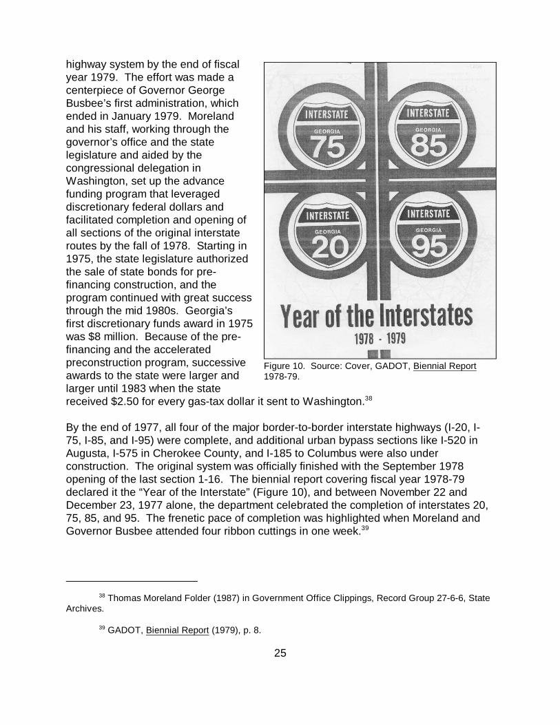
By the end of 1977, all four of the major border-to-border interstate highways (I-20, I-75, I-85, and I-95) were complete, and additional urban bypass sections like I-520 inAugusta, I-575 in Cherokee County, and I-185 to Columbus were also underconstruction. The original system was officially finished with the September 1978opening of the last section 1-16. The biennial report covering fiscal year 1978-79declared it the “Year of the Interstate” (Figure 10), and between November 22 andDecember 23, 1977 alone, the department celebrated the completion of interstates 20,75, 85, and 95. The frenetic pace of completion was highlighted when Moreland andGovernor Busbee attended four ribbon cuttings in one week. 39
Figure 10. Source: Cover, GADOT, Biennial Report1978-79.
Paul V. Liles, Jr., who started with the Department in their training program in 1970 and40
became state bridge engineer in 1988, remembers Moreland’s ability to instill his staff with great personal responsibility for production. “You felt like everything depended on you and that you did not want to bethe one that let the project down.” Although he is remembered by many as being a strong leader, Lilesstated that he would also be the first person to commend a job well done. (Personal communication toMary E. McCahon, April, 2006).
Award of interstate discretionary funds was predicated on the following criteria; spent all41
allocation, have plans in hand ready to let, and have 10% state matching funds in hand.
Liles, Sept. 2006.42
26
Without Moreland’s vision and leadership, it is not likely that the acceleratedcompletion of the interstates would have been accomplished. In addition to hisacknowledged ability to motivate his staff, he never lost focus of the big picture. In40
order to finish the interstates during Governor Busbee’s first administration, Morelandset up a letting schedule that was held to be inviolate. He directed a logicalprogression of staged designs and contract awards. For instance, bridges needed tohaul materials to a site were designed and let ahead of overpasses, which could waituntil the earthwork associated with grading and preparing the roadway bed was wellunderway. In this manner, like a general leading his troops, Moreland orchestrated anefficient and effective construction campaign that put the state’s interstate highwayprogram in the national spotlight.
To be considered for discretionary funds meant that the department had to use all of itsannual interstate federal allocation nine months into each federal fiscal year. This41
meant that the department’s engineers and specialists had to complete a year’s worthof work in nine months and then complete the plans for discretionary-funded work. Itwas a hectic pace. Moreland reasoned that he could leverage even more productionby using his staff to supervise work being done by consulting engineers with eachengineer supervising several projects rather than doing the actual design himself. 42
Freeing the Freeways
While the accelerated completion of the interstate system certainly was an outstandingaccomplishment for the department, Moreland’s and the state’s national reputation formodernizing its transportation systems was further burnished by the massive 1976-1988 campaign to reconstruct the metro Atlanta interstate system. The work wasdesperately needed as actual traffic volumes far exceeded design projections, andsome sections were approaching 30 years of age and the end of their design life. Despite incremental rehabilitation projects, most of the sections still had deficientgeometry and safety features, and the inadequacy of the downtown connectorcontinued to stymie traffic flow through the region. The success of the $1.4 billion“freeing the freeways [of congestion]” campaign, the largest urban interstatereconstruction program of its day, was, again, based on Moreland’s shrewd ability to
The Clean Air Act of 1990 and the Intermodal Surface Transportation Enhancement Act43
(ISTEA) of 1991 mandate that all transportation projects consider their impact on ambient air quality. The result has been that in areas of nonattainment, like Atlanta, additional highway lanes cannot beconstructed unless it can be demonstrated that emissions will not exceed the 1990 level. The result hasbeen that additional lanes cannot be added to interstate or any other classification of highways in areasof nonattainment, and this has severely affected urban areas that did not upgrade their urban interstatehighways before the provisions of the two acts were implemented in the mid 1990s.
Hayes E. Ross, Jr., “Evolution of Roadside Safety,” in Roadside Safety Issues, Transportation44
Research Circular, Transportation Research Board/National Research Council, 1994.
27
make use of shifts in federal priorities and policies and leverage millions of federaldollars to complete the project.
Pursuing the freeing the freeways campaign was a pragmatic acknowledgment thatreconstruction of existing expressways, not new construction, was the way to addressAtlanta’s severe traffic congestion problems. Environmental laws from the 1960s, likethe NHPA and NEPA and subsequent court decisions, meant that no moresuperhighways were going to be constructed inside the perimeter road. The departmentcorrectly reasoned that instead of fighting for new roads, they would expand the onesthey had – a decision that has served the state well as lane capacity in and aroundAtlanta was significantly expanded at a time when it was possible to do so. And43
starting about 1976, mass transit was included as part of that rebuilding effort.
The mid-1970s decision to pursue reconstruction was based, in part, on national shiftsin thinking about both design of interstate highways and what types of work should beallowed using interstate construction funds. Beginning about 1960, research wasproving that traffic fatalities could be significantly reduced by changing unyieldingroadsides to forgiving ones free of obstructions such as light poles, signs, blunt ends ofbridge railings, and confusing geometry. Mounting evidence that all manner of highwaygeometry and roadside appliances from culverts in medians to maintaining the roadwaysection across bridges made a dramatic difference in safety led to the 1966 HighwaySafety Act. The act placed the federal government and the newly established FHWA inthe leadership role to guide and finance highway safety activities for all types ofhighways, particularly the interstates. The American Association of State Highway andTransportation Officials (AASHTO) quickly followed with its influential 1967 HighwayDesign and Operational Practices Related to Highway Safety report that established the30'-wide clear zone. The clear zone was intended to provide vehicles leaving the roada safe recovery area free of obstructions that could cause injury or death. The44
recommendations in the report, from break-away poles to carrying shoulders throughaccess ramps and placement of signs, affected such dramatic reductions in fatalitiesthat a FHWA engineer working in Ohio in 1969 stated that old (pre-1967) designfeatures like guide rails and light poles were replaced with the new, safer ones on anyproject that was less than 95% complete, even if the roadside features were brand
Wright Aldridge, “A Lesson in Safety,” Internet On-line, <http://fhwa.dot.gov/interstates/45
memories.htm. [Oct. 13, 2006].
Ross (1994), p. 6.46
28
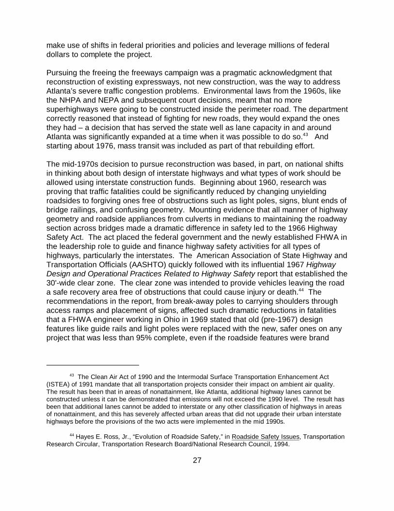
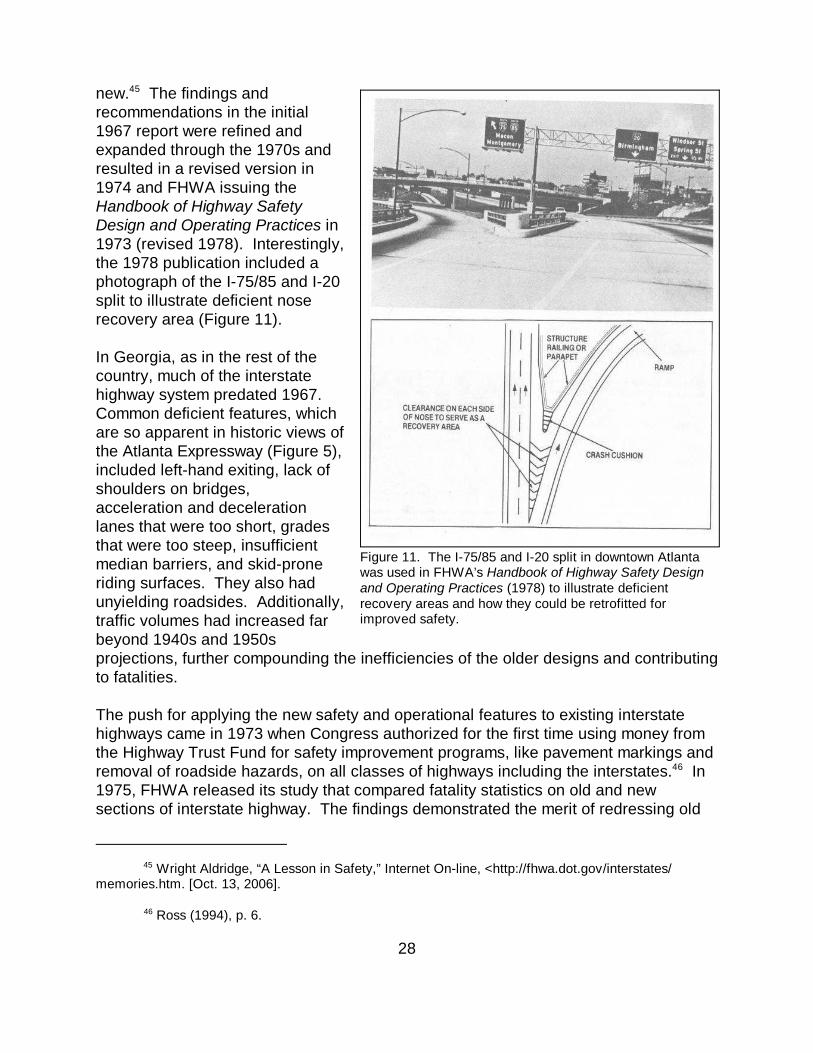
new. The findings and45
recommendations in the initial1967 report were refined andexpanded through the 1970s andresulted in a revised version in1974 and FHWA issuing theHandbook of Highway SafetyDesign and Operating Practices in1973 (revised 1978). Interestingly,the 1978 publication included aphotograph of the I-75/85 and I-20split to illustrate deficient noserecovery area (Figure 11).
In Georgia, as in the rest of thecountry, much of the interstatehighway system predated 1967. Common deficient features, whichare so apparent in historic views ofthe Atlanta Expressway (Figure 5),included left-hand exiting, lack ofshoulders on bridges, acceleration and decelerationlanes that were too short, gradesthat were too steep, insufficientmedian barriers, and skid-proneriding surfaces. They also hadunyielding roadsides. Additionally,traffic volumes had increased farbeyond 1940s and 1950sprojections, further compounding the inefficiencies of the older designs and contributingto fatalities.
The push for applying the new safety and operational features to existing interstatehighways came in 1973 when Congress authorized for the first time using money fromthe Highway Trust Fund for safety improvement programs, like pavement markings andremoval of roadside hazards, on all classes of highways including the interstates. In46
1975, FHWA released its study that compared fatality statistics on old and newsections of interstate highway. The findings demonstrated the merit of redressing old
Figure 11. The I-75/85 and I-20 split in downtown Atlantawas used in FHWA’s Handbook of Highway Safety Designand Operating Practices (1978) to illustrate deficientrecovery areas and how they could be retrofitted forimproved safety.
U.S. General Accounting Office, “Report to the Congress by the Comptroller General of the47
United States, Costs and Problems of Completing the Interstate Highway System,” (Sept. 4, 1975), p. 14.
29
design standards. Using the watershed year of 1967 as the break, the study provedthat interstates designed after 1966 were much safer in both urban and rural sections. The report concluded that upgrading pre-1967 sections of interstate to post-1967standards would contribute to “overall safety of the system.” At that time, “oldersections” comprised 77% of the total system miles nationwide. In response to the47
cumulative safety data and the fact that some of the oldest sections of interstatehighway were approaching the end of their design life, the Federal-Aid Highway Act of1976 expanded the definition of what work could be done using interstate constructionfunds to include resurfacing, rehabilitation and restoration (known as the 3 Rs inhighway parlance) for sections that were greater than five years old.
The 1976 expansion of allowable work marked a sea change in the evolution of theinterstate highway system as it now permitted adding lanes, improving geometry,building new interchanges, or significantly improving existing ones – all of theenhanced maintenance items needed to bring the entire system, regardless of date oforiginal construction, into compliance with modern design and safety feature standards. The Surface Transportation Assistance Act (STAA) of 1978 further strengthened thepolicy shift by earmarking interstate construction funding for 3R work, and this at a timewhen many states had not even completed all of their original mileage.
The timing of the policy change could not have been better for Georgia. It meant thatrather than marking the end of its interstate construction early in 1978 with the border-to-border completion of the original routes, Georgia could now apply the sameimmensely successful approach of pre-financing and accelerated preconstructionactivities to rebuilding the metro Atlanta interstates using the 90/10 funding formula. The allowable 3R activities would make it possible to provide a higher level of serviceby increasing the number of lanes and improving interchanges, as well as upgrading ahost of roadside and operational features.
To appease varied interests, the Federal-Aid Highway Act of 1981 clarified the distinction between the two types of allowable interstate construction by defining workto complete the gaps in the original system as interstate construction (IC) and addingreconstruction (the fourth R) to allowable work to bring old, existing sections up tocurrent design and safety standards. A funding formula for 4R work was establishedusing the 90/10 ratio, and the Surface Transportation Assistance Act (STAA) of 1982established a mechanism for dispersing any lapsed I-4R funds to states that couldobligate them. The dispersal criteria were the same as for earlier lapsed interstate
Richard F. Weingroff, “Origins of the Interstate Maintenance Program,” Internet On-line,48
FHWA, Highway History <http://www.fhwa.dot.gov/infrastructure/intmaint.cfm>, [Oct. 18, 2006].
U.S. Secretary of Transportation, “A Revised Estimate of the Cost of Completing the National49
System of Interstate and Defense Highways (March 1983), pp. 11-13.
Thomas Moreland Folder (1987) in Government Office Clippings, Record Group 27-6-6, State50
Archives.
30
discretionary funds – having plans in hand and being able to quickly let contracts forthat work. 48
Thomas Moreland and the Georgia delegation played a significant part in the draftingand passage of the federal highway legislation that was favorable to Georgia’sreconstruction program. With the same deftness used to secure funds for completingthe original routes, the department set out again to get discretionary funds. Due toinflation and dramatic drops in gas-tax revenue in the late 1970s and early 1980s,some states were not able to obligate their I-4R allocations, which meant that fairlylarge sums of turned back money was available for states, like Georgia, that could. While Georgia was not the only state making use of discretionary I-4R fund, by the endof 1981 it was far and away the leader in pre-financing, with the federal governmentowing it $476,525,000 – more than three times that owed Florida, the next closeststate. So successful was Georgia’s approach to financing the hugely expensive49
freeway reconstruction program that by 1983 Georgia had moved from a donor state toa recipient state receiving $2.50 returned for every Georgia dollar sent toWashington. 50
Moreland directed his staff to complete the metro Atlanta reconstruction with minimumdisruption to the traveling public. Work to increase lanes from six to eight on I-20, I-75,I-85, and I-285 and ten lanes on the downtown connector involved 126 total miles andwas phased over 13 years between 1976 and 1988. The improvement campaign alsoincluded elimination of sharp curves and grades, left-hand exists, excessiveinterchanges, and short acceleration/deceleration lanes. About 30 miles of HOV laneswere also provided on the northeast leg of I-85 as part of the reconstruction as werepark-and-ride facilities. So as to offer a bypass around construction through the centerof the city, the perimeter road (I-285) was completed first. The radiating expresswayswere then upgraded, and the last phase was reconstruction of the depressed sectionsthrough downtown Atlanta. By June 1983, some $252 million in discretionary fundshad been used to complete most of the highways save for some major interchangesand the downtown section (Figure 12).
The eight miles of the downtown section, which includes the 4.4-mile long downtownconnector, was the most complicated section of the entire reconstruction. Work wasstarted on it in 1984, and it included redesigning the massive interchange between I-20
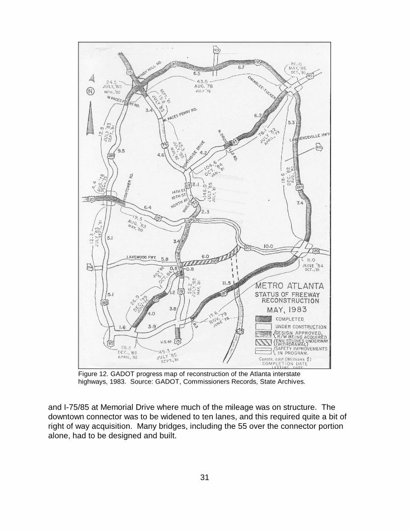
31
and I-75/85 at Memorial Drive where much of the mileage was on structure. Thedowntown connector was to be widened to ten lanes, and this required quite a bit ofright of way acquisition. Many bridges, including the 55 over the connector portionalone, had to be designed and built.
Figure 12. GADOT progress map of reconstruction of the Atlanta interstatehighways, 1983. Source: GADOT, Commissioners Records, State Archives.
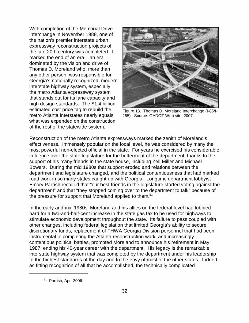
Parrish, Apr. 2006.51
32
With completion of the Memorial Driveinterchange in November 1988, one ofthe nation’s premier interstate urbanexpressway reconstruction projects ofthe late 20th century was completed. Itmarked the end of an era – an eradominated by the vision and drive ofThomas D. Moreland who, more thanany other person, was responsible forGeorgia’s nationally recognized, moderninterstate highway system, especiallythe metro Atlanta expressway systemthat stands out for its lane capacity andhigh design standards. The $1.4 billionestimated cost price tag to rebuild themetro Atlanta interstates nearly equalswhat was expended on the constructionof the rest of the statewide system.
Reconstruction of the metro Atlanta expressways marked the zenith of Moreland’seffectiveness. Immensely popular on the local level, he was considered by many themost powerful non-elected official in the state. For years he exercised his considerableinfluence over the state legislature for the betterment of the department, thanks to thesupport of his many friends in the state house, including Zell Miller and MichaelBowers. During the mid 1980s that support eroded and relations between thedepartment and legislature changed, and the political contentiousness that had markedroad work in so many states caught up with Georgia. Longtime department lobbyistEmory Parrish recalled that “our best friends in the legislature started voting against thedepartment” and that “they stopped coming over to the department to talk” because ofthe pressure for support that Moreland applied to them.51
In the early and mid 1980s, Moreland and his allies on the federal level had lobbiedhard for a two-and-half-cent increase in the state gas tax to be used for highways tostimulate economic development throughout the state. Its failure to pass coupled withother changes, including federal legislation that limited Georgia’s ability to securediscretionary funds, replacement of FHWA Georgia Division personnel that had beeninstrumental in completing the Atlanta reconstruction work, and increasinglycontentious political battles, prompted Moreland to announce his retirement in May1987, ending his 40-year career with the department. His legacy is the remarkableinterstate highway system that was completed by the department under his leadershipto the highest standards of the day and to the envy of most of the other states. Indeed,as fitting recognition of all that he accomplished, the technically complicated
Figure 13. Thomas D. Moreland Interchange (I-85/I-285). Source: GADOT Web site, 2007.

33
interchange between I-285 and I-85 with its graceful sweeps of prestressed concretebox beam bridges was named the Thomas D. Moreland Interchange in his honor(Figure 13). The interchange, which encompasses some 311 acres, was built between1982 and 1987 and cost $86 million. It and similarly designed interchanges in themetro region are the most dramatic elements of the building campaign that setsGeorgia apart during the last half of the era of interstate highway construction.