historic auto tours - pulaski · pdf fileroute 66 frisco railroad fort leonard wood discover...
TRANSCRIPT

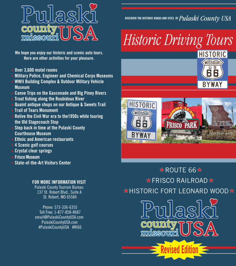
ROUTE 66
FRISCO RAILROAD
HISTORIC FORT LEONARD WOOD
DISCOVER THE HISTORIC ROADS AND SITES OF MISSOURI’S Pulaski County USA
Scan to load our PulaskiCountyUSA website
Scan to load our Audio Tour
Historic Driving Tours
Historic Auto Tours OF MISSOURI’S PULASKI COUNTY USA Historic Route 66
WELCOME!We hope you enjoy our natural and historical sites. Take some time along your way to enjoy the hospitality of our shops and restaurants.
Now, choose a driver and a navigator to read as you go.
We hope you enjoy the tours. Enhance your tour by downloading the interactive online maps from PulaskiCountyUSA.com Digital Downloads page.
TOUR 1: Historic Route 66 Page 1-8
33 milesApproximate Drive Time: 1.5 Hours Mileage in Black follows Route 66 East to WestMileage in Green follows Route 66 West to EastEnhance your tour by downloading the audio tourfrom PulaskiCountyUSA.com (East to West only)
TOUR 2: Frisco Railroad Page 9-10
37 milesApproximate Drive Time: 1.5 Hours Extended Route 45 milesApproximate Drive Time: 1.75 Hours
TOUR 3: Fort Leonard Wood Page 11-12
Mini Route: 9 milesApproximate Drive Time: .5 Hours
Extended Route: 20 milesApproximate Drive Time: 1.25 Hours
Auto Tour Map & History Page 13-14
The numbers beside each entry refer to the mileage from the start point of each tour. At the starting point set your trip meter and begin your adventure!
Enhance your tour with our phone app and audio tour
The path which picks its way westward through Pulaski County, Missouri is as timeless as the Ozark Mountains that it winds its way through. The trail was first used by migrating animals and later by the Osage and other Native American tribes. Before Missouri gained statehood in 1821 adventurers followed the trail in search of land, prosperity, and new beginnings. The Southwestern Stage Company bumped along this beaten path through the wilderness. By 1911, vacationers, some in automobiles, seeking recreation followed the old trail to Possum Lodge near Devils Elbow on the Big Piney River. As motorized carriages became more popular in the early 1920’s support for good roads led to improvements to the trail and a new name, Highway 14, later designated as Route 66 in 1926. Two of Pulaski County’s three original bridges, the 1923 Devils Elbow Steel Bridge and the 1923 Roubidoux Bridge in Waynesville predate the Route 66 designation. Improved highways led to the creation of even more roadside businesses that catered to travelers. Craftsmensold their woven baskets as souvenirs. Hungry motorists dined on hamburgers, fried chicken, and homemade pies. Filling stations pedaled their branded fuel to drivers. Auto courts and roadside hotels provided overnight lodging. Competition for the traveler’s dollar could be fierce. Convenience, and frequently, a gimmick, could lead to the success and longevity of a business. Roadside businesses established in 1940 thrived during construction of Fort Leonard Wood. However, those same businesses scrambled to survive when increased traffic prompted Route 66 improvements and realignments. The nation’s desire for faster, safer travel led to the creation of the Interstate system and to the ultimate demise of Route 66. By the end of January 1980 all Route 66 signage had been removed in Pulaski County. Route 66 was officially deleted as a federal highway June 27, 1985. However, the legendary road did not fade into obscurity. Travelers and Route 66 “roadies” began to seek out the former route to document roadside businesses, bridges, alignments, and architecture. Renewed interest led to Missouri designating her 307 miles of Route 66 as a historic district July 10, 1990. Governor John Ashcroft signed the iconic bill in front of the then new Courthouse at Waynesville, Pulaski County. Missouri was the first state to award the highway historic status. This designation cemented Waynesville’s role as “The Birthplace of the Byway.” Today travelers from the United States and from around the globe trek to experience the former Mother Road.
The following turn by turn directions were adapted and highly condensed from “Route 66 in Pulaski County, Missouri (a local history),” authored by Terry Primas, published 2017. Mr. Primas has produced interpretive tour materials about Route 66 in Pulaski County in a variety of formats and serves as a step-on guide for Route 66 motor coach tour groups for Pulaski County Tourism Bureau. You may purchase his comprehensive book at the Visitors Center in Saint Robert.
0.0 mi. (27.6 mi.) At Interstate 44 Exit 169 proceed to County Highway J and County Highway Z intersection. Turn right onto County Highway Z. Just before the 35 mile-per-hour speed limit sign reset your trip odometer to 0.0. This is a stretch of the “Mother Road” that was paved in 1943 when Route 66 became a four-lane highway in Pulaski County. Jack D. Rittenhouse called this section “an engineering triumph and truly a joy to the traveler” in his 1946 book A Guide Book to Highway 66.
(1.6 mi.) (26 mi.) The remodeled private residence across the divided highway (look left), is the original STERLING HILLBILLY STORE, famous for their 19 cent burgers. The water pump, now painted red, can be seen in vintage postcards of the store.
1.9 mi. (25.7 mi.) Look to the right through the trees to see HOOKER
CHURCH & GRAVEYARD or turn off on Trophy Road. It dates to the early 1900’s. Hooker had a high school located across Hwy. 14 (the gravel road) in front of the church. The St. Louis Post-Dispatch declared it the smallest high school in Missouri in 1929.
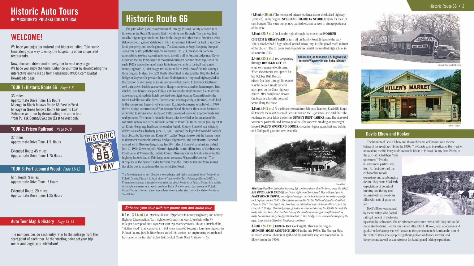
2.4 mi. (25.2 mi.) You are passing through HOOKER CUT, an engineering marvel of its time. When the contract was opened for bid October 1941 the cut, ninety-feet deep through limestone, was the deepest single cut ever attempted on the State highway system. After completion Hooker Cut became a favorite postcard scene along the route.
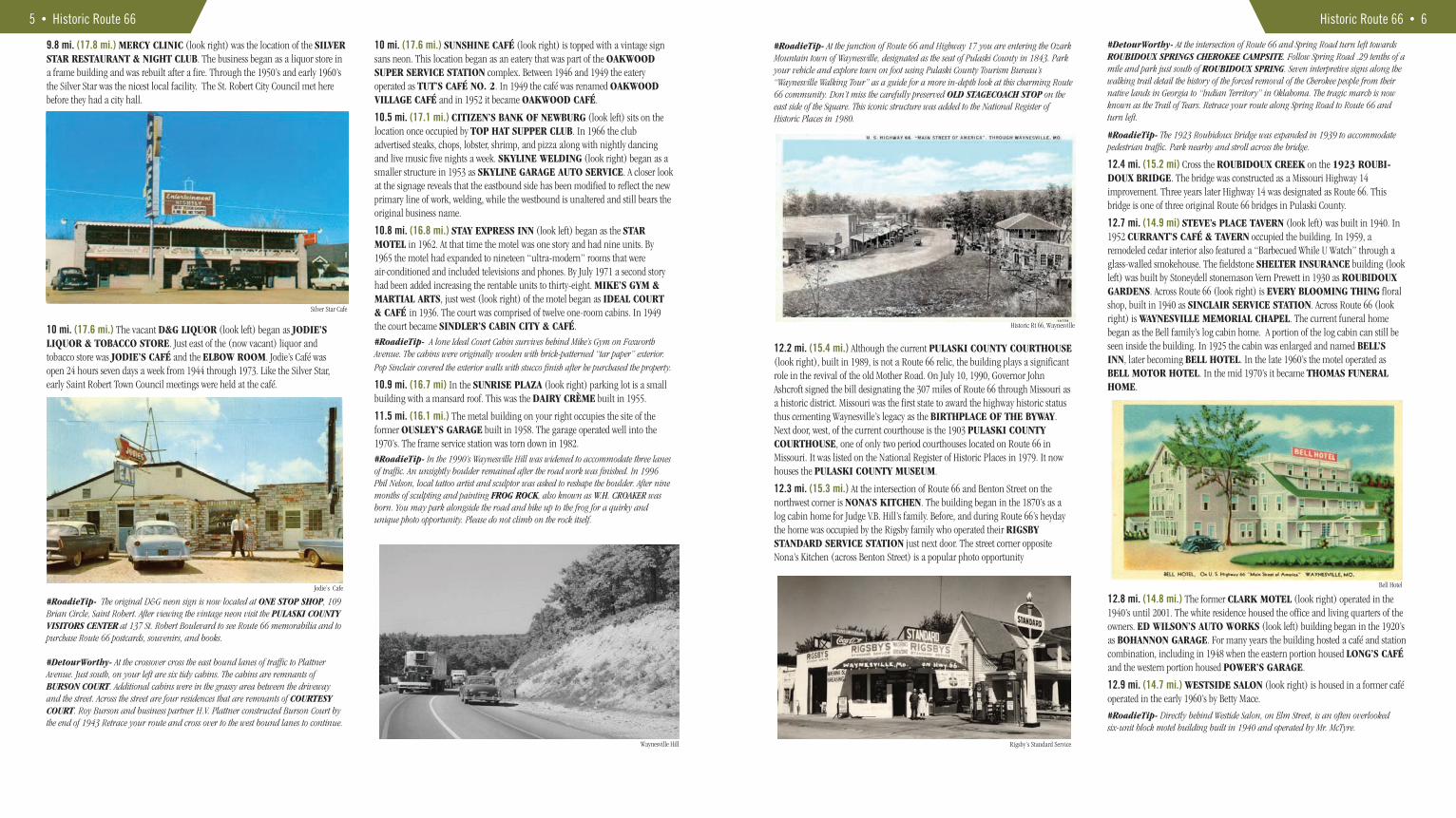
3.0 mi. (24.6 mi.) At the first crossroads turn left onto Teardrop Road/Old Route 66 towards the resort haven of Devils Elbow on the 1930’s two-lane “Old 66.” The residence on your left is the former SUNSET REST CABINS store. The store sold souvenirs, postcards, and Texaco gasoline. The concrete building on your right housed DALE’S SPORTING GOODS. Groceries, liquor, guns, bait and tackle, and Phillips 66 gasoline were available.
#DetourWorthy- Instead of turning left continue down double lanes, cross the 1942 BIG PINEY ARCH BRIDGE and turn right onto Tank Road. This will lead you to PINEY BEACH CABINS, an original cottage court which features the unique giraffe rock popular in the 1940’s. The cabins were added to the National Register of Historic Places in 2017. The beach also provides an interesting view of the unaltered 1942 Big Piney Arch Bridge. This bridge style, popular in Missouri during the 1920’s through the early 40’s, has been described as “one of the great engineering accomplishments of early twentieth century bridge construction.” This bridge is an excellent example of the
style. Loop back to Teardrop Road and continue.
3.3 mi. (24.3 mi.) ELBOW INN (look right). This was the original MUNGER-MOSS SANDWICH SHOP in the late 1930’s. The Munger-Moss relocated west to Lebanon in 1946 and the sandwich shop was reopened as the Elbow Inn in the 1960’s.
Devils Elbow and Hooker
Historic Route 66 • 2
Sunset Rest
Munger-Moss Sandwich Shop
Miller’s Market
Hooker Cut, on four-lane U.S. Highway 66,between Waynesville and Rolla, Missouri
The hamlets of Devil’s Elbow and Hooker became well known with the rise bridge of the sporting clubs in the 1890s. The Ozarks and, in particular, the riverine areas along the Big Piney and Gasconade Rivers in Pulaski County (and Phelps to the east) attracted these “true sportsmen.” Wealthy businessmen, particularly from St. Louis, formed the clubs for backwoods excursions and as a bragging forum. They came filled with expectations of bountiful hunting and fishing and returned with railroad cars filled with tons of game on ice. Devil’s Elbow was named by the tie rafters who floated railroad ties cut in the forests upstream by tie hackers. The tie rafts were sometimes over a mile long and could not make this bend. Hooker was named after John L. Hooker, local woodsmen and guide. Hooker’s camp was well-known to the sportsmen in St. Louis at the turn of the century. It became a popular gathering place for dances, revivals, and honeymoons, as well as a rendezvous for hunting and fishing expeditions.

#RoadieTip- Park near the Elbow Inn and walk across the 1923 Steel Truss Bridge. A 1925 edition of the St. Louis Post-Dispatch reported “From the high, modern bridge across the stream turtles may be seen on the bed of the clear water.” Travelers still report seeing turtles and schools of fish in the river bottom on the bluff side of the structure.
3.4 mi. (24.2 mi.) Cross the 1923 STEEL TRUSS BRIDGE and the BIG PINEY RIVER. The bridge was dedicated July 4, 1924, before Highway 14 was designated as Route 66. While crossing the bridge look left to see dramatic limestone bluffs. They were marketed as “HIAWATHA BLUFFS” during the 1930’s when Devils Elbow was being developed as a summer home community. They were once listed by the State Planning Commission as one of Missouri’s “beauty spots.” They continue to be a favorite with photographers and artists.
3.6 mi. (24 mi.) This is the community of DEVILS ELBOW. In 2017 eight properties comprising the Devils Elbow Historic District were added to the National Register of Historic Places. The block building on your left occupies the footprint of the CEDAR LODGE/DEVILS ELBOW CAFE. A postcard picture describes the café as “where the main street of America (US Hwy. 66) winds its way through one of the most scenic areas in the Ozark region.” Look left at this corner to see SHELDEN’S MARKET & POST OFFICE. It was built in 1954 as MILLER’S MARKET. The residence on the opposite corner of this intersection began as HIAWATHA LODGE, a log building built circa 1917 offering roadside lodging/eating and recreation opportunities on the river.
3.6 mi. (24 mi.) As you start to climb the hill notice the native stone house on your left. It occupies the original footprint of GRAHAM’S RESORT & CAMP which later became BIG PINEY LODGE. This property offered up to fourteen cabins for rent. Some of the cabins were rented into the 1980’s.
3.9 mi. (23.7 mi.) You are at a landmark once known as DEVILS ELBOW CUT. In 1923, as part of a Highway 14 improvement the bluff to your right was blasted with explosives costing $1,500 to widen the driving surface. The masonry wall on your left was also part of the improvement. The wall replaced a post and cable fence which had previously replaced a wooden fence. You will also notice the road surface changes to 1930’s concrete pavement near the start of the wall. This change marks the projected water level if the proposed (1929) Gasconade River Power Company dam had been constructed at Arlington, Phelps County. Because of the potential dam “a considerable stretch of US-66 between Waynesville and Arlington has been left unpaved for years.”
4.0 mi. (23.6 mi.) The SCENIC OVERLOOK features a view of the Big Piney River valley below. The U.S. ARMY TRESTLE RAILROAD BRIDGE was constructed as a spur from the Frisco Railroad’s Bundy Junction to Fort Leonard Wood. The project, an engineering triumph, began early December 1940 and was completed early May 1941. The chief engineer stated that the obstacles that were overcame to complete the railroad spur were comparable to building in the heart of the Rockies.
4.8 mi. (22.8 mi) You are in the GRANDVIEW community. The native stone building on your right is the former E-Z INN CABINS & CAFÉ. In 1947 it was renamed as OAK PARK. Next to the lodge stood four native stone cabins which were razed in 2010. JUDY’S PLACE on your left was operating as the FALCON CLUB in the late 1970’s.
4.9 mi. (22.7 mi.) Left onto the original “new” Route 66 pavement. This is some of the best 1943 curbed pavement in the state. Across the intersection is the former DEVILS ELBOW MOTEL. Built in 1950, the motel had eleven units and the five-room dwelling doubled as the office.
#DetourWorthy- FOR THE ADVENTUROUS DURING DRY WEATHER: From the “new” divided Route 66 pavement make the first left onto Teak Lane. Follow Teak Lane south. Slightly before the railroad tracks the road will curve west and continues very near both the U.S. Army Railroad Spur and the Big Piney River. .9 mi. on your right is BLUE SPRING/SHANGHAI SPRING. To your left you will see where the spring discharges into the river. Both sides of the road are private property. Shanghai Spring is one of several natural springs that feed the Big Piney River. Continue following Teak Lane. Just after crossing the railroad tracks and the concrete ford turn right at the yellow canoe onto Tulsa Road. Tulsa Road intersects with Highway Z, which is Old Route 66. Turn right to backtrack to the Highway Z and Highway 28 junction or turn left and continue to Highway Z and Missouri Avenue junction.
5.9 mi. (21.7 mi.) Highway Z and Highway 28 junction. BEST WESTERN on your left opened in 1974 as MONTIS MOTOR INN. COUNTRY CAFÉ, west of the hotel was originally KING’S PANCAKE RANCH. During construction a Native American mass burial was discovered. Artifacts from the discovery were shipped to California. Continue forward.
3 • Historic Route 66
Devils Elbow Motel
#DetourWorthy- At the Highway Z and Highway 28 junction turn right to cross over the Interstate 44 overpass and follow Highway 28 north one-half mile. At the wye intersection of Highway 28 and Holly Drive park in front of the mounded piles of dirt. A scramble over these piles will deliver you onto Pulaski County’s “ghost section” of Route 66. This short segment of abandoned two-lane 1930’s Route 66 was cut off during the construction of “new” Route 66 during the 1940’s. Known as MORGAN HEIGHTS the community was served by a tourist hotel, cabins, café, and filling station.
Return to the Highway Z and Highway 28 intersection and turn right to continue.
6.2 mi. (21.4 mi.) SUNSET VILLAGE OF THE OZARKS, on your right, began in 1971 as the posh SHERATON SEVEN PALMS motel and resort.
6.5 mi. (21.1 mi.) On your left is the site of the former MARK TWAIN MOTEL & RESTAURANT built in 1957. The URANUS entertainment complex sits on the footprint.
8.8 mi. (18.8) The junction of Highway Z (formerly Route 66) and Missouri Avenue (formerly Missouri 17) was known as THE WYE during the construction boom of Fort Leonard Wood that began January 1941. Former businesses at this junction have included WYE PARK STORE, SCOTT’S GARAGE, DIME-A-DANCE CLUB, RAMADA INN (LIBERTY LODGE is a remodeled section with 66 rooms) and TWI-LITE MOTEL & CAFÉ. BUDGET INN, on the southeast corner, is the former COLONIAL MOTOR INN built in 1971. Continue forward.
#DetourWorthy- At the Highway Z and Missouri Avenue junction turn left and follow Missouri Avenue two miles south to the Main Gate of FORT LEONARD WOOD. The armed forces training base covers 60,000 acres and includes three excellent indoor museums and an open-air museum comprised of World War II era military buildings. Stop at the MAIN GATE VISITORS CENTER to obtain installation access. Return via Missouri Avenue to Eastlawn Avenue and turn right. Follow Eastlawn Avenue .24 tenths of a mile to the SAINT ROBERT MUNICIPAL CENTER on your right. Inside you will find the CITY OF SAINT ROBERT MUSEUM which documents the construction, history, and growth of the military boomtown. Return to Missouri Avenue driving north until the Highway Z and Missouri Avenue junction. Turn left to resume your Route 66
tour on divided four-lane.
9.1 mi. (18.5 mi.) GEORGE M. REED ROADSIDE PARK on your left is one of only two remaining Route 66 roadside parks in Missouri. The park was dedicated June 12, 1955. Namesake George Marcellus Reed was the County Highway Engineer responsible for the survey along which State Highway 14 crossed the Big Piney River at Devils Elbow and ultimately became U.S. 66. The park is still a favorite picnic spot for both locals and travelers and is the future home of the ROUTE 66 NEON PARK. (www.Route66Preservation.org)
9.5 mi. (18.1 mi.) The RANCH MOTEL (look left) was built in 1950 as a white frame structure. It has since been “rocked.” The RELAX INN (look left) was opened in 1966 as DEVILLE MOTOR INN. The motel offered 39 “ultra-mod-ern” units, each with a television. Another amenity on the property was the DEVILLE RESTAURANT, now INVESTMENT REALTY.
#DetourWorthy- At the crossover cross the east bound lanes of traffic. Ahead of you is the former OAKS COURT TEXACO STATION/DEVILLE TEXACO. A southwest portion of the roof over the station office still faintly bears the name “Oaks Court.” Ahead of you, between the service station and BASSETT INSURANCE is the laundry room of the former Oaks Court. Before 1946 Oaks Court operated as C.A. TRAILER CAMP. Retrace your route and cross over to the west bound lanes to continue.
Historic Route 66 • 4
Morgan Heights
Ranch Motel
Historic Rt 66 & Missouri Ave. (Fort Wood Spur)
Mark Twain Motel & Restaurant
9.8 mi. (17.8 mi.) MERCY CLINIC (look right) was the location of the SILVER STAR RESTAURANT & NIGHT CLUB. The business began as a liquor store in a frame building and was rebuilt after a fire. Through the 1950’s and early 1960’s the Silver Star was the nicest local facility. The St. Robert City Council met here before they had a city hall.
10 mi. (17.6 mi.) The vacant D&G LIQUOR (look left) began as JODIE’S LIQUOR & TOBACCO STORE. Just east of the (now vacant) liquor and tobacco store was JODIE’S CAFÉ and the ELBOW ROOM. Jodie’s Café was open 24 hours seven days a week from 1944 through 1973. Like the Silver Star, early Saint Robert Town Council meetings were held at the café.
#RoadieTip- The original D&G neon sign is now located at ONE STOP SHOP, 109 Brian Circle, Saint Robert. After viewing the vintage neon visit the PULASKI COUNTY VISITORS CENTER at 137 St. Robert Boulevard to see Route 66 memorabilia and to purchase Route 66 postcards, souvenirs, and books.
#DetourWorthy- At the crossover cross the east bound lanes of traffic to Plattner Avenue. Just south, on your left are six tidy cabins. The cabins are remnants of BURSON COURT. Additional cabins were in the grassy area between the driveway and the street. Across the street are four residences that are remnants of COURTESY COURT. Roy Burson and business partner H.V. Plattner constructed Burson Court by the end of 1943 Retrace your route and cross over to the west bound lanes to continue.
5 • Historic Route 66
Silver Star Cafe
Jodie’s Cafe
Waynesville Hill
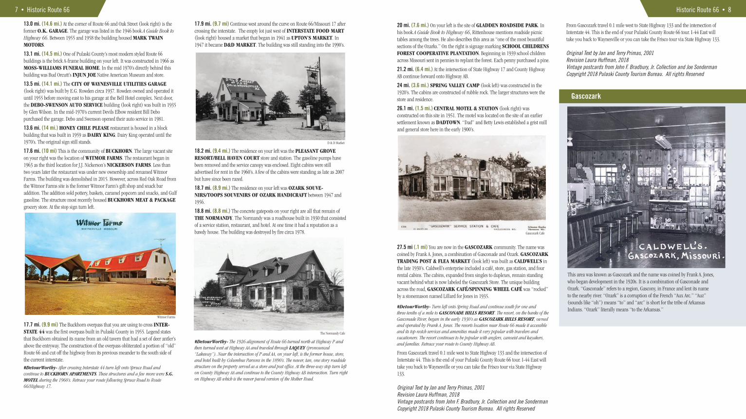
10 mi. (17.6 mi.) SUNSHINE CAFÉ (look right) is topped with a vintage sign sans neon. This location began as an eatery that was part of the OAKWOOD SUPER SERVICE STATION complex. Between 1946 and 1949 the eatery operated as TUT’S CAFÉ NO. 2. In 1949 the café was renamed OAKWOOD VILLAGE CAFÉ and in 1952 it became OAKWOOD CAFÉ.
10.5 mi. (17.1 mi.) CITIZEN’S BANK OF NEWBURG (look left) sits on the location once occupied by TOP HAT SUPPER CLUB. In 1966 the club advertised steaks, chops, lobster, shrimp, and pizza along with nightly dancing and live music five nights a week. SKYLINE WELDING (look right) began as a smaller structure in 1953 as SKYLINE GARAGE AUTO SERVICE. A closer look at the signage reveals that the eastbound side has been modified to reflect the new primary line of work, welding, while the westbound is unaltered and still bears the original business name.
10.8 mi. (16.8 mi.) STAY EXPRESS INN (look left) began as the STAR MOTEL in 1962. At that time the motel was one story and had nine units. By 1965 the motel had expanded to nineteen “ultra-modern” rooms that were air-conditioned and included televisions and phones. By July 1971 a second story had been added increasing the rentable units to thirty-eight. MIKE’S GYM & MARTIAL ARTS, just west (look right) of the motel began as IDEAL COURT & CAFÉ in 1936. The court was comprised of twelve one-room cabins. In 1949 the court became SINDLER’S CABIN CITY & CAFÉ. #RoadieTip- A lone Ideal Court Cabin survives behind Mike’s Gym on Foxworth Avenue. The cabins were originally wooden with brick-patterned “tar paper” exterior.
Pop Sinclair covered the exterior walls with stucco finish after he purchased the property.
10.9 mi. (16.7 mi) In the SUNRISE PLAZA (look right) parking lot is a small building with a mansard roof. This was the DAIRY CRÈME built in 1955.
11.5 mi. (16.1 mi.) The metal building on your right occupies the site of the former OUSLEY’S GARAGE built in 1958. The garage operated well into the 1970’s. The frame service station was torn down in 1982.#RoadieTip- In the 1990’s Waynesville Hill was widened to accommodate three lanes of traffic. An unsightly boulder remained after the road work was finished. In 1996 Phil Nelson, local tattoo artist and sculptor was asked to reshape the boulder. After nine months of sculpting and painting FROG ROCK, also known as W.H. CROAKER was born. You may park alongside the road and hike up to the frog for a quirky and unique photo opportunity. Please do not climb on the rock itself.
#RoadieTip- At the junction of Route 66 and Highway 17 you are entering the Ozark Mountain town of Waynesville, designated as the seat of Pulaski County in 1843. Park your vehicle and explore town on foot using Pulaski County Tourism Bureau’s “Waynesville Walking Tour” as a guide for a more in-depth look at this charming Route 66 community. Don’t miss the carefully preserved OLD STAGECOACH STOP on the east side of the Square. This iconic structure was added to the National Register of Historic Places in 1980.
12.2 mi. (15.4 mi.) Although the current PULASKI COUNTY COURTHOUSE (look right), built in 1989, is not a Route 66 relic, the building plays a significant role in the revival of the old Mother Road. On July 10, 1990, Governor John Ashcroft signed the bill designating the 307 miles of Route 66 through Missouri as a historic district. Missouri was the first state to award the highway historic status thus cementing Waynesville’s legacy as the BIRTHPLACE OF THE BYWAY. Next door, west, of the current courthouse is the 1903 PULASKI COUNTY COURTHOUSE, one of only two period courthouses located on Route 66 in Missouri. It was listed on the National Register of Historic Places in 1979. It now houses the PULASKI COUNTY MUSEUM.
12.3 mi. (15.3 mi.) At the intersection of Route 66 and Benton Street on the northwest corner is NONA’S KITCHEN. The building began in the 1870’s as a log cabin home for Judge V.B. Hill’s family. Before, and during Route 66’s heyday the home was occupied by the Rigsby family who operated their RIGSBY STANDARD SERVICE STATION just next door. The street corner opposite Nona’s Kitchen (across Benton Street) is a popular photo opportunity
Historic Route 66 • 6
#DetourWorthy- At the intersection of Route 66 and Spring Road turn left towards ROUBIDOUX SPRINGS CHEROKEE CAMPSITE. Follow Spring Road .29 tenths of a mile and park just south of ROUBIDOUX SPRING. Seven interpretive signs along the walking trail detail the history of the forced removal of the Cherokee people from their native lands in Georgia to “Indian Territory” in Oklahoma. The tragic march is now known as the Trail of Tears. Retrace your route along Spring Road to Route 66 and turn left.
#RoadieTip- The 1923 Roubidoux Bridge was expanded in 1939 to accommodate pedestrian traffic. Park nearby and stroll across the bridge.
12.4 mi. (15.2 mi) Cross the ROUBIDOUX CREEK on the 1923 ROUBI-DOUX BRIDGE. The bridge was constructed as a Missouri Highway 14 improvement. Three years later Highway 14 was designated as Route 66. This bridge is one of three original Route 66 bridges in Pulaski County.
12.7 mi. (14.9 mi) STEVE’s PLACE TAVERN (look left) was built in 1940. In 1952 CURRANT’S CAFÉ & TAVERN occupied the building. In 1959, a remodeled cedar interior also featured a “Barbecued While U Watch” through a glass-walled smokehouse. The fieldstone SHELTER INSURANCE building (look left) was built by Stoneydell stonemason Vern Prewett in 1930 as ROUBIDOUX GARDENS. Across Route 66 (look right) is EVERY BLOOMING THING floral shop, built in 1940 as SINCLAIR SERVICE STATION. Across Route 66 (look right) is WAYNESVILLE MEMORIAL CHAPEL. The current funeral home began as the Bell family’s log cabin home. A portion of the log cabin can still be seen inside the building. In 1925 the cabin was enlarged and named BELL’S INN, later becoming BELL HOTEL. In the late 1960’s the motel operated as BELL MOTOR HOTEL. In the mid 1970’s it became THOMAS FUNERAL HOME.
12.8 mi. (14.8 mi.) The former CLARK MOTEL (look right) operated in the 1940’s until 2001. The white residence housed the office and living quarters of the owners. ED WILSON’S AUTO WORKS (look left) building began in the 1920’s as BOHANNON GARAGE. For many years the building hosted a café and station combination, including in 1948 when the eastern portion housed LONG’S CAFÉ and the western portion housed POWER’S GARAGE.
12.9 mi. (14.7 mi.) WESTSIDE SALON (look right) is housed in a former café operated in the early 1960’s by Betty Mace.
#RoadieTip- Directly behind Westide Salon, on Elm Street, is an often overlooked six-unit block motel building built in 1940 and operated by Mr. McTyre.
Historic Rt 66, Waynesville
Bell Hotel
Rigsby’s Standard Service
13.0 mi. (14.6 mi.) At the corner of Route 66 and Oak Street (look right) is the former O.K. GARAGE. The garage was listed in the 1946 book A Guide Book to Highway 66. Between 1955 and 1958 the building housed MARK TWAIN MOTORS.
13.1 mi. (14.5 mi.) One of Pulaski County’s most modern styled Route 66 buildings is the brick A-frame building on your left. It was constructed in 1966 as MOSS-WILLIAMS FUNERAL HOME. In the mid 1970’s directly behind this building was Bud Orcutt’s INJUN JOE Native American Museum and store.
13.5 mi. (14.1 mi.) The CITY OF WAYNESVILLE UTILITIES GARAGE (look right) was built by E.G. Rowden circa 1937. Rowden owned and operated it until 1955 before moving east to his garage at the Bell Hotel complex. Next door, the DEBO-SWENSON AUTO SERVICE building (look right) was built in 1935 by Glen Wilson. In the mid-1970’s current Devils Elbow resident Bill Debo purchased the garage. Debo and Swenson opened their auto service in 1981.
13.6 mi. (14 mi.) HONEY CHILE PLEASE restaurant is housed in a block building that was built in 1959 as DAIRY KING. Dairy King operated until the 1970’s. The original sign still stands.
17.6 mi. (10 mi) This is the community of BUCKHORN. The large vacant site on your right was the location of WITMOR FARMS. The restaurant began in 1963 as the third location for J.J. Nickerson’s NICKERSON FARMS. Less than two years later the restaurant was under new ownership and renamed Witmor Farms. The building was demolished in 2015. However, across Red Oak Road from the Witmor Farms site is the former Witmor Farm’s gift shop and snack bar addition. The addition sold pottery, baskets, caramel popcorn and snacks, and Gulf gasoline. The structure most recently housed BUCKHORN MEAT & PACKAGE grocery store. At the stop sign turn left.
17.7 mi. (9.9 mi) The Buckhorn overpass that you are using to cross INTER-STATE 44 was the first overpass built in Pulaski County in 1955. Legend states that Buckhorn obtained its name from an old tavern that had a set of deer antler’s above the entryway. The construction of the overpass obliterated a portion of “old” Route 66 and cut off the highway from its previous meander to the south side of the current interstate.#DetourWorthy- After crossing Interstate 44 turn left onto Spruce Road and continue to BUCKHORN APARTMENTS. These structures and a few more were S.G. MOTEL during the 1960’s. Retrace your route following Spruce Road to Route 66/Highway 17.
17.9 mi. (9.7 mi) Continue west around the curve on Route 66/Missouri 17 after crossing the interstate. The empty lot just west of INTERSTATE FOOD MART (look right) housed a market that began in 1941 as UPTON’S MARKET. In 1947 it became D&D MARKET. The building was still standing into the 1990’s.
18.2 mi. (9.4 mi.) The residence on your left was the PLEASANT GROVE RESORT/BELL HAVEN COURT store and station. The gasoline pumps have been removed and the service canopy was enclosed. Eight cabins were still advertised for rent in the 1960’s. A few of the cabins were standing as late as 2007 but have since been razed.
18.7 mi. (8.9 mi.) The residence on your left was OZARK SOUVE-NIRS/TOOPS SOUVENIRS OF OZARK HANDICRAFT between 1947 and 1956.
18.8 mi. (8.8 mi.) The concrete gateposts on your right are all that remain of THE NORMANDY. The Normandy was a roadhouse built in 1930 that consisted of a service station, restaurant, and hotel. At one time it had a reputation as a bawdy house. The building was destroyed by fire circa 1978.
#DetourWorthy- The 1926 alignment of Route 66 turned north at Highway P and then turned west at Highway AA and traveled through LAQUEY (pronounced “Lakeway”). Near the intersection of P and AA, on your left, is the former house, store, and hotel built by Columbus Parsons in the 1890’s. The newer, tan, one story roadside structure on the property served as a store and post office. At the three-way stop turn left on County Highway AA and continue to the County Highway AB intersection. Turn right on Highway AB which is the newer paved version of the Mother Road.
7 • Historic Route 66
Witmor Farms
The Normandy Cafe
D & D Market
Historic Route 66 • 8
20 mi. (7.6 mi.) On your left is the site of GLADDEN ROADSIDE PARK. In his book A Guide Book to Highway 66, Rittenhouse mentions roadside picnic tables among the trees. He also describes this area as “one of the most beautiful sections of the Ozarks.” On the right is signage marking SCHOOL CHILDRENS FOREST COOPERATIVE PLANTATION. Beginning in 1939 school children across Missouri sent in pennies to replant the forest. Each penny purchased a pine.
21.2 mi. (6.4 mi.) At the intersection of State Highway 17 and County Highway AB continue forward onto Highway AB.
24 mi. (3.6 mi.) SPRING VALLEY CAMP (look left) was constructed in the 1920’s. The cabins are constructed of rubble rock. The larger structures were the store and residence.
26.1 mi. (1.5 mi.) CENTRAL MOTEL & STATION (look right) was constructed on this site in 1951. The motel was located on the site of an earlier settlement known as DADTOWN. “Dad” and Betty Lewis established a grist mill and general store here in the early 1900’s.
27.5 mi (.1 mi) You are now in the GASCOZARK community. The name was coined by Frank A. Jones, a combination of Gasconade and Ozark. GASCOZARK TRADING POST & FLEA MARKET (look left) was built as CALDWELL’S in the late 1930’s. Caldwell’s enterprise included a café, store, gas station, and four rental cabins. The cabins, expanded from singles to duplexes, remain standing vacant behind what is now labeled the Gascozark Store. The unique building across the road, GASCOZARK CAFÉ/SPINNING WHEEL CAFÉ was “rocked” by a stonemason named Lillard for Jones in 1935.
#DetourWorthy- Turn left onto Spring Road and continue south for one and three-tenths of a mile to GASCONADE HILLS RESORT. The resort, on the banks of the Gasconade River, began in the early 1930’s as GASCOZARK HILLS RESORT, owned and operated by Frank A. Jones. The resorts location near Route 66 made it accessible and its top-notch services and amenities made it very popular with travelers and vacationers. The resort continues to be popular with anglers, canoeist and kayakers, and families. Retrace your route to County Highway AB.
From Gascozark travel 0.1 mile west to State Highway 133 and the intersection of Interstate 44. This is the end of your Pulaski County Route 66 tour. I-44 East will take you back to Waynesville or you can take the Frisco tour via State Highway 133.
Original Text by Jan and Terry Primas, 2001Revision Laura Huffman, 2018Vintage postcards from John F. Bradbury, Jr. Collection and Joe SondermanCopyright 2018 Pulaski County Tourism Bureau. All rights Reserved
Gascozark
This area was known as Gascozark and the name was coined by Frank A. Jones,who began development in the 1920s. It is a combination of Gasconade andOzark. “Gasconade” refers to a region, Gascony, in France and lent its nameto the nearby river. “Ozark” is a corruption of the French “Aux Arc.” “Auz”(sounds like “oh”) means “to” and “arc” is short for the tribe of ArkansasIndians. “Ozark” literally means “to the Arkansas.”
Gascozark Cafe
From Gascozark travel 0.1 mile west to State Highway 133 and the intersection of Interstate 44. This is the end of your Pulaski County Route 66 tour. I-44 East will take you back to Waynesville or you can take the Frisco tour via State Highway 133.
Original Text by Jan and Terry Primas, 2001Revision Laura Huffman, 2018Vintage postcards from John F. Bradbury, Jr. Collection and Joe SondermanCopyright 2018 Pulaski County Tourism Bureau. All rights Reserved
•
Frisco Railroad What the Wire Road, and later Route 66, did for the middle part of the county, the railroad did for the northern part of Pulaski County. In fact, it created the three largest late 19th century towns along its roadbed. It began in 1855 as the South-west Branch of the Pacific Railroad, starting at Franklin (present Pacific) and track was laid as far as Rolla by 1860. The Civil War brought further construction westward to a halt. Loaded with debt, the South Pacific Railroad Co. was incorpo-rated in 1868 to complete the work. More reorganization created the St. Louis-San Francisco Railway Co. – the Frisco. Some grading and tunneling had been done near what is now the front gate to Ft. Leonard Wood. When construction was resumed, it was determined that the “high road” was preferable. The “low road,” through Waynesville, was laced with deep valleys and deep mud, often referred to as quicksand. There weren’t any towns along the high road route – yet. To climb to the higher elevation of the plateau, the trains needed a helper engine. A roundhouse was constructed in Phelps County, creating the town of Newburg. A switch and siding were built between Newburg and Dixon for the helper engines need to boost the increasingly heavy trains up Dixon Hill. A depot, telegraph office, and a few stores grew up along the siding and this became known as Frank’s Switch. On the plateau, the communities of Frank’s Switch, Dixon, Crocker, Swedeborg (originally called Woodend), Hancock, and Richland materialized in 1869. Commerce exploded. Subsistence farming now had an outlet to markets and new goods came into the county. Dixon, Crocker and Richland prospered along the rails, surpassing Waynesville, the oldest town and county seat, in population and business activity. The county south of Waynesville continued to be isolated from progress. The trains still rumble through the Frisco towns. The Frisco merged with the Burlington Northern in 1980.
9 • Frisco Railroad
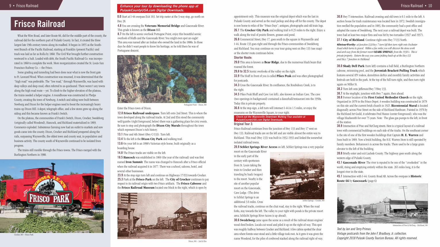
0.0 Start at I-44 overpass Exit 163. Set trip meter at the 3-way stop, go north on Hwy 28.4.8 You are crossing the Veterans Memorial Bridge and Gasconade River. This grade is known as the Dixon Hill.8.7 On the left is scenic overlook Portugese Point, enjoy this beautiful scenic overlook of bluffs and the Gasconade River. You might even spot an eagle!This area was named after an Indian who owned the land in the 1800s. In thosedays he didn’t want people to know his heritage, so he told them he was ofPortuguese descent.
12.8 Frisco Railroad underpass. Turn left onto 2nd Street. This is where thetown developed along the railroad tracks. At 2nd and Elm stood the communitywell/gazebo (right foreground, below) there was a gathering place for civic events.Be sure to stop and photograph the Dixon City Murals throughout the town which represent Dixon’s rich history.
23.9 At the stop sign turn left and continue on Highways 17/I33 towards Crocker. 25.3 Park at the Frisco Park on the left. The City of Crocker continues to pay respect to its railroad origin with two Frisco artifacts. The Frisco Caboose and the Frisco Railroad Museum located one block to the right, which is open by
Enter the Frisco town of Dixon.
13.1 Pine and 4th Street (Hwy C/133). Turn left.13.4 To the left is the Dixon City Park and walking trail.13.6 On your left is an 1890’s Victorian style home, built originally as a boarding house.
14.8 The Frisco tracks are visible on the left.18.5 Hancock was established in 1869 (the year of the railroad) and was first named Iron Summit. The name was changed to Hancock after a Frisco official when the railroad acquired it in 1877. There was a school, saloons, hotel, and several other businesses.
Crocker, MO – Frisco Park
Portuguese Point – Dixon, MO
Dixon, MO – 2nd & Elm
Enhance your tour by downloading the phone app atPulaskiCountyUSA.com Digital Downloads.
appointment only. This museum was the original depot which was the last in Pulaski County and served as the mail pickup and drop-off for the county. The depot is now home to relics of the “Frisco Days”; antiques, photographs and old train logs. 26.1 The Crocker City Park and walking trail is 0.25 miles to the right. Enjoy a walk along the trail of prairie flowers, grasses and pond.26.8 Commercial Street, Hwy 17, goes south to the square in Waynesville and I-44. Route 133 goes right and through the Frisco communities of Swedeborg and Richland. You may continue on your tour going west on Hwy 133 (see map) or the shorter route continues below. Shorter Route:29.0 This area is known as Bear Ridge, due to the numerous black bears that roamed the forest.29.8 to 32.5 Scenic overlooks of the valley on the right.33.9 The bluff in front of you is called Pikes Peak and was often photographed for postcards.34.3 Cross the Gasconade River. Its confluence, the Roubidoux Creek, is to the right.34.5 Pikes Peak Bluff and Cave (on left), also known as Indian Cave. The cave (two openings in background) contained a dancehall/restaurant into the 1950s. Today this is private property.36.8 At the stop sign, a left turn will intersect I-44 in 1.5 miles, or enjoy the museums on the Waynesville Square, to your right.
Original Tour 2:Frisco Railroad continues from the junction of Hwy 133 and Hwy 17 west on Hwy 133. Railroad tracks are on the left and are visible almost the entire way to Richland. This road (Hwy 133) was built in 1932-1933 and linked the somewhat isolated railroad towns.28.9 Schlict Springs River Access on left. Schlict Springs was a very popular resort on the Gasconade River in the early part of the century with sportsmen from St. Louis taking the train to Crocker and then traveling by hack (wagon) to the resort. Nearby is the site of another popular resort on the Gasconade, Cave Lodge. (The drive to Schlict Springs is an additional 3.6 miles. Cross the railroad tracks, continue on the chat road, stay to the right. When the road forks, stay towards the left. The valley to your right with ponds is the private resort area; Schlicht Springs River Access is up ahead).30.6 Swedeborg came upon the scene as a result of the railroad steam engines’ wood-fired boilers. Locals cut wood and piled it up on the right-of-way. This spot
was roughly halfway between Crocker and Richland. A few cabins spotted the clear area where forests once stood and a little village took root. As it grew it was given the name Woodend, for the piles of cordwood stacked along the railroad right-of-way.
Schlict Springs – Crocker, MO
Check out the Waynesville Downtown Walking Tour available atPulaskiCountyUSA.com Digital Downloads.
Frisco Railroad • 10
30.8 Hwy T intersection. Railroad crossing and old town is 0.1 mile to the left. A section house for track maintenance was located here in 1872. Swedish immigra-tion swelled the population and in 1883, the community had a post office and adopted the name of Swedeborg. The next year a railroad depot was built. The town had at least two major fires and was hit by two tornados (1927 and 1937).
37.1 City of Richland. Continue right onto Hwy 7/133 North.
38.0 Shady Dell Park (turn left) contains a ball field, a Burlington Northern caboose, swimming pool, and the Jeremiah Brackett Pulling Track which features several ATV rodeos, demolition derbys and monthly family activities andfestivals are held in the park. At the top of the hill turn right, and then turn right again on Miller St.38.3 Turn left onto Jefferson/Hwy 7/Hwy 133.38.7 38.8 Former location of the First United Methodist Church on the right. Organized in 1870 in the Frisco Depot. A wooden building was constructed in 1878 on this site and the current brick church in 1925. Bicentennial Mural is located diagonally across Pine Street on the side of Richland Hardware. Painted in 1976 by the Richland Art Guild, it celebrates Fred Manes (center foreground), who was the village blacksmith for over 75 years. Note: The glass gas pumps to the left, in front of the station
At the stoplight, junction with Hwy 7 again, then ahead.
#DetourWorthy- at Junction I33/Hwy 7 turn left then turn right onto Rochester Road which turns to gravel. Within a few miles you will discover the stone work and arch way from the former resort OZARK SPRINGS, from the 1930’s. This is private property. Return the way you came picking back up at the Hwy I33 and Hwy 7 Junction in Richland.
38.9 Intersection of Pine and McClurg streets. Here is a typical layout of a railroadtown with commercial buildings on each side of the tracks. On the southeast corneris the site of one of the first wooden buildings that Captain H. E. Warren and Sons built in 1869. Now a brick building, the H.E. Warren Store is still operated byfamily members. Bohannon’s is across the tracks. There used to be a large grain elevator to the left of the building.39.8 Briefly enter and exit Laclede County. The highway goes south along the western edge of Pulaski County.43.1 Gasconade River. The river is reputed to be one of the “crookedest” in the world, rising and emptying entirely within the state. 265 miles long, it is the longest river in the state.45.1 Intersection with I-44. County Road AB. Across the overpass is Historic Route 66 by Gascozark (page 6)
Text by Jan and Terry Primas.Vintage postcards from the John F. Bradbury, Jr. collection.Copyright 2018 Pulaski County Tourism Bureau. All rights reserved.
Intersection of Pine & McClurg – Richland, MO

Fort Leonard Wood Fort Leonard Wood is home to the Army’s Maneuver Support Center which trains over 80,000 engineering, chemical defense and military police enlisted soldiers each year. Named after General Leonard Wood, an Army surgeon, the post opened on December 3, 1941. The Fort was inactivated on March 31, 1946 after WWII and was used for cattle grazing and summer training for Army Reserve and National Guard troops The installation was reactivated August 1, 1950 during the Korean conflict.
Many soldiers have trained over the years, Fort Leonard Wood has grown and prospered. No longer “Fort Lost In the Woods,” the fort has expanded by welcoming
-
divisions of the Marines, Navy, Air Force, and Coast Guard.
Follow the “Blue Line” on the road way from 0.0 -3.9, as you step back in time and learn about the history of Fort Leonard Wood.
For access to the military installation visit wood.army.mil - Real ID link.
11 • Fort Leonard Wood
2.4 Turn left at the stoplight onto North Dakota Ave.2.7 Turn left onto Iowa Ave. You will see the Soldier Memorial Chapel on yourleft and the old Chapel which is currently used as offices on your right.2.8 Baker Theater is on your left.3.2 On your left is Gammon Field. This has been used as the Post’s main parade field since 1941. The field is named in honor of Staff SergeantArcher T. Gammon of Company A, 9th Armored InfantryBattalion, 6th Armored Division. On February 13, 1946, he posthumously received the Medal of Honor for heroism in World War II. Over 3 million soldiers have graduated on Gammon Field. Notice
the white bridge. This bridge is made of 100% recyclable plastic and weighs 1/3 of a normal bridge.3.7 To your left you will see Nutter Field House. This was built in 1942 to provide recreational facilities for soldiers at Fort Leonard Wood. It has a roof truss systemunusual in these types of facilities. It was named for Second Lieutenant Daniel L. Nutter of 25th Armored Engineer Battalion, 6th Armored Division. He was post-humously awarded the Distinguished Service Cross for heroism in World War II.
3.9 Abrahms Theater is on your left and is used as a theater and meeting area. Turn left onto South Dakota Ave.
4.5 On your left is the Mahaffey Museum Complex. Finished in 1970, this hallwas originally constructed to serve as a service club for soldiers, known as WalkerRecreation Center. It is now home to the museums for the Engineer, ChemicalCorps, and Military Police. Learn about history while viewing walk-throughdisplays, life-like exhibits, and decommissioned military equipment which showcase the heritage of those who trained here. The museum is open Monday through Friday from 8AM to 4PM and Saturday from 10AM to 4PM, and closed on Sundays and federal holidays. The museum is free to the general public. Exit themuseum parking lot by turning left, and then right onto Nebraska Ave.4.7 Turn right onto the WWII Mobilization Area, which is part of the Mahaffey Museum Complex. This area includes restored buildings from a company training area built and used during World War II. This locale also includes a chapel used by black soldiers who trained on the post at that time. Also featured are replica barracks of the German POWs who were housed at Ford Leonard Wood. The buildings are open for tours. The outdoor Military Vehicle Museum is also located here.4.8 Memorial Grove and Park islocated to the left, behind the WWII Area. The stones and plaque honor soldiers and units of the three Army branches.The Chemical and Military Police Corpsmemorials were moved to Fort LeonardWood from Fort McClellan, Alabama, Post Headquarters
Nutter Field House
WWII Mobilization Area
FLW Main Gate
Mini Route Drive Time: 25 minutes.Extended Route Drive Time: 1 hour 16 minutes
To enjoy the Parks and Museums allow:Joint Services Park: 30 minutes Mahaffey Museum Complex: 1.5 to 3 hours WWII Restoration Area: 1-2 hours Memorial Grove and Park: 30 minutes Stone Mill Spring: 45 minutesRolling Heath Schoolhouse: 10 minutes Sandstone Spring Trail: 1 hour Fort Leonard Wood Main Gate
Enhance your tour - click our phone app atPulaskiCountyUSA.com Digital Downloads.
0.0 Start Here. At the Sverdrup Gate (Main Gate on Missouri Avenue) set trip meter where traffic merges into two lanes after checkpoint. You are heading south on Missouri Ave. In 1940 the War Department decided to establish a major training area in the Seventh Corps area. This command comprised most of the states in the central plains. Originally located near Leon, Iowa, the site for the new training center was moved to south central Missouri. In the first days of December 1940, military and state officials broke ground for what was known as the Seventh Corps Area Training Center. In early January, the name was changed to Fort Leonard Wood.2.0 To the right, historic markers note the location of the original Post Headquarters which was built in 1941 and demolished in 2012. You will see remains of the stone foundation which was built by German POW's during WWII.
2.2 At the intersection of Missouri Ave. and North Dakota Ave. is the Joint Services Park which was established in honor of all branches of the military that train onFort Leonard Wood. Continue through the intersection. Turn left, parking is located behind. Leave the parking lot by turning right onto Missouri Ave.
Fort Leonard Wood • 12
as part of the relocation of the Chemical and Military Police Schools in 1999. A half mile walk winds through this beautiful park. Exit Memorial Grove and WWII Mobilization Area parking lot by turning left onto Nebraska Ave.5.0 Intersection of Nebraska Ave. and South Dakota Ave. At this point you may continue on the Extended Tour which includes the golf course, walking trails and the one-room schoolhouse or continue with the Mini Tour to the right.
Extended TourIncludes walking trails and one room school.5.0 Turn right onto South Dakota Ave. Follow road, then turn rightonto Piney Hills Drive. (Reset your trip meter to 0)6.0 Turn right onto FLW 25.7.2 Turn right on FLW 26 and cross the one-lane bridge to the golf course.7.5 Piney Valley Golf Course clubhouse. The 18-hole golf course is open to the public. Continue on FLW 26 past the golf course.8.9 Turn right onto dirt road.9.7 Stay to the right for parking area. Stone Mill Spring is approximately a 0.25 mile walk. With a flow of 18 million gallons of water a day, the spring provides excellent fishing. It is stocked with over 3,000 lbs. of rainbow trout per year. The site is named for a historic mill that began operation in the 1880’s. Leave the parking area the way you came in.11.1 Turn left onto FLW 26. Go past the golf course, across the one-lane bridge.12.1 At intersection turn right.12.4 On your left is the Rolling Heath Schoolhouse. The one-room schoolhousewas built in 1912, grades 1–8 were taught here until 1941. The building was restoredin 1995 and is currently used by nature, historical, and civic groups. The SandstoneSpring Trail behind the school that leads though the woods is approximately 1 mile. Exit by turning left onto FLW 25.13.8 Happy Hollow Picnic area is located on the right approximately 1 mile. Exit the picnic area, turn right onto FLW 25, turn left onto Piney Hills Road, left onto South Dakota Ave.17.8 At the intersection of South Dakota and Nebraska reset your trip meter to 0 and turn right. Rejoin the mini tour below.
Mini Tour Continued…5.0 (Reset Your Trip Meter to 0.0) Continue on Nebraska Ave.6.2 Turn right (at stoplight) onto Replacement Ave., to Michigan Ave. Rockwell Historic Cemetery is on right6.3 Turn left onto Michigan Ave. Pull into parking lot behind Candlewood Suites 6.5 Garlington House, built in 1942, on the left. Depart north side of parking lot, turning left onto MP Drive. 6.6 Turn Right on Nebraska Ave.6.7 Turn left onto North Dakota7.0 Merge slightly to right onto Missouri Ave. The General Leonard Wood Army Community Hospital is on your right. The present facility, completed in 1966, is a six-story structure. The original hospital was a cantonment style hospital (many different buildings, without hallways linking them), compromised of over 2,000 beds located from 1941-1965 at the current MANSCEN site.
7.3 Current site of MANSCEN (Maneuver Support Center)8.8 Military Vehicle Display Park on your right.8.9 Exit Fort Leonard Wood.
Scenic Drive:Waggener Gate (West gate to Fort Leonard Wood). I-44 Exit 156, south on Hwy H to Waggoner Gate. Approximately 5 miles of breathtaking views of the Ozark Mountains.
Vintage postcards from the Terry Primas collection.Copyright 2018 Pulaski County Tourism Bureau. All rights reserved.
Visit our county-wide American Hero’s Veterans Memorial Tour at PulaskiCountyUSA.com Digital Download page.
Memorial Grove

13 • Historic Auto Tour Map
FORTLEONARD
WOOD
BIGPINEYRIVER
BIGPINEYRIVER
GASCONADERIVER
Decision Point
GASCONADE RIVER
N
ROUB
IDO
UX R
IVER
44
28
17
17
133
133
133
133
133
7
2817
28
TT
MM
AW
E
H
AA
O
Z
Z
NN
PP
Y
U
BB
KK
HH
AB
K
J
DN
P
U
C
T
DD
Richland
Swedeborg
Crocker
Dixon
Waynesville
Hancock
Frank’sSwitch
W
EXIT150
EXIT145
EXIT153
EXIT156
EXIT163
EXIT161
1744
Buckhorn
Laquey
DukeBig
Piney
Palace
Devil’sElbow
B
EXIT159
St. Robert
J
EXIT169
Waggener Gate
Sverdrup Gate
To Interstate 44 Exit 161 (2 mi.)
Missouri Ave
To Waynesville Regional Airport
(TBN)
Nebraska Ave.
Iowa Ave
Piney Valley Golf Course
Rolling Heath One-Room School
Stone Mill Spring
Happy Hollow
Decision Point
South Dakota
Indiana Ave.
Buckeye Ave
North Dakota Ave
Piney Hills Drive
Fort Leonard Wood
Use these maps as a reference for the
Helpful tip: Access our interactive online tour for detailed mapping instructions and additional stops along each of our three tours!
three routes around Pulaski County: Route 66, Fort Leonard Wood and Frisco Railroad. Traveling all the routes will take you to all of the towns in Pulaski County. Following is a brief summary of the history of Pulaski County and its towns.
Route 66 Tour
Frisco Railroad Tour
Pulaski County History • 14
Historical Notes for Pulaski CountyFounded in 1833 and named for the Polish patriot, Count Casimir Pulaski, the county originally comprised an area that included the present counties of Laclede and Wright, plus most of Dallas, Webster, Phelps, Texas, Camden, and Miller Counties. It was reorganized several times and by 1859 had its present boundaries. For well over a century it has drawn tourists and sportsmen to its scenic beauty, clear streams, and abundant wildlife. It drew the U. S. Army in 1940. Fort Leonard Wood was constructed as a basic training center. Building the fort was a gigantic project, bringing 32,000 construction workers to the area. Over 600 buildings, 300 miles of road, and a 14 mile railroad spur were built in six months. An isolated rural county, population took a jump with the coming of the railroad in 1869. It leveled off at just over 10,000 through 1940 when it took a bigger jump. Fort Leonard Wood was deactivated in 1946 but reopened for training in 1950. The Fort is now the premier training installation for the Engineers, Military Police, Chemical warfare for basic and AIT (advanced), training. All branches of the U.S. Military are represented on the installation. The fortunes of the county are closely tied to Fort Leonard Wood. Pulaski County remainsa rural Ozark area but with a global influence from Fort Leonard Wood.
WaynesvilleThe town was founded in 1843 when one of the early settlers, William Moore, deeded 25 acres for the establishment of the county seat of Pulaski. It was named for a Revolutionary War hero, “Mad Anthony” Wayne. The town was located on the St. Louis-Springfield Road and was served thrice weekly by stagecoach. Most of the county’s commerce and legal business was conducted in the village until the railroad created several new villages to the north in 1869. In June of 1862, the Union Army, under command of Colonel Albert Sigel, occupied the town andbuilt a fort on the hill overlooking the square. The town (and county) had definite southern sympathies, since most of the settlers were from Kentucky, Tennessee, and North Carolina. Enmity was soon put aside after the War of Rebellion and men from both sides of the conflict held county offices. As the railroad towns grew in size and influence, there were several attempts to move the county seat to Crocker and Richland but tradition and upstart town rivalries kept it in Waynesville. With the establishment of Route 66 and later I-44, the waning of the railroads, and the building of Fort Leonard Wood, Waynesville continues to be the center for legal affairs and has regained its place as a hub of economic activity.
St. RobertThe area now occupied by St. Robert had been known as Gospel Ridge from the 19th to the mid-20th century. Its location at the intersection of U. S. 66 and the entrance to Fort Leonard Wood made this area a strip of bars, services, and other entertainments for the troops being trained at the fort. Rev. Robert J. Arnold established a Catholic church in 1951. The church and incorporated area both bore the name of his patron saint, Saint Robert Bellarmine.
CrockerAs the railroad construction progressed across the county, the railway built a depot at the present site of Crocker. There was a trading post called Humboldt about a mile to the northwest. The depot was to serve the communities of Waynesville, Iberia, Hawkeye, Brumley, and Toronto. The shipping center attracted a few businesses and by 1871 the businessmen of Humboldt had relocated to Crocker, leaving Humboldt a memory. Crocker continues to grow in size and commerce along with the economy. The building of Fort Leonard Wood breathed new life into thecommunity and has continued to have an economic impact.
DixonMilton Santee, a surveyor for the railroad, laid out the town in 1869. His configuration straddled the tracks, a half mile on each side. At the intersection of the principal streets 2nd and Elm, a square was formed with a deep well. Above the well was a pagoda which served as a bandstand and podium for civic events. Although the railroad passed as a major influence in Dixon’s economic life, it left a vibrant community. It attracts new residents who are looking for that small town atmosphere.
RichlandMilton Santee was certainly busy in 1869. He laid out the town of Richland on railroad land on each side of the tracks and a depot was constructed. The next year was a boom year for building as businesses were constructed before there were any dwellings. A source of pride was the establishment, also in 1870, of the Richland Institute, a private academy, whose shareholders were the members of the community. The foundation of a growing and prosperous community had been laid. Other small incorporated communities include Laquey, Devils Elbow, Buckhorn, Hancock, Swedeborg, Hawkeye, Franks, Big Piney and Palace.
ROUTE 66
FRISCO RAILROAD
HISTORIC FORT LEONARD WOOD
Historic Driving ToursWe hope you enjoy our historic and scenic auto tours.
Here are other activities for your pleasure.
Over 3,600 motel rooms Military Police, Engineer and Chemical Corps Museums WWII Building Complex & Outdoor Military Vehicle
Museum Canoe Trips on the Gasconade and Big Piney Rivers Trout fishing along the Roubidoux River Quaint antique shops on our Antique & Sweets TrailTrail of Tears Monument
Relive the Civil War era to the1950s while touring the Old Stagecoach StopStep back in time at the Pulaski County Courthouse MuseumEthnic and American restaurants4 Scenic golf coursesCrystal clear springsFrisco MuseumState-of-the-Art Visitors Center
FOR MORE INFORMATION VISITPulaski County Tourism Bureau
137 St. Robert Blvd., Suite ASt. Robert, MO 65584
Phone: 573-336-6355Toll Free: 1-877-858-8687
#PulaskiCountyUSA #Rt66
DISCOVER THE HISTORIC ROADS AND SITES OF Pulaski County USA
Revised Edition