hillsdale park master plan 2006
TRANSCRIPT
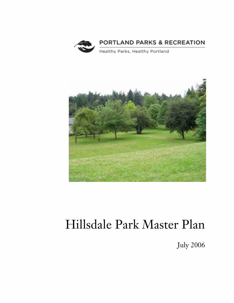
Hillsdale Park Master PlanJuly 2006
Project Staff
Portland Parks & Recreation
Robin Grimwade, Strategy, Finance and Business Development ManagerJanet Bebb, Strategic Projects ManagerNancy Gronowski, Senior Planner, Project ManagerGay Greger, Public Involvement Coordinator
Cover photo: Hillsdale Park looking south from center of the park
Portland Parks & Recreation1120 SW Fifth Avenue, Suite 1302Portland, OR 97204503-823-PLAYwww.PortlandParks.org
Dan Saltzman, CommissionerZari Santner, Director
Table of Contents Introduction ...................................................................... 1
Purpose of the Master Plan Description and Location of Hillsdale Park Level 1 Master Plan Process Consensus and Optional Elements Plans
Existing Conditions .......................................................... 3Site HistoryZoningLandscape SettingsNatural ResourcesCurrent Development and UseExisting Conditions Aerial Photo Existing Conditions Map
Park and Recreation Trends and Needs ........................... 7Parks, Schools and Open Spaces in the AreaPark and Recreation Trends2020 Planning FrameworkRecreation Assessment Summary
Recommendations .......................................................... 11GoalsManagement RecommendationsSite Development Issues and ConclusionsRecommended Improvements and Implementation Master Plan Master Plan Cost Estimate
Appendix ......................................................................... 19Population Information for the Hillsdale Area

Hillsdale Park Master Plan 1
Introduction
Purpose of the Master Plan
A Level 1 Master Plan is designed to produce a site plan and conceptual development plan forparks that are typically 5 acres or less and that do not have complex issues or concerns. Themaster plan considers the whole park in the context of all parks in the area and provides aunified site plan for use and development. The master plan guides current management andinforms future development when funds become available. For parks with limited developmentfunds, it is a way to develop an agreed-on set of improvements that can be implemented inpartnership with neighbors and park users.
Description and Location of Hillsdale Park
Hillsdale Park is an L-shaped 5+ acre park in southwest Portland located off of Beaverton-Hillsdale Highway a short distance west of the Hillsdale Town Center. It is adjacent to RobertGray Middle School, the Portland Christian Center and The Laurels condominiums.
The park has a variety of landscape settings including open lawns, a wooded hillside and ameadow area. The park is generally undeveloped. A dog off-leash area is located in the northend of the park by a Portland Christian Center parking lot.
The park has been in the Portland Park & Recreation (PP&R) system since 1952. Over theyears a number of proposals for developing the park have been advanced; none has come tofruition.
Level 1 Master Planning Process
The process involves initial inventory and research work by staff, public involvementconsisting of an initial newsletter and questionnaire, a community design workshop, theposting of plans on PP&R’s web site, a public comment period and a review of the results withthe community. The result is a final site plan and a written summary document.
Consensus and Optional Elements Plans
The community design workshop for Hillsdale Park resulted in two plans – a minimaldevelopment consensus plan that all participants agreed to, and an optional elements plan thatincluded additional improvements. Those plans were made available to the public forcomment. There was strong support for all elements of Consensus plan and generally strongsupport for the proposed Optional Elements plan.

Hillsdale Park Master Plan 2
Hillsdale Park Master Plan 3
Existing Conditions
Site History
ACQUISITION
The two parcels (1.36 and 3.81 acres) that make up the majority of Hillsdale Park wereacquired in 1952. A 10’ wide strip of land for the old road that goes from the Beaverton-Hillsdale Highway to the north part of the park was acquired in a land swap with the Assemblyof God church (now the Portland Christian Center) in 1974. The road originally providedaccess to a house and barn in the area now occupied by the church parking lot. A few orchardtrees remain in the park when it was a farmstead.
PRIOR DEVELOPMENT PROPOSALS
Over the years, a number of proposals have been advanced for the park. A 1952 drawing showsfull development of the current park area and some areas around it. The plan included anamphitheater north of the current sports fields at Robert Gray, a football field, four tenniscourts, a swimming pool, field house / bath house, children’s play area, picnic grove and aparking lot behind the condominiums.
In 1979, the Bridlemile / Robert Gray Association, on behalf of 397 petitioners, sent a letter toMildred Schwab, Commissioner for Public Affairs, requesting play fields and development ofthe park as a community and recreation center.
As part of a package of bond project soccer fields, Portland Parks &Recreation proposedbuilding a soccer field and small parking lot in1996. When a synthetic grass field - capable ofaccommodating much more use - was built at Mary Rieke, that proposal was dropped. Overthe years, Portland Christian Center has offered to buy or develop parts of the park foradditional parking. None of these proposals has materialized.
Zoning
The park is zoned OS (Open Space). The surrounding area is mainly single family residential(R7 and R10) with multi-family (R2) residential units along Beaverton-Hillsdale Highway.
There is an area of Commercial zoning on Capital Highway about a mile east of the park andanother area of Commercial zoning on Beaverton-Hillsdale Highway about two miles west ofthe park.
Landscape Settings
The park has a variety of settings ranging from wooded to pastoral open meadow. Most of thepark consists of rolling or steep land. There are four general areas within the park: the off-leash meadow in the north, the wooded knoll in the center, the open slope and orchard in theeast section and the lawn with mature trees in the southwest.
Hillsdale Park Master Plan 4
Conifers are prevalent in the south part of the park and a number of old orchard trees exist atthe foot of the open south-facing slope by The Laurels. There are approximately 170 treeslarger than 6” dbh1 and 30 of those are 20” or larger. Another 30 trees are located in the B-HHwy right-of-way, including 4 significant sequoias (32”, 36”, 40” and 44” dbh).
The midpoint of the site has steep south-facing slopes (50% in places), and north-facing slopesof about 15% down to the PCC parking lot. Most of the site is in grass, either rough mownthree times a year (north end) or maintained as lawn with weekly mowing (the remainder ofthe site).
Natural Resources
There are few significant natural resources in Hillsdale Park and no environmental overlays.Native trees include Douglas fir and alder. Other trees are ornamental trees, orchard trees ornon-native invasives. The TNC (The Nature Conservancy) vegetation classification is closedforest, upland forest.
Conditions that would have existed in 1851 are identified as FFHC Bu Mesic mixed coniferforest with mostly deciduous understory. The forest could have included Douglas fir, westernhemlock, red cedar, grand fir, big leaf maple, yew, dogwood, white oak, and red alder.
There are springs located in the north portion of the park that are most evident in the winterand spring. A stream with a P-zone overlay is located north of the park on church, school andresidential properties.
Current Development and Use
Except for the off-leash area, there is little development in the park. One picnic table is locatedon the wooded knoll. Primary use of the park is for individual, self-directed activities such aswalking, relaxing on the sunny slope in the summer, or sledding in the winter.
1 dbh: diameter at breast height, measured 4 ½ ‘ from the ground
Hillsdale Park Master Plan 5
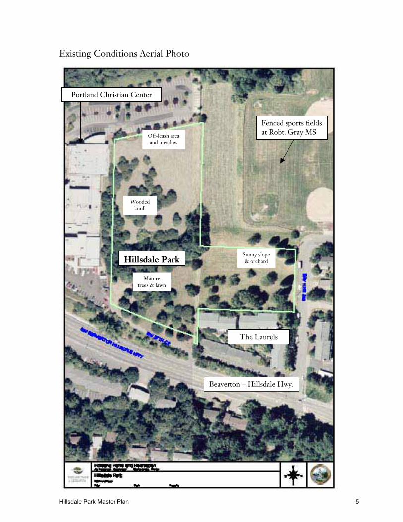
Existing Conditions Aerial Photo
Fenced sports fieldsat Robt. Gray MS
Hillsdale Park
Portland Christian Center
Off-leash areaand meadow
Beaverton – Hillsdale Hwy.
The Laurels
Woodedknoll
Sunny slope& orchard
Maturetrees & lawn
Hillsdale Park Master Plan 6
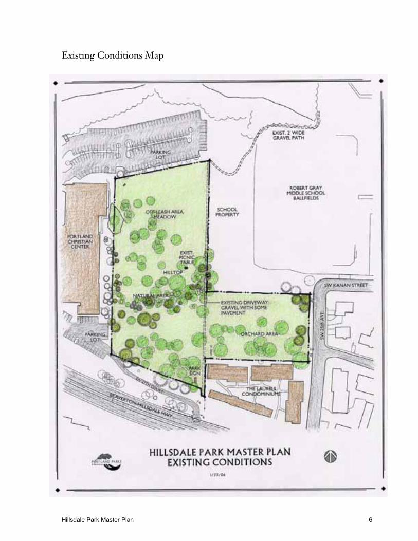
Existing Conditions Map
Hillsdale Park Master Plan 7
Park and Recreation Trends and Needs
The most basic role of local parks is to provide basic recreation opportunities for self-directedand informal activities such as walking for pleasure or for exercise, neighborhood gatherings,children’s play and informal sports. Portland baseline service level for neighborhood parks is2.5 acres per 1,000 population. As a whole, the Southwest sub-area has above averageneighborhood and community park land with 3.85 acres per 1000 people. However, terrain inthe southwest makes it difficult to provide traditional park amenities like sports fields andaccess to parks is often difficult due to the lack of sidewalks.
Because of its site conditions, Hillsdale Park can only accommodate some of the parkimprovements that are typically found in developed neighborhood parks. These includeplaygrounds, paths, benches and tables, open lawn areas, and shrub beds. Sports fields cannotbe accommodated without extensive grading.
The following recreation assessment is based on an analysis of several conditions and factorssuch as proximity to other parks, recreation trends, a review of PP&R plans, and a review ofparticipation patterns.
Parks, Schools and Open Spaces in the Area
PARKS
The Hillsdale Neighborhood is located in an area where residents have few options fortraditional recreation opportunities such as a playground, open lawn, and walking paths. Theclosest parks with these amenities are Gabriel Park (89.4 ac.) and Albert Kelly Park (12.1 ac.),both about 0.50 - 0.75 mile away. Each includes a variety of park facilities but because ofterrain, distance, and lack of sidewalks are not considered to be within walking distance forchildren and most families with small children.
SCHOOLS
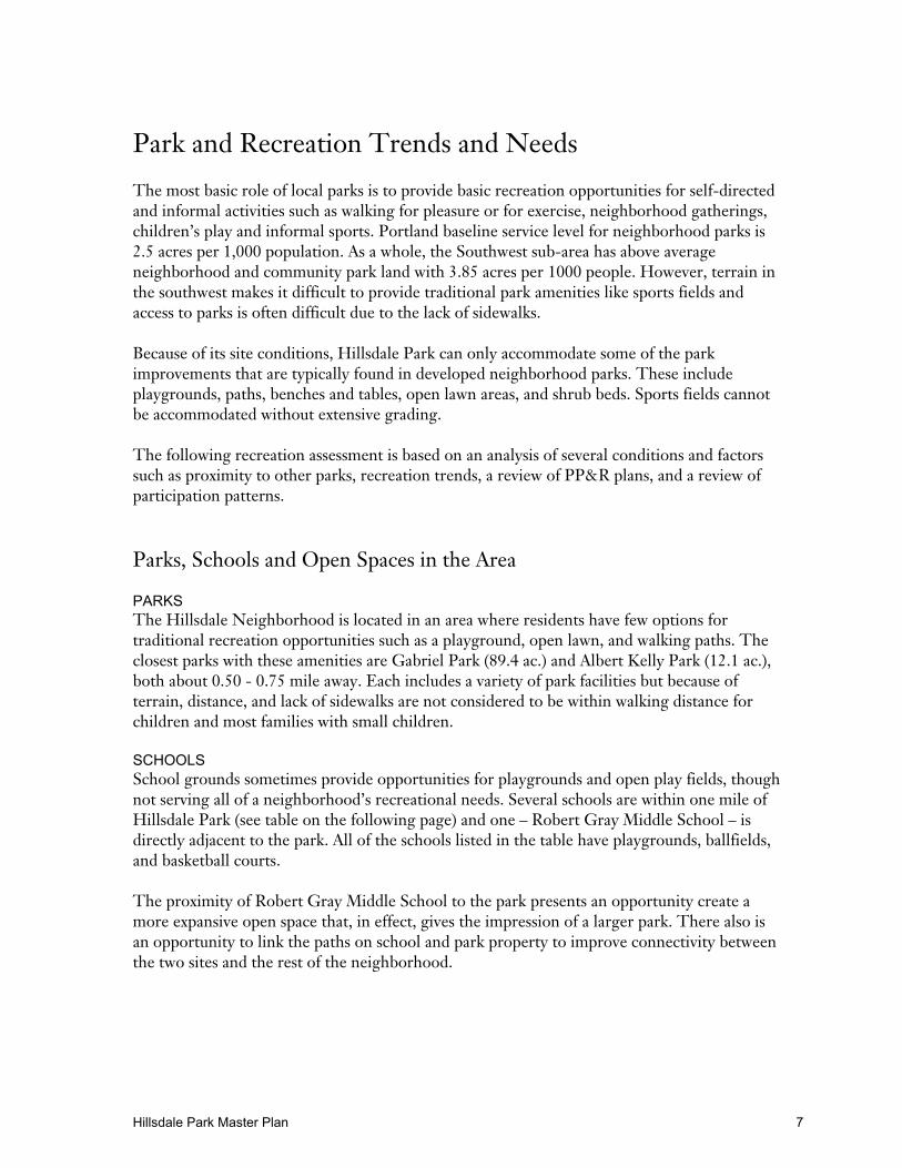
School grounds sometimes provide opportunities for playgrounds and open play fields, thoughnot serving all of a neighborhood’s recreational needs. Several schools are within one mile ofHillsdale Park (see table on the following page) and one – Robert Gray Middle School – isdirectly adjacent to the park. All of the schools listed in the table have playgrounds, ballfields,and basketball courts.
The proximity of Robert Gray Middle School to the park presents an opportunity create amore expansive open space that, in effect, gives the impression of a larger park. There also isan opportunity to link the paths on school and park property to improve connectivity betweenthe two sites and the rest of the neighborhood.
Hillsdale Park Master Plan 8
Summary of Parks and Schools in the Vicinity of Hillsdale Park
Parks Within A One- Mile Radius of Hillsdale Park
Facilities
Site SizeAcres
Playgd. BallfieldsSportsFields
Basketball(Outdoors)
Tennis Restrooms
Gabriel Park 89.41 3 2 1 8 1
George Himes Park 31.69 -- -- -- -- -- --
Albert Kelly Park 12.09 1 1 -- -- --
Custer Park 6.47 1 1 -- -- 1
Multnomah Art Center 5.35 -- -- 1 -- 1
Stephens Creek NaturalArea
3.36 -- --- -- -- -- --
Healy Heights Park 1.19 1 1 1 -- --
Dewitt Park 1.09 -- -- -- -- --
Schools Within A One- Mile Radius of Hillsdale Park
Facilities
Site SizeAcres
Playgd. BallfieldsSportsFields
Basketball(Outdoors)
Tennis Restrooms
Gray Middle School 13.32 4 1 5 -- NA
Rieke Elementary School 12.99 1 1 -- -- NA
Wilson High School 22.75 -- 3 2 2 2 NA
Source: 2020 Refinement Plan, Portland Parks & Recreation, 2003
Park and Recreation Trends
A trend that is expected to affect the use of Hillsdale Park is overall population growth in thecity. Between 1990 and 2000, the U.S. population increased by 13% while the Portland –Vancouver area grew by 27%. This growth results from strong growth in both states, ties tothe Pacific Rim, and the area’s quality of life.
As Portland grows both in number and in density, there will be greater demands on parks andrecreational facilities. Parks will be used more intensively. Parks such as Hillsdale, which havetraditionally had lower levels of visitation because there are no improvements, will experiencegreater use as the park is developed and improved with recreation facilities.
In the period 1990 – 2000, population in the area around Hillsdale Park changed very little(see table on page 11). Total population increased slightly; there were minor increases in thepercent of Asian/Pacific Islanders, Hispanics, and children under 17. Conversely, the percentof older people (over 65) decreased slightly.
Hillsdale Park Master Plan 9
DEMAND FOR PARKS AND RECREATION FACILITIES AND SERVICES
The need for recreation improvements is based also on surveys and other studies that describehow people feel about current park facilities, how they recreate now, and what improvementscould be provided to accommodate desired and appropriate uses.
The 2005 Citywide Survey conducted by the City of Portland provides another index of recreation need. Results from the survey revealed that Hillsdale neighbors are generallysatisfied with park and recreation services. The neighborhood ranked 15th out of 76neighborhoods in satisfaction with the overall quality of parks and in closeness to parks.Other variables (feeling of safety, recreation programs, etc.) also were ranked relativelyhigh.
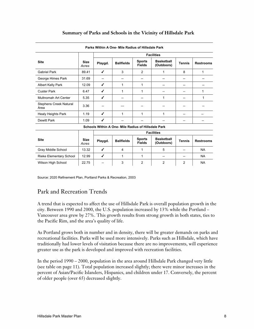
The 2004 Survey of Residents by Portland Parks & Recreation provides a more detailedlook at recreation needs for the city’s six sub-areas. The need for a variety of parkimprovements for the Southwest sub-area (generally defined as the area south of Hwy. 26)is shown in the table below.
Park Improvement % supporting
Swimming poolsNatural wildlife areas
Gardens
474641
Trails for bikingDog off-leash area
4040
Trails for hiking/runningPlaygrounds
3635
Grass sports fieldsSkate parks
Group picnic areasBaseball fields
34342417
Tennis courts 13
The survey also revealed that the Southwest sub-area has the highest percentage of“empty-nesters” in the city. These are the second largest segment (24 percent) of Portlandresidents, second to “playground parents.” The empty nester segment has the lowestoverall intensity of use of park and recreation facilities and the second lowest percentage ofpark users (73%). This segment’s members are generally older Caucasian females, unlikelyto have children living in the home, with relatively higher annual household incomes. Theplayground parent segment has the highest intensity use of traditional park and recreationfacilities.
When asked about priorities for new park and recreation improvements, respondents werealmost evenly split between traditional facilities (playgrounds, ballfields, etc.) and morenatural areas and trails. Support for natural areas and trails was among the highest of thesix sub-areas in the city.
According to PP&R studies and recommended levels of service, the only currentdeficiencies in the Southwest sub-area for active sports facilities are basketball courts
Hillsdale Park Master Plan 10
(seven are needed). If populations increase as expected by 2020, the sub-area will need ninebasketball courts and one ball field.
Play areas are especially important in neighborhood parks because they provide areas forchildren to exercise and recreate in safe conditions. They should serve a range of ages andprovide a variety of stimulating experiences. Ideally, areas for toddlers are separate fromfacilities for older children. While generally speaking, Southwest has sufficient play areas,access is often difficult due to terrain and lack of sidewalks.
Group picnic areas accommodate larger groups of people for outdoor eating withnumerous tables and often with shelters, electricity and water. Southwest has sufficientgroup picnic areas.
Off-leash areas are defined as areas that are designated for recreating with dogs off-leash.
2020 Planning Framework
The Parks 2020 Vision document provides a broad planning framework for PP&R’s system. Inthe Southwest sub-area, the 2020 report notes that the area’s hilly topography, lack ofimproved streets, and poor street connectivity makes access to parks difficult in some areas.The report recommends that Hillsdale Park be developed as a neighborhood park, one of fivein Southwest that are currently unimproved.
Recreation Assessment Summary
The Hillsdale neighborhood has a limited number of easily accessible developed parks. The park is in an area of park deficiency and few options exist for residents.Population growth and increasing density will result in an overall increase in use atHillsdale Park.
Consequently, Hillsdale Park is, and is expected to be in the future, important for meeting thebasic recreational needs of the immediate residents as well as neighbors from other areas,especially those to the west. With the proximity of sports fields at the adjacent Robert GrayMiddle School, Hillsdale will serve an important role in reducing park deficiency inSouthwest.
Hillsdale Park Master Plan 11
Recommendations
This section describes the proposed management and development improvements agreed toby the community and PP&R during the master planning process. These recommendationsare based on the following goals developed at the community design workshop.
Goals
Provide safe recreation experiences.
Maintain and enhance the current character of the park2.
Provide a variety of signage3.
Provide improved access and parking.
Provide a clean and well-maintained park and school grounds.
Develop partnerships to help enhance the park and encourage community ownership.
Provide a balance of appropriate unstructured activities and accessibility4 for all ages and
abilities.
Management Direction and Recommendations
Maintain and enhance native vegetation in the treed area; remove invasives.
Develop a parking and access agreement with PCC to enable park users to use the churchparking lot.
Develop a use agreement between schools and parks for L-shaped property adjacent topark below school sports fields.
Minimize development that would generate an inappropriate level of vehicular traffic frompark activity.
Do not consider development of a parking lot on park property.
Site Development Issues and Conclusions
The following issues were identified and discussed at the July 2005 community designworkshop with the following conclusions:
2 In particular, maintain and enhance the existing tree canopy and the historic orchard.3 Both directional and interpretive signage4 Accessibility in and to the park is limited by the topography.
Hillsdale Park Master Plan 12
LIMITED PUBLIC PARKING FOR PARK USERS
Due to the configuration of Hillsdale Park, public parking is only available along SW 25th andKanan streets. Church parking lots adjacent to the park on the north and west sides aregenerally available to the public. However, there are times when the church needs all of theirparking for church functions.
Conclusion: Work with the church to continue use of their parking lots and develop specificuse agreements if possible. Explore the possibility of developing a few parking spots in theBeaverton – Hillsdale Highway right-of-way, if they can be provided without negativelyimpacting the existing mature trees. Note: It is important to not add impervious surfaces thatwill increase run-off and negatively impact water quality in the Fanno Creek watershed; infact, it is desirable to reduce runoff and improve water quality wherever possible.
DOG OFF-LEASH AREA
The off-leash area has been in place since 2003. Design workshop attendees agreed that it isfunctioning well. The off-leash hours are limited from 5:00 a.m. to 8:00 a.m. and 4:30 p.m.until closing to minimize conflicts with the church, the school, other park users and neighbors.Much of the success of this site comes from its effective separation from the rest of the park.The neighborhood is actively involved in ensuring compliance with off-leash rules.
Conclusion: Continue current efforts to keep this area working as intended, and ensure thatactivities in the off-leash area do not negatively affect water quality for the creek located northof the park.
PEDESTRIAN ACCESS TO THE PARK
Much of the access to the park comes through school or church property. This requires thatpark users respect the needs of those property owners and if necessary, have acceptableagreements in place for access across their property.
Conclusion: Work with the church and the school to continue to use their properties to accessthe park and provide connectivity in the neighborhood. Develop specific use agreements orrecreation easements. Designate appropriate paths as “Safe Routes to School”.
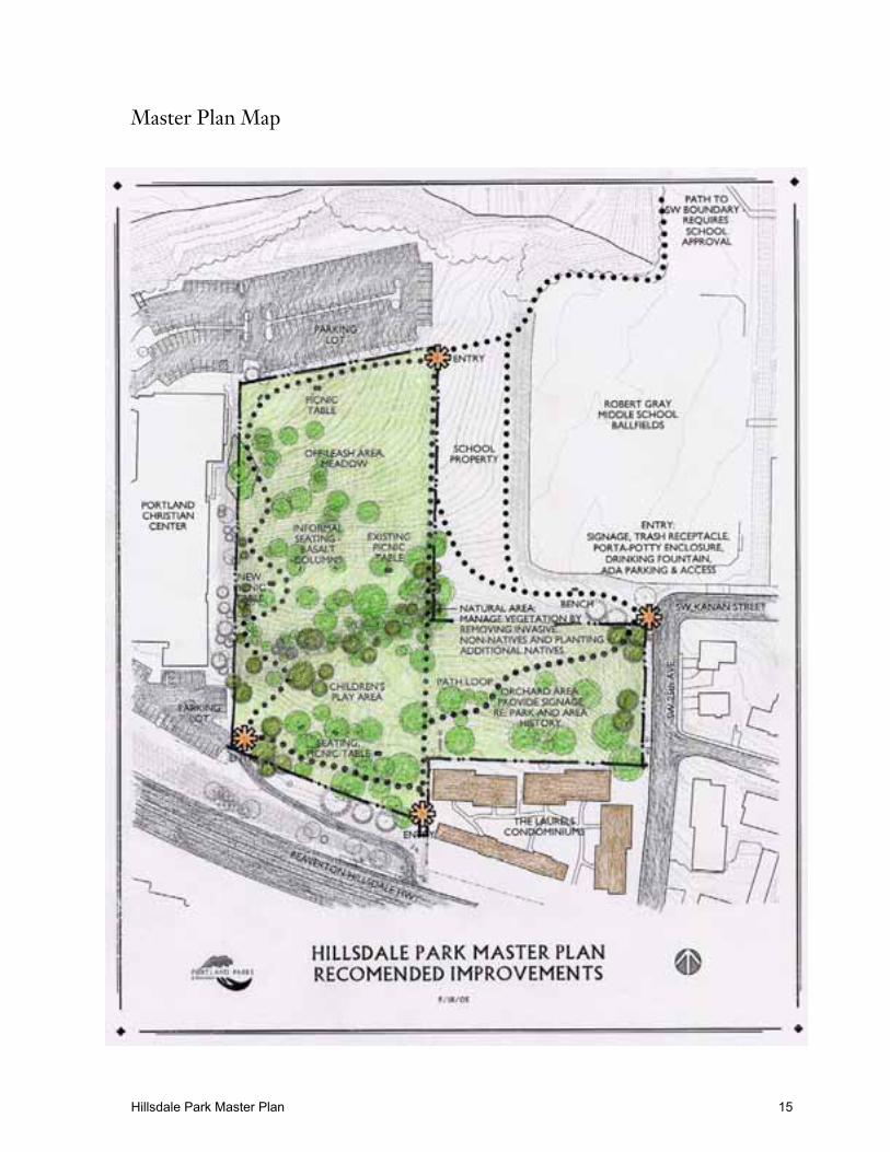
Recommended Improvements and Implementation
The final master plan (see map on page 15) includes the agreed-on improvements from theOptional Elements plan. These improvements are conceptual. As funding becomes available,PP&R will work with the community to design, build and install the park improvements. Parkimprovements will be built to PP&R standards to ensure public safety and accessibility.
Hillsdale Park Master Plan 13
MASTER PLAN ELEMENTS
The elements are described from north to south.
Loop Trail and Paths The loop trail will be built primarily on park property. As much of the trail as possible will bebuilt to accommodate those with disabilities, but due to steep terrain in some areas, it may notbe feasible to provide access around the entire loop. PP&R will work with the CCACD (city /county accessibility review group) on park designs to ensure reasonable accessibility.
Any connecting paths on school property require school permission before work is started andmust be built to school district specifications. The school district does not endorse use of theexisting narrow gravel trail outside the fenced sports field in its present condition. The path issteep and narrow with a steep drop to the ravine on the north; grade changes along parts ofthe route are significant. Further investigation of the cost and feasibility of providing a safepathway from the park along its present route to the northern edge of the school site (outsideof the sport field fence) to connect with the footbridge accessing SW Boundary must be donebefore that work can be approved.
Off-Leash Area / MeadowThis area functions very well as an unfenced off-leash area by virtue of its separation from therest of the park and its accessibility via the church’s parking lot and a narrow trail from theschool. The neighborhood works actively to ensure that rules are followed.
Parts of this area are very wet in the winter and spring because of natural springs. Furtherstudy is encouraged to remedy this situation and make the area more usable year-round.Develop protocols to ensure that water quality is not negatively impacted by the off-leash area.
“L-Shaped” School PropertyThe area below the school’s fenced sports fields functions as part of the park even though it isowned by the school district. The community and PP&R would like to develop a permanentagreement for its use that would allow development of connecting trails, consistentmaintenance or other appropriate uses. It is also desirable to develop a collaborativemaintenance agreement with Robert Gray Middle School for certain portions of school andpark property.
Seating and Picnic Tables A few benches and picnic tables will be located in the park in appropriate locations. Thebenches are proposed to be informal in nature using long-lasting natural materials such asbasalt columns.
Main Park Entry at Sw 25th and KananMost elements of this project are located on school property and will require school districtpermission before work can begin. The ADA parking spot is proposed at the intersection ofSW 25th and Kanan. An accessible route will need to be developed from the parking spot tothe main park entry and the trails that emanate from it.
Hillsdale Park Master Plan 14
Elements at the main entry include: a drinking fountain, portable toilet, garbage can anddesignated disabled parking and access at SW 25th and Kanan.
Natural Area Vegetation ManagementThis work consists of removal of non-native invasives and replanting with appropriate nativeplants. PP&R staff will work with community volunteers on the timing of removal andinstallation of plants.
Maintain and enhance the existing tree canopy.
Orchard AreaThe area north of The Laurels condominiums has remnant orchard trees from when this areawas a farmstead. Interpretive signs will be placed here and in other areas of the park to explainits history.
Children’s Play AreaThe community supports an informal children’s play area consisting of more informal playelements rather than traditional swings and teeter-totters.
Parking in Beaverton-Hillsdale Highway Right-of-WaySW 27th Court functions as an exit driveway from the church down to B-H Highway. Theneighborhood association is interested in developing some parking on the north side of thedrive. Portland Department of Transportation is responsible for the right-of-way and anyimprovements in it require their approval and permission. PP&R, as the abutting propertyowner, is responsible for maintenance of elements in the right-of-way.
The following map illustrates the recommended park improvements. Cost estimates on page17 are very preliminary and will be adjusted at the time of design development.
Hillsdale Park Master Plan 15
Master Plan Map

Hillsdale Park Master Plan 16
Hillsdale Park Master Plan 17
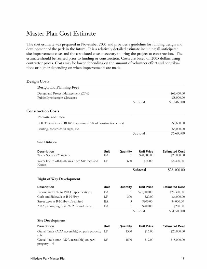
Master Plan Cost Estimate
The cost estimate was prepared in November 2005 and provides a guideline for funding design anddevelopment of the park in the future. It is a relatively detailed estimate including all anticipatedsite improvement costs and the associated costs necessary to bring the project to construction. Theestimate should be revised prior to funding or construction. Costs are based on 2005 dollars usingcontractor prices. Costs may be lower depending on the amount of volunteer effort and contribu-tions or higher depending on when improvements are made.
Design Costs
Design and Planning Fees
Design and Project Management (20%) $62,460.00
Public Involvement allowance $8,000.00
Subtotal $70,460.00
Construction Costs
Permits and Fees
PDOT Permits and ROW Inspection (15% of construction costs) $3,600.00
Printing, construction signs, etc. $3,000.00
Subtotal $6,600.00
Site Utilities
Description Unit Quantity Unit Price Estimated CostWater Service (2" meter) EA 1 $20,000.00 $20,000.00
Water line to off-leash area from SW 25th andKanan
LF 600 $14.00 $8,400.00
Subtotal $28,400.00
Right of Way Development
Description Unit Quantity Unit Price Estimated Cost
Parking in ROW to PDOT specifications EA 1 $21,300.00 $21,300.00
Curb and Sidewalk at B-H Hwy LF 300 $20.00 $6,000.00
Street trees at B-H Hwy if required EA 5 $800.00 $4,000.00
ADA parking signs at SW 25th and Kanan EA 1 $200.00 $200.00
Subtotal $31,500.00
Site Development
Description Unit Quantity Unit Price Estimated Cost
Gravel Trails (ADA accessible) on park property- 6'
LF 1300 $16.00 $20,800.00
Gravel Trails (non-ADA accessible) on parkproperty - 4'
LF 1500 $12.00 $18,000.00
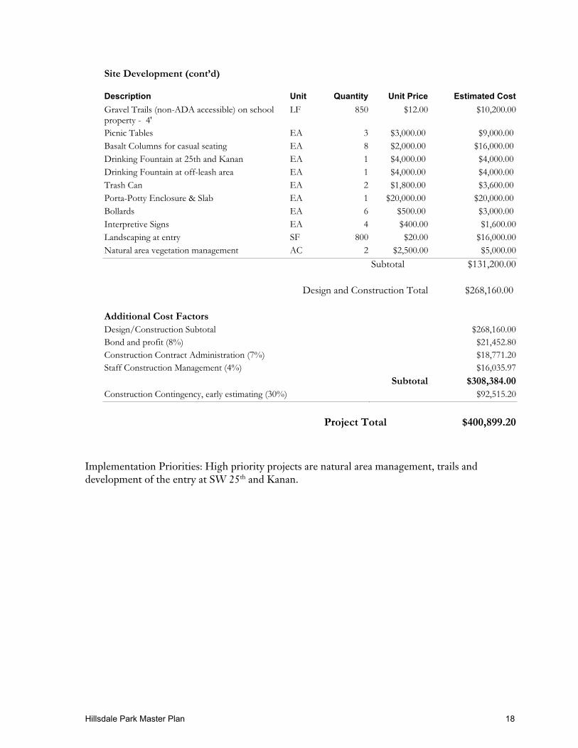
Hillsdale Park Master Plan 18
Site Development (cont’d)
Description Unit Quantity Unit Price Estimated Cost
Gravel Trails (non-ADA accessible) on schoolproperty - 4'
LF 850 $12.00 $10,200.00
Picnic Tables EA 3 $3,000.00 $9,000.00
Basalt Columns for casual seating EA 8 $2,000.00 $16,000.00
Drinking Fountain at 25th and Kanan EA 1 $4,000.00 $4,000.00
Drinking Fountain at off-leash area EA 1 $4,000.00 $4,000.00
Trash Can EA 2 $1,800.00 $3,600.00
Porta-Potty Enclosure & Slab EA 1 $20,000.00 $20,000.00
Bollards EA 6 $500.00 $3,000.00
Interpretive Signs EA 4 $400.00 $1,600.00
Landscaping at entry SF 800 $20.00 $16,000.00
Natural area vegetation management AC 2 $2,500.00 $5,000.00
Subtotal $131,200.00
Design and Construction Total $268,160.00
Additional Cost FactorsDesign/Construction Subtotal $268,160.00
Bond and profit (8%) $21,452.80
Construction Contract Administration (7%) $18,771.20
Staff Construction Management (4%) $16,035.97
Subtotal $308,384.00Construction Contingency, early estimating (30%) $92,515.20
Project Total $400,899.20
Implementation Priorities: High priority projects are natural area management, trails anddevelopment of the entry at SW 25th and Kanan.
Hillsdale Park Master Plan 19
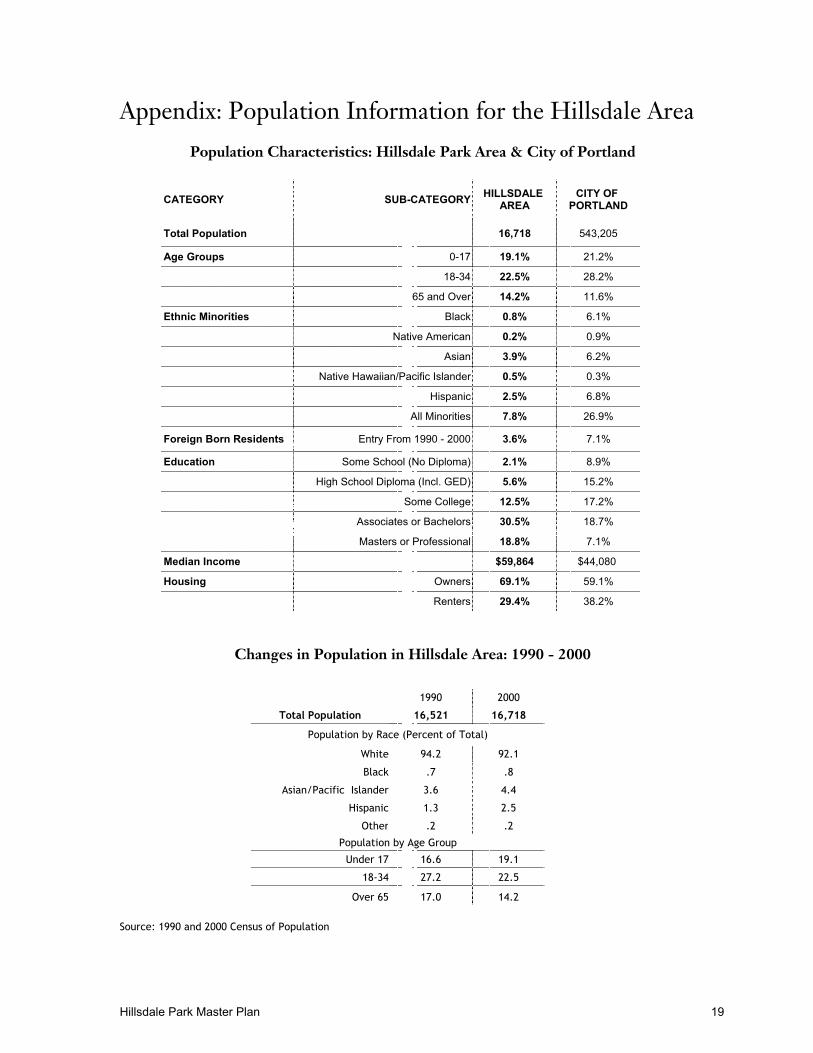
Appendix: Population Information for the Hillsdale Area
Population Characteristics: Hillsdale Park Area & City of Portland
CATEGORY SUB-CATEGORYHILLSDALE
AREACITY OF
PORTLAND
Total Population 16,718 543,205
Age Groups 0-17 19.1% 21.2%
18-34 22.5% 28.2%
65 and Over 14.2% 11.6%
Ethnic Minorities Black 0.8% 6.1%
Native American 0.2% 0.9%
Asian 3.9% 6.2%
Native Hawaiian/Pacific Islander 0.5% 0.3%
Hispanic 2.5% 6.8%
All Minorities 7.8% 26.9%
Foreign Born Residents Entry From 1990 - 2000 3.6% 7.1%
Education Some School (No Diploma) 2.1% 8.9%
High School Diploma (Incl. GED) 5.6% 15.2%
Some College 12.5% 17.2%
Associates or Bachelors 30.5% 18.7%
Masters or Professional 18.8% 7.1%
Median Income $59,864 $44,080
Housing Owners 69.1% 59.1%
Renters 29.4% 38.2%
Changes in Population in Hillsdale Area: 1990 - 2000
1990 2000
Total Population 16,521 16,718
Population by Race (Percent of Total)
White 94.2 92.1
Black .7 .8
Asian/Pacific Islander 3.6 4.4
Hispanic 1.3 2.5
Other .2 .2
Population by Age Group
Under 17 16.6 19.1
18-34 27.2 22.5
Over 65 17.0 14.2
Source: 1990 and 2000 Census of Population