high tide waterbird roost mapping on the ... - solway firth roost... · high-tide waterbird roost...
TRANSCRIPT
Page 1 of 37
High-tide Waterbird Roost Mapping on the Solway Firth, Cumbria
April 2016
Solway Firth Partnership, Campbell House, The Crichton, Bankend Road, Dumfries, DG1 4UQ
Page 2 of 37
List of Contents
1. Introduction .............................................................................. 3
1.1 Aims and Objectives .............................................................. 4
2. Study Site and Methods ........................................................... 5
2.1 Site ........................................................................................ 5
2.1.1 Brief Description .............................................................. 5
2.1.2 Designated Sites ............................................................. 5
2.2 Methods ................................................................................ 9
2.2.1 Target Species ................................................................ 9
2.2.2 Data Collection and Analysis ........................................... 9
3. Results and Discussion .......................................................... 11
3.1 Solway WeBS Data and Importance Thresholds ................. 11
3.2 WeBS Data Broken Down into Sections .............................. 14
3.2.1 Section 1: Rockcliffe ...................................................... 14
3.2.2 Section 2: Sandsfield to Dykesfield ............................... 15
3.3.3 Section 3: Dykesfield to Glasson ................................... 15
3.3.4 Section 4: Glasson to Herdhill Scar ............................... 16
3.3.5 Section 5: Herdhill Scar ................................................. 16
3.3.6 Section 6: Herdhill Scar to Cardurnock .......................... 16
3.3.7 Section 7: Anthorn to Newton ........................................ 17
3.3.8 Section 8: Newton Arlosh & 9. Calvo Marsh .................. 18
3.3.9 Section 10: Grune Point ................................................ 19
3.3.10 Section 11: Silloth West Beach to Skinburness ........... 20
3.3.11 Section 12: Beckfoot to Silloth .................................... 20
3.3.12 Section 13: Mawbray to Beckfoot ................................ 21
3.3.13 Section 14: Meolo to Mawbray .................................... 21
3.3.14 Section 15: Bankend to Blue Dial ................................ 22
3.3.15 Section 16: Maryport ................................................... 23
3.3.16 Section 17: Workington to Flimby ............................... 23
4. Conclusion and Recommendations .......................................... 24
5. References ............................................................................... 26
6. Appendices ............................................................................... 27
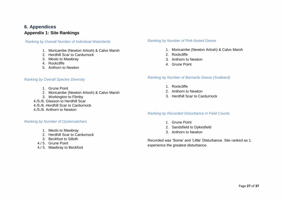
Appendix 1: Site Rankings ........................................................ 27
Ranking by Overall Number of Individual Waterbirds ............. 27
Ranking by Overall Species Diversity .................................... 27
Ranking by Number of Oystercatchers .................................. 27
Ranking by Number of Pink-footed Geese ............................. 27
Ranking by Number of Barnacle Geese (Svalbard) ............... 27
Ranking by Recorded Disturbance in Field Counts ................ 27
Appendix 2: BTO Species Codes for Target Species ................ 28
Appendix 3: Roost Sites with Grid References .......................... 29
Page 3 of 37
1. Introduction Waterbirds are an integrated part of the global ecosystem. Many
waterbirds migrate long distances, often in large numbers. This
makes them “visible and charismatic” (1). Over the last decades a
number of data collection schemes such as the International
Waterbird Consensus (IWC) have made it possible to monitor and
review the status of waterbirds across the globe. All data on
waterbirds informs and supports the Ramsar Convention on
Wetlands which sets the key targets of identifying wetlands of
international importance, conservation and research priorities and
knowledge gaps (2). On a European level, the EU Bird Directive
provides a legal framework for the monitoring and protection of
birds (3).
The Solway Firth Estuary is the 8th most important habitat for non-
breeding waterbirds across the UK (4). The total sum, a five year
average, of all waterbird species present in the Solway is 109,297
individual birds.
The five year trends show a slight decrease in numbers. While the
Solway enjoys a high ratio of nature designations to population size
and spread, the interest of private, commercial and governmental
sectors for the purposes of recreation, tourism, energy or other is
growing.
Various academic researchers (5, 6) have identified the impact of
disturbance on high-tide roosts as a key factor influencing the
quality of a particular waterbird habitat. While the frequency and
type of disturbance need to be taken into consideration to decide
how substantial a given case of disturbance is, it is also important to
consider the number and composition of species and their
abundance at a site. It is therefore of critical importance to identify
avian biodiversity ‘hotspots’ to avoid cumulative and long-term
damage to the natural intrinsic and commercial value of the Solway
Coastline, its people, culture and heritage for generations to come.
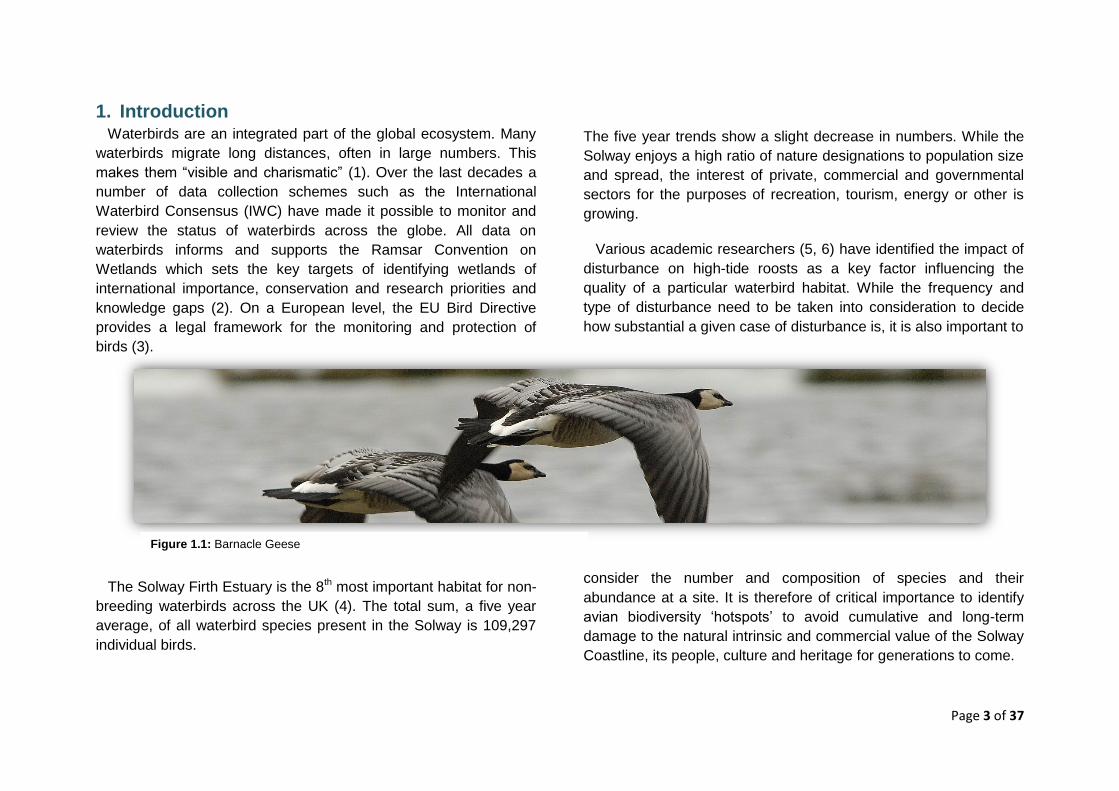
Figure 1.1: Barnacle Geese
Page 4 of 37
1.1 Aims and Objectives
This section lists the aims set for this study which are hoped to be
achieved through the following objectives.
The information provided in this report has the potential to inform
and support:
The general public
Key stakeholders in conservation, planning, management
and development
o Local Authority Planning
o Local Nature Reserves
Legislation and frameworks
o SSSI Detailed Notification Review and condition
monitoring
o Implementation of Marine and Coastal Access Act
(2009) - Coastal access and footpath networks
o International Waterbird Consensus
o Habitat Regulations Assessments
Aim 1: To identify and highlight local avian ‘hotspots’ along the
Solway Estuary on a small spatial scale by providing
evidence of the location of peak high tide roost counts.
Objective 1.1: Build relationships between local
partners (SFP, RSPB and local WeBS counters)
Aim 2: To inform existing protection and management frameworks
and measures.
Objective 2.1: Identify presence, frequency and
severity of disturbance.
Objective 1.2: Compare surveyed sites to allow
prioritisation.
Objective 2.2: Identify knowledge gaps.
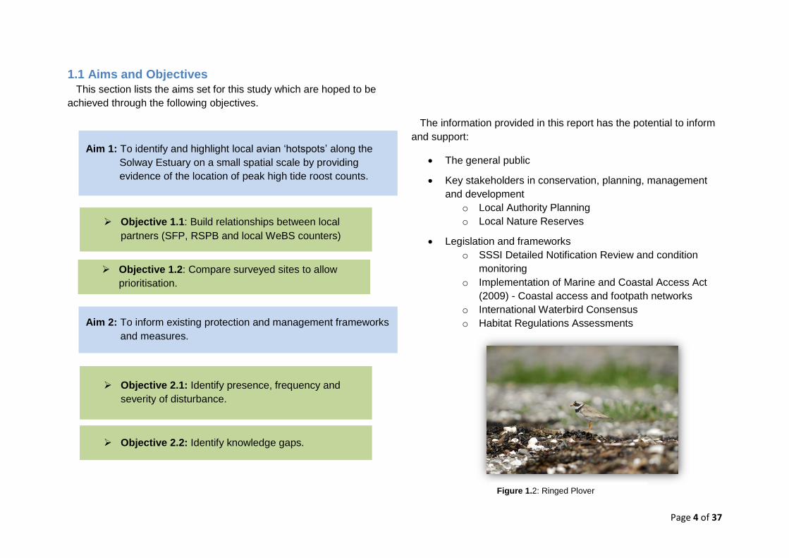
Figure 1.2: Ringed Plover
Page 5 of 37
2. Study Site and Methods
2.1 Site
2.1.1 Brief Description
The Solway offers one of Britain’s largest continuous intertidal
habitats. The habitat consists of about 93% tidal flats, 6% salt
marshes and 1% sand and shingle shores which include dune
systems (7). The tidal flats, mud and sand are the habitat of many
invertebrates. Key species, providing food for a large number of
waterbirds are (7): ragworm (Hediste diversicolor), lungworm
(Arenicola marina), various bivalves such as Baltic tellin (Macoma
balthica), snails e.g. mudsnail (Hydrobia ulvae), and the amphipod
mudshrimp (Corophium volutator). The prime food sources for
waterbirds are common blue mussels (Mytilus edulis) and common
cockles (Cerastoderma edule).
The tidal mudflats offer ideal place for roosting. Roosts are areas
in which waders and other waterbirds can be found when pushed
landwards away from their low tide feeding grounds at high tide
(13). Roost sites such as the Solway are of great significance as
they need to be safe from predation and allow the birds to save
energy needed for moult, maintenance metabolism and migratory
fuelling (13). As a result, roost sites are as important as feeding
grounds. A high frequency of disturbance can thus strongly
influence the health and breeding success of a species and in the
worst case lead to population decline.
The South side of the Solway Firth estuary stretches from
Rockcliffe Marsh to St Bees Head in Cumbria and provides habitats
for a great variety of wildlife. Typical for this stretch of landscapes
are saltmarshes, peatbogs, farmland and wet grassland. Besides
various site designations (see section 2.1.2), the English side of the
Solway hosts an Area of Outstanding Natural Beauty (Solway Coast
AONB) and two RSPB Nature Reserves; RSPB Campfield Marsh
and RSPB St Bees Head. Campfield Marsh is known for breeding
lapwings and redshanks and wintering swans, ducks and geese in
their thousands as well as large number of roosting waders at high
tide (8).
2.1.2 Designated Sites
The Solway is subject to a large number of nature designations
(9). Areas of the inner Solway Firth are designated both as a
Special Area of Conservation (SAC) under the Habitats Directive
(10) and a Special Protection Area (SPA) under the Birds Directive
(11) – collectively known as the Solway Firth European Marine Site
(EMS). The Solway Firth SAC designation reflects the importance
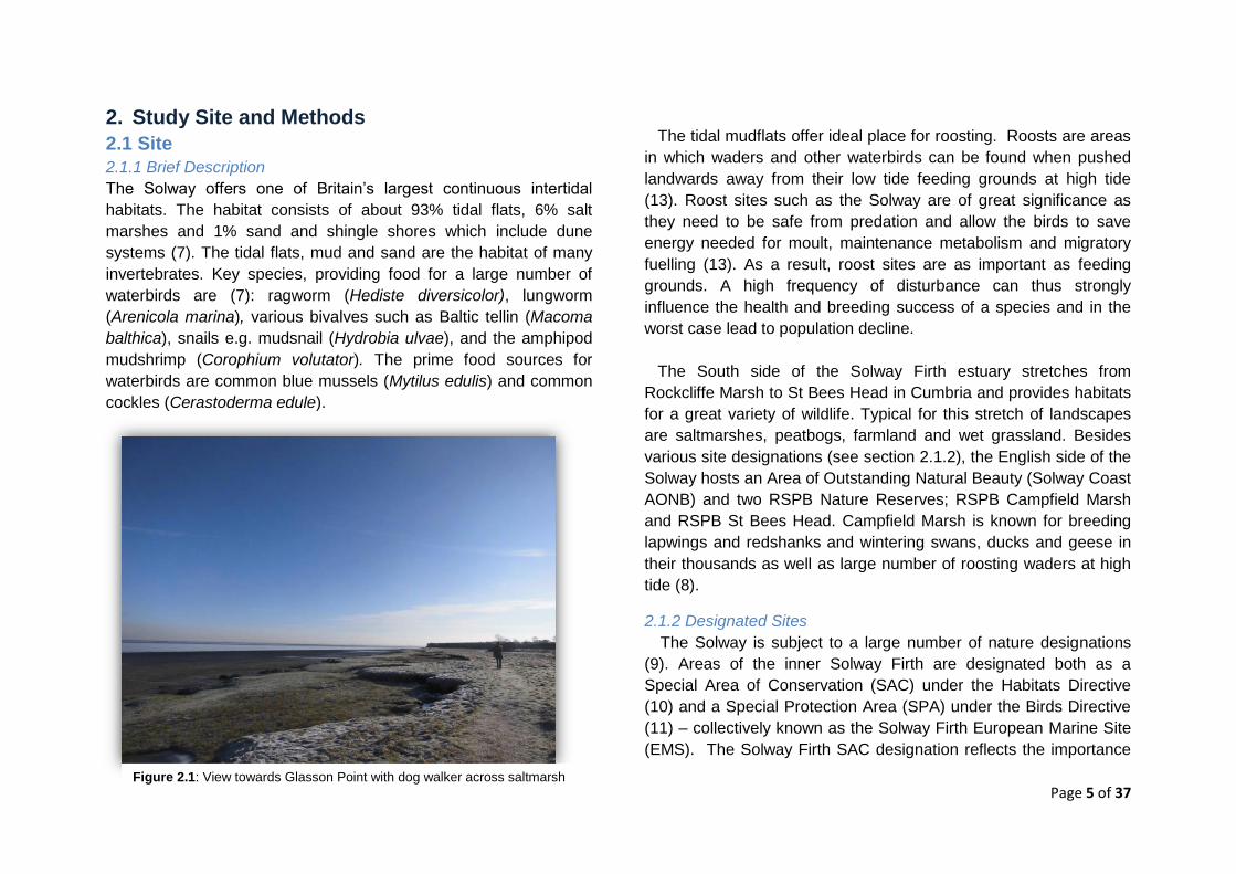
Figure 2.1: View towards Glasson Point with dog walker across saltmarsh
Page 6 of 37
of the site’s marine and coastal habitats including merse
(saltmarsh), mudflats and reefs. The Upper Solway Flats and
Marshes SPA designation recognises the large bird populations that
these habitats support, particularly in winter (9). Important bird
species include Svalbard Barnacle Goose (Branta leucopsis), Pink-
footed Goose (Anser brachyrhynchus), Whooper Swan (Cygnus
cygnus) and Pintail (Anas acuta) as well as waders such as Bar-
tailed Godwit (Limosa lapponica), Golden Plover (Pluvialis
apricaria), Oystercatcher (Haematopus ostralegus), Dunlin (Calidris
alpina), Knot (Calidris canutus), Curlew (Numenius arquata) and
Redshank (Tringa totanus).
There is currently a proposal under consideration to extend the
boundary of the SPA designation (4). The qualifying bird species in
the Solway Firth marine draft SPA include Annex 1 species: Red-
throated diver (Gavia stellate); migratory species: Common Scoter
(Melanitta nigra) and Goosander (Mergus merganser); and
migratory species from the 2001 SPA Review: Ringed Plover
(Charadrius hiaticula), Lapwing (Vanellus vanellus), Cormorant
(Phalacrocorax carbo), Herring Gull (Larus argentatus), Common
Gull (Larus canus) and Black-headed Gull (Chroicocephalus
ridibundus). It is anticipated that the ministerial approval to formally
consult on the draft SPA will be given in 2016.
Additionally, in English waters, the first tranche of Marine
Conservation Zones (MCZs) were designated in November 2013
under the UK Marine and Coastal Access Act (12). This was a
significant step towards creating a network of marine protected
areas and an achievement for the conservation of important marine
species and habitats. Within the surveyed area Allonby Bay,
including Dubmill Scar and the offshore area of Maryport Roads, is
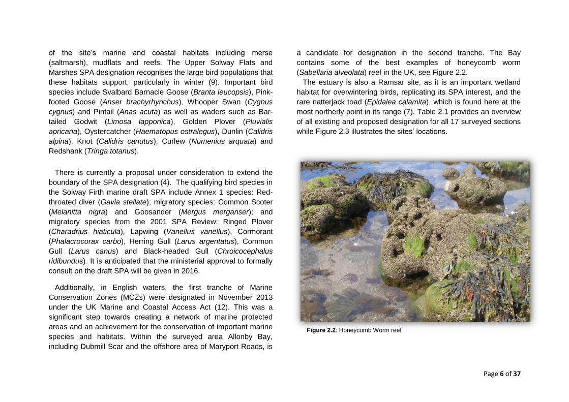
a candidate for designation in the second tranche. The Bay
contains some of the best examples of honeycomb worm
(Sabellaria alveolata) reef in the UK, see Figure 2.2.
The estuary is also a Ramsar site, as it is an important wetland
habitat for overwintering birds, replicating its SPA interest, and the
rare natterjack toad (Epidalea calamita), which is found here at the
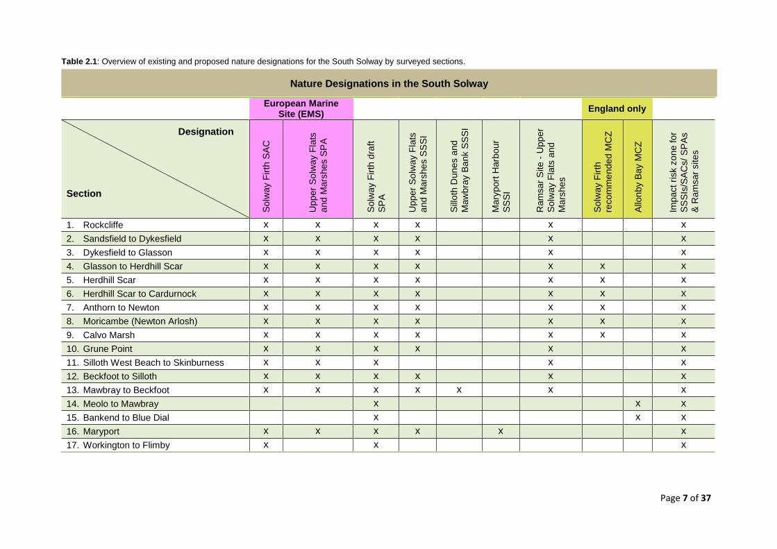
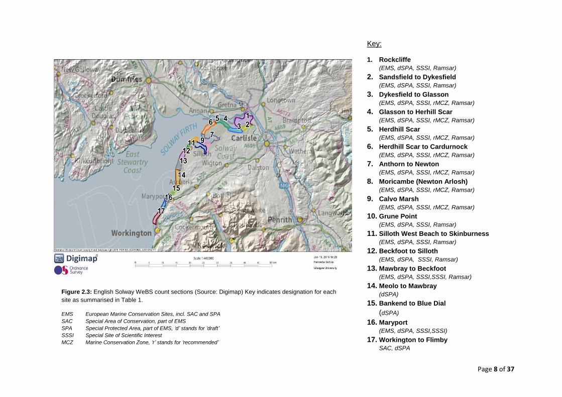
most northerly point in its range (7). Table 2.1 provides an overview
of all existing and proposed designation for all 17 surveyed sections
while Figure 2.3 illustrates the sites’ locations.
Figure 2.2: Honeycomb Worm reef
Page 7 of 37
European Marine Site (EMS)
England only
Designation
Section
Solw
ay F
irth
SA
C
Upper
So
lway F
lats
and M
ars
hes S
PA
Solw
ay F
irth
dra
ft
SP
A
Upper
So
lway F
lats
and M
ars
hes S
SS
I
Sill
oth
Dunes a
nd
Maw
bra
y B
ank S
SS
I
Mary
port
Harb
our
SS
SI
Ram
sar
Site
- U
pp
er
Solw
ay F
lats
an
d
Mars
hes
Solw
ay F
irth
recom
me
nde
d M
CZ
Allo
nby B
ay M
CZ
Impact ri
sk z
one for
SS
SIs
/SA
Cs/
SP
As
& R
am
sar
sites
1. Rockcliffe x x x x x x
2. Sandsfield to Dykesfield x x x x x x
3. Dykesfield to Glasson x x x x x x
4. Glasson to Herdhill Scar x x x x x x x
5. Herdhill Scar x x x x x x x
6. Herdhill Scar to Cardurnock x x x x x x x
7. Anthorn to Newton x x x x x x x
8. Moricambe (Newton Arlosh) x x x x x x x
9. Calvo Marsh x x x x x x x
10. Grune Point x x x x x x
11. Silloth West Beach to Skinburness x x x x x
12. Beckfoot to Silloth x x x x x x
13. Mawbray to Beckfoot x x x x x x x
14. Meolo to Mawbray x x x
15. Bankend to Blue Dial x x x
16. Maryport x x x x x x
17. Workington to Flimby x x x
Nature Designations in the South Solway
Table 2.1: Overview of existing and proposed nature designations for the South Solway by surveyed sections.
Page 8 of 37
Figure 2.3: English Solway WeBS count sections (Source: Digimap) Key indicates designation for each
site as summarised in Table 1.
EMS European Marine Conservation Sites, incl. SAC and SPA
SAC Special Area of Conservation, part of EMS
SPA Special Protected Area, part of EMS, ‘d’ stands for ‘draft’
SSSI Special Site of Scientific Interest
MCZ Marine Conservation Zone, ‘r’ stands for ‘recommended’
Key:
1. Rockcliffe
(EMS, dSPA, SSSI, Ramsar)
2. Sandsfield to Dykesfield (EMS, dSPA, SSSI, Ramsar)
3. Dykesfield to Glasson (EMS, dSPA, SSSI, rMCZ, Ramsar)
4. Glasson to Herhill Scar (EMS, dSPA, SSSI, rMCZ, Ramsar)
5. Herdhill Scar (EMS, dSPA, SSSI, rMCZ, Ramsar)
6. Herdhill Scar to Cardurnock (EMS, dSPA, SSSI, rMCZ, Ramsar)
7. Anthorn to Newton (EMS, dSPA, SSSI, rMCZ, Ramsar)
8. Moricambe (Newton Arlosh) (EMS, dSPA, SSSI, rMCZ, Ramsar)
9. Calvo Marsh (EMS, dSPA, SSSI, rMCZ, Ramsar)
10. Grune Point (EMS, dSPA, SSSI, Ramsar)
11. Silloth West Beach to Skinburness (EMS, dSPA, SSSI, Ramsar)
12. Beckfoot to Silloth (EMS, dSPA, SSSI, Ramsar)
13. Mawbray to Beckfoot (EMS, dSPA, SSSI,SSSI, Ramsar)
14. Meolo to Mawbray (dSPA)
15. Bankend to Blue Dial
(dSPA)
16. Maryport (EMS, dSPA, SSSI,SSSI)
17. Workington to Flimby SAC, dSPA
Page 9 of 37
2.2 Methods
2.2.1 Target Species
The Species included in this report were selected according to
their recorded presence in peak roost counts as reported by
questioned WeBs counters. A total of 21 species were recorded as
roosting along the South Solway high tide margins and flood plains
plus one additional species south of Workington. Table 2.2 lists all
target species with those of international importance highlighted
blue and those of national importance highlighted green. The
locations of individual sections are summarised in Figure 2.3
above.All target species were recorded throughout the year, not
exclusively during the winter months. Within the WeBS counts, gull
species are only recorded on a voluntary basis which lead to their
exclusion from this study (except for Mediterranean Gulls).
2.2.2 Data Collection and Analysis
The data on bird counts and species importance thresholds was
collated from the WeBS Online Report 2013/14 (4). Data on roost
sites and sizes, freshwater outlets and disturbance was collected,
with the assistance of RSPB Campfield Marsh, from individual
WeBS counters responsible for counting the sections along the
South Solway coast. All WeBS counters, familiar with the so-called
‘look-see’ methodology (14), were asked to provide information on
peak roost counts, the species present and the roost locations.
The counters handed in maps with hand-drawn sketches
highlighting roost locations and providing rough estimates of
numbers. The maps were then translated into data points using grid
references and entered into a spreadsheet, which was fed into a
Geographical Information System (GIS) by the Cumbria Biodiversity
Data Centre. As a final outcome, a GIS layer was created
displaying all identified roost sites and points of interest with
information such as disturbance and freshwater outlets.
The analysis of results allowed the interpretation of the collated
data on major roost sites (Table 3.1), existing and planned
designations (Table 2.1 and Figure 2.3), trends and thresholds of
national and international importance (Table 2.2 and Figure 3.2). All
accumulated information thus added to the compliance with the
established aims and objectives stated in section 1.1. To test the
validity of returned peak roost estimates, the data was compared to
figures from the official WeBS count database. While figures were
not expected to be identical, the evident similarities between the
two data sets confidently point towards the roost records being
representative of the total count.
Results of individual roost site peak estimates are presented and
analysed in section 3.2. Standard BTO Species Codes (see
Appendix 2) are employed throughout Tables 3.2 to 3.15.

Page 10 of 37
WeBS Numbers– Solway Estuary (Scottish and English Side)
UK Rank of Site
Importance 5yr avg
(2009-2014) GB
threshold % of GB
threshold International
threshold % of Int.
threshold
Sp
ec
ies
Whooper Swan 13 279 110 254% 270 103%
Pink-footed Goose 16 16,107 3,600 447% 3,500 460%
Oystercatcher 3 23,942 3,200 748% 8,200 292%
Ringed Plover a 5 1,206 340 355% 730 165%
Knot 11 9,553 3,200 299% 4,500 212%
Bar-tailed Godwit 13 1,240 380 326% 1,200 103%
Barnacle Goose (Svalbard) b 3 27,416 330 8,308% 300 9,139%
Shelduck 15 1,529 610 251% 3,000 51%
Goosander a 1 267 120 223% 2,700 10%
Cormorant a 7 821 350 235% 1,200 68%
Golden Plover 10 5,006 4,000 125% 9,300 54%
Sanderling 13 558 160 349% 1,200 47%
Dunlin 17 7,581 3,500 217% 13,300 57%
Eurasian Curlew 6 3,336 1,400 238% 8,400 40%
Redshank 11 2,252 1,200 188% 2,400 94%
Turnstone 11 485 480 101% 1,400 35%
Grey Plover 29 349 430 81% 2,500 14%
Lapwing a 18 4,723 6,200 76% 20,000 24%
Mediterranean Gull 94 2 18 11% 770 <0%
Sandwich Tern 9 351 8,266 4% 1,700 21%
Wigeon 46 2,183 4,400 50% 15,000 15%
Table 2.2: Target species - Solway population trends, national ranking of the Solway and thresholds of importance (4). Blue: International importance; Green: National importance
a Species qualified for protection under SPA (15)
b Solway hosts entire Svalbard population of Barnacle Geese
Page 11 of 37
3. Results and Discussion
3.1 Solway WeBS Data and Importance Thresholds
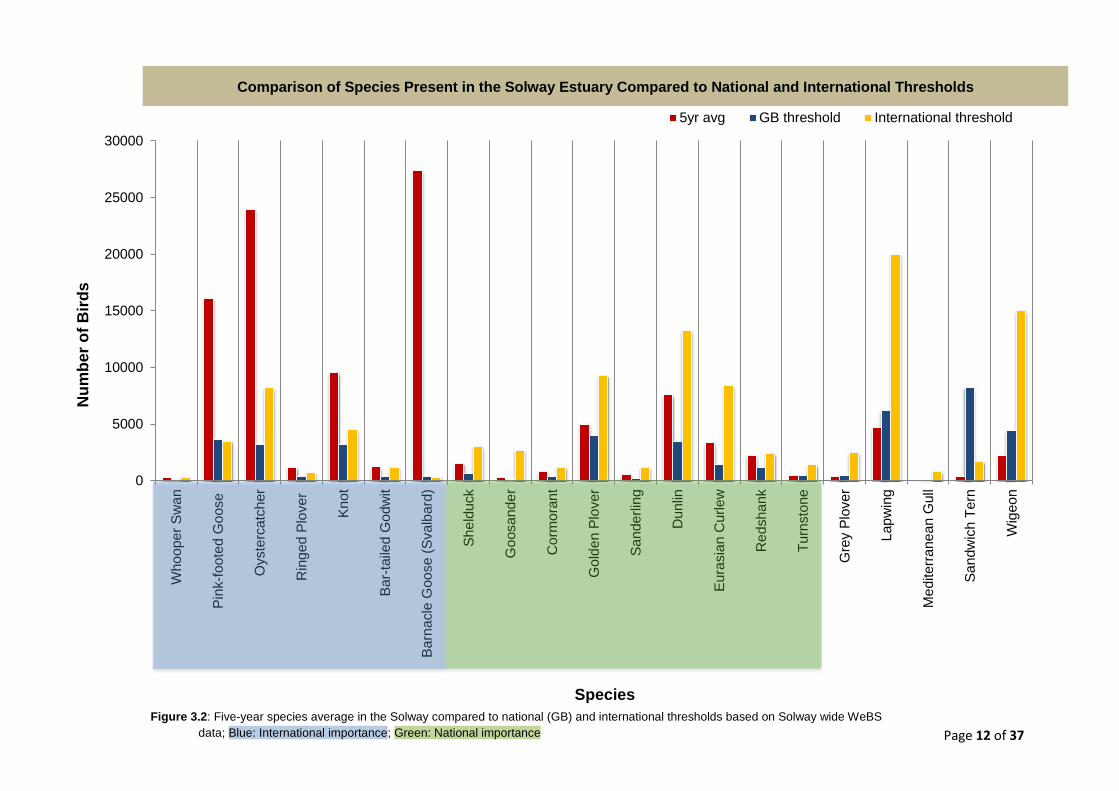
Table 2.2 shows the five-year Solway population averages (2009-
2014) for all 21 target species (4). The table further displays
information on UK and international thresholds of species’
significance as well as the UK rank of the Solway as a habitat.
According to the Ramsar Convention, a site qualifies as
internationally important if it supports at least 1% of the species’
population or more than 20,000 waterbirds in total. Similarly, a site
is of national importance if it supports 1% of the UK waterbird
population estimates. The seven species exceeding the threshold
for international importance are highlighted blue, the nine species of
national importance in green. According to the figures, the Solway
is amongst the top five habitats for four species: Oystercatcher,
Ringed Plover, Goosander and Barnacle Goose. As for the latter,
the Solway hosts the entire Svalbard Barnacle Goose population
during the winter months.
Figure 3.2 illustrates data presented in Table 2.2 comparing the
five-year average of the waterbird species present in the Solway to
national and international thresholds. The two species of greatest
importance in this comparative context are: Oystercatcher,
exceeding the national threshold by 748% and the international
threshold by 292%; and Pink-footed Goose, exceeding the national
threshold by 447% and the international threshold by 460%.
Also noteworthy are the numbers of Barnacle Geese which greatly
exceed both thresholds.
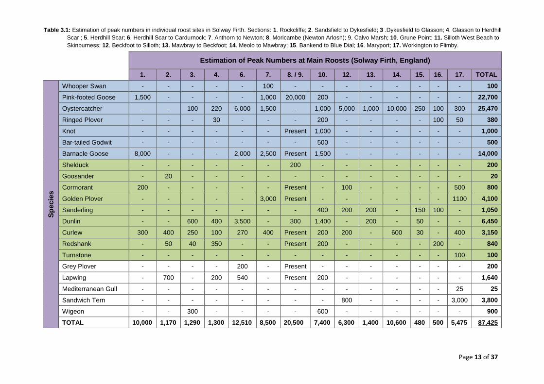
Table 3.1 displays peak roost counts for the Solway, Cumbrian
coast. The table reveals that the largest number of waterbirds,
20,500 individuals, was counted in section 8/9 - Moricambe
(Newton Arlosh)/Calvo Marsh. The second and third most important
sections in terms of total numbers are section 6 - Herdhill Scar to
Cardurnock (12,510 individuals) and section 14 – Meolo to
Mawbray (10,600 individuals).
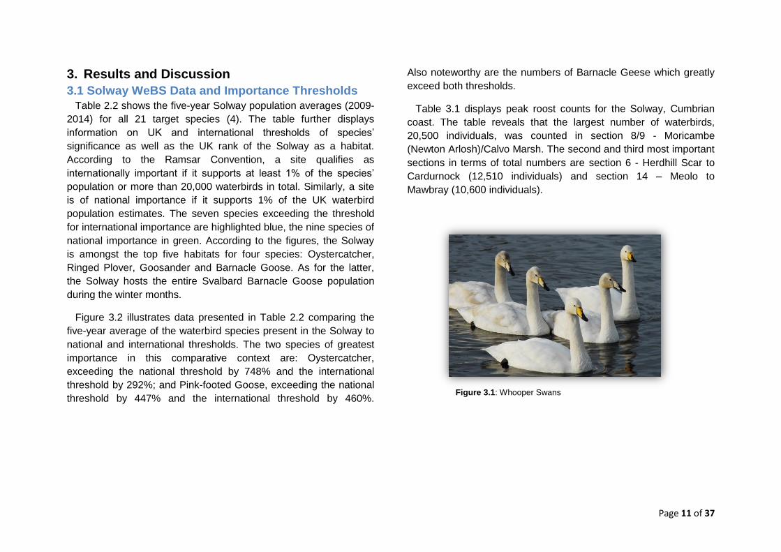
Figure 3.1: Whooper Swans
Page 12 of 37
0
5000
10000
15000
20000
25000
30000
Who
ope
r S
wa
n
Pin
k-f
oo
ted
Go
ose
Oyste
rcatc
her
Rin
ge
d P
love
r
Kn
ot
Ba
r-ta
iled
Go
dw
it
Ba
rna
cle
Goo
se (
Sva
lbard
)
Sh
eld
uck
Go
osa
nd
er
Co
rmo
ran
t
Go
lde
n P
lover
Sa
nde
rlin
g
Du
nlin
Eu
rasia
n C
urle
w
Re
dsh
ank
Tu
rnsto
ne
Gre
y P
love
r
Lapw
ing
Me
dite
rra
ne
an G
ull
Sa
ndw
ich T
ern
Wig
eo
n
5yr avg GB threshold International threshold
Figure 3.2: Five-year species average in the Solway compared to national (GB) and international thresholds based on Solway wide WeBS
data; Blue: International importance; Green: National importance
Comparison of Species Present in the Solway Estuary Compared to National and International Thresholds N
um
be
r o
f B
ird
s
Species
Page 13 of 37
Table 3.1: Estimation of peak numbers in individual roost sites in Solway Firth. Sections: 1. Rockcliffe; 2. Sandsfield to Dykesfield; 3 .Dykesfield to Glasson; 4. Glasson to Herdhill
Scar ; 5. Herdhill Scar; 6. Herdhill Scar to Cardurnock; 7. Anthorn to Newton; 8. Moricambe (Newton Arlosh); 9. Calvo Marsh; 10. Grune Point; 11. Silloth West Beach to
Skinburness; 12. Beckfoot to Silloth; 13. Mawbray to Beckfoot; 14. Meolo to Mawbray; 15. Bankend to Blue Dial; 16. Maryport; 17. Workington to Flimby.
Estimation of Peak Numbers at Main Roosts (Solway Firth, England)
1. 2. 3. 4. 6. 7. 8. / 9. 10. 12. 13. 14. 15. 16. 17. TOTAL
Sp
ec
ies
Whooper Swan - - - - - 100 - - - - - - - - 100
Pink-footed Goose 1,500 - - - - 1,000 20,000 200 - - - - - - 22,700
Oystercatcher - - 100 220 6,000 1,500 - 1,000 5,000 1,000 10,000 250 100 300 25,470
Ringed Plover - - - 30 - - - 200 - - - - 100 50 380
Knot - - - - - - Present 1,000 - - - - - - 1,000
Bar-tailed Godwit - - - - - - - 500 - - - - - - 500
Barnacle Goose 8,000 - - - 2,000 2,500 Present 1,500 - - - - - - 14,000
Shelduck - - - - - - 200 - - - - - - - 200
Goosander - 20 - - - - - - - - - - - - 20
Cormorant 200 - - - - - Present - 100 - - - - 500 800
Golden Plover - - - - - 3,000 Present - - - - - - 1100 4,100
Sanderling - - - - - - - 400 200 200 - 150 100 - 1,050
Dunlin - - 600 400 3,500 - 300 1,400 - 200 - 50 - - 6,450
Curlew 300 400 250 100 270 400 Present 200 200 - 600 30 - 400 3,150
Redshank - 50 40 350 - - Present 200 - - - - 200 - 840
Turnstone - - - - - - - - - - - - - 100 100
Grey Plover - - - - 200 - Present - - - - - - - 200
Lapwing - 700 - 200 540 - Present 200 - - - - - - 1,640
Mediterranean Gull - - - - - - - - - - - - - 25 25
Sandwich Tern - - - - - - - - 800 - - - - 3,000 3,800
Wigeon - - 300 - - - - 600 - - - - - - 900
TOTAL 10,000 1,170 1,290 1,300 12,510 8,500 20,500 7,400 6,300 1,400 10,600 480 500 5,475 87,425
Page 14 of 37
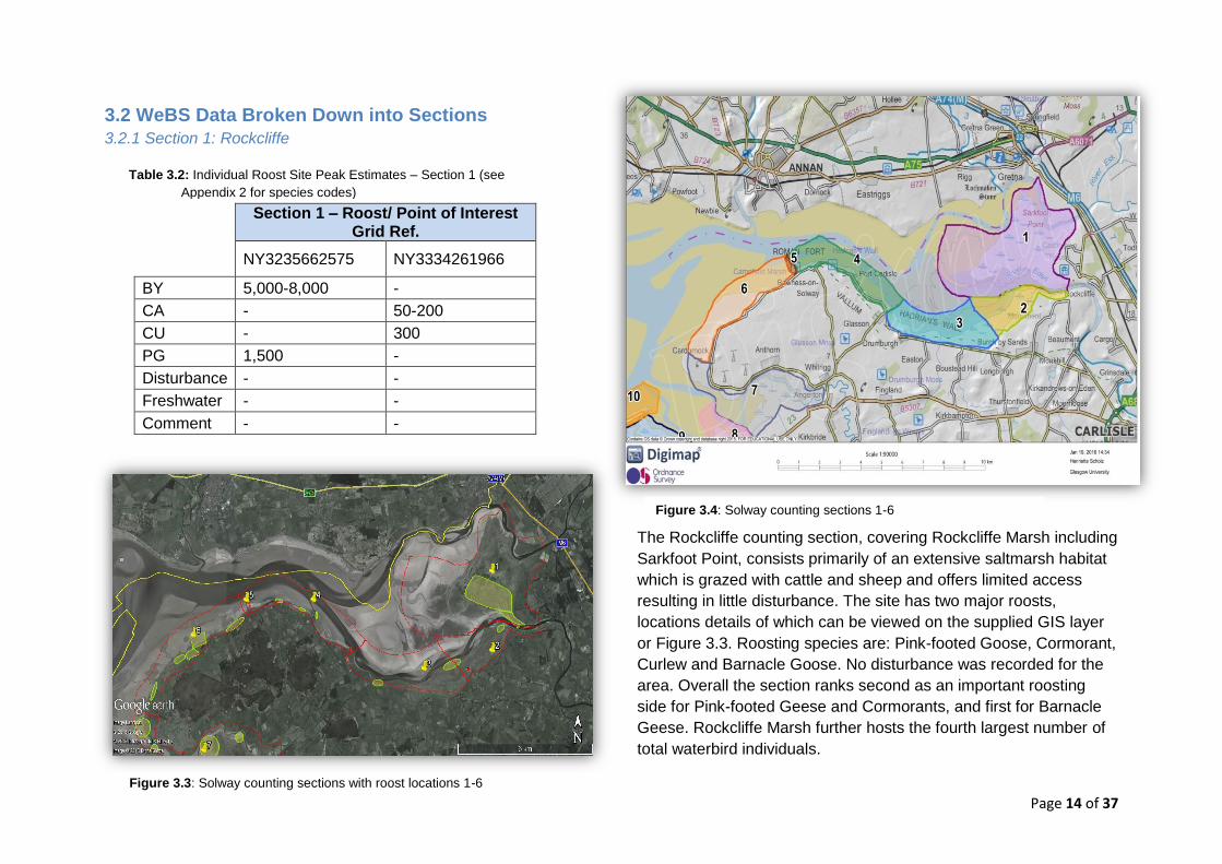
Figure 3.3: Solway counting sections with roost locations 1-6
3.2 WeBS Data Broken Down into Sections
3.2.1 Section 1: Rockcliffe
Section 1 – Roost/ Point of Interest Grid Ref.
NY3235662575 NY3334261966
BY 5,000-8,000 -
CA - 50-200
CU - 300
PG 1,500 -
Disturbance - -
Freshwater - -
Comment - -
The Rockcliffe counting section, covering Rockcliffe Marsh including
Sarkfoot Point, consists primarily of an extensive saltmarsh habitat
which is grazed with cattle and sheep and offers limited access
resulting in little disturbance. The site has two major roosts,
locations details of which can be viewed on the supplied GIS layer
or Figure 3.3. Roosting species are: Pink-footed Goose, Cormorant,
Curlew and Barnacle Goose. No disturbance was recorded for the
area. Overall the section ranks second as an important roosting
side for Pink-footed Geese and Cormorants, and first for Barnacle
Geese. Rockcliffe Marsh further hosts the fourth largest number of
total waterbird individuals.
Figure 3.4: Solway counting sections 1-6
Table 3.2: Individual Roost Site Peak Estimates – Section 1 (see
Appendix 2 for species codes)
Page 15 of 37
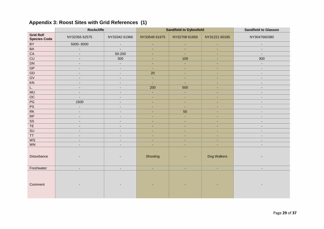
3.2.2 Section 2: Sandsfield to Dykesfield
The Sandsfield to Dykesfield counting section, covering Burgh
Marsh – a wide tract of open satmarsh grazed with cattle and sheep
- has three roosts, locations and details of which can be viewed on
the supplied GIS layer or Figure 3.3. Roosting species are:
Goosander, Curlew, Lapwing and Redshank. This section has the
third lowest total number of roosting birds but the highest numbers
of Lapwing, Curlew and Goosander according to field records. No
species of international importance roost here. Disturbance in the
form of shooting was recorded near the first roost site hosting
Goosander and Lapwing. A second location of disturbance is
marked as a red dot in Figure 3.3 and was described as a popular
site for dog walkers. Even though the site might not be highly
frequented, a single dog can still cause significant disturbance and
result in entire roosts shifting to different grounds.
3.3.3 Section 3: Dykesfield to Glasson
Section 3 – Roost/ Point of Interest Grid Ref.
NY3047660380* NY2721459823
CU 300 50
DN - 600
OC - 100
RK - 40
WN - 300
Disturbance - -
Freshwater - -
Comment - -
The Dykesfield to Glasson counting section covers the remaining
half of Burgh Marsh with a slightly more narrowing are of saltmarsh.
Again, the site is grazed with cattle and sheep and has easy access
from the road which makes it popular with dog walkers etc. Field
WeBS records located two roosts in this site, one of which most
likely overlaps with the final roost recorded in Section 2 (see Figure
3.3). This section is one out of two recorded sites hosting a roost of
Wigeons. Other species roosting here are Oystercatcher, Dunlin,
Curlew and Redshank. No disturbance was noted. Overall this
section ranks low, Rank 14, for total number of individual birds
present.
Section 2 – Roost/ Point of Interest Grid Ref.
NY3354661675
NY3270861659
NY3047660380*
NY3122160185
CU - 100 300 -
GD 20 - - -
L. 200 500 - -
RK - 50 - -
Disturbance Shooting - - Dog Walkers
Freshwater - - - -
Comment - - - -
Table 3.3: Individual Roost Site Peak Estimates – Section 2 (see Appendix 2 for
species codes)
*NY3047660380 appears twice because this roost site stretches across the boundaries of counting sections 2 & 3 – titled Sandfield to Glasson in GIS layer.
Table 3.4: Individual Roost Site Peak Estimates – Section 3 (see
Appendix 2 for species codes)
Page 16 of 37
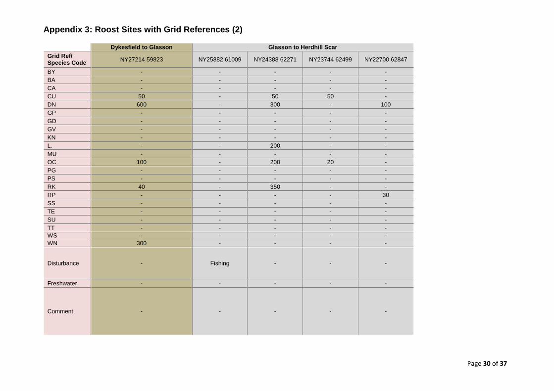
3.3.4 Section 4: Glasson to Herdhill Scar
The Glasson to Herdhill Scar section covers a small area of
narrowing saltmarsh, Westfield Marsh, close to Port Carlisle
including Kirkland Scar. The scar concentrates large numbers of
feeding birds, giving it additional importance. Close to Glasson, the
field records show a strip of coast which is heavily used for shore
fishing at high tide as marked with a red dot in Figure 3.3 close to
the border to Section 3. This results in few roosting birds in this
area. Further towards Herdhill Scar three medium sized roost sites
were recorded. Roosting species are: Oystercatcher, Ringed
Plover, Dunlin, Curlew, Redshank and Lapwing. This section hosts
the largest number of Redshanks within the surveyed Solway area.
3.3.5 Section 5: Herdhill Scar
There are currently no separate field counts for Herdhill Scar,
however, records of counts within the WeBS data base exist.
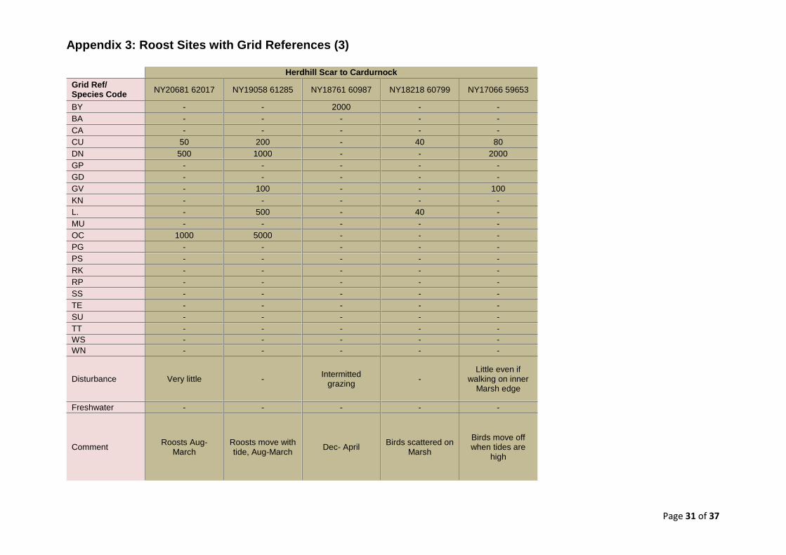
3.3.6 Section 6: Herdhill Scar to Cardurnock
Section 4 – Roost/ Point of Interest Grid Ref.
NY2588261009
NY2438862271
NY2374462499
NY2270062847
CU - 50 50 -
DN - 300 - 100
L. - 200 - -
OC - 200 20 -
RK - 350 - -
RP - - - 30
Disturbance Fishing - - -
Freshwater - - - -
Comment - - - -
Section 6 – Roost/ Point of Interest Grid Ref.
NY2068162017
NY1905861285
NY1876160987
NY1821860799
NY1706659653
BY - - 2000 - -
CU 50 200 - 40 80
DN 500 1,000 - - 2,000
GV - 100 - - 100
L. - 500 - 40 -
OC 1,000 5,000 - - -
Disturbance Very little - Intermitted grazing
-
Little even if walking on inner Marsh edge
Freshwater - - - - -
Comment Roosts Aug-March
Roosts move with tide, Aug-March
Dec- April Birds scattered on Marsh
Birds move off when tides are high
Table 3.5: Individual Roost Site Peak Estimates – Section 4 (see Appendix 2 for
species codes)
Table 3.6: Individual Roost Site Peak Estimates – Section 6 (see Appendix 2 for
species codes)
Page 17 of 37
Figure 3.4: Solway counting sections close up 7-13
The Herdhill Scar to Cardurnock section covers all of Campfield
Marsh and is located right by the RSPB Campfield Marsh Nature
Reserve. The habitat here consists of widening saltmarsh which is
grazed with cattle only. This section has five roosts in total and
ranks second for total number of individual birds. Roosting species
are: Oystercatcher, Dunlin, Curlew, Barnacle Goose, Grey Plover
and Lapwing. The second largest Oystercatcher number is located
within this section alongside the greatest number of roosting Dunlin
which is the same as the GB threshold for this species. One roost
was recorded as experiencing intermittent grazing but overall
disturbance was described as ‘very low’. Further comments were
made on the movement of roosts between seasons and depending
on the tides.
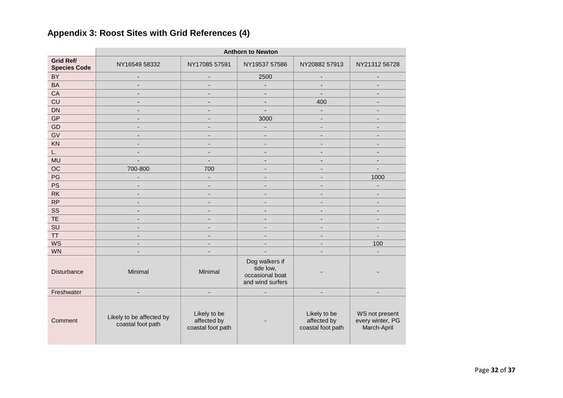
3.3.7 Section 7: Anthorn to Newton
The Anthorn to Newton section includes parts of Cardurnock Marsh
and all of Anthorn Marsh and Newton Marsh, narrow saltmarshes
adjacent to the river Wampool which are grazed with sheep and
cattle. The section has five major roosts, the species present being:
Whooper Swan, Pink-footed Goose, Oystercatcher, Golden Plover,
Curlew and Barnacle Goose. The highest numbers of Golden
Section 7 – Roost/ Point of Interest Grid Ref.
NY1654958332
NY1708557591
NY1953757586
NY2088257913
NY2131256728
BY - - 2,500 - -
CU - - - 400 -
GP - - 3,000 - -
OC 700-800 700 - - -
PG
1,000
Disturbance Minimal Minimal
Dog walkers if tide low, occasional boat and wind surfers
- -
Freshwater - - - - -
Comment
Likely to be affected by coastal foot path
Likely to be affected by coastal foot path
-
Likely to be affected by coastal foot path
WS not Yes every winter, PG March-April
Table 3.7: Individual Roost Site Peak Estimates – Section 7 (see Appendix 2 for
species codes)
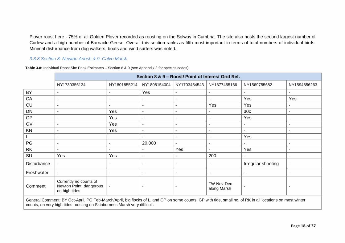
Page 18 of 37
Plover roost here - 75% of all Golden Plover recorded as roosting on the Solway in Cumbria. The site also hosts the second largest number of
Curlew and a high number of Barnacle Geese. Overall this section ranks as fifth most important in terms of total numbers of individual birds.
Minimal disturbance from dog walkers, boats and wind surfers was noted.
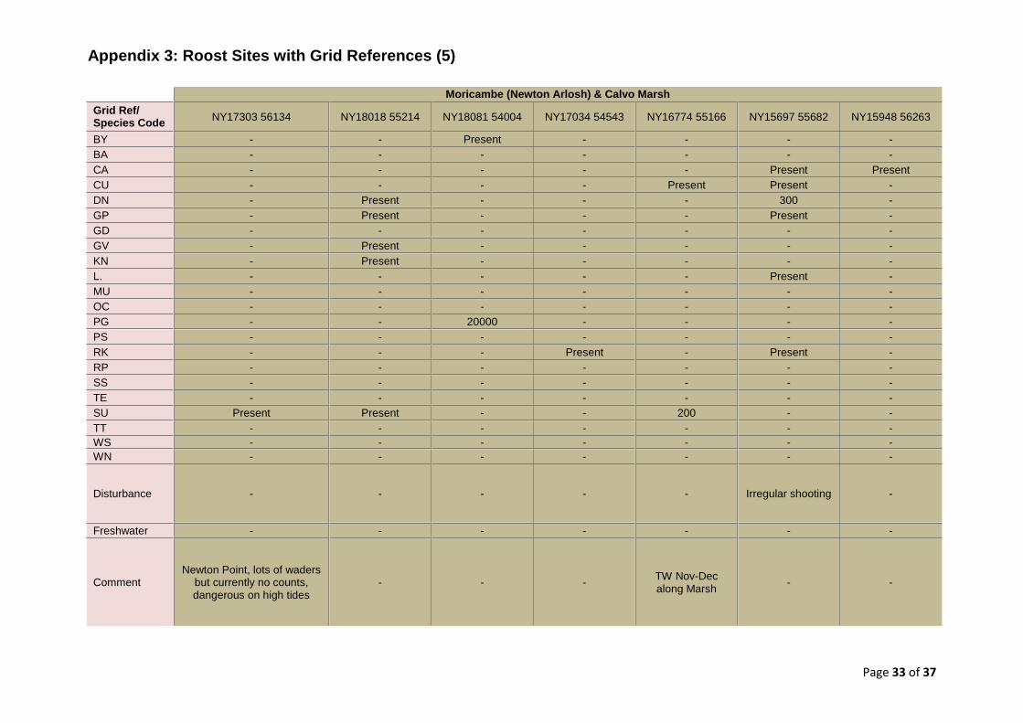
3.3.8 Section 8: Newton Arlosh & 9. Calvo Marsh
Section 8 & 9 – Roost/ Point of Interest Grid Ref.
NY1730356134 NY1801855214 NY1808154004 NY1703454543 NY1677455166 NY1569755682 NY1594856263
BY - - Yes - - - -
CA - - - - - Yes Yes
CU - - - - Yes Yes -
DN - Yes - - - 300 -
GP - Yes - - - Yes -
GV - Yes - - - - -
KN - Yes - - - - -
L. - - - - - Yes -
PG - - 20,000 - - - -
RK - - - Yes - Yes -
SU Yes Yes - - 200 - -
Disturbance - - - - - Irregular shooting -
Freshwater - - - - - - -
Comment Currently no counts of Newton Point, dangerous on high tides
- - - TW Nov-Dec along Marsh
- -
General Comment: BY Oct-April, PG Feb-March/April, big flocks of L. and GP on some counts, GP with tide, small no. of RK in all locations on most winter counts, on very high tides roosting on Skinburness Marsh very difficult.
Table 3.8: Individual Roost Site Peak Estimates – Section 8 & 9 (see Appendix 2 for species codes)
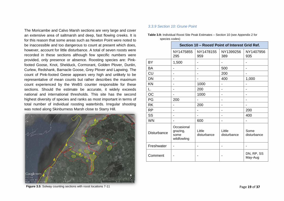
Page 19 of 37 Figure 3.5: Solway counting sections with roost locations 7-11
The Moricambe and Calvo Marsh sections are very large and cover
an extensive area of saltmarsh and deep, fast flowing creeks. It is
for this reason that some areas such as Newton Point were noted to
be inaccessible and too dangerous to count at present which does,
however, account for little disturbance. A total of seven roosts were
recorded in these sections although few specific numbers were
provided, only presence or absence. Roosting species are: Pink-
footed Goose, Knot, Shelduck, Cormorant, Golden Plover, Dunlin,
Curlew, Redshank, Barnacle Goose, Grey Plover and Lapwing. The
count of Pink-footed Geese appears very high and unlikely to be
representative of mean counts but rather describes the maximum
count experienced by the WeBS counter responsible for these
sections. Should the estimate be accurate, it widely exceeds
national and international thresholds. This site has the second
highest diversity of species and ranks as most important in terms of
total number of individual roosting waterbirds. Irregular shooting
was noted along Skinburness Marsh close to Starry Hill.
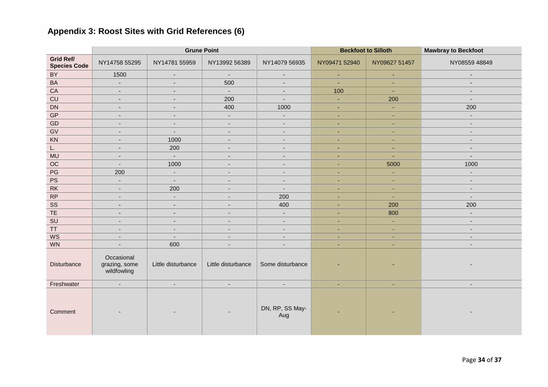
3.3.9 Section 10: Grune Point
Section 10 – Roost/ Point of Interest Grid Ref.
NY1475855295
NY1478155959
NY1399256389
NY1407956935
BY 1,500 - - -
BA - - 500 -
CU - - 200 -
DN - - 400 1,000
KN - 1000 - -
L. - 200 - -
OC - 1000 - -
PG 200 - - -
RK - 200 - -
RP - - - 200
SS - - - 400
WN - 600 - -
Disturbance
Occasional grazing, some wildfowling
Little disturbance
Little disturbance
Some disturbance
Freshwater - - - -
Comment - - - DN, RP, SS May-Aug
Table 3.9: Individual Roost Site Peak Estimates – Section 10 (see Appendix 2 for
species codes)
Page 20 of 37 Figure 3.6: Solway counting sections with roost locations 12-13
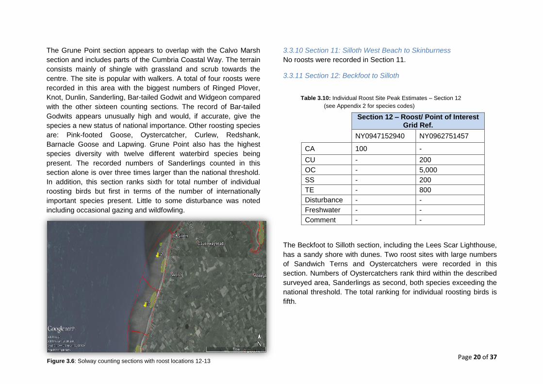
The Grune Point section appears to overlap with the Calvo Marsh
section and includes parts of the Cumbria Coastal Way. The terrain
consists mainly of shingle with grassland and scrub towards the
centre. The site is popular with walkers. A total of four roosts were
recorded in this area with the biggest numbers of Ringed Plover,
Knot, Dunlin, Sanderling, Bar-tailed Godwit and Widgeon compared
with the other sixteen counting sections. The record of Bar-tailed
Godwits appears unusually high and would, if accurate, give the
species a new status of national importance. Other roosting species
are: Pink-footed Goose, Oystercatcher, Curlew, Redshank,
Barnacle Goose and Lapwing. Grune Point also has the highest
species diversity with twelve different waterbird species being
present. The recorded numbers of Sanderlings counted in this
section alone is over three times larger than the national threshold.
In addition, this section ranks sixth for total number of individual
roosting birds but first in terms of the number of internationally
important species present. Little to some disturbance was noted
including occasional gazing and wildfowling.
3.3.10 Section 11: Silloth West Beach to Skinburness
No roosts were recorded in Section 11.
3.3.11 Section 12: Beckfoot to Silloth
Section 12 – Roost/ Point of Interest Grid Ref.
NY0947152940 NY0962751457
CA 100 -
CU - 200
OC - 5,000
SS - 200
TE - 800
Disturbance - -
Freshwater - -
Comment - -
The Beckfoot to Silloth section, including the Lees Scar Lighthouse,
has a sandy shore with dunes. Two roost sites with large numbers
of Sandwich Terns and Oystercatchers were recorded in this
section. Numbers of Oystercatchers rank third within the described
surveyed area, Sanderlings as second, both species exceeding the
national threshold. The total ranking for individual roosting birds is
fifth.
Table 3.10: Individual Roost Site Peak Estimates – Section 12 (see
Appendix 2 for species codes)
Table 3.10: Individual Roost Site Peak Estimates – Section 12
(see Appendix 2 for species codes)
Page 21 of 37
3.3.12 Section 13: Mawbray to Beckfoot
Section 13 – Roost/ Point of Interest Grid Ref
NY0855948849
DN 200
OC 1000
SS 200
Disturbance -
Freshwater -
Comment -
The Mawbray to Beckfoot section is adjacent to Mawbray Bank - an
area with a sandy shore and dunes - and has one roost site
consisting of one species of international and two of national
importance; Oystercatchers, Sanderling and Dunlin, all three in
comparatively low numbers. Generally, this section has the fifth
lowest number of roosting birds. The roosts’ locations are illustrated
in Figure 3.6.
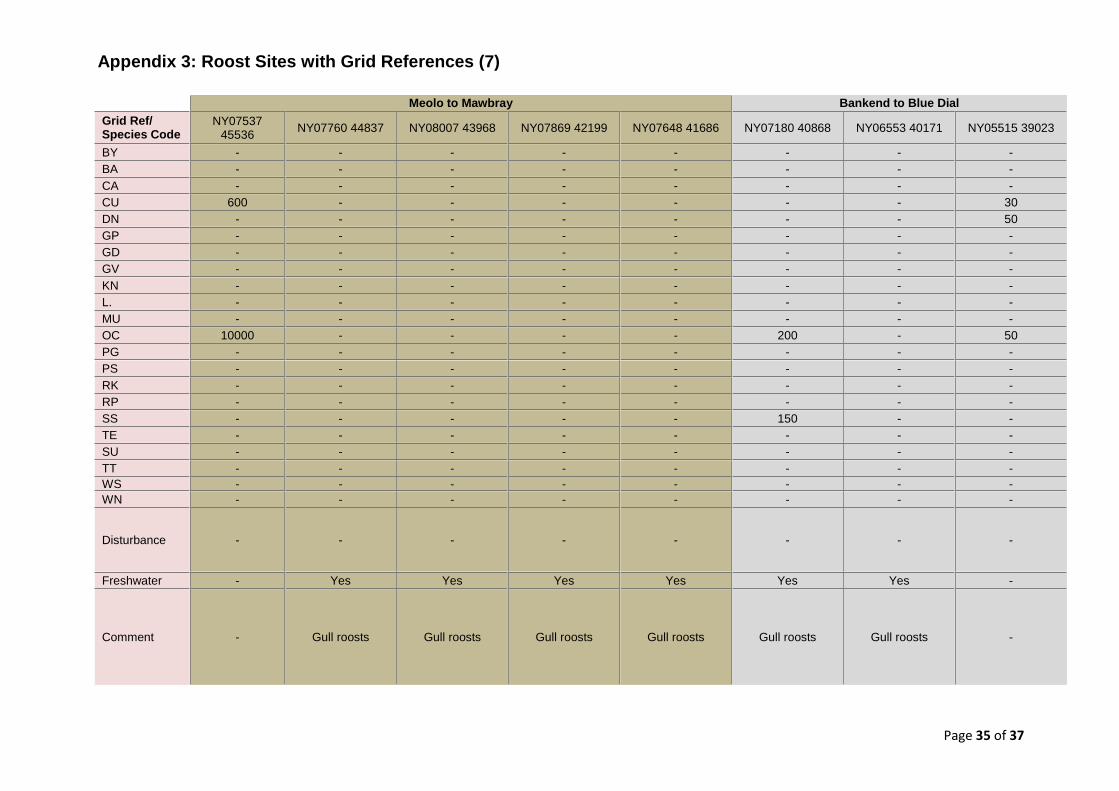
3.3.13 Section 14: Meolo to Mawbray
Section 14 – Roost/ Point of Interest Grid Ref
NY07537 45536
NY07760 44837
NY08007 43968
NY07869 42199
NY07648 41686
CU 600 - - - -
OC 10000 - - - -
Disturbance - - - - -
Freshwater - Yes Yes Yes Yes
Comment - Gull roosts
Gull roosts
Gull roosts
Gull roosts
The Meolo to Mawbray section includes only one waterbird roost
but four gull roosts which are recorded on a voluntary basis through
the WeBS counters. This site – consisting of a sandy shore with
offshore scars – lies outside the current SPA boundary but has the
largest roost of Oystercatchers and Curlew in the South Solway.
Although this section only hosts two waterbird species - recorded
and identified to be present in significant numbers - it ranks third in
total numbers. The gull roosts were noted to be in relation to
freshwater outflows providing bathing and drinking opportunities. No
disturbance was recorded.
Table 3.11: Individual Roost Site Peak Estimates – Section 13
(see Appendix 2 for species codes) Table 3.12: Individual Roost Site Peak Estimates – Section 14 (see Appendix 2
for species codes)
Page 22 of 37
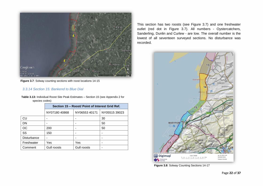
Figure 3.7: Solway counting sections with roost locations 14-15
Figure 3.8: Solway Counting Sections 14-17
3.3.14 Section 15: Bankend to Blue Dial
Section 15 – Roost/ Point of Interest Grid Ref.
NY07180 40868 NY06553 40171 NY05515 39023
CU - - 30
DN - - 50
OC 200 - 50
SS 150 - -
Disturbance - - -
Freshwater Yes Yes -
Comment Gull roosts Gull roosts -
This section has two roosts (see Figure 3.7) and one freshwater
outlet (red dot in Figure 3.7). All numbers - Oystercatchers,
Sanderling, Dunlin and Curlew - are low. The overall number is the
lowest of all seventeen surveyed sections. No disturbance was
recorded.
Table 3.13: Individual Roost Site Peak Estimates – Section 15 (see Appendix 2 for
species codes)
Page 23 of 37
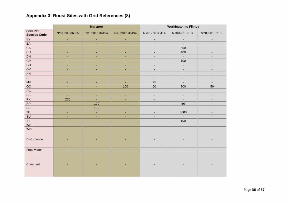
3.3.15 Section 16: Maryport
Section 16 – Roost/ Point of Interest Grid Ref.
NY0320336895 NY0281536494 NY0281536494
OC - - 100
RK 200 - -
RP - 100 -
TE - 100 -
Disturbance - - -
Freshwater - - -
Comment - - -
This section in the outer Solway is less sheltered and thus attracts
fewer birds. Three roosts with low numbers of Oystercatcher,
Ringed Plover, Sanderling and Redshank, two of which are located
by the harbour, were noted here. No additional disturbance was
recorded.
3.3.16 Section 17: Workington to Flimby
Section 17 – Roost/ Point of Interest Grid Ref.
NY0176633414 NY0028132139 NY0028132139
CA - 500 -
CU - 400 -
GP - 100 -
MU 25 - -
OC 50 200 50
RP - 50 -
TE - 3000 -
TT - 100 -
Disturbance - - -
Freshwater - - -
Comment - - -
The Workington to Flimby section, between the two towns, hosts
eight different species including the largest Turnstone, the second
biggest Golden Plover and the most important Cormorant,
Sandwich Tern and Mediterranean Gull records. In total, the site
ranks eighth for number of individuals.
Table 3.14: Individual Roost Site Peak Estimates – Section 16 (see Appendix 2
for species codes)
Table 3.15: Individual Roost Site Peak Estimates – Section 17 (see Appendix
2 for species codes)
Table 3.14: Individual Roost Site Peak Estimates – Section 16 (see Appendix
2 for species codes)
Page 24 of 37
Figure 16: Solway counting sections with roost locations 16-17
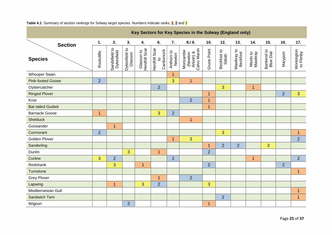
4. Conclusion and Recommendations
Counting sections vary strongly in the presence of roost
sites. Prioritisation and ranking according to different criteria
was thus possible (see Table 4.1 for species ranking
summary and Appendix 1 for the differentiation of various
categories).
A total of 43 major roost sites are present along the
Solway’s South shore.
The Cumbrian side of the Solway is a crucial habitat for
roosting waterbirds of national and international importance.
Counting sections vary strongly in size and area covered. It
is recommended to divide the counting responsibility of
sections 8. and 9., which also appear to be major avian
hotspots, between two counters in the future.
Herdhill Scar, as an individual section, does currently not
have a WeBS counter. It is recommended to clarify the
coverage of this section.
There is some inconsistency in the division of sections
between field counts and official WeBS data records.
There is no ongoing evidence from this study about the
impact of disturbance on roosts present in the Solway.
However, notably, even little disturbance can have major
impacts on roosting waterbirds which critically highlights the
need for further work. Overall, a correlation between
undisturbed stretches of coast and high numbers of birds
present was noted.
Sections along the inner, more sheltered part of the Solway
seemed to host a higher number of waterbird roosts.
No major knowledge gaps were identified.
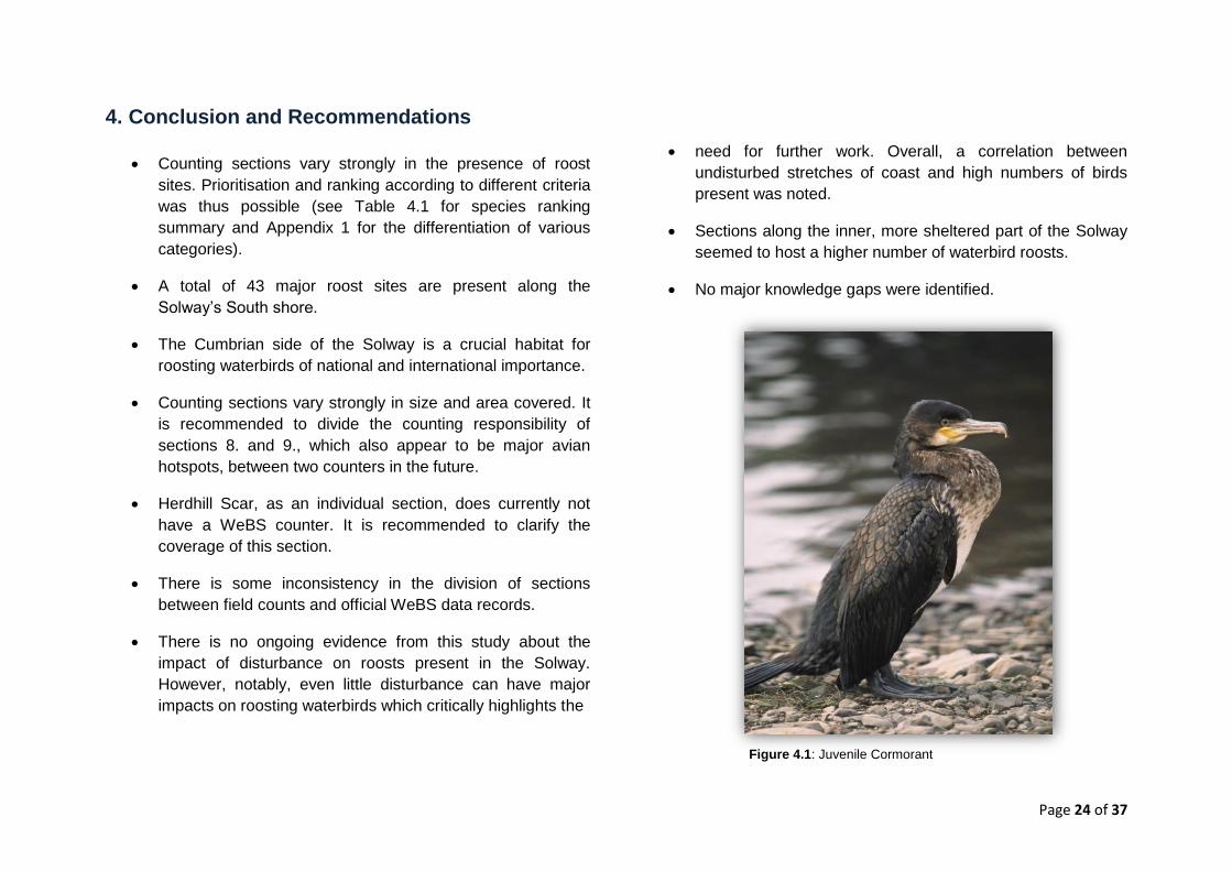
Figure 4.1: Juvenile Cormorant
Page 25 of 37
Section
Species
1. 2. 3. 4. 6. 7. 8./ 9. 10. 12. 13. 14. 15. 16. 17.
Rockclif
fe
San
dsfie
ld t
o
Dykesfield
Dykesfield
to
Gla
sson
Gla
sson to
Herd
hill
Scar
Herd
hill
Scar
to
Card
urn
ock
Anth
orn
to
New
ton
Moricam
be
(New
ton
Arlosh)
&
Calv
o M
ars
h
Gru
ne P
oin
t
Beckfo
ot
to
Sill
oth
Maw
bra
y t
o
Beckfo
ot
Meo
lo t
o
Maw
bra
y
Banke
nd t
o
Blu
e D
ial
Mary
port
Work
ingto
n
to F
limby
Whooper Swan 1
Pink-footed Goose 2 3 1
Oystercatcher 2 3 1
Ringed Plover 1 2 3
Knot 2 1
Bar-tailed Godwit 1
Barnacle Goose 1 3 2
Shelduck 1
Goosander 1
Cormorant 2 3 1
Golden Plover 1 3 2
Sanderling 1 2 2 3
Dunlin 3 1 2
Curlew 3 2 2 1 2
Redshank 3 1 2 2
Turnstone 1
Grey Plover 1 2
Lapwing 1 3 2 3
Mediterranean Gull 1
Sandwich Tern 2 1
Wigeon 2 1
Key Sectors for Key Species in the Solway (England only)
Table 4.1: Summary of section rankings for Solway target species. Numbers indicate ranks; 1, 2 and 3
Page 26 of 37
5. References 1) Wetlands International (2012). Waterbird Population Estimates,
Fifth Edition - Summary Report. Wageningen, The Netherlands:
Wetlands International.
2) UNESCO (1994). Convention on Wetlands of International
Importance especially as Waterfowl Habitat. Paris: UNESCO.
3) Council Directive 2009/147/EC of 30 November 2009 on the
conservation of wild birds (Bird Directive).
4) Holt, C.A., Austin, G.E., Calbrade, N.A., Mellan, H.J., Hearn,
R.D., Stroud, D.A., Wotton, S.R., Musgrove, A.J. 2015.
Waterbirds in the UK 2013/14: The Wetland Bird Survey.
Thetford: BTO/RSPB/JNCC.
5) Burger, J. (1981). The effect of human activity on birds at a
coastal bay. Biological Conservation, 21(3), 231-241.
6) Kirkby, J.S., Clee, C. & Seager, V. (1993). Impact and extent of
recreational disturbance to wader roosts on the Dee estuary:
some preliminary results. Wader Study Group Bulletin, 68, 53-
58.
7) JNCC (2005). Information Sheet on Ramsar Wetlands (RIS) –
Upper Solway Flats and Marshes.Gland, Switzerland: Ramsar
Secretariat.
8) RSPB (2015). About Campfield Marsh. Online at:
http://www.rspb.org.uk/discoverandenjoynature/seenature/reser
ves/guide/c/campfieldmarsh/about.aspx [accessed 28/10/15].
9) SFP (2015). Solway Firth Partnership Business Plan 2015-
2018. Scotland: SFP.
10) JNCC (2015). Solway Firth. Online at:
http://jncc.defra.gov.uk/ProtectedSites/SACselection/sac.asp?E
UCode=UK0013025 [accessed 15/02/16].
11) JNCC (2006). Upper Solway Flats and Marshes – Standard
Natura 2000 Data Form. Online at:
http://jncc.defra.gov.uk/pdf/SPA/UK9005012.pdf [accessed
04/02/15].
12) Marine and Coastal Access Act 2009. (c.23). UK: The
Stationary Office.
13) Rogers, D.I. (2003). High-tide roost choice by coastal waders.
Wader Study Bulletin, 100, 73-79.
14) Bibby CJ, Burgess ND, Hill DA & Mustoe S. 2000. Bird Census
Techniques. Second Edition. Academic Press, London.
15) SNH & JNCC (2014). The suit of Scottish marine dSPAs.
Available at: http://www.snh.gov.uk/docs/A1350044.pdf
[accessed 21 April 2016].
Further Information: International waterbird population estimates:
www.wpe.wetlands.org
Bird Life International Species information:
www.birdlife.org
BTO WeBS methodology:
www.bto.org/volunteer-surveys/web
Page 27 of 37
6. Appendices
Appendix 1: Site Rankings
Ranking by Overall Number of Individual Waterbirds
1. Moricambe (Newton Arlosh) & Calvo Marsh 2. Herdhill Scar to Cardurnock 3. Meolo to Mawbray 4. Rockcliffe 5. Anthorn to Newton
Ranking by Overall Species Diversity
1. Grune Point 2. Moricambe (Newton Arlosh) & Calvo Marsh 3. Workington to Flimby
4./5./6. Glasson to Herdhill Scar 4./5./6. Herdhill Scar to Cardurnock 4./5./6. Anthorn to Newton
Ranking by Number of Oystercatchers
1. Meolo to Mawbray 2. Herdhill Scar to Cardurnock 3. Beckfoot to Silloth
4./ 5. Grune Point 4./ 5. Mawbray to Beckfoot
Ranking by Number of Pink-footed Geese
1. Moricambe (Newton Arlosh) & Calvo Marsh
2. Rockcliffe
3. Anthorn to Newton
4. Grune Point
Ranking by Number of Barnacle Geese (Svalbard)
1. Rockcliffe
2. Anthorn to Newton
3. Herdhill Scar to Cardurnock
Ranking by Recorded Disturbance in Field Counts
1. Grune Point
2. Sandsfield to Dykesfield
3. Anthorn to Newton
Recorded was ‘Some’ and ‘Little’ Disturbance. Site ranked as 1.
experience the greatest disturbance.

Page 28 of 37
Appendix 2: BTO Species Codes for Target Species
BTO Species Code Species’ Common Name
BY Barnacle Goose
BA Bar-tailed Godwit
CA Cormorant
CU Curlew
DN Dunlin
GP Golden Plover
GD Goosander
GV Grey Plover
KN Knot
L. Lapwing
MU Mediterranean Gull
OC Oystercatcher
PG Pink-footed Goose
RK Redshank
RP Ringed Plover
SS Sanderling
TE Sandwich Tern
SU Shelduck
TT Turnstone
WS Whooper Swan
WN Wigeon
Page 29 of 37
Rockcliffe Sandfield to Dykesfield Sandfield to Glasson
Grid Ref/ Species Code
NY32356 62575 NY33342 61966 NY33546 61675 NY32708 61659 NY31221 60185 NY3047660380
BY 5000- 8000 - - - - -
BA - - - - - -
CA - 50-200 - - - -
CU - 300 - 100 - 300
DN - - - - - -
GP - - - - - -
GD - - 20 - - -
GV - - - - - -
KN - - - - - -
L. - - 200 500 - -
MU - - - - - -
OC - - - - - -
PG 1500 - - - - -
PS - - - - - -
RK - - - 50 - -
RP - - - - - -
SS - - - - - -
TE - - - - - -
SU - - - - - -
TT - - - - - -
WS - - - - - -
WN - - - - - -
Disturbance - - Shooting - Dog Walkers -
Freshwater - - - - - -
Comment - - - - - -
Appendix 3: Roost Sites with Grid References
(1)
Page 30 of 37
Dykesfield to Glasson Glasson to Herdhill Scar
Grid Ref/ Species Code
NY27214 59823 NY25882 61009 NY24388 62271 NY23744 62499 NY22700 62847
BY - - - - -
BA - - - - -
CA - - - - -
CU 50 - 50 50 -
DN 600 - 300 - 100
GP - - - - -
GD - - - - -
GV - - - - -
KN - - - - -
L. - - 200 - -
MU - - - - -
OC 100 - 200 20 -
PG - - - - -
PS - - - - -
RK 40 - 350 - -
RP - - - - 30
SS - - - - -
TE - - - - -
SU - - - - -
TT - - - - -
WS - - - - -
WN 300 - - - -
Disturbance - Fishing - - -
Freshwater - - - - -
Comment - - - - -
Appendix 3: Roost Sites with Grid References (2)
Page 31 of 37
Herdhill Scar to Cardurnock
Grid Ref/ Species Code
NY20681 62017 NY19058 61285 NY18761 60987 NY18218 60799 NY17066 59653
BY - - 2000 - -
BA - - - - -
CA - - - - -
CU 50 200 - 40 80
DN 500 1000 - - 2000
GP - - - - -
GD - - - - -
GV - 100 - - 100
KN - - - - -
L. - 500 - 40 -
MU - - - - -
OC 1000 5000 - - -
PG - - - - -
PS - - - - -
RK - - - - -
RP - - - - -
SS - - - - -
TE - - - - -
SU - - - - -
TT - - - - -
WS - - - - -
WN - - - - -
Disturbance Very little - Intermitted
grazing -
Little even if walking on inner
Marsh edge
Freshwater - - - - -
Comment Roosts Aug-
March Roosts move with tide, Aug-March
Dec- April Birds scattered on
Marsh
Birds move off when tides are
high
Appendix 3: Roost Sites with Grid References (3)
Page 32 of 37
Anthorn to Newton
Grid Ref/ Species Code
NY16549 58332 NY17085 57591 NY19537 57586 NY20882 57913 NY21312 56728
BY - - 2500 - -
BA - - - - -
CA - - - - -
CU - - - 400 -
DN - - - - -
GP - - 3000 - -
GD - - - - -
GV - - - - -
KN - - - - -
L. - - - - -
MU - - - - -
OC 700-800 700 - - -
PG - - - - 1000
PS - - - - -
RK - - - - -
RP - - - - -
SS - - - - -
TE - - - - -
SU - - - - -
TT - - - - -
WS - - - - 100
WN - - - - -
Disturbance Minimal Minimal
Dog walkers if tide low,
occasional boat and wind surfers
- -
Freshwater - - - - -
Comment Likely to be affected by
coastal foot path
Likely to be affected by
coastal foot path -
Likely to be affected by
coastal foot path
WS not present every winter, PG
March-April
Appendix 3: Roost Sites with Grid References (4)
Page 33 of 37
Moricambe (Newton Arlosh) & Calvo Marsh
Grid Ref/ Species Code
NY17303 56134 NY18018 55214 NY18081 54004 NY17034 54543 NY16774 55166 NY15697 55682 NY15948 56263
BY - - Present - - - -
BA - - - - - - -
CA - - - - - Present Present
CU - - - - Present Present -
DN - Present - - - 300 -
GP - Present - - - Present -
GD - - - - - - -
GV - Present - - - - -
KN - Present - - - - -
L. - - - - - Present -
MU - - - - - - -
OC - - - - - - -
PG - - 20000 - - - -
PS - - - - - - -
RK - - - Present - Present -
RP - - - - - - -
SS - - - - - - -
TE - - - - - - -
SU Present Present - - 200 - -
TT - - - - - - -
WS - - - - - - -
WN - - - - - - -
Disturbance - - - - - Irregular shooting -
Freshwater - - - - - - -
Comment Newton Point, lots of waders
but currently no counts, dangerous on high tides
- - - TW Nov-Dec along Marsh
- -
Appendix 3: Roost Sites with Grid References (5)
Page 34 of 37
Grune Point Beckfoot to Silloth Mawbray to Beckfoot
Grid Ref/ Species Code
NY14758 55295 NY14781 55959 NY13992 56389 NY14079 56935 NY09471 52940 NY09627 51457 NY08559 48849
BY 1500 - - - - - -
BA - - 500 - - - -
CA - - - - 100 - -
CU - - 200 - - 200 -
DN - - 400 1000 - - 200
GP - - - - - - -
GD - - - - - - -
GV - - - - - - -
KN - 1000 - - - - -
L. - 200 - - - - -
MU - - - - - - -
OC - 1000 - - - 5000 1000
PG 200 - - - - - -
PS - - - - - - -
RK - 200 - - - - -
RP - - - 200 - - -
SS - - - 400 - 200 200
TE - - - - - 800 -
SU - - - - - - -
TT - - - - - - -
WS - - - - - - -
WN - 600 - - - - -
Disturbance Occasional
grazing, some wildfowling
Little disturbance Little disturbance Some disturbance - - -
Freshwater - - - - - - -
Comment - - - DN, RP, SS May-
Aug - - -
Appendix 3: Roost Sites with Grid References (6)
Page 35 of 37
Meolo to Mawbray Bankend to Blue Dial
Grid Ref/ Species Code
NY07537 45536
NY07760 44837 NY08007 43968 NY07869 42199 NY07648 41686 NY07180 40868 NY06553 40171 NY05515 39023
BY - - - - - - - -
BA - - - - - - - -
CA - - - - - - - -
CU 600 - - - - - - 30
DN - - - - - - - 50
GP - - - - - - - -
GD - - - - - - - -
GV - - - - - - - -
KN - - - - - - - -
L. - - - - - - - -
MU - - - - - - - -
OC 10000 - - - - 200 - 50
PG - - - - - - - -
PS - - - - - - - -
RK - - - - - - - -
RP - - - - - - - -
SS - - - - - 150 - -
TE - - - - - - - -
SU - - - - - - - -
TT - - - - - - - -
WS - - - - - - - -
WN - - - - - - - -
Disturbance - - - - - - - -
Freshwater - Yes Yes Yes Yes Yes Yes -
Comment - Gull roosts Gull roosts Gull roosts Gull roosts Gull roosts Gull roosts -
Appendix 3: Roost Sites with Grid References (7)
Page 36 of 37
Maryport Workington to Flimby
Grid Ref/ Species Code
NY03203 36895 NY02815 36494 NY02815 36494 NY01766 33414 NY00281 32139 NY00281 32139
BY - - - - - -
BA - - - - - -
CA - - - - 500 -
CU - - - - 400 -
DN - - - - - -
GP - - - - 100 -
GD - - - - - -
GV - - - - - -
KN - - - - - -
L. - - - - - -
MU - - - 25 - -
OC - - 100 50 200 50
PG - - - - - -
PS - - - - - -
RK 200 - - - - -
RP - 100 - - 50 -
SS - 100 - - - -
TE - - - - 3000 -
SU - - - - - -
TT - - - - 100 -
WS - - - - - -
WN - - - - - -
Disturbance - - - - - -
Freshwater - - - - - -
Comment - - - - - -
Appendix 3: Roost Sites with Grid References (8)
Page 37 of 37
CONTACT
Solway Firth Partnership Campbell House The Crichton Dumfries DG1 4UQ 01387 702161 [email protected] www.solwayfirthpartnership.co.uk
The Solway Firth Partnership is a Scottish Company limited by guarantee and without share capital under Company Number SC250012 and a Scottish Charity under Scottish Charity Number SC034376. Registered office: Campbell House, The Crichton, Bankend Road, Dumfries, DG1 4UQ. This study was supported by Natural England and the RSPB.