hesekiel bernando nainggolan* rm iman … bernando nainggolan* rm iman argakoesoemah* indra wahyudi...
TRANSCRIPT
______________________________________________________________________________________________
* PTTEP Malunda Limited** University of Indonesia *** Institute of Technology Bandung
IPA15-G-157
PROCEEDINGS, IDONESIAN PETROLEUM ASSOCIATION Thirty-Ninth Annual Convention & Exhibition, May 2015
STRUCTURAL DESCRIPTION OF ADANG FAULT, MAKASSAR STRAIT, INDONESIA
Hesekiel Bernando Nainggolan* RM Iman Argakoesoemah*
Indra Wahyudi *,** Andry Hidayat*,***
Muhammad Fikry Shahab*
ABSTRACT
The, presence of Adang Fault is critical to the development of overall Neogene depositions in the southern part of North Makassar Basin. It is believed that the fault has been one of the key players to many deepwater depositional sequences toward the north-northeast. Hence, some of the provenances of deepwaters have been interpreted to be derived from Paternoster Platform where Adang Fault located at the northern border separating the platform from the basin to the northeast.
In subsurface, Adang Fault is descriptively defined using seismic lines partially crossing Paternoster Platform. It is a fault zone showing a group of series of relatively smaller branching faults in a very similar strike towards northwest-southeast but have different dip angle and direction forming normal fault splays of the transtensional strike-slip with dextral movement.
The deepwater reservoir depositions within post-Eocene mega-sequence are interpreted as the results of Paternoster Platform uplift and Adang Fault activities. These depositional episodic seems to continue until present day as shown in seismic lines. All fault splays continue to reach the sea floor, however, toward northwest the faults die out consistently with increasing in water depth and quickly covered by Plio-Pleistocene sediments.
It is noted that the erosion in the base of sea floor channels are related to the fault’s activity at the sea floor.
INTRODUCTION
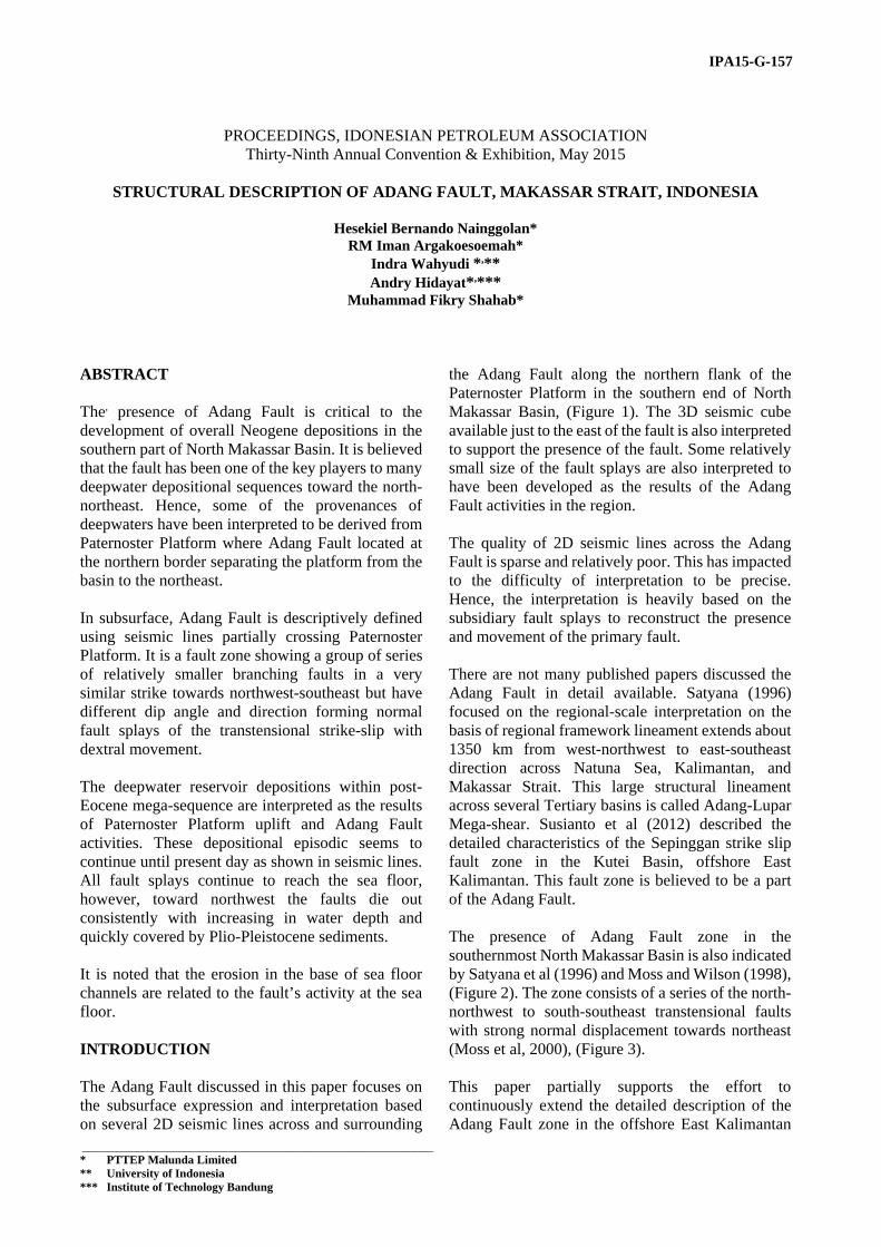
The Adang Fault discussed in this paper focuses on the subsurface expression and interpretation based on several 2D seismic lines across and surrounding
the Adang Fault along the northern flank of the Paternoster Platform in the southern end of North Makassar Basin, (Figure 1). The 3D seismic cube available just to the east of the fault is also interpreted to support the presence of the fault. Some relatively small size of the fault splays are also interpreted to have been developed as the results of the Adang Fault activities in the region.
The quality of 2D seismic lines across the Adang Fault is sparse and relatively poor. This has impacted to the difficulty of interpretation to be precise. Hence, the interpretation is heavily based on the subsidiary fault splays to reconstruct the presence and movement of the primary fault.
There are not many published papers discussed the Adang Fault in detail available. Satyana (1996) focused on the regional-scale interpretation on the basis of regional framework lineament extends about 1350 km from west-northwest to east-southeast direction across Natuna Sea, Kalimantan, and Makassar Strait. This large structural lineament across several Tertiary basins is called Adang-Lupar Mega-shear. Susianto et al (2012) described the detailed characteristics of the Sepinggan strike slip fault zone in the Kutei Basin, offshore East Kalimantan. This fault zone is believed to be a part of the Adang Fault.
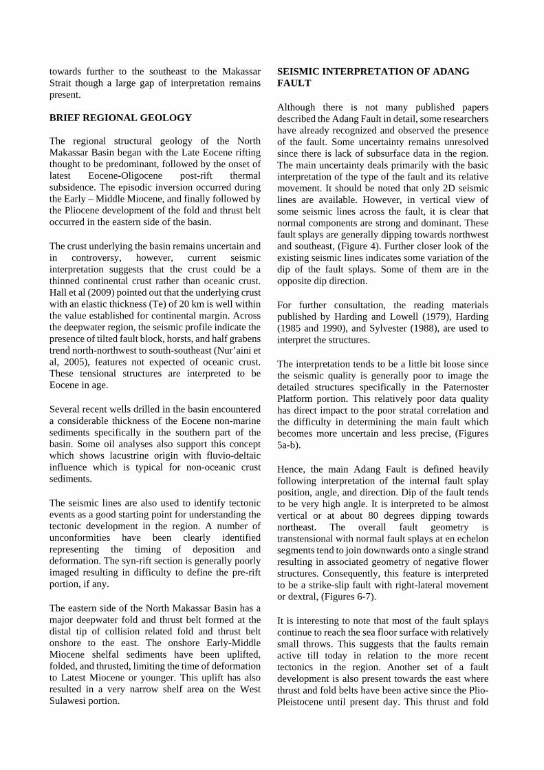
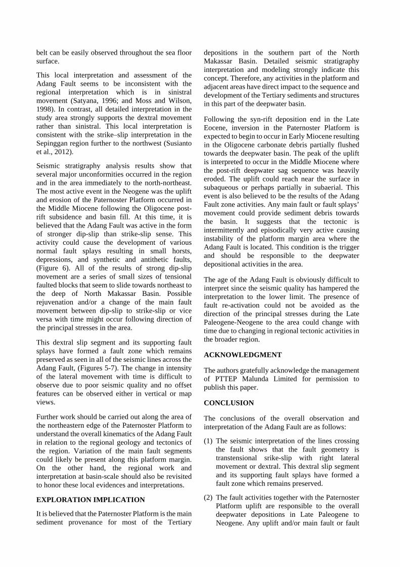
The presence of Adang Fault zone in the southernmost North Makassar Basin is also indicated by Satyana et al (1996) and Moss and Wilson (1998), (Figure 2). The zone consists of a series of the north-northwest to south-southeast transtensional faults with strong normal displacement towards northeast (Moss et al, 2000), (Figure 3).
This paper partially supports the effort to continuously extend the detailed description of the Adang Fault zone in the offshore East Kalimantan
towards further to the southeast to the Makassar Strait though a large gap of interpretation remains present. BRIEF REGIONAL GEOLOGY The regional structural geology of the North Makassar Basin began with the Late Eocene rifting thought to be predominant, followed by the onset of latest Eocene-Oligocene post-rift thermal subsidence. The episodic inversion occurred during the Early – Middle Miocene, and finally followed by the Pliocene development of the fold and thrust belt occurred in the eastern side of the basin. The crust underlying the basin remains uncertain and in controversy, however, current seismic interpretation suggests that the crust could be a thinned continental crust rather than oceanic crust. Hall et al (2009) pointed out that the underlying crust with an elastic thickness (Te) of 20 km is well within the value established for continental margin. Across the deepwater region, the seismic profile indicate the presence of tilted fault block, horsts, and half grabens trend north-northwest to south-southeast (Nur’aini et al, 2005), features not expected of oceanic crust. These tensional structures are interpreted to be Eocene in age. Several recent wells drilled in the basin encountered a considerable thickness of the Eocene non-marine sediments specifically in the southern part of the basin. Some oil analyses also support this concept which shows lacustrine origin with fluvio-deltaic influence which is typical for non-oceanic crust sediments. The seismic lines are also used to identify tectonic events as a good starting point for understanding the tectonic development in the region. A number of unconformities have been clearly identified representing the timing of deposition and deformation. The syn-rift section is generally poorly imaged resulting in difficulty to define the pre-rift portion, if any. The eastern side of the North Makassar Basin has a major deepwater fold and thrust belt formed at the distal tip of collision related fold and thrust belt onshore to the east. The onshore Early-Middle Miocene shelfal sediments have been uplifted, folded, and thrusted, limiting the time of deformation to Latest Miocene or younger. This uplift has also resulted in a very narrow shelf area on the West Sulawesi portion.
SEISMIC INTERPRETATION OF ADANG FAULT Although there is not many published papers described the Adang Fault in detail, some researchers have already recognized and observed the presence of the fault. Some uncertainty remains unresolved since there is lack of subsurface data in the region. The main uncertainty deals primarily with the basic interpretation of the type of the fault and its relative movement. It should be noted that only 2D seismic lines are available. However, in vertical view of some seismic lines across the fault, it is clear that normal components are strong and dominant. These fault splays are generally dipping towards northwest and southeast, (Figure 4). Further closer look of the existing seismic lines indicates some variation of the dip of the fault splays. Some of them are in the opposite dip direction. For further consultation, the reading materials published by Harding and Lowell (1979), Harding (1985 and 1990), and Sylvester (1988), are used to interpret the structures. The interpretation tends to be a little bit loose since the seismic quality is generally poor to image the detailed structures specifically in the Paternoster Platform portion. This relatively poor data quality has direct impact to the poor stratal correlation and the difficulty in determining the main fault which becomes more uncertain and less precise, (Figures 5a-b). Hence, the main Adang Fault is defined heavily following interpretation of the internal fault splay position, angle, and direction. Dip of the fault tends to be very high angle. It is interpreted to be almost vertical or at about 80 degrees dipping towards northeast. The overall fault geometry is transtensional with normal fault splays at en echelon segments tend to join downwards onto a single strand resulting in associated geometry of negative flower structures. Consequently, this feature is interpreted to be a strike-slip fault with right-lateral movement or dextral, (Figures 6-7). It is interesting to note that most of the fault splays continue to reach the sea floor surface with relatively small throws. This suggests that the faults remain active till today in relation to the more recent tectonics in the region. Another set of a fault development is also present towards the east where thrust and fold belts have been active since the Plio-Pleistocene until present day. This thrust and fold
belt can be easily observed throughout the sea floor surface.
This local interpretation and assessment of the Adang Fault seems to be inconsistent with the regional interpretation which is in sinistral movement (Satyana, 1996; and Moss and Wilson, 1998). In contrast, all detailed interpretation in the study area strongly supports the dextral movement rather than sinistral. This local interpretation is consistent with the strike–slip interpretation in the Sepinggan region further to the northwest (Susianto et al., 2012).
Seismic stratigraphy analysis results show that several major unconformities occurred in the region and in the area immediately to the north-northeast. The most active event in the Neogene was the uplift and erosion of the Paternoster Platform occurred in the Middle Miocene following the Oligocene post-rift subsidence and basin fill. At this time, it is believed that the Adang Fault was active in the form of stronger dip-slip than strike-slip sense. This activity could cause the development of various normal fault splays resulting in small horsts, depressions, and synthetic and antithetic faults, (Figure 6). All of the results of strong dip-slip movement are a series of small sizes of tensional faulted blocks that seem to slide towards northeast to the deep of North Makassar Basin. Possible rejuvenation and/or a change of the main fault movement between dip-slip to strike-slip or vice versa with time might occur following direction of the principal stresses in the area.
This dextral slip segment and its supporting fault splays have formed a fault zone which remains preserved as seen in all of the seismic lines across the Adang Fault, (Figures 5-7). The change in intensity of the lateral movement with time is difficult to observe due to poor seismic quality and no offset features can be observed either in vertical or map views.
Further work should be carried out along the area of the northeastern edge of the Paternoster Platform to understand the overall kinematics of the Adang Fault in relation to the regional geology and tectonics of the region. Variation of the main fault segments could likely be present along this platform margin. On the other hand, the regional work and interpretation at basin-scale should also be revisited to honor these local evidences and interpretations.
EXPLORATION IMPLICATION
It is believed that the Paternoster Platform is the main sediment provenance for most of the Tertiary
depositions in the southern part of the North Makassar Basin. Detailed seismic stratigraphy interpretation and modeling strongly indicate this concept. Therefore, any activities in the platform and adjacent areas have direct impact to the sequence and development of the Tertiary sediments and structures in this part of the deepwater basin. Following the syn-rift deposition end in the Late Eocene, inversion in the Paternoster Platform is expected to begin to occur in Early Miocene resulting in the Oligocene carbonate debris partially flushed towards the deepwater basin. The peak of the uplift is interpreted to occur in the Middle Miocene where the post-rift deepwater sag sequence was heavily eroded. The uplift could reach near the surface in subaqueous or perhaps partially in subaerial. This event is also believed to be the results of the Adang Fault zone activities. Any main fault or fault splays’ movement could provide sediment debris towards the basin. It suggests that the tectonic is intermittently and episodically very active causing instability of the platform margin area where the Adang Fault is located. This condition is the trigger and should be responsible to the deepwater depositional activities in the area. The age of the Adang Fault is obviously difficult to interpret since the seismic quality has hampered the interpretation to the lower limit. The presence of fault re-activation could not be avoided as the direction of the principal stresses during the Late Paleogene-Neogene to the area could change with time due to changing in regional tectonic activities in the broader region. ACKNOWLEDGMENT The authors gratefully acknowledge the management of PTTEP Malunda Limited for permission to publish this paper. CONCLUSION The conclusions of the overall observation and interpretation of the Adang Fault are as follows:
(1) The seismic interpretation of the lines crossing the fault shows that the fault geometry is transtensional srike-slip with right lateral movement or dextral. This dextral slip segment and its supporting fault splays have formed a fault zone which remains preserved.
(2) The fault activities together with the Paternoster Platform uplift are responsible to the overall deepwater depositions in Late Paleogene to Neogene. Any uplift and/or main fault or fault
splays’ movement could provide sediment debris towards the deepwater basin.
Further work should be carried out along northeastern edge of the Paternoster Platform to understand the overall kinematics of the Adang Fault in relation to the regional geology and tectonics of the region. Consequently, the regional geology interpretation at basin-scale that has impact to the area should be re-integrated to get the comprehensive results. REFERENCES CITED Harding, T.P., Lowell, J.D., 1979, Structural styles, their plate-tectonic habitats, and hydrocarbon traps in petroleum provinces, The American Association of Petroleum Geologists Bulletin, v.63, n.7, p.1016-1058. Harding, T.P., 1985, Seismic characteristics and identification of negative flower structures, positive flower structures, and positive structural inversion, The American Association of Petroleum Geologists, v.69, n.4, p.582-600. Harding, T.P., 1990, Identification of wrench faults using subsurface structural data: criteria and pitfalls, The American Association of Petroleum Geologists Bulletin, v.74, n.10, p. 1590-1609. Hall, R., Cloke, I.R., Nur’aini, S., Puspita, S.D., Calvert, S.J., Elders, C.F., 2009, The North Makassar Strait: what lies beneath?, Petroleum Geoscience, v.15, p.147-158.
Moss, S.J., Clark, W., Baillie, P., Hermantoro, E., Oemar, S., 2000, Tectono-stratigraphic evolution of the North Makassar Basin, Indonesia. Abstract: AAPG Search and Discovery Article # 90913, AAPG International Conference and Exhibition, Bali, Indonesia. Full paper: 3pp. + 5 fig. Moss, S.J. and Wilson, M.E.J., 1998, Biogeography implications of the Tertiary palaeogeographic evolution of Sulawesi and Borneo, Biogeography and Geological Evolution of SE Asia, Backhuys Publishers, Leiden, The Netherlands, p.133-163. Nur’aini, S., Hall, R.H., and Elders, C.F., 2005, Basement architecture and sedimentary fill of the North Makassar Straits Basin, Proceedings, Indonesian Petroleum Association, 30th Annual Convention and Exhibition, p.483-497. Satyana, A.H., 1996, Adang-Lupar Fault, Kalimantan: controversies and new observations of the Trans-Kalimantan megashear, Proceedings 25th Annual Convention of Indonesian Association of Geologists, p.124-143. Susianto, A., Esomar, E.R., Rahadi, R., and Ardhie, M.N., 2012, The characteristics of the Sepinggan strike-slip fault zone and its role in forming structural traps the Southeast Kutei Basin, Proceedings of Indonesian Petroleum Association, 36th Annual Convention and Exhibition, paper IPA12-G-062, 23 pp. Sylvester, A.G., 1988, Strike-slip faults, Geological Society of America Bulletin, v.100, p.1666-1703.
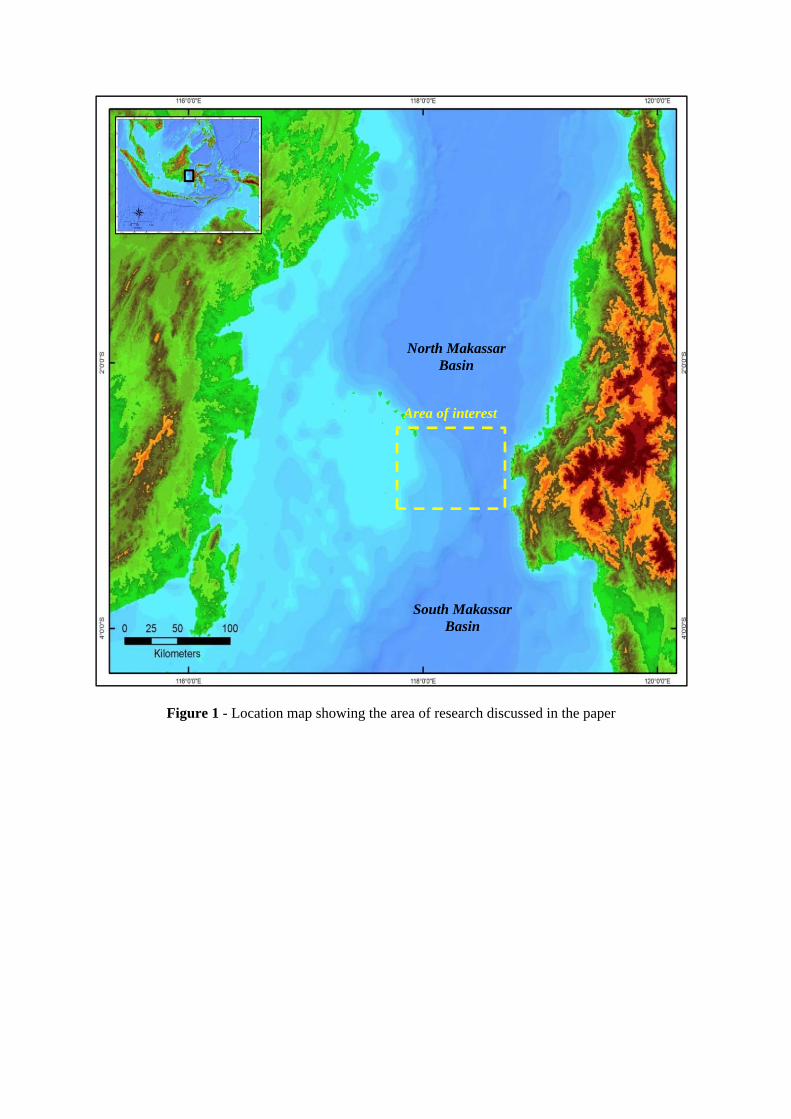
Figure 1 - Location map showing the area of research discussed in the paper
North Makassar Basin
South Makassar Basin
Area of interest
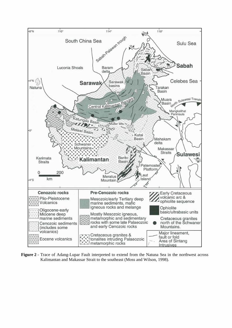
Figure 2 - Trace of Adang-Lupar Fault interpreted to extend from the Natuna Sea in the northwest across Kalimantan and Makassar Strait to the southeast (Moss and Wilson, 1998).
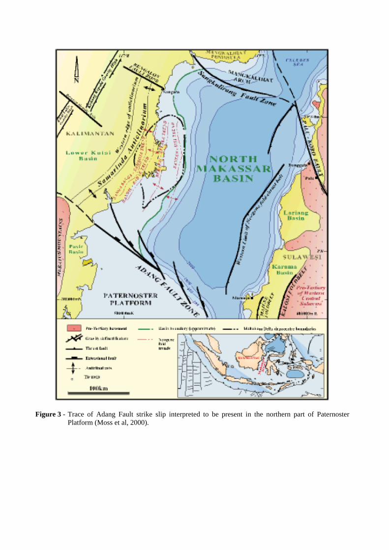
Figure 3 - Trace of Adang Fault strike slip interpreted to be present in the northern part of Paternoster Platform (Moss et al, 2000).
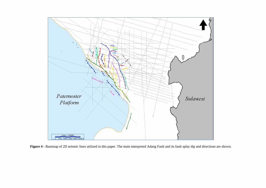
Figure 4 - Basemap of 2D seismic lines utilized in this paper. The main interpreted Adang Fault and its fault splay dip and directions are shown.
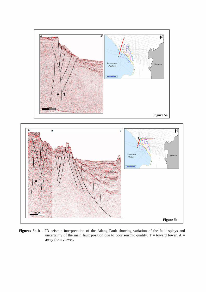
Figures 5a-b - 2D seismic interpretation of the Adang Fault showing variation of the fault splays and
uncertainty of the main fault position due to poor seismic quality. T = toward fewer, A = away from viewer.
T A
T A
Figure 5a
Figure 5b
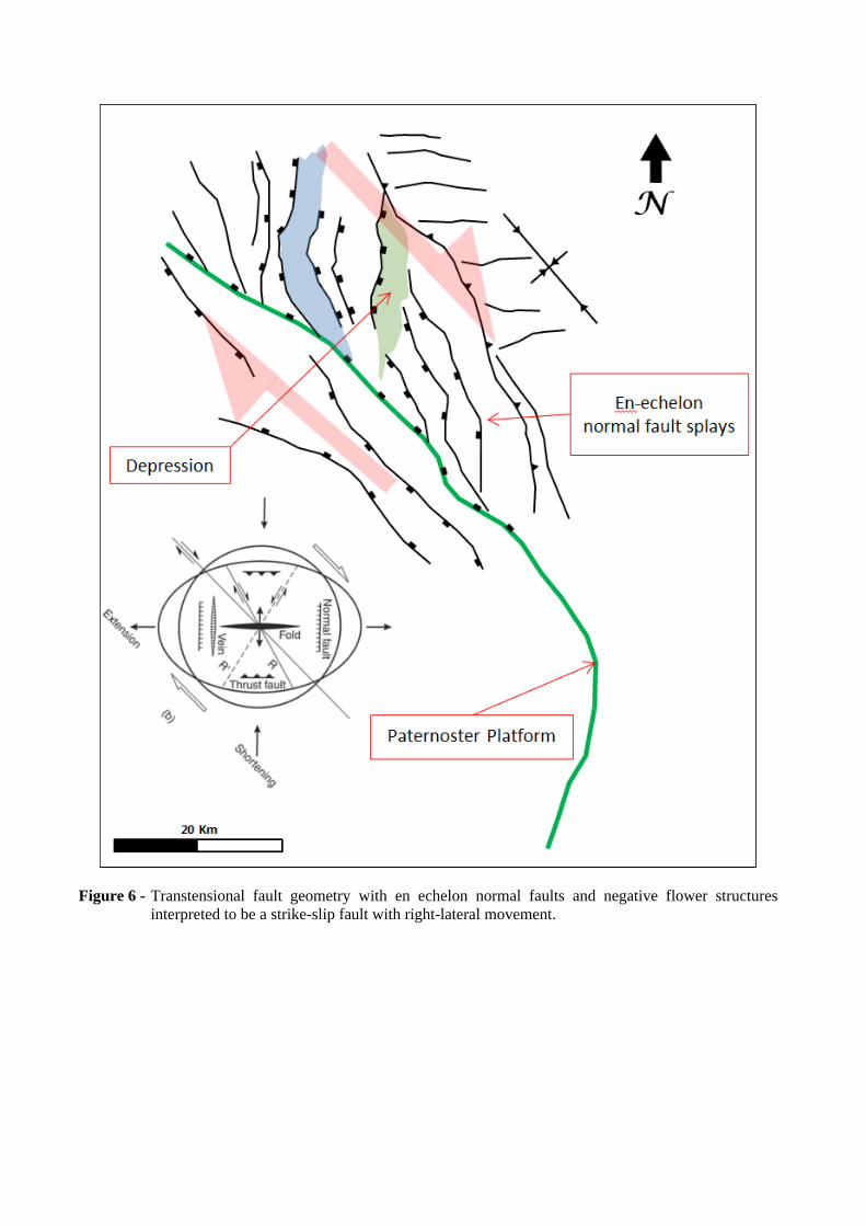
Figure 6 - Transtensional fault geometry with en echelon normal faults and negative flower structures interpreted to be a strike-slip fault with right-lateral movement.
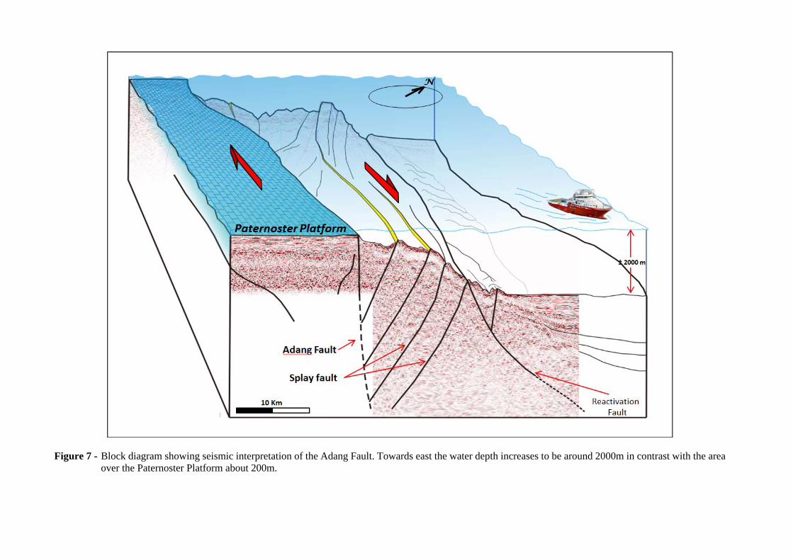
Figure 7 - Block diagram showing seismic interpretation of the Adang Fault. Towards east the water depth increases to be around 2000m in contrast with the area
over the Paternoster Platform about 200m.