herongate conservation area appraisal and management plan
TRANSCRIPT
Herongate
Conservation Area Appraisal and Management Plan

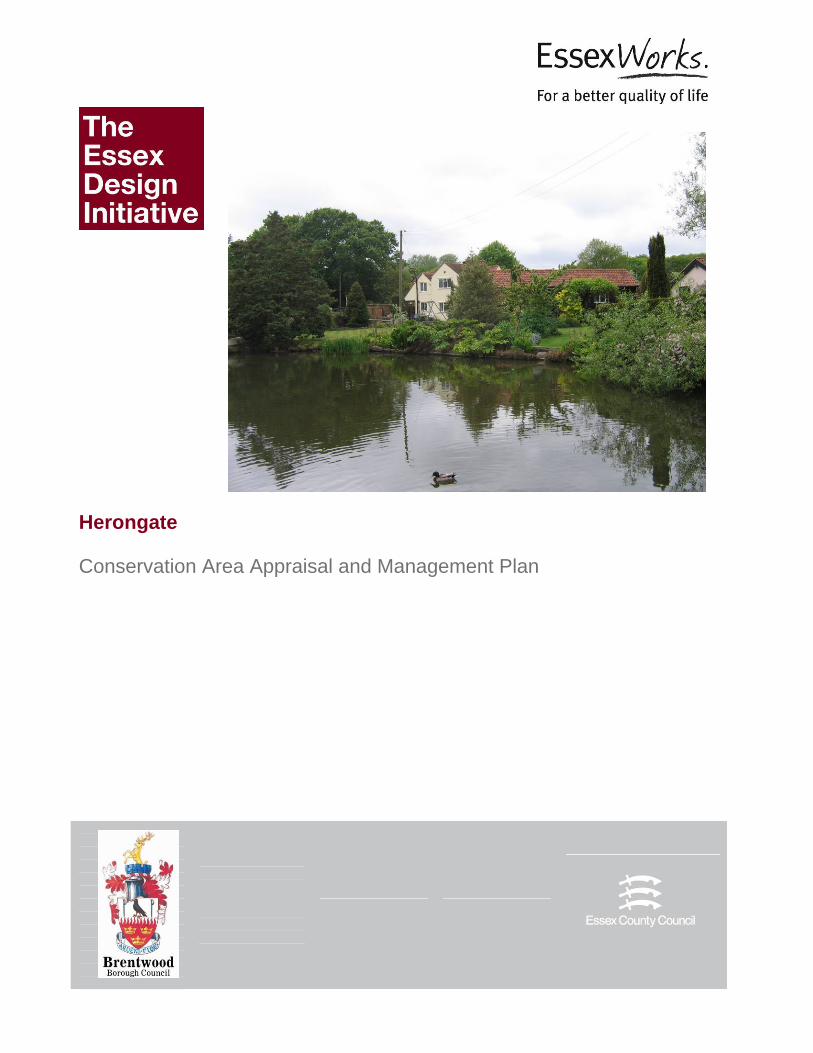
Cover illustration: Herongate Pond This document was produced by Essex County Council for Brentwood Borough Council. The appraisal was prepared by David Andrews, with assistance from Libby Brown and other members of Essex County Council’s Historic Buildings and Conservation Team. The modern maps in this document are reproduced by permission of the Ordnance Survey ® on behalf of the Controller of Her Majesty’s Stationery Office. © Crown Copyright. Licence number LA100019602. © Brentwood Borough Council and Essex County Council 2009.
CONTENTS 1. Introduction 1
2. Planning Policies 2
3. Heritage, Conservation and Other Designations 3
4. Character Statement 5
5. Origins and Development 6 Location and landscape setting Historical development
6. Materials and Detailing 10
7. Uses 13
8. Townscape and Spatial Analysis 14 Green Space Public Realm
9. Character Zones 19
10. Area Analysis 20
11. Evaluation of Contribution to Character 35
12. Management Proposals 36 Problems and Pressures Additional Planning Controls Boundary Changes Locally Listed Buildings Public Open Space Boundary Treatment Redevelopment Sites Signage Services
13. Bibliography 40

This page is intentionally blank.

1
1. INTRODUCTION Brentwood Borough Council commissioned Essex County Council to prepare this Conservation Area Appraisal and Review in January 2007. The research and fieldwork were carried out in March and April 2008. Conservation Areas are ‘areas of special architectural or historic interest, the character or appearance of which it is desirable to preserve or enhance’ (Planning (Listed Buildings and Conservation Areas) Act 1990). They were introduced by the Civic Amenities Act of 1967. Local Authorities have a duty to designate Conservation Areas, to formulate policies for their preservation and enhancement, and to keep them under review. Designation of a Conservation Area extends planning controls over certain types of development, principally the demolition of unlisted buildings and works to trees. Local Authorities will also formulate policies in their local plans or local development frameworks to preserve the character of their Conservation Areas. However, designation does not prevent any change within Conservation Areas and they will be subject to many different pressures (good and bad) that will affect their character and appearance. Government policy for conservation areas is set out in Planning Policy Statement 5: Planning for the historic environment (PPS5), supported by its Statement on the Historic Environment 2010, and the Historic Environment Planning Practice Guide. Conservation areas are treated as part of the wider historic environment, and are considered to be a ‘heritage asset’ like listed buildings and other parts of the historic environment which have some degree of statutory protection. PPS5 states that ‘The Government’s overarching aim is that the historic environment and its heritage assets should be conserved and enjoyed for the quality of life they bring to this and future generations.’ The historic environment is valued not simply for its cultural importance, but also for its contribution to the quality of life, and its potential for facilitating regeneration and economic growth, and in adapting to a more sustainable life style.

2
2. PLANNING POLICIES The Brentwood Replacement Local Plan, adopted August 2005 contains the following statements under ‘Conservation and Protection of the Environment: Conservation Areas’.
9.52 Some parts of the Borough are of significant townscape value worthy of special protection. These areas are usually characterised by groups of buildings of particular architectural or historic interest, the spaces between them and their general setting and character. Designation of such areas as Conservation Areas provides additional statutory powers to control the demolition of buildings and prevent the loss of trees. The design of new development will be carefully controlled to protect and preserve the character of these areas. 9.53 A total of 13 Conservation Areas have been designated so far within the Borough. 9.54 The Council not only has greater power to control development within the Conservation Areas but also has a duty to devise schemes to preserve and enhance the character and appearance of the area. The Council will, therefore, seek to carry out Conservation Area character appraisals, in accordance with PPG15, in order to clearly assess and define their character, allowing informed planning decisions and identification of what should be preserved and enhanced. 9.55 Within Conservation Areas it is necessary to carefully assess the design and materials of any new development proposals. This assessment plays an essential part in determining whether or not a scheme is acceptable in principle. Therefore, in order to ensure a high standard of design and materials, detailed schemes rather than outline applications will normally be required.
Herongate and Ingrave Parish Council have recently carried out a Village Appraisal, the results of which can be found on their website, some of which are relevant to this appraisal. The data will be used for preparing an action plan for the village. 85% of the respondees thought the environment was important to them. An overwhelming majority believe the local villages cannot accommodate additional development. Concern was expressed about litter and the speed of traffic on the A128. An extension to, and reduction of, the present speed limit was favoured. It was agreed that the village hall should be replaced with a community building, though there was a division of opinion as to whether the derelict building should be refurbished or a new building erected.

3
3. HERITAGE, CONSERVATION AREA AND OTHER DESIGNATIONS
Fig. 1: Heritage and other designations in the Conservation Area.
The Herongate Conservation Area was first designated on 12 December 1975 and is one of thirteen Conservation Areas in the Borough. The Area is linear in shape, encompassing mainly older housing, much of it listed, along Cricketers Lane and the Heron Chase footpath at the junction of the A128 with the road to Billericay. The Conservation Area lies within the area zoned for residential use in the Brentwood Local Plan, with the exception of Heron Court which is outside it. The village envelope is surrounded by Green Belt and a Special Landscape Area. Green Belt policies place severe restrictions on new development, on replacement buildings and on extensions to existing buildings. The pond by Heron Chase is identified as a protected open space on the Local Plan. There are 13 grade II listed buildings in the Conservation Area. There are no Scheduled Ancient Monuments within the Conservation Area (though the medieval site of Heron Hall to the north-east is scheduled). There are seven Tree Preservation Orders covering trees or groups of trees in the Conservation Area. Trees within the Conservation Area enjoy protection inasmuch as anyone carrying out works to a tree in a conservation area must give written notification to the planning department at least six weeks beforehand.

4
To the west of the Conservation Area, separated from it by the A128, is the extensive Thorndon Park Conservation Area. A public right of way leads off Cricketers Lane to the north-east to a reservoir and beyond. The Heron Chase footpath which winds between the Boars Head and the pond, and thence down the side of Button Common, is also a public right of way. The appraisal provides a brief history of the development of the village, followed by a description of the Conservation Area and an assessment of its character. The contribution of different elements to its character is identified through detailed street by street analysis.

5
4. CHARACTER STATEMENT Herongate is a village which has grown up along the edge of Ingrave Common. The surviving areas of greensward and open space separate it from the busy A128 road and allow it to retain a coherent identity, whilst the tightly knit groups of older buildings, the public houses, the pond and the church provide the essential character of a traditional village.
6
5. ORIGINS AND DEVELOPMENT
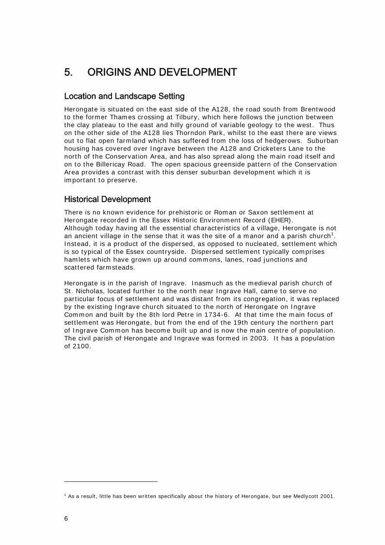
Location and Landscape Setting Herongate is situated on the east side of the A128, the road south from Brentwood to the former Thames crossing at Tilbury, which here follows the junction between the clay plateau to the east and hilly ground of variable geology to the west. Thus on the other side of the A128 lies Thorndon Park, whilst to the east there are views out to flat open farmland which has suffered from the loss of hedgerows. Suburban housing has covered over Ingrave between the A128 and Cricketers Lane to the north of the Conservation Area, and has also spread along the main road itself and on to the Billericay Road. The open spacious greenside pattern of the Conservation Area provides a contrast with this denser suburban development which it is important to preserve.
Historical Development There is no known evidence for prehistoric or Roman or Saxon settlement at Herongate recorded in the Essex Historic Environment Record (EHER). Although today having all the essential characteristics of a village, Herongate is not an ancient village in the sense that it was the site of a manor and a parish church1. Instead, it is a product of the dispersed, as opposed to nucleated, settlement which is so typical of the Essex countryside. Dispersed settlement typically comprises hamlets which have grown up around commons, lanes, road junctions and scattered farmsteads. Herongate is in the parish of Ingrave. Inasmuch as the medieval parish church of St. Nicholas, located further to the north near Ingrave Hall, came to serve no particular focus of settlement and was distant from its congregation, it was replaced by the existing Ingrave church situated to the north of Herongate on Ingrave Common and built by the 8th lord Petre in 1734-6. At that time the main focus of settlement was Herongate, but from the end of the 19th century the northern part of Ingrave Common has become built up and is now the main centre of population. The civil parish of Herongate and Ingrave was formed in 2003. It has a population of 2100.
1 As a result, little has been written specifically about the history of Herongate, but see Medlycott 2001.

7
Fig.2: Detail from Chapman and André map of Essex, 1777, showing Herongate.
Fig. 3: Part of the Ingrave Tithe Map of 1839 (courtesy of Essex Record Office).

8
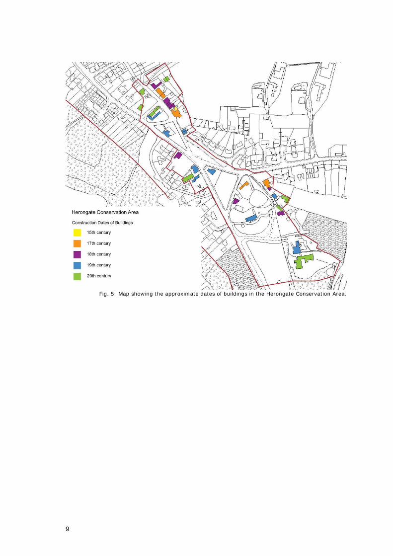
Herongate itself takes its name from Heron Hall, indicating that it was at the approach to the Hall. This was one of the manors of East Horndon. It belonged from the 14th century to the Tyrells, one of the most ancient and enduring of Essex aristocratic families. From the 15th century, the Tyrell manor house had the appearance of a brick built castle with round towers enclosed by a moat. It was demolished after the death of the last Tyrell in 1788. Today only the moat survives. The earliest map to show the Herongate area, the 1598 estate map for the Petre manors of East and West Horndon (ERO D/DP P5), already indicates several houses along the east side of Ingrave Common. Although these look in much the same position as some of the houses that exist today in Cricketers Lane, according to the list descriptions only one of these pre-dates the 17th century. The situation is similar on the Chapman and André Essex map of 1777, though rather more houses are represented at the edge of the Common and there is a discrete cluster of buildings round the junction with the Billericay road. The Tithe Map of 1839 (ERO D/CT 193) shows clearer evidence for encroachment on the Common, which was waste of the manor in the ownership of Lord Petre: Cricketers Lane is emerging as a distinct thoroughfare, and the Stock Yard was in existence. The first edition OS map of 1876 shows further encroachment on the Common by roads and houses. By this time the basic fabric of the village was in place, there having been relatively little change since, despite pressure to infill for new housing. To the south, the common, identified as The Green or Herongate Common on old maps, and Button Common on modern ones, has remained intact. The evidence of former shopfronts fossilized in house facades, indicates that a range of trades was formerly carried on at Herongate. The approximate construction dates of buildings that make up the village today are shown in Fig. 5.
Fig.4:1st edition Ordnance Survey map, 1876.
9
Fig. 5: Map showing the approximate dates of buildings in the Herongate Conservation Area.

10
6. MATERIALS AND DETAILING Houses are vernacular in style, mostly having a plain Georgian appearance. The only exception is Heron Court, a country house in the Arts and Crafts style. Ground plans are narrow, 5-7m wide, and houses are one-and-a-half or two storeys in height. Only rarely do the two storey houses have attic rooms lit by dormer windows. The older buildings are timber-framed, but their frames are plastered or clad in weatherboard and not exposed. Both plaster and weatherboard are white painted. Weatherboard is traditionally featheredged (e.g. 27 Cricketers Lane, 197 Brentwood road), but the more formally detailed shiplap boarding is used on St. Andrews church and is entirely appropriate to a public building of this sort. On houses and higher status buildings it is normally painted white, but on agricultural buildings such as the Stock Yard, it is black or tarred.
Fig. 6 (left): Feather-edged weatherboard, with a sliding sash window, beneath a roof of hand-made peg
tiles (27 Cricketers Lane). Fig. 7 (right): Shiplap weatherboard, and a Gothic style window with a top-opening hopper, beneath a
natural slate roof (St. Andrew’s church).
Nos 15-19 and 25 Cricketers Lane are good examples of Georgian red brickwork, laid to Flemish bond with a scatter of darker headers. Early examples of the use of brick for housing are often no more than a facing of a timber frame, as can be seen at nos 5-7 Cricketers Lane which have a brick front but weatherboarded sides and back. The more expensive gault or white bricks are only to be found in the Friars, a large house at the north end of Button Common.
11
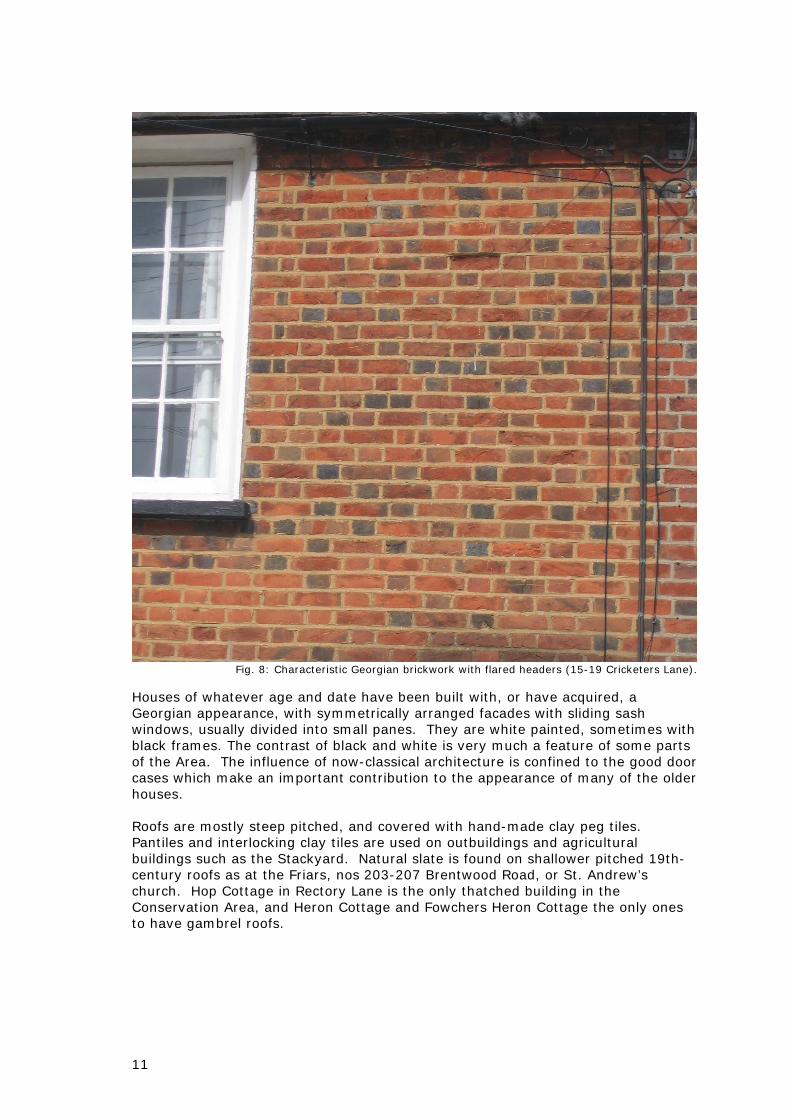
Fig. 8: Characteristic Georgian brickwork with flared headers (15-19 Cricketers Lane).
Houses of whatever age and date have been built with, or have acquired, a Georgian appearance, with symmetrically arranged facades with sliding sash windows, usually divided into small panes. They are white painted, sometimes with black frames. The contrast of black and white is very much a feature of some parts of the Area. The influence of now-classical architecture is confined to the good door cases which make an important contribution to the appearance of many of the older houses. Roofs are mostly steep pitched, and covered with hand-made clay peg tiles. Pantiles and interlocking clay tiles are used on outbuildings and agricultural buildings such as the Stackyard. Natural slate is found on shallower pitched 19th-century roofs as at the Friars, nos 203-207 Brentwood Road, or St. Andrew’s church. Hop Cottage in Rectory Lane is the only thatched building in the Conservation Area, and Heron Cottage and Fowchers Heron Cottage the only ones to have gambrel roofs.

12
Fig. 9: Pantile roof (20 Cricketers Lane).
Boundary treatments can make a significant impact on the appearance of their surroundings. Low brick walls with planting behind them, picket fences and hedges are the boundaries most typical of the Conservation Area. White painted picket fences are a particularly distinctive feature of Heron Chase. Excessively elaborate iron gates of the sort to be found at the north end of Cricketers Lane, just beyond the Conservation Area, would not be appropriate in the Conservation Area.
Fig. 10 (left): White painted picket fences in Herons Chase.
Fig. 11(right): Iron gates at the north end of Cricketers Lane.
13
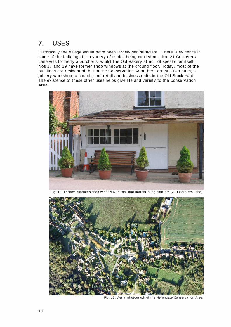
7. USES Historically the village would have been largely self sufficient. There is evidence in some of the buildings for a variety of trades being carried on. No. 21 Cricketers Lane was formerly a butcher’s, whilst the Old Bakery at no. 29 speaks for itself. Nos 17 and 19 have former shop windows at the ground floor. Today, most of the buildings are residential, but in the Conservation Area there are still two pubs, a joinery workshop, a church, and retail and business units in the Old Stock Yard. The existence of these other uses helps give life and variety to the Conservation Area.
Fig. 12: Former butcher’s shop window with top- and bottom-hung shutters (21 Cricketers Lane).
Fig. 13: Aerial photograph of the Herongate Conservation Area.
14
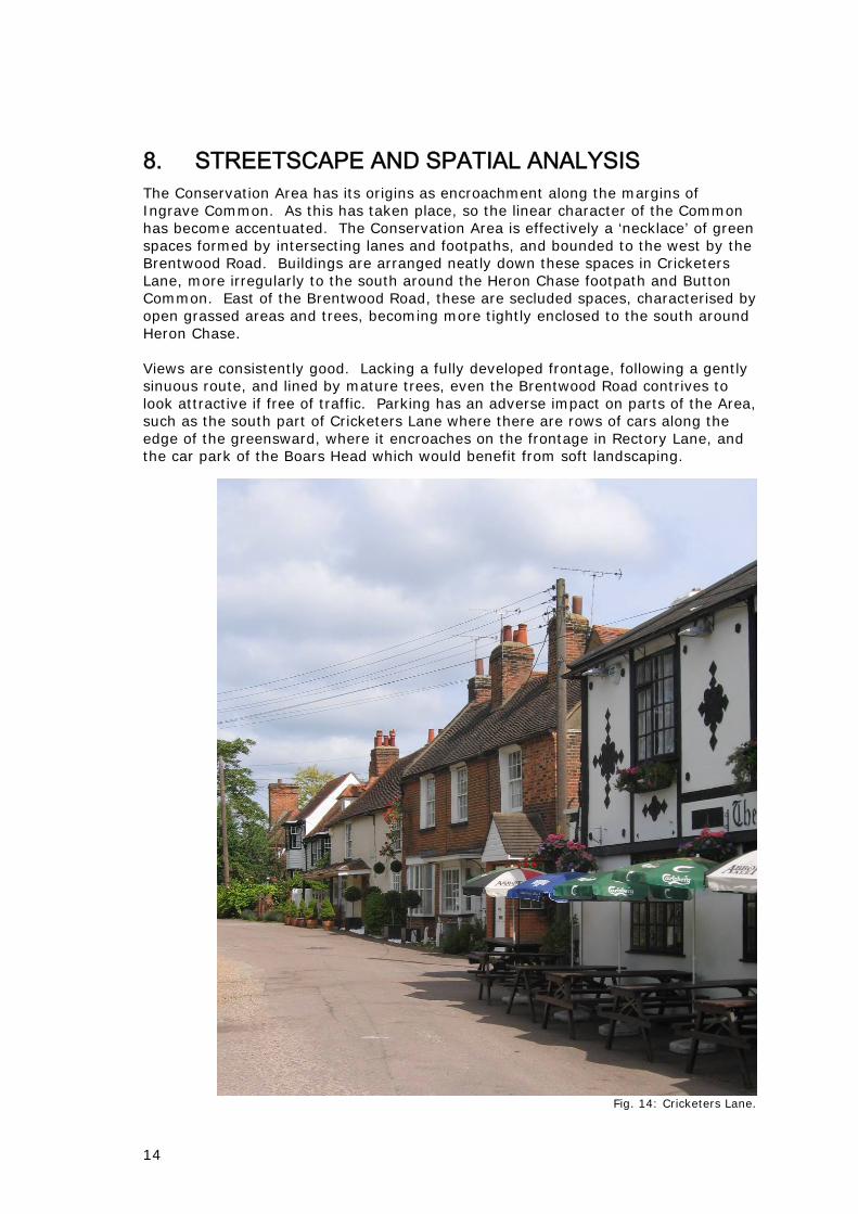
8. STREETSCAPE AND SPATIAL ANALYSIS The Conservation Area has its origins as encroachment along the margins of Ingrave Common. As this has taken place, so the linear character of the Common has become accentuated. The Conservation Area is effectively a ‘necklace’ of green spaces formed by intersecting lanes and footpaths, and bounded to the west by the Brentwood Road. Buildings are arranged neatly down these spaces in Cricketers Lane, more irregularly to the south around the Heron Chase footpath and Button Common. East of the Brentwood Road, these are secluded spaces, characterised by open grassed areas and trees, becoming more tightly enclosed to the south around Heron Chase. Views are consistently good. Lacking a fully developed frontage, following a gently sinuous route, and lined by mature trees, even the Brentwood Road contrives to look attractive if free of traffic. Parking has an adverse impact on parts of the Area, such as the south part of Cricketers Lane where there are rows of cars along the edge of the greensward, where it encroaches on the frontage in Rectory Lane, and the car park of the Boars Head which would benefit from soft landscaping.
Fig. 14: Cricketers Lane.

15
Fig. 15 (left): Greensward at the south end of Cricketers Lane with the attractive village sign, and cars
parked along it. Fig. 16 (right): The extensive asphalt car park in front of the Boars Head which lacks any form of
boundary treatment.
8.2 Green space The green space which is so much a feature of the Conservation Area is all informal, not over-managed nor yet showing signs of inadequate maintenance. This balance is quite appropriate, given the piecemeal way the settlement has developed on the Common and the vernacular character of most of the buildings. The trees are mostly native species, and often self-sown in origin. The only formal planting is the row of horse chestnuts along the footpath on the greensward that adjoins Donovans Gardens, but here any effect of regularity is reduced by the hawthorn and other trees which form a thicket on the other side of the path.
Fig. 17: Footpath across the greensward at the Billericay Road junction.
16
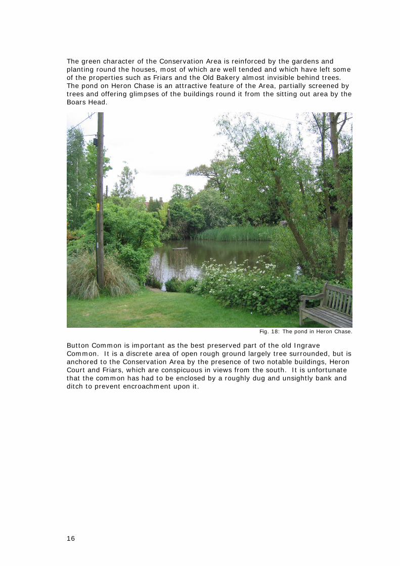
The green character of the Conservation Area is reinforced by the gardens and planting round the houses, most of which are well tended and which have left some of the properties such as Friars and the Old Bakery almost invisible behind trees. The pond on Heron Chase is an attractive feature of the Area, partially screened by trees and offering glimpses of the buildings round it from the sitting out area by the Boars Head.
Fig. 18: The pond in Heron Chase.
Button Common is important as the best preserved part of the old Ingrave Common. It is a discrete area of open rough ground largely tree surrounded, but is anchored to the Conservation Area by the presence of two notable buildings, Heron Court and Friars, which are conspicuous in views from the south. It is unfortunate that the common has had to be enclosed by a roughly dug and unsightly bank and ditch to prevent encroachment upon it.

17
Fig. 19: Button Common.
8.3 Public realm Although lined with trees and essentially green in character, the Brentwood Road suffers from an excess of overhead wires and poles, and signage which could be rationalised. There is a nice old finger post at the Billericay Road junction, but by St. Andrew’s church there is a cluster of signs which do not enhance this focal point in views down the road. The arrows indicating a bend are redundant, as is one of the two Brentwood Joinery signs positioned here. The lamp standards along the road are of slightly differing functional designs which do not do justice to the Conservation Area. A very nice feature of the Conservation Area is the village sign made of glazed tiles by Irene Wells (1981) at the south end of Cricketers Lane (Fig. 15).
Fig. 20 (left): Lamp standards, signs and a speed camera at the entrance to the Conservation Area.
Fig. 21 (right): Poles, wires, street lights and a confusion of signs and symbols by St. Andrew’s church, a focal point in views down the Brentwood Road.

18
The surface of Cricketers Lane is uneven and patched. The Herons Chase footpath is asphalted (Fig. 10). Its southern end is partially closed off with galvanised tubular railings of a type unworthy of this location. The tracks leading from Herons Chase to the Brentwood Road and Herons Court are of very worn asphalt and concrete. Beneath the row of chestnuts along the footpath on the greensward linking Cricketers Lane and Billericay Road, there are two wooden benches in a rather neglected condition. There is a single bench on Button Common by the entrance to Heron Court.

19
9. CHARACTER ZONES The Conservation Area can be divided into character zones on the basis of visually unifying factors arising from the character and density of the built environment and its relationship to the surrounding green spaces and roads. They are: 1. The northern part of the Conservation Area, buildings grouped along Cricketers Lane and around the Billericay road junction, strung out along open patches of greensward, or clustered round the junction and the pond at Heron Chase. 2. The Brentwood Road and the part of the Conservation Area round Heron Cottage on the west side of it. Although this zone takes its character largely from the road, it shares with the other parts of the Area the features of low density and large areas of open space, though in this case garden rather than open greensward. 3. Button Common and the buildings bordering on to it, namely Button Hall, Friars and Heron Court. This is the most wooded part of the Conservation Area, being largely enclosed by mature trees, which also succeed in effectively screening the Brentwood Road.
Fig. 22: Analysis of the townscape character of the conservation area.

20
10. AREA ANALYSIS This section will describe the character of the Conservation Area on a road by road basis, from north to south.
Cricketers Lane Originally a track giving access to houses at the edge of Ingrave Common, Cricketers Lane is a narrow road with an indifferent surface, terminating to the north in a footpath. At its southern end it runs between wedge-shaped areas of grass, remnants of the Common, that to the east with a footpath across it below a row of horse chestnuts, and that to the west with the overgrown site of the village hall. Cars are parked along this grassed area, small wooden dragon’s teeth serving to prevent them encroaching on it. Nos 5-7 Cricketers Lane A pair of brick fronted 19th-century cottages, weatherboarded on sides and back. Extended on south side and to rear. Low pitch roof, now in artificial slate. Sash windows in the brickwork, casements in sides. Well maintained and attractive.
Fig. 23: 5-7 Cricketers Lane.
No. 11 Cricketers Lane Green Man Inn: grade II listed, timber-framed. Comprises a 19th-century front range with a low pitch slate roof built in front of older buildings which include the 17th-century cross-wing of a medieval hall house, the whole now much altered and modernised. It is very distinctive, white rendered with pargetted patterns picked out in black, co-ordinated with the black painted joinery. Indifferent pointing has an adverse effect on the appearance of a modern extension in stock brick on the south side. In contrast, the brickwork of the new red brick wall is much better; this is a good solution to screening off the beer garden, though the marquee style smoking shelter can be seen above it.

21
Fig. 24: The Green Man.
No. 13 Cricketers Lane A small grade II listed house concealed behind the Green Man, unassuming yet the oldest known building in the Conservation Area, dating from the 15th century. It is a cross-wing, a fragment of a medieval hall house. Nos 15, 17 and 19 Cricketers Lane Grade II listed, a row of late 18th-century brick houses. The rear wings are unusually tall, the ridges slightly higher than the front range. The bay windows of nos 17 and 19 were originally shop windows. No. 15 has not been enhanced by a porch.
Fig. 25: 15-19 Cricketers Lane.

22
No. 21 Cricketers Lane Grade II listed18th-century former butcher’s shop, shambles and associated house. Converted to a house c.1980. Timber-framed beneath painted rough-cast façade and weatherboarding to sides. To front left, beneath a pent roof, early 19th-century shop window with top- and bottom-hung shutters.
Fig. 26: 21 Cricketers Lane.
No. 25 Cricketers Lane “Ingrave Cottage”, grade II listed, late 17th-century and later, timber-framed with a clasped purlin roof, but now clad in brick on the front. Two 20th-century bow windows possibly replacing shop windows. Rear extension of c.1983. Pedimented door canopy on iron brackets.
Fig. 27: 25 Cricketers Lane.
23
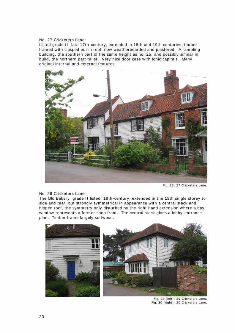
No. 27 Cricketers Lane: Listed grade II, late 17th-century, extended in 18th and 19th centuries, timber-framed with clasped purlin roof, now weatherboarded and plastered. A rambling building, the southern part of the same height as no. 25, and possibly similar in build, the northern part taller. Very nice door case with ionic capitals. Many original internal and external features.
Fig. 28: 27 Cricketers Lane.
No. 29 Cricketers Lane The Old Bakery grade II listed, 18th-century, extended in the 19th single storey to side and rear, but strongly symmetrical in appearance with a central stack and hipped roof, the symmetry only disturbed by the right hand extension where a bay window represents a former shop front. The central stack gives a lobby-entrance plan. Timber frame largely softwood.
Fig. 29 (left): 29 Cricketers Lane.
Fig. 30 (right): 20 Cricketers Lane.
24
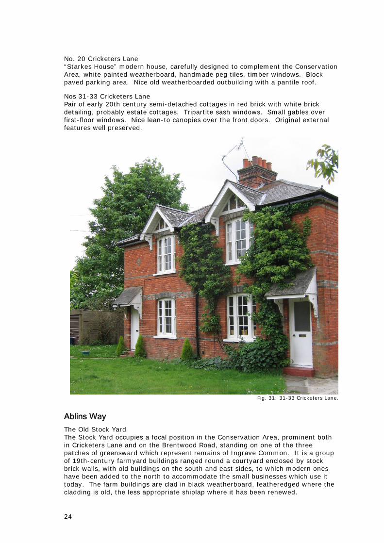
No. 20 Cricketers Lane “Starkes House” modern house, carefully designed to complement the Conservation Area, white painted weatherboard, handmade peg tiles, timber windows. Block paved parking area. Nice old weatherboarded outbuilding with a pantile roof. Nos 31-33 Cricketers Lane Pair of early 20th century semi-detached cottages in red brick with white brick detailing, probably estate cottages. Tripartite sash windows. Small gables over first-floor windows. Nice lean-to canopies over the front doors. Original external features well preserved.
Fig. 31: 31-33 Cricketers Lane.
Ablins Way The Old Stock Yard The Stock Yard occupies a focal position in the Conservation Area, prominent both in Cricketers Lane and on the Brentwood Road, standing on one of the three patches of greensward which represent remains of Ingrave Common. It is a group of 19th-century farmyard buildings ranged round a courtyard enclosed by stock brick walls, with old buildings on the south and east sides, to which modern ones have been added to the north to accommodate the small businesses which use it today. The farm buildings are clad in black weatherboard, featheredged where the cladding is old, the less appropriate shiplap where it has been renewed.

25
Fig 32: The Old Stock Yard.
Brentwood Road (A128) This busy road effectively severs the small group of buildings on its west side that are included in the Conservation Area from those to the east which are located in a greener and more spacious setting on what was the edge of Ingrave Common. No. 176 Brentwood Road Old Church Hall: late 19th-century, formerly a school, located on a triangular patch of greensward between the Brentwood Road and Cricketers Lane. White painted brickwork, nice old windows, some with hood moulds, later porch added to the front. Low pitched slate roof. Now ivy grown and in poor but retrievable condition. The attached garden area is very overgrown, mainly with self-sown sycamore trees which are now very tall.
Fig. 33: The old village hall.

26
No. 197 Brentwood Road “Heron Cottage” grade II listed, 18th-century, extended in 19th early 20th. Timber-framed and weatherboarded under a gambrel roof. Chimney stacks at each gable end. Former shop window to right of front door under a pent roof. At the back there are several phases of extensions, and then a row of old outbuildings. Picket fence to the front of the house, close boarded fence round the garden, two mature trees flank the entrance drive.
Fig. 34: Heron Cottage.
St. Andrew’s Methodist church Dating from 1881, white-painted shiplap weatherboard with black windows and details, slate roof, very attractive and beautifully maintained. Original windows with top-opening hoppers with arched glazing bars. Three lancet windows in the south elevation. Hooped railings and hedge round plot. This was probably a prefabricated timber-framed building of the sort often used for small churches in the 19th and early 20th centuries. The church stands in a key position at the junction of the Brentwood and Billericay Roads. By the front door there is a plain granite war memorial in the form of a simple cross, in a rather cramped position which creates visual confusion with the building adjacent to it.

27
Fig. 35: St. Andrew’s church.
No. 192 Brentwood Road “Friars” grade II listed, early 19th-century white gault brick, low pitch hipped slate roof. Cast iron verandah to front of main range, possibly original. Early extensions to left and right of main building which has a symmetrical double fronted façade which forms an important view on the north side of Button Common. Electrically operated gates. Formerly called the Elms on old maps.
Fig. 36: Friars.

28
No. 198 Brentwood Road “Heron Court” stands on the site of an earlier house which at one time was lived in by the great-uncle of Baden Powell, who was rector of the parish 1795-1831. The existing house is shown on the first edition OS map of 1876. A rear extension is dated 1892. It is a large Arts and Crafts style house, red brick at the ground floor, black and white false half timbering to the first and attic storeys. Prominent chimney stacks with tall decorative Tudor style pots in pale terracotta. It resembles the houses designed by George Sherrin in Ingatestone, but the identity of the architect is not known. A bay has been added on the north side, whilst to the south it has been much extended to the south for use as a care home. Permission was granted on appeal for first-floor extensions to these existing single storey buildings. Application was made in 2007 to demolish and to build a new care home on the site but was refused on appeal on grounds of inappropriate development in the Green Belt, the bulk scale and indifferent design of the proposed new building, and the loss of the existing building. Although acknowledging its architectural merit, English Heritage rejected Heron Court for listing in 2008 because of the external extensions and internal alterations. In advice on the proposed scheme, English Heritage noted the important visual relationship that Heron Court has with Button Common.
Fig 37: Heron Court.
Nos 203a-205a Brentwood Road Row of 19th-century cottages, now divided into flats, rendered and white painted, hipped slate roof, four red brick chimneys. 203 still has a ground-floor bay window, but otherwise the appearance of the building has been drastically altered for the worse through the construction of a lean-to extension along half of the front elevation and alterations to the first-floor fenestration. Replacement UPVC windows throughout.

29
Fig. 38: 203a-205a Brentwood Road.
No. 203 Brentwood Road Brentwood Joinery Ltd industrial workshops set well back from the road, and thus with little impact on the appearance of the Conservation Area. More noticeable are the advertisement boards on the frontage and by St. Andrew’s church.
Fig. 39: Brentwood Joinery.
No. 209 Brentwood Road “Brewsters” an old building at right angles to the road, partially in attractive Georgian brickwork and partially in white weatherboard, recently extended in

30
reused brick on an L-shaped plan with the addition of garages. Roof covering concrete pantiles.
Fig. 40: 209 Brentwood Road.
The well tended allotments are screened by hedging and trees and are barely visible from the Brentwood Road, more conspicuous on Rectory Road.
Heron Chase Heron Chase is a narrow asphalted right of way which runs from the Boar’s Head between the pond and a small cluster of buildings down to Button Common. The buildings along it are in much the same style, Georgian in appearance, with black and white paintwork, and fronted by white picket fences, giving the Chase a very strong identity. Rose Cottage An 18th-century house with a lightweight timber frame on the south-east side of the Boar’s Head, added to the list in 1995. White painted render, characteristic black and white painted joinery, sliding sash windows, clay peg tiles. In its appearance and decorations, it complements the Boar’s Head with which it forms a group. It is rather dwarfed by a large sycamore in front of it.

31
Fig. 41: Rose Cottage.
No. 5 Heron Chase “Elms Cottage” a refurbished 19th-century house, white rendered, double-glazed timber sash windows, slate roof. In appearance and decorations it blends well with Rose Cottage and the Boar’s Head and forms a group with them. The new porch, however, though carefully detailed, is not entirely successful and shows how difficult it is to design satisfactory porches. Modern weatherboarded garage to one side.
Fig. 42: 5 Heron Chase.
Fig. 43: Herons Retreat, Heron Chase.

32
Herons Retreat A detached house built in the 1990s adjacent to Elms Cottage, in a style similar to the other buildings in Heron Chase, i.e. white painted with sash windows and of Georgian appearance, but making a rather curious collision with a weatherboarded wing. Button Hall Grade II listed, 18th-century house much extended in the 20th century. Timber-framed, some of it softwood, and plastered. Gable end stacks. Central front door now replaced by a window. Like the other buildings here it has black and white paintwork, but the windows in this case are side opening casements. Large 20th-century extensions to the rear and the north which are beginning to impinge on the character of the house. These, and the house itself, are however largely invisible behind a high hedge and trees.
Fig. 44: Button Hall.
Rectory Lane In origin presumably a cut-through across the Common from the Billericay to the Brentwood Roads. Rural in character, with the allotments on one side, and two low one-and-a-half storey cottages on the other, though the setting of these is beginning to be compromised by the proliferation of garages and parking.

33
Fig. 45: Parking in Rectory Lane.
Nos 5 and 7 Rectory Lane “Hop Cottage” grade II listed,17th-18th-century, now one house, extended and altered in 20th century. One storey with attics under a long-straw thatched roof with a block-cut ridge. Rendered with a weatherboarded plinth. Screened by trees and hedging; principal elevation is now to the rear where three large gables face the pond on Heron Chase.
Fig. 46: Hop Cottage.
Fowchers Heron Cottage One-and-a-half storey, a central stack suggests a lobby-entrance plan and a 17th- to 18th-century date. Extended to the rear. The windows are mostly in UPVC. Not enhanced by a large prefabricated flat-roofed garage.

34
Fig. 47: Fowchers Heron Cottage.
Billericay Road Boar’s Head public house. 17th-century and later. Much extended giving complex plan. Timber-framed and plastered. Whilst the side of the building down Herons Chase is attractively laid out with wooden tables and seating, and a picket fence, from the main road it is approached across a very extensive tarmac car park which would benefit from soft landscaping.
Fig. 48: The Boars Head and Heron Chase.

35
11. EVALUATION OF CONTRIBUTION TO CHARACTER A map showing an assessment of the contribution of individual buildings to the special character and appearance of the Conservation Area is shown in Fig. Each building has been graded on a scale of one to three according to the following criteria:
1. Positive contribution through design, age, materials or detailing, or through historic interest. 2. Buildings which have a neutral presence in the Conservation Area, fitting satisfactorily into it. 3. Buildings worthy of retention, but which make a negative contribution to the area because of unsympathetic alterations and modernisation, or because of lack of maintenance.
Fig. 49: Contribution of buildings to the character of the Conservation Area.

36
12. MANAGEMENT PROPOSALS
Problems and pressures The Conservation Area shares many of the problems typical of places which are attractive to live: any available land is an opportunity for development and infilling, and people want to make their houses larger and to surround them with ancillary buildings. There are spaces within the village envelope where there is likely to be development pressure, as is also likely to be the case at Heron Court in the Green Belt. However, Herongate is a low density settlement where the spaces between the buildings are crucial to its appearance, as well as a reminder of its origins as a settlement along a common. It is what the Essex Design Guide terms a rural system, in which the landscape contains the buildings, rather than the buildings containing the spaces in which they stand. At Herongate, most houses have already been extended several times leaving no scope for further enlargement. None of the listed buildings could readily accept further extension without an adverse effect on their character. As a mature village of well defined and established character, Herongate has limited potential for change without it having a major effect on its character. Opportunity for development is constrained by Brentwood Borough’s conservation area and Green Belt policies, and only if these were revised would significant change become possible. It is recommended that the Borough’s existing conservation area and Green Belt policies are implemented effectively to preserve the character of the Conservation Area.
Additional planning controls The greatest threat to the character and appearance of Conservation Areas is their gradual erosion by minor changes, such as, most of which are permitted development and thus do not require planning permission. Under the 1990 Planning Act, the local planning authority can bring many of these changes within the remit of the planning system, with the use of Article 4(2) Direction. Although there are relatively few instances at Herongate of such things as inappropriate replacement windows and doors, and many of the buildings are listed, conservation areas enjoy little protection unless permitted development rights are curtailed, and it is therefore recommended that an Article 4(2) Direction be introduced to control the following works:
• Alteration of a dwelling house affecting windows, doors or other openings to the front and side elevations including the insertion of dormer or other windows in the roof and the change of roof materials.
• The application of any form of cladding or rendering to the external walls and front and side elevations.
• The erection or construction of a porch outside the front or side door of a dwelling house.
• The erection or construction of any fences, walls, gates or other forms of enclosure to the front or sides of a dwelling house.
• The construction within the curtilage of a dwelling house of a vehicle hard standing incidental to the dwelling house.
• The painting of the exterior of any wall of a dwelling house with a different colour.
• The installation of solar panels and wind turbines.
37
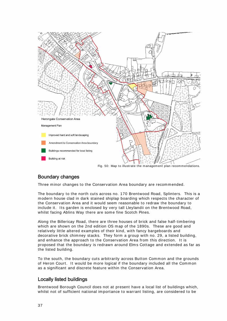
Fig. 50: Map to illustrate the management plan recommendations.
Boundary changes Three minor changes to the Conservation Area boundary are recommended. The boundary to the north cuts across no. 170 Brentwood Road, Splinters. This is a modern house clad in dark stained shiplap boarding which respects the character of the Conservation Area and it would seem reasonable to redraw the boundary to include it. Its garden is enclosed by very tall Lleylandii on the Brentwood Road, whilst facing Ablins Way there are some fine Scotch Pines. Along the Billericay Road, there are three houses of brick and false half-timbering which are shown on the 2nd edition OS map of the 1890s. These are good and relatively little altered examples of their kind, with fancy bargeboards and decorative brick chimney stacks. They form a group with no. 29, a listed building, and enhance the approach to the Conservation Area from this direction. It is proposed that the boundary is redrawn around Elms Cottage and extended as far as the listed building. To the south, the boundary cuts arbitrarily across Button Common and the grounds of Heron Court. It would be more logical if the boundary included all the Common as a significant and discrete feature within the Conservation Area.
Locally listed buildings Brentwood Borough Council does not at present have a local list of buildings which, whilst not of sufficient national importance to warrant listing, are considered to be

38
of local importance. However the Replacement Local Plan at paragraph 9.57 states that they will seek to compile a list of buildings of local or historic interest. The buildings will be assessed using defined criteria and are likely to be good examples of a particular design, type of construction, the work of a local architect or a building associated with an important local figure. Inclusion in the list would be a material consideration in determining planning applications, and thus ensure that important original features and fabric are retained, and that alterations do not damage the character of the building. Two buildings in the Conservation Area could be placed on such a list. Heron Court is a good example of an Arts and Crafts house, and of imposing size occupying a significant position on Button Common. St. Andrew’s church is a well preserved and attractive example of a prefabricated wooden building which stands at a focal point at the junction of the Brentwood and Billericay Roads. It is recommended that Heron Court and St. Andrew’s church should be considered for inclusion on a local list if one were to be adopted by the Local Authority.
Building at risk The village hall in its present state is an eyesore in a very prominent position. It is a decent building suited to its location and worthy of being saved. The longer it is left to decay, the more that will cost. An end use should be identified for it and measures taken to restore it. At the very least urgent action should be taken to control the vegetation, and in particular the ivy, growing around it.
Public realm The appearance of Brentwood Road would be improved with the use of lamp standards more suited to a conservation area. An audit of signs and street furniture could be made to cut down on clutter. Signage around the Methodist church, both street signs and signs belonging to the church and Brentwood Joinery, could be rationalised to tidy up this focal view down Brentwood Road and also to make the signs more effective as at the moment there is visual confusion. For the same reason, a case could be made for moving the War Memorial to a more open and less cramped site on one of the areas of greensward. The clutter of above ground electricity and telephone cables and associated poles make a considerable intrusion into views down Brentwood Road. Running these cables below ground would be a considerable visual improvement and any opportunity to do so should be taken. Cricketers Lane needs to be completely resurfaced. Consideration should be given to using a bound gravel surface which would look more in keeping with the Conservation Area. Bound gravel surfacing would be more appropriate than tarmac when Herons Chase and the footpath across the greensward by Donovans Gardens have to be relaid. This type of surface would also be an improvement on the tracks round the north end of Button Common and south of Herons Chase which also need improvement. Better quality railings could be installed at the south end of Herons Chase. The erection of ‘gateways’ at the Conservation Area boundaries on the A128 would make motorists more aware of the existence of the Area as a discrete place and might encourage them to drive more carefully.

39
Public Open Space The open green spaces, and the established trees and hedges, are extremely significant elements of the character of the Herongate Conservation Area. Any erosion of them by incremental changes such as alterations to boundary treatments or car parking should be resisted. The current management of open spaces which successfully keeps them under control but avoids formality should be maintained. The row of chestnuts along the footpath by Donovans Gardens would be improved by crown lifting. This would make the two benches beneath them more usable: at present they are shrouded by the branches of the trees. There is a case for one or two more benches on the greensward, perhaps near the village sign or opposite the Green Man. Pink and white chestnuts have been planted along the west side of Button Common. Although attractive, these are beginning to fully enclose what was an open communal space. These trees and the scrub between them should be managed so that there are views into the Common from the road.
Soft landscaping The Boars Head car park is a large area of tarmac which makes for a poor approach to an attractive building and to Herons Chase. There is no boundary separating it from the Billericay Road. Its appearance would be much enhanced if there were a hedge, or a hedge and picket fence, in front of it, the sort of boundary treatment typical of the Conservation Area. It would also benefit from a more sympathetic surface treatment, and the planting of some trees or shrubs. The setting of the Stock Yard could be enhanced by the planting of one or two carefully sited trees.

40
13. BIBLIOGRAPHY Department for Communities and Local Government 2010 Planning Policy Statement 5: Planning for the historic environment, TSO. Department for Communities and Local Government, English Heritage and Department of Culture Media and Sport 2010 PPS5 Planning for the historic environment: Historic environment planning practice guide. Department for Culture Media and Sport 2010 The Government’s statement on the historic environment for England 2010. ERO Essex Record Office Essex County Council and Essex Planning Officers Association 2005 The Essex Design Guide for residential and mixed use areas, Chelmsford: Essex County Council. Medlycott, M. 2001 Herongate and Ingrave. Historic settlement assessment report, Essex County Council (unpublished report).