hawkesbury canoe and kayak trail
DESCRIPTION
Hawkesbury Canoe and Kayak TrailOriginal Copy from LPMATRANSCRIPT
www.lpma.nsw.gov.au
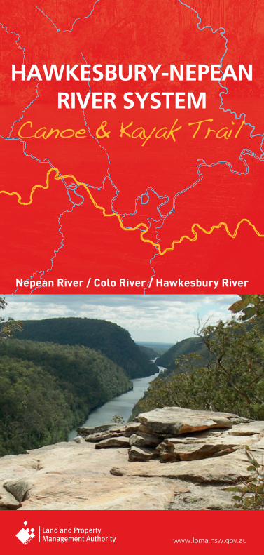
Nepean River / Colo River / Hawkesbury River
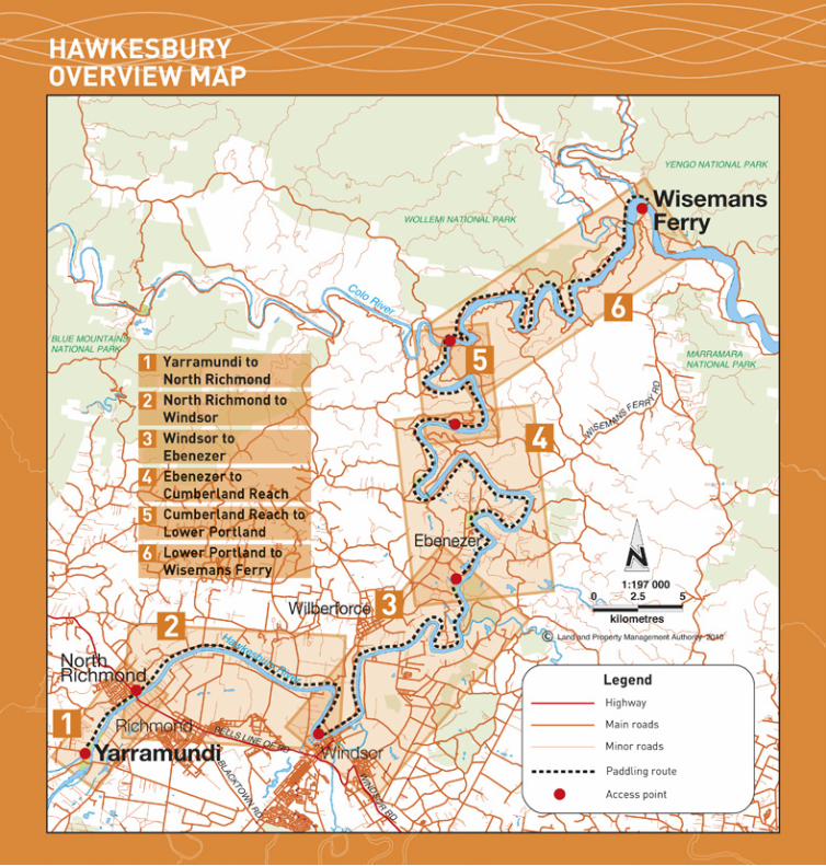
HAWKESBURY-NEPEAN RIVER SYSTEM
Canoe & Kayak Trail
GPS coordinates have been used to locate critical points along the river. These Coordinates are based on the GDA datum.
• Your GPS should be set up to Datum Mode: GDA (or WGS), Position: UTM/UPS, Units: Metric, and North Reference: True.
• The coordinates will only refer to the Zone you are in. You must state the zone if contacting emergency services. The Hawkesbury River Zone is 56.
ABOUT GPS (Global Positioning System)
Welcome to three canoeing and kayaking opportunities on the Hawkesbury-Nepean River System.
The Hawkesbury River has numerous sections and tributaries which are well suited to recreational canoeing and kayaking. It offers spectacular scenery and an abundance of wildlife.
Crown and Council Reserves provide places where the public can get access to the river to start or finish your trip.
The Hawkesbury-Nepean River SystemThe Hawkesbury River is formed by the confluence of the Grose and Nepean Rivers just north of Penrith in New South Wales. The Grose River rises near Mt Victoria in the Blue Mountains, and the Nepean River near Wollongong some 80 kms south of Sydney. The Nepean River is joined by the Warragamba River south of Penrith. These two rivers together capture much of the water for the city of Sydney and the Sydney Basin. The largest of the dams is Warragamba Dam on the Warragamba River just up stream from its junction with the Nepean.
Canoe trailsThere are three Canoe and Kayak adventures described in this booklet
• Nepean River Canoe and Kayak Trail (up to 50 kms)• Colo River Canoe and Kayak Trail (30 kms)• Hawkesbury River Canoe and Kayak Trail (83.5 kms)
Each of these trips has its own characteristics and you will be sure to find one that meets your needs.
Degree of difficultySignificant falls of rain in the catchments of any of these rivers can change their water quite quickly. The changes are quite short lived however and for most of the time these three canoe trails are slow moving flat water with no rapids, and are quite suited to recreational canoeists with beginner skills. Some degree of endurance will be required on the longer reaches, particularly if a head wind or tide is encountered.
The upper reaches of the Colo can be quite shallow after dry spells, but the bottom is sandy and easy to walk towing your canoe.
The Hawkesbury River is popular for speed boating and skiing. These activities can create real problems for canoeists and speed boats alike. It is best to canoe the popular areas when speed boating activity is low.
It is also advisable to plan canoeing on the Hawkesbury and lower Colo River to coincide with the tide.
Canoe and kayak trail mapsThe canoe trail maps have been prepared by the Land and Property Management Authority to show the public where they can gain
WELCOME
access to the water. With this and the other information provided, you can plan your canoe/kayak trip.
Public access to the river is provided by public or Crown reserves. Some of these reserves have public facilities such as toilets and boat ramps. The location of these reserves is shown on the maps but they have also been given a GPS Coordinate so that you can find them from the water.
There are numerous riverside caravan parks, tourist parks and ski resorts along the river where you can also get access to the river and obtain accommodation. These are commercial businesses and day use fees may apply.
Advice from Maritime ServicesNSW Maritime is the State Government Authority responsible for marine safety and the regulation of commercial and recreational boating. The following information is supplied for the information of canoeists and kayakers on the Hawkesbury River system.
• The Hawkesbury River is closed to all boating craft on four occasions each year while aquatic events are held. The times and dates are available on the Maritime Services website, www.maritime.nsw.gov.au
• Canoeists should obey basic river rules and travel on the right hand side of the river.
• To improve visibility to speed boats canoeists should wear bright coloured clothing, and if operating at night should carry a navigation light.
• When crossing ferry cables always cross behind the ferry not in front of the ferry.
• Speed boat wash will cause a problem to canoeists. Ensure your splash skirts are in place to avoid swamping, or chose times when speed boats are not operating.
• Canoeists should wear a PDF (Personal Flotation Device), and consider carrying a V-Sheet (international distress signal) and or a pressure pack air horn to attract attention if you need help.
Further information• Penrith Valley Visitor Information Centre (Penrith) – Ph 1300 736 836• Sydney Hills Visitor Centre (Dural) – Ph 1300 884 881• Hawkesbury Visitor Information Centre (Windsor) – Ph 1300 362 874• www.paddlensw.org.au
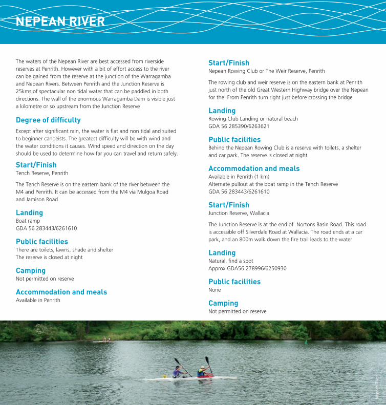
The waters of the Nepean River are best accessed from riverside reserves at Penrith. However with a bit of effort access to the river can be gained from the reserve at the junction of the Warragamba and Nepean Rivers. Between Penrith and the Junction Reserve is 25kms of spectacular non tidal water that can be paddled in both directions. The wall of the enormous Warragamba Dam is visible just a kilometre or so upstream from the Junction Reserve
Degree of difficultyExcept after significant rain, the water is flat and non tidal and suited to beginner canoeists. The greatest difficulty will be with wind and the water conditions it causes. Wind speed and direction on the day should be used to determine how far you can travel and return safely.
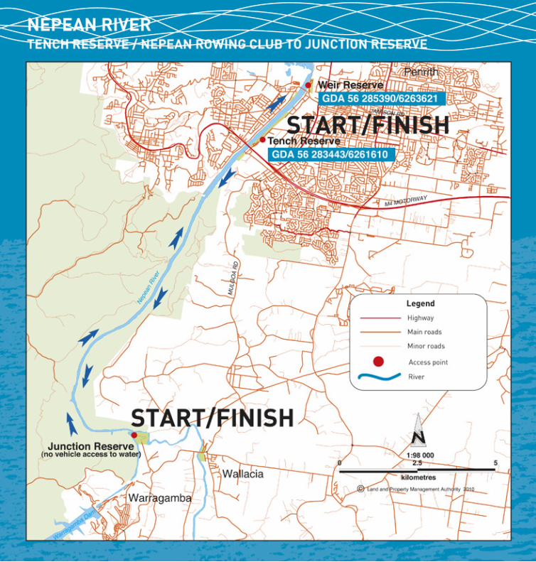
Start/FinishTench Reserve, Penrith
The Tench Reserve is on the eastern bank of the river between the M4 and Penrith. It can be accessed from the M4 via Mulgoa Road and Jamison Road
LandingBoat ramp GDA 56 283443/6261610
Public facilitiesThere are toilets, lawns, shade and shelter The reserve is closed at night
CampingNot permitted on reserve
Accommodation and mealsAvailable in Penrith
HOW TO GET THERE
Start/FinishNepean Rowing Club or The Weir Reserve, Penrith
The rowing club and weir reserve is on the eastern bank at Penrith just north of the old Great Western Highway bridge over the Nepean for the. From Penrith turn right just before crossing the bridge
LandingRowing Club Landing or natural beach GDA 56 285390/6263621
Public facilitiesBehind the Nepean Rowing Club is a reserve with toilets, a shelter and car park. The reserve is closed at night
Accommodation and mealsAvailable in Penrith (1 km) Alternate pullout at the boat ramp in the Tench Reserve GDA 56 283443/6261610
Start/FinishJunction Reserve, Wallacia
The Junction Reserve is at the end of Nortons Basin Road. This road is accessible off Silverdale Road at Wallacia. The road ends at a car park, and an 800m walk down the fire trail leads to the water
LandingNatural, find a spot Approx GDA56 278996/6250930
Public facilitiesNone
CampingNot permitted on reserve
NEPEAN RIVER
Nep
ean
Riv
er

The lower reaches of the Colo River are tidal and can be paddled in both directions with the tide. However the upper reaches are best travelled with the current ie downstream. The canoe trail is described here as if you were paddling down stream, starting at the Upper Colo Recreation Reserve and finishing at the Skeleton Rocks Reserve at Lower Portland.
Degree of difficultyAfter rain the Colo River can rise quite quickly but normally it is a slow and quite shallow in the upper reaches. The bottom is sandy and there are no rapids.
The lower sections are tidal and quite suited to beginner canoeists. It pays however to paddle with the tide. For Hawkesbury Tides see http://www.tide-times.com.au/localtime_NSW/Sydney_Northern_Beaches/Other/Hawkesbury_River_-_Gunderman.html or just Google Hawkesbury tides.
Getting to the startThe Upper Colo Recreation Reserve can be reached by vehicle from the Putty Road either by taking the Comleroy Road, or the Upper Colo Road. Both have gravel surfaces and are narrow and winding so take care.
CAUTIONThe bridge over the Colo is a low level bridge so if there has been recent rain clearance under the bridge may be reduced. Please check this as you go across. If there is not enough clearance for you and the canoe you should start your trip from below the bridge by launching from the parking area on the northern side. Otherwise proceed to the Upper Colo Reserve where there are excellent facilities.
StartUpper Colo Reserve
LandingGDA 56 289364/6299825
CampingCamping is permitted (fee payable)
FacilitiesToilets, drinking water, shelter, barbeques and tables
Vehicle accessVia Upper Colo Road and Hulberts Road
Accommodation and mealsNone locally, nearest Kurrajong, Richmond or Windsor
HOW TO GET THERECOLO RIVER
Col
o R
iver
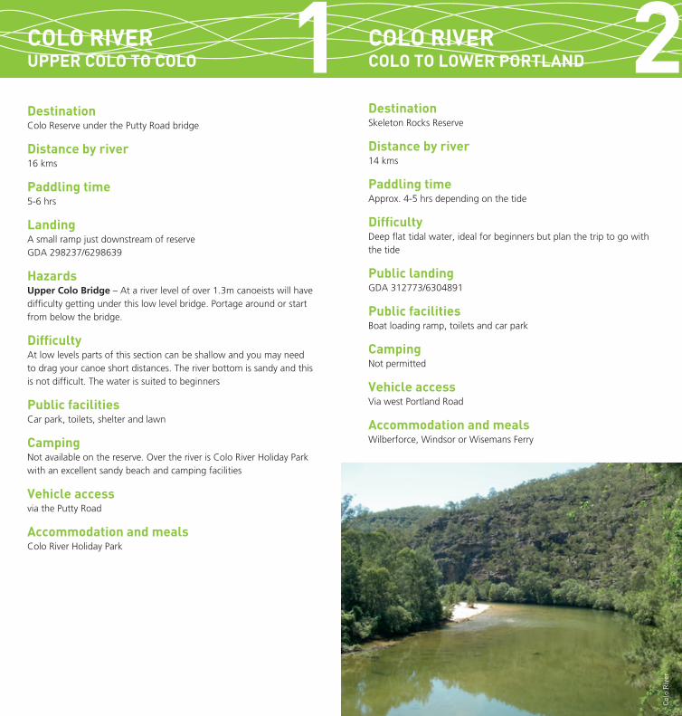
HOW TO GET THERECOLO RIVERUPPER COLO TO COLO
COLO RIVERCOLO TO LOWER PORTLAND
DestinationColo Reserve under the Putty Road bridge
Distance by river16 kms
Paddling time5-6 hrs
LandingA small ramp just downstream of reserve GDA 298237/6298639
HazardsUpper Colo Bridge – At a river level of over 1.3m canoeists will have difficulty getting under this low level bridge. Portage around or start from below the bridge.
DifficultyAt low levels parts of this section can be shallow and you may need to drag your canoe short distances. The river bottom is sandy and this is not difficult. The water is suited to beginners
Public facilitiesCar park, toilets, shelter and lawn
CampingNot available on the reserve. Over the river is Colo River Holiday Park with an excellent sandy beach and camping facilities
Vehicle accessvia the Putty Road
Accommodation and mealsColo River Holiday Park
DestinationSkeleton Rocks Reserve
Distance by river14 kms
Paddling timeApprox. 4-5 hrs depending on the tide
DifficultyDeep flat tidal water, ideal for beginners but plan the trip to go with the tide
Public landingGDA 312773/6304891
Public facilitiesBoat loading ramp, toilets and car park
CampingNot permitted
Vehicle accessVia west Portland Road
Accommodation and mealsWilberforce, Windsor or Wisemans Ferry
Col
o R
iver
1 2


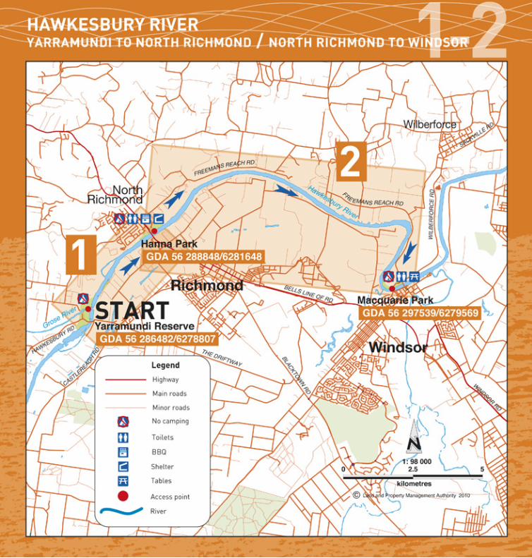
StartYarramundi Reserve
LandingPublic Beach access to River GDA 56 286482/6278807
Public facilitiesCar park, shelters, closed at night
CampingNot permitted
Vehicle accessVia Hawkesbury Road
Accommodation and mealsNearest in Richmond (5.5 kms)
Yarramundi to Wiseman’s FerryThis canoe trail can be travelled in any direction, but it is best travelled with the tide.
Tide times can be checked on http://www.tide-times.com.au/localtime_NSW/Sydney_Northern_Beaches/Other/Hawkesbury_River_-_Gunderman.html or just Google ‘Hawkesbury tides’
For the purposes of this booklet it is be described as travelling downstream.
Degree of difficultyHawkesbury River Canoe and Kayak Trail is rated as flat water. It is suited to beginner canoeists. However the river is tidal and can be affected by wind, both of which can add to the difficulty of paddling.
Beware of ski boatsThe Hawkesbury is the playground for Sydney water skiers and there are times that canoeists should avoid if they want good water, some peace and quiet and a degree of safety. The ski boats are most active during the summer months, particularly the school holidays and weekends.
Which section to paddleWhich section of the river you decide to paddle will depend on many factors. This booklet shows you the public and private access points, and the distances in between to help you plan your trip. Getting a car to the other end is also a consideration so the booklet shows the network of roads along the river. Some of these roads are narrow and winding so take care
Getting to the startYarramundi Reserve is at the junction of the Grose and Nepean Rivers.
From Sydney take the Windsor Rd to Windsor and then Richmond, then the Castlereagh Rd to Agnes Banks. Take the Hawkesbury Road across the Nepean and turn into Yarramundi Reserve.
From the Blue Mountains take the Hawkesbury Road at Springwood and turn into the Yarramundi Reserve just before crossing the Nepean River.
HOW TO GET THEREHAWKESBURY RIVER
Haw
kesb
ury
Riv
er

DestinationMacquarie Park at Windsor
Distance by river13.5 kms
Paddling time4-5 hrs
HazardsAt times there is aquatic weed in this section of the river. Ensure you wear a PDF at all times
Landing Public beach GDA 56 297539/6279569
Public facilitiesToilets, car park, shelter and tables.
CampingNot permitted
Vehicle accessImmediately across bridge on Wilberforce Road
Accommodationin Windsor (1.0 km)
MealsThere is a seafood restaurant at the reserve or meals over the bridge in Windsor
DestinationHanna Park at North Richmond
Distance by river4.0 kms
Paddling time1-2 hrs
Hazards• At times there is aquatic weed in this section of the river. Ensure
you wear a PDF at all times
• About 1.5 km from Yarramundi is a rock bar, where the water is shallow. Portage may be necessary to avoid damage
LandingBeach and jetty GDA 56 288848/6281648
Public facilitiesCar park, toilets, shelters, BBQ, lawns
CampingNot permitted
Vehicle accessVia Beaumont Ave
Accommodation and mealsIn North Richmond (1.0 km)
HOW TO GET THEREHAWKESBURY RIVERYARRAMUNDI TO NORTH RICHMOND
HAWKESBURY RIVERNORTH RICHMOND TO WINDSOR 1 2
Haw
kesb
ury
Riv
er

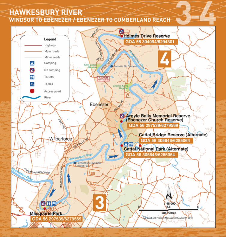
DestinationHolmes Drive Reserve
Distance by river21.5 kms
Paddling time6-7 hrs
HazardsTake care crossing the Sackville Ferry cables. Pass behind the ferry when it is moving
LandingGDA 56 304094/6294301
FacilitiesBoat ramp
CampingCamping not permitted
Vehicle accessVia Laws Farm Road and Holmes Drive
Accommodation and mealsWilberforce and Windsor
Alternate landings with accommodation and camping1. Sackville Ski Gardens, Beach, GDA 56 303254/6291756
Phone 4579 1036
DestinationEbenezer Church Reserve
Distance by river15.5 kms
Paddling time4-6 hrs
LandingBeach GDA 56 304027/6287129
FacilitiesToilets, shelters
CampingCamping not permitted
Vehicle accessVia Tizzana Road and Coromandel Road
Accommodation and mealsAt Wilberforce and Windsor
Alternate landings1. Cattai National Park, Beach, GDA 56 304069/6284806
Toilets and Camping available please book with NPWS Phone 4572 3100. Fees apply
2. Cattai Reserve. On the Cattai Creek where the Cattai Road crosses the Cattai Creek. GDA 56305646/6285064. Car park, shade, no facilities
3. Hawkesbury Riverside Tourist Park, Beach, GDA 56 300082/6283531 Phone 02 4572 3733
HOW TO GET THEREHAWKESBURY RIVERWINDSOR TO EBENEZER 3 4HAWKESBURY RIVER
EBENEZER TO CUMBERLAND REACH
Haw
kesb
ury
Riv
er
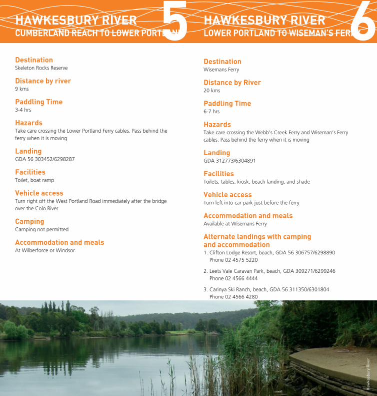
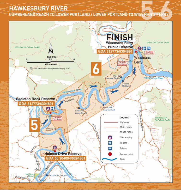
DestinationSkeleton Rocks Reserve
Distance by river9 kms
Paddling Time3-4 hrs
HazardsTake care crossing the Lower Portland Ferry cables. Pass behind the ferry when it is moving
LandingGDA 56 303452/6298287
FacilitiesToilet, boat ramp
Vehicle accessTurn right off the West Portland Road immediately after the bridge over the Colo River
CampingCamping not permitted
Accommodation and mealsAt Wilberforce or Windsor
HOW TO GET THEREHAWKESBURY RIVERCUMBERLAND REACH TO LOWER PORTLAND5
DestinationWisemans Ferry
Distance by River20 kms
Paddling Time6-7 hrs
HazardsTake care crossing the Webb’s Creek Ferry and Wiseman’s Ferry cables. Pass behind the ferry when it is moving
LandingGDA 312773/6304891
FacilitiesToilets, tables, kiosk, beach landing, and shade
Vehicle accessTurn left into car park just before the ferry
Accommodation and mealsAvailable at Wisemans Ferry
Alternate landings with camping and accommodation1. Clifton Lodge Resort, beach, GDA 56 306757/6298890
Phone 02 4575 5220
2. Leets Vale Caravan Park, beach, GDA 309271/6299246 Phone 02 4566 4444
3. Carinya Ski Ranch, beach, GDA 56 311350/6301804 Phone 02 4566 4280
4. Del Rio Riverside Resort, Beach, GDA 56 311167/6302081 Phone 02 4566 4330
6HAWKESBURY RIVERLOWER PORTLAND TO WISEMAN’S FERRY
Haw
kesb
ury
Riv
er
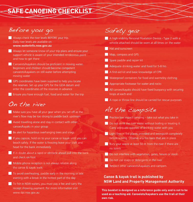
Before you go Always check the river levels BEFORE your trip. Daily river levels are available on www.waterinfo.nsw.gov.au
Always let someone know of your trip plans and ensure your support vehicle is aware of your intended rendezvous point and how to get there
Canoeists/kayakers should be proficient in moving water. Beginners and children should become competent canoeists/kayakers on still water before attempting moving water
GPS coordinates have been supplied to help you locate the reserves. Set up your GPS for the GDA datum and enter the coordinates of the reserves in advance
Ensure you have enough fuel, food and water for the trip
On the river Make sure you have all your gear when you set off as the
river’s flow may be too strong to paddle back upstream
Avoid travelling alone and stay in contact with other
canoes/kayaks in your group
Be alert for hazardous overhanging trees and snags
If you capsize, hold on to your canoe or kayak until you can
beach safely. If the water is freezing leave your craft and
head for the bank immediately
If in doubt about a rapid or obstacle ahead pull into the bank
and check on foot
Mobile phone reception is not always reliable along
the canoe & kayak trails
To avoid overheating, paddle early in the morning or late
evening with a break in the hottest part of the day
To fish in NSW waters, you must pay a fee and carry the
receipt showing payment. For more information visit
www.dpi.nsw.gov.au
SAFE CANOEING CHECKLIST
Safety gear A high visibility Personal Floatation Device - Type 2 with a
whistle attached should be worn at all times on the water
Hat and sunscreen
Map, compass and GPS
Spare paddle and repair kit
Adequate drinking water and food for 5-8 hrs
A first-aid kit and basic knowledge of CPR
Waterproof containers for food and warm/dry clothing
Appropriate footwear for water and rocks
All canoes/kayaks should have fixed buoyancy with securing
loops at each end
A rope or throw line should be carried for rescue purposes
At the campsite Practice low impact camping – take out what you take in
Do not drink the river water without boiling or treating it.
Carry adequate supplies of drinking water with you
Light fires in fire places provided and extinguish completely
before leaving. Observe any fire bans that are in place
Bury your waste at least 50 m from the river if there are
no toilets
Do not interfere with vegetation, gates, fences or stock
Do not use soaps or detergents in the river
Respect other canoeists/kayakers and campers
This booklet is designed as a reference guide only and is not to be used as a teaching aid. Canoeists/kayakers use the trail at their own risk.
Canoe & kayak trail is published by NSW Land and Property Management Authority
© February 2010 NSW Land and Property Management Authority (B) P10/06/011
Images have been selected for marketing and communication purposes only and may or may not be indicative of Crown land. Information is correct at time of printing.
Land and Property Management Authority
Head office
1 Prince Albert Road
Queens Square
SYDNEY NSW 2000
T 1300 052 637
61 2 9228 6666
F 61 2 9233 4357www.lpma.nsw.gov.au
For other great holiday ideas visit www.lpma.nsw.gov.au
Haw
kesb
ury
Riv
er