hancock mfl memo nov2003 - southwest florida water ... · hancock lake (figure 1) is located in the...
TRANSCRIPT
DRAFT 1 of 15
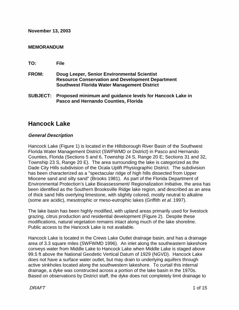
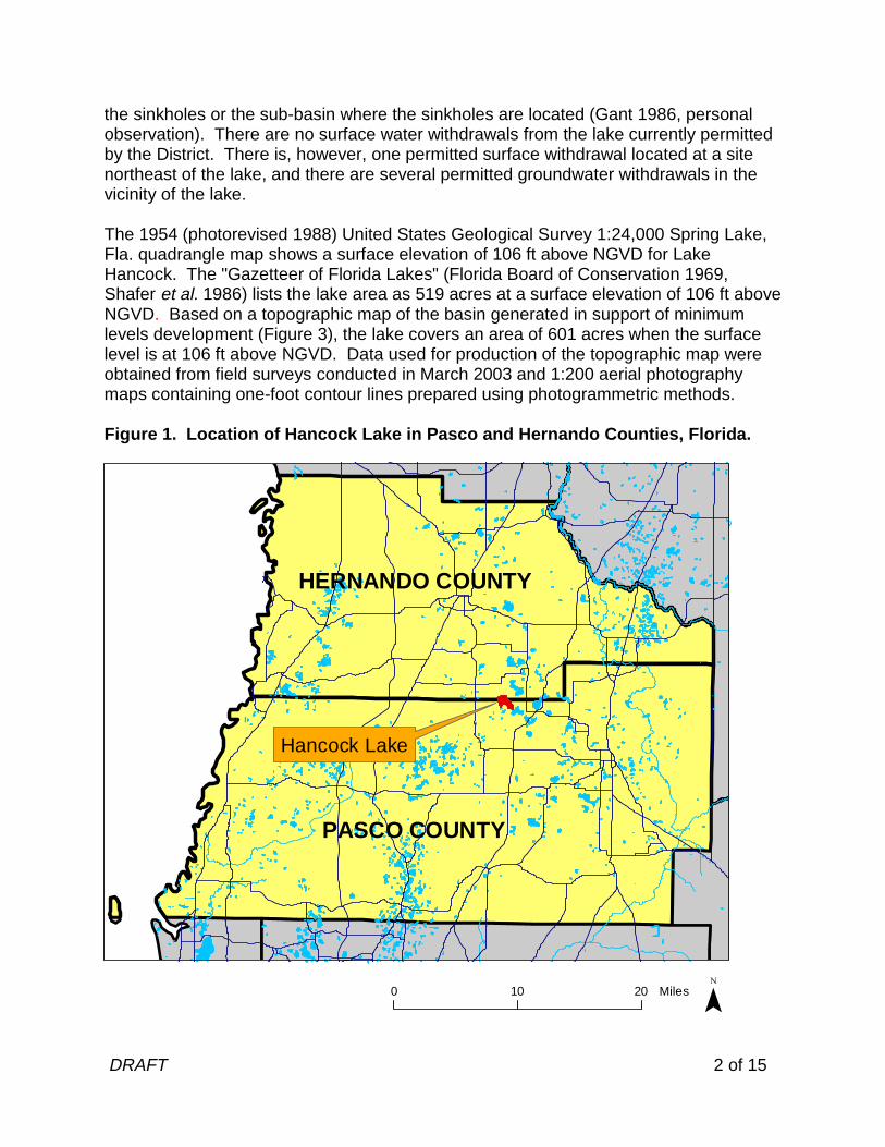
November 13, 2003 MEMORANDUM TO: File FROM: Doug Leeper, Senior Environmental Scientist Resource Conservation and Development Department Southwest Florida Water Management District SUBJECT: Proposed minimum and guidance levels for Hancock Lake in Pasco and Hernando Counties, Florida Hancock Lake General Description Hancock Lake (Figure 1) is located in the Hillsborough River Basin of the Southwest Florida Water Management District (SWFWMD or District) in Pasco and Hernando Counties, Florida (Sections 5 and 6, Township 24 S, Range 20 E; Sections 31 and 32, Township 23 S, Range 20 E). The area surrounding the lake is categorized as the Dade City Hills subdivision of the Ocala Uplift Physiographic District. The subdivision has been characterized as a "spectacular ridge of high hills dissected from Upper Miocene sand and silty sand" (Brooks 1981). As part of the Florida Department of Environmental Protection’s Lake Bioassessment/ Regionalization Initiative, the area has been identified as the Southern Brooksville Ridge lake region, and described as an area of thick sand hills overlying limestone, with slightly colored, mostly neutral to alkaline (some are acidic), mesotrophic or meso-eutrophic lakes (Griffith et al. 1997). The lake basin has been highly modified, with upland areas primarily used for livestock grazing, citrus production and residential development (Figure 2). Despite these modifications, natural vegetation remains intact along much of the lake shoreline. Public access to the Hancock Lake is not available. Hancock Lake is located in the Crews Lake Outlet drainage basin, and has a drainage area of 3.3 square miles (SWFWMD 1996). An inlet along the southeastern lakeshore conveys water from Middle Lake to Hancock Lake when Middle Lake is staged above 99.5 ft above the National Geodetic Vertical Datum of 1929 (NGVD). Hancock Lake does not have a surface water outlet, but may drain to underlying aquifers through active sinkholes located along the southwestern lakeshore. To curtail this internal drainage, a dyke was constructed across a portion of the lake basin in the 1970s. Based on observations by District staff, the dyke does not completely limit drainage to
DRAFT 2 of 15
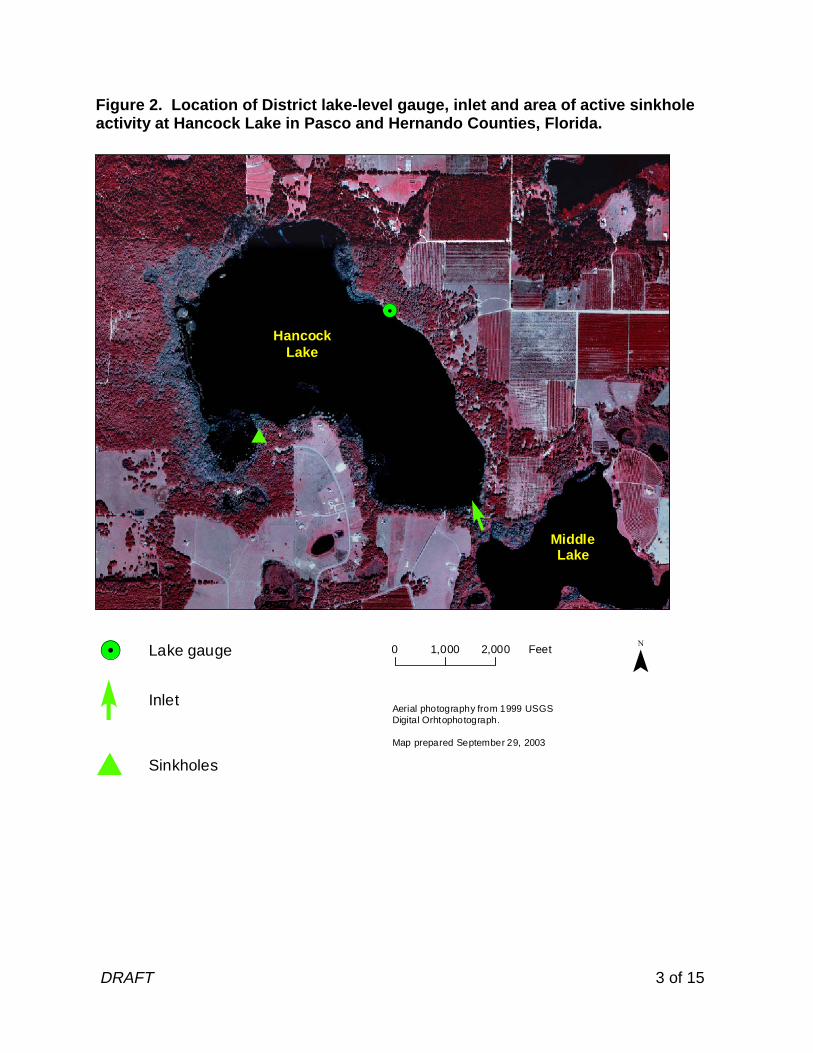
the sinkholes or the sub-basin where the sinkholes are located (Gant 1986, personal observation). There are no surface water withdrawals from the lake currently permitted by the District. There is, however, one permitted surface withdrawal located at a site northeast of the lake, and there are several permitted groundwater withdrawals in the vicinity of the lake. The 1954 (photorevised 1988) United States Geological Survey 1:24,000 Spring Lake, Fla. quadrangle map shows a surface elevation of 106 ft above NGVD for Lake Hancock. The "Gazetteer of Florida Lakes" (Florida Board of Conservation 1969, Shafer et al. 1986) lists the lake area as 519 acres at a surface elevation of 106 ft above NGVD. Based on a topographic map of the basin generated in support of minimum levels development (Figure 3), the lake covers an area of 601 acres when the surface level is at 106 ft above NGVD. Data used for production of the topographic map were obtained from field surveys conducted in March 2003 and 1:200 aerial photography maps containing one-foot contour lines prepared using photogrammetric methods. Figure 1. Location of Hancock Lake in Pasco and Hernando Counties, Florida.
0 10 20 Miles
PASCO COUNTY
HERNANDO COUNTY
Hancock Lake
DRAFT 3 of 15
Figure 2. Location of District lake-level gauge, inlet and area of active sinkhole activity at Hancock Lake in Pasco and Hernando Counties, Florida.
Sinkholes#
0 1,000 2,000 Feet
Aerial photography from 1999 USGSDigital Orhtophotograph.
Map prepared September 29, 2003
Inlet
Lake gauge!.
HancockLake
MiddleLake
!.
#
DRAFT 4 of 15
Figure 3. One-foot contours within the Hancock Lake basin in Pasco and Hernando Counties, Florida. Values shown are elevations, in feet above the National Geodetic Vertical Datum of 1929.
0 1,000 2,000 FeetMap prepared July 17, 2003 using 1999 USGS digital orthophotography, elevation data from 1987 SWFWMD aerial photography with contours maps (Sheet Nos 05-24-20,06-24-20, 31-23-20 and 32-23-20), and elevation data collected on March 13 and 18, 2003 by SWFWMD Staff.
98
99
103108
105
91
109
92
9594
96
93
90
97
101
104107 102
106
100
96
93
100
96
102
107
103
104
108
102
93
96
94
108
104
93
93
107
95
95
91
101
97
98
94
98
109
95
94
99
101
98
102
109
101106
96
92
96
109
103
97
109
97
95
103
107
109
97
92
102
106
108
103
97
94
98
107
93
108
104
95
104107
92
108
97
103
106
96
103
96
102
106
108
100
91
105
108
106
93
98
98
97
97
104
102
96
97
91
93
9795
109
96
107
94
96
103
101
109
94
104
105
94
94
98
107
101
108
104
102
96
105
103
94
95
10197
94
93
101
96
97
93
95
95
99
108
94
104
95
93
95
98
103
98108
99
106
95
109
107
107
99
94
108
92
108
108
99
108
109
92
95
94
107
98
105
96
98
101
108
102
98
109
96
96
101
106 106
101
99
94
93
96
95
90
95
94
96
100
109
105
99
95
94
95
9695
91
108
99
94
102
105
93
96
109
94100
104
93
91109
105
98
103
105
100
92
99
103
92
95
10294
105
108
96
109
103
108
110
110
110
110
DRAFT 5 of 15
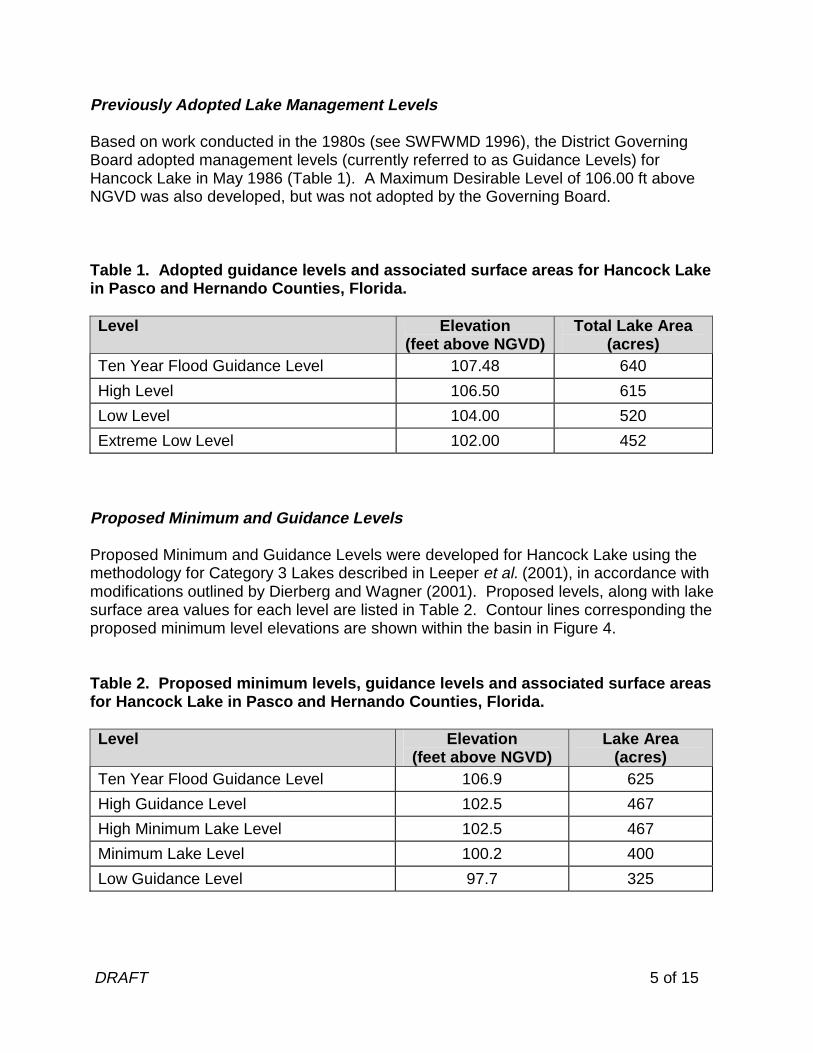
Previously Adopted Lake Management Levels Based on work conducted in the 1980s (see SWFWMD 1996), the District Governing Board adopted management levels (currently referred to as Guidance Levels) for Hancock Lake in May 1986 (Table 1). A Maximum Desirable Level of 106.00 ft above NGVD was also developed, but was not adopted by the Governing Board. Table 1. Adopted guidance levels and associated surface areas for Hancock Lake in Pasco and Hernando Counties, Florida. Level Elevation
(feet above NGVD)Total Lake Area
(acres) Ten Year Flood Guidance Level 107.48 640
High Level 106.50 615
Low Level 104.00 520
Extreme Low Level 102.00 452 Proposed Minimum and Guidance Levels Proposed Minimum and Guidance Levels were developed for Hancock Lake using the methodology for Category 3 Lakes described in Leeper et al. (2001), in accordance with modifications outlined by Dierberg and Wagner (2001). Proposed levels, along with lake surface area values for each level are listed in Table 2. Contour lines corresponding the proposed minimum level elevations are shown within the basin in Figure 4. Table 2. Proposed minimum levels, guidance levels and associated surface areas for Hancock Lake in Pasco and Hernando Counties, Florida. Level Elevation
(feet above NGVD) Lake Area
(acres) Ten Year Flood Guidance Level 106.9 625
High Guidance Level 102.5 467
High Minimum Lake Level 102.5 467
Minimum Lake Level 100.2 400
Low Guidance Level 97.7 325
DRAFT 6 of 15
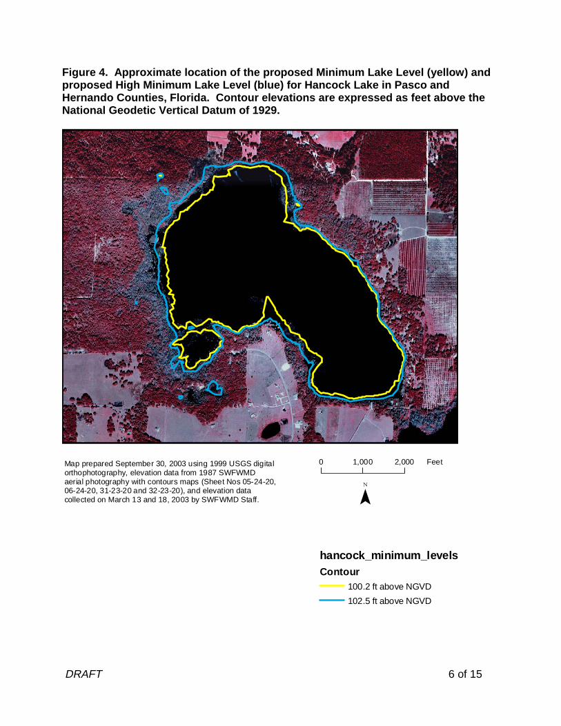
Figure 4. Approximate location of the proposed Minimum Lake Level (yellow) and proposed High Minimum Lake Level (blue) for Hancock Lake in Pasco and Hernando Counties, Florida. Contour elevations are expressed as feet above the National Geodetic Vertical Datum of 1929.
hancock_minimum_levelsContour
100.2 ft above NGVD
102.5 ft above NGVD
0 1,000 2,000 FeetMap prepared September 30, 2003 using 1999 USGS digital orthophotography, elevation data from 1987 SWFWMD aerial photography with contours maps (Sheet Nos 05-24-20,06-24-20, 31-23-20 and 32-23-20), and elevation data collected on March 13 and 18, 2003 by SWFWMD Staff.
DRAFT 7 of 15
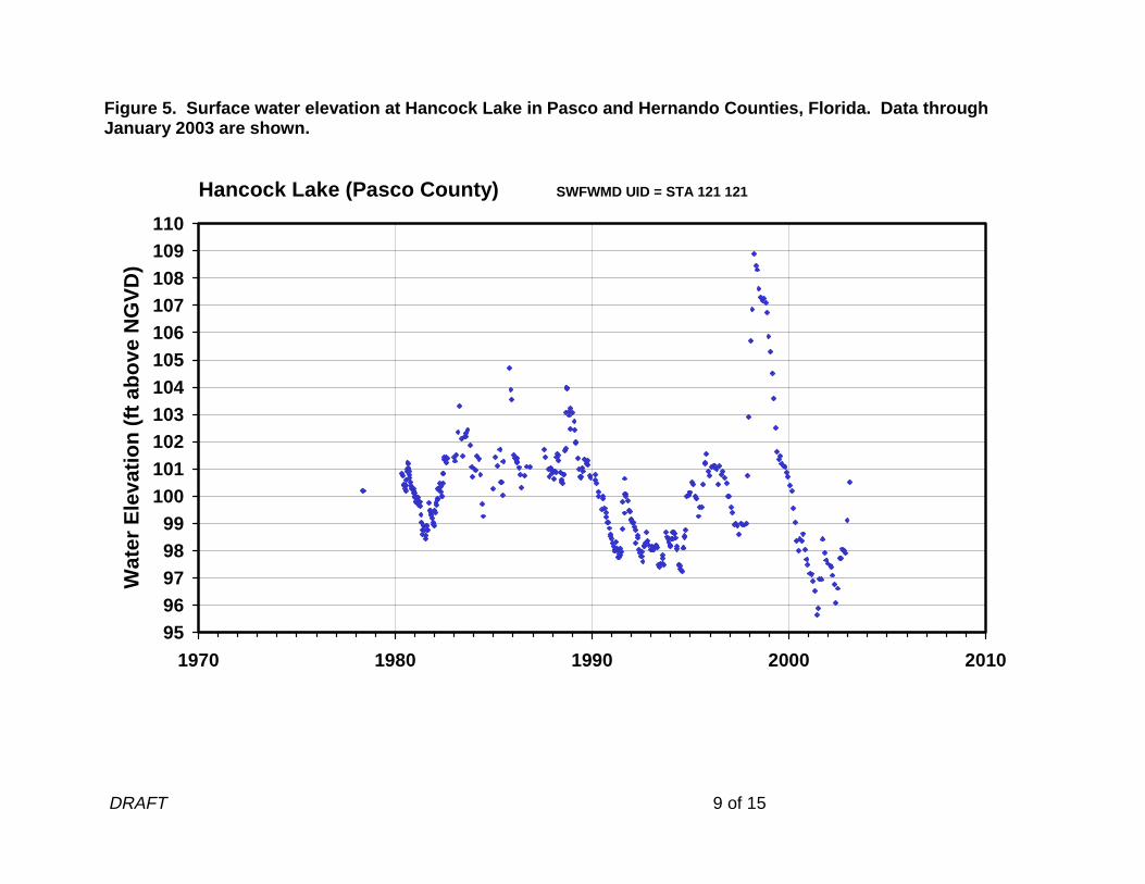
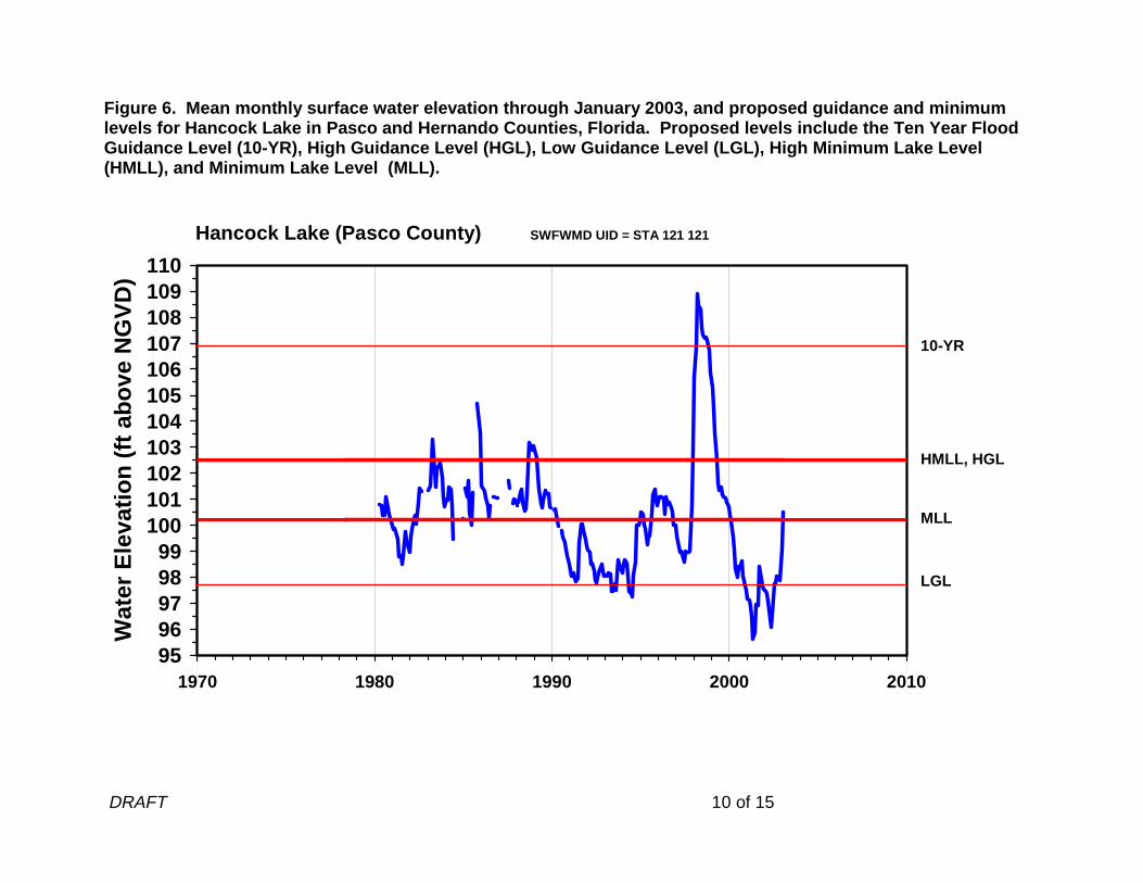
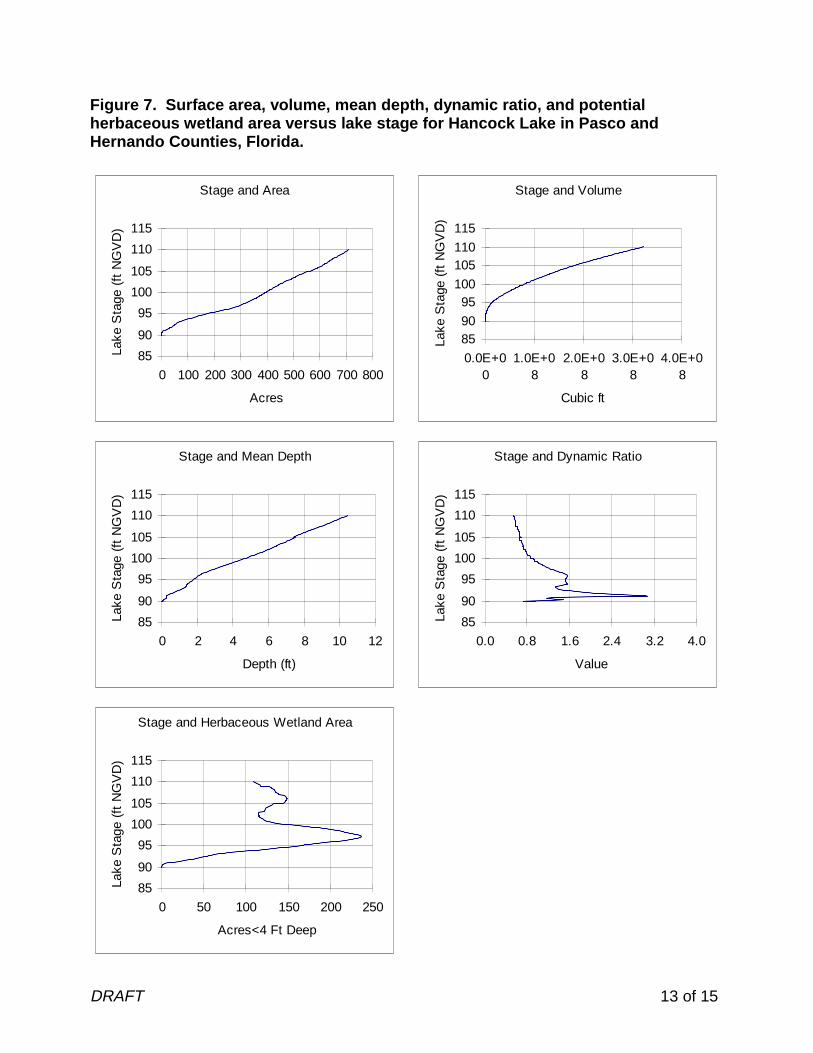
Summary of Data and Analyses Supporting Recommended Minimum and Guidance Levels Hydrologic data are available for Hancock Lake (District Universal ID Number STA 121 121) from May 1978, from April 1980 through August 1982, and from January 1983 to the present date (Figure 5; see Figure 2 for current location of the SWFWMD lake-level gauge). Monthly mean water surface elevations, along with proposed guidance and minimum levels are shown in Figure 6. For the entire period of record, the hydrologic data are classified as Historic data. Historic data collected through January 2003 were used to calculate the Historic P10, P50, and P90 (Table 3). Based on the availability of Historic hydrologic data for the lake basin, the High Guidance Level was established at the Historic P10 elevation (102.5 ft above NGVD). Historic hydrologic data were also used to establish the Historic P50 elevation (100.2 ft above NGVD) and the Low Guidance Level (97.7 ft above NGVD). A Category 3 Lake Normal Pool elevation was not established for Hancock Lake. The elevation would be expected to occur in the range of 103 to 110 ft above NGVD, based on elevations associated with the distribution of live oak (Quercus virginiana) and other canopy species (Table 4). Establishment of the Category 3 Lake normal pool elevation was not critical for development of lake levels, as Historic data were available for determination of the High Guidance Level. The low floor slab elevation and extent of structural alteration were determined using available one-foot contour interval aerial maps and field survey data (Table 3). Because Hancock Lake does not have a surface water outlet, a control point was not established and the lake was classified as a closed basin lake. The Ten Year Flood Guidance Level for Lake Hancock was established at 106.9 ft NGVD using the methodology for closed basin lakes described in current District Rules (Chapter 40D-8, Florida Administrative Code). In accordance with the closed-basin methodology, the 10-year flood level was based on frequency analysis of the lake stage values derived from a HSPF (Hydrologic Simulation Program Fortran) continuous simulation model and the available gauging record. Inputs to the model included standard watershed parameters (basin size, slope, infiltration rate, ground water recession rate, etc.) and rainfall records from the Brooksville National Weather Service site for the period from 1950 through 2003. Based on available stage data, the Ten Year Flood Guidance Level was last exceeded during the late 1990s (see Figure 5). The highest surface elevation for Hancock Lake included in the District Water Management Database, 108.9 ft above NGVD, occurred on March 26, 1998. The low of record, 95.64 ft above NGVD, occurred on March 31, 2001. Aquatic macrophytes, including cattail (Typha sp.), pickerelweed (Pontederia cordata), fragrant water lily (Nymphaea odorata), banana lily (Nymphoides aquatica), milfoil (Myriophyllum sp.), burhead sedge (Scirpus cubensis), water hyacinth (Eichhornia crassipes), pennywort (Hydrocotyle umbellata), hydrilla (Hydrilla verticillata), and willow
DRAFT 8 of 15
(Salix sp.) occur throughout the basin. The lake is not, however, contiguous with cypress-dominated wetlands of 0.5 or more acres in size and is therefore classified as a Category 3 Lake for the purpose of minimum levels development. Dock-Use, Basin Connectivity, Recreation/Ski, Species Richness, Aesthetics and Mixing Standards were evaluated for minimum levels development (Table 3). The Dock-Use Standard was established at 102.3 ft above NGVD, based on the elevation of sediments at the end of ninety percent of the 10 docks at the lake (97.9 ft above NGVD, Table 4), a clearance value of 2 ft based on use of powerboats in the lake, and the difference between the Historic P50 and Historic P90 elevations (2.4 ft). The Basin Connectivity Standard was established at 100.9 ft above NGVD, based on the elevation that ensures connectivity among the major lake sub-basins (96.5 ft above NGVD), a clearance value of 2 ft for use of power boats on the lake and the difference between the Historic P50 and Historic P90 elevations (2.4 ft). The Basin Connectivity Standard was developed to ensure connectivity among the major lake sub-basins, but not between the major lake sub-basins and the southwestern sub-basin, which is the site of active sinkhole activity. The Recreation/Ski Standard was established at 100.4 ft above NGVD, based on the elevation at which the lake could contain a safe skiing area with a depth of five-feet (98 ft above NGVD) and the difference between the Historic P50 and Historic P90 (2.4 ft). The Species Richness Standard was established at 98.2 ft above NGVD, based on limiting change in lake surface area to less than a 15% reduction from the area at the Historic P50 elevation. The Aesthetic-Standard for the lake was established at the Low Guidance Level elevation of 97.7 ft above NGVD. Based on review of dynamic ratio values for lake stages up to the Historic P50 elevation (see Figure 7), a Mixing Standard was not established for the lake. Review of changes in potential herbaceous wetland area associated with change in lake stage, and potential change in area available for aquatic macrophyte colonization did not indicate that use of any of the identified standards would be inappropriate for minimum levels development (Figure 7). Because the Recreation/Ski Standard exceeds the Historic P50 elevation, the standard is not considered appropriate for minimum levels development. The Dock-Use Standard, the most conservative (i.e., the highest) of the appropriate standards, is greater than the Historic P50 elevation, so the Historic P50 was used to establish the proposed Minimum Lake Level at 100.2 ft above NGVD. The proposed High Minimum Lake Level was established at 102.5 ft above NGVD, an elevation corresponding to the Minimum Lake Level plus the difference between the Historic P10 and the Historic P50 (2.3 ft). The proposed High Minimum Lake Level is 2.7 ft below the Low Floor Slab elevation and 3.5 ft below the lowest paved road in the immediate lake basin.
DRAFT 9 of 15
Figure 5. Surface water elevation at Hancock Lake in Pasco and Hernando Counties, Florida. Data through January 2003 are shown.
9596979899
100101102103104105106107108109110
1970 1980 1990 2000 2010
Wat
er E
leva
tio
n (
ft a
bo
ve N
GV
D)
Hancock Lake (Pasco County) SWFWMD UID = STA 121 121
DRAFT 10 of 15
Figure 6. Mean monthly surface water elevation through January 2003, and proposed guidance and minimum levels for Hancock Lake in Pasco and Hernando Counties, Florida. Proposed levels include the Ten Year Flood Guidance Level (10-YR), High Guidance Level (HGL), Low Guidance Level (LGL), High Minimum Lake Level (HMLL), and Minimum Lake Level (MLL).
9596979899
100101102103104105106107108109110
1970 1980 1990 2000 2010
Wat
er E
leva
tio
n (
ft a
bo
ve N
GV
D)
MLL
10-YR
HMLL, HGL
LGL
Hancock Lake (Pasco County) SWFWMD UID = STA 121 121
DRAFT 11 of 15
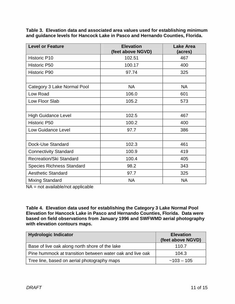
Table 3. Elevation data and associated area values used for establishing minimum and guidance levels for Hancock Lake in Pasco and Hernando Counties, Florida. Level or Feature Elevation
(feet above NGVD) Lake Area
(acres) Historic P10 102.51 467
Historic P50 100.17 400
Historic P90 97.74 325
Category 3 Lake Normal Pool NA NA
Low Road 106.0 601
Low Floor Slab 105.2 573
High Guidance Level 102.5 467
Historic P50 100.2 400
Low Guidance Level 97.7 386
Dock-Use Standard 102.3 461
Connectivity Standard 100.9 419
Recreation/Ski Standard 100.4 405
Species Richness Standard 98.2 343
Aesthetic Standard 97.7 325
Mixing Standard NA NA NA = not available/not applicable Table 4. Elevation data used for establishing the Category 3 Lake Normal Pool Elevation for Hancock Lake in Pasco and Hernando Counties, Florida. Data were based on field observations from January 1996 and SWFWMD aerial photography with elevation contours maps. Hydrologic Indicator Elevation
(feet above NGVD) Base of live oak along north shore of the lake 110.7
Pine hummock at transition between water oak and live oak 104.3
Tree line, based on aerial photography maps ~103 – 105
DRAFT 12 of 15
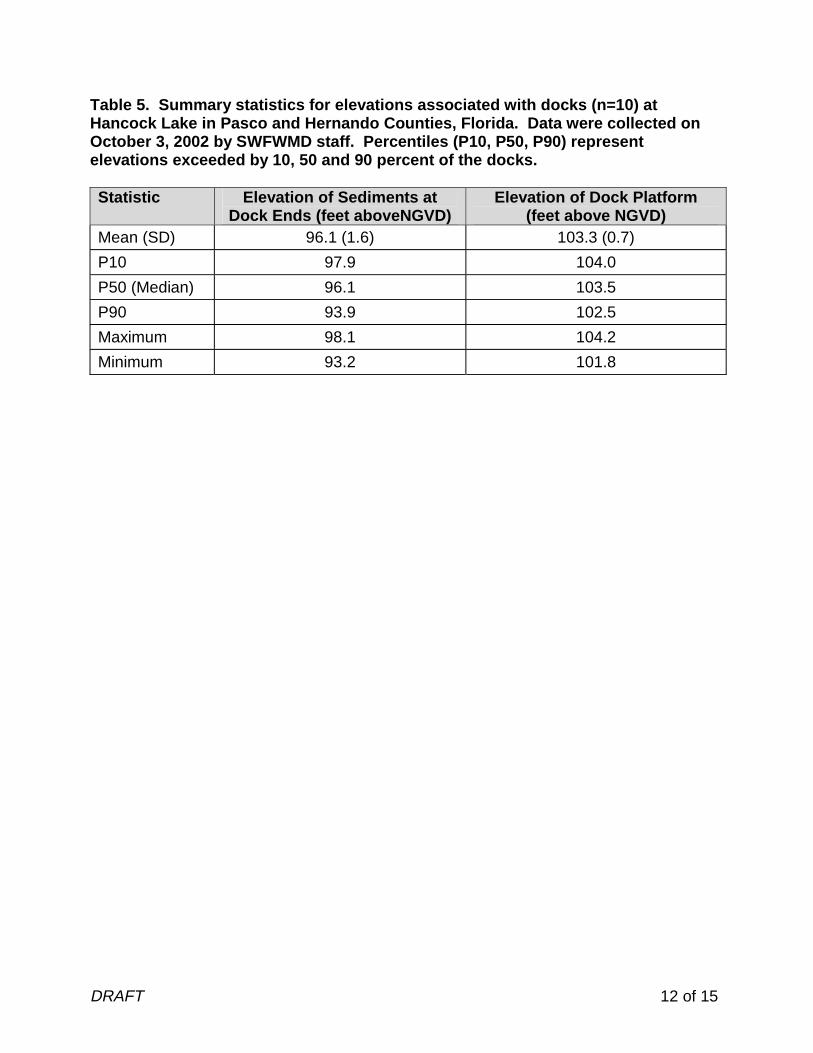
Table 5. Summary statistics for elevations associated with docks (n=10) at Hancock Lake in Pasco and Hernando Counties, Florida. Data were collected on October 3, 2002 by SWFWMD staff. Percentiles (P10, P50, P90) represent elevations exceeded by 10, 50 and 90 percent of the docks. Statistic Elevation of Sediments at
Dock Ends (feet aboveNGVD) Elevation of Dock Platform
(feet above NGVD) Mean (SD) 96.1 (1.6) 103.3 (0.7)
P10 97.9 104.0
P50 (Median) 96.1 103.5
P90 93.9 102.5
Maximum 98.1 104.2
Minimum 93.2 101.8
DRAFT 13 of 15
Figure 7. Surface area, volume, mean depth, dynamic ratio, and potential herbaceous wetland area versus lake stage for Hancock Lake in Pasco and Hernando Counties, Florida.
Stage and Area
85
90
95
100
105
110
115
0 100 200 300 400 500 600 700 800
Acres
Lake
Sta
ge (
ft N
GV
D)
Stage and Volume
8590
95100
105110
115
0.0E+00
1.0E+08
2.0E+08
3.0E+08
4.0E+08
Cubic ft
Lake
Sta
ge (
ft N
GV
D)
Stage and Mean Depth
85
90
95
100
105
110
115
0 2 4 6 8 10 12
Depth (ft)
Lake
Sta
ge (
ft N
GV
D)
Stage and Dynamic Ratio
85
90
95
100
105
110
115
0.0 0.8 1.6 2.4 3.2 4.0
Value
Lake
Sta
ge (
ft N
GV
D)
Stage and Herbaceous Wetland Area
85
90
95
100
105
110
115
0 50 100 150 200 250
Acres<4 Ft Deep
Lake
Sta
ge (
ft N
GV
D)

DRAFT 14 of 15
Documents Cited and Reviewed for Development of Proposed Guidance and Minimum Levels Bachmann, R. W., Hoyer, M. V., and Canfield, D. E., Jr. 2000. The potential for wave disturbance in shallow Florida lakes. Lake and Reservoir Management 16: 281-291. Brooks, H. K. 1981. Physiographic divisions of Florida: map and guide. Cooperative Extension Service, Institute of Food and Agricultural Sciences, University of Florida, Gainesville, Florida. Dierberg, F. E. and Wagner, K. J. 2001. A review of “A multiple-parameter approach for establishing minimum levels for Category 3 Lakes of the Southwest Florida Water Management District” June 2001 draft by D. Leeper, M. Kelly, A. Munson, and R. Gant. Prepared for the Southwest Florida Water Management District. Brooksville, Florida. Dooris, P. M. 1986. Letter to Mr. Stephen L. Peacock, dated May 7, 1986, regarding Lakes Hancock and Middle, Pasco County. Southwest Florida Water Management District, Brooksville, Florida. Florida Board of Conservation. 1969. Florida lakes, part III: gazetteer. Division of Water Resources. Tallahassee, Florida. Gant, R. D. 1986. Memorandum to CUP File 204290, Cross Bar Wellfield, dated January 20, 1986, regarding sinkholes in Lake Hancock – Pasco County, Section 5, Township 24, Range 20. Southwest Florida Water Management District, Brooksville, Florida. Griffith, G., Canfield, D., Jr., Horsburgh, C., Omernik, and J. Azevedo, S. 1997. Lake regions of Florida (map). United States Environmental Protection Agency, University of Florida Institute of Food and Agricultural Sciences, Florida Lakewatch, Florida Department of Environmental Protection, and the Florida Lake Management Society. Gainesville and Tallahassee, Florida. Leeper, D., Kelly, M., Munson, A. and Gant, R. 2001. A multiple-parameter approach for establishing minimum levels for Category 3 Lakes of the Southwest Florida Water Management District, June14, 2001 draft. Southwest Florida Water Management District. Brooksville, Florida. Romie, K. 2000. Water chemistry of lakes in the Southwest Florida Water Management District. Brooksville, Florida. Shafer, M. D., Dickinson, R. E., Heaney, J. P., and Huber, W. C. 1986. Gazetteer of Florida lakes. Publication no. 96, Water Resources Research Center, University of Florida. Gainesville, Florida.
DRAFT 15 of 15
Southwest Florida Water Management District. 1987. Hillsborough River Basin, Moody Lake, aerial photography with contours. Sheet No. 05-24-20. Brooksville, Florida. Prepared by Hamrick Aerial Surveys. Clearwater, Florida. Southwest Florida Water Management District. 1987. Hillsborough River Basin, Moody Lake, aerial photography with contours. Sheet No. 06-24-20. Brooksville, Florida. Prepared by Hamrick Aerial Surveys. Clearwater, Florida. Southwest Florida Water Management District. 1987. Hillsborough River Basin, Moody Lake, aerial photography with contours. Sheet No. 31-23-20. Brooksville, Florida. Prepared by Hamrick Aerial Surveys. Clearwater, Florida. Southwest Florida Water Management District. 1987. Hillsborough River Basin, Moody Lake, aerial photography with contours. Sheet No. 32-23-20. Brooksville, Florida. Prepared by Hamrick Aerial Surveys. Clearwater, Florida. Southwest Florida Water Management District. 1996. Survey Section Field Book 13.321, p. 41. Brooksville, Florida. Southwest Florida Water Management District. 2003 Lake Levels Program lake data sheets / 1977-1996, Hillsborough River Basin – 13. Brooksville, Florida. United States Geological Survey. 1954. Spring Lake quadrangle, Florida, 7.5 minute series (topographic) map; Spring Lake, Fla., 29082-D3-TF-024, 1954, photorevised 1988, DMA 4540 IV NE-Series V847. Department of Interior. Washington, D.C. Vomacka, J. G. 1986. Memorandum to D. F. Richters, dated January 7, 1986, regarding inverts on Lakes Moody, Middle and Hancock. Southwest Florida Water Management District, Brooksville, Florida.