guidelines on real property units and identifiers … · real property units and identifiers ......
TRANSCRIPT

ECONOMIC COMMISSION FOR EUROPE
Geneva
GUIDELINES
ON
REAL PROPERTY UNITS AND IDENTIFIERS
UNITED NATIONS New York and Geneva, 2004
Guidelines on Real Property Units
NOTE
Symbols of United Nations documents are composed of capital letters combined with figures. Mention of such symbols indicates a reference to a United Nations document.
The designations employed and the presentation of the material in this publication do not imply the expression of any opinion whatsoever on the part of the Secretariat of the United Nations concerning the legal status of any country, territory, city or area, or its authorities, or concerning the delimitation of its frontiers or boundaries.
ECE/HBP/135
Copyright ® United Nations, 2004 All rights reserved
UNECE Information Service Phone: +41 (0) 22 917 44 Palais des Nations Fax: +41 (0) 22 917 05 05 CH-1211 Geneva 10 E-mail: info.ecenece.org Switzerland Web site: http://www.unece.org
ii
Guidelines on Real Property Units
CONTENTS Page
Contents iii Foreword v Preface vii Executive summary ix Country abbreviations xii
PART ONE
Chapter
I. THE BACKGROUND TO LAND ADMINISTRATION
A. Land and its social and economic importance 1 B. Cadastres and land registration systems 2 C. The scope of land administration 5 D. The land market 6
II. THE NATURE OF REAL PROPERTY
A. Property and property rights 8 B. Ownership and possession of land 9 C. Rights in real property 9 D. Tenures 11
III. THE THIRD DIMENSION
A. Land versus buildings 12 B. Rights in condominiums 13 C. Rights to minerals and hydrocarbons 14 D. Rights to water 14
IV. LAND USE AND LAND USE RIGHTS
A. The definitions of land use 16 B. Land-use controls and physical planning 18 C. The integrated administration and control system 19
PART TWO
V. REAL PROPERTY UNITS
A. Determining ownership 21 B. Units of real property 22 C. Multiple parcels and multiple owners 26 D. Fragmentation of areas 27 E. Boundaries 29
iii

Guidelines on Real Property Units
VI. IDENTIFIERS
A. Cadastral identifiers 32 B. Building and apartment identifiers 35 C. Cadastral plans 37 D. Street addresses and postcodes 41 E. Geographic references 43
VII. APPLICATIONS OF REAL PROPERTY IDENTIFIERS
A. Postcode geographies 46 B. Location-based services 47
PART THREE
VIII. CONCLUSIONS AND RECOMMENDATIONS
A. Principles to be followed 50 B. Suggestions and recommendations 55
ANNEXES
I. Glossary 57 II. Example of information in a real property register 65
LIST OF FIGURES I. Perspectives on land II. Cadastre / land registration overlap III. Wealth improvement through the land market IV. Rights exist below, on or above the land V. Parcels and basic property units VI. Plots VII. The hierarchy of ownership VIII. Fragmentation IX. Extract from a cadastral map of a rural area in Finland X. Extract from an urban cadastral plan with topographic data XI. Part of an Austrian cadastral map XII. Extract from a city cadastral plan in Lithuania XIII. Section of an Austrian cadastral map with soils boundaries overlaid XIV. The coordinates of the centre of a building XV. Divisions by postcode XVI. Divisions by grid square XVII. Urban plan of Elefsis, Greece XVIII. 3D perspective representations of the area shown in figure XVIII
References and additional material 68
iv

Guidelines on Real Property Units
FOREWORD
Land administration and land-related policies are fundamental to good governance, sustainable economic growth, social cohesion and security, and the well-being of and the economic opportunities open to urban and rural populations. In 1993 the United Nations Economic Commission for Europe (UNECE) launched an initiative to strengthen land administration capabilities, mainly for countries in Eastern and Central Europe. The main purpose was to identify their needs and problems related to land administration, and for experts both from countries in transition and from the West to share views and experiences. UNECE also sought to assess the opportunities for applying land administration methods, policies and procedures similar to those that had evolved over a long period of time in the market economies of the UNECE region. In 1996, UNECE published the Guidelines on Land Administration with special reference to countries in transition (ECE/HBP/96). These Guidelines defined land administration as the process whereby land and the information about land may be effectively managed. They are written mainly for senior governmental staff and politicians engaged in land administration issues. The aim was to outline the social and economic benefits of having a relevant and reliable land information system in place. The Guidelines have played a significant role in establishing and modernizing land administration systems in the UNECE countries within their own social, economic and cultural environment. The present Guidelines have been prepared to address the need for an effective system of land registration, real property units and land parcel identification. The terminology used in land administration differs among countries. Likewise, there is no agreement on the definition of the basic unit of real property ownership and its identifiers across the UNECE region. The Guidelines aim to assist those who are seeking harmonization among UNECE countries so that they can share data on land and real property and to facilitate international cooperation on land administration. I hope that these Guidelines will lead to a better understanding of the different land registration systems used in the UNECE countries and that, through these Guidelines, UNECE will make a crucial contribution to the much-needed harmonization of information. Brigita Schmögnerová Executive Secretary
v

Guidelines on Real Property Units
vi
Guidelines on Real Property Units
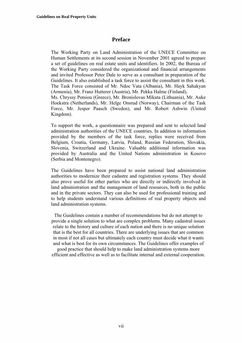
Preface The Working Party on Land Administration of the UNECE Committee on Human Settlements at its second session in November 2001 agreed to prepare a set of guidelines on real estate units and identifiers. In 2002, the Bureau of the Working Party considered the organizational and financial arrangements and invited Professor Peter Dale to serve as a consultant in preparation of the Guidelines. It also established a task force to assist the consultant in this work. The Task Force consisted of Mr. Ndoc Vata (Albania), Mr. Hayk Sahakyan (Armenia), Mr. Franz Hutterer (Austria), Mr. Pekka Halme (Finland), Ms. Chryssy Potsiou (Greece), Mr. Bronislovas Mikuta (Lithuania), Mr. Auke Hoekstra (Netherlands), Mr. Helge Onsrud (Norway), Chairman of the Task Force, Mr. Jesper Paasch (Sweden), and Mr. Robert Ashwin (United Kingdom). To support the work, a questionnaire was prepared and sent to selected land administration authorities of the UNECE countries. In addition to information provided by the members of the task force, replies were received from Belgium, Croatia, Germany, Latvia, Poland, Russian Federation, Slovakia, Slovenia, Switzerland and Ukraine. Valuable additional information was provided by Australia and the United Nations administration in Kosovo (Serbia and Montenegro). The Guidelines have been prepared to assist national land administration authorities to modernize their cadastre and registration systems. They should also prove useful for other parties who are directly or indirectly involved in land administration and the management of land resources, both in the public and in the private sectors. They can also be used for professional training and to help students understand various definitions of real property objects and land administration systems.
The Guidelines contain a number of recommendations but do not attempt to provide a single solution to what are complex problems. Many cadastral issues relate to the history and culture of each nation and there is no unique solution that is the best for all countries. There are underlying issues that are common in most if not all cases but ultimately each country must decide what it wants and what is best for its own circumstances. The Guidelines offer examples of
good practice that should help to make land administration systems more efficient and effective as well as to facilitate internal and external cooperation.
vii

Guidelines on Real Property Units
viii

Guidelines on Real Property Units
Executive Summary
These Guidelines have been prepared to assist countries re-engineering their land book and cadastral systems and to help those who are seeking harmonization across the European Union so that data relating to real property can be shared, thus expanding the global land and property market. The efficient and effective management of private land rights and the provision of open access to accurate information about land are important elements of good governance. They create the basis for sound decision-making by citizens, businesses and government, and help to smooth the operation of the land market, which in turn underpins the wider economy. In considering the need for effective systems of real property units and land parcel identification it is necessary to consider first the wider significance of land as the basis of social stability and economic well-being. In part one of the Guidelines (chapters I to IV) there is a review of the nature of land and land administration and the management of real property information. This sets the scene for part two (chapters V to VII), in which the development of an effective system of real property and parcel identification is discussed. Part three (chapter VIII) draws conclusions and makes suggestions for what constitutes good practice. The Guidelines recognize that land may be viewed from different perspectives. The ordinary citizen and the physical planner may think of it as the actual space in which people live and work; the lawyer may think of it as a set of real property rights, while the economist and accountant may see it as an economic commodity. Others may see it as part of nationhood and their cultural heritage. From whatever perspective it is a resource that must be carefully managed for the benefit of future generations. The information infrastructure that supports this management is known as land administration, which in particular focuses on the ownership, value and use of land. Secure title and an efficient land market can stimulate investment and economic growth. Insecure title and an inequitable land market lead to poverty amongst the less advantaged. Real property, which includes land and the buildings that are attached to the surface of the earth, is made up of a variety of rights that relate to different volumes of space. The way that these rights are held is known as the tenure, the types of which, as with the rights themselves, vary among countries. There is no single model that fits all countries, just as there are no two countries that have identical land administration systems. The Guidelines explore some of these differences and the varied terminology that is used. This is especially apparent in the definition of the basic spatial units that are recorded in land book and cadastral systems. The most important component of such systems is the land parcel, here defined as a single closed
ix

Guidelines on Real Property Units
area or polygon that is determined geographically by its boundaries, contains land under homogeneous property rights and is held in one ownership.
The parcel is registered in a cadastre or real property registration system and is usually shown as an area although in fact it represents a volume of space. It may consist of several plots, each plot being a closed polygon that is normally definable by the way in which the land is or may be used. One or more parcels (adjoining or non-adjacent) in the same ownership make up what in these Guidelines is referred to as a basic property unit (BPU) – such as a house with a garage that is at a separate location. Information about ownership is the same for the entire BPU; thus if one purchases the BPU one acquires all rights and obligations such as undischarged mortgages or sub-leases associated with it. The BPU is normally the basic real property object in the land book or land register, although some registration systems record only the land parcel. In some countries the property of a landowner may be made up of several BPUs, for example where adjacent land has been purchased but not amalgamated into a single BPU in the registers. Such a unit of property is referred to here as the ‘proprietary unit’. The term ‘portfolio of ownership’ is used to refer to one or more proprietary units in the possession of one legal entity. The distinction between a portfolio and a proprietary unit or BPU arises in cases such as that of a farm that is made up of a series of scattered fields that constitute one proprietary unit or BPU, while an investment portfolio may be made up of several separate units in different administrative areas across the country. In many cases all these terms refer to the same extent of land, as in a private detached house with a garden in which the plot, the parcel, the BPU and the proprietary unit may be all the same object. Although the terminology is different in every country, in these Guidelines the following hierarchy of ownership is recognized, from the top down:
1. A portfolio of ownership. 2. The portfolio may consist of several proprietary units (commonly
referred to as several properties). 3. The proprietary unit may consist of several BPUs although often it is
the same as a BPU. 4. The BPU may consist of several parcels. 5. Each parcel may consist of several plots. 6. A plot is something that can be plotted on a map and is often
identifiable by the way in which the land is used or managed. As a general rule, if an identifiable volume of space is or has been subject to a legal transaction or has been recorded as an independent entity in the registers then it constitutes at least one parcel. In practice in many countries in Europe a BPU consists of only one parcel. Real property registration systems record BPUs and parcels (if they are not the same object) but only some countries
x

Guidelines on Real Property Units
identify the portfolio of ownership as a separate entity. Many countries do not register plots as separate parts of parcels. Each parcel needs a unique identifier so that data concerning the parcel can be given an exclusive reference. The form of this reference varies from country to country. Within the land book and cadastral systems the identifiers used at present generally reflect historical practice rather than contemporary need. Since almost all land registers and cadastres have been or are being computerized, two types of identifier can be distinguished – one that is needed internally by the computer and the other that is convenient for human beings. These Guidelines discuss the options for the latter and ignore the demands of the internal workings of database management systems. Postal addresses are used for a variety of purposes in many different applications of which land administration is only one. From a land administration perspective it is however desirable that the address can be used to link data from a variety of sources. In particular the references used in the land books, in the cadastre, other government agencies and the municipalities / local government authorities should be compatible. No one specific solution is recommended since conditions vary between countries. Just as there is no unique cadastral solution that fits all countries, so there is no unique address system. The Guidelines provide a framework within which appropriate identifiers can be developed. As harmonization across Europe gathers pace a specifically European solution may emerge. This is not yet the case.
xi
Guidelines on Real Property Units
Country abbreviations The following abbreviations are used for the selected UNECE member countries:
AT = Austria NL= Netherlands BE = Belgium NO = Norway CH = Switzerland PO = Poland DE = Germany RU = Russian Federation FI = Finland SE = Sweden GR = Greece SK = Slovakia HR = Croatia SI = Slovenia LT = Lithuania UK = United Kingdom LV = Latvia UA = Ukraine
xii

Guidelines on Real Property Units
Part One
SETTING THE SCENE The following four chapters provide a review of the legal and conceptual framework within which real property rights are administered. In setting the scene, the nature of land and land administration is examined. No two countries have exactly the same approach although there are many common elements. Part One identifies the context within which appropriate real property units and identifiers need to operate.
I. THE BACKGROUND TO LAND ADMINISTRATION
A. Land and its social and economic importance Land can be viewed from a variety of perspectives, depending on the context within which it is being discussed.
Land
Physical space Economic resources Food and Land shelter markets Cultural heritage Rights and obligations Figure I. Perspectives on land
1. Land is a physical reality Land provides the physical space in which we all live, work and play, and from which we obtain our material needs. If it is taken to include areas that are covered by water, then all living creatures are dependent upon the land for food, shelter and social interaction. Land is the foundation of all human activity and its proper management is a key to the creation and sustenance of civilized societies (Dale and McLaughlin, 1999).
2. Land is of economic valueLand may also be viewed from an economic perspective. It is the basis for economic production and development and the creation of wealth. From it we obtain food and water, materials to build our homes, our shops and factories, and products such as oil, coal and gas that supply us with energy. It is a commodity to which a value can be assigned and which can be traded through land markets. It is also a commodity that can be taxed to produce revenues that support good governance.
1

Guidelines on Real Property Units
3. Land is a legal entityTo ensure the optimum use of space and to enable the land market to operate efficiently and effectively there must be a framework of land and property laws. From a legal perspective land may be viewed as an abstract set of property rights that provide security of tenure and govern the way in which the land may be used and how dealings in land may be transacted. These rights may extend ‘from the centre of the Earth to the infinite in the sky’, that is, they affect what is below and above the surface of the Earth so that the minerals beneath the surface and the air above may be regarded as part of the land. The law defines the relationship between these rights and the people who own them and thus underpins the processes that lead to the creation of wealth.
4. Land is a cultural entityUnlike personal property and the ownership of movable objects, land is immovable and indestructible. It therefore has a cultural dimension that lies at the heart of any nation. Throughout history nations have resorted to war over the possession of land, while at the local level citizens may fight to defend their own personal territories with many disputes over boundaries being resolved at a cost that far exceeds the economic value of what is involved. People often have an emotional relationship with the land that they claim to own and the locality in which they live, which is why the proper administration of the land is a necessity for stable societies and social justice.
B. Cadastres and land registration systems There are various ways in which details about the land may be recorded, reflecting the diverse ways in which land can be viewed. Broadly speaking there have been two approaches, one focusing on its legal aspects and the other on its fiscal or resource potential. The former, called land registration or the land book system, concentrates on the abstract rights associated with the land. The latter is the cadastre and often contains more evidence about the physical size and shape of areas, and data on land values or land use. Dual and integrated systems exist, depending on the history of the country concerned. Land registration is the process of recording rights in land either in the form of a register of deeds and other documents associated with the ownership of the land rights or else in the form of a register of titles to land. The titles registers are supported by maps such as topographic maps that do not necessarily show legal boundaries or cadastral maps, the origins of which often lie in real property taxation rather than land registration. Land registration is a component of good governance. If wealth is to be generated from land then according to the UNECE report on the Social and Economic Benefits of Good Land Administration (HBP/1998/8, para.5): “For nations to unlock that wealth requires effective systems of land registration. Good land registration promotes an active land market and productive land use. It makes possible the security of tenure and the
2

Guidelines on Real Property Units
development of a mortgage market on which a functioning economy depends.” Land registration provides security of tenure for those whose land is registered. In much of Europe the records of ownership have been maintained in land books, for example the German Grundbuch (Hawerk, 1995). Such records identify the piece of land affected, the names of the owners and the particular property rights that are associated with it. In addition to the land books many countries have a cadastre, which is also a register of the land. The cadastre may record ownership, but more usually it has focused on the geometric characteristics of the properties together with the value of the real property and the use to which the land is put; in the latter case, for instance in Switzerland, it may also make reference to the rules and regulations for the use of land. Every country has a different cadastral system although increasingly many are now serving a multi-purpose role.
Cadastre Land books Maps
and other property
descriptions
Note: No two countries operate identical cadastral systems since a cadastre is part of a country’s social infrastructure. Like nations, each system has evolved with different characteristics.
Figure II. Cadastre / land registration overlap In general, cadastres can be described as juridical (focusing on ownership), fiscal (focusing on land and property values for taxation), land use (recording the different ways in which the land is used) and multi-purpose (serving a variety of needs) (Dale, 1976; Larson, 1991). In some countries the term ‘juridical cadastre’ is taken to refer to the land book, although strictly speaking a cadastre should cover the whole of a country while many land book systems contain details of only those parcels that have been subject to a land transaction. Some cadastres contain relatively few items of information, while others are more complex (for example, see annex II and the contents of the register in Lithuania). In some cases countries have operated several cadastres, each with a different objective and this has resulted in the same information being registered at least twice. A key element in many land record systems is the cadastral map or plan. The term ‘plan’ is often used since historically most graphical representations of areas of ownership treat the land as two-dimensional or flat. Cadastral plans serve one of two purposes – to locate areas of land and to provide information about each area. They may provide details about a single parcel of land in support of a land book entry (in which case they may be called filed plans, title plans, survey plans or even cadastral diagrams); or they may show all the parcels within a given area and thus act as an index to help identify each one of them relative to the others (hence they may be called index or cadastral maps or plans). In some cases the data on index maps are less geometrically
3
Guidelines on Real Property Units
precise than on cadastral plans. In both cases they provide important information on the location, size and shape of the land that is registered.
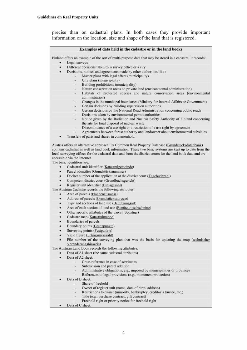
Examples of data held in the cadastre or in the land books
Finland offers an example of the sort of multi-purpose data that may be stored in a cadastre. It records:
• Legal surveys • Different decisions taken by a survey office or a city • Decisions, notices and agreements made by other authorities like :
- Master plans with legal effect (municipality) - City plans (municipality) - Building prohibitions (municipality) - Nature conservation areas on private land (environmental administration) - Habitats of protected species and nature conservation areas (environmental
administration) - Changes in the municipal boundaries (Ministry for Internal Affairs or Government) - Certain decisions by building supervision authorities - Certain decisions by the National Road Administration concerning public roads - Decisions taken by environmental permit authorities - Notice given by the Radiation and Nuclear Safety Authority of Finland concerning
the site for final disposal of nuclear waste - Discontinuance of a use right or a restriction of a use right by agreement - Agreements between forest authority and landowner about environmental subsidies
• Transfers of parts and shares in commonhold. Austria offers an alternative approach. Its Common Real Property Database (Grundstücksdatenbank) contains cadastral as well as land book information. These two basic systems are kept up to date from the local surveying offices for the cadastral data and from the district courts for the land book data and are accessible via the Internet. The basic identifiers are:
• Cadastral unit identifier (Katastralgemeinde) • Parcel identifier (Grundstücksnummer) • Docket number of the application at the district court (Tagebuchzahl) • Competent district court (Grundbuchsgericht) • Register unit identifier (Einlagezahl)
The Austrian Cadastre records the following attributes: • Area of parcels (Flächenausmass) • Address of parcels (Grundstücksadresse) • Type and sections of land use (Benützungsart) • Area of each section of land use (Benützungsabschnitte) • Other specific attributes of the parcel (Sonstige) • Cadastre map (Katastralmappe) • Boundaries of parcels • Boundary points (Grenzpunkte) • Surveying points (Festpunkte) • Yield figure (Ertragsmesszahl) • File number of the surveying plan that was the basis for updating the map (technischer
Veränderungshinweis) The Austrian Land Book records the following attributes:
• Data of A1 sheet (the same cadastral attributes) • Data of A2 sheet:
- Cross reference in case of servitudes - Subdivision and parcel addition - Administrative obligations, e.g., imposed by municipalities or provinces - References to legal provisions (e.g., monument protection)
• Data of B sheet: - Share of freehold - Owner of register unit (name, date of birth, address) - Restrictions to owner (minority, bankruptcy, creditor’s trustee, etc.) - Title (e.g., purchase contract, gift contract) - Freehold right or priority notice for freehold right
• Data of C sheet:
4

Guidelines on Real Property Units
- Encumbrances (including mortgages) - Title (e.g., mortgage bond and its date) - Beneficiary of title (e.g., mortgagee) - Amount of mortgage
These documents form the basis of a single registration. In the words of the UNECE Guidelines on Land Administration “The modern cadastre is not primarily concerned with generalized data but rather with detailed information at the individual land parcel level. As such it should service the needs both of the individual and of the community at large. Benefits arise through its application to: asset management; conveyancing; credit security; demographic analysis; development control; emergency planning and management; environmental impact assessment; housing transactions and land market analysis; land and property ownership; land and property taxation; land reform; monitoring statistical data; physical planning; property portfolio management; public communication; site location; site management and protection. Although land records are expensive to compile and to keep up to date, a good land administration system should produce benefits, many of which cannot in practice be quantified in cash terms”.
C. The scope of land administration The term ‘land administration’ refers to the management of information about the ownership, value and use of land and its associated resources. The function of a land administration system is to record, maintain and make available information that can create security of tenure and support the land market. Ownership is essentially a legal process that depends on ‘title’, that, is the evidence that proves who has the right to property. The way in which rights over land are held is referred to as the system of land tenure, the most common forms of which are called freehold and leasehold. Freehold provides the owner with the maximum rights permissible within the tenure system; it is subject to a variety of restrictions, for example those imposed by physical planning regulations, and to the right of the State to acquire the land in the overall national interest (sometimes called the right of eminent domain). Leasehold arises where there is a contractual arrangement under which a landlord (the lessor) grants the right of exclusive occupation of the land to a tenant (the lessee) for an agreed amount of money for an agreed period of time. Leasehold implies that there is a superior landowner (ultimately the freeholder), though when leases run for 999 years this may seem academic. Although such long leases are now unusual, periods of up to 99 years are still common. All land has a value, although what it is worth depends on what is meant by ‘value’ (Dale and McLaughlin, 1999; Eckert, 1990; IVSC, 2001). From a financial perspective, this may relate to the price that would be paid for the land in an open market sale, the revenue that could be obtained from renting
5

Guidelines on Real Property Units
out the use of the land (known as the rental value), the construction costs for a building, or the value assessed for taxation purposes based on parameters such as its area and soil type that may not be directly connected with market prices. Land values are discussed in some detail in the report on the Workshop on Mass Valuation Systems of Land (Real Estate) for Taxation Purposes (Federal Land Cadastre Service of the Russian Federation, 2002). The term ‘land use’ relates to the manner in which the land is exploited, including the nature of the vegetation upon its surface. National governments place restrictions on the way in which land can be used through regulations the nature of which is dependent on whether the land is rural or urban. Town planning regulations, for example, define zones of activity (industrial, commercial, residential) and impose building codes that inhibit the choice of a landowner. Environmental legislation may restrict what can be done with agricultural or other forms of rural as well as urban land. What is permitted in the way of development severely affects the market price of land. Thus if land may only be used for agricultural purposes its market price will in general be much less than if permission is given to build upon it. Land of uncertain ownership or insecure tenure will be less valuable than land where the ownership rights can be guaranteed.
D. The land market Land markets exist in a number of forms. They may be formal and subject to the procedures laid down by the State, or informal and unstructured as is often the case in less developed economies. They operate in rural areas, where the main interest is usually in agricultural land or forestry, and in urban areas, where industrial, commercial and residential interests predominate. They may be based around the sale of freehold or long-term leasehold (the sales market) or on shorter-term leases (the rental market). They may involve the sale of specific rights in the land such as air rights or profit à prendre, in which the right to take produce or other benefit from the soil is sold to another person. Land markets may also take the form of mortgage markets. A mortgage involves the transfer of certain rights in a legal estate as security for a financial loan with the provision that those rights will cease when the loan is paid off by a certain date. The mortgage may be in the form of a written agreement or the deposit with the lender of the title deeds of the borrower’s land. Land sales markets influence the level of investment in industry and the efficiency of agricultural production since the land can be used to borrow money against the estimated market price that would be paid for the property. In urban areas rental markets create opportunities for people to migrate to where work is currently available, while for rural communities they allow agricultural land to be used more efficiently by farmers renting land that they cannot afford to buy but which they can use productively.
6

Guidelines on Real Property Units
Secure More title credit Higher & & product- Economic Higher efficient more ivity growth incomes market invest- ment Figure III. Wealth improvement through the land market
It has been argued for example by authors such as De Soto in his book on the Mystery of Capital (De Soto, 2000) that one reason why poverty is so rife around the world is that many people do not have access to an efficient land market and are unable to turn their assets from dead capital into real usable wealth. De Soto has estimated that these dead assets are potentially worth trillions - that is thousands of billions - of United States dollars. It should be possible for this capital to be released for other purposes if there is an efficient and open land market so that (Dale and Baldwin, 2000):
• There are secure dealings in land; • The cost of transactions is low; • There is access to credit; • There is transparency and easy access for all participants; • Minority rights are protected; and • Environmental sustainability is supported.
The market value of any real property depends in part on its location. The identification and accurate description of real property units and their relation to neighbouring properties is essential if land markets are to operate smoothly and openly for the benefit of all. Real property identifiers provide a link between the various components of a land market. A clear definition of what is to be transacted and where it is located is central to the land development process. Failure to identify the ownership and rights surrounding real property units has had disastrous consequences in many development programmes, especially those designed to help low-income communities.
7

Guidelines on Real Property Units
II. THE NATURE OF REAL PROPOERTY
A. Property and property rights Property may be defined as an object to which legal rights may be attached, especially rights of ownership. The object may be tangible, as in the case of physical pieces of land (in which case it is often referred to as real property) or an item such as a personal possession that has been bought in a shop, or intangible as in copyright that may relate to a piece of intellectual property. Property can be held by individuals or groups of individuals, legal persons (organizations such as companies or banks), or by the State (including municipalities). In Western society most tangible things are regarded as property and are associated with a set of property rights. Property law deals with relationships between and among persons with respect to things by providing rules on how these rights can be acquired, used or transferred. Rights are intangible even though they deal with tangible objects such as a piece of land. Thus an individual person may own the abstract right to sell a physical piece of land. This right will be passed to the purchaser on sale of the freehold. Although this process may be referred to as land transfer, it is the ownership right that is transferred, not the physical commodity as this is immovable. The rights over land can be divided into parts, some of which are in the possession of the main landowner but some of which, such as a right of way over the land, may belong to others. They have been described as a bundle of sticks, each stick identifying a particular right, and although there is a complete bundle for each piece of land, that whole bundle is not normally in the possession of one individual. Thus, for example, there will most likely be public regulation of land use or put another way a set of sticks that is in the possession of the local government authority or municipality that determine what the landowner can do with the land. The landowner may not, for example, have the right (the stick) to erect a new building on the land. The division of land into separate identifiable land rights can be further complicated through sharing of the ownership of the various rights. Thus on the death of the landowner, the property may be sold and the money divided between the heirs; or the land itself may be broken up into smaller areas, one for each heir; or the land rights may be distributed between the heirs either in the form of shares or some rights to one heir and some to another. These divisions may be dictated by the will of the deceased or in accordance with rules such as those under Islamic Shariah. The consequence is fragmentation, that is, the land rights are broken into smaller parts in which there may be a multiplicity of owners each with a number of shares in the land, or a multiplicity of parcels that over time may result in one landowner having various plots scattered across the countryside.
8

Guidelines on Real Property Units
B. Ownership and possession of land The complexity of rights is compounded by the distinction between ownership and possession of real property. With personal property the distinction is usually clear – there is an identifiable owner who normally has possession of the object. The object may be stolen hence the thief has possession of it but not ownership. Land of course cannot be moved hence only the rights inherent in it can be transferred. It is more difficult to steal land than to steal moveable objects; stealing land is only possible through forceful occupation or by fraudulently changing the record of ownership. The ownership of land does not necessarily imply being in possession in the sense of occupation. The owner may possess the absolute rights but have granted occupancy to others, for example through a leasehold agreement. In some jurisdictions the peaceful, exclusive and continuous occupation of land for a specified period without any acknowledgement of a superior landowner can lead to the acquisition of absolute property rights. This process is known as adverse possession and allows land of unknown ownership to be brought back into the formal ownership system after a period of time such as 15 or even 30 years. In Greece, for example, the period is 20 years for private land but it does not apply to State land. If the occupation of the land is not peaceful or if even an amount as little as one peppercorn is paid in rent to the true owner then the absolute rights cannot be acquired by this means.
C. Rights in real property Rights in land are sometimes referred to as interests in land, because when a ‘transfer of land’ takes place what actually happens is that interests in the land are passed from one person to another. The ownership of land means the ownership of certain interests in the land. These interests in land may include the right to buy (in some countries foreigners cannot acquire this right, while in others there are special restrictions in border areas) and rights to sell or lease it to someone else. They may include easements (such as rights of way and other third-party interests), profits (such as the right to take minerals, cut trees or take fruit such as olives), and restrictions such as mortgages in which either the rights are transferred temporarily in exchange for the loan of money or else the right to sell is transferred in case a debt is not repaid in time. They also include rights of use, many of which are controlled by physical planning regulations, such as rights to build on the land or perform certain functions such as sell goods. Other restrictions come, as in Greece, from the Archaeological Service, which protects ancient sites and antiquities, impacting adversely on the land market (UNECE, 2002). In such cases the absence of a right is a restriction, which in effect is a negative right.
9

Guidelines on Real Property Units
In some legal systems there is an underlying assumption that unless a right is provided by the law it does not exist; in others a right exists unless it has been taken away by laws and regulations. Rights can also be removed by the landowner in the form of restrictive covenants; for instance ‘A’ sells the land in freehold to ‘B’ subject to the restriction that ‘B’ may not use the property for a particular purpose such as erecting a building above a certain height in order to protect A’s view of the landscape. In countries such as the Netherlands a distinction is made between limited real rights (such as usufruct, long-term leases, easements, etc.) and personal rights (rent of a house, 12-year land lease, any kind of agreement between an owner and a user about the use of the land, etc.). Limited real rights (except some special rights such as the lifelong right to live in a certain part of a building) can be sold separately from the main ownership right. After the death of the owner the limited right passes to the person’s heirs and ‘runs with the land’, that is, it will continue even when the main ownership right is sold. In the Netherlands, personal rights on land normally end when the land is sold, unless there is a special legal agreement or a law that provides for their continuation. They are not registered in the Cadastre and cannot be sold nor can they be passed on to heirs without the cooperation of the freeholder. In most countries the full set of property rights is not documented. Furthermore, the interests in agricultural land are very different from those in cities and towns. From a land administration perspective, what is recorded in the land books and cadastral registers is normally a small subset of the rights that exist on the ground. There are many overriding interests that have legal force even though they are not recorded in the land registers, such as traditional rights of way or rights to light. In addition to the general category of ‘freehold’ the registers often record:
• Caveats or cautions (the right to be notified of intended dealings) • Charges on the land (third-party rights) • Construction rights (such as the right to erect a new building or change an old
one) • Easements/servitudes (such as rights of way) • Long-term leases (for instance for more than 12 years) • Mortgages (the right of a lender to acquire the property if a debt is not repaid) • Mining rights (the right to extract and profit from oil or minerals) • Pre-emption rights (the priority right to purchase the land) • Restrictions on use (for instance restrictive covenants) • Seizures (where land is taken into legal possession) • Shares in condominiums (the rights to all or parts of buildings) • Specific rights (that are not otherwise identified and apply only to the property) • Trusts (where land is held by one legal person for the benefit of another) • Usufruct (rights to use the land)
10

Guidelines on Real Property Units
When asked what rights in addition to freehold appeared on the registers, 18 countries replied: Right
A T
B E
C H
D E
F I
G R
H R
L T
L V
N L
N O
P O
R U
S E
S K
S I
U K
U A
Cautions and caveats Charges on the land Construction rights Easements / servitudes Long-term leases Mining rights Mortgage / hypothec Pre-emption rights Restrictions on use Rights to profits Seizures Shares in condominiums Usufruct etc.
√ √ √ √ √ √ √ √ √ √ √ √ √
√ √ √ √ √ √ √ √
√ √ √ √ √ √ √ √ √ √ √ √ √
√ √ √ √ √ √ √ √ √ √
√ √ √ √ √ √ √ √ √ √
√ √ √ √ √ √ √ √ √ √
√ √ √ √ √ √ √ √ √
√ √ √ √ √ √ √ √ √ √
√ √ √ √ √ √
√ √ √ √ √ √ √ √ √ √ √ √
√ √ √ √ √ √ √ √ √ √ √
√ √ √ √ √ √ √ √ √ √ √
√ √ √ √ √ √ √
√ √ √ √ √ √ √ √ √ √
√ √ √ √ √ √ √ √ √
√ √ √ √ √ √
√ √ √ √ √ √ √ √ √
√ √ √ √ √ √ √ √
D. Tenures The manner in which land rights are held is known as the tenure. There are many forms of tenure, the most common being absolute or freehold, and leasehold. By ‘absolute’ it is meant that there is no other person who has a better right to the land, not that the landowner has absolute freedom to do whatever he or she likes with it. Rights are limited partly for environmental reasons and partly in the interest of good neighbourliness. They are also subject to national interests (UNECE, 1996). Rights may be held by individuals or groups of individuals (FIG, 1995). The tenure system for apartment blocks or condominiums must take into account the ownership not only of the individual apartments but also of the common areas. In Greece and Norway, for example, the ownership rights in the common areas are divided amongst the owners of the condominiums in proportion to the area/size of their apartment. In a number of countries in transition these common areas were until recently the responsibility of the municipality, but with increased privatization new forms of tenure have had to be created. Likewise, until formal land markets became active, there was no need to address the manner in which land was mortgaged and how the rights of both the lender and borrower could be protected. Forms of tenure are dynamic, with new arrangements being created to deal with changed circumstances and some old rights being abolished through land tenure reform. New rights were, for example, created in the case of ‘time-sharing’ in which an owner buys an apartment to occupy for certain specified weeks in each year. This form of tenure has caused some social problems, where people have committed themselves to a contract that has turned out to be disadvantageous. As a result, the European Union felt obliged to issue guidelines for consumer protection under EU Directive 94/47/EC.
11
Guidelines on Real Property Units
III. THE THIRD DIMENSION
Real property is most often thought of as pieces of land on the surface of the Earth, including or excluding buildings and other things permanently attached to the surface. However, in reality these pieces or ‘parcels’ extend upwards into the air and downwards into the ground. Most European countries define the parcel as extending from the centre of the Earth to the ‘sky’, although some countries limit private ownership to certain levels. Hence parcel boundaries are in reality not lines on the ground but vertical planes. The boundary lines that are marked on the ground are where these vertical planes intersect the surface of the Earth. The third dimension facilitates subdivision into strata, creating separate ‘parcels’ above or under the original surface area. The most typical parcels located above the surface are apartments or buildings registered as separate real property. Increasingly constructions like tunnels and platforms (such as the foundations for buildings, etc.) below or above the surface are also regarded as subdivisions and registered as separate real property. In some jurisdictions, networks such as telecommunication lines may also be registered either within the cadastre (as has been proposed in the Netherlands) or in a separate register as for high-voltage power lines in Norway. The registration of networks will not, however, be considered here.
A. Land versus buildings Depending on the jurisdiction, the definition of land may or may not include all things attached to it such as buildings on the surface, or vegetation growing on it, or minerals below the ground. Under English law, for example, “land” includes land of any tenure, and mines and minerals, whether or not held apart from the surface, buildings or parts of buildings (whether the division is horizontal, vertical or made in any other way) and other interests in real property that can be inherited. It also includes easements, rights and other benefits that exist in, over, under or are derived from land. It thus encompasses physical things attached to the land, such as plants and trees growing in the soil, as well as intangible rights. In some jurisdictions a clear distinction is made between land and buildings. In addition, some countries maintain separate registers of buildings, for instance for the purpose of taxation, even though within the land registration system the land is taken to include the buildings on it. From a valuation perspective and from the point of view of maintenance, buildings are very different from the land on which they stand and have a different economic value and maintenance cost. In city centres it is common to find underground transport systems (such as metros and road underpasses), utilities such as sewers and waterways, and underground shopping malls. Whereas some of the rights to these are protected through easements, others may require registration as below-ground or above-
12

Guidelines on Real Property Units
ground property units. Most cadastres, however, in effect regard the Earth as flat and record land in two dimensions.
Figure IV. Rights exist below, on or above the land
When asked whether buildings are defined as part of the land on which they stand, 18 countries responded as follows (Y= Yes, N = No): AT BE CH DE FI GR HR LT LV NL NO PO RU SE SK SI UK UAY N Y Y Y Y Y Y Y Y Y Y N Y N Y Y N
B. Rights in condominiums Condominium ownership comes in a variety of forms from multi-apartment buildings used exclusively for residential purposes to those that contain both residential units and space used for commercial purposes. They may extend vertically as in tower blocks or horizontally as in terraced houses. Essentially such buildings have two components – privately owned units and jointly owned parts. The right in freehold to a separate apartment in a tower block breaches the idea that land, as real property, extends from the centre of the Earth to the infinite of the sky. The concept that the land is a single unitary object may work in legal theory but in practice it needs to be modified, especially in the case of ownership of individual apartments in a block of flats. Here different laws and concepts need to be applied. Some countries avoid the question of freehold by focusing on rights to use the building and rights of occupancy. This will only work so long as some legal body is responsible for the infrastructure that supports the whole apartment block. Jointly owned parts of a condominium are those parts that cannot
13

Guidelines on Real Property Units
clearly be regarded as the responsibility of one unit owner, for example service areas and equipment such as lifts that are used by the whole condominium community, sections of the water and electricity and heating supply, the roof and the foundations of the building, etc. The UNECE Guidelines on Condominium Ownership advocate the appointment of an administrator who is legally responsible for managing the parts that are in joint ownership. (UNECE, 2003).
C. Rights to minerals and hydrocarbons Rights to trees and other vegetation on the surface of the land normally belong to the landowner, although, for instance, in Greece there are old records showing separate rights associated with olive trees; new rights of this sort cannot, however, be created. Likewise, if the use of the land has been granted to a tenant in exchange for rent then the crops grown will belong to the tenant, unless the rent takes the form of a share of the crops. Otherwise, what is attached to the soil belongs to the landowner. Certain items below the surface of the Earth may belong to the State. In the United States, if a landowner finds oil under the land then he or she will benefit. Throughout much of Europe, however, specified minerals and hydrocarbons such as oil and gas belong to the nation as a whole. If, for example, the State allows a firm to extract coal from beneath the land then a payment for rent of the space that is used may be made to the landowner although he or she may have no rights to the profit from extracting the coal. In Greece, for example, minerals and hydrocarbons belong to the State, while marble or other construction materials that are extracted from the land belong to the owners.
D. Rights to water Given the definition of land as extending from the centre of the Earth to the sky, the ownership of land covered by fresh water is no different from dry land. Nevertheless, some jurisdictions limit the extension of private ownership to the land covered by fresh water. There is a need to distinguish between the right to take or otherwise use fresh water and the physical extension of ownership into land under rivers and lakes. If a river runs through an individual’s land then the owner of the bed of a river has certain rights and responsibilities, one of which is normally to ensure that people further downstream can also enjoy access to clean water. The bed of some rivers may not, however, belong to the owners on either side and, conversely, someone in a boat travelling down the river may not have rights of access to the bank. Whether a stream is a right of way is generally a matter of history; technically, access to it is usually no different from land that is not covered by water, except in the case of tidal rivers and estuaries. Rights of access to water can be complex, especially in countries where water is in short supply and where there are restrictions on the use of water for irrigation. It is also normal to find special environmental protection legislation
14

Guidelines on Real Property Units
that seeks to maintain water quality. Often there is a right to take water from a stream for domestic purposes or, for example, to water cattle and livestock, but if the water is required for commercial purposes then it must be returned in the same quantity and quality as it was extracted. The right to profit from the water (such as through fishing in a stream) may lie with the landowner, who may in the past have granted these rights to others; thus new purchasers may not necessarily have the right to fish on their own land. In Greece, for instance, all these rights to profit from the water belong to the State and to all citizens; that is why where there is commercial profit a licence is required, for example by fishermen. In most countries a separate set of rights deals with water that is tidal (and hence salt water). Usually, a landowner who owns land down to the high- water mark (that is, as far as the highest tides reach) owns no further. The ownership of land between the high- and low-water mark is sometimes contentious, especially where hotels by the seaside seek to exploit the area for the exclusive benefit of their guests. Land beyond low water, which is always covered by the sea, normally belongs to the State. In Croatia a belt of the dry land that is a minimum of six metres wide along the entire coast including islands is defined as public land and is registered as parcels in public ownership. In Norway, on the other hand, private ownership traditionally extends to two metres depth or to the topographic break line that can be regarded as the natural limitation of the dry land into the sea.
When asked whether properties can consist of water areas only, without dry land, 18 countries replied (Y = Yes; N = No): AT BE CH DE FI GR HR LT LV NL NO PO RU SE SK SI UK UAY Y Y Y Y N N Y Y Y Y Y Y Y N Y Y N
15

Guidelines on Real Property Units
IV. LAND USE AND LAND USE RIGHTS
A. The definitions of land use The term ‘land use’ has a variety of meanings from the nature of the vegetation that grows upon the land to the human activities that relate to the land and are carried out upon its surface. At its simplest level, it is a classification of the land, for example, into:
• Settlements and associated non-agricultural land • Horticulture • Trees and other perennial crops • Cropland • Improved permanent pasture • Unimproved grazing land • Woodlands • Swamps and marshes • Unproductive land
Each category can then be subdivided, with for example cropland classified as wheat, barley, oats, cabbages, carrots, etc. Such a categorization was used in a world land use survey and views the land very much from a rural perspective. From an urban perspective, the main categories normally include:
• Residential • Commercial • Industrial • Services such as schools and hospitals • Transport including roads, railways and waterways • Recreational such as parks and open spaces
Each category can have subcategories, for example ‘commercial’ could be divided into shops and offices, with each of these subdivided in turn. Each broad category represents a zone in which a certain activity may be permitted. Several activities may take place within a zone, for example where a transport net services an industrial area, or where buildings have dual functions (a shop on the ground floor and residential apartments on the floors above that). For the purposes of gathering statistical data the Statistics Office of the European Union (EUROSTAT) categorizes land as:
1.1. Administrative units 1.2. Settlements / morphological agglomerations 1.3. Marine water boundaries 2.1. Coastline 2.2. Water pattern / hydrological network 3.1. Road network 3.2. Railway network 3.3. Airports 3.4. Ports / harbours (coastal and inland) 3.5. Industrial plants 4.1. Orography (altitudes) 4.2. Bathymetry (sea depths)
A similar approach to that adopted by EUROSTAT was used in the European Commission’s CORINE Project, which mapped land cover throughout the
16

Guidelines on Real Property Units
European Union. It was based on a hierarchical approach with mapping at three main levels:
Level 1 Level 2 Level 3 1. Artificial surfaces 1.1. Urban fabric 1.1.1. Continuous urban fabric
1.1.2. Discontinuous urban fabric 1.2. Industrial, 1.2.1. Industrial or commercial units commercial 1.2.2. Road and rail networks and transport and associated land
1.2.3. Port areas 1.2.4. Airports
1.3. Mine, dump and 1.3.1. Mineral extraction sites construction 1.3.2. Dump sites
sites 1.3.3. Construction sites 1.4. Artificial 1.4.1. Green urban areas non-agricultural 1.4.2. Sport and leisure facilities vegetated areas
2. Agricultural areas 2.1. Arable land 2.1.1. Non-irrigated arable land 2.1.2. Permanently irrigated land
2.1.3. Rice fields 2.2. Permanent crops 2.2.1. Vineyards
2.2.2. Fruit trees and berry plantations 2.2.3. Olive groves
2.3. Pastures 2.3.1. Pastures 2.4. Heterogeneous 2.4.1. Annual crops associated agricultural areas with permanent crops
2.4.2. Complex cultivation patterns 2.4.3. Land principally occupied by
agriculture, with significant areas of natural vegetation
2.4.4. Agro-forestry areas 3. Forests and 3.1. Forests 3.1.1. Broadleaved forest semi-natural 3.1.2. Coniferous forest
areas 3.1.3. Mixed forest 3.2. Shrub and/or 3.2.1. Natural grassland herbaceous 3.2.2. Moors and heath land vegetation 3.2.3. Sclerophyllous vegetation
3.2.4. Transitional woodland shrub 3.3. Open spaces 3.3.1. Beaches, dunes and sand plains with little or 3.3.2. Bare rock no vegetation 3.3.3. Sparsely vegetated areas
3.3.4. Burnt areas 3.3.5. Glaciers and perpetual snow
4. Wetlands 4.1. Inland wetlands 4.1.1. Inland marshes 4.1.2. Peat bogs
4.2. Coastal wetlands 4.2.1. Salt marshes 4.2.2. Salines
4.2.3. Inter-tidal flats 5. Water bodies 5.1. Inland waters 5.1.1 Watercourses
5.1.2 Water bodies 5.2. Marine waters 5.2.1 Coastal lagoons
5.2.2 Estuaries 5.2.3 Sea and ocean
CORINE classification for land cover
17

Guidelines on Real Property Units
B. Land use controls and physical planning Physical planning is a process that defines and seeks to control the use of land in order to meet certain social objectives. It is the allocation of resources, including rights to use the land, in a way that will serve local, regional or national communities. At one level, it is a set of laws and regulations that determine the permitted density, height and volume of buildings and regulate the size and type of land parcel subdivision. At another level, it is a process that tries to protect the long-term interests of the environment and, hence, its sustainability. Physical planning has three main elements:
• Strategic or long-range planning, in which future patterns of land use, development, transport links, services, etc. covering a wide geographic area are proposed;
• Local or project planning, in which detailed site-specific plans are developed; and
• Development control, in which regulatory mechanisms are applied to specific changes of land use, building and construction in development projects.
The detailed practice of physical planning varies among countries, as does a local authority’s ability to enforce the regulations. There is also a significant difference between the way in which rural areas and urban areas are controlled. In general, however, planning at the local level is the responsibility of the local authority or municipality, operating within national guidelines. Land-use control may also be regarded as the process of enforcing real property rights. Each land-related activity is subject to property rights. What can be done with the land, and hence its economic potential, is partly determined by the details in the title to the real property, partly by the rights that are controlled by the local authority or municipality, and in some jurisdictions partly by the rights that are imposed by local tradition or under customary law. The separate areas of real property that are identified by homogeneous property rights and unique ownership, as recorded for instance in the land books, are known as land parcels. In Greece, by law, each land parcel is considered to have unique land use so that, if within one land parcel there are several types of use, only the main “land use” of the parcel is registered. From a land resource management perspective, the definition and identification of land parcels are of great importance even though the parcel is not the only unit that is used in the management of the land. This is because the boundaries of ownership of real property do not necessarily coincide with the boundaries that are followed by physical planning controls.
18

Guidelines on Real Property Units
Similarly, the extent of use of the land for crop growing may not be the same as that of ownership. This can, for example, result in difficulties in the European Union when data on the area of fields as shown on the cadastral plan are used to calculate levels of agricultural subsidies, as discussed below. The ownership and use of land are interconnected but the physical space that they relate to is not necessarily identical, since people can own land they do not use and use land that they do not own.
C. The integrated administration and control system Within the European Union, the referencing of one particular form of land use has been the focus of considerable investigation and research. Under its common agricultural policy (CAP), the European Union pays subsidies on food production through the integrated administration and control system (IACS). Some of these subsidies relate to the area of land that is used for growing certain crops. The EU has issued regulations that govern the way in which this is defined, notably in the original regulation 3508/92 as amended through regulation 1593/2000, which together with other rules, for instance on database reporting, lay down the procedures that are to be followed. The key unit for IACS is the agricultural parcel, although other units such as the cadastral parcel are permitted. Member States are required to ensure that agricultural parcels are reliably identified and, in particular, that areas under cultivation are accurately recorded. If too small an area is reported there will be a loss of income to the farmer, while if too large an area is claimed and if the area declared differs by more than two per cent from the true value the farmer will be fined. Regulation 1593/2000, article 4, states that :
“An identification system for agricultural parcels shall be established on the basis of maps or land registry documents or other cartographic references. Use shall be made of computerised geographical information system techniques including preferably aerial or spatial ortho-imagery, with an homogenous standard guaranteeing accuracy at least equivalent to cartography at a scale of 1:10,000.”
Article 6 states that :
“For each of the agricultural parcels declared, farmers shall indicate the area and its location, which information must enable the parcel to be identified in the identification system for agricultural parcels”.
IACS has resulted in the development of the integrated farm register and a land parcel identification system, but this has not necessarily been coordinated with other identification systems that operate within each country. Indeed, because of the inevitable time delays in establishing a cadastral system across the whole of a country, IACS has been developed independently, thus creating a parcel identification system that may be different from that being established
19

Guidelines on Real Property Units
under the cadastre. This also leads to the duplication of effort, the creation of similar data sets that may conflict, and additional costs (Potsiou et al, 2002).
20

Guidelines on Real Property Units
Part Two
REAL PROPERTY UNITS AND IDENTIFIERS The following three chapters look at real property units from a hierarchical perspective, suggesting ways in which they may be defined and referenced. There is also a brief review of the wider applications of land parcel references.
V. REAL PROPERTY UNITS
A. Determining ownership In most countries, not all the land is recorded in the registers. Where it has been registered, the owner of the land is that person whose name appears as owner in the register, in the absence of any evidence to the contrary. Entries in a land register can be challenged, for example, in the case of fraud, and, in some jurisdictions, if an error has occurred, compensation may be paid by the State as guarantor of the title. Where land is not registered and there is a dispute over ownership, the local courts may adjudicate on the basis of local custom and evidence. When land is first recorded on a land register - a process known as first registration or ‘bringing land onto the register’ - special procedures may be laid down specifying the methods of adjudication that are to be followed. These will normally include an opportunity to appeal against the decision as to who has been designated as owner. In introducing Greece’s new cadastre, for example, the Greek Parliament laid down procedures for appeals after what was known as ‘the first suspension’, when the results of the investigations into who owned each piece land were pinned up for public display. Many appeals that related to ownership rights or to the numerical value for the area of the land were lodged. In the latter case, the improved standards of survey indicated that the numbers of hectares differed from those mentioned in the legal documents of the owners or in the deeds. Special legal procedures had to be established to hear such disputes (Potsiou et al, 2001a, 2001b). Appeals procedures need to address three issues:
(a) Whether the correct owner has been identified; (b) Whether the correct rights have been recorded; and (c) Whether the correct area of land has been identified.
The owners may be identified from old documentary evidence or at public meetings where witnesses are called. Likewise, the rights may be those formally designated by the State, or recorded in legal documents, or held in accordance with local custom. The area of land must be identifiable on the ground and should be recorded through a cadastral survey with a precision that is appropriate for the circumstances.
21
Guidelines on Real Property Units
B. Units of real property The terminology used in land administration differs from country to country. Likewise, there is no agreement on the basic unit of landownership. The analysis that follows is based on the underlying common elements, even though the practice in individual countries may not currently conform to what is described. Five units of ownership have been identified: the parcel, the basic property unit, the proprietary unit, the portfolio of ownership and the plot.
1. The parcelThe definition of a parcel varies according to the jurisdiction, but for practical purposes it should be regarded as a closed polygon on the surface of the Earth in unique ownership and with homogeneous real property rights. In reality, of course, a parcel extends both upwards and downwards, being a volume rather than an area. ‘Unique ownership’ does not mean that there is one person as owner since there may be several joint owners. Likewise the phrase ‘homogeneous real property rights’ excludes servitudes that affect only a specific part of the parcel, typically a right of way across it; but it does include rights such as a mortgage and leases that affect the whole of the parcel.
2. The basic property unit (BPU)Land is a physical entity, a legal concept and a taxable commodity. As a legal entity it is a bundle of property rights the ownership of which may be recorded in a land register. The extent of the land that is one unit of ownership is referred to as the basic property unit (BPU). It may consist of one or more adjacent or geographically separate parcels. A farm, for example, may have a number of fields that are in different locations but together they constitute one BPU. Likewise, a house may have a garage on a separate piece of land. A BPU has one overall owner and the real property rights are homogeneous. A purchaser of the BPU acquires all the rights and obligations related to it, including any commitments to tenants in occupation or any outstanding mortgage that relates to the land. In general, the BPU is the unit of ownership that is recorded in the land book or land titles register. For the purposes of registration, the BPU and the cadastral parcel normally lie within one administrative area. In Croatia, part of a parcel may lie in an urban area and be subject to town-planning regulations, while another part may be designated as an agricultural area and be subject to different laws. In such cases the parcel is made up of two or more plots (see below).
3. The proprietary unitThe object that the landowner considers to be his or her “property” will normally be the same thing as the BPU. However, that is not always the case. An individual’s real property may in practice consist of several BPUs, for
22

Guidelines on Real Property Units
example because the current or a previous landowner has bought adjacent land and not formally amalgamated the parts into one BPU. While amalgamation from the government’s point of view is preferred so that the registers reflect the reality as much as possible, landowners may have good reasons not to amalgamate the separate parts of their real property in the registers. If a landowner owns several related BPUs, parts of the property can be leased or mortgaged without going through a formal subdivision. The combination of two or more BPUs that together constitute one “property” owned by an individual is here called the proprietary unit. The rights that relate to a proprietary unit are not necessarily homogeneous. For instance, part of the area may be subject to a registered lease, while part remains with the freeholder, so that there are two or more parcels within the one proprietary unit. A person making a land transaction needs to be aware that a proprietary unit may consist of several BPUs. In most cases the relevant information relating to a proprietary unit can be found by checking the register to see if the person owns more than one BPU in the same administrative district. Some countries identify the proprietary unit in their registers, others record only the BPU, while others record only the parcel, leaving the database management system to assemble all the parcels relating to an individual owner. In Denmark the proprietary unit is identified in the register; it is referred to as samlet fast eiendom (assembled real property). However, the definition and meaning of the proprietary unit is not always the same, and should be verified for each country. In some countries the tax authorities consider the proprietary unit rather than the BPU as the taxable unit; others tax the BPU.
4. The portfolio of ownershipAn individual person or legal entity may own several proprietary units in different locations, for example as an investment in order to benefit from renting out each BPU. Similarly, an investment company may own a portfolio of properties such as a chain of stores or a number of farms, each farm being a separate BPU. Alternatively, the company may own a series of different types of real property. Where one owner has a group of BPUs that exceed what is described as a proprietary unit, this will be referred to as a portfolio of ownership. A portfolio of ownership may be made up of a series of BPUs each of which has separate legal conditions that depend on the local planning authority in the municipality in which it is located. These BPUs may lie in different municipalities or even possibly in different countries.
5. The plot
At the most detailed level there is the ‘plot’, which may be thought of as a closed polygon on the surface of the Earth that belongs to only one parcel. A
23
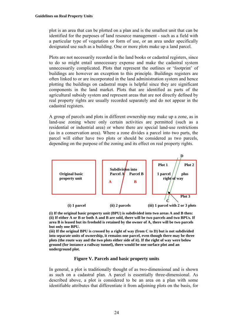
Guidelines on Real Property Units
plot is an area that can be plotted on a plan and is the smallest unit that can be identified for the purposes of land resource management - such as a field with a particular type of vegetation or form of use, or an area under specifically designated use such as a building. One or more plots make up a land parcel. Plots are not necessarily recorded in the land books or cadastral registers, since to do so might entail unnecessary expense and make the cadastral system unnecessarily complicated. Plots that represent the outlines or ‘footprint’ of buildings are however an exception to this principle. Buildings registers are often linked to or are incorporated in the land administration system and hence plotting the buildings on cadastral maps is helpful since they are significant components in the land market. Plots that are identified as parts of the agricultural subsidy system and represent areas that are not directly defined by real property rights are usually recorded separately and do not appear in the cadastral registers. A group of parcels and plots in different ownership may make up a zone, as in land-use zoning where only certain activities are permitted (such as a residential or industrial area) or where there are special land-use restrictions (as in a conservation area). Where a zone divides a parcel into two parts, the parcel will either have two plots or should be considered as two parcels, depending on the purpose of the zoning and its effect on real property rights.
A B
D Plot 1 Plot 2 Subdivision into Original basic Parcel A Parcel B 1 parcel plus property unit right of way
Plot 3 C (i) 1 parcel (ii) 2 parcels (iii) 1 parcel with 2 or 3 plots
(i) If the original basic property unit (BPU) is subdivided into two areas A and B then: (ii) If either A or B or both A and B are sold, there will be two parcels and two BPUs. If area B is leased but its freehold is retained by the owner of A, there will be two parcels but only one BPU. (iii) If the original BPU is crossed by a right of way (from C to D) but is not subdivided into separate units of ownership, it remains one parcel, even though there may be three plots (the route way and the two plots either side of it). If the right of way were below ground (for instance a railway tunnel), there would be one surface plot and an underground plot.
Figure V. Parcels and basic property units In general, a plot is traditionally thought of as two-dimensional and is shown as such on a cadastral plan. A parcel is essentially three-dimensional. As described above, a plot is considered to be an area on a plan with some identifiable attributes that differentiate it from adjoining plots on the basis, for
24

Guidelines on Real Property Units
example, of different land use or different taxable value (but not different real property rights, as this would make it a new parcel). A plot may constitute all or only a part of a land parcel. Likewise, there is no limit to the number of plots or parcels that make up a basic property unit or proprietary unit. In Norway and Finland for example, there are on average 1.7 parcels per BPU. The key element in a BPU is that it is registered as one unit in the land book or cadastre.
The BPU and the parcel are both defined by real property rights. The BPU is a legal entity and therefore an abstract concept that relates to specific areas of land called parcels. The parcel is something physical that can be delineated (unless covered by water) and measured by a surveyor. Parcels can contain both dry land and areas covered by water and in many jurisdictions can consist of water only, without any dry land.
When asked whether a basic property unit can consist of more than one parcel, 18 countries replied (Y = Yes; N = No): AT BE CH DE FI GR HR LT LV NL NO PO RU SE SK SI UK UAY Y N Y Y N Y N Y Y Y Y Y Y Y Y Y N
BPU (1) BPU (2) BPU (3) In 1 there is a house and garden – one BPU, one parcel and one plot In 2 the garden area is identifiable – one BPU, one parcel and two plots (the house and the garden; the white area around the house is here treated as part of the house) In 3 the garden is geographically separate – one BPU, two parcels and two plots
Figure VI. Plots
To summarize from the top, one person may own : • A portfolio of ownership.
25

Guidelines on Real Property Units
• The portfolio may consist of several proprietary units (most frequently referred to as several properties).
• The proprietary unit may consist of several BPUs. • The BPU may consist of several parcels. • Each parcel may consist of several plots.
In most cases, a “property” consists of only one BPU, which in turn is made up of only one parcel and one plot.
Plot Plot
Plot Plot
Parcel Parcel
Parcel Parcel
Parcels are made up of one or more plots
Basic property units are made up of one or more parcels
BPU BPU
BPU BPU
Proprietary units may be made up o one or more BPUs
PU or BPU
PU or BPU PU or
BPU
Portfolios of ownership are made up of one or more BPUs or proprietary units (PUs)
The plot and the parcel have a physical shape and are land-based. The parcel is defined by a homogeneous set of real property rights. The BPU and the proprietary unit are in principle abstract and based on single ownership. The BPU has homogeneous real property rights, the proprietary unit may not. The portfolio of ownership is a collection of proprietary units and BPUs.
Figure VII. The hierarchy of ownership
C. Multiple parcels and multiple owners An original property unit of land may become fragmented over time in one of two ways: multiplicity of parcels and multiplicity of landowners. Multiplicity of parcels arises where there is one owner of a series of separate parcels. Multiplicity of owners occurs where several people are the proprietors of one parcel with the ownership either being in the form of shares or as a joint
26

Guidelines on Real Property Units
tenancy. A condominium may involve share ownership with an original volume of space being divided into a series of parcels, one relating to the common parts of the building and the remaining parts being in the private ownership of the individual residents. The common parts may belong to an individual who is the absolute owner of the whole block but who leases out separate parcels to tenants. Alternatively, the common areas may be owned in shares held by the tenants of the separate apartments, each owner having certain voting rights and financial obligations depending on the size of the shareholding. If a shareholder dies, a new purchaser will be found to take over his or her share entitlement. The division of real property into shares may also occur under systems of inheritance in which properties are divided between the heirs in accordance with certain laws, rules and customs - such as under Islamic Shariah, which for example prescribes the number of shares to be allocated to widows, sons and daughters. The rights in real property may also be held either in the name of an organization that is a legal entity representing a group of people or jointly among individuals. Joint tenancy most commonly arises where a husband and a wife have joint ownership of their home; if one partner dies, the full property will automatically pass to the surviving spouse, unless there is a legal contract or law to handle it in another way. Multiple ownership can also arise through easements so that sections of an individual property may be subject to overriding interests. A group of landowners in Norway may, for example, have a right to hunt across a farmer’s land although the ownership of the farm is in an individual’s private hands. The public at large may have a right of way across a piece of land or, as in Greece, named individuals may have the right to take certain produce such as olives from trees on someone else’s land. Multiplicity of ownership makes dealing in land more difficult as the agreement of all parties concerned may be needed before any further transaction can take place. Trustees may be appointed to facilitate matters, the trustees being authorized to act on behalf of the individual shareholders.
D. Fragmentation of areas A unit of ownership may be shared among different people (‘multiplicity of owners’) or divided into different adjacent or non-adjacent parcels (‘multiplicity of parcels’). The most common cause of the land being broken up into a series of small parcels (known as fragmentation of areas) is the system of inheritance under which land is subdivided among the heirs. A man may have three children and divide the land equally amongst them when he dies. They in turn may each have three children and, hence, in the next generation the single parcel of the grandfather becomes nine separate parcels belonging to his grandchildren. They in turn may exchange, sell or buy other
27

Guidelines on Real Property Units
pieces of land and within a couple of generations there may be many more parcels belonging to his heirs. In Slovakia, for example, there have been examples of land that was originally in one ownership and still is farmed by one individual but whose use rights come from over one thousand heirs of the original landowner. The area of land left to some of these sub-owners is little more than the size of an A4 sheet of writing paper but they have land rights even though the physical identification of their miniscule area is virtually impossible. The existence of multiple parcels can be beneficial in providing diversification. A farmer can grow a diversity of crops so that if one crop fails another may succeed. A farm that has a variety of soil types and climatic conditions may succeed where a monoculture system carries a higher risk of failure. In some cases fragmentation of land parcels is arbitrary and illegal (de Soto, 2000), while in others it may be recognized by the authorities and approved by the cadastre. Fragmentation may, however, discourage the best use of the land, since the size and location of land parcels may make them expensive to farm or otherwise exploit. There is then a need for land consolidation, a process that involves reassembling the land into more economic units. This may be driven by market forces or be orchestrated by the government. There is a divergence of views as to whether, given an open, efficient and inexpensive land market, it is possible to reassemble land into more economically viable units using market forces alone. Some people believe that this is the most efficient and least controversial way to achieve reforms, whereas others consider that the market operates too slowly and the State must intervene to stimulate and organize the reforms. Whether State- or market- driven, the effect of land consolidation is to alter the size and shape of land parcels. Fragmentation may also take place as a result of development, as has happened in those countries that during the communist era saw the withdrawal of individual real property rights. Building and road construction took place across old property boundaries, which consequently became obliterated. When the process of land restitution began, it was no longer possible to restore the old boundary lines, as they passed through sections of substantial buildings, contained parts of the modern road network, etc. This has been a problem, for instance, in areas of the former German Democratic Republic and in Latvia. In Hungary, very small pieces of land have had to be exchanged in order to reassemble the area for new development. This process has proved expensive and the cost of land transfer has been a significant deterrent to land consolidation (UNECE, 2001).
28

Guidelines on Real Property Units
Fragmentation of areas can be prevented through the development control process, placing the responsibility on the physical planning authorities. In Austria, for example, the law forbids the subdivision of land in some areas, for instance a parcel must cover a certain percentage of a hectare if it is to have a house built on it or have a minimum number of hectares for an economically viable unit for forestry or agriculture.
Before After
Figure VIII. Fragmentation: one farmer’s holdings before and after land consolidation
E. Boundaries Each parcel must be delimited by a boundary. From a legal perspective, a boundary is an invisible surface that differentiates one set of real property rights from another. Normally, this will be a vertical surface, although in the case of three-dimensional property rights or strata titles it may be horizontal. When the boundary is a vertical surface, it intersects the ground along what is called the boundary line, which is normally represented by a line drawn on a cadastral plan. Anyone stepping over the boundary line moves from one jurisdiction to another, in effect passing through an invisible curtain between the two sets of real property rights. The actual physical location of a boundary line is normally demarcated in one of two ways: by point features such as pegs the straight line between which marks the divide between two properties, or by linear features such as walls, hedges and fences. In some cases, for instance in open-planned development or in water areas, there is no physical evidence of the boundary. Its location can be deduced only from written details in the registers or from plans that show where the boundary lies in relation to identifiable physical features. Thus a boundary may be described as 50 metres from the edge of a lake or 10 metres from the front of a building, as shown on a cadastral plan. Coastal boundaries are normally defined in relation to the line of high tide, or in the case of Greece, where there is scarcely any tide, the extent of ‘high winter waves’. The United Nations Convention on the Law of the Sea lays
29

Guidelines on Real Property Units
down various agreements as to how to determine the limits of territorial seas and economic zones. The physical evidence of boundaries has an important social function in showing the limits of any individual’s territory. Where linear features are used to show the position of boundaries, fences are still regarded in law as items of defence and guards against intrusion. Hence, the line of the legal boundary may not necessarily be the same as that which is marked physically on the ground. In the general boundary system, as for instance practised in the United Kingdom, the precise line of the legal boundary – as to whether it is one side of the fence or the other or down the middle – is left as undetermined. This in effect means that the ownership of the boundary feature is not registered. Such an approach works equally well with three-dimensional properties such as apartments since their construction defines their effective limits. The precise boundary between the ceiling of an apartment and the floor of the one above it is left undetermined. The cost of surveying what are in effect approximate boundaries can be significantly lower than the cost of more precise surveys. In some jurisdictions, Lithuania for example, the law defines how boundaries should be marked, while in others there is less prescription and a combination of points and lines may be used. In the Netherlands, the landowners are asked to delimit their boundaries before the surveyors from the Kadaster measure them.
When asked whether the law defines how boundaries should be marked, 18 countries replied (Y = Yes; N = No): AT BE CH DE FI GR HR LT LV NL NO PO RU SE SK SI UK UAY N Y Y Y N N Y N N Y N Y N Y Y N N
When the physical evidence of a boundary line is moved, for example when a fence has to be re-erected on a slightly different line, it does not necessarily follow that the legal position of the boundary will change. The legal alignment can change only through due processes of the law. When such a change is formally agreed, in some jurisdictions the old parcels will be cancelled and two new parcels will be created. In others the old parcels remain but with slightly altered boundaries. When a parcel is subdivided into two new areas, in some countries two new parcels will be created, while in others one part of the old parcel will retain its old identity but with modified boundaries and only one new parcel will be created. In the Netherlands, all parcels have defined boundaries. Where there is no determined boundary, there is no parcel and, hence, the extent of any rights that relate to a part of a parcel, such as rights of way or other easements, may be found only by reference to the written evidence.
When asked if, on subdividing a parcel, two new parcels will be created (rather than one old parcel and one new parcel) 18 countries replied (Y = Yes; N = No):
30

Guidelines on Real Property Units
AT BE CH DE FI GR HR LT LV NL NO PO RU SE SK SI UK UAN Y N Y N Y Y Y N Y N Y Y N N Y N Y
In many land registers and cadastres there is numerical information about the dimensions of parcels, such as their area or the lengths of the boundary lines or survey data such as the coordinates of the corners of properties. Some numerical data may be guaranteed by the State, although in many jurisdictions the data are an aid to the identification of the boundaries rather than a guaranteed commodity.
31

Guidelines on Real Property Units
VI. IDENTIFIERS
A. Cadastral identifiers Every basic property unit and parcel recorded within a cadastre or land book register must have an identifier. In most jurisdictions where there are separate cadastre and land book systems both agencies use the same identifier although this is not inevitably the case. In England and Wales, for example, the national mapping agency (the Ordnance Survey) allocates numbers to fields on the basis of their coordinate values, while the Land Registry has its own numbering system. There are many different ways in which a reference can be given to a basic property unit. Most are products of national history and geography and were not designed for the computer age. Since almost all cadastres and land books have been or are being computerized, each data element needs to have its own unique identifier for the internal workings of a database management system. These identifiers are normally meaningless to human beings and will not be considered in these Guidelines. They allow information to be retrieved on the basis of a variety of characteristics including:
• The known identifier of the parcel or basic property unit; • Names and further information of owners (persons, organizations); • Addresses (postal addresses or other references); • Map displays (cadastral or topographic); • Coordinates.
From a human perspective, two forms of identifier can be used – a basic property unit identifier and a parcel identifier. Both identifiers are sometimes referred to as PIDs (P = property or parcel, ID = identifier). As discussed in chapter V, these may or may not relate to the same thing since a basic property unit may be made up of one or more parcels. Because of the possible confusion, the acronym PID will not be used in these Guidelines. One method for identifying a basic property unit is to use the name of the owner in what is sometimes called a grantor/grantee index. The grantor is the person by whom a grant or sale is made, while the grantee is the recipient - as in vendor/vendee or seller/buyer. The success of such an identifier depends on whether the names of such persons are known and are unique. Confusion can arise when a person’s name is spelt in different ways or changes (for instance on marriage), or is a common name shared by many people. A grantor/grantee index allows land register records to be searched on the basis of the name of the person who was the owner or the person to whom the real property has been sold. This is especially helpful in a deeds registry system. The maintenance of such registers used to be a tedious process but with modern database management systems it is generally straightforward, although its use may be contrary to laws governing data protection. Many countries, for example, allow members of the public to find out who is the
32
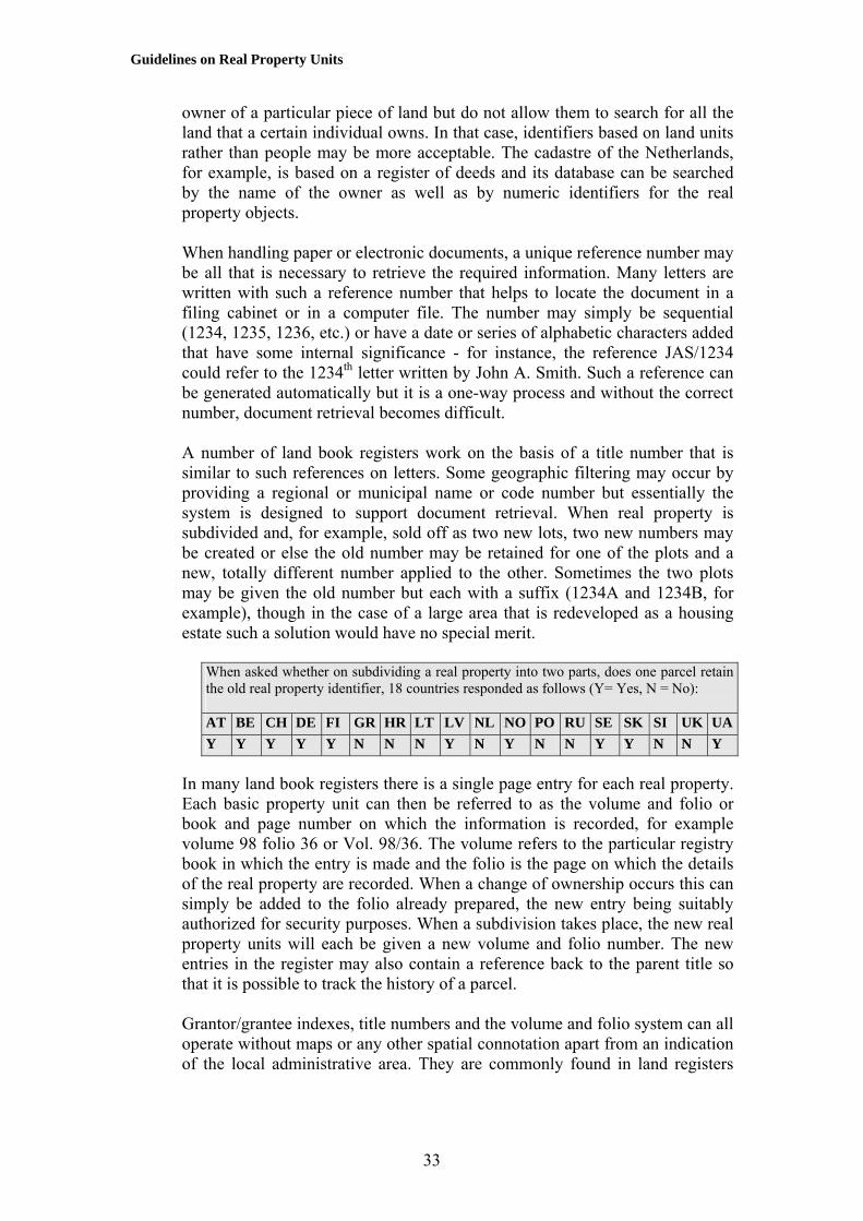
Guidelines on Real Property Units
owner of a particular piece of land but do not allow them to search for all the land that a certain individual owns. In that case, identifiers based on land units rather than people may be more acceptable. The cadastre of the Netherlands, for example, is based on a register of deeds and its database can be searched by the name of the owner as well as by numeric identifiers for the real property objects. When handling paper or electronic documents, a unique reference number may be all that is necessary to retrieve the required information. Many letters are written with such a reference number that helps to locate the document in a filing cabinet or in a computer file. The number may simply be sequential (1234, 1235, 1236, etc.) or have a date or series of alphabetic characters added that have some internal significance - for instance, the reference JAS/1234 could refer to the 1234th letter written by John A. Smith. Such a reference can be generated automatically but it is a one-way process and without the correct number, document retrieval becomes difficult. A number of land book registers work on the basis of a title number that is similar to such references on letters. Some geographic filtering may occur by providing a regional or municipal name or code number but essentially the system is designed to support document retrieval. When real property is subdivided and, for example, sold off as two new lots, two new numbers may be created or else the old number may be retained for one of the plots and a new, totally different number applied to the other. Sometimes the two plots may be given the old number but each with a suffix (1234A and 1234B, for example), though in the case of a large area that is redeveloped as a housing estate such a solution would have no special merit.
When asked whether on subdividing a real property into two parts, does one parcel retain the old real property identifier, 18 countries responded as follows (Y= Yes, N = No): AT BE CH DE FI GR HR LT LV NL NO PO RU SE SK SI UK UAY Y Y Y Y N N N Y N Y N N Y Y N N Y
In many land book registers there is a single page entry for each real property. Each basic property unit can then be referred to as the volume and folio or book and page number on which the information is recorded, for example volume 98 folio 36 or Vol. 98/36. The volume refers to the particular registry book in which the entry is made and the folio is the page on which the details of the real property are recorded. When a change of ownership occurs this can simply be added to the folio already prepared, the new entry being suitably authorized for security purposes. When a subdivision takes place, the new real property units will each be given a new volume and folio number. The new entries in the register may also contain a reference back to the parent title so that it is possible to track the history of a parcel. Grantor/grantee indexes, title numbers and the volume and folio system can all operate without maps or any other spatial connotation apart from an indication of the local administrative area. They are commonly found in land registers
33

Guidelines on Real Property Units
and can be applied to both basic property units and parcels. In the cadastre the focus tends to be specifically on the land parcel. Many cadastres use a block-and-plot numbering system, the block being an administrative area, an area marked on the map for the convenience of registration (for instance defined by the local road network) or an old farm or estate that has over time been subdivided. The Block is outlined on the cadastral map and within it each real property or parcel is given a unique number. When further subdivision takes place, new numbers will be allocated and either the old number is retained for the remaining parcel in the subdivision or else it, too, is given a new unique number. In the days when cadastral maps were produced manually, difficulties could arise in maintaining the maps if a large number of subdivisions had taken place. This is not such a problem for users of a computerized system.
Examples of basic property unit identifiers AUSTRIA (and similarly in CROATIA) Parcel ID: 20018-123/23 (Cadastral unit identifier plus the number of the parcel. The Cadastral unit identifier consists of five digits: provincial code (first digit); competent district court (second and third digit); and cadastral unit (last 2 digits). The codes remain unique keys in the sense of a database system even when mergers of administrative offices occur.) DENMARK The Danish cadastral identifier is a compound of a number and small letters, like 2df. Each parcel has a unique number within a specific defined area. Prior to April 2001, the same number could be attached to several parcels within the same area, but now each parcel must have a unique number within a specific defined area. The numbering system does not apply to all parts of Denmark for historical reasons. FINLAND BPU ID: 123-223-3-44 (Municipal code, location code, group code (block or house), unit code (lot or register unit.) GREECE: Parcel ID: 22-333-22-22-333 (Prefecture (2 digits)-municipality (3)-cadastral sector (2)-cadastral section (2)- parcel (3).) LATVIA: Parcel ID: 01000030002 (0100 = code of cadastral territory; 003 = code of cadastral group; 0002 = unique number in cadastral group (from 0001 - 9999).) LITHUANIA: Parcel ID: 4400-0004-4230 (the unique code) (Each land parcel has a unique number consisting of 12 digits including 1 control number. The digits have no special significance.) Cadastral address: 5203/0003:4 (5203 = code of cadastral unit; 0003 = code of block; 4 = parcel number in the block (unique within the block).) RUSSIAN FEDERATION: Parcel ID: 50:13:03:001 is the first parcel in cadastre block 3 in Chimki rayon (13 = the number of the cadastre rayon) in Moscow region (50 = number of cadastre okrug). SWEDEN: Parcel ID: Haninge Svartsö 3:49 where the municipality, township or village is
34

Guidelines on Real Property Units
named, followed by the block number and BPU number.
In the Finland, the Netherlands and Sweden there is no specific identifier for the proprietary unit or portfolio of ownership. Only parcel (Netherlands) or BPU (Finland and Sweden) identifiers are used, leaving it to the database management system to assemble all the parcels that go to make up a portfolio of ownership within a certain area or region, or across the whole of the country. In Norway, where a BPU may consist of several parcels, often at different locations, the parcels are not given unique parcel identifiers; the number of the BPU is used to number the parcels, hence several parcels may have the same identifier. The block-and-plot system means that, after inspecting the cadastral index map to ascertain the real property reference number, the remaining information about the property can be obtained from the cadastral text registers. The blocks may not necessarily coincide with administrative boundaries so that it may not be immediately apparent within which municipal authority each real property lies. This can also happen when municipal boundaries change.
B. Building and apartment identifiers Buildings may or may not be recorded in separate parts of the land registers. Latvia, Lithuania and Sweden, for example, record buildings in separate registers, while in Austria, Croatia and the United Kingdom the land registries show buildings as parts of the parcels. In Greece buildings are recorded as a separate layer in the real property database. In Finland they are recorded in a separate building and dwelling information register kept by the Population Register Centre. The Norwegian system is known as GAB – ground, address and buildings. In Norway only buildings over 15 square metres are registered, while in Greece the determining factor is whether the building can be seen on an aerial photograph, hence ‘buildings’ 0.5 m by 0.5 m may be recorded. The legal definition of a building varies. For instance, in Norway a building should have at least three walls and a roof, while in Lithuania the Law on Construction states that a ‘building’ means ‘a work of construction with a roof and which contains one or more rooms or other premises, situated within the walls and partitions and used for living or agricultural, commercial, cultural, transport or other activities’. According to the Lithuanian Law on the Real Property Cadastre, an apartment (flat) means ‘a part of a dwelling or non-dwelling building which is arranged into dwelling premises, consisting of one or several rooms and auxiliary premises with a separate exit to the outside or premises of common use’. In Croatia a building is anything attached to the ground that is made in the building process; an apartment is part of a real property unit and is an independent functional unit. In Norway each building is identified by a 9-digit number that is unique within the country. This means that a building maintains its identifier even when on
35

Guidelines on Real Property Units
subdivision of the land the building becomes attached to a new parcel with a different parcel number. It also means that buildings can be numbered even when the parcel on which it stands has no known identifier. The allocation of numbers to buildings is often the responsibility of the local municipality, although in Slovenia it is the task of the Surveying and Mapping Authority. In most cases for the purposes of land administration it is not appropriate to number buildings by using the postal address since not all buildings will have such an address. In addition postal addresses often include a house number given to each entrance on the ground floor, in which case a building with several entrances will have several postal addresses. Identification of buildings by their street addresses makes it easy for people to identify properties on the ground, but can give rise to difficulties in land administration if, for example, street or building names are changed. For the purposes of land administration a stable address is necessary but postal addresses often change.
Examples of building identifiers
FINLAND
Every building has a separate identifier (real property unit ‘id’ + “D” + number) while the identifier for an apartment is derived from the building identifier (building ‘id’ + “N” + number).
GREECE In the case of buildings within a parcel, a sequential number is used in addition to the parcel ID (see previous table), to identify each building within the parcel. A similar logic is used to identify apartments. Specifically, the identification code of an apartment is comprised of the parcel code (12 digits) and a sequential number that characterizes the apartment within the parcel.
LATVIA Building property ID: 01005030006 (0100 – code of cadastral territory; 503 - code of three figures, summarize to 500; 0006 – unique number in cadastral group numbered from 0001 – 9999.) Apartment property ID: 01009000001 (0100 - code of cadastral territory; 9000001 - unique number in cadastral group that can have a value between 9000001 – 9999999.)
LITHUANIA Building property ID has a unique 12-digit number, e.g. 4400-0004-4308 Apartment property ID has a 16-digit number, e.g. 1300-0007-5022:0031
SWEDEN: Building property ID: Haninge Svartsö 3:49,002 where the number of the building (002) is added to the cadastral parcel ID.
In general the allocation of numbers to apartments within a condominium can give rise to difficulty, as there are no standard rules. Several countries have issued addresses to all apartments, including rental apartments and apartments in condominiums, for instance to enable statistical data about persons, families and other items to be linked to where people live. Many countries have successfully created apartment numbers from the floor number plus numbering
36

Guidelines on Real Property Units
of entrance doors from left to right on each floor. This assumes that there is an agreement as to whether the ground floor is the first floor or whether the first level above the ground floor is the first floor, and how to handle ‘half’ floors. Such a system of numbering may be unsatisfactory in condominiums that are separate properties because an apartment number built on the street address may not be permanent over time. Thus apartments in condominiums may need to have two numbers, one unique real property number that can be used in the registers and one street address number. Whatever system is adopted, it is important that it is rational and consistent.
As with buildings, an apartment address needs to be logical in relation to finding the way to the apartment, thus favouring the street / building address, but since this tends to change, it is not suitable for the registration of individual properties within condominiums. In Norway apartments within a condominium are given sub-numbers under the related BPU.
When asked whether buildings were recorded on a separate part of the land register, 18 countries replied (Y = Yes; N = No): AT BE CH DE FI GR HR LT LV NL NO PO RU SE SK SI UK UAN Y N Y N Y N Y Y N N Y Y Y N N N N
When asked whether a building can be registered as several sub-buildings, they replied: AT BE CH DE FI GR HR LT LV NL NO PO RU SE SK SI UK UAY Y Y Y Y Y N Y Y N Y Y Y N Y Y Y N
C. Cadastral plans From a number of perspectives the easiest way to identify a parcel is by reference to a cadastral plan. Such plans show the location of real property boundaries and in many cases the position of buildings. They may also incorporate other topographic data. Some plans show considerable detail about the size and shape of plots and parcels, including numerical data, while others act as an index showing where more detailed information can be found.
37

Guidelines on Real Property Units
Figure IX. Extract from a cadastral map of a rural area in Finland
38

Guidelines on Real Property Units
Figure X. Extract from an urban cadastral plan (thick lines) with topographic data (thin lines with red for buildings in the Netherlands)
Cadastral plans serve a variety of administrative purposes, especially when they show buildings. They allow tax authorities to check that all properties have been included in a valuation and to check the relationship between location and assessed value. They allow municipal authorities to manage their resources efficiently, since a graphic approach allows for overlays to be provided so that when using geographic information system (GIS) technology it is possible to display the plot under investigation and for the computer to assemble all the necessary information. This assumes that anyone wanting to enquire about real property has access to such a system. Often this is not the case, which is why simple systems such as street addresses are so important.
(a) An extract of a (b) Additional information (c) All the boundaries cadastral plan about boundary markers of parcel No. 399 digitized from have been fixed
old paper maps by coordinates
39

Guidelines on Real Property Units
Figure XI. Part of an Austrian cadastral map
Figure XII. Extract from a city cadastral plan in Lithuania
40

Guidelines on Real Property Units
Figure XIII. Section of an Austrian cadastral map with soils boundaries overlaid
D. Street addresses and postcodes The street address is the most common form of real property referencing system that is used by the general public. Normally it consists of the name of the street or road and a house number. The house number may be given to buildings, entrances or parcels with or without buildings. The street address is often used by the postal services and other forms of doorstep delivery. It evolved to meet an extensive range of applications and is used much more widely than the land-register-based address systems that grew up primarily for use within the land administration system. Street addresses are easy to understand but depend on the existence of a consistent street naming and building numbering system - something that is or has been lacking in certain areas of the world, including parts of Ireland until recently. There is also an assumption that street names do not change very often. Street addresses can be created easily when new streets are built, while the individual real property numbering system is usually under the control of the local municipality, which has an incentive to keep the system up to date so that it can deliver local tax bills and services. There are several systems in use for giving house numbers. The most common system in Europe is one where buildings or entrances on one side of the street have even numbers while on the opposite side there are odd numbers. In rural areas in Finland and Norway, buildings are given a number in accordance with the distance from where the road begins. A house located 1230 metres from the starting point of the road is given the number 123 if it is on the left side and 124 if it is on the right side of the road (the number reflecting the approximate distance to the nearest ten metres). This system facilitates numbering without a building plan for the entire area, and in practice there are always free numbers available for new houses.
When asked whether each urban real property has an official address, 18 countries replied (Y = Yes; N = No): AT BE CH DE FI GR HR LT LV NL NO PO RU SE SK SI UK UAY N Y Y N Y N Y Y N N Y Y N N N Y Y
A number of difficulties can, however, arise. Text-based addresses are not particularly easy to handle by computer. For example, the main street in the London district of Kensington is known both as Kensington High Street and as High Street Kensington. Humans have little difficulty with such a reversal of names but computers have to be specially programmed to cope with them. Additional problems can arise where municipal boundaries within a metropolis are changed so that one borough might have two roads named ‘High Street’. A number of different solutions occur. In Austria, for example, the address consists of the municipality, area, building number and postal annex. The
41

Guidelines on Real Property Units
municipality is responsible for maintaining the system. In future the addresses and the cadastral coordinates of the buildings will be linked via the cadastral index map and a geocode (fig.XIV). This will allow people to find any address with the coordinates in the cadastral index map. In Croatia the address is defined by the building entrance and consists of house number, street and municipality. The State Geodetic Administration allocates cadastral parcel numbers, while the municipality issues house numbers. Fields are regarded as belonging to a road or street or part of a municipality. In the built-up areas of Finland, there is an official street and house number and a postcode. The street address is defined by the municipality and in urban areas it is based on the town plan street name and building lot number. The Ministry of Domestic Affairs has given instructions to the municipalities on how the roads are to be named in the rural areas and how the numbering for houses is to be carried out from the starting point of each road then measuring in tens of meters. The Finnish Post has allocated each district (e.g. a municipality such as 21250 Masku), or subdistrict of a municipality (e.g. 00100 Helsinki) with a postcode, but these districts do not necessarily coincide with other administrative boundaries. In Sweden there is an official standard (SS637003) that describes the unique locating address unit, the ‘address-place’, as a separate object that connects the addressed feature with the locating address of the ‘address-place’, which is normally an entrance to a building. In the United Kingdom an initiative is in place to create a standard national address data set based upon the already established British Standard BS7666. The aim of this national land and property gazetteer is to support the delivery of citizen-based services by ensuring consistent addresses and providing a unique real property reference number for each address. In the urban and suburban areas of Greece, an address might be 47 Vas Sofias Avenue, 10676 Athens. In rural areas only the place name is used. Each building on one plot has the same address. This means that all apartments and shops in the same block of flats have the same address, the cadastral distinction between them being achieved by mentioning the numbering of the apartment. The local authority is responsible for street and building numbering and the Ministry of Transport for the postcode. In Lithuania the structure of the address is: municipality, residential area, street, (building, plot for constructing, garden plot) and premise. Every real property object is attributed to a residential area and municipality, although it may not have all these elements. Double addresses arise, for instance, with a corner building at a crossroads. Such building is attributed to each street and has a number in each street - for example, Janonio str.12 and Turgaus str.1 are the same building. Municipalities are responsible for allocating official addresses but there is no institution yet responsible for the maintenance of data on addresses, and there is no address register. From the perspective of guaranteeing ownership to real property that is clearly self-defined (such as a single apartment or a house with a permanent wall or
42

Guidelines on Real Property Units
fence bounding it) a postal address is often all that is needed. There may be separate reasons why an owner or the authorities want to know how many square metres are involved but if the real property is well defined then the title can be guaranteed and the owner can have security of tenure. Searching on the basis of local area can be speeded up if there is a national postcode system. The postcode is a series of letters and numbers that define a local area, working from large districts down to small areas. The first division is into regions, perhaps related to the nearest major town where there may be a post office sorting facility. Each region is then divided into subregions and these in turn are further subdivided into sub-subregions that are convenient for the delivery of mail. The system is thus hierarchical so that by entering the relatively brief letters of the postcode the search for real property can be narrowed down to perhaps 10 or 15 parcels. It is in effect a block-and-plot system with a logical and initially spatial structure. Unfortunately, as populations change, so can post codes. Experience in some countries has shown that when commercial companies move their premises they retain their original postcode for reasons of convenience and economy. Their location moves although their postcode address remains the same. So long as the post office officials understand where to find the new location, no harm is done. On the other hand companies that deliver location-based services will need to change the linkage between the postcode and its geography. The more serious objection to the use of street numbering and postcodes as identifiers for land parcels rather than attributes within a land administration system is that they apply only to areas where there are buildings. They do not apply to non-post office addressable objects such as individual fields in rural areas, although there is no inherent reason why the system should not be extended to such features. In Norway farms can be referenced by the distance in metres from the nearest village along a specified road but this still does not identify individual fields.
When asked whether each individual plot such as an identifiable field has an official address, 18 countries replied (Y = Yes; N = No): AT BE CH DE FI GR HR LT LV NL NO PO RU SE SK SI UK UAN N N N N N Y N N N N N N N N N N N
E. Geographic references There is increasing use of GIS technology, satellite positioning systems and other electronic position fixing devices that are capable of determining and processing data relating to the location of points to high levels of accuracy. There are many advantages to having a real property address system that includes some form of geographic reference since this facilitates spatial data analysis.
43

Guidelines on Real Property Units
The spatial reference of points may be given either in terms of their latitude and longitude or their rectangular grid coordinates. Latitude and longitude are traditional measures for navigation since they extend across the whole surface of the Earth. They have also been used to define some international and inter-State boundaries. From a mathematical perspective, they are relatively difficult to manipulate and although useful for plotting on charts they are, from a technical perspective, more complicated than a plane coordinate system. The most common spatial referencing system uses a regular grid with rectangular Cartesian coordinates. The coordinates of the corner of any real property boundary can then be given in terms of ‘x’ and ‘y’ and the whole boundary of a parcel described by a string of (x, y) coordinates. In some countries it is the convention to use ‘x’ to measure north and ‘y’ to measure east while in others the opposite is the case. A whole parcel can be given a reference by choosing one point within it, for example its centre, sometimes known as the seed point.
(x, y) y x Origin Figure XIV. The coordinates of the centre of a building
The coordinate of a point in the middle of the plot or building might be: X = 123, 456 metres and Y = 765, 432 metres from the point of origin of the reference system. These numbers may be calculated from other data such as the coordinates of the corners of the building or else be determined by eye. If necessary, these numbers can be combined in pairs as a single number (in this case 17 26 35 44 53 62) rather like a telephone number but giving the location of any real property to the nearest metre, 10 metres, 100 metres, kilometre, etc. depending on how many digits are considered. Although coordinates are not easy to remember and can be subject to human error, they are useful when it comes to processing within a computer. In the United Kingdom the Ordnance Survey ‘address point’ product provides
44

Guidelines on Real Property Units
coordinate values for over 20 million properties that have postal addresses and is used extensively for the purpose of locating properties. Coordinates can be extended to three dimensions by adding the height above the origin. Height is then in the z-direction so the coordinates become (x, y, z). It is unusual for cadastral systems to use three-dimensional coordinates even in a condominium. In Austria three-dimensional (3D) data are shown on separate graphic sheets, while in Finland there is no 3D cadastre - rights in the third dimension are handled as easements or usufructs and regulated by city plans. In Norway, on the other hand, properties that exist in 3D are indicated on the cadastral plan.
45

Guidelines on Real Property Units
VII. APPLICATIONS OF REAL PROPERTY IDENTIFIERS
A. Postcode geographies Postcodes as described in chapter VI are often used for the purposes of statistical analysis and for a variety of commercial applications. The area within an individual postcode often has a degree of homogeneity so that, for example, health or crime statistics or measures of social deprivation can be gathered and analysed at the postcode level. When the boundaries of each postcode area have been digitized the data can easily be mapped using GIS technology. In the Netherlands, for example, the postcode areas are generated automatically from the outer boundary of parcels with the same postcode. Mapping data at the postcode level can also allow for a degree of generalization that often, though not in all cases, avoids the disclosure of individual pieces of information that might be seen as a threat to privacy. Data can also be collected on a national rectangular grid square basis, with each real property being allocated, for example, to the nearest 100-metre grid square. This provides a quick and easy way to collate, analyse and display national census data. If the centre of a real property is allocated a coordinate reference or geocode, data at the household level can easily be combined within the appropriate grid square resolution (100 metres, 1 kilometre, 10 kilometres, etc.) to produce simple thematic maps.
Figure XV. Divisions by postcode Figure XVI. Divisions by grid square The lines formed by grid squares cut through properties, which usually do not conform to such geometrical regularity. The rectangular block system that is found in some of the cities and rural areas in the United States of America is alien to European planning and development, where the land use conforms more to the terrain than to cartographic convenience. The postcode system is more in tune with what happens on the ground. Even so anomalies can arise. As an example, parts of a postcode area may be in a flood plain and parts above it; if insurance companies offering flood protection base their analysis on the postcode they may deduce that this is an area of risk and deny insurance cover to someone whose home is within the
46
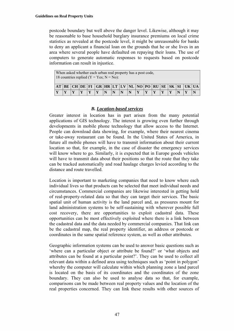
Guidelines on Real Property Units
postcode boundary but well above the danger level. Likewise, although it may be reasonable to base household burglary insurance premiums on local crime statistics as revealed at the postcode level, it might be unreasonable for banks to deny an applicant a financial loan on the grounds that he or she lives in an area where several people have defaulted on repaying their loans. The use of computers to generate automatic responses to requests based on postcode information can result in injustice.
When asked whether each urban real property has a post code, 18 countries replied (Y = Yes; N = No): AT BE CH DE FI GR HR LT LV NL NO PO RU SE SK SI UK UAY Y Y Y Y Y N N N N Y Y Y Y Y N Y N
B. Location-based servicesGreater interest in location has in part arisen from the many potential applications of GIS technology. The interest is growing even further through developments in mobile phone technology that allow access to the Internet. People can download data showing, for example, where their nearest cinema or take-away restaurant can be found. In the United States of America, in future all mobile phones will have to transmit information about their current location so that, for example, in the case of disaster the emergency services will know where to go. Similarly, it is expected that in Europe goods vehicles will have to transmit data about their positions so that the route that they take can be tracked automatically and road haulage charges levied according to the distance and route travelled. Location is important to marketing companies that need to know where each individual lives so that products can be selected that meet individual needs and circumstances. Commercial companies are likewise interested in getting hold of real-property-related data so that they can target their services. The basic spatial unit of human activity is the land parcel and, as pressures mount for land administration systems to be self-sustaining with wherever possible full cost recovery, there are opportunities to exploit cadastral data. These opportunities can be most effectively exploited where there is a link between the cadastral data and the data needed by commercial companies. That link can be the cadastral map, the real property identifier, an address or postcode or coordinates in the same spatial reference system, as well as other attributes. Geographic information systems can be used to answer basic questions such as ‘where can a particular object or attribute be found?’ or ‘what objects and attributes can be found at a particular point?’. They can be used to collect all relevant data within a defined area using techniques such as ‘point in polygon’ whereby the computer will calculate within which planning zone a land parcel is located on the basis of its coordinates and the coordinates of the zone boundary. They can also be used to analyse data so that, for example, comparisons can be made between real property values and the location of the real properties concerned. They can link these results with other sources of
47

Guidelines on Real Property Units
data so that people looking to buy particular types of real property can relate what is on offer with details of the local school, medical services or public transport systems. More importantly geographic information systems can be used to draw maps so that the results of any spatial analysis can be easily and clearly communicated to the non-specialist. Because of the personal nature of real property rights, there has been reluctance to integrate real-property-related data into the wider spatial data infrastructure of society. It is, however, becoming increasingly important to link real-property information with data sets such as those concerned with transport, energy supplies and the environment. Land and real property data need to be seen as part of the overall national picture and an important component in planning and managing sustainable development. The data collected by a cadastral agency can be used for purposes additional to those for which they were originally gathered. The municipality of Elefsis, a suburb of Athens, shows an example of the application of GIS technology to cadastral maps derived from the Hellenic Cadastre Project-11/2002 where the data were used in support of urban planning.
Figure XVII. Urban plan of Elefsis, Greece The diagram shows the cadastral land parcels and the different aspects of land use such as building zone, common use zone, schools/parks, etc, according to the valid urban plan The data can then be processed and displayed in a variety of forms, as shown in figure XVIII.
48

Guidelines on Real Property Units
Figure XVIII. 3D perspective representations of the area shown in figure XVII
The upper diagram shows the maximum permitted total “building area” for any specific land parcel according to the floor area ratio (FAR), as determined by the law. The lower diagram shows the actual floor area ratios as they currently exist.
49

Guidelines on Real Property Units
Part Three
BEST PRACTICE The following chapter summarizes the main findings of this report and identifies areas of best practice.
VIII. CONCLUSIONS AND RECOMMENDATIONS
A. Principles to be followed The benefits that can flow from a land administration system are dependent on a clear identification of the real properties that are registered and a simple and effective way of referencing them so that information about them can be easily retrieved. All countries have a system for real property referencing, though most such systems are based on historical factors including the traditional technologies used to draw paper maps and produce hand-written documents. These are being adapted to the electronic age. Changing old systems is difficult and expensive because it requires significant re-engineering of current practices and the conversion of existing records that were produced manually. Nevertheless some changes are necessary in order to accommodate the needs of the 21st century and the consequences of electronic data processing and the opportunities that this creates for handling three-dimensional real property units. Within Europe changes are also being stimulated by moves towards harmonization and the impact of such projects as the European Land Information Service (EULIS) that seeks to develop a system of seamless access to land information services across the whole of the continent. In addition, real property rights are becoming more complex as a result of the greater flow of information and more varied economic interests. Some rights and restrictions, especially those that address environmental protection, apply to all real properties while others affect only selected units. Some rights relate to buildings rather than to the land on which they stand. These rights run with the land and therefore should be regarded as part of the land. The responsibility for the control of many aspects of construction works, such as the right to build, the fabric of the structures or the heights of buildings lies with the municipal authorities. There must be links between the building registers and the land register so that any permission to build that is granted by a municipality is consistent with any other legal restrictions that are associated with the land on which it is to be constructed. Thus if there is a restrictive covenant on the land that expressly forbids a particular activity such as building above a certain height then this will be taken into account when an application for a building permit is lodged.
50

Guidelines on Real Property Units
Because of the connection between use rights and data held in the title registers, it is desirable that a parcel lies within one local government area. It is, however, impractical for all parcels in a basic property unit to lie within the same regulatory framework – for example all urban or all rural – since land use changes over time. When permission is granted, for example, for a house to be erected on land that is currently designated as agricultural, there is no need to change the BPU. This will happen only if the area built on becomes a formal subdivision and is sold or subject to a long-term lease to another party. Within these Guidelines:
• The term ‘parcel’ refers to the physical space that is identified in a cadastre. It is a closed polygon or more strictly a closed volume.
• A parcel is defined by uniform ownership and homogeneous real property rights. The parcel is the basic unit of area that is recorded in a cadastre.
• A parcel may consist of several plots, each of which belongs to one parcel.
• The plot is an area or volume that can be plotted on a map and is normally definable by the way in which the land is or may be used. It may or may not be identifiable in a cadastre.
• As a general rule, if an identifiable volume of space is or has been subject to a legal transaction, it is at least one parcel; if it is not or has not been subject to an independent transaction, it is a plot.
• A group of adjoining plots that belong to different owners but share the same characteristic may be regarded as a zone.
• A basic property unit (BPU) is defined by ownership and homogeneous real property rights, and may be made up of several parcels. It is the basic unit of ownership that is recorded in the land books or land registers.
• A proprietary unit consists of one or more BPUs that can be regarded as one property within which there are non-homogeneous real property rights.
• A portfolio of ownership is a collection of proprietary units and BPUs that are in the possession of one legal entity.
A proprietary unit arises where an original BPU may have been extended but where for historic or other reasons the additional components have not been amalgamated with the original. Consequently, there are different rights and the real property object is not homogeneous. In many cases, however, the proprietary unit and the BPU are the same thing. In urban areas a BPU is often made up of only one parcel and one plot. In rural areas, such as for a farm, a BPU may be made up of several parcels that are not adjacent to each other, each of the parcels having several plots. Some types of plots are the result of legal processes closely related to the cadastre, for example areas subject to servitudes with a permanent location such as a right of way. On the other hand, plots are more frequently the result of processes outside the control of the cadastral authorities, arising for example from
51

Guidelines on Real Property Units
physical planning (zoning), environmental protection, agricultural control, etc. Countries should be careful not to overload their cadastre with information about plots that may be of different provenance. Information about plots that refer to zoning, environmental protection, soil, vegetation, agricultural production, land use, etc. can be made available through the use of GIS techniques by matching information from different sources and displaying them as map overlays as and when the information is needed. This is preferable to recording the plots permanently in the cadastre, as there is a danger that too much data will be difficult to maintain. There is a growing need in the land market and elsewhere for information about public restrictions on land coming from physical planning, environmental protection, etc. It is, however, important that the cadastral authorities should prioritize the recording of real property units defined by ownership, namely the BPUs and parcels, and ensure that the cadastral information can be combined with information held in other databases. It is underlined that no other factor than ownership (freehold and leasehold) should be taken into account for the definition of parcels, and that any land administration system should contain up-to-date information about all existing parcels and BPUs. Although often recorded as areas marked on a cadastral plan, plots and more especially parcels are in fact volumes. Special problems arise with the administration of three-dimensional structures, for example where a road or railway passes underneath a building or where there are condominiums. The concept of land as a single unit becomes confusing when there are multiple owners having separate and joint interests in the one area. At first sight, a three-dimensional series of real property rights layered one on top of another runs contrary to the idea that land is a unitary object extending from below the ground up into the sky. However, where an apartment at for instance the third level in a block is the subject of a transaction, it will be the words in the transfer document that define and govern what is to be conveyed. These should state that it is only at that particular level that the ownership rights are to be transferred and that other land above and below in that horizontal plane is unaffected by the transaction. The entry in the register would then refer for instance to ‘the property registered and shown on the title plan comprises apartment number 12 on the third floor of Paradise Buildings’. Some legal difficulties can be overcome by the use of easements that allow part of the land to be used for a specific purpose, such as a right of way. This solution does not address the condominium, problem, for which separate legislation is needed. Joint tenancy of the common areas in an apartment block is an example of the multiple ownership of certain rights and obligations. Multiple ownership can arise through partnerships, such as marriage or commercial arrangement, or as a result of systems of inheritance where shares may be allocated to each of the heirs of an estate.
52

Guidelines on Real Property Units
The key to handling three-dimensional properties lies in dividing the volume of space that is involved into a number of parcels, some with separate owners with individual responsibilities and some having joint ownership or remaining with the overall real property owner. In many countries the municipalities have been responsible for common areas in apartment blocks, while the tenants or individual apartment owners were responsible for their particular areas of occupation, which in effect were their parcels. On the privatization of such apartment blocks, a new multiple owner has had to take over the former responsibilities of the municipality. The legal principles have not altered, although the management practice has changed. The ownership of water rights and the management of water resources will also require separate legislation. The extent to which individuals rather than the community can own areas of water differs between countries. All real properties have boundaries but the extent to which these are precisely determined varies very much from country to country. Some favour the exact delimitation of each real property, whereas others take a more pragmatic approach. Some require the physical limits of real properties to be defined by geometrically referenced points, while others rely on existing linear features such as fences or hedges. In some cases the lines drawn cartographically on a cadastral map or plan are sufficient to define the boundaries. The latter approach applies in particular to areas of open water where physical delimitation is impractical though it can also apply to dry land areas. The costs of precise geometrical surveys are relatively high compared with less demanding standards of cadastral survey. In some jurisdictions real property is legally defined by a survey, whereas in others it is the monuments that are used to demarcate the land that define a land parcel. With regard to the survey:
• A clear legal definition of what constitutes a real property and even a rudimentary means of describing each real property are essential and immediate requirements when introducing a system.
• Most of the benefits of a precise survey lie in the future. In the short term, clear and effective boundary demarcation is more important than precise survey.
• Surveys should be carried out to realistic levels of precision; unnecessarily precise geometric surveys will severely affect costs and levels of productivity.
• Survey is needed to control construction and development and is a long-term investment in case of subsequent dispute.
• A cadastral plan showing the layout of parcels is a valuable tool both for parcel identification and for development control.
• The cadastral plan can provide a link to other spatially related data and serve a variety of land resource management tasks including commercial and other location-based services.
53

Guidelines on Real Property Units
A cadastral map also provides a framework for parcel referencing. Parcel references need to be:
• Unique so that no two properties or parcels have the same reference. There must be a one-to-one correspondence between what is on the ground and what is on the registers and vice versa.
• Easy to understand so that there is little confusion and little likelihood of making mistakes. It is, for example, easy to misread numbers that are otherwise meaningless.
• Easy to remember so that landowners can correctly recall the identity of their properties.
• Easy to use both by the general public and by the cadastral and land book administration. They should also be easy to use by computer although how the computer handles any digital records internally is of no concern to the landowner and will depend on the database structure that has been adopted.
• Permanent so that the reference does not change unless the real property is to be subdivided.
• Capable of being updated when subdivision arises or when adjoining properties are amalgamated.
• Suitable for referencing plots within parcels. • Flexible so that they can be used for a variety of purposes within and
outside land administration, for example within local government. • Economic to introduce and cheap and easy to maintain. • Able to support archiving and permit historical review so that it is
possible to determine who was the owner of a certain real property on a certain date in the past.
• Maintained by one responsible legal authority. • Independent of parcel attributes that can be changed by other
responsible authorities (such as postcodes). Postal address systems are a proven way to identify individual houses but are not suitable for rural plots, especially where there is no street network, and in some cases are not permanent. The structure of a postal address should conform to some national standard so that there is consistency. The addition of a postcode not only helps the delivery of mail but also can be used for a variety of other commercial services. Consistency is important and the land book and cadastral authorities and municipalities should use compatible referencing systems. Indeed, for preference they should use the same system so that use rights, ownership rights and real property valuations can be linked together easily. The systems used by many cadastral authorities are hierarchically based around the cadastral administrative area, subdivided into blocks and then plots. Because of the problems of numbering subsequent subdivisions of a parcel it is important to have a cadastral plan that can help to identify the present parcel and its reference. The cadastral plan plays a significant role where different
54

Guidelines on Real Property Units
organizations are responsible for their own identifiers, since index maps based on the same spatial reference system can then be used as overlays to allow data integration. Geographical coordinate values facilitate the use of computer technology such as geographic information systems and survey data capture systems. Their structure is often too complex for normal human use; hence they should be an attribute belonging to a parcel rather than a basic real property reference.
B. Suggestions and recommendations
1. Spatial units There is no unique solution to the problem of defining and referencing real property units. Each country will develop its own solution that meets its own needs. In general, however, when defining real property units, good practice should include the following: 1. Land should be treated as a whole, allowing building rights to be a subset
of the rights that are associated with the land. 2. Definitions of the parcel and the basic property unit should be contained
in the land law. 3. The land law should define the extent of ownership vertically and
horizontally, both on dry land and for land under water. 4. Special legislation is needed to cover the management and responsibilities
of apartments and the common areas in a condominium. 5. Parcels should be defined by ownership. Each parcel should have unique
ownership and homogeneous real property rights. 6. The physical extent of parcels may be defined by survey or by physical
features on the ground; the legal extent is defined by real property rights. 7. Parcels should change only through due processes of the law. 8. Parcels should lie within one local administrative area, such as a
municipality. Where a basic property unit falls in two administrative areas it should be treated as having two parcels.
9. Based on the terminology used in these Guidelines, a basic property unit may consist of several parcels, each of which may contain several plots. In many cases the plot, the parcel, the BPU, the proprietary unit and the portfolio will be the same thing.
10. A plot is an area that can be plotted on a map and its extent may change over time, depending on the purpose for which it has been identified.
11. Only those plots that relate to the land market should be included within the cadastre.
12. It should be possible to link data about other forms of plot with the land administration data by having compatible data standards.
13. In particular, where for administrative convenience a separate building register is maintained, there should be a link between the building register and the land register.
14. A cadastral plan showing real property boundaries is a multi-purpose tool that can be used in the provision of a range of location-based services.
55

Guidelines on Real Property Units
2. Spatial references When referencing real property units, good practice should include the following: 1. The referencing system should be based on the needs of users and not on
the internal requirements of the computerized database management system that processes the land records.
2. The data in the register should be compiled on the basis of the land rather than the owner. Data retrieval, for example based on the name of the real property unit or on the name of the owner, should however be possible through the use of a database management system, provided this is not in breach of laws governing data protection.
3. The same parcel referencing system should be used in the land books, in the cadastre and in the municipalities so that real-property-related data can be easily integrated.
4. The reference that identifies a parcel should be unique. Two parcels should not have the same complete reference even when they are located in different districts or municipalities. (Partial references that are unique within the municipality may, however, be used so long as there can be no confusion with parcels in other municipalities.)
5. References to basic property units and parcels should be permanent over time. This may favour not using political or administrative areas as part of the real property identifier, because such areas may change for instance when municipalities are amalgamated.
6. For the same reason of permanence the parcel number should not be used as part of the building identifier.
7. A national standard for street (postal) addressing should be established. 8. Street addresses and apartment numbers should be designed primarily to
support the process of finding the relevant feature in the field, for example by supporting the delivery of goods and services at that address. They should be treated as attributes of parcels in the cadastral registers.
9. Apartments should preferably be given numbers that relate to the common ground-level entrance to the building. The apartment number will then consist of the street address plus its own reference number.
10. The address system should include a postcode that can be used for mail sorting and delivery and by commercial companies for marketing products and services and for data analysis.
11. There should be a national geodetic framework that can be used to provide the coordinates of boundaries and buildings.
12. Geographic coordinates of real property boundaries and any seedpoint that represents the middle of a parcel should be recorded in the registers as attributes of the parcel. GIS technology may then be used to search the data files on a location basis.
13. The referencing system must be simple and user-driven, and capable of being updated.
56

Guidelines on Real Property Units
Annex I
GLOSSARY OF TERMS Absolute title: an unconditional title for which no other person has a better right to the land. Abstract of title: a summary of documents and facts showing the ownership of a piece of land or real property. Adjudication: the process whereby the ownership and rights in land are officially determined. Adverse possession: the occupation of land inconsistent with the rights of the true owner. Alienation: the power of an owner to dispose of an interest in land or real property. In particular, land may be alienated from the State and granted to private individuals. Appraisal: estimating the market value or cadastral value (see below) of real property. Assessment: determining the tax level for real property based upon its relative market value. Assign: to transfer real property rights from one person to another, for example in a lease or mortgage certificate. Attribute: a characteristic of an object that may be used in its classification. Back-up copy: a duplicate that is made in case original data or software are destroyed. Base map: a general-purpose map upon which specific purpose maps are based. A base map is usually made with reference to the national geodetic framework (see below), and plotted in terms of the national coordinate system. Basic property unit: a land parcel (see below) or group of land parcels in one ownership. Boundary: either the physical objects marking the limits of real property or an imaginary line or surface marking the division between two legal estates. Also used to describe the division between features with different administrative, legal, land use, topographic, etc. characteristics.
57

Guidelines on Real Property Units
Cadastral index map: a map showing the legal property framework of all land within an area, including real property boundaries, administrative boundaries, parcel identifiers, sometimes the area of each parcel, road reserves, and administrative names. Cadastral map: a map showing land parcel boundaries. Cadastral maps may also show buildings. Cadastral surveying: the surveying and mapping of land parcel boundaries in support of a country's land administration, conveyancing or land registration system. Cadastral value: the value of a real property derived for tax purposes based on data held by the cadastre (see below) such as area, soil type, permitted use, etc., but not necessarily market value. Cadastre: a type of land information system that records land parcels. The term includes
• Juridical cadastre: a register of ownership of parcels of land; • Fiscal cadastre: a register of properties recording their value; • Land-use cadastre: a register of land use; • Multi-purpose cadastre: a register including many attributes of land
parcels. Caution or caveat: an entry in the registers or court records preventing certain actions being taken without notice to the person registering the caution or caveat. Charge: an interest in real property, for example when held as security for a debt. Civil law: the law laid down by the State regarding the rights of inhabitants. Also known as Roman law. Collateral: the use of real property as a guarantee for a loan. Common law: the unwritten law based originally on common customs and precedent but now administered by the courts. Condominium: the co-ownership of real property especially in a block of flats. Conservation area: a zone where there are special regulations on building and development in order to maintain the historical characteristics of the area. Consolidation: the planning and redistribution of land into units of more economic and rational size, shape and location. Contract: an agreement enforceable by law.
58

Guidelines on Real Property Units
Conveyance: a method whereby rights in land are transferred from one owner to another. The rights may be full ownership or a mortgage, charge or lease, etc. Customary law: unwritten law established by long usage. Customary tenure: the holding of land in accordance with customary law. Data: a raw collection of facts. Database: an organized, integrated collection of data held on a computer. Database management system: a set of programs for managing a database. Deed: a legal document stating the conditions under which land is transferred. Demarcation: the marking-out of the boundaries of each land parcel on the ground. Digital mapping (also known as automated cartography, or computer-assisted cartography): the processes of acquiring (capturing), transforming and presenting spatial data held in digital form. Digitizing: the process of converting graphic maps into digital form. Disaster copy: a copy of the register kept in a secure place in case the main register is damaged, for example by fire. Easement: a right enjoyed by one real property (the dominant tenement) over that of another (the servient tenement) for instance a right of access or for the passage of water or electricity. Emphyteusis: the holding of perpetual rights subject to an annual payment to the proprietor. Entity: an object about which information is stored in a database. Estate: in legal terms, an interest in land. The term is also used to refer to the physical land and real property to which that interest relates. Expropriation: the compulsory depriving of an owner of real property in return for compensation. File: an organized collection of related records. Fiscal value: the value of real property used for taxation purposes.
59
Guidelines on Real Property Units
Fixed boundary: the legal boundary of real property where the precise line has been agreed and recorded. Fragmentation: the division of land into units too small for rational exploitation, usually as a result of the system of inheritance. The process may lead to a multiplicity of parcels for one owner or many owners of one parcel. Freehold: a free tenure, distinct from leasehold, in which the owner has the maximum rights permissible within the tenure system. General boundary: a boundary for which the precise line on the ground has not been determined. General cadastre: an official public record usually recording the ownership rights, value and quantity of land in a jurisdiction or country. The legal land parcels are recorded in registers and on cadastral maps. Geocode: a numerical reference to a point (usually at the centre of a parcel) that is used to measure its geographic location. Geodetic framework or network: a spatial framework of points whose position has been precisely determined on the surface of the Earth. Geodetic survey: the process of determining the exact spatial position of points on the Earth's surface. The geodetic network is a basis for topographic, environmental and cadastral surveying and mapping. Geographic information system (GIS): a system for capturing, storing, checking, integrating, analysing and displaying data about the Earth that is spatially referenced. It is normally taken to include a spatially referenced database and appropriate applications software. Grant: a general word to describe the transfer of real property whereby rights pass from the ‘grantor’ to the ‘grantee’. Hypothec: a specific form of mortgage (see below) in which the loan is secured through a charge on real property. Information: data that have been processed into a form that is more suitable for the user. Land: the surface of the Earth, the materials beneath, the air above and all things fixed to the soil. Land administration: the processes of determining, recording and disseminating information about the ownership, value and use of land when implementing land management policies.
60

Guidelines on Real Property Units
Land information management: the managing of information about land. Land information system or service (LIS): a system for acquiring, processing, storing and distributing information about land. Land management: the activities associated with the management of land as a resource both from an environmental and an economic perspective. Land parcel: a single area of land, or more particularly a volume of space, under homogeneous real property rights and unique ownership. Land reform: the various processes involved in altering the pattern of land tenure and land use of a specified area. Land register: a public register used to record the existence of deeds or title documents. Land registration: the process of recording rights in land either in the form of registration of deeds (see above) or else through the registration of title to land (see below). Land tenure: the mode of holding rights in land. Land title: the evidence of a person's rights to land. Land transfer: the transfer of rights in land. Land use: the manner in which land is used, including the nature of the vegetation upon its surface. Land value: the worth of real property, determined in a variety of ways that give rise to different estimates of value. Leasehold: land held under a lease, that is, a contract by which the right of exclusive possession of land is granted by a landlord (the lessor) to a tenant (the lessee) for an agreed amount of money for an agreed period of time. Lot: a land parcel. Market value: the most probable sale price of a real property in terms of money, assuming a competitive and open market. Mass appraisal: the process of valuing a group of real properties at a given date, using standard methods. This may be based on estimated market prices at a certain date or on cadastral values (see above). Mortgage: the transfer of certain rights in a legal estate by a debtor (called the mortgagor) to a creditor (called the mortgagee) as security for a financial loan
61

Guidelines on Real Property Units
with the provision that those rights will cease when the loan is paid off by a certain date. The mortgage may be in the form of a written agreement or the deposit with the lender of the title deeds of the borrower’s land. Overriding interest: a legal interest in land that has legal force even though not recorded in the land registers. Parcel: a land parcel (see above). Plot: a component of a land parcel (see above) normally defined by the way in which the land is used and capable of being plotted on a map. Portfolio: a collection of properties held by a single owner. Prescription: the gaining of a right by reason of the passing of time. Private conveyancing: the transfer of rights in land without any public record of the transfer. Property: an object to which legal rights may be attached, especially rights of ownership; used in these Guidelines to mean real property (see below). Proprietary unit: a basic property unit (see below) or group of such units in one ownership that are regarded as one ‘property’. Provisional title: a registered title that should in due course become an absolute title provided that no objections are registered within a prescribed period. Real estate: land-related property. Real property: land and any immovable things attached to the land including buildings, apartments and other construction and natural objects such as trees. Real property administration: land administration (see above) Real property register: land register (see above) Real property registration: land registration (see above) Rectification: the legal process whereby errors on a land register may be corrected. Registered property: real property that has been recorded in the land register or the cadastre. Registration of deeds: a system whereby a register of documents is maintained relating to the transfer of rights in land.
62
Guidelines on Real Property Units
Registration of title: a system whereby a register of ownership of land is maintained based upon the land rather than on people (the owners) or documents (the deeds of transfer). Registry index map: a map showing all land that has been registered within a given area. Rental value: the value of real property in terms of the rent that may be derived from it. Restitution: the restoration of former rights in land involving the re-privatization of land and real property or the creation of new real property rights over land formerly taken over by the State. Restrictive covenant: an agreement whereby one landowner agrees to restrict certain ways in which the land may be used for the benefit of another. Root of title: a document dealing with the whole legal and equitable interest in real property that provides certainty in any legal disposition. Satellite positioning system: a system for fixing positions on the surface of the Earth by measuring the ranges to a special set of satellites that are orbiting around the Earth. Servitude: an easement or right of one real property over another. Spatial referencing: the association of an entity with its absolute or relative location. Stamp duty: a levy charged on the transfer of real property. Statute of limitations: a statute that limits the period during which a claim, for instance for the restoration of rights in land, can be pursued. Strata title: title to land that is not necessarily divided horizontally, such as in high-rise buildings or for mining rights. Subdivision: the process of dividing a land parcel into smaller parcels. Systematic adjudication: the determination of rights in land on a regular and systematic basis, for example within one area at one time. Tenure: the method whereby land rights are held. Title: the evidence of a person’s right to real property. Title deeds: documents giving evidence of title to land.
63

Guidelines on Real Property Units
Title plan: a plan especially drawn to show the boundaries of land parcels. Topography: the physical features of the Earth's surface. Usufruct: the use and profit from real property but not the real property itself. Valuation: the determination of the value of real property. Zone: an area of land that has different owners but some uniform characteristic such as an area subject to particular physical planning restrictions.
64
Guidelines on Real Property Units
Annex II
EXAMPLE OF INFORMATION IN A REAL PROPERTY REGISTER
The following information appears in the Lithuanian Real Property Register:
1. Identification of real property units: • Register No.; • Date of recording; • Version; • Address.
2. Real property objects (land parcel, building, premises, flat, utilities, etc.): (a) Land parcel: • Main objective purpose of land use; type of land use or business activity; • Unique number of an object; • Cadastral number; • Coordinates x, y; • Total area of land parcel; • Area of farming lands; • Reclaimed land; • Irrigated land; • Area of arable land; • Area of meadows and pastures; • Area of roads; • Built-up area; • Area of water land; • Area of other land; • Assessed value of a land parcel; • Date of assessment.
(b) Buildings, flats, other constructions: • Purpose of use; • Unique number of an object; • Number of rooms; • Total area; • Living area; • Area of basement; • Area of garage; • Number of floor; • Number of rooms; • Completeness; • Depreciation per cent; • Wall material;
65
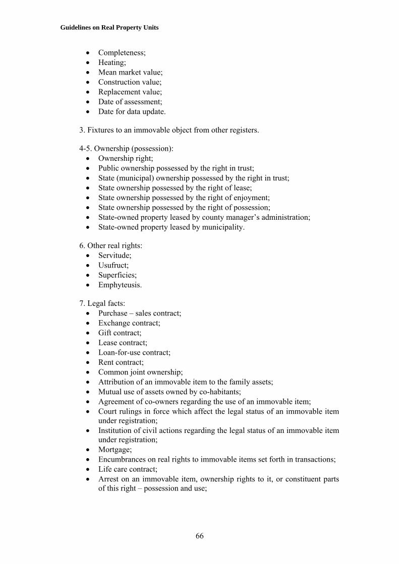
Guidelines on Real Property Units
• Completeness; • Heating; • Mean market value; • Construction value; • Replacement value; • Date of assessment; • Date for data update.
3. Fixtures to an immovable object from other registers.
4-5. Ownership (possession): • Ownership right; • Public ownership possessed by the right in trust; • State (municipal) ownership possessed by the right in trust; • State ownership possessed by the right of lease; • State ownership possessed by the right of enjoyment; • State ownership possessed by the right of possession; • State-owned property leased by county manager’s administration; • State-owned property leased by municipality.
6. Other real rights: • Servitude; • Usufruct; • Superficies; • Emphyteusis.
7. Legal facts: • Purchase – sales contract; • Exchange contract; • Gift contract; • Lease contract; • Loan-for-use contract; • Rent contract; • Common joint ownership; • Attribution of an immovable item to the family assets; • Mutual use of assets owned by co-habitants; • Agreement of co-owners regarding the use of an immovable item; • Court rulings in force which affect the legal status of an immovable item
under registration; • Institution of civil actions regarding the legal status of an immovable item
under registration; • Mortgage; • Encumbrances on real rights to immovable items set forth in transactions; • Life care contract; • Arrest on an immovable item, ownership rights to it, or constituent parts
of this right – possession and use;
66

Guidelines on Real Property Units
• Entry of an immovable item into the Register of Cultural Heritage; • Presence of an immovable item in the territory or the protection zone of
immovable cultural values; • Encumbrances on real rights to an immovable item set forth in the
Regulation for the Protection of an Immovable Cultural Value or special use terms;
• Other legal facts, if their registration in the Real Property Register has been provided for in legal acts.
8. Notices: • Restriction to change the main objective purpose of use; • Owner acknowledged as incapable; • Pre-emption right; • Pledge.
9. Special use conditions: • Protection zones of road, navigation, gas pipe, reserves, etc.; • Forest use restrictions; • Recreation areas; • Sanctuaries; • Soil protection.
10. Formation of real property object. 11. Register remarks and references. 12. Description: • Number of archive file.
The Real Property Register Central Databank contains notes about and provides references to appropriate documents: • National and regional parks; • Nature reserve areas; • Protection zones of sanitation, electricity lines, railways, gas and oil pipes; • Waters reserves; • Resort areas; • Geological, botanical, zoo, ornithological, etc. reserves; • Natural resources; • Nature monuments; • Areas exposed to flood; • Immovable cultural heritage; • Seaside strip; • Karstic region; • Areas exposed to landslide, subsidence; • Objects of the State border.
67

Guidelines on Real Property Units
References and additional material
Armstrong M. P., G. Rushton, R. Honey, B. T. Dalziel, P. de S. Lolonis and P. Densham. Decision support for regionalization: a spatial decision support system for regionalizing service delivery systems. Computers, environment and urban systems 15: 37-53, 1991.
CORINE http://www.geog.ucl.ac.uk/~alagouva/nomen.html Dale P. Cadastral surveys within the Commonwealth. London, H M Stationery Office
Government Bookshops, 1976. ISBN 0-11-880235 6. Dale P. and J. McLaughlin. Land information management. United Kingdom, Oxford
University Press, 1988. ISBN 0-19-858404-0. _____ Land administration. United Kingdom, Oxford University Press, 1999. ISBN
0-19-823390-6. Dale P. and R. Baldwin. Lessons learnt from the emerging land markets in Central
Europe. Proceedings FIG WW. Prague, 21-26 May 2000. De Soto H. The mystery of capital; why capitalism triumphs in the West and fails
everywhere else. Basic Books, 2000. ISBN 0-465-01614-6. Eckert J. (ed.) Property appraisal and assessment administration. International
Association of Assessing Officers, United States of America, 1990. ISBN 088329-081-2.
Federal Land Cadastre Service of the Russian Federation. Proceedings of the
workshop on mass valuation for taxation purposes. Moscow, 27-28 June 2002. International Federation of Surveyors (FIG). The FIG statement on the cadastre.
Frederiksberg, Denmark, FIG Office, 1995. Publication No. 11/1995. http://www.fig.net/
_____ The Bathurst declaration on land administration for sustainable development.
Frederiksberg, 1999. ISBN: 87-90907-01-9. _____ The Nairobi statement on spatial information for sustainable development.
Frederiksberg, 2002a. Publication No. 30. ISBN: 87-90907-19-1. _____ Land information management for sustainable development of cities; best
practice guidelines in city-wide land information management. Frederiksberg, 2002b. Publication No. 31. ISBN: 87-90907-21-3.
Hawerk W. Grundbuch and cadastral systems in Germany, Austria and Switzerland.
Proceedings of FIG com7 seminar. Delft, Netherlands, 1995. http://sunspot.sli.unimelb.edu.au/fig7/Delft_seminar_95/paper3.html
68

Guidelines on Real Property Units
HM Land Registry. Study on key aspects of land registration and cadastral legislation.
London, 2000. Produced and published on behalf of the UNECE Working Party on Land Administration.
_____ Inventory of land administration systems in Europe and North America. Third
edition. London, 2001. Produced and published on behalf of the UNECE Working Party on Land Administration.
International Valuation Standards Committee. International valuation standards 2001.
2001. ISBN 0-922154-68-6-X http://www.ivsc.org/pubs/index.html
Larsson G. Land registration and cadastral systems, tools for land information and
management. England, Longman Scientific and Technical, 1991. ISBN 0-582-08952-2. United States of America, John Wiley & Sons, 1991. ISBN 0-470-21798-7.
Moyer D. and K. Fisher. Land parcel identifiers for information systems. United
States of America, American Bar Foundation, 1973. ISBN 0-910058-58-X. Muggenhuber G. and R. Krieglsteiner. Customers’ access to cadastral data. JEC-
Congress, Vienna, 1997. Murray K. and C. Bray. Better connected; the three ordnance surveys improve
georeferencing links. Proceeding of the AGI Conference at GIS 2001. United Kingdom, 2001.
Potsiou C., M. Volakakis and P. Doublidis. (2001a). Hellenic cadastre; state of the art;
experience, proposals and future strategies. Computers, environment and urban systems 25: 445-476, 2001a.
Potsiou C. and J. Badekas. Preliminary analysis of the Hellenic cadastral data.
Proceedings of the Technical Conference FIG WW2001. Seoul, 2001. (2001b). http://www.fig.net/figtree/pub/proceedings/korea/full-papers/papers-index.htm
The need for public-public cooperation. By Potsiou and others. Workshop on
customers-cooperation services. Vienna, 12-13 September 2002. United Nations. Report of the Ad Hoc Group of Experts on Cadastral Surveying and
Land Information Systems. New York, 1985. United Nations. Economic Commission for Europe. Land administration guidelines
with special reference to countries in transition. 1996. 94 p. (ECE/HBP/96) Sales No. E.96.II.E.7.
_____ Social and economic benefits of good land administration. 1998.
(HBP/1998/8).
69

Guidelines on Real Property Units
_____ Guidelines on condominium ownership of housing for countries in transition.
2003. (ECE/HBP/123). Sales No. E.03.II.E.20. _____ Workshop on managing and developing effective land registration and
cadastral services. London, 23-24 September 1999. Report prepared by the delegation of the United Kingdom in cooperation with the secretariat. (HBP/WP.7/1999/5).
_____ Workshop on title registration systems and real property markets. Erevan,
10-13 October 2001. Report prepared by the delegation of Armenia in cooperation with the secretariat. (HBP/2001/11).
_____Workshop on customers-cooperation services. Vienna, 12-13 September 2002.
Report prepared by the delegation of Austria in cooperation with the secretariat. (HBP/2002/10).
Van Oosterom P. J. M., J. E. Stoter and E. M. Fendel (eds). 3D cadastres; registration
of properties in strata. Proceedings of the International workshop on 3D cadastres. Delft, Netherlands, November 2001.
70