guidelines for delineating - oneocean -- coastal...
TRANSCRIPT
1GUIDELINES FOR DELINEATING/DELIMITING MUNICIPAL WATERS

2GUIDELINES FOR DELINEATING/DELIMITING MUNICIPAL WATERS
3GUIDELINES FOR DELINEATING/DELIMITING MUNICIPAL WATERS
DENR Administrative OrderNo. 2001 - 17
SUBJECT: GUIDELINES FOR DELINEATING/DELIMITINGMUNICIPAL WATERS
Pursuant to Article 1 on National Territory of the 1987 Constitution, PresidentialDecree No. 1599 dated June 11, 1978, Section 123 of Republic Act 8550, otherwiseknown as the Philippine Fisheries Code of 1998, and Executive Order No. 192 datedJune 10, 1987, the following regulations and guidelines governing the delineation anddelimitation of municipal waters of the country are hereby promulgated:
Section 1. Basic Policy
It is the policy of the State to protect the rights of the people, especially the localcommunities with priority to marginal fisherfolks, in the preferential use of the municipalwaters. The delineation/delimitation of municipal waters will define the geographicextent of the city or municipality�s taxation or revenue-generating powers, its lawenforcement jurisdiction, resource allocation, and general management powers.
Section 2. Definition of Terms
For the purposes of this manual, the following definition of terms shall be used:
Adjacent municipalities � coastal municipalities sharing a common land boundarypoint on the coast.
Archipelago � a group of islands, including parts of islands, interconnecting watersand other natural features which are so closely related that such islands, waters,and other features form an intrinsic geographical, economic, and political entity,or which historically have been regarded as such
Awash � flush with or washed by waves
Baseline � the line from which the outer limits of municipal waters are projected
Basepoint � a point on land from which baselines are drawn
Cay � a low, flat island of sand, coral, or other material which is awash or driesduring low water
Coast � the edge or margin of land next to the sea
Coastal terminal point � a boundary point on the coast, common to two adjacentmunicipalities
Coastline � the line where the shore and water meet
Construction line � a temporary drawing line used in determining a final line, e.g.,a boundary line, or points used to determine that final line
Delimitation � the determination of boundaries of municipal waters between
4GUIDELINES FOR DELINEATING/DELIMITING MUNICIPAL WATERS
adjacent or opposite municipalities where the delineation of their respectivewaters show that their respective municipal waters overlap
Delineation � the determination of the outer limits of the municipal waters of amunicipality
Drying reef � a reef or part of it which dries at low tide
Fringing reef � a reef directly attached to the shore or located in its immediatevicinity
General coastline of the municipality � refers to the coastline of the mainland andoffshore and/or fringing islands of the municipality
High water or high tide � refers to the highest level reached at a place by thewater surface in one oscillation
Island � a naturally formed area of land, surrounded by water, provided thatwhere the island is surrounded by the sea, the same should also always be abovethe water at high tide
Lateral boundary � the municipal water boundary between two adjacentmunicipalities
Low water or low tide � refers to lowest level reached at a place by the watersurface in one oscillation
Low water line or low water mark � the intersection of the plane of low water withthe shore; the line along a coast or beach to which the sea recedes at low water
Mainland of the city or municipality � the land area of the municipality withinwhich the municipal capitol is located
Median line or equidistance line � a line every point of which is equidistant fromthe nearest points on the coasts of two municipalities
Municipal archipelagic baseline � a baseline used in cases where the municipalityis composed of islands or has offshore and/or fringing islands
Normal baseline � the baseline described by the coastline of a municipality,where such coastline is relatively smooth and simple and there are no outlyingor fringing islands, reefs, rocks, pinnacles, or other abutting features
Opposite municipalities � municipalities not sharing land boundaries but havingcoastlines which face each other and are less than thirty (30) kilometers apart
Pinnacle rock � a sharp pointed rock rising from the bottom, which may extendabove the surface of the water
Reef � a mass of rock or coral which either reaches close to the sea surface or isexposed at low tide
Rock � a formation of natural origin that constitutes an integral part of thelithosphere, which may or may not always be above high tide
Rock awash � rock awash according to chart datum (usually low water)
5GUIDELINES FOR DELINEATING/DELIMITING MUNICIPAL WATERS
Sandbar � a shallow portion of the coast, largely made of loose sand that is nearthe surface of the water
Shoal � an offshore hazard to navigation on which there is a depth of ten (10)fathoms or twenty (20) meters or less, composed of unconsolidated materialexcept coral or rock.
Straight baseline � a baseline used in cases where the coastline is deeply indentedor cut into
Tidal water � any water the level of which changes periodically due to tidalaction
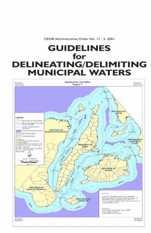
Section 3. Coverage
The coverage of this administrative order shall be all the municipal waters asdefined by Sec. 4(58) of RA 8550, which include, not only streams, lakes, inlandbodies of water and tidal waters within the municipality which are not includedwithin the protected areas as defined under RA 7586 (The NIPAS Law), public forest,timber lands, forest reserves or fishery reserves, but also marine waters includedbetween two (2) lines drawn perpendicular to the general coastline from pointswhere the boundary lines of the municipality touch the sea at low tide and a third lineparallel with the general coastline including offshore islands and fifteen (15) kilometersfrom such coastline. Where two (2) municipalities are situated on opposite shoresthat there is less than thirty (30) kilometers of marine waters between them, thethird line shall be equally distant from opposite shore of the respective municipalities.This administrative order shall not be construed to preclude special agencies oroffices in exercising their jurisdiction over municipal waters by virtue of special lawscreating these agencies such as, but not limited to, the Laguna Lake DevelopmentAuthority and the Palawan Council for Sustainable Development, pursuant to Sec. 17of RA 8550.
Section 4. Role/Responsibility of Agencies
In order to have an efficient and effective flow of activities in the delineation/delimitation of municipal waters, the role of the agencies involved are herein provided:
A. Department of Environment and Natural Resources (DENR)
1. As the mother agency, oversee the activities being conducted by NAMRIA;
2. Provide the implementation mechanism for the delineation/delimitation;
3. Provide assistance/support and participate in the conduct of public hearingthrough its field offices, units, agencies, programs, and projects.
B. National Mapping and Resource Information Authority (NAMRIA)
1. Delineate or delimit the boundaries of municipal waters on maps or chartsof appropriate scale as requested by the local government units;
6GUIDELINES FOR DELINEATING/DELIMITING MUNICIPAL WATERS
2. Provide the local government units proposed maps and technicaldescriptions of the maps before the conduct of the public hearing;
3. Approve the maps, charts, and technical descriptions as a result of thedelineation/delimitation of municipal waters;
4. Participate in public hearings and consultations conducted in relation to thedelineation/delimitation of municipal waters and take note of comments,inputs, suggestions, reactions or objections to the proposed delineation/delimitation;
5. Revise maps, charts, or technical descriptions as a result of the public hearing;
6. Approve an official copy of maps, charts, and technical descriptions andprovide the approved maps to the municipality/city concerned;
7. Provide technical assistance relevant to delineation and delimitation ofmunicipal waters;
8. Act as the repository of all technical descriptions and corresponding originalmaps or charts of all municipal waters;
9. Conduct actual verification of boundary limits as required.
C. Local Government Units
1. Request the NAMRIA to delineate/delimit the boundaries of their municipalwaters;
2. Conduct public hearings and consultations in relation to the proposeddelineation/delimitation;
3. Settle disputes with adjacent or opposite municipalities arising from thedelineation/delimitation through the Sangguniang Bayan/Panglungsod orPanlalawigan or in any appropriate body;
4. Enact ordinances setting forth the extent of its municipal waters, incorporatingthereof the maps or charts and technical descriptions.
D. Other Agencies and/or Entities
Other agencies and/or entities that are involved in the management anddevelopment of municipal waters should assist in the delineation/delimitation ofmunicipal waters. Information (map, technical descriptions, etc.) of areas undertheir administrative jurisdiction should be provided.
Section 5. Systems and Procedures
A. Requirements to Start Delineation Process
1. Filing of Request for Delineation
All requests for delineation and delimitation of municipal waters shallbe directed to the Administrator of the NAMRIA, through the Director
7GUIDELINES FOR DELINEATING/DELIMITING MUNICIPAL WATERS
of the Coast and Geodetic Survey Department.
A request may be made by any of the following:
a) a city or municipality individually or jointly with other cities/municipalities with whom common boundaries are shared,through a resolution of the Sangguniang Panglungsod orSangguniang Bayan;
b) a province on behalf of all of its coastal municipalities, througha resolution of the Sangguniang Panlalawigan;
c) a national government agency on behalf of any city ormunicipality, through a formal letter/request signed by thehead of the agency, but only with the conformity of the affectedlocal government unit/s, expressed in form of a resolution ofthe Sanggunian concerned which shall be attached to the letter/request.
A copy of the resolution or letter/request shall be furnished by theNAMRIA to:
a) the DENR Community Environment and Natural ResourcesOffice (CENRO) and/or the relevant DENR Regional Office;
b) the BFAR;
c) any adjacent or opposite municipality which may be affectedby the delineation and/or delimitation;
d) the Regional Office of the Philippine National Police MaritimeGroup (PNP-MARIG);
e) any special agency having jurisdiction over coastal waterswhich may be excluded from municipal waters in accordancewith the Fisheries Code (e.g. the Protected Area ManagementBoard (PAMB) with respect to areas under the NIPAS Act);
f) any affected private parties or sectors which the city ormunicipality may deem fit to notify.
2. Basic Technical Requirements for Requesting Entity
The filing of request for delineation must include basic technicalrequirements such as:
a) a list of known or named islands and maps of said islandsunder the jurisdiction of the municipality whose municipalwaters are to be delineated and delimited; and
b) a copy of the legislation/proclamation creating the municipalityor city.
8GUIDELINES FOR DELINEATING/DELIMITING MUNICIPAL WATERS
3. Response
The NAMRIA through the Director of the Coast and Geodetic SurveyDepartment shall schedule the delineation and delimitation of themunicipal waters of the municipality. A copy of the response shall alsobe furnished to any adjacent or opposite municipality, which may beaffected by the delineation and/or delimitation.
B. Procedure for Delineation and Delimitation of Municipal Waters
1. Delineation of Municipal Waters
a) Use of normal baselines
i. Where the coastline is not deeply indented or cut into, and thereare no outlying or fringing islands, reefs, or rocks, the normalbaseline shall be the low water line.
ii. The normal baseline shall determine the general coastline of themunicipality for purposes of delineation and delimitation.
iii. The outer limits of the municipal waters of the municipality shallbe determined by a line parallel to the normal baselines and fifteen(15) kilometers therefrom.
b) Use of straight baselines
i. Where the coastline is deeply indented and/or there are outlyingor fringing reefs or rocks, the outermost points of the coastlinemay be connected by straight baselines, provided that the lengthof such baselines does not exceed thirty (30) kilometers.
ii. In such cases, the straight baselines shall determine the generalcoastline of the municipality for purposes of delineation anddelimitation.
iii. Reefs, rocks, cays, shoals, sandbars, and any other features whichare submerged during high tide shall not be used as basepoints.Neither shall they have their own coastlines.
iv. The outer limits of the municipal waters of the municipality shallbe determined by a line parallel to the straight baselines and fifteen(15) kilometers therefrom.
c) Use of municipal archipelagic baselines
i. Where the territory of a municipality includes several islands,the outermost points of such islands shall be used as basepointsand connected by municipal archipelagic baselines, providedthat the length of such baselines shall not exceed thirty (30)kilometers.
9GUIDELINES FOR DELINEATING/DELIMITING MUNICIPAL WATERS
ii. The municipal archipelagic baselines shall determine thegeneral coastline of the municipality for purposes of delineationand delimitation.
iii. Islands, isles, or islets located more than thirty (30) kilometersfrom the mainland of the municipality shall have their ownseparate coastlines.
iv. Rocks, reefs, cays, shoals, sandbars, and other features whichare submerged during high tide shall not be used as basepointsfor municipal archipelagic baselines. Neither shall they havetheir own coastlines.
v. The outer limits of the municipal waters of the municipalityshall be enclosed by a line parallel to the municipal archipelagicbaselines and fifteen (15) kilometers therefrom.
d) Combination of baselines
A combination of normal and straight baselines, or normal andmunicipal archipelagic baselines, may be used depending on thecircumstances and in the interest of simplicity in determining thegeneral coastline and delineating municipal waters.
2. Delimitation of Adjacent Municipal Waters
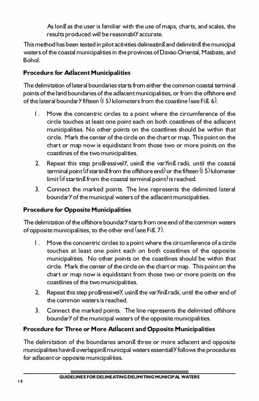
a) Where the general coastline is not curved or irregularly shaped at thecoastal terminal point of the land boundary common to two (2) adjacentmunicipalities, the lateral boundary shall be determined by a lineperpendicular to the general coastline at the terminal point.
b) Where the general coastline at the point where the land boundarytouches the sea is curved or irregularly shaped, making thedetermination of a perpendicular line impossible, the lateral boundarybetween two (2) adjacent municipalities may be determined by eitherof the following methods, depending on the complexity of the coastline:
i. Simplified bisection
The lateral boundary shall be determined as follows:
i.a) Examine the direction of the general coastline on both sidesof the common coastal terminal point. On each side of thecommon point, draw a straight line, a short baseline, whoselength shall be limited to the point where the direction of thegeneral coastline changes significantly or veers to anotherquadrant (see Fig. 1 for illustration).
i.b) Draw perpendicular lines to the coastlines on both sides ofthe common terminal point, passing through this common
10GUIDELINES FOR DELINEATING/DELIMITING MUNICIPAL WATERS
terminal point. Bisect the angle formed by the twoperpendicular lines. The bisector is the lateral boundary ofthe municipal waters between the adjacent municipalities.The bisector will extend to fifteen (15) kilometers if thecoastlines beyond the short baselines will no longer affect itsequidistance from both coastlines; otherwise, it will extendonly up to a distance beyond which the equidistance linemethod shall already be applied (see Fig. 1 for illustration).
ii. Equidistance line
The lateral boundary shall be determined by a line equidistantfrom the coastlines of the adjacent municipalities, as determinedthrough the use of the baselines under Paragraphs 1a through 1dof Section 5B.
3. Delimitation of Opposite Municipal Waters
In the case of opposite municipalities which are less than thirty (30)kilometers apart, the municipal water boundaries between them shallbe determined by the median or equidistance line between the generalcoastlines of the respective municipalities, as determined through theuse of the baselines under Paragraphs 1a through 1d of Section 5B.
4. Delimitation of Municipal Waters of Three or More Adjacent and OppositeMunicipalities
In cases where three or more municipalities are so situated that theyhave overlapping municipal waters, the delimitation of the lateral andoffshore boundaries of their municipal waters shall be determined bythe equidistance line method. The lateral boundaries will usually end ata point which is common to three or more municipalities, at the offshoreboundary.
5. Municipal Water Boundary Delimitation Prior to Republic Act No. 8550
Where two municipalities have actually delimited the boundaries oftheir municipal waters prior to the enactment of Republic Act No.8550 in 1998, in accordance with the law prevailing at the time, andpursuant to the procedure prescribed therein, such previous boundarydelimitation shall be respected and given effect as far as may bepracticable in the light of the provisions of the Fisheries Code of 1998and the application of the guidelines in this manual in order to respectprior vested rights.
6. Finalization Only After Approval
The technical description of municipal waters shall be deemed final
11GUIDELINES FOR DELINEATING/DELIMITING MUNICIPAL WATERS
only after the boundaries of municipal waters have been duly approvedby the concerned city or municipality as evidenced by a final andexecutory ordinance embodying the same. Each boundary cornercommon to two (2) adjacent or opposite municipalities shall haveexactly the same geographic position.
7. Depth Curve
Where practicable, the seven (7) fathom depth curve within themunicipal waters shall be clearly indicated on the charts provided bythe NAMRIA.
8. Demarcation of Marine Reserves, Sanctuaries, or Other Special Areas
If within or overlapping with the municipal waters, there is a marinereserve, sanctuary, or other special area under the exclusive jurisdictionof an entity other than the municipality, a clearance shall be obtainedby the NAMRIA from said entity prior to the inclusion of the boundariesof such reserve, sanctuary, or special area, or such part thereof whichoverlaps with the municipal waters so as to effectively exclude thesame from the computation of the area of municipal waters. Providedthat the protected seascape or marine reserve area shall be managedby local governments according to the mandate and responsibilities asprovided in the NIPAS Law. Nothing in this provision shall prevent theNational Government from declaring any portion of municipal watersas Protected Areas or Marine Reserves.
C. Publication and Public Hearing
1. Public Hearing
The NAMRIA shall submit to the requesting city or municipality apreliminary delineation of the municipal waters, and delimitation thereofwith respect to any adjacent or opposite municipality, drawn on mapsor charts of appropriate scale, and accompanied by a technicaldescription. Such delineation and/or delimitation shall be in accordancewith the technical guidelines set forth in Section 5B hereof.
The requesting city or municipality shall cause the publication of themap or chart clearly showing the delineation and/or delimitation ofmunicipal waters, through
a) posting in prominent places in the city or municipality;
b) dissemination of copies of the same to all the componentbarangays; and
c) furnishing copies, through regular channels, to any cities ormunicipalities affected.
12GUIDELINES FOR DELINEATING/DELIMITING MUNICIPAL WATERS
In accordance with regular processes and practices, the requestingcity or municipality shall conduct the same for public hearing andconsultation for the purpose of receiving comments, inputs, suggestions,reactions, or objections to the proposed delineation and/or delimitation.The NAMRIA shall be present at the public hearing to document andconsider such comments, inputs, suggestions, reactions, or objections.
Adjacent or opposite municipalities may, if they so decide for purposesof convenience and practicality, jointly hold the public hearings.
2. Disputes with Adjacent or Opposite Municipalities
If adjacent or opposite municipalities, as well as agencies havingjurisdiction over defined coastal waters, or any interested parties, raisedany objection to the preliminary delineation and/or delimitation ofmunicipal waters, such objection shall be made in writing, in the formof a Resolution of the Sangguniang Bayan or Panglungsod concerned, oran official letter from the responsible officer or person, and officiallypresented at public hearing.
a) Amicable Settlement Encouraged
In case of boundary conflict, this guideline shall not preventthe municipalities concerned from negotiating or mutuallyagreeing to a common municipal water boundaries providedthere is substantial compliance with the provisions of the law.Such negotiated boundaries shall be submitted to the NAMRIAfor verification. The NAMRIA may also provide technicalassistance and advice to the municipalities in the course oftheir negotiations.
The delimitation of municipal water boundaries in accordancewith a negotiated settlement shall be certified by the NAMRIAprior to its finalization and submission for enactment as anordinance. Certification of such negotiated boundaries shallnot be denied under normal circumstances.
b) Irreconcilable Differences
In case the municipalities cannot settle their differencesamicably through negotiation, and the differences are basedon the proper application of technical rules and guidelines,they shall jointly submit the issue to the NAMRIA for decision.The NAMRIA shall inform the municipalities of its decisionwithin thirty (30) days from the submission of the issue.
13GUIDELINES FOR DELINEATING/DELIMITING MUNICIPAL WATERS
c) Disputes Before Other Fora
Where at the time of the delineation and/or delimitation, thedispute is pending before another forum on account ofsubstantial issues that go beyond the application of technicalrules and guidelines (e.g., when there is a pending case beforea regular court over ownership and/or jurisdiction over islandsor other features), the NAMRIA may, in the meantime,delineate and determine the temporary municipal waterboundaries between the contesting municipalities, withoutconsidering the contested islands or features, provided thatthe affected municipalities agree to such temporarydelimitation, provided further that the temporary delimitationshall be subject to the outcome of the dispute as determinedby the concerned forum.
D. Revision and Finalization
1. Certification of Final Map
The NAMRIA, after considering the inputs from the public hearing, orthe outcome of the dispute settlement mechanisms set forth in Paragraph2 of Section 5C, shall revise the delineation and/or delimitation, andwithin thirty (30) days from the date of the last public hearing, or lastmeeting under Paragraph 1 of Section 5C, provide an official copy ofthe revised maps, charts, and technical descriptions to the requestingcity or municipality. Such maps, charts, and technical description shallbe duly certified by the NAMRIA Administrator as comprising the finaland definitive delineation and/or delimitation of municipal waters.
2. Enactment of Ordinance
After the receipt of the revised and certified delineation or delimitation,if any, or of the date of the last public hearing if no revision was necessary,the requesting city or municipality shall enact an ordinance settingforth the extent of its municipal waters, incorporating the maps, charts,and technical descriptions prepared and verified by NAMRIA as anintegral part of the ordinance, provided that in enacting the ordinance,no amendments shall be made to the maps, charts, or technicaldescriptions prepared and approved by NAMRIA.
Once the ordinance has become final and executory, the original copymust be submitted to the NAMRIA and official copies thereof shall beprovided to the following:
14GUIDELINES FOR DELINEATING/DELIMITING MUNICIPAL WATERS
a) any adjacent or opposite municipalities affected by thedelimitation;
b) the BFAR;
c) the Regional Office of the PNP-MARIG;
d) any concerned special agency having jurisdiction over coastalwaters which may be excluded from municipal waters;
e) any affected party or sector the city or municipality may deemfit to notify;
f) the DENR field office.
3. Repository Function
The NAMRIA shall be the repository of all technical descriptions andcorresponding maps or charts of all municipal waters. An official copyof such technical descriptions and maps or charts shall be provided tothe municipality concerned.
Section 6. Fees and Costs
For the delineation of municipal waters that would be conducted by NAMRIA,each city/municipality shall be charged with a service fee of PhP 5,000.00 plus PhP50.00 per kilometer of coastline of the municipality exclusive of field expenses.NAMRIA shall likewise charge a verification fee of PhP 5,000.00, wherever applicable.
Section 7. Transitory Provision
These guidelines shall be immediately effective in delineating municipal waters inall cities and municipalities except those which have offshore islands or islets forwhich the delineation process shall start six (6) months from the effectivity of theseguidelines.
Section 8. Repealing Clause
All orders, rules, and regulations inconsistent with or contrary to the provisionsof these Guidelines are hereby repealed or modified accordingly.
Section 9. Effectivity
This Administrative Order shall take effect fifteen (15) days after its publicationin newspapers of general circulation.
HEHERSON T. ALVAREZSecretary of Environment
and Natural Resources
15GUIDELINES FOR DELINEATING/DELIMITING MUNICIPAL WATERS
TECHNICAL ANNEX
METHODS / PROCEDURES FOR DELINEATING MUNICIPAL WATERS
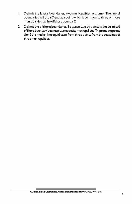
A. USING NORMAL BASELINES
The normal baseline is the baseline described by the coastline of a city or municipality,where such a coastline is relatively smooth and simple and there are no outlying orfringing islands, reefs, rocks, pinnacles, or other abutting features (see Fig. 2).
1. Using fifteen (15) kilometers (on a scale of the chart or map where themunicipal waters will be delineated) as radius and a point on the coastline atlow tide as center of circle, draw arcs of circles from different points on thecoastline of the municipality. Allow these arcs to intersect.
2. Select the outermost arcs that have been drawn. These arcs form the offshorelimit of the municipal waters. Note that not all points along the coastlinecontribute to the delineation of this offshore limit. Usually, only the protrudingpoints of the coastline do count and have the most impact.
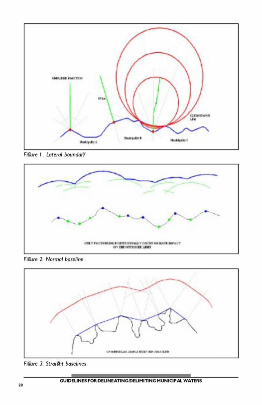
B. USING STRAIGHT BASELINES
A straight baseline is the baseline used in cases where the coastline is deeply indentedor cut into (see Fig. 3).
1. Join protruding points along the coastline by straight lines, the length ofwhich should not exceed thirty (30) kilometers.
2. Draw perpendicular lines passing through the basepoints of each baseline.
3. From the basepoints, measure fifteen (15) kilometers offshore along theperpendicular lines. Connect the offshore points on the perpendiculars ofeach baseline. The line joining these offshore points is parallel to the baseline.
4a. When the exterior angle formed by two consecutive baselines is more than180 degrees, draw an arc of circle, using fifteen (15) kilometers as radiusand the common basepoint of the two baselines as center of circle, from oneperpendicular to the other perpendicular. The offshore limit of the municipalwaters, measured from these two baselines, is the line consisting of the arcand the two parallel lines.
4b. When the exterior angle formed by two consecutive baselines is less than180 degrees, no arc of circle is drawn. The offshore limit of the municipalwaters, measured from these two baselines, is the line consisting of theintersecting two parallel lines.
5. The offshore limit of the entire municipal waters consists of the lines determinedin (4a) and (4b).
16GUIDELINES FOR DELINEATING/DELIMITING MUNICIPAL WATERS
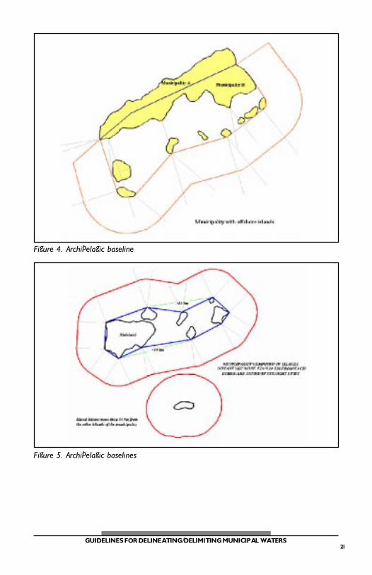
C. USING ARCHIPELAGIC BASELINES
Archipelagic baselines are straight lines joining the outermost points of islands of amunicipality.
1. Municipality with offshore islands
Join the outermost points of the municipality by straight lines, beginningfrom one coastal terminal point (a boundary point on the coast, common totwo municipalities) on the mainland of the municipality; then to the outermostislands; then to the other coastal terminal point of the municipality; providedthat the length of each line shall not exceed thirty (30) kilometers; providedfurther that an isolated island of the municipality, if any, distant more thanthirty (30) kilometers from any of the other islands of the municipality, shallgenerate its own municipal waters. More than one point on an island can beused as basepoint (see Fig. 4).
2. Municipality composed of islands
a. Join the outermost points of the outermost islands by straight lines;provided further that the length of each line shall not exceed thirty (30)kilometers; provided further that an isolated island of the municipality,if any, distant more than thirty (30) kilometers from any of the otherislands of the municipality, shall generate its own municipal waters.More than one point on an island can be used as basepoint (see Fig. 5).
Common to 1 and 2:
b. Draw perpendicular lines passing through the basepoints of eachbaseline.
c. From the basepoints, measure fifteen (15) kilometers offshore alongthe perpendicular lines. Connect the offshore points on theperpendiculars of each baseline. The line joining these offshore pointsis parallel to the baseline.
d1. When the exterior angle formed by two consecutive baselines is morethan 180 degrees, draw an arc of circle, using fifteen (15) kilometers asradius and the common basepoint of the two baselines as center ofcircle, from one perpendicular to the other perpendicular. The offshorelimit of the municipal waters, measured from these two baselines, isthe line consisting of the arc and the two parallel lines.
d2. When the exterior angle formed by two consecutive baselines is lessthan 180 degrees, no arc of circle is drawn. The offshore limit of themunicipal waters, measured from these two baselines, is the lineconsisting of the intersecting two parallel lines.
e. The offshore limit of the entire municipal waters consists of the linesdetermined in (d1) and (d2).
17GUIDELINES FOR DELINEATING/DELIMITING MUNICIPAL WATERS
MANUAL METHOD / PROCEDURE FOR DELIMITING MUNICIPAL WATERS
When the delineation of municipal waters of adjacent or opposite municipalitiesproduce overlapping areas, it is necessary to delimit municipal waters in order toallocate the overlapping areas between the municipalities concerned. Consideringthe archipelagic nature of the country, and the many configurations of the Philippinecoastline, it is very likely that delimitation will be required by most coastalmunicipalities. In these cases, it is necessary to use a simple method of delimiting themunicipal waters in a convenient and cost-effective manner.
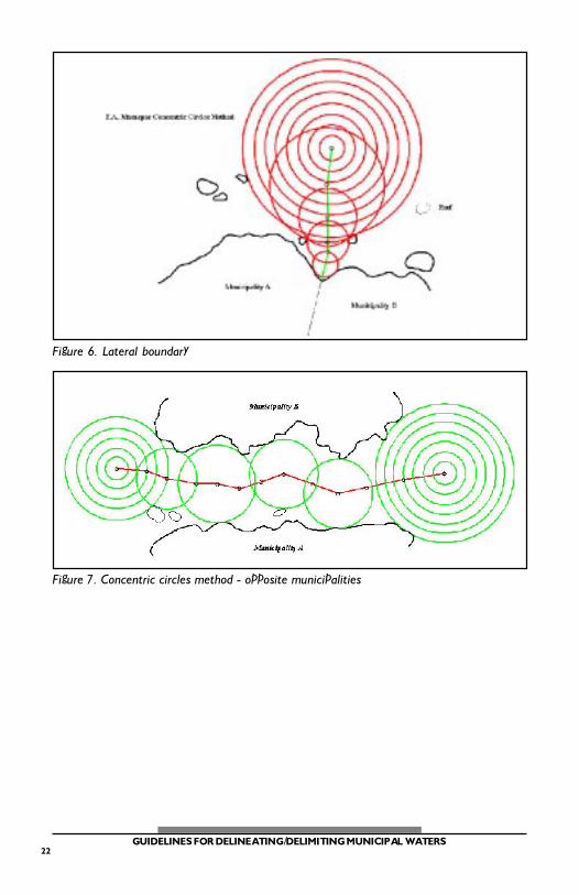
The Enrique A. Macaspac Concentric Circles Method of Determining anEquidistance Line in Boundary Delimitation
The Enrique A. Macaspac Concentric Circles Method of Determining an EquidistanceLine in Boundary Delimitation is based on the theory that the center of a circle isequidistant from any other point on the circumference of that circle. To use thismethod, concentric circles are drawn on a stable, transparent medium such as acetatepaper. For municipal waters, the radius of the largest circle should be made equal tofifteen (15) kilometers on the scale of the nautical chart or topographical map wherethe municipal waters will be delineated and delimited. For convenience, theincremental radius of each circle shall be five (5) millimeters regardless of scale ofchart or map.
The equidistance line is determined by connecting the equidistant points identified bythe center of each circle whose circumference touches at least one point (point oftangency) on both coastlines of the neighboring municipalities, whether adjacent oropposite, whose municipal water boundaries are being determined. The use of thismethod facilitates the delimitation of the waters.
This method also offers the following advantages:
1. Convenience. Since the instruments used are simple and easily available(map or chart, compass, transparent medium like acetate paper, and pen orpencil), there is no need for expensive computer software or experts.
2. Simplicity. The method is very simple, requiring only patience and a sharpeye. Since even an ordinary person can use it, neighboring municipalitiescan easily check each other�s work.
3. Speed. It eliminates the construction lines of other manual methods; thus itis faster.
4. Reasonable accuracy. This method is based on theory. There is no differencein the results using this method (E. A. Macaspac Concentric Circles Method)and the method which uses construction lines, described by A. L. Shalowitzin the Manual on the Technical Aspects of the United Nations Convention onthe Law of the Sea. It also agrees very closely with computer-generatedresults from the software DELMAR (DELimitation of MARitime Boundaries).
18GUIDELINES FOR DELINEATING/DELIMITING MUNICIPAL WATERS
As long as the user is familiar with the use of maps, charts, and scales, theresults produced will be reasonably accurate.
This method has been tested in pilot activities delineating and delimiting the municipalwaters of the coastal municipalities in the provinces of Davao Oriental, Masbate, andBohol.
Procedure for Adjacent Municipalities
The delimitation of lateral boundaries starts from either the common coastal terminalpoints of the land boundaries of the adjacent municipalities, or from the offshore endof the lateral boundary fifteen (15) kilometers from the coastline (see Fig. 6).
1. Move the concentric circles to a point where the circumference of thecircle touches at least one point each on both coastlines of the adjacentmunicipalities. No other points on the coastlines should be within thatcircle. Mark the center of the circle on the chart or map. This point on thechart or map now is equidistant from those two or more points on thecoastlines of the two municipalities.
2. Repeat this step progressively, using the varying radii, until the coastalterminal point (if starting from the offshore end) or the fifteen (15) kilometerlimit (if starting from the coastal terminal point) is reached.
3. Connect the marked points. The line represents the delimited lateralboundary of the municipal waters of the adjacent municipalities.
Procedure for Opposite Municipalities
The delimitation of the offshore boundary starts from one end of the common watersof opposite municipalities, to the other end (see Fig. 7).
1. Move the concentric circles to a point where the circumference of a circletouches at least one point each on both coastlines of the oppositemunicipalities. No other points on the coastlines should be within thatcircle. Mark the center of the circle on the chart or map. This point on thechart or map now is equidistant from those two or more points on thecoastlines of the two municipalities.
2. Repeat this step progressively, using the varying radii, until the other end ofthe common waters is reached.
3. Connect the marked points. The line represents the delimited offshoreboundary of the municipal waters of the opposite municipalities.
Procedure for Three or More Adjacent and Opposite Municipalities
The delimitation of the boundaries among three or more adjacent and oppositemunicipalities having overlapping municipal waters essentially follows the proceduresfor adjacent or opposite municipalities.
19GUIDELINES FOR DELINEATING/DELIMITING MUNICIPAL WATERS
1. Delimit the lateral boundaries, two municipalities at a time. The lateralboundaries will usually end at a point which is common to three or moremunicipalities, at the offshore boundary.
2. Delimit the offshore boundaries. Between two tri-points is the delimitedoffshore boundary between two opposite municipalities. Tri-points are pointsalong the median line equidistant from three points from the coastlines ofthree municipalities.
20GUIDELINES FOR DELINEATING/DELIMITING MUNICIPAL WATERS
Figure 1. Lateral boundary
Figure 2. Normal baseline
Figure 3. Straight baselines
21GUIDELINES FOR DELINEATING/DELIMITING MUNICIPAL WATERS
Figure 4. Archipelagic baseline
Figure 5. Archipelagic baselines
22GUIDELINES FOR DELINEATING/DELIMITING MUNICIPAL WATERS
Figure 6. Lateral boundary
Figure 7. Concentric circles method - opposite municipalities

23GUIDELINES FOR DELINEATING/DELIMITING MUNICIPAL WATERS

24GUIDELINES FOR DELINEATING/DELIMITING MUNICIPAL WATERS