guidelines for architectural investigations in ... · pdf fileguidelines for architectural...
TRANSCRIPT
Guidelines for Architectural Investigations in Pennsylvania
2014
Pennsylvania’s State Historic Preservation Office
Bureau for Historic Preservation
Pennsylvania Historical & Museum Commission
1
TABLE OF CONTENTS 1. INTRODUCTION .......................................................................................................................... 5
2. CONSIDERATIONS FOR RESEARCH METHODOLOGY ...................................................................... 10
Why is Survey Conducted? ............................................................................................................... 10
Compliance Survey ........................................................................................................................... 10
Grant Funded Survey ........................................................................................................................ 10
Planning Survey ................................................................................................................................ 10
Choosing the Level of Survey for your Project ................................................................................ 11
Developing a Research Design ......................................................................................................... 11
Objectives ................................................................................................................................... 12
Identification of the Survey Area ................................................................................................ 12
Background Research ................................................................................................................. 12
Methodology .............................................................................................................................. 13
Expected Results ......................................................................................................................... 13
3. RECONNAISSANCE LEVEL SURVEY ................................................................................................ 14
Methodology .................................................................................................................................... 14
Background Research ................................................................................................................. 14
Resources.................................................................................................................................... 15
Developing an Historic Overview ............................................................................................... 15
Field Work and Documentation ................................................................................................. 16
Photographs ............................................................................................................................... 16
Existing Survey Data ................................................................................................................... 16
Mapping ...................................................................................................................................... 17
Reporting .................................................................................................................................... 17
4. INTENSIVE LEVEL SURVEY ............................................................................................................ 18
Methodology .............................................................................................................................. 18
Research ..................................................................................................................................... 19
Appropriate Level of Research/Information Sources ................................................................. 19
Developing a Historic Context .................................................................................................... 20
Field Work and Documentation ................................................................................................. 21
Mapping ...................................................................................................................................... 21
Evaluation ................................................................................................................................... 21
5. GUIDELINES FOR COMPLETING SURVEY FORMS ........................................................................... 27
Stand Alone Forms ........................................................................................................................... 27
Standard Historic Resource Survey Form (HRSF) ....................................................................... 27
Abbreviated HRSF ....................................................................................................................... 27
Bridge Survey Form .................................................................................................................... 28
2
Industrial Complex Form ............................................................................................................ 28
Supplemental Forms......................................................................................................................... 29
Agricultural Survey Form ............................................................................................................ 29
Building Complex Form............................................................................................................... 29
Historic Cemetery and Marker Survey Form .............................................................................. 29
Historic District Inventory Worksheet ........................................................................................ 29
Portable Application ......................................................................................................................... 30
Required Attachments to all forms .................................................................................................. 30
Current Photographs .................................................................................................................. 30
Plans/Maps ................................................................................................................................. 32
6. COMPLIANCE INVESTIGATIONS .................................................................................................... 35
The Compliance Process ................................................................................................................... 35
Project Initiation ............................................................................................................................... 36
Attachments to the Project Review Form must include: ........................................................... 36
Use of Consultants ...................................................................................................................... 38
Identification of Historic Properties ................................................................................................ 39
Choosing the Level of Survey Documentation ........................................................................... 39
Developing a Research Design .................................................................................................... 39
Background Research ................................................................................................................. 41
Reconnaissance Survey............................................................................................................... 41
Intensive Level Survey ................................................................................................................ 41
Field Survey................................................................................................................................. 42
Assessment of Eligibility ................................................................................................................... 42
Assessment of Effect ........................................................................................................................ 43
Introduction ................................................................................................................................ 43
Project Description ..................................................................................................................... 43
Results of Identification of Historic Properties........................................................................... 43
Finding of Effect .......................................................................................................................... 43
Measures Undertaken to Avoid or Minimize Effects to Historic Properties .................................. 44
Examples of creative & meaningful mitigation: ......................................................................... 45
Resolution of Adverse Effects .......................................................................................................... 45
Public Involvement/Section 106 Consultation ................................................................................ 46
Treatment of Historic Properties ..................................................................................................... 47
7. REPORT STANDARDS ................................................................................................................... 48
Report Format .................................................................................................................................. 48
Title Page .................................................................................................................................... 48
Abstract or Management Summary ........................................................................................... 48
3

Table of Contents ....................................................................................................................... 49
List of Figures, Plates and/or Tables ........................................................................................... 49
Introduction ................................................................................................................................ 49
Methodology & Expected Results .............................................................................................. 49
Background Research ................................................................................................................. 49
Context & Property Types .......................................................................................................... 50
Field Results ................................................................................................................................ 50
National Register Eligibility Recommendation ........................................................................... 50
Assessments of Possible Project Effects on Resources (for ER projects) ................................... 50
Public and Consulting Parties (for ER projects) .......................................................................... 50
Sources/bibliography .................................................................................................................. 50
Appendices ................................................................................................................................. 50
Required Work Products Provided to BHP ...................................................................................... 51
Specific Requirements ...................................................................................................................... 51
Historic Resource Survey Forms & Inventory ............................................................................. 51
Maps ........................................................................................................................................... 51
Photographs ...................................................................................................................................... 52
8: DATA MANAGEMENT ................................................................................................................... 53
Mapping & Location Requirements ................................................................................................. 53
Location Map vs Site Map .......................................................................................................... 53
How to Map a Resource ............................................................................................................. 53
Boundary Lines ........................................................................................................................... 55
Submitting Digital Map Locations ............................................................................................... 55
Updating Data ............................................................................................................................. 55
Portable Data Entry .......................................................................................................................... 56
CRGIS Data Sharing Protocols .......................................................................................................... 57
Project Specific Data Requests ................................................................................................... 57
Long-Term Data Sharing Agreements ........................................................................................ 57
APPENDIX ........................................................................................................................................ 59
Historic Functions List ....................................................................................................................... 60
Criteria for Determining Appropriate Mitigation .............................................................................. 63
Checklist for Planning and Conducting Survey .................................................................................. 64
4

1. INTRODUCTION What is the purpose of this document? Guidelines for Architectural Investigations in Pennsylvania is meant to serve as a reference for conducting survey and research of architectural and historical properties in the Commonwealth. Previously, researchers had to refer to a range of resources including those published by the National Park Service and the Pennsylvania Historical and Museum Commission-Bureau for Historic Preservation (PHMC-BHP) These resources included the Secretary of the Interior’s Standards and Guidelines which provide broad standards and guidelines for the implementation of historic preservation activities, including survey. This document is meant to serve as a comprehensive resource and to provide detailed explanation of the survey process and expectations in Pennsylvania. These guidelines are designed to create consistent data collection which will improve the quality of research and documentation, thereby expediting project reviews. This document will provide guidelines to complete documentation for a variety of survey projects. Local governments may use the guidelines to aid in local survey efforts. Agencies may rely on the guidelines to ensure all submissions provide sufficient information for consultation with our office. For guidance on listing a property in the National Register of Historic Places, see our website or the National Park Service’s website. Consultation with PHMC-BHP staff is encouraged when assistance is needed or questions arise that are not covered under these guidelines. What is a historic resource? The National Register defines a historic property as a district, site, building, structure, or object significant in American history, architecture, engineering, archaeology or culture. For the purposes of this document, a historic resource is an above-ground resource that has something important to tell about our past and retains enough historic qualities to tell the story well. Historic resources may be of value to the Nation, State or to a local community. What is a historic resource survey? A survey is a process of gathering and recording information about a historic property, within a specific geographical area or theme, and documenting the resource to an established standard. Survey involves organizing field data, background research, and interviews; and producing inventories and evaluations. Survey is fundamental to historic preservation because it acknowledges that resources add value to society. Survey allows organizations to easily prioritize which resources are worthy of preservation. Although referred to as architectural, a survey should look beyond buildings to include all aspects of the environment that combine to form our historic landscape, including bridges, canals, outbuildings, cemeteries, parks, gardens, landscape features, etc. Survey can be conducted on a variety of scales, depending on the needs of the survey, as discussed in detail in this document.
5
Why conduct historic resource surveys? Survey of architectural resources is important in Pennsylvania because it helps us identify significant buildings, structures, and districts on which to focus our limited preservation resources. Conducting surveys and creating an inventory of resources are the first steps toward preservation of resources most important to our heritage. Information obtained from surveys is used to provide insight into a community’s past, as well as to make decisions during community and project planning. Survey data is also used to increase understanding and public awareness of a community’s resources. In addition, it is used to create a plan for the preservation of a community’s significant resources. Who conducts historic resource surveys? As mandated by the National Historic Preservation Act of 1966 (NHPA), surveys are carried out under the direction of the State Historic Preservation Office (SHPO), as well as other preservation professionals and interested citizens. The Pennsylvania SHPO is housed in the Pennsylvania Historical and Museum Commission (PHMC) at the Bureau for Historic Preservation (BHP). The PHMC-BHP maintains a statewide survey of historic resources in accordance with the Pennsylvania History Code. What are the different uses for historic resource inventories at the State and Federal level? The Pennsylvania History Code directs the PHMC to compile, maintain, revise and publish an inventory of significant historic resources in the Commonwealth, known as the Pennsylvania Register of Historic Places. The policy and practice of the PHMC is that properties listed in or eligible for the National Register of Historic Places shall constitute the Pennsylvania Register of Historic Places. The National Register of Historic Places (National Register) is a federal tool for preservation, planning, recognition, and public education. Properties are typically listed in the National Register through nominations made to the SHPO. Applications to the National Register are reviewed against established criteria, as discussed in detail in this document. The National Register is the Nation’s list of historic properties worthy of preservation and consideration under Section 106 of the NHPA. If listed in the National Register, a property is eligible to apply for certain grants and tax incentives, when available. The fundamental purpose of historic resource inventories is to assist in planning so historic resources important to a community can be considered in future development plans. A historic resource inventory can be helpful to identify candidates for National Register eligibility, and these inventories are also useful for administering local preservation programs. Do local municipalities use the same type of historic resource inventories? Local historic preservation programs and ordinances are developed with historic resource inventories to manage locally important properties. Often one of the first steps in a local planning process is the completion of an inventory (please see the BHP’s Guidance for Historic Preservation Planning). A comprehensive historic preservation planning process will also identify a number of goals. Some specific strategies to achieve local preservation goals result in the protection of historic resources.
6
In Pennsylvania, local governments have a degree of flexibility in their approach to the protection of their historic resources. Under authority of the Historic District Act, commonly known as Act 167 of 1961, a municipality may adopt a ‘special purpose’ historic district ordinance. In other words, a municipality with no zoning regulations may still enact a special purpose ordinance to create a local historic district. The Historic District Act authorizes all Pennsylvania municipalities, with the exception of first and second class cities, to create and define by ordinance one or more historic districts. However, a municipal ordinance created under the Historic District Act cannot be implemented until the Pennsylvania Historical and Museum Commission certifies the historical significance of the district(s). Steps to establish a local historic district under the Historic District Act can be found on the Community Preservation web page. Another option for protecting a municipality’s historic resources is the Pennsylvania Municipalities Planning Code (MPC), Article VI. This provides local governing bodies with zoning powers for, among other purposes under § 604(1), the “preservation of the natural, scenic, and historic values…” What is the role of the PHMC-BHP in survey? Various divisions of the PHMC-BHP work with local governments, historical societies, consultants, federal and state agencies, and private organizations to assemble, maintain, and update the survey record. National Register staff coordinates determinations of property eligibility, leading to recommendation for listing in the National Register. GIS staff maintains the state’s resource files, database and the online GIS mapping application, Cultural Resources Geographic Information System (CRGIS), accessible to professionals and the public. For large-scale surveys, staff provides guidance for electronic data collection. Grants staff and Community Preservation Coordinators work with individuals and groups to increase the agency’s inventory of historic resources through grant funded survey. The Project Review staff collect the largest amount of survey data through the compliance process which requires the identification of resources listed in or eligible for listing in the National Register of Historic Places and assessment of project effects. Who is qualified to conduct survey? The PHMC-BHP standards to conduct or supervise architectural survey conform to the Secretary of the Interior’s Standards for Archaeology and Historic Preservation. These standards, defined by the National Park service, outline the minimum education and experience necessary to conduct identification, evaluation, registration, and treatment activities. Professional expertise must be relevant to the work being conducted; a historian, historic preservationist, or architectural historian is qualified to conduct a survey and perform documentation tasks for architectural investigations. For more specific qualifications, please consult the NPS standards. What is the history of historic resource survey in Pennsylvania? PHMC-BHP awarded its first grants for historic resource surveys in 1970 long before the days of standardized survey forms and data collection. The results varied by county and community sponsor: some projects documented nearly every building over 50 years old, and others concentrated on early stone buildings. Architectural significance and integrity were the most common criteria used during recordation. Most forms had little, if any, information on the property’s history or past owners. In an effort to better align this survey information with the National Register evaluation process, the BHP required that surveyors only fill out standardized forms for the more significant buildings and complexes in a municipality with a
7

detailed description and narrative. This new process expected consultants to provide the appropriate level of information to evaluate the identified resources. Additionally, the BHP developed new statewide contexts for certain types of resources, including schools, farms, railroads, and postwar suburbs, as a tool to increase consistency. PHMC-BHP now requires all grant funded survey to be collected consistently so data could be transferred directly into CRGIS for the benefit of all. What were considered acceptable standards in county-wide surveys conducted in the 1980s are no longer considered appropriate methodology by today’s standards due to the evolution of technology, mapping, and data collection. What are the different levels of survey? The Secretary of the Interior’s Standards and Guidelines distinguish between two levels of survey:
1) Identification/Reconnaissance: This type of survey is most useful for generally characterizing resources and determining the basis for how to organize more detailed survey. A term commonly associated with this type of survey is “windshield survey,” which involves driving within a geographic area to determine the architectural styles, periods and modes of construction that are present. A study of current and historic aerial photographs and other research information leads to an understanding of the area’s layout and development over time. The purpose of survey is never solely to identify candidates for National Register eligibility. It is critical to remember that for planning purposes, resources that are important to a community should be considered for recordation regardless of National Register eligibility.
The Pennsylvania Municipalities Planning Code requires that communities develop comprehensive plans that include a historic preservation component to consider locally important historic resources. Fulfilling this requirement requires some form of identification of resources, most commonly a survey.
2) Evaluation/Intensive: As implied, this involves a close and careful look at the resources included within the examined area. This survey type is designed to precisely and completely identify all resources within a given area. It involves detailed background research and a thorough inspection and documentation of all historic resources in the survey area. Evaluation survey provides sufficient information to prepare a comprehensive historic inventory and evaluate the resources’ eligibility for listing in the National Register.
Reconnaissance level surveys are often conducted before intensive level surveys and are used to plan the methodology for intensive level survey. This enables the intensive level survey to focus efforts on concentrated areas of historic resources that warrant further documentation and consideration. While guidance is provided in this document, any questions regarding the appropriate type of survey for a project should be directed to PHMC-BHP staff.
8
How do I determine if a property was previously surveyed? Since 2005, PHMC-BHP has maintained an online resource file database and mapping application that displays available agency files, known as the Cultural Resources Geographic Information System (CRGIS). All historic resource data is available to the public via this resource. Not all previously recorded resources are mapped, but all are included and searchable in the database. Most historic surveys are not mapped, due to their large or scattered survey areas. However, survey information is included in the searchable database. CRGIS is a tool to access some of the data available in the PHMC-BHP files without making a trip to Harrisburg, where access to the paper records is free and open to the public by appointment. CRGIS is also the tool for determining the files to request during a visit to our research room. Click here to visit CRGIS - the online database of resources What is not covered by this document? Unfortunately, this document does not address other types of planning documents such as historic structure reports and preservation plans. How should I coordinate architectural and archaeological surveys? Architectural surveys must identify the existence of potential archaeological resources. This could be notation of above ground remnants or ruins or the former location of above ground resources that are no longer extant based on an examination of historic mapping or previous documentation in the field. However, the documentation of archaeological resources should be provided in a separate submission from the architectural survey in accordance with the most current version of the Guidelines for Archaeological Investigation in Pennsylvania.
9

2. CONSIDERATIONS FOR RESEARCH METHODOLOGY Survey investigations enable communities, organizations, and agencies to inventory the historic resources of a specific area. Not every building, site or structure that is old is historic, but a survey can determine what is important to our history and culture at a local, state, or national level. A resource that is important to a community might never appear on a list of nationally significant places but can still be historic as part of the survey effort and worthy of recordation. Why is Survey Conducted? Architectural survey in Pennsylvania is generated to meet three goals or purposes: compliance, grant funding or planning needs, as outlined in more detail below. Compliance Survey
Compliance survey stems from federal and state laws that recognize that historic preservation is in the public interest and worthy of government consideration. Under relevant legislation, federal and state agencies must consider the effect of their action on significant cultural resources. A significant resource is defined as one which is listed or eligible for listing in the National Register of Historic Places. The PHMC-BHP is required to maintain an environmental review and compliance program to ensure the consideration of historic properties under Section 106 and the State History Code. Compliance staff assist federal and state agencies in determining National Register eligibility and assessing the effect of their actions on historic properties, often called the Section 106 review process. Grant Funded Survey In accordance with Section 110 of the NHPA, the PHMC-BHP is eligible for Historic Preservation Fund (HPF) grants for survey and documentation. The PHMC-BHP devised the Certified Local Government Grant program as the channel through which federal grant money is passed on to local governments and other entities. The funding is available for a wide variety of programs including but not limited to the development of preservation plans; architectural and archaeological inventories; and National Register nominations. Additionally, the PHMC-BHP’s Keystone Historic Preservation Grant program funds similar activities that encourage the preservation of National Register related resources. The Keystone program is open to a larger applicant pool, reaching nonprofit organizations and local governments. Planning Survey Pennsylvania encourages consideration of historic resources in local and regional planning efforts through the Municipalities Planning Code, revised in 2000. Units of government have an opportunity to identify historic and cultural resources and utilize that information to manage preservation of significant resources. These surveys not only identify historic resources but also consider associated issues, problems and opportunities, providing for development of goals and strategies for their protection. This process allows
10

for public input to develop the attributes under which resources can be considered significant, many of which are not linked to National Register criteria. PHMC-BHP developed guidance for Historic Preservation Planning that provides a framework for creating a comprehensive historic preservation plan consistent with those established for other sections within the comprehensive plan. Choosing the Level of Survey for your Project There are many variables in a historic resource survey which are largely dependent on the purpose and intended outcomes of the survey. The survey methodology and level of effort are responsive to project needs and preservation goals, so it is important to quantify what information is required at the end of the project and choose the appropriate level of survey while planning the research design. Depending on the needs of the survey sponsor, an identification survey may precede an evaluation survey, or the two levels can be compressed into a single survey effort.
1. Identification/Reconnaissance Survey is the basic level of survey that results in the characterization of an area’s general development patterns and the nature of its built resources. This type of survey is most useful for generally characterizing resources in the survey area and determining the basis for organizing a more detailed survey. It collects enough physical information about the age, materials, style, condition, and location of a property so that it is easily identified. Identification surveys do not generally collect information related to the specific history or importance of a property but rather address the development and history of the overall survey area. Identification surveys may include a limited identification of above ground features that may be treated as (archaeological) resources.
2. Evaluation/ Intensive Survey is designed to identify precisely and completely all resources within a given area. Evaluation survey provides sufficient information, according to pre-established criteria, about a property in order for it to be evaluated for National Register significance. Evaluation surveys may outline criteria for National Register significance or may use registration requirements established by historic contexts. Background research relevant to evaluation survey includes information that specifically explains the relationship of a property to important themes and property types of an area and explains how the property meets established criteria.
Developing a Research Design
Before beginning any survey activity, it is imperative that a research design is developed to capture the goals and expected outcomes of the project and to define results, or deliverables, of the survey. The objectives, methodology, survey area, and expected deliverables are specified in the research design. This work defines goals for developing historic contexts and the scale of the survey. Research design clarifies the proposed use of the collected data and can bolster public participation in the project.
11

Objectives
The first step in developing a research design is to clearly state the goal of the project and how the survey data will be used. Is the purpose of the project to identify surviving agricultural or commercial properties within a borough; extant industrial resources related to the operation of an early nineteenth century canal; or educational buildings that might reflect the Long-Progressive period as defined in the Historic Educational Resources of Pennsylvania? The objective should relate to a historic context or a property type and include an assessment of previous research. Survey objectives might be to characterize properties in a planning area, to assess the existence of a historic district, to identify properties associated with a particular context, or to determine which properties in an established geographic area may be significant. The survey objectives depend on why the survey is being conducted; state the objectives and reason for the survey clearly (compliance vs. planning purposes). They should include the intensity or level of survey effort for the project and/or how it will be structured. Additional assistance in identifying appropriate goals and objectives may be found in National Register Bulletin Guidelines for Local Surveys: a Basis for Preservation Planning. The PA SHPO staff is available to assist with research design development. Preservation Services staff can ensure that the survey project is compliant with the Bureau for Historic Preservation (BHP) CRGIS database, BHP survey standards, and PHMC’s Building Better Communities: The Preservation of Place in Pennsylvania, our statewide historic preservation plan for 2012-2017. Identification of the Survey Area
Usually, a survey area is defined by municipal boundaries or areas where there is the potential for project effects. Survey areas may also focus on properties that reflect specific historic contexts or endangered property types. The fundamental purpose of a survey is to assist in planning, so that historic resources important to an area can be provided for in future development. The Pennsylvania Municipalities Planning Code requires that communities develop comprehensive plans that include a historic preservation component to consider locally important historic resources. The purpose of survey is never solely to identify candidates for National Register eligibility. It is critical to remember that for planning purposes, resources that are important to a community should be considered for recordation regardless of National Register eligibility.
Background Research
This effort involves determining the nature and extent of previously recorded resources within a survey area. Information on the history and development of a community and anticipated property types is useful in the planning and development of the survey. If background research indicates that significant resources may be concentrated in a portion of the survey area, then those areas are targeted for survey first and may receive priority over areas where there are fewer resources.
12

Methodology
A successful survey includes a detailed outline discussing each of the following: • data collection • personnel • survey objectives • archival research • fieldwork techniques • level of effort
Expected Results
Finally, present an understanding of the kind, number, location, character and condition of historic properties that are anticipated during the course of the survey.
13

3. RECONNAISSANCE LEVEL SURVEY A reconnaissance survey, also known as Identification or Phase I survey, is a cursory examination of historic resources in a specific geographic area or associated with a specific theme. It involves locating, describing and photographing resources of a pre-determined age (depending upon the purpose of your survey) within a survey area and providing an overview of the historical development of the survey area. Reconnaissance surveys include a minimal amount of background research to establish the historical development and identify trends within an area. Only exterior documentation of a resource is required in reconnaissance level survey. The survey must also identify small scale features and landscape elements that are part of the setting for a property. Although reconnaissance level survey data is not usually sufficient to evaluate individual eligibility of resources for listing in the National Register, it does record resources at a minimal level and may serve as a useful planning tool. This level of survey is especially useful for determining the distribution of historic architectural resources in an area. It often provides a basis for more intensive surveys in future studies. Reconnaissance level surveys are appropriate for large scale compliance projects. Methodology Background Research Before any field work begins, research the survey area or resource type to establish what is already known. This is especially useful for large-scale survey projects, informing the development of survey strategies before a more time consuming and costly field survey. This includes examining histories and maps to indicate the anticipated distribution of resources on the landscape and changes over time. Extensive background research on individual properties is not needed to complete the reconnaissance survey but is required during intensive level survey. Preliminary Research Sources:
1. BHP’s Cultural Resources Geographic Information System (CRGIS) 2. BHP’s paper survey files (contact BHP at 717-783-0395 to schedule an appointment to review these
files) 3. Historic maps/atlases/aerial photos (see table below) 4. County histories 5. County or local historical societies 6. County or municipal planning offices and archives 7. And any other sources that can provide a good general overview of a defined geographical area
The PHMC-BHP file room is the repository for many of BHP’s paper survey files, including reports of previous surveys and historic property files. At a minimum, researchers must consult the unpublished reports and historic resource files to determine what is known in the project area and if the previous survey information requires an update. Files of the PHMC-BHP also help guide the field survey and save time by indicating the location of documented National Register resources and other previously identified resources.
14
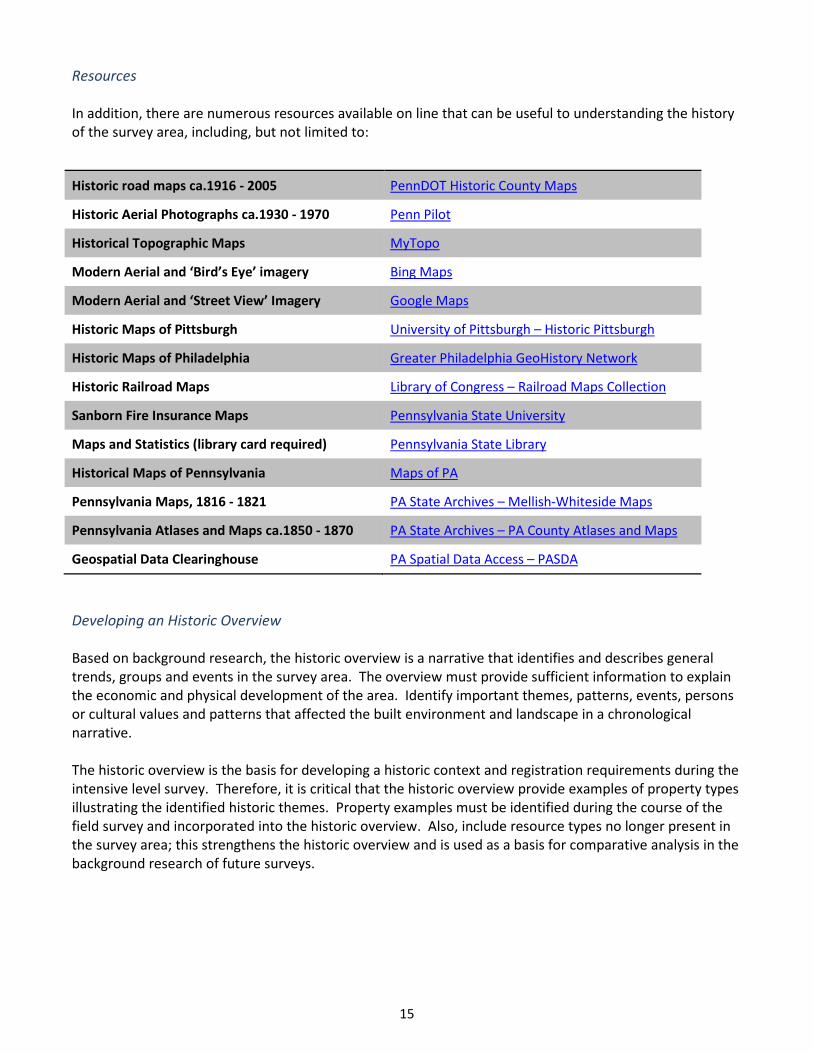
Resources In addition, there are numerous resources available on line that can be useful to understanding the history of the survey area, including, but not limited to:
Historic road maps ca.1916 - 2005 PennDOT Historic County Maps
Historic Aerial Photographs ca.1930 - 1970 Penn Pilot
Historical Topographic Maps MyTopo
Modern Aerial and ‘Bird’s Eye’ imagery Bing Maps
Modern Aerial and ‘Street View’ Imagery Google Maps
Historic Maps of Pittsburgh University of Pittsburgh – Historic Pittsburgh
Historic Maps of Philadelphia Greater Philadelphia GeoHistory Network
Historic Railroad Maps Library of Congress – Railroad Maps Collection
Sanborn Fire Insurance Maps Pennsylvania State University
Maps and Statistics (library card required) Pennsylvania State Library
Historical Maps of Pennsylvania Maps of PA
Pennsylvania Maps, 1816 - 1821 PA State Archives – Mellish-Whiteside Maps
Pennsylvania Atlases and Maps ca.1850 - 1870 PA State Archives – PA County Atlases and Maps
Geospatial Data Clearinghouse PA Spatial Data Access – PASDA
Developing an Historic Overview Based on background research, the historic overview is a narrative that identifies and describes general trends, groups and events in the survey area. The overview must provide sufficient information to explain the economic and physical development of the area. Identify important themes, patterns, events, persons or cultural values and patterns that affected the built environment and landscape in a chronological narrative. The historic overview is the basis for developing a historic context and registration requirements during the intensive level survey. Therefore, it is critical that the historic overview provide examples of property types illustrating the identified historic themes. Property examples must be identified during the course of the field survey and incorporated into the historic overview. Also, include resource types no longer present in the survey area; this strengthens the historic overview and is used as a basis for comparative analysis in the background research of future surveys.
15
Field Work and Documentation Field work is an opportunity to confirm the results of the background research and historic overview efforts. Locating previously identified or evaluated resources is useful for determining the property’s appearance at the time of documentation, as well as the quality of the prior documentation. As detailed research is not conducted at the reconnaissance level, dates of construction can be based on benchmark references, such as historic maps at specific years (Table 1). Surveyors should be consistent in their use of benchmark references in order both to relate the resources to each other and to the history of the community and to ensure that their evaluations are accurate. Please use the Abbreviated Historic Resource Survey Form for field work at the reconnaissance level. The form includes the minimum information accepted to document a resource for inclusion in CRGIS. The form includes locational information, mapping, brief descriptive information, and sufficient photographic documentation to accurately judge physical condition and integrity. The Abbreviated Form provides sufficient information to determine if the property warrants further research and documentation at the intensive level. Guidance for completing the Abbreviated Form is included in Section 5. Photographs Photographic documentation includes not only photographs of the primary elevation but also photographs of a side, rear wings, additions, outbuildings, and landscapes. For each property within the reconnaissance level survey area, include at least two pictures; one of the primary elevation and one side angle, as provided on the Abbreviated Historic Resource Survey Form. Additional photographs can be provided on attached sheets. The photographs must be clear enough to convey the character, setting and significance of the subject. Photographs may be prepared in digital format as long as they are at or near the visual clarity of traditionally printed 35mm photographs and printed using archivally stable inks and papers. All digital files should meet the National Register Photo Policy Factsheet standards. Photographs should be a minimum of 3.5” x 5” and a maximum of 5” x 7”in size. Existing Survey Data It is possible that completed survey forms already exist for properties in the study area. If the resource was previously surveyed, a unique six-digit identification number, or BHP Keynumber, was assigned. This is found by searching CRGIS for the property. Include this BHP Keynumber on the survey form and attachment pages for each resource to prevent duplicating files. If a form was prepared within the last five years and contains sufficient information to convey the current appearance of the property, the lack of changes since the previous survey should be noted in the report; no additional documentation is required. However, if there is substantive new information on the history of the resource, affecting significance, a new form should be completed even if there are no significant changes affecting integrity.
16
Mapping The survey must include one comprehensive map, showing the location of each surveyed resource. The BHP requests that the base map used for the comprehensive map be current. Unless the survey is completely within a town where street references are important, the base map should be a USGS 7.5’ topographic map. For compliance surveys, you must graphically delineate the Area of Potential Effect on a USGS topographic map. The report should include current and historic maps depicting locations of all identified resources, with Keynumbers (if known). All maps must include a graphic scale. The map’s scale may not be enlarged to a resolution that pixilates the image to a point when geographic landmarks that help locate the property, such as the nearest town, are not depicted. A north arrow, delineation of the project area, legend, map title, bar scale and year of publication must be included on all maps including historic maps. No map may be reproduced on paper which is larger than 11” x 17”. Reporting After the field survey has been completed, a reconnaissance survey report is prepared. The report organizes the information collected during the survey, including the forms, and presents this information along with the surveyor’s recommendations for the intensive level survey. The report should address the types of properties present in the survey area, including the specific properties that were identified, and categorize the information collected (by property type), explaining how the properties reflect the history of the area. The report should also summarize the trends or patterns in the architecture and built environment, including an assessment of the integrity and condition of extant resources. The report should note those areas examined that did not contain properties. Overall, enough information on the appearance, integrity, and significance for each property should be provided in order to make preliminary recommendations of eligibility or present the need for further research. For compliance projects, it is necessary to identify potential districts or lack thereof and properties that should be further documented for potential National Register eligibility. A resource only needs to be potentially eligible at the local, state, or national level under the National Register Criteria to be recommended for inclusion in an intensive level survey. Initial recommendations of eligibility should be made and the report should explain how the National Register Criteria were applied to make the recommendations. The report should conclude by outlining further research that is needed and recommendations for the intensive survey. For compliance survey reports for historic districts or complexes that contain multiple buildings, an inventory sheet must be included to accurately account for all historic resources present. The Historic District Inventory Form is available for recording historic district information and includes the tax parcel number, address, name of property, date, style, material, type of resource (building, structure, object, or site), historic function, and recommended contributing/non-contributing status. Each resource within the complex must be included even if it is a modern building. Other information about the resource is optional but may be useful depending on the research model necessary for the project.
17

4. INTENSIVE LEVEL SURVEY This type of survey builds on the reconnaissance level survey that either 1) identified all of the resources of a certain age, usually over 50 years old, within a given area (e.g. township, county, APE, etc.) or 2) identified resources associated with a specific theme (e.g. education, agriculture, etc.) in a given area. As its name implies, intensive level survey requires more exhaustive research and in-depth documentation of a property. An intensive level survey provides sufficient information to evaluate resources for eligibility for the National Register of Historic Places or for eligibility under other pre-established criteria. Although the following discussion references eligibility for the National Register, it should be stressed that the same process would be followed if any other pre-established criteria are being used in the evaluation. Methodology
After conducting a reconnaissance level survey, the surveyor should have a strong understanding of historic themes represented by resources within the surveyed area. Historic themes are essentially the same as National Register areas of significance (e.g. commerce, industry, etc.) and are reflected by resource or property types (e.g. orphanages, prisons, etc.). The historic context focuses on a specific geographic area. It requires background research on the historic themes that characterize the survey area and resources associated with those themes, based on previous survey data or background research. The historic context identifies significant historic themes that characterize the survey area. It explains why each theme is significant and what property types are associated with each theme. A context makes clear the associations and character-defining features, as well as the most critical aspects of integrity that must be present, for a representative property to be significant for the National Register of Historic Places. In cases where there is no established historic context, the survey will develop a historic context to evaluate identified resources. Based on historic context(s) and reconnaissance level survey, the surveyor will identify resources appearing to have potential for National Register eligibility. The surveyor will then conduct additional property-specific research and documentation such as additional photographs, including interiors if possible, to evaluate the property’s significance under a historic context and whether it retains integrity. With this information, the surveyor will draft a report following the outline below. The report must discuss why certain properties were chosen for intensive level survey while others were not. It must also provide each surveyed property with a recommendation of eligibility for the National Register. The report, along with the HRSFs generated, must be submitted to the Bureau for Historic Preservation for its opinion on the eligibility of the resources.
18
Research
As already mentioned, there are two types of required research for intensive level survey: 1) research to establish the historic context(s) under which resources are evaluated and 2) research to establish whether individual properties are significant under the context. Research to establish historic contexts must focus on a logical geographic area (e.g. a city or a borough or a township or a county); however, for compliance survey, fieldwork should be confined to the area of potential effect (APE). The APE is often an arbitrary designation and should not be the basis for a context. Appropriate Level of Research/Information Sources
Establishing the context to evaluate surveyed properties requires research sufficient to identify property type(s), their character-defining features and specific associations a property must demonstrate to be eligible for listing in the National Register. Sources of information to consult in developing an historic context include:
1. BHP’s Cultural Resources Geographic Information System (CRGIS) 2. BHP’s file room (contact BHP to schedule an appointment to review these files) 3. County histories 4. County or local historical societies 5. Historic maps/atlases/aerial photos 6. Historic directories 7. Historic census data (e.g. censuses of manufactures, agricultural censuses) 8. Centennial books 9. County or municipal planning offices and archives 10. Other sources that can provide a good general overview of a defined geographical area
Sources of information to consult in providing sufficient background for the evaluation of properties follow. Research must be sufficient to demonstrate the property is significant under a particular context. Sources of information to consult for properties include:
1. Deed records 2. County histories 3. Historic maps/atlases/aerial photos 4. Local historical societies 5. Oral history interviews (if applicable) 6. Property-specific census data 7. Historic postcards/illustrations 8. Historic photographs 9. Historic newspapers 10. And any other sources that can provide specific information about a property
19

Developing a Historic Context
According to the National Register bulletin How to Complete the National Register Multiple Property Documentation Form (p. 6), “a historic context is a body of information about related properties organized by theme, place, and time.” An historic context for the area surveyed is not simply a history; it identifies and explains the significant historic themes—these themes can correspond to areas of significance from pages 40-41 of the National Register bulletin 16A: How to Complete the National Register Registration Form or to different types of properties—that characterize the area surveyed. It explains the importance of these themes and their characteristics through time. After developing the historic context and identifying and discussing the significant historic themes, the historic context must present the property types associated with each theme. Property types provide the link between a historic context and an individual property. They serve as a baseline that enables the surveyor to assess National Register eligibility. After establishing property types for a historic context, the survey will compare the surveyed individual property with the property type. For additional information refer to pages 14-16 of the National Register bulletin: How to Complete the National Register Multiple Property Documentation Form. For example, if industry is a significant theme within the surveyed area, examples of property types might include resources associated with manufacturing or extraction or resource processing. Property types do not need to be complicated. For instance, the Multiple Property Documentation form for agriculture in Pennsylvania includes just three property types: the farmstead (farmhouse and outbuildings), the farm (farmstead plus associated acreage), and the historic agricultural district (a group of farms). There is really no limit to potential property types; however, they must be logical and related to the resources that exist within the given area. After the property types are established, the context must explain what each property type must possess in order to be significant for the National Register; this explanation is what BHP refers to as the registration requirements. A resource is not eligible simply because it is a representative of a property type; it must be a significant example of the property type. In some cases, BHP has developed researcher’s guides for different themes. These guides should be referenced when preparing a historic context. While these researcher’s guides do not provide as much detail as a context or Multiple Property Documentation Form, they provide questions to guide research. In some cases, a specific historic theme has been covered by a National Register Multiple Property Documentation Form, either for the entire state or for the region being surveyed. Over fifty contexts approved by the National Park Service are available on the BHP Historic Context webpage. In these cases, the intensive level survey does not have to address that specific theme, but must reference the appropriate existing document. When evaluating specific properties using one of these documents, the surveyor needs to explain how the property meets or does not meet the registration requirements outlined in Section F: Associated Property Types of the MPDF. In addition, the surveyor will demonstrate how the property retains integrity in light of the standards laid out in the MPDF.
Visit our website for National Park Service approved Multiple Property Documentation Forms and guidance
on developing historic contexts.
20
Field Work and Documentation
After the historic context, property types, registration requirements, and standards for integrity are developed and candidates for intensive level survey are chosen, additional fieldwork and research on the individual properties chosen for intensive level documentation is conducted. Research undertaken should be sufficient to complete a Pennsylvania HRSF (see Section 5). For individual properties, documentation must include exterior photos showing each resource. Photos must include all sides of the principal resource, multiple views of the setting, and every additional resource on the property. If possible, interior photos of the major buildings on the property should be included; they should give an idea of the overall interior layout and provide detail views of any important interior spaces and features. Photos must be keyed to a site plan and floor plans. Field work should identify and date any changes that have been made to the resource(s) on the property and these dates must be corroborated with background research. The documentation must include detailed information on the history and significance of the property. For historic districts or complexes (e.g. farms, industrial resources, etc.), documentation must include photos that show overviews, streetscapes and important resources in the district. The photos must be keyed to a site plan that identifies and dates buildings and features. The documentation should discuss, in general, changes that have been made to individual resources (e.g. cladding, window replacements, etc.), as well as changes that have been made to the district as a whole (e.g. demolitions, new construction, etc.). The documentation should include detailed information on the developmental history and significance of the district. Mapping
In addition to keying photos to a site plan, as explained in the previous paragraph, each individual property must be mapped. For mandatory mapping standards, please see the Reconnaissance Level Survey Mapping section. For historic districts, mapping should clearly illustrate recommended district boundaries as well as contributing and noncontributing resources. Evaluation
National Register Criteria The National Register Criteria are one way of evaluating properties; local surveys may use other pre-established criteria. For more information on the National Register criteria, the Criteria Considerations, and the aspects of integrity, refer to the National Register bulletin How to Apply the National Register Criteria for Evaluation. The four National Register Criteria are: Criterion A - significant “if they are associated with events that have made a significant contribution to the
broad patterns of our history” (pages 12-13 from the above bulletin) Criterion B - significant “if they are associated with the lives of persons significant in our past” (pages 14-16
from the above bulletin)
21

Criterion C - significant “if they embody the distinctive characteristics of a type, period, or method of construction, or…represent the work of a master, or…possess high artistic values, or…represent a significant and distinguishable entity whose components may lack individual distinction” (pages 17-20 from the above bulletin)
Criterion D - significant “if they have yielded, or may be likely to yield, information important in prehistory
or history” (pages 21-24 from the above bulletin)
22

For significance under Criterion A, “event” can refer to a single incident (e.g. a military battle) or a trend (e.g. agriculture or industry). In addition, just because a property is associated with a significant event or trend, does not mean it is significant under Criterion A; its association must also be significant. In other words, not every factory is significant for industry; however, a factory could be significant for industry if it played an important role in a particular industry. For example, if a textile manufacturer was one of the industry leaders in the manufacture of a specific textile product, it could be eligible for the National Register.
The Strip Historic District in Pittsburgh was listed in the National
Register under Criterion A for its significant association with the produce industry in Pittsburgh.
Crit
erio
n A
For Criterion B, a property must be associated with a specific individual whose contributions to history can be identified and documented. Additionally, the association between the property and the individual must be during the person’s productive life, when he or she did his or her significant work, in order for the property to be considered significant. Please refer to the National Register bulletin Guidelines for Evaluating and Documenting Properties Associated with Significant Persons for further discussion.
Preston Laboratories in Butler, Butler County, was listed in the National Register under Criterion B for its
association with Frank W. Preston. This complex served as his laboratory
where he made significant contributions to the glass industry.
Crit
erio
n B
23

Under Criterion C, a property must be a significant example of a type, period, or method of construction. For example, for a Queen Anne style building to be significant under Criterion C, it must be a good example of the style, not just an example.
The Fisher House in Hatboro, Montgomery County, was
listed in the National Register under Criterion C as a
significant example of modern architecture and as the work of a master, architect Louis Kahn.
Crit
erio
n C
Under Criterion D, a property must have yielded or have the potential to yield information important in history or prehistory. This criterion generally refers to archaeological sites; however, there may be cases where an above-ground resource could have information potential—for example if a building provides important information about a vernacular building tradition that cannot be gained elsewhere.
Crit
erio
n D
Shawnee-Minisink was listed in the National Register under Criterion D for the important
information it has yielded and has the potential to yield on the Paleo-Indian and Early Archaic
periods of prehistory.
24
Criteria Considerations
In addition to the four National Register Criteria, there are 7 Criteria Considerations (see p. 25-43 of the above bulletin). The Criteria Considerations are exceptions for properties that would generally not be considered eligible. Several of them are discussed in more detail by specific National Register bulletins: Criteria Consideration A: Religious Properties
The National Register does not endorse any particular set of beliefs; therefore, a religious property is not significant simply because it is associated with a particular sect.
Criteria Consideration B: Moved Properties
The National Register recognizes historic places; therefore, a resource moved from its original location must meet this criteria consideration to be eligible.
Criteria Consideration C: Birthplaces or Graves
The National Register recognizes places associated with a significant person’s productive life; therefore, birthplaces and graves must meet this criteria consideration to be eligible.
Criteria Consideration D: Cemeteries
Again, the National Register recognizes places associated with a significant person’s productive life or with a specific event; therefore, cemeteries must meet this criteria consideration to be eligible.
Criteria Consideration E: Reconstructed Properties
Since a reconstruction uses new materials (either in addition to historic materials or alone), it is not necessarily historic and, therefore, must meet this criteria consideration to be eligible.
Criteria Consideration F: Commemorative Properties
The National Register recognizes historic places, not places of commemoration; therefore, a commemorative resource must meet this criteria consideration to be eligible.
Criteria Consideration G: Properties having Achieved Significance within the Last Fifty Years
For a place to be considered historic, sufficient time must have passed to allow for the development of historic perspective with which to evaluate the property; therefore, a resource under 50 years old must meet this criteria consideration to be eligible.
Putting a Resource in its Context
As mentioned above, for a resource to be significant, it must be evaluated in its context and compared to the property types and registration requirements the surveyor established. The context identifies the significant themes into which individual properties fit, allowing the surveyor to identify what makes one resource significant in comparison to other, similar resources representative of the same property type. In other words, the context allows the surveyor to set the bar that a property must meet in order to be
25

significant. By way of example, suppose a surveyor needs to evaluate a single textile mill in Philadelphia. There were hundreds, likely thousands, of historic textile mills in Philadelphia. While all are associated with industry, all cannot be eligible for the National Register. The context identifies the common associative characteristics and character-defining features of textile mills in general, defining a property type. Then, the surveyor explains whether a single mill is a significant example of the type. A historic context (see the Developing a Historic Context section above) will provide both the context for property types and the registration requirements for individual resources to meet the National Register criteria for evaluation. In addition, it presents aspects of integrity that individual resources must retain in order to be eligible for the National Register. Assessing Integrity
Once the surveyor has identified whether a resource is significant, he or she must explain whether it retains sufficient integrity. In other words, the surveyor must demonstrate that the property can convey its historical significance. For National Register evaluation, there are 7 aspects of integrity; local surveys may use other pre-established measures of integrity. The seven aspects of integrity (page 44-45 from the above bulletin) are:
Location - the place where the historic property was constructed or the place where the
historic event occurred (page 44) Design - combination of elements that create the form, plan, space, structure, and
style of a property (page 44) Setting - the physical environment of a historic property (page 45) Materials - physical elements, combined or deposited during a particular time period
that form a historic property (page 45) Workmanship - physical evidence of craft of a culture or people during any period in history
or prehistory (page 45) Feeling - a property’s expression of aesthetic or historic sense of place in a particular
period of time (page 45) Association - the direct link between an important historic event or person and a historic
property (page 45) A property does not necessarily need to retain all seven aspects of integrity to be eligible; however, it must retain enough integrity to convey its significance. Pages 48-49 of the above bulletin provide general guidance for what aspects of integrity are most important for each of the criteria. The historic context developed for an intensive level survey should identify the aspects of integrity that a property must retain in order to be eligible for the National Register.
26
5. GUIDELINES FOR COMPLETING SURVEY FORMS
To fulfill the agency’s responsibilities and streamline all review procedures, the PHMC-BHP requires all properties submitted for evaluation to be recorded on a standard HRSF. This form ensures consistent data collection and sharing for all researchers using CRGIS and the BHP research room. More importantly, the information on the form and its required attachments allows the PHMC-BHP to evaluate the property in the context of its property type. Because of this, all information submitted to the PHMC-BHP must be compatible with BHP filing, database, and GIS conventions or it will not be accepted. Different HRSFs and individualized instructions are available on the PHMC web page and are linked in the appendices to this document. Review the instructions carefully and prepare the survey forms completely, in order to avoid delays. The PHMC-BHP may halt review and request additional information if items are missing or inadequate to appropriately evaluate properties under the National Register Criteria. An HRSF should be prepared for each historic district or individual property. For planning surveys or surveys with large Areas of Potential Effect for compliance projects, BHP has developed abbreviated forms, thematic forms, and a portable application with data entry screens to streamline the electronic recordation of resources. Please contact BHP to discuss your survey and data collection plan before beginning. However, the following list of forms provides guidance on each form and its appropriate use. Stand Alone Forms
Standard Historic Resource Survey Form (HRSF)
The standard HRSF collects information needed by the BHP to assess the eligibility of a wide array of cultural resources such as historic buildings, structures, sites, objects and districts. It models the information requested on the NPS National Register Registration Form. The HRSF includes a Photo List, Photo Key, Site Plan Sheet, Floor Plan Sheet and two Narrative Sheets that must be completed in full. For specific tips, please see How to Complete the Pennsylvania Historic Resource Survey Form – here you will find helpful lists to choose from for selecting Current and Historic Function, Architectural Classification, Material, Structural System, and other information for completing other fields.
Abbreviated HRSF
The PHMC-BHP developed the abbreviated HRSF, also known as the minimum record, to eliminate excessive documentation of properties that are clearly not eligible for the National Register and standardize documentation for preliminary/Phase I surveys. For specific tips, please see How to Complete the Pennsylvania Historic Resource Survey Form – here you will find helpful lists to choose from for selecting Current and Historic Function, Architectural Classification, Material, Structural System, and other information for completing other fields. The abbreviated HRSF may be used to record properties that are clearly not eligible for the National Register due to lack of integrity and/ or significance. The abbreviated HRSF includes the minimum amount
27
of information to standardize recordation of the property and verify its evaluation. This form may not be used for properties that include multiple buildings that are united historically or aesthetically by plan or physical development. Please note, that if insufficient information is provided on the abbreviated form, the preparer may be asked to submit the standard HRSF. For submittals with multiple properties recommended as not eligible, please consult with the project reviewer in advance to determine the most efficient format for data submittal. In some cases, use of PHMC’s portable application to collect survey data may be appropriate. The abbreviated HRSF may also be used during a reconnaissance survey or planning survey when a large number of properties are being recorded. The abbreviated HRSF provides sufficient information to determine if a resource warrants further research and documentation at the intensive level. Required Attachments: Image(s) – including photographs, USGS topographic map, site plan, floor plan, photo list Bridge Survey Form
The Bridge Survey Form captures specific information regarding the location, span configuration, design and construction not requested in the standard HRSF. It is appropriate for use for covered, stone arch, metal truss and other historic bridges Required Attachments: Image(s) – including photographs, USGS topographic map, site plan, photo list Industrial Complex Form
This form is used only during intensive-level surveys to document industrial complexes. Document each significant resource on the property, including non-industrial buildings, bridges, and structures. The PHMC-BHP can evaluate the integrity of the complex only if all remnants and vestiges are identified. For specific tips, please see How to Complete the Pennsylvania Historic Resource Survey Form – here you will find helpful lists to choose from for selecting Current and Historic Function, Architectural Classification, Material, Structural System, and other information for completing other fields. Required Attachments: Image(s) – including photographs, USGS topographic map, site plan, photo list
28

Supplemental Forms Agricultural Survey Form
Also known as the Pennsylvania Farm Survey Form, this specialized form records information related to the outbuildings, landscape features, and main production buildings of a farm in addition to the main farmhouse and barn. Because an agricultural complex generally contains many elements this form is helpful in identifying all of the remaining attributes so the property can be evaluated under the accepted Historic Agricultural Resources of Pennsylvania MPDF. This form should always be used with the basic HRSF. Building Complex Form
When the property being surveyed includes more than one existing resource, such as a college campus or other complex, a Building Complex Form is requested. This allows for the assignment of inventory numbers for the individual components of the resource. For specific tips, please see How to Complete the Pennsylvania Historic Resource Survey Form – here you will find helpful lists to choose from for selecting Current and Historic Function, Architectural Classification, Material, Structural System, and other information for completing other fields.
Historic Cemetery and Marker Survey Form
The PHMC-BHP, in coordination with the Architectural Conservation Laboratory and Research Center of the University of Pennsylvania, developed the general cemetery survey form. This form is used to survey markers and graves within a historic cemetery. The form and its instructions outline the attributes of cemeteries. On the form, the Location and Contact Information section and PART I of the survey must be filled out in order to evaluate the cemetery. (It is understood that certain information may not be available for these sections.) PART II offers pertinent information for cemetery recordation and provides a full record which can aid in later restoration projects and greater understanding of the resource. Historic District Inventory Worksheet
Except for compliance review, the PHMC-BHP does not generally require a complete building inventory within a historic district to evaluate for eligibility. However, it may be useful for surveyors to capture basic information about the contributing and non-contributing resources within the boundaries of the district. The Historic District Inventory Worksheet defines the information that should be collected in a historic district inventory. Location, historic name, date of construction, style, material and function are included to estimate resource counts within the district. For specific tips on how to fill-out each field, please see How to Complete the Pennsylvania Historic Resource Survey Form – here you will find helpful lists to choose from for selecting Current and Historic Function, Architectural Classification, Material, Structural System, and other information for completing other fields.
29
Portable Application
The PHMC-BHP developed the Portable Application for data collection for grant funded surveys and for large scale survey projects. If you are planning a survey of 20 or more resources or your survey is grant funded, contact the BHP to discuss the appropriateness of this innovation for your project. The Portable Application allows for standardized data collection and generates HRSFs. Required Attachments to all forms Current Photographs Current photographs, taken within the past twelve months, must be submitted with the HRSF. Processing and labeling conventions are detailed below.
Views • Number of views needed varies according to the complexity of the property.
Include: o primary elevation o additional elevations o outbuildings o landscape features. o interior views, if accessible; these should show the interior layout and notable features
• Example: For a single rectangular building, submit at least two exterior views taken from opposite corners showing all four sides of the building. Be mindful of trees and other plantings that may be blocking the view.
• Focus on feature details while also providing several views from a distance to show the property setting and its relationship to other buildings and the landscape. For historic districts, submit views of the streetscapes and/or landscapes that show the character of the district. The number of views needed varies according to the complexity of the district. Show resources that contribute to the historic significance of the district, and resources that do not contribute to the historic significance.
• All photographs must be in focus and properly exposed. If possible, avoid taking photographs during heavy leaf cover.
Format • Color photographs are required (preferably 4x6).
• Photocopies of photographs are not accepted.
• High-resolution color 35 mm processed photographs OR digital photographs are acceptable.
o Conventionally processed photographs • Must be printed to 3 ½ x 5 inches (minimum) to 5x7 (maximum) on double or medium
weight photo paper. If printing individual photos, place them in an envelope (label the envelope with the property’s name, municipality, and county) and include it with the HRSF.
o Digital photographs
30
• Can be printed at high resolution on regular printer paper (8 ½ x 11). • Print images no smaller than 4x6 and no more than two per page. • Digital photographs must be at least 300 ppi and saved in 8-bit or larger color format.
For survey purposes, images may be submitted as jpg files. • However, if listing in the National Register is your intent, refer to the NPS website:
The NPS requires tiff files at least 1200x1600 pixels at 300ppi saved in RGB color mode. Electronic images must be submitted on a disk, CD or DVD. See the National Register Photo Policy Factsheet.
Identification • All photographs must be numbered and labeled. Label in pencil or fine-tip, permanent film-print
marking pen on the back of each photograph (processed photographs or digital photographs printed individually on photo paper) or as a caption under digital photographs printed on 8½ x 11 paper, the following information:
1. Photo Number 2. Historic Name of Property 3. Municipality and County 4. Description of the View
• All photographs must be keyed to site plans and floor plans. The photo number must correspond
with the Photo List
Complete the “Photo List” section of the form • Photo Number • Description of View (Describe the content of the photo) • Direction of Camera (Note in what direction the camera was pointing when photo was taken) • Photographer Name • Month and year photo was taken • The location where the negatives/files will be stored
Complete a “Photo Key” On the site plan, and floor plan if applicable, indicate the location where the photographer was standing for each photo by placing the photo number on the appropriate spot; place a small arrow next to the photo pointing in the direction the camera was facing.
31
Plans/Maps
Site Plan Provide a sketch map (hand-drawn or computer generated) showing the location of all resources and landscape features on the property. If the primary building had different construction periods, include the date(s) of the different sections/additions. Current aerial photographs may be used if of high resolution and dated.
• A sheet is provided for the site plan. Sketch plans need not be precisely measured but they must be proportional in order to convey the massing and size of individual buildings and the relationships of buildings and other features of a property.
• Display information clearly on the site plan via bold lines, coding, cross-hatching or numbering. Do not use color-coding in drawing maps since such coding cannot be reproduced by microfilming or photocopying. Show the following information:
o Boundary of the property o Names of streets and highway numbers o Location of prominent geographic features and land marks, such as streams, fields, quarries o North arrow o A scale
Label resources referenced in the “Physical Description” and “Statement of History and Significance” sections of the survey form. Scaled tax parcel maps or insurance maps on separate sheets of paper can be included as an attachment. If an inventory is included, the historic district map must be cross referenced with the inventory, either by address, tax parcel, inventory number or other clear identifier. Do not use color as a map or inventory code. See NR Bulletin How to Complete the National Register Registration Form, p 61, for an example.
Floor Plan(s) • Provide floor plan(s) of individual primary buildings. Key interior photographs to the floor plans. • Drawings can be sketch drawings; they do not need to be measured, but they must be proportional.
Note the rough dimensions or include a scale bar. Always include a north arrow. • Provide the following information:
1. Building outline showing features such as partitions, windows, doors, fireplaces, stairs, and porches 2. Clearly labeled function for each room 3. For buildings with additions or significant alterations, clearly note additions and their
construction dates 4. North arrow 5. Approximate scale
32
USGS Map • Each property or district submitted must be clearly
located on a U.S. Geological Survey Map (7.5 minute series). It is not necessary to submit an entire original quadrangle map. A section of a map may be photocopied and submitted with the survey form. Write the name of the quad map on the photocopy. Be sure that the portion copied includes landmark and place names that make it possible to precisely locate the property.
• Mark only the resource. Large circles or large ‘X’s that demarcate an area larger than the resource are unacceptable and will not ensure accurate mapping.
• If the resource includes land, the property boundary must be clearly delineated with a bold line. • Maps may also be found on-line. If printing maps from on-line sites, be sure to pick the 1:24,000
scale and “Large Map” setting. • For review projects, be sure to mark the location of the actual property as opposed to the project
area or the Area of Potential Effect (APE). • HRSFs without adequate geographic information will be returned by the BHP without further
processing.
Optional Attachments • Optional Attachments (photocopies) may be
submitted if they are relevant. Do not submit original materials as they will not be returned. Optional Attachments may include:
o Aerial maps o Historic maps o Sanborn maps o Historic photos
Send completed survey form materials to the following address:
Bureau for Historic Preservation Pennsylvania Historical and Museum Commission
Commonwealth Keystone Building, 2nd Floor 400 North Street
Harrisburg, PA 17120-0093
Phone (717) 783-8946 Fax (717) 772-0920
See our helpful tutorial: Locating 7.5 Topo Maps
& Mapping & Location Requirements
Click for a list of Aerial, Historic, and Sanborn map resources
33

Using HRSFs in a Planning or PHMC grant-funded survey
Regardless of the purpose or local intent of the project, all surveys funded through the PHMC’s Keystone Historic Preservation Project Grants must complete HRSFs or use the portable-application. The project sponsor‘s reimbursement will be delayed until the copy is reviewed and approved by the PHMC-BHP to ensure that work products follow the PHMC-BHP’s requirements. Surveyors should be prepared to record each property or resource on the HRSF (or in the portable-application) which documents basic background information, location information, and provides photographs of the property. The HRSF will be the only recorded information for the individual property. If using the portable-application, the surveyors will directly input the information into the data-entry screens that then will be uploaded into CRGIS.
34
6. COMPLIANCE INVESTIGATIONS The Compliance Process
This chapter reviews the essential components of documentation necessary for compliance investigations based on the standards found at 36 CFR Part 800.11. For the most part, the same guidelines apply to the identification and evaluation of resources for the purpose of compliance with laws that protect historic resources, specifically Section 106 of the National Historic Preservation Act (NHPA) and the State History Code. Compliance investigations require specific and sometimes supplemental documentation. Compliance documentation stems from the implementation of laws which recognize consideration of federal and state project effects upon historic properties is in the public interest and worthy of government intervention. Federal and state agencies must identify historic properties within an area of potential effect (APE), as established by the nature of their undertakings, assess effects the undertaking will have on historic properties, and seek ways to avoid, minimize or mitigate adverse effects of the undertaking on historic properties. “Undertakings” are projects, activities, or programs under the direct or indirect jurisdiction of federal agencies, or instrumentalities of the state, including those carried out by or on behalf of an agency, those carried out with agency financial assistance, and those requiring a federal or state permit, license, or approval. Historic properties are defined as those resources that are included in or are eligible for inclusion in the National Register of Historic Places (NRHP). Consultation with the SHPO must be completed prior to agency approval of the expenditure of federal or state funds and/or issuance of licenses or permits. The BHP serves as the SHPO in Pennsylvania. Agencies are required to consult with the State Historic Preservation Office (SHPO) throughout the compliance process--from the delineation of the APE, identification of historic properties to assessment of project effects, to the development of agreements that resolve adverse effects. For the purposes of Section 106, the agency must also show they have actively considered the views of others, such as representatives of local governments, historic preservation groups, property owners, members of the public, and the Advisory Council on Historic Preservation (Advisory Council), especially if there is potential for adverse effects to historic properties. These organizations or individuals invited by the Federal agency to provide their viewpoints on the project’s potential to affect historic properties are known as consulting parties.
Prior to agency approval of expenditure of federal or state funds and/or issuance of licenses or permits, consultation with the State Historic Preservation Office (SHPO) is required. The BHP serves as the Pennsylvania SHPO. Agencies must consult with the SHPO throughout the compliance process—
from delineating the APE, identifying historic properties, to assessment of project effects, to the development of agreements that resolve adverse effects.
35
The Section 106 implementing regulations, 36 CFR Part 800, state that the agency “shall make a reasonable and good faith effort to carry out appropriate identification efforts ...” (800.4(b)(1)). Projects executed under the State History Code are expected to be completed to the same standard. Therefore, the Agency must provide the BHP sufficient documentation on matters of National Register eligibility and potential effects on historic properties for the SHPO to be able to provide constructive comment on the Agency’s findings. The timely submission of complete, adequate documentation will help to prevent costly project delays. If after reviewing these guidelines questions remain, please contact the appropriate environmental reviewer for above ground resources. Find your environmental reviewer here. Project Initiation
Initiate consultation with the BHP by completing and submitting the Project Review Form (PRF). The PRF provides BHP with a consistent, efficient method of submittal and review and reduces the need to request additional information. The PRF contains general project information and an address to which the completed form and supporting documentation must be mailed. The PRF is available as an interactive pdf with instructions for completion. The project name, environmental review number (if one has been assigned previously), the lead federal or state agency and all contact information must be provided. Additional information necessary for the identification of historic properties and assessment of project effects can also be provided using the PRF. Please note: At this time, BHP cannot accept digital submittals. For large scale or complicated projects or if there is a question whether a project is an undertaking, general information may be entered on the PRF with a request that BHP offer preliminary comments or make recommendations about how to proceed. Complete information is still required for a request for preliminary review; otherwise there may be a delay of the review process. Attachments to the Project Review Form must include:
a) Location Map and APE Documentation. Project mapping should show the location and area within which the project may affect historic properties. For the purposes of compliance surveys, the study area is referred to as the Area of Potential Effects (APE). An APE is the geographic area or areas within which a project may directly or indirectly cause alterations in the character or use of historic properties if such properties exist. The APE is influenced by the scale and nature of an undertaking and may be different for different kinds of effects caused by the undertaking. See additional guidance on delineation of the APE. Documentation of the APE must include:
• USGS mapping showing the project location and boundaries of the APE. The APE should be differentiated from other boundaries on the mapping.
• Discussion of how this area was delineated to include areas with the potential for direct and indirect effects from the project.
• Justification of the specific boundaries chosen.
To reduce requests for additional information, be sure to submit the
Project Review Form (PRF).
It provides BHP with a consistent, efficient method of submittal and review.
36
b) Project Description/Scope. The project description should be prepared for the cold reader unfamiliar with the project or project location and should be sufficiently detailed to support an analysis of effects to historic properties. Impacts to other types of resources defined through NEPA or other environmental review requirements should not be described. Environmental documents or other specialized project reports without an explanation of how this information is relevant to effects on historic properties will not be accepted.
c) Site Plans/Drawings. Provide site plans, specifications and drawings that convey detailed information about the undertaking and its potential to affect historic properties.
d) Photographs. Photographs must be keyed to a street-level map or site map included as an attachment. The photographs should convey existing conditions and details about buildings or structures included within the APE. Faxed or photocopied photographs will not be accepted. High-resolution color digital images are preferred.
If available, additional attachments to the Project Review Form may include the items listed below. For some projects, this information will not yet be available and will be included as part of a future submission.
e) Identification of Historic Properties. This should present the results of research and survey efforts and describe historic properties included in or eligible for inclusion in the NRHP within the APE. Based on the results of the identification of historic properties, a project finding must be provided. Historic property identification findings will either be No Historic Properties Present in the APE or Historic Properties Present in the APE. Failure to specifically identify historic properties within the APE will result in review delays and additional requests for information. Information to identify historic properties can be provided in a variety of formats including:
• Historic Resource Survey Forms (HRSF) for properties as described above within the APE. For those properties that clearly lack historic integrity as defined by the National Register, the Abbreviated Historic Resource Survey Form may be used. See guidance on use of Abbreviated HRSF.
• Observations from field survey and background research and a summary of eligibility findings for each above ground resource in the APE should be provided with the relevant survey forms.
• A survey report for large scale projects involving multiple properties. See guidance on information required for the identification of historic properties.
f) Assessment of Effect. This documentation should explain why the project does or does not have potential to affect historic properties. Based on the results of the assessment of effects, a project finding must be provided. The finding for an assessment of effects will be No Historic Properties Affected, No Historic Properties Adversely Affected or Historic Properties Adversely Affected. See guidance on the information required for assessments of effect. Failure to identify findings of effect will cause delays in review and requests for more information.
g) Public Involvement/Consultation. Documentation of a public involvement/consultation effort is required for projects reviewed under Section 106. This documentation must include a description of how the public has been/will be informed about the project and its potential to affect historic properties. Public involvement documentation includes, as appropriate, a list of consulting parties that have been or will be contacted, including Tribes, Certified Local Governments, local officials, property owners, and/or preservation or historic interest groups. Copies or summaries of consulting party or public comments relevant to the project’s potential to affect historic properties should be included as attachments. See guidance on consultation with the public as required by Section 106.
37
h) Additional Attachments. Additional information necessary for the identification of historic
properties, assessment of project effects and results of consultation with interested or consulting parties may also be provided as attachments to the PRF and is encouraged; providing complete information expedites the review process.
Use of Consultants Appropriate preparation of project documentation is necessary to ensure compliance and timely review, and this work may require the expertise of individuals meeting the Secretary of the Interior’s Professional Qualifications standards as defined at 48 CFR 44716 and 36 CFR Part 61. Identification of firms or individuals qualified to perform this work should involve a request for bids from multiple firms and references on the quality and past performance of a firm. BHP’s online directory provides a list of qualified consultants that practice in Pennsylvania. A more detailed explanation of the information necessary for compliance project reviews is provided below.
38
Identification of Historic Properties
a) Choosing the Level of Survey Documentation
36 CFR Part 800.4(b)(1) states the following with regard to level of effort for identification of historic properties for compliance projects: “The agency must make a reasonable and good faith effort to carry out the appropriate identification efforts, which may include background research, consultation, oral history interviews, sample field investigations, and field survey. The agency official shall take into account past planning, research and studies, the magnitude and nature of the undertaking and the degree of Federal involvement, the nature and extent of potential effects on historic properties, and the likely nature and location of historic properties within the area of potential effects.”
Well-designed documentation developed early in project planning will reduce project costs by decreasing the amount of time necessary for SHPO review and potential requests for additional information. How an architectural survey is structured depends largely on the distribution of resources and complexity of the proposed undertaking. For example, depending on the size, complexity and needs of the project, a reconnaissance survey may be necessary to identify potential resources, followed by additional survey work that evaluates individual resources for National Register eligibility. If the project is of small scale, these efforts may be compressed into a single survey effort.
If, in consultation with BHP, preliminary survey activity by an agency shows that there are no NRHP listed or potentially eligible properties in the survey area, an abbreviated report format may be appropriate.
b) Developing a Research Design
Compliance surveys must provide sufficient information to assess the National Register eligibility of resources in the APE, as defined at 36 CFR Part 800.4. This effort should begin with the creation of a plan for historic research and architectural field survey. The research design may be in the form of a scope of work prepared as part of a request for proposals. The National Register generally considers at least 50 years ago as the standard cut-off for consideration of a resource’s significance. However, the National Register also allows for exceptionally significant properties less than 50 years old. Thus, when determining the research
Well-designed documentation, developed early in project planning, will reduce project costs by decreasing the amount of time necessary for SHPO review and potential requests for additional information.
39

design, it is critical to consider when a project will be completed and the types of resources that may be expected to appear in the APE. This consideration is particularly true for large and complicated projects which may take years to plan and execute. It is important that the survey methodology account for the time that may elapse between survey initiation and project construction by identifying and evaluating all properties that will be 50 years old by the time of project completion and to determine whether exceptionally significant properties less than 50 years old may exist within the APE.
i. Objectives. The research design should state the objective of the survey, indicating why the survey is necessary. This statement should include the name of the agency, other parties involved in the undertaking, the laws or regulations that require the survey, a description of the undertaking, a discussion of its potential to affect historic properties, and the APE.
ii. Area of Potential Effect/Survey Area. The APE is influenced by the scale and nature of an
undertaking and may be different for different kinds of effects caused by the undertaking (36 CFR Part 800.16(d)). When establishing an APE multiple factors must be considered including but not limited to potential direct effects and indirect effects on historic properties. Other factors to be considered include the character-defining features of the historic properties expected to be found within the APE and the number and types of alternatives under consideration.
When delineating an APE it is important to consider viewsheds, both the view from the project area and the view toward the project area. However, the presence or absence of buildings in the viewshed does not necessarily mean there are no historic properties in the APE. For example, a farm whose building complex is outside of the viewshed of the undertaking may still be within the APE when direct effects to the associated farmland are considered. In this case, it may be necessary to assess the eligibility of the entire farm in order to determine effects. It is also important to consider views in different seasons as the degree of vegetation can affect delineation of the APE and assessment of effects.
An APE may be revised during the course of a project through consultation between the agency or applicant and the BHP. Circumstances where revisions may be necessary include:
• changes made in project design
• identification of a preferred alternative as part of the NEPA process
• incorporation of measures to minimize effects to historic properties and other changes as a result of Section 106 consultation
iii. Methodology. The methodology component of a research design should describe archival or background research and field investigation methods, stating when they will be conducted and by whom. The extent of research and level of required survey (reconnaissance or intensive) should be provided. Research and survey strategies should be specific to the size and complexity of the APE, accessibility, environmental characteristics, and expected architectural and historic properties. If an electronic database, such as PHMC’s portable application, is used for survey, that should be explained in the methodology.
iv. Expected Results. The research design should present the kind, number, location, character and condition of historic properties that are anticipated during the course of the field survey.
40
c) Background Research
Background research is especially useful for large-scale survey projects, informing the development of survey strategies before a more time-consuming and costly field survey. Background research can help guide the project development process as well as field survey effort through the identification of the location of resources listed in or eligible for listing in the National Register. Thus, the results of background research should be known before fieldwork begins so that survey strategies can be refined. Extensive background research on individual properties is not needed for reconnaissance survey but is required during intensive level survey to justify National Register eligibility assessments. An examination of BHP’s Cultural Resources Geographic Information System (CRGIS) will help show if there are properties within the APE included in or eligible for inclusion in the NRHP. A comparison of current and historic aerials will identify if there are any properties 50 years in age or older in the APE. Useful sources for background research are found in Chapter 3.
d) Reconnaissance Survey
As outlined in Chapter 3, identification or reconnaissance surveys produce basic information used to characterize an area’s general history, development patterns and its built environment. These types of surveys are most useful for determining the need for more detailed survey resulting in National Register eligibility evaluations. Reconnaissance surveys are appropriate for large-scale projects or where potential impacts of the project on historic properties are not yet known (e.g., projects with multiple alternatives). For compliance projects, these types of surveys generally identify all known National Register-listed and eligible resources within the project APE as well as all resources that are 50 years in age and that have not previously been evaluated for National Register eligibility. Information on the appearance, integrity, and significance of each property should be provided with sufficient clarity and detail to allow a cold reader to make preliminary recommendations of eligibility or present the need for further research. BHP’s Abbreviated Historic Resource Survey Form is a useful tool to record minimal information on a property; it provides basic descriptive and locational information, photographs, and a USGS location map. The results of the reconnaissance survey should identify potential historic districts as well as individual properties that should be further documented for potential National Register eligibility as part of an intensive level survey. If an area lacks historic district potential, an explanation should be included. For more guidance on reconnaissance surveys, please consult Chapter 3.
e) Intensive Level Survey
Evaluation or intensive level survey provides sufficient information to evaluate National Register eligibility of resources in a study area. For compliance, evaluation surveys use the National Register criteria. Background research relevant to evaluation survey should include information that specifically explains the relationship of a property to important themes and property types of an area and how the property meets National Register criteria. Properties examined in an evaluation survey are recorded on
41
HRSFs and are accompanied by the appropriate mapping and photographs. See Chapter 4 for more guidance on intensive level surveys.
f) Field Survey
Field surveys performed in accordance with a well-thought out research design will help reduce long-term costs and improve the accuracy of information collected. For large-scale surveys the research design should be coordinated with relevant BHP staff prior to the start of field surveys to determine if the use of PHMC’s portable application for survey is appropriate. Field surveys should record the physical qualities of each resource with a focus on those features that may be part of historic or architectural significance.
Assessment of Eligibility
Assessments of eligibility are generally included on a HRSF and must provide sufficient information to demonstrate whether the subject property does or does not meet National Register criteria. Documentation for assessments of eligibility should focus on the significance of the property within relevant contexts and its historic and/or architectural integrity. In order to establish what character-defining features of historic properties should receive consideration in the development of a project design and to adequately assess project effects, it is important to specifically identify the property’s area(s) of significance as established by the National Register criteria for evaluation and the associated physical characteristics or features that convey the property’s significance. For most resources, significance cannot be adequately assessed without a sufficient historic context and comparisons to equivalent property types. For more information on the development of historic contexts, please consult Chapter 4 of this document. As defined by the National Register, the physical integrity of a property is its ability to convey its historic significance. Therefore, inclusion of a discussion and photographic documentation of the physical appearance and condition of a resource and its setting is critical. Documentation should focus on integrity of materials, design, workmanship, location, setting, feeling, and association as defined by the National Register. Another critical component of eligibility assessments conducted for compliance investigations is the inclusion of boundaries for those resources listed in or eligible for listing in the National Register. The documentation should include acreage of the property, a written boundary description, a statement justifying the boundary, and a boundary map. The eligibility report may present a finding of No Historic Properties Affected if the agency, in consultation with the BHP and other consulting parties determines there are no historic properties in the APE.
42

Assessment of Effect
An assessment of effect is needed when historic properties are identified in the APE. The assessment must be based on the project’s potential to affect character-defining features of the historic property, those features that convey the property’s significance. This documentation can be presented in a report or for simpler projects may be contained in a letter with supporting documentation from the agency to the BHP. In either case, the finding of effect must be clear and well justified.
Example outline for an Assessment of Effect report or letter:
a) Introduction - The introduction should indicate the purpose of documentation and discuss the scope of work. It should provide the dates of investigation and identify the roles of responsible staff.
b) Project Description - The project description should identify the federal or state agency(ies) as well as project sponsor(s)/applicant(s). A detailed description of the undertaking and the APE including geographic limits should be provided. The project area should be delineated on a USGS topographic map (1:24,000 scale) showing the location and boundaries of the undertaking and APE. Photographic documentation of the project area must be provided and referenced in the project description.
c) Results of Identification of Historic Properties - All properties included in or eligible for inclusion in the NRHP must be identified. This section should include a discussion of the significance, character-defining features, and boundaries of the identified historic properties.
d) Finding of Effect - Project effects on historic properties must be articulated. An effect is an alteration to the characteristics of a historic property which qualify it for inclusion in the National Register of Historic Places (800.16(i)). A character-defining feature is a prominent or distinctive aspect, quality, or characteristic of a historic property that is part of its physical character. Character-defining features can include buildings, structures, objects, vegetation, spatial relationships, views, decorative details, and materials.
The documentation should apply the definition of effect and criteria of adverse effect and describe in detail how the definition and criteria are or are not met. Effect documentation should be well-illustrated through the use of photographs, plans, mapping, renderings, and other relevant illustrations that will assist in the assessment of effect.
Agency effect findings, defined by 36 CFR 800: • No Historic Properties Affected - either there are no historic properties within the APE,
in which case an assessment of effect report would not be required, or there are historic properties present, but the undertaking will have no effect on their character-defining features.
Effect documentation should be well-illustrated through the use of photographs, plans,
mapping, renderings, and other relevant illustrations that will assist in the
assessment of effect.
43

• No Adverse Effect - the effects of the project will not adversely affect characteristics (character-defining features) that qualify the historic properties for inclusion in the National Register.
• Adverse Effect - the project “may alter, directly or indirectly, any of the characteristics of a historic property that qualify the property for inclusion in the National Register, in a manner that would diminish the integrity of the property’s location, design, setting, materials, workmanship, feeling or association” (800.5(a)(1).
Levels of Effect: • Direct effects - are those that would be caused by the project at the same time and
place as the project.
• Indirect effects - are those that would be caused by the proposed action but that would occur later in time or farther removed in distance. Examples of indirect effects include the introduction of visual, atmospheric, or audible elements.
• Cumulative effects - result from the incremental impacts of actions over time. Cumulative impacts result from individually minor but collectively significant actions in the past, present, and reasonably foreseeable future. Several no adverse effect findings may result in an adverse effect if the historic character of a property is diminished over time.
Measures Undertaken to Avoid or Minimize Effects to Historic Properties
In accordance with 800.6(b)1(i), agencies must seek ways to avoid, minimize, or mitigate adverse effects to historic properties. If adverse effects cannot be avoided, then it is necessary to address how adverse effects may be minimized through the consideration of alternative designs. Documentation should show how the agency has made an effort to avoid or minimize effects to historic properties. This documentation may include consideration of alternative locations for the project, alternative designs, and alternative means of addressing the project need. For projects proposing demolition of an historic property, documentation should include a discussion of the feasibility of rehabilitation and/or stabilization of the property. If the agency, in consultation with consulting parties, determines that the consideration of alternatives does not result in a viable solution that meets project need and accommodates historic preservation interests, then it is necessary to accept and resolve adverse effects.
If adverse effects cannot be avoided, it is necessary to minimize adverse effects through the
consideration of alternative designs.
44
There is no required format or length for avoidance and minimization alternatives analyses. However, a good analysis will clearly state the problems to be solved and will outline, with supporting data, a minimum of three alternatives the agency has considered. The analysis should provide sufficient data and supporting documentation to demonstrate to a cold reader why a particular alternative is or is not viable. Data should not be manipulated to support a predetermined outcome. Rather, the selection of the preferred alternative should be supported by the data itself.
Among the alternatives considered should be a “no build” alternative. If the analysis argues for or against a particular alternative, then all factors involved in that decision should be explained in some detail with supporting documentation. For example, if an analysis claims rehabilitation of an historic property is cost-prohibitive and demolition is the preferred alternative, it must include a professional assessment of the property’s condition and a cost analysis of rehabilitation vs demolition and new construction. The analysis will conclude with an argument for the preferred alternative. The analysis should provide a strong case for the preferred alternative.
Resolution of Adverse Effects
If adverse effects cannot be avoided or minimized, then it is necessary to notify the Advisory Council on Historic Preservation (for Section 106 projects) and to mitigate the effects, also in consultation with the BHP and other consulting parties.
Resolution of adverse effects is too often treated as a mechanical process, using well-established, standard approaches such as photographing and documenting a historic building to be demolished. Effective consultation should result in the development of non-standard, innovative approaches to mitigation that have a public benefit. Creative mitigation can result in better project and preservation outcomes, and has greater public benefit than standard approaches. As part of an effort to ensure more meaningful outcomes of the compliance process, BHP has developed Criteria for Determining Appropriate Mitigation.
Section 106 consultation that results in the acceptance and resolution of adverse effects requires execution of a Memorandum of Agreement (MOA) between the Federal agency and BHP. MOAs will usually also include, as appropriate, the project applicant and often any consulting parties. Successful consultation will
Examples of creative & meaningful mitigation:
• Assisting in developing local
historical preservation plans & ordinances
• Developing education materials & websites
• Preserving a similar resource • Acquisitioning historical properties
to ensure their long-term preservation
• Forming historic property management plans
• Creating a historic context for a particular category of historic resources
• Underwriting the preparation of a museum exhibit or traveling display
• Providing financial support for historic preservation experts speakers or training events
Effective consultation leads to the development of non-standard,
innovative approaches to mitigation that have a clear public benefit.
45

result in an MOA that stipulates measures the agency agrees to undertake in order to minimize or mitigate adverse effects. The MOA also establishes responsibility and time frames for the implementation of each stipulation. Once an MOA is signed by all parties, the agency must submit a copy with supporting documentation (36 CFR 800.11(f)) to the Advisory Council before approving the undertaking. The agency may then proceed with the project as stipulated in the MOA.
In the exceedingly rare situation when consultation proves unproductive and historic preservation concerns cannot be accommodated alongside project needs, the Federal agency, the BHP, or the Advisory Council may terminate consultation. If that occurs, the agency is required to submit appropriate documentation to the Advisory Council for its written comment. In the absence of an accepted MOA, the agency head must take into account the Advisory Council’s written comments in deciding whether and how to proceed.
Public Involvement/Section 106 Consultation
As noted previously, the National Historic Preservation Act of 1966 recognizes that historic preservation is a public interest. Therefore, Federal agencies are required to consider the effects of their undertakings on historic properties in consultation with historic preservation stakeholders. 800.16(f) defines consultation as the process of seeking, discussing, and considering the views of other participants, and where feasible, seeking agreement with them regarding matters arising in the Section 106 process. The federal agency is charged with identifying and seeking comments from those organizations or individuals that have an interest in historic properties that may be affected by their undertakings. The agency must conduct consultation in a manner that reflects the nature and complexity of the project and its effects on historic properties. The BHP (as the State Historic Preservation Office), Native American tribes, local governments, and project applicants are considered “by right” participants in the process. Other individuals and organizations must show they have a demonstrated legal, economic, or historic preservation interest in the project in order to participate in Section 106 consultation. The participation of organizations or individuals in the consultation process is subject to approval by the responsible federal agency. To assist Federal agencies in the identification of parties that may have an interest in the effects of their projects on historic properties, the BHP has compiled a database of known relevant organizations and/or individuals with whom a Federal agency should consider inviting to participate in Section 106 consultation. Potential consulting party lists for a project can be provided to the agency upon request; please contact the appropriate environmental reviewer. The database is updated on an annual basis; therefore, its completeness and accuracy are not guaranteed but information from the database can serve as a useful starting point in the identification of consulting parties. Agencies must document that they have actively consulted or attempted to consult with individuals and organizations with an interest as defined above, and have taken their comments into account. This documentation can include minutes from face-to-face meetings or field views or written exchanges, such as a review of eligibility documentation, review of plans, receipt of comments, and modifications to project design. Finally, 36 CFR Part 800.8(a)(1) states that Federal agencies can plan their public coordination process to meet the public involvement requirements under both the National Environmental Policy Act and Section 106.
46

Treatment of Historic Properties
In compliance with the State History Code and Section 110 of the National Historic Preservation Act, state and federal agencies have a responsibility to ensure stewardship of cultural resources under their ownership or care. When a project entails work on a significant historic resource (rehabilitation, alterations, or additions) or construction within a historic district, careful planning helps to achieve project goals as well as address historic preservation concerns. The BHP uses the Secretary of the Interior’s Standards for the Treatment of Historic Properties to make decisions about work on historic properties. Extensive guidance on the maintenance and treatment of historic resources is available from the National Park Service.
47
7. REPORT STANDARDS
The format outlined below represents a means for organizing data in reports. For each phase of a project, this outline should be consulted in conjunction with the standards and procedures listed above to determine what is applicable. While some standardization of reports aids in timely and efficient review of projects by the PHMC-BHP, it should be emphasized that such standardization is not intended to inhibit particular analytical approaches or the creativity of individual researchers. Instead, the format represents the minimum level of acceptable documentation. It should be modified as needed to accommodate the special needs of particular projects and project phases. Information from specialists should be integrated into the body of the text. The original specialist reports should also be included as appendices. Consistency is critical. All dates, property names, and labeling should be the same throughout the entire document. Attachments should be cross referenced.
Report Format
Please remember that the BHP will not accept survey information unless it conforms to BHP filing, database, and GIS conventions. Use only BHP- approved Historic Resource Survey Forms.
1. Title Page a. Title of report including project name and type of report. The following convention for the
title can be used: i. For Compliance Investigation projects, the report title should include the type and
level of investigation; project name (Bridge Name if applicable); SR # if applicable; municipality and county.
ii. For PHMC grant-funded projects the report title should read “Historic Resources Survey Report; survey area; municipality; county.”
b. Author(s)/principal investigator(s) c. Organizational affiliations d. Organization, agency or client name for which the survey was completed e. Report date f. BHP assigned Environmental Review number (if applicable) g. PHMC grant contract # (if applicable) and acknowledgement of PHMC support.
2. BHP Historic Resource Report Summary Form
3. Abstract or Management Summary a. Summarize the survey project, purpose of the survey, scope, findings, and
recommendations. Note the type of survey. For Compliance Investigations identify the applicable laws under which this survey was required (i.e. NHPA, the Advisory Council regulations or the PA Historic Code). For federal or state grant-funded projects identify the funding program and include a web address for the program guidelines. Include the total area of the survey (in hectares) and the number and type of PA Historic Resource Survey Forms and how many resources these forms represent. The discussion of survey findings should include the total number of resources surveyed, historic contexts prepared, the number of resources recommended eligible and not eligible, the presence or absence of potential historic districts.
48
b. Summarize the project administration, organization, and personnel: identify the organization or individuals who managed and conducted the survey and research.
c. Explain why the survey area was selected. (Reports for ER projects must include justification for the selection of the Area of Potential Effect.)
d. If the survey is part of a multi-year effort, describe and map the location of previous and future stages.
4. Table of Contents
5. List of Figures, Plates and/or Tables a. List should include table, illustration or figure number, subject and title, and page number.
6. Introduction a. Project purpose and general description (objectives). b. Project administration and organization; identify sponsors. c. Survey Location
i. USGS map showing the survey area. For mapping standards, please refer to Mapping & Location Requirements in Section 8.
ii. For ER projects include the survey area, as well as the project area and the Area of Potential Effect (APE) and provide justification for the APE.
iii. For PHMC grant-funded projects, include a township or county map showing the survey area.
iv. Written description of the survey area including present land use patterns and current conditions at time of survey (with photographs).
v. GIS coverage is often available; if shape files, showing tax parcels, can be acquired from the municipality please include them and indicate whether a digital copy is included.
7. Methodology & Expected Results a. Describe archival or background research and field investigation methods. b. State when investigations were conducted and by whom. c. Provide the extent of research and level of required survey (reconnaissance or intensive). d. Present the kind, number, location, character and condition of historic properties that were
anticipated during the course of the field survey. e. Describe the system for numbering or coding surveyed properties, if BHP Keynumbers are
not used. Make sure that any survey codes used are consistent throughout the survey records and that all documentation is cross-referenced clearly and accurately.
f. Explain your procedures for documenting the areas and discuss specific properties surveyed.
g. Explain how resources were selected for recording on PA Historic Resource Survey Forms.
8. Background Research a. Identify existing surveys in the Area of Potential Effect or survey area and list all the names,
locations, numbers (survey or BHP codes). Copies of these previous survey cards should be included in an Appendix.
b. Identify and discuss use of historic maps for locating properties.
49

9. Context & Property Types a. Summarize the development/history of the survey area. This should not be an exhaustive
history and should be relevant to the age and types of resources within the survey area. b. Provide statement(s) of historic context(s). For each context identify the concept or theme,
chronological period and geographic area (i.e., place, time and association). c. For each historic context, identify property types that are relevant and important in
illustrating the context. Outline the physical characteristics of each property type and explain how those physical characteristics reflect the historic development of the property type. The property type discussion should include information about locational patterns and current condition of each property type.
10. Field Results a. Provide a list or table of all properties recorded on PA Historic Resource Survey Forms
(Inventory). For each property include name, survey number, BHP Keynumber if one exists, historic context(s), property type. For ER projects, include a recommended National Register (NR) eligibility evaluation.
11. National Register Eligibility Recommendation a. For ER projects, discuss recommendations of eligibility. Explain how the resources fit or
don’t fit the NR Criteria and the property types identified in the context(s) developed for the survey.
12. Assessments of Possible Project Effects on Resources (for ER projects) a. Discuss effects and alternatives; utilize maps, when appropriate. b. Assess whether effects may be adverse and require agreement documents.
13. Public and Consulting Parties (for ER projects) a. Describe how local organizations and citizens were contacted and involved in the survey and
information gathering according to the Advisory Council on Historic Preservation (ACHP) requirements for consulting parties.
b. ER Survey Reports must address the requirements of Public and Consulting Party participation in the identification of historic resources. They should mention who and how local groups and individuals were contacted and their role.
14. Sources/bibliography Provide a comprehensive list of published and unpublished sources which pertain to the survey’s research and field survey design. The bibliography should be divided into categories of primary sources, secondary sources, maps, etc. Use a standard bibliographic style such as that found in A Manual of Style or A Manual for Writers by Kate L. Turabian, both published by the University of Chicago Press.
15. Appendices a. Qualifications of survey director and/or surveyors. b. Tables, figures and plates if not incorporated into text (Whenever possible such materials
should be incorporated into the text where the relevant reference or discussion occurs.)
50
c. Copies of the survey forms for previously surveyed properties should be included as an appendix to the report.
d. Current forms produced by this survey. e. Special reports. f. Relevant communications with BHP including minutes of meetings.
Required Work Products Provided to BHP:
a. Bound Survey Report (one copy) b. Unbound Printed Historic Resource Survey Forms for all properties surveyed c. Printed Inventory d. USGS maps (and GIS coverage if available, see Mapping & Location Requirements and the
Locating Topo Maps Tutorial) e. CD/DVDs with all survey materials: reports, forms, mapping, photography and other images,
database Specific Requirements
Historic Resource Survey Forms & Inventory
For properties already recorded in BHP files, include the BHP Keynumber on the Historic
Resource Survey Form and in the inventory. Provide the tax parcel number and street address for each property. Always enter the full
tax parcel numbers exactly as they appear in municipal records; do not abbreviate, truncate, or otherwise alter tax parcel numbers.
Cross index all Survey material. If the portable application was used, the printed forms can be the ones produced by the
application. All resources should include the Keynumber and Inventory ID assigned by the application.
All resources must meet the minimum record requirements (see Section 5, Abbreviated HRSF).
Maps
Map all properties on USGS 7.5 minute series maps Provide a master USGS map or maps with the survey area and all surveyed properties marked Use the Keynumber to identify properties and cross reference them to Historic Resource Survey
Forms and other materials. If no Keynumber is available, use the tax parcel or survey code Attach a copy of the USGS map to the printed Historic Resource Survey Form for each property,
with the property location marked. The map must be of suitable contrast to be legible and it must also show the name of a place or land feature so that BHP can efficiently locate it for mapping The BHP portable database application permits maps to be linked to the record when printed For assistance with historic resource location maps and to see examples, please view the tutorial
“Locating Topo Maps.”
51
GIS mapping based on local tax coverage (optional, strongly encouraged for large scale surveys) BHP must approve the tax parcel coverage; contact BHP before beginning Provide a base map in paper form showing the location of all surveyed resources. Key the individual properties to the GIS map using the Keynumber, tax parcel number, or other
identifier used for all parts of the record Attach a copy of the pertinent section of the GIS map with the property location marked to the
printed Historic Resource Survey Form for each property The BHP portable database application permits maps to be linked to the record when printed
Photographs
All photos must meet National Park Service standards for conventionally processed or digital images. Please see the full National Park Service guidance regarding photography. Provide clear and descriptive photographs. Include views of the primary elevation, additional
elevations, outbuildings, and landscape features. At least one view of the primary elevation of a building is required. For complexes, include at least one view of each feature and a view showing the complex if possible.
All photographs must be numbered and labeled Photocopies of photos are not acceptable. For survey purposes, digital images may be submitted as jpg files. If digital photos are used, an
electronic set of images must also be submitted. Label the CD with the name of the project, survey area, municipality(ies), and state. For surveys related to Section 106 or History Code compliance, include the ER number.
Digital photos printed at a high resolution on regular printer paper are acceptable. Print images no smaller than 4x6 and no more than two per page. Captions can be printed on the page; include the photo number, name of the property, municipality, county, and description of the view. Digital images printed individually on photo paper should also be labeled, either on the back of the image or in the margin as a caption.
Processed photos must be printed at 3 ½ by 5 inches (minimum) to 5x7 inches (maximum) on double or medium-weight photo paper. Each photo must be labeled on the back in pencil or permanent photo-marking pen with the photo number, name of the property, municipality, county, and description of the view.
Do not glue photos to the forms or any other papers or cards. If the images are not printed on the form, either staple the photos to the form or place them in an envelope stapled to the form.
The BHP portable database application permits images to be linked to the record when printed.
52
8: DATA MANAGEMENT
Mapping & Location Requirements The PHMC-BHP created mapping standards to ensure accuracy and consistency. The PHMC-BHP maps all Historic Resource Survey Forms (HRSF) into the Cultural Resource GIS (CRGIS), making historic resource locations and basic information available to other researchers and the public. While the office does accept digital location maps, in the form of GIS shapefiles projected in the NAD 83 datum, the vast majority of submissions consist of paper mapping.
1. Location Map vs Site Map a. When submitting an HRSF, the United States Geological Survey (USGS) topographic map must be
used and must show the exact location of the historic resource(s). This is not the same as a site map, which shows a detailed layout of the resource. USGS maps are more accurate than hand drawn maps or simple location descriptions. Most importantly they serve as the platform map in the CRGIS system. By mapping on a USGS topographic map, the PHMC-BHP assures all CRGIS users that the final recorded location is accurate.
b. Maps must be clear and accurate; resolution quality should allow for minimal pixilation. Color and resolution must remain consistent throughout the map.
2. How to Map a Resource a. Clearly mark it with a point or circle that encompasses the resource on the map. Marking a
single resource with a circle so large that it encompasses other resources on the map is unacceptable. This leads to inaccuracies, both in CRGIS and in paper files. A large, vague ‘X’ is also not acceptable.
b. Delineate land associated with the resource, such as a farm or park. i. Clearly show boundary lines.
ii. Show the historic boundary of the resource. Modern tax parcel boundaries are not always accurate due to changes in size over time; they sometimes do not reflect the historic boundaries of resources. Boundaries should reflect the period of significance for the resource.
For assistance with historic resource location maps and to see examples of “do’s” and
“don’ts”, please view the tutorial:
Locating Topo Maps
53
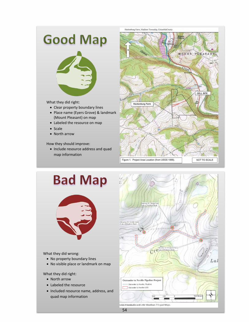
What they did right: • Clear property boundary lines • Place name (Eyers Grove) & landmark
(Mount Pleasant) on map • Labeled the resource on map • Scale • North arrow
How they should improve: • Include resource address and quad
map information
What they did wrong: • No property boundary lines • No visible place or landmark on map
What they did right: • North arrow • Labeled the resource • Included resource name, address, and
quad map information
54
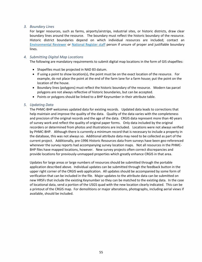
3. Boundary Lines For larger resources, such as farms, airports/airstrips, industrial sites, or historic districts, draw clear boundary lines around the resource. The boundary must reflect the historic boundary of the resource. Historic district boundaries depend on which individual resources are included; contact an Environmental Reviewer or National Register staff person if unsure of proper and justifiable boundary lines.
4. Submitting Digital Map Locations The following are mandatory requirements to submit digital map locations in the form of GIS shapefiles:
• Shapefiles must be projected in NAD 83 datum. • If using a point to show location(s), the point must be on the exact location of the resource. For
example, do not place the point at the end of the farm lane for a farm house; put the point on the location of the house.
• Boundary lines (polygons) must reflect the historic boundary of the resource. Modern tax parcel polygons are not always reflective of historic boundaries, but can be accepted.
• Points or polygons should be linked to a BHP Keynumber in their attribute table.
5. Updating Data The PHMC-BHP welcomes updated data for existing records. Updated data leads to corrections that help maintain and improve the quality of the data. Quality of the data varies with the completeness and precision of the original records and the age of the data. CRGIS data represent more than 40 years of survey work and reflect the quality of original paper forms. Only data included by the original recorders or determined from photos and illustrations are included. Locations were not always verified by PHMC-BHP. Although there is currently a minimum record that is necessary to include a property in the database, this was not always so. Additional attribute data may need to be collected as part of the current project. Additionally, pre-1996 Historic Resources data from surveys have been geo-referenced whenever the survey reports had accompanying survey location maps. Not all resources in the PHMC-BHP files have mapped locations, however. New survey projects often correct discrepancies and provide locations for previously-unmapped properties which greatly enhance CRGIS in that area.
Updates for large areas or large numbers of resources should be submitted through the portable application described above. Individual updates can be submitted through the feedback button in the upper right corner of the CRGIS web application. All updates should be accompanied by some form of verification that can be included in the file. Major updates to the attribute data can be submitted on new HRSFs that include the existing Keynumber so they can be matched to the existing data. In the case of locational data, send a portion of the USGS quad with the new location clearly indicated. This can be a printout of the CRGIS map. For demolitions or major alterations, photographs, including aerial views if available, should be included.
55

Portable Data Entry
To streamline the collection of data for large areas and/or many resources, the PHMC-BHP developed a portable application, a Microsoft Access version of the CRGIS database. This file includes data entry forms and reports that allow users to print out individual forms for each resource and inventories for districts. The database permits mapping, text, and photography to be linked to the survey data electronically. It can be used both to update existing records and to add new resources to the BHP files. There are several advantages to this process. It reduces the possibility of duplicating data that already exists in the CRGIS database. It makes data collection more uniform across survey projects. It eliminates the need for the PHMC-BHP to re-enter data that the surveyor has already collected digitally. It ensures that all survey material received will be useful to the BHP in order to carry out its survey responsibilities under the National Historic Preservation Act of 1966 as amended. Surveyors conducting regional survey or survey of large project areas for Environmental Review compliance are eligible to use this portable application. Staff recommends that surveyors use the database for any project that will produce more than 20 new resource forms or for areas that have significant previous survey data that need to be updated. All grant-funded surveys must use the BHP CRGIS database and comply with BHP survey standards. PHMC-BHP will not accept survey information unless it conforms to BHP filing, database, and GIS conventions. While planning the survey, start by contacting the PHMC-BHP staff member who will review the data submitted. This may be the regional National Register staff person or Environmental Reviewer or Community Preservation Coordinator. Staff can determine if the portable application is appropriate for the project and provide a data request form if necessary. Although the portable application is designed to allow users to collect all the data fields that are included in the main database, not all fields are necessary for every level of survey. The staff member will help determine what the minimum and standard records will be for the project. Upon acceptance of the request, PHMC-BHP will provide an electronic survey database of existing records in the specified survey area and the GIS data for those resources. BHP will also provide training and instructions for using the database. At the end of the survey, the updated data set is returned to the BHP, along with the appropriate GIS mapping data and images for the resources recorded. The data can then be uploaded into the CRGIS. Please note that returning the dataset does not replace submitting paper copies of forms and maps, as required elsewhere in this document. These forms, though, can be generated by the Access report function. Provision is made for producing both long and short forms.
56

CRGIS Data Sharing Protocols
Project Specific Data Requests There are two main reasons for BHP to enter into a data sharing agreement: for analysis of the data and for planning purposes. Because data concerning all of the resources in our files are available for viewing through the CRGIS, we reserve the process of data extraction and exporting for projects that will either lead to the enhancement of the data or involve levels of data analysis not available through the web interface. Also, the data in our files are constantly being updated through the addition of new resources and the evaluation of those already recorded. Therefore, the following criteria will be used to determine whether a data request can be filled:
1. Has the requestor consulted a member of the PHMC-BHP program staff to determine what data we have that they need for the project?
2. Is the project using the portable application? 3. Does the project for which the data is being requested have a defined end date within the next year after
which the data will be either updated or deleted? Any project lasting more than one year must include a plan for updating the data.
4. Does the project cover a large or resource-dense area that would be difficult to inspect using the CRGIS?
We would not recommend a data extraction if it will take us longer to run the queries than it would take the requestor to extract the data by hand from the CRGIS.
5. Does the project require the analysis of data in our files that cannot be exported from CRGIS?
Data requests may be made for either spatial or non-spatial data or both. Requestors must sign the agreement that indicates that they are receiving the data as is and that they understand the data quality statement and restrictions on use. Any additions or corrections that they make to the data are to be submitted to us at the end of the project. The most common uses of the data request are for historic surveys that are using our portable application for data collection and survey for very large projects, such as major pipeline corridors or highway planning alternatives mapping.
Long-Term Data Sharing Agreements Since historic preservation is most effective when it is incorporated into local planning efforts, we are developing a program to share data with local planning entities that are willing to enter into a long term agreement that includes sharing information and updating data on a regular schedule. We are still developing the procedures, but the following are criteria we use to determine whether a partnership is possible:
1. Does the requesting organization have an ongoing role in developing or reviewing plans that can affect historic resources?
2. Is there a reason why it is not possible for them to use the online CRGIS in their review process? 3. Do they understand the limitations of our data in their area? We recommend that they work with one of
our Community Preservation Coordinators prior to developing a data sharing agreement. We also provide training for local staff upon request.
57

4. Will the data be used in a GIS environment? PHMC-BHP does not encourage the development of static maps of historic resources, since they are outdated as soon as they are published. We do not provide data for a process that will be used for more than one year unless there is a plan for updating the data.
5. Are they willing to provide locational data that will help us map resources in their area that are currently
unmapped in our files?
58

APPENDIX
59
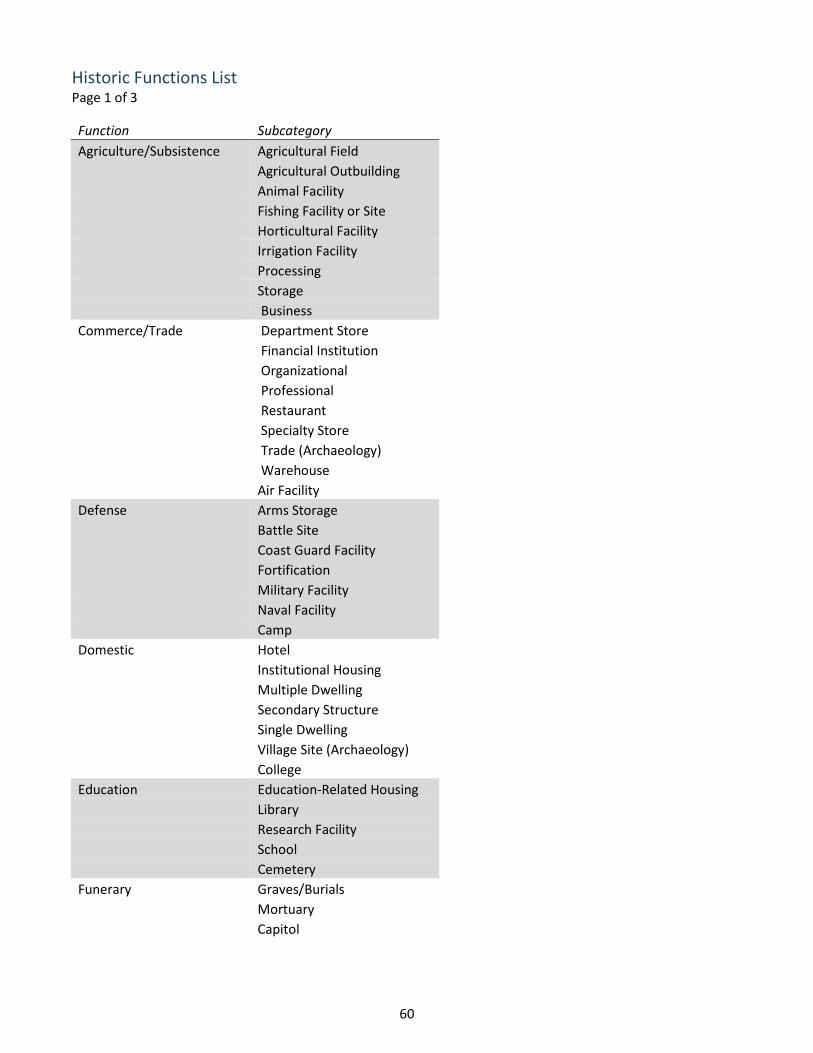
Historic Functions List Page 1 of 3
Function Subcategory Agriculture/Subsistence Agricultural Field Agricultural Outbuilding Animal Facility Fishing Facility or Site Horticultural Facility Irrigation Facility Processing Storage Business Commerce/Trade Department Store
Financial Institution
Organizational
Professional
Restaurant
Specialty Store
Trade (Archaeology)
Warehouse
Air Facility
Defense Arms Storage Battle Site Coast Guard Facility Fortification Military Facility Naval Facility Camp Domestic Hotel
Institutional Housing
Multiple Dwelling
Secondary Structure
Single Dwelling
Village Site (Archaeology)
College
Education Education-Related Housing Library Research Facility School Cemetery Funerary Graves/Burials
Mortuary
Capitol
60

Historic Functions List Page 2 of 3 Function Subcategory Government City Hall Correctional Facility Courthouse Custom House Diplomatic Building Fire Station Governmental Office Post Office Public Works Clinic Health Care Hospital
Medical Business/Office
Resort
Sanitarium
Communications Facility
Industry/Processing/Extract Energy Facility Extractive Facility Manufacturing Facility
Processing Site (Archaeology)
Waterworks Conservation Area Landscape Forest
Garden
Natural Feature
Park
Parking Lot
Plaza
Street Furniture/Object
Underwater
Unoccupied Land
Other Auditorium Recreation and Culture Fair
Monument/Marker
Museum
Music Facility
Outdoor Recreation
Sports Facility
Theater
Work of Art
Ceremonial Site
61
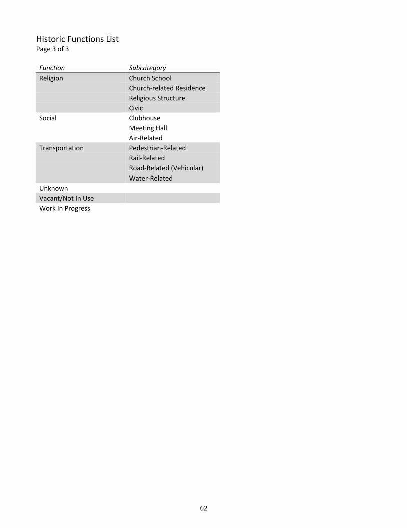
Historic Functions List Page 3 of 3 Function Subcategory Religion Church School Church-related Residence Religious Structure Civic Social Clubhouse
Meeting Hall
Air-Related
Transportation Pedestrian-Related Rail-Related Road-Related (Vehicular) Water-Related Unknown
Vacant/Not In Use Work In Progress
62

Criteria for Determining Appropriate Mitigation
DRAFT Criteria for Determining Appropriate Mitigation
*Please note not all criteria need to be met
1. Public benefit • NHPA recognizes preservation is a public interest • Will it give back to the community in which the resource is located?
2. Significance of the property
• Significant properties warrant more consideration/mitigation • Is the property an NHL? • Is the property of national significance? • Number of similar historic properties that remain • Relevant to property type
3. Accommodates needs of all parties
• Most especially those who ascribe value to a property
4. Enhance knowledge of and protection of historic properties
5. Cost • Proportionate to the property’s significance and integrity and the effects of the project • Can you justify to tax payers why solution is in public interest?
63

Checklist for Planning and Conducting Survey Page 1 of 3
1. Understand the Goal and Deliverables - Clearly stating reasons for conducting the survey will influence the type, amount, and complexity of the information you collect beyond the minimum record (the Abbreviated HRSF).
What is the appropriate level of survey for your project?
What is the survey area for your project?
What is the deliverable, or product, at the end of this survey? Example: To facilitate compliance projects, to prepare tourist materials such as walking
tour brochures, to create a baseline record for planning decisions by the municipality, to identify potential resources for listing in the National Register
2. Think Holistically - seek to capture information about all the resources that reflect the development of the survey area/theme. Do not be arbitrary in what you select to survey.
Do the surveyed properties reflect the entire character of the area/theme?
3. Prepare Carefully - DON’T start before you have an understanding of your survey area/theme's history.
What kind of places do you expect to encounter?
What periods of development are reflected in the area/theme?
4. Think Long Term - you are creating a record that should remain useful for decades. Try to capture information that may not seem important now but might be in the future.
How can this information be useful in twenty or thirty years?
Example: Baseline for future researcher's understanding of the resource's integrity in the 21st century
64
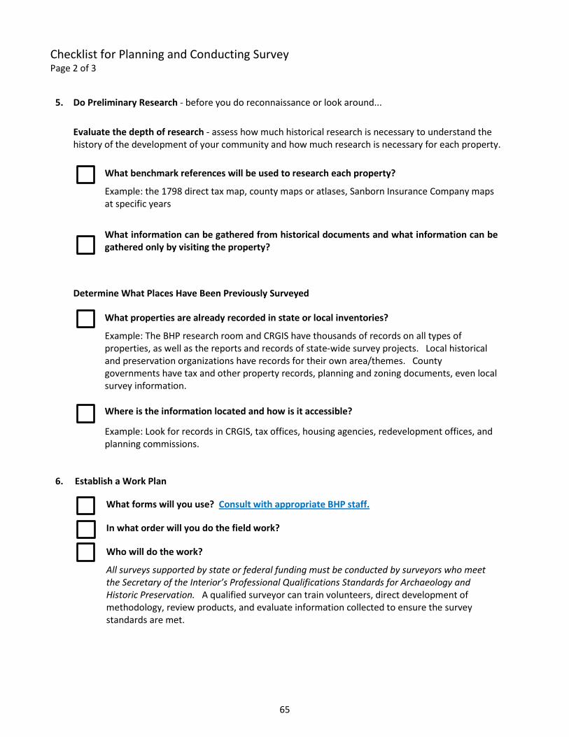
Checklist for Planning and Conducting Survey Page 2 of 3
5. Do Preliminary Research - before you do reconnaissance or look around...
Evaluate the depth of research - assess how much historical research is necessary to understand the history of the development of your community and how much research is necessary for each property.
What benchmark references will be used to research each property?
Example: the 1798 direct tax map, county maps or atlases, Sanborn Insurance Company maps at specific years
What information can be gathered from historical documents and what information can be gathered only by visiting the property?
Determine What Places Have Been Previously Surveyed
What properties are already recorded in state or local inventories?
Example: The BHP research room and CRGIS have thousands of records on all types of properties, as well as the reports and records of state-wide survey projects. Local historical and preservation organizations have records for their own area/themes. County governments have tax and other property records, planning and zoning documents, even local survey information.
Where is the information located and how is it accessible? Example: Look for records in CRGIS, tax offices, housing agencies, redevelopment offices, and
planning commissions.
6. Establish a Work Plan
What forms will you use? Consult with appropriate BHP staff.
In what order will you do the field work?
Who will do the work? All surveys supported by state or federal funding must be conducted by surveyors who meet
the Secretary of the Interior’s Professional Qualifications Standards for Archaeology and Historic Preservation. A qualified surveyor can train volunteers, direct development of methodology, review products, and evaluate information collected to ensure the survey standards are met.
65
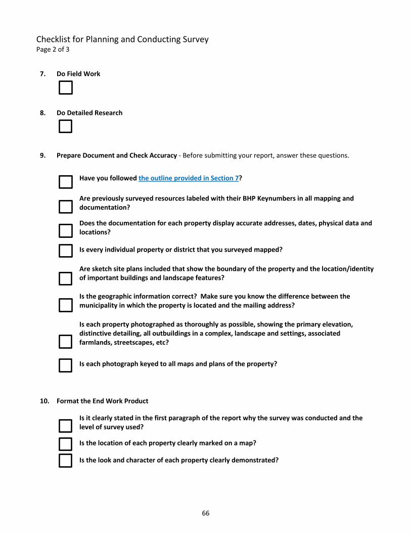
Checklist for Planning and Conducting Survey Page 2 of 3
7. Do Field Work
8. Do Detailed Research
9. Prepare Document and Check Accuracy - Before submitting your report, answer these questions.
Have you followed the outline provided in Section 7?
Are previously surveyed resources labeled with their BHP Keynumbers in all mapping and documentation?
Does the documentation for each property display accurate addresses, dates, physical data and locations?
Is every individual property or district that you surveyed mapped?
Are sketch site plans included that show the boundary of the property and the location/identity of important buildings and landscape features?
Is the geographic information correct? Make sure you know the difference between the municipality in which the property is located and the mailing address?
Is each property photographed as thoroughly as possible, showing the primary elevation, distinctive detailing, all outbuildings in a complex, landscape and settings, associated farmlands, streetscapes, etc?
Is each photograph keyed to all maps and plans of the property?
10. Format the End Work Product
Is it clearly stated in the first paragraph of the report why the survey was conducted and the level of survey used?
Is the location of each property clearly marked on a map?
Is the look and character of each property clearly demonstrated?
66