göttingen & windhoek - biodiversity-plants.de · isto sugere que as actividades mineiras...
TRANSCRIPT

© University of Hamburg 2018 All rights reserved
Klaus Hess PublishersGöttingen & Windhoekwww.k-hess-verlag.de
ISBN: 978-3-933117-95-3 (Germany), 978-99916-57-43-1 (Namibia)
Language editing: Will Simonson (Cambridge), and Proofreading PalTranslation of abstracts to Portuguese: Ana Filipa Guerra Silva Gomes da PiedadePage desing & layout: Marit Arnold, Klaus A. Hess, Ria Henning-LohmannCover photographs: front: Thunderstorm approaching a village on the Angolan Central Plateau (Rasmus Revermann) back: Fire in the miombo woodlands, Zambia (David Parduhn)Cover Design: Ria Henning-Lohmann
ISSN 1613-9801
Printed in Germany
Suggestion for citations:Volume:Revermann, R., Krewenka, K.M., Schmiedel, U., Olwoch, J.M., Helmschrot, J. & Jürgens, N. (eds.) (2018) Climate change and adaptive land management in southern Africa – assessments, changes, challenges, and solutions. Biodiversity & Ecology, 6, Klaus Hess Publishers, Göttingen & Windhoek. Articles (example):Archer, E., Engelbrecht, F., Hänsler, A., Landman, W., Tadross, M. & Helmschrot, J. (2018) Seasonal prediction and regional climate projections for southern Africa. In: Climate change and adaptive land management in southern Africa – assessments, changes, challenges, and solutions (ed. by Revermann, R., Krewenka, K.M., Schmiedel, U., Olwoch, J.M., Helmschrot, J. & Jürgens, N.), pp. 14–21, Biodiversity & Ecology, 6, Klaus Hess Publishers, Göttingen & Windhoek.
Corrections brought to our attention will be published at the following location: http://www.biodiversity-plants.de/biodivers_ecol/biodivers_ecol.php

Biodiversity & EcologyJournal of the Division Biodiversity, Evolution and Ecology of Plants, Institute for Plant Science and Microbiology, University of Hamburg
Volume 6:
Climate change and adaptive land management in southern Africa
Assessments, changes, challenges, and solutions
Edited by
Rasmus Revermann1, Kristin M. Krewenka1, Ute Schmiedel1, Jane M. Olwoch2, Jörg Helmschrot2,3, Norbert Jürgens1
1 Institute for Plant Science and Microbiology, University of Hamburg 2 Southern African Science Service Centre for Climate Change and Adaptive Land Management
3 Department of Soil Science, Faculty of AgriSciences, Stellenbosch University
Hamburg 2018
RPlease cite the article as follows:
Nyambe, I., Chabala, A., Banda, K., Zimba, H. & Phiri, W. (2018) Determinants of spatio-temporal
variability of water quality in the Barotse Floodplain, western Zambia. In: Climate change and
adaptive land management in southern Africa – assessments, changes, challenges, and solutions
(ed. by Revermann, R., Krewenka, K.M., Schmiedel, U., Olwoch, J.M., Helmschrot, J. & Jürgens,
N.), pp. 96-105, Biodiversity & Ecology, 6, Klaus Hess Publishers, Göttingen & Windhoek.
doi:10.7809/b-e.00310

Wat
er re
sour
ces
96 C A
Abstract: Developing a water quality database for the Upper Zambezi Basin is becoming crucial for ensuring strengthened water resources monitoring and management in the face of potential threats posed by anthropogenically induced eff ects of land use and climate change. To realise this goal, it is important to establish factors that control the variation of water qual-ity. Thus, in this study, we analysed water quality and stream sediment parameters to infer their spatio-temporal variation between 2014 and 2015 in the Barotse Floodplain, western Zambia. It was found that the concentrations of heavy metals (i.e., copper, lead, cadmium, mercury, arsenic, zinc, and chromium) were mostly below detection limits (< 0.002 mg/l) and fell within the World Health Organization (WHO) and Zambia Bureau of Standards (ZABS) guidelines for drinking water. This suggested that current large-scale mining activities taking place upstream of the Barotse Floodplain have no eff ect on this important water resource. It was the potentially geogenically derived elements, particularly calcium, that were observed to be predominant and appeared to be infl uenced by physical parameters, especially pH. Seasonal nutrient recruitment was also noted to be active and attributed to land use change and fl ood inundation patterns. Nitrates spiked up to > 24 mg/l in the year 2014, which experienced higher fl oods. This value dropped to < 0.5 mg/l in 2015, possibly as a result of below-normal rainfall that led to lower fl oods. Analysis of bacteriological results indicated that anthropogenic activities aff ected water quality. All sampling points close to communities registered a too-numerous-to-count (TNTC) concentration of faecal and total coliforms (> 200 coliforms/100 ml). An assessment of the sediment yields predicted by the Soil and Water Assessment Tool (SWAT) and measured turbidity suggested the likely existence of a stronger relationship in the upstream areas and near the confl uence of the Zambezi and the Luanginga Rivers than within and after the main fl oodplain. Because of the limited sampling period, however, this phenomenon was not conclusively assessed. Nevertheless, the observed lower turbidity levels and element concentrations in the fl oodplain may be a strong indicator of a critical role that the Barotse Floodplain plays as a natural sink.
Resumo: É cada vez mais crucial o desenvolvimento de uma base de dados sobre a qualidade da água da bacia superior do Zambezi, de modo a garantir a monitorização e gestão reforçada dos recursos hídricos face a potenciais ameaças, causadas pelos efeitos antropogénicos resultantes do uso das terras e das alterações climáticas. De modo a materializar este objectivo, é importante estabelecer factores que controlam a variação da qualidade da água. Assim, neste estudo, analisámos a quali-dade da água e os parâmetros dos sedimentos da corrente, de modo a inferir a sua variação espacio-temporal entre 2014 e 2015 na Planície Aluvial de Barotse, na Zâmbia Ocidental. Verifi cou-se que as concentrações de metais pesados (i.e. cobre, chumbo, cádmio, mercúrio, arsénio, zinco e crómio) encontravam-se essencialmente abaixo dos limites de detecção (< 0.002 mg/l), sendo abrangidas pelas normas da Organização Mundial da Saúde (OMS) e da Zambia Bureau of Standards (ZABS) para a água potável. Isto sugere que as actividades mineiras actuais de grande escala a decorrerem a montante da Planície Aluvial de Barotse não têm nenhum efeito neste importante recurso hídrico. Os elementos potencialmente geogénicos, par-ticularmente o cálcio, foram observados como predominantes, parecendo ser infl uenciados por parâmetros físicos, em espe-cial o pH. O recrutamento sazonal de nutrientes foi também observado como activo e atribuído às alterações do uso da terra e aos padrões de inundação. Os nitratos aumentaram até > 24 mg/l no ano de 2014, o qual sofreu inundações mais elevadas. Este valor caiu para < 0,5 mg/l em 2015, possivelmente devido à ocorrência de precipitação abaixo do normal, que resultou em inundações menos acentuadas. A análise dos resultados bacteriológicos indicou que as actividades antropogénicas afec-taram a qualidade da água. Todos os pontos de amostragem perto de comunidades registaram concentrações de coliformes
Determinants of spatio-temporal variability of water quality in the Barotse Floodplain, western ZambiaImasiku Nyambe1*, Anthony Chabala1, Kawawa Banda1, Henry Zimba1, Wilson Phiri1
1 Integrated Water Resources Management Centre, University of Zambia, Lusaka 10101, Zambia
* Corresponding author: [email protected]
Wat
er re
sour
ces
B E 6 2018 97
Introduction
Floodplains are of great cultural and eco-nomic importance, as most early civilisa-tions arose in fertile fl oodplains (Polunin, 2014). Throughout history, people have exploited the fl oodplains for their rich resources, particularly the alluvial soils, which support crop production. Conse-quently, fl oodplains have served as focal points for urban development (Naiman et al., 2005). Floodplains are described as dynamic systems that are shaped by repeated erosion and deposition of sedi-ments, inundation or prolonged hydro-periods during rising water levels, and complex ground-surface water exchange processes. This dynamic nature makes fl oodplains among the most biologi-cally productive and diverse ecosystems on Earth (Gregory et al., 1991; Naiman & Décamps, 1997; Tockner & Stanford, 2002; Naiman et al., 2005). A study of the spatial extent of all tropical wetlands re-
veals that 2.5 to 3.5% of Earth’s surface is wetlands, with areas of > 106 km2 in South America and 105 km2 in Africa (Tockner & Stanford, 2002; Zuijdgeest et al., 2015).
Wetlands or fl oodplains are widely regarded as important locations for the uptake and transformation of nutrients and sediment in fl uvial landscapes (Noe & Hupp, 2007). Research by Ahiablame et al. (2010) describes sediments as prob-ably the most infl uential determinant of the ability of the system to process and sustain nutrient loads. This is because fl oodplains are frequently thought of as sinks of inorganic nutrients and sources of organic nutrients — in other words, nu-trient transformers (Noe & Hupp, 2007). Moreover, many agrochemicals, heavy metals, and nutrients chemically bind to sediments, which provide a transport mechanism for these contaminants as well as substrate where they react (Lovett et al., 2007). Zuijdgeest et al. (2015) also crucially point out that fl ows are restrict-
ed in most lakes and fl oodplains systems; hence, particles have time to settle.
The agrochemical, heavy metal, and nutrient contaminants may be caused by anthropogenic perturbations, which can lead to alterations of the physical, chemi-cal, and biological properties of the water body (Bilotta & Brazier, 2008). Nutrient contaminants can be categorised with re-spect to where they are being discharged. Writing on ‘modeling the relationship between land use and surface water qual-ity’, Tong & Chen (2002) state that runoff from diff erent types of land use may be enriched with diff erent kinds of contami-nants, which may come from agricultural lands enriched with nutrients, highly de-veloped urban areas (mines inclusive) enriched with rubber fragments, oil, and heavy metals as well as sodium and sul-phates from road de-icers. Only contami-nants resulting from agricultural land use and mining activities are relevant in the present study area.
In this study, we assessed spatio-tem-poral variations in water quality param-eters of the Barotse Floodplain in light of increasing anthropogenic activities such as farming around this water resource, and mining activities upstream in the Kabombo River Basin of north-western Zambia.
Study location
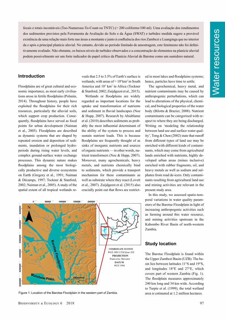
The Barotse Floodplain is found within the Upper Zambezi Basin (UZB). The ba-sin lies between latitudes 11°S and 19°S, and longitudes 18°E and 27°E, which covers part of western Zambia (Fig. 1). The fl oodplain measures approximately 240 km long and 34 km wide. According to Turpie et al. (1999), the total wetland area is estimated at 1.2 million hectares.
fecais e totais incontáveis (Too-Numerous-To-Count ou TNTC) (> 200 coliforms/100 ml). Uma avaliação dos rendimentos dos sedimentos previstos pela Ferramenta de Avaliação do Solo e da Água (SWAT) e turbidez medida sugere a provável existência de uma relação mais forte nas áreas a montante e junto à confl uência dos rios Zambezi e Luanginga que no interior da e após a principal planície aluvial. No entanto, devido ao período limitado de amostragem, este fenómeno não foi defi ni-tivamente avaliado. Não obstante, os baixos níveis de turbidez observados e a concentração de elementos na planície aluvial podem possivelmente ser um forte indicador do papel crítico da Planície Aluvial de Barotse como um sumidoro natural.
Figure 1: Location of the Barotse Floodplain in the western part of Zambia.
Wat
er re
sour
ces
98 C A
Methods
In this study, surface water quality and stream sediments of the Barotse Flood-plain were characterised during low and high fl ows. Water samples were collected across the fl oodplain and tested for their physical, bacteriological, and chemical characteristics. These samples were col-lected in triplicate at each point and pre-served for diff erent laboratory analyses: one sample for anion analysis, another for cation analysis, and the third for bacte-riological analysis. Two percent (2%) of 250 ml of nitric acid was added to water samples meant for cation analysis. Acidi-fi cation of water samples preserved most trace metals and reduced precipitation, microbial activity, and sorption losses to container walls. Bacteriological sam-ples were taken in glass bottles whereas physiochemical samples were stored in plastic bottles. The principal method used for bacteriological analysis was the membrane fi ltration (MF) method.
Before the collection of water sam-ples, the bottles were rinsed three times together with their respective lids. The depth at which the samples were col-lected was approximately 50 cm from the water surface, and the same water was used for rinsing. The samples were im-mediately put into cooler boxes contain-ing ice packs upon completing the collec-tion protocols at each site. In addition, in situ measurements were simultaneously conducted using multi-metres. Multi-metres measured the following physical parameters: dissolved oxygen (DO), tem-perature, electrical conductivity (EC), and pH. The samples preserved for labo-ratory analyses were transported to the University of Zambia within 48 hours. A record of each sampled site was created by taking photographs and geographical coordinates. The latter were also used to plot the sampling points using ArcGIS.
Stream sediment samples were col-lected alongside water quality samples. These two sample types were mostly col-lected at the same locations. Where it was not practical to collect them at the same water quality locations, an alternative site was chosen within a few metres. These samples were collected using a perforated scoop. They were immediately closed in
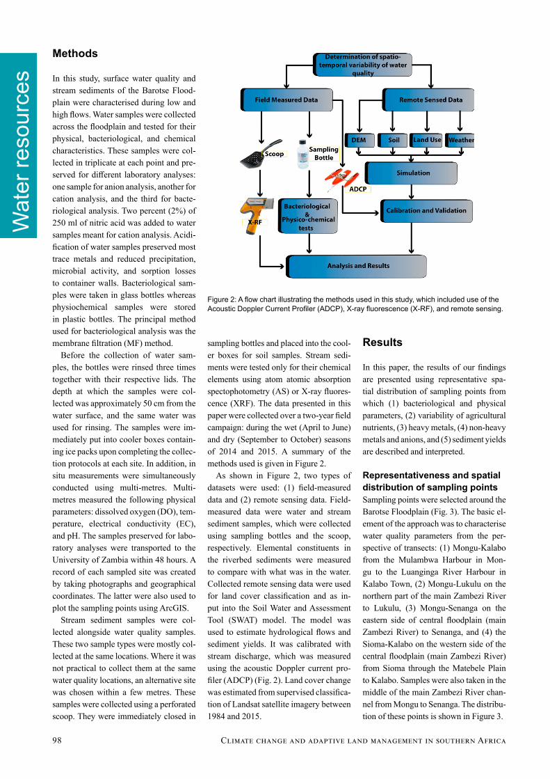
sampling bottles and placed into the cool-er boxes for soil samples. Stream sedi-ments were tested only for their chemical elements using atom atomic absorption spectophotometry (AS) or X-ray fl uores-cence (XRF). The data presented in this paper were collected over a two-year fi eld campaign: during the wet (April to June) and dry (September to October) seasons of 2014 and 2015. A summary of the methods used is given in Figure 2.
As shown in Figure 2, two types of datasets were used: (1) fi eld-measured data and (2) remote sensing data. Field-measured data were water and stream sediment samples, which were collected using sampling bottles and the scoop, respectively. Elemental constituents in the riverbed sediments were measured to compare with what was in the water. Collected remote sensing data were used for land cover classifi cation and as in-put into the Soil Water and Assessment Tool (SWAT) model. The model was used to estimate hydrological fl ows and sediment yields. It was calibrated with stream discharge, which was measured using the acoustic Doppler current pro-fi ler (ADCP) (Fig. 2). Land cover change was estimated from supervised classifi ca-tion of Landsat satellite imagery between 1984 and 2015.
Results
In this paper, the results of our fi ndings are presented using representative spa-tial distribution of sampling points from which (1) bacteriological and physical parameters, (2) variability of agricultural nutrients, (3) heavy metals, (4) non-heavy metals and anions, and (5) sediment yields are described and interpreted.
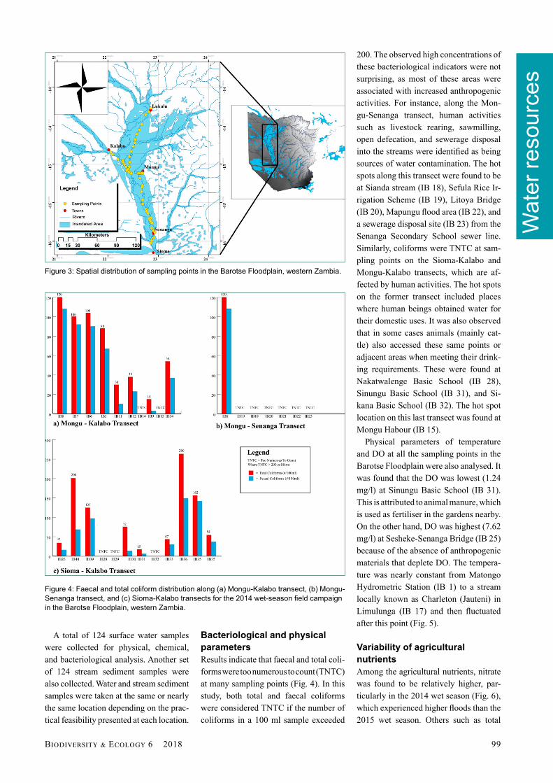
Representativeness and spatial distribution of sampling pointsSampling points were selected around the Barotse Floodplain (Fig. 3). The basic el-ement of the approach was to characterise water quality parameters from the per-spective of transects: (1) Mongu-Kalabo from the Mulambwa Harbour in Mon-gu to the Luanginga River Harbour in Kalabo Town, (2) Mongu-Lukulu on the northern part of the main Zambezi River to Lukulu, (3) Mongu-Senanga on the eastern side of central fl oodplain (main Zambezi River) to Senanga, and (4) the Sioma-Kalabo on the western side of the central fl oodplain (main Zambezi River) from Sioma through the Matebele Plain to Kalabo. Samples were also taken in the middle of the main Zambezi River chan-nel from Mongu to Senanga. The distribu-tion of these points is shown in Figure 3.
Figure 2: A fl ow chart illustrating the methods used in this study, which included use of the Acoustic Doppler Current Profi ler (ADCP), X-ray fl uorescence (X-RF), and remote sensing.
Wat
er re
sour
ces
B E 6 2018 99
A total of 124 surface water samples were collected for physical, chemical, and bacteriological analysis. Another set of 124 stream sediment samples were also collected. Water and stream sediment samples were taken at the same or nearly the same location depending on the prac-tical feasibility presented at each location.
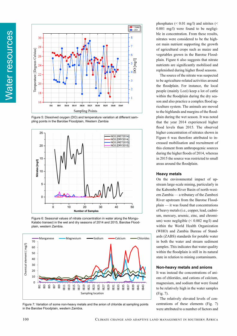
Bacteriological and physical parametersResults indicate that faecal and total coli-forms were too numerous to count (TNTC) at many sampling points (Fig. 4). In this study, both total and faecal coliforms were considered TNTC if the number of coliforms in a 100 ml sample exceeded
200. The observed high concentrations of these bacteriological indicators were not surprising, as most of these areas were associated with increased anthropogenic activities. For instance, along the Mon-gu-Senanga transect, human activities such as livestock rearing, sawmilling, open defecation, and sewerage disposal into the streams were identifi ed as being sources of water contamination. The hot spots along this transect were found to be at Sianda stream (IB 18), Sefula Rice Ir-rigation Scheme (IB 19), Litoya Bridge (IB 20), Mapungu fl ood area (IB 22), and a sewerage disposal site (IB 23) from the Senanga Secondary School sewer line. Similarly, coliforms were TNTC at sam-pling points on the Sioma-Kalabo and Mongu-Kalabo transects, which are af-fected by human activities. The hot spots on the former transect included places where human beings obtained water for their domestic uses. It was also observed that in some cases animals (mainly cat-tle) also accessed these same points or adjacent areas when meeting their drink-ing requirements. These were found at Nakatwalenge Basic School (IB 28), Sinungu Basic School (IB 31), and Si-kana Basic School (IB 32). The hot spot location on this last transect was found at Mongu Habour (IB 15).
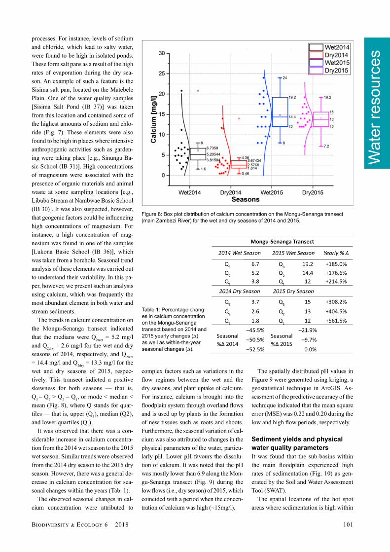
Physical parameters of temperature and DO at all the sampling points in the Barotse Floodplain were also analysed. It was found that the DO was lowest (1.24 mg/l) at Sinungu Basic School (IB 31). This is attributed to animal manure, which is used as fertiliser in the gardens nearby. On the other hand, DO was highest (7.62 mg/l) at Sesheke-Senanga Bridge (IB 25) because of the absence of anthropogenic materials that deplete DO. The tempera-ture was nearly constant from Matongo Hydrometric Station (IB 1) to a stream locally known as Charleton (Jauteni) in Limulunga (IB 17) and then fl uctuated after this point (Fig. 5).
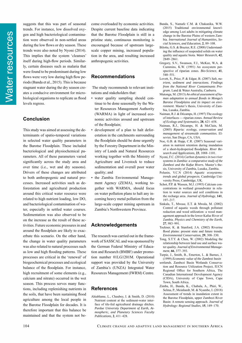
Variability of agricultural nutrientsAmong the agricultural nutrients, nitrate was found to be relatively higher, par-ticularly in the 2014 wet season (Fig. 6), which experienced higher fl oods than the 2015 wet season. Others such as total
Figure 3: Spatial distribution of sampling points in the Barotse Floodplain, western Zambia.
Figure 4: Faecal and total coliform distribution along (a) Mongu-Kalabo transect, (b) Mongu-Senanga transect, and (c) Sioma-Kalabo transects for the 2014 wet-season fi eld campaign in the Barotse Floodplain, western Zambia.
Wat
er re
sour
ces
100 C A
phosphates (< 0.01 mg/l) and nitrites (< 0.001 mg/l) were found to be negligi-ble in concentration. From these results, nitrates were considered to be the high-est main nutrient supporting the growth of agricultural crops such as maize and vegetables grown in the Barotse Flood-plain. Figure 6 also suggests that nitrate nutrients are signifi cantly mobilised and replenished during higher fl ood seasons.
The source of the nitrate was suspected to be agriculture-related activities around the fl oodplain. For instance, the local people (mainly Lozi) keep a lot of cattle within the fl oodplain during the dry sea-son and also practice a complex fl ood ag-riculture system. The animals are moved to the highlands and margins of the fl ood-plain during the wet season. It was noted that the year 2014 experienced higher fl ood levels than 2015. The observed higher concentration of nitrates shown in Figure 6 was therefore attributed to in-creased mobilisation and recruitment of this element from anthropogenic sources during the higher fl oods of 2014, whereas in 2015 the source was restricted to small areas around the fl oodplain.
Heavy metalsOn the environmental impact of up-stream large-scale mining, particularly in the Kabombo River Basin of north-west-ern Zambia — a tributary of the Zambezi River upstream from the Barotse Flood-plain — it was found that concentrations of heavy metals (i.e., copper, lead, cadmi-um, mercury, arsenic, zinc, and chromi-um) were negligible (< 0.002 mg/l) and within the World Health Organization (WHO) and Zambia Bureau of Stand-ards (ZABS) standards for potable water in both the water and stream sediment samples. This indicates that water quality within the fl oodplain is still in its natural state in relation to mining contaminants.
Non-heavy metals and anionsIt was instead the concentrations of ani-ons of chlorides, and cations of calcium, magnesium, and sodium that were found to be relatively high in the water samples (Fig. 7).
The relatively elevated levels of con-centrations of these elements (Fig. 7) were attributed to a number of factors and
Figure 6: Seasonal values of nitrate concentration in water along the Mongu-Kalabo transect in the wet and dry seasons of 2014 and 2015, Barotse Flood-plain, western Zambia.
Figure 7: Variation of some non-heavy metals and the anion of chloride at sampling points in the Barotse Floodplain, western Zambia.
Figure 5: Dissolved oxygen (DO) and temperature variation at diff erent sam-pling points in the Barotse Floodplain, Western Zambia
Wat
er re
sour
ces
B E 6 2018 101
processes. For instance, levels of sodium and chloride, which lead to salty water, were found to be high in isolated ponds. These form salt pans as a result of the high rates of evaporation during the dry sea-son. An example of such a feature is the Sisima salt pan, located on the Matebele Plain. One of the water quality samples [Sisima Salt Pond (IB 37)] was taken from this location and contained some of the highest amounts of sodium and chlo-ride (Fig. 7). These elements were also found to be high in places where intensive anthropogenic activities such as garden-ing were taking place [e.g., Sinungu Ba-sic School (IB 31)]. High concentrations of magnesium were associated with the presence of organic materials and animal waste at some sampling locations [e.g., Libuba Stream at Nambwae Basic School (IB 30)]. It was also suspected, however, that geogenic factors could be infl uencing high concentrations of magnesium. For instance, a high concentration of mag-nesium was found in one of the samples [Lukona Basic School (IB 36)], which was taken from a borehole. Seasonal trend analysis of these elements was carried out to understand their variability. In this pa-per, however, we present such an analysis using calcium, which was frequently the most abundant element in both water and stream sediments.
The trends in calcium concentration on the Mongu-Senanga transect indicated that the medians were Q2wet = 5.2 mg/l and Q2dry = 2.6 mg/l for the wet and dry seasons of 2014, respectively, and Q2wet = 14.4 mg/l and Q2dry = 13.3 mg/l for the wet and dry seasons of 2015, respec-tively. This transect indicted a positive skewness for both seasons — that is, Q3 – Q2 > Q2 – Q1, or mode < median < mean (Fig. 8), where Q stands for quar-tiles — that is, upper (Q3), median (Q2), and lower quartiles (Q1).
It was observed that there was a con-siderable increase in calcium concentra-tion from the 2014 wet season to the 2015 wet season. Similar trends were observed from the 2014 dry season to the 2015 dry season. However, there was a general de-crease in calcium concentration for sea-sonal changes within the years (Tab. 1).
The observed seasonal changes in cal-cium concentration were attributed to
complex factors such as variations in the fl ow regimes between the wet and the dry seasons, and plant uptake of calcium. For instance, calcium is brought into the fl oodplain system through overland fl ows and is used up by plants in the formation of new tissues such as roots and shoots. Furthermore, the seasonal variation of cal-cium was also attributed to changes in the physical parameters of the water, particu-larly pH. Lower pH favours the dissolu-tion of calcium. It was noted that the pH was mostly lower than 6.9 along the Mon-gu-Senanga transect (Fig. 9) during the low fl ows (i.e., dry season) of 2015, which coincided with a period when the concen-tration of calcium was high (~15mg/l).
The spatially distributed pH values in Figure 9 were generated using kriging, a geostatistical technique in ArcGIS. As-sessment of the predictive accuracy of the technique indicated that the mean square error (MSE) was 0.22 and 0.20 during the low and high fl ow periods, respectively.
Sediment yields and physical water quality parametersIt was found that the sub-basins within the main fl oodplain experienced high rates of sedimentation (Fig. 10) as gen-erated by the Soil and Water Assessment Tool (SWAT).
The spatial locations of the hot spot areas where sedimentation is high within
Figure 8: Box plot distribution of calcium concentration on the Mongu-Senanga transect (main Zambezi River) for the wet and dry seasons of 2014 and 2015.
Mongu-Senanga Transect
2014 Wet Season 2015 Wet Season Yearly % ∆
Q3 6.7 Q3 19.2 +185.0%Q2 5.2 Q2 14.4 +176.6%Q1 3.8 Q1 12 +214.5%
2014 Dry Season 2015 Dry Season
Q3 3.7 Q3 15 +308.2%Q2 2.6 Q2 13 +404.5%Q1 1.8 Q1 12 +561.5%
Seasonal %∆ 2014
–45.5%Seasonal %∆ 2015
–21.9%–50.5% –9.7%–52.5% 0.0%
Table 1: Percentage chang-es in calcium concentration on the Mongu-Senanga transect based on 2014 and 2015 yearly changes (∆) as well as within-the-year seasonal changes (∆).

Wat
er re
sour
ces
102 C A
the fl oodplain are shown in Figure 11. These areas (coloured brown) are sub-basins 140, 153, 157, and 158. Sub- basin 158 hosts the rice fi elds at Sefula Irriga-tion Scheme. The high rate of sediment accumulation has led to frequent clog-ging of irrigation channels in these fi elds.
The potential cause of increased sedi-mentation in the fl oodplain was attrib-uted to land cover changes as forested land was turned in agricultural land. A study by Zimba et al. (2018), which was conducted within the same broader framework (i.e., SASCCAL Task 191: Developing a water quality and quan-tity database for western Zambia) as the present work, found that between 1984 and 2015, forest cover declined by about
10%, which translates to an annual reduc-tion rate of about 0.3% (Fig. 12). Since the soil type in the area is sandy in nature, minor changes in forest cover can lead to high rates of sedimentation and an over-all change in water quality. Furthermore, conversion of forest to agricultural land and other uses was suspected to be an-other source of nutrients that enrich the fl oodplain in the wet season.
Further analysis was done on the wa-ter quality samples. This analysis was on the total solids (TS), which is a sum of total suspended solids (TSS) and to-tal dissolved solids (TDS). This calcula-tion was done to infer the conveyance of sediment within the fl oodwaters. Results (Fig. 13) show that the Mongu-Kalabo transect has more TS being transported during the wet season (April 2014) than
Figure 9: Spatially modelled pH distribution in the dry and wet seasons, Barotse Floodplain, western Zambia.
Figure 10: SWAT-estimated sediment ac-cumulation for the years 2001 to 2005 for the sub-basins falling within the Barotse Floodplain.
Figure 11: Spatial visualisation of the sub-basins highly impacted by sedimentation (brown-coloured areas), as simulated by the SWAT model.

Wat
er re
sour
ces
B E 6 2018 103
in the dry season (September 2014) ema-nating from the Luanginga River to the Zambezi River. Similar trends were ob-served along the other transects, particu-larly from Lukulu to Mongu and Mongu to Senanga.
It was observed that turbidity was high in the Luanginga River (Mongu-Kalabo transect) and main Zambezi River (Mon-
gu-Lukulu transect). This was attributed to the huge amount of sediment that is recruited as water from various tributary streams confl uence upstream from these rivers. Within the main fl oodplain, how-ever, vegetation acts like a porous barrier, forcing the sediments to be deposited on the riverbanks and sieving out some of the sediments. This process was assumed to be responsible for fi nally reducing turbid-ity within and after the fl oodplain along the Mongu-Senanga transect (Fig. 14).
Discussion
The variations in the chemical elements in the fl oodplain were noted to be closely linked to fl ood inundation patterns. This trend included high nitrate and calcium concentrations attributed to recruitment occurring during higher fl oods. These fi ndings are in agreement with previous studies conducted in the same area. For instance, Zurbrügg (2012), who studied the biogeochemistry of the Barotse Flood-plain and the dam-impacted Kafue Wet-land, observed a high seasonal variability in calcium concentration. Similarly, Zui-jdgeest et al. (2015) found high concentra-tions of nitrate in the fl ood season in the Barotse Floodplain. They also observed that other agricultural nutrients such as phosphorus were largely close to the limit of detection. It should be noted, however, that the aforementioned studies did not attribute the variability of these elements to any particular processes. Nevertheless,
our hypothesis that the variability of ele-ments is associated with fl ooding patterns is reasonably supported by numerous studies on fundamental processes of wet-land functions. For instance, it has been shown (e.g., Sinkala et al., 2002) that the variability of elements in a wetland is part of natural processes that serve to maintain the unique ecological functions of these water bodies. Schot & Wassen (1993) not-ed that fl oodplains tend to have dense veg-etation during the wet season, as the avail-able calcium supports tissue development.
The observed low levels of mining-related element concentration suggested that the water quality of the fl oodplain is not yet under threat from the mining sources of contamination in the northern part of the basin. Zuijdgeest et al. (2015) noted that the Kafue Flats and the Barotse Floodplain diff er in anthropogenic infl u-ence and considered the latter to be pris-tine in large parts. This view was also upheld by other researchers such as Zur-brügg (2012) and Nyoni (2014).
Anthropogenic economic activities (e.g., farming, wetland grazing, and defor-estation) within the fl oodplain seem to be the major predicators of biophysical wa-ter parameters. It was noted that sampling points near settled areas registered high peaks of bacteriological contamination. Since the Barotse Floodplain is a major source of livelihood for the local people, it is expected that such anthropogenic pollu-tion will increase with population growth. An increase in population means that a signifi cant part of the fl oodplain will be overexploited for its rich resources, which include fertile soils, fauna, and fl ora. For instance, sedimentation in some of the locations (e.g., Sefula Rice Scheme) was found to be signifi cantly high and was attributed to increased conversion of for-est to agricultural land. The number of people settling in the fl oodplain has since been increasing steadily. Mutonga (2013) has also noted that sedimentation in the Barotse Floodplain will likely increase with population growth and that unpre-dictable fl oods arising from climate varia-bility will exacerbate diseases and hunger because of the destruction of crops.
Although anthropogenic activities were noted to have adverse eff ects on biophysical water quality, evidence also
Figure 12: Land cover change between 1984 and 2015 in the Barotse sub-basin, western Zambia (Zimba et al., 2018).
Figure 13: Variation of TS concentration in the wet and dry seasons of 2014 along the Mongu-Kalabo transect.
Figure 14: Turbidity in the Luanginga River (Mongu–Kalabo transect) and main Zambezi River (Mongu-Lukulu transect) compared to main Zambezi River along the Mongu-Senanga transect.
Wat
er re
sour
ces
104 C A
Banda, S., Namafe C.M. & Chakanika, W.W. (2015) Traditional environmental knowl-edge among Lozi adults in mitigating climate change in the Barotse Plains of western Zam-bia. International Journal of Humanities, So-cial Sciences, and Education, 2, 89–108.
Bilotta, G.S. & Brazier, R.E. (2008) Understand-ing the infl uence of suspended solids on water quality and aquatic biota. Water Research, 42, 2849–2861.
Gregory, S.V., Swanson, F.J., McKee, W.A. & Cummins, K.W. (1991) An ecosystem per-spective of riparian zones. Bio-Science, 41, 540–551.
Lovett, S., Price, P. & Edgar, B. (2007) Salt, nu-trient, sediment and interactions. Findings from the National River Contaminants Pro-gram. Land & Water Australia, Canberra.
Mutonga, M. (2013) An ethical assessment of hu-man adaptation to annual fl oods in Mongu’s Barotse Floodplains and its impact on envi-ronment. Master’s thesis, University of Zam-bia, Lusaka, Zambia.
Naiman, R.J. & Décamps, H. (1997) The ecology of interfaces — riparian zones. Annual Review of Ecology and Systematics, 28, 621–658.
Naiman, R.J., Décamps, H. & McClain, M. (2005) Riparia: ecology, conservation and management of streamside communities. El-sevier, San Diego, CA, USA.
Noe, G.B. & Hupp, C.R. (2007) Seasonal vari-ation in nutrient retention during inundation of a short-hydroperiod fl oodplain. River Re-search and Applications, 23, 1088–1101.
Nyoni, F.C. (2014) Carbon dynamics in two river systems in Zambia: a comparative study of the Zambezi and the Kafue Rivers. Master’s the-sis, University of Zambia, Lusaka, Zambia.
Polunin, V.C.N (2014) Aquatic ecosystems: trends and global prospects. Cambridge Uni-versity Press, Cambridge, UK.
Schot, P.P. & Wassen, M.J. (1993) Calcium con-centrations in wetland groundwater in rela-tion to water sources and soil conditions in the recharge area. Journal of Hydrology, 141, 197–217.
Sinkala, T., Mwase, E.T. & Mwala, M. (2002) Control of aquatic weeds through pollutant reduction and weed utilization: a weed man-agement approach in the lower Kafue River of Zambia. Physics and Chemistry of the Earth, 27, 983–991.
Tockner, K. & Stanford, J.A. (2002) Riverine fl ood plains: present state and future trends. Environmental Conservation, 29, 308–330.
Tong, S.T.Y. & Chen, W. (2002) Modeling the relationship between land use and surface wa-ter quality. Journal of Environmental Manage-ment, 66, 377–393.
Turpie, J., Smith, B., Emerton, L. & Barnes, J. (1999) Economic value of the Zambezi basin
wetlands. Zambezi Basin Wetlands Conserva-tion and Resource Utilization Project, IUCN Regional Offi ce for Southern Africa, The Canadian International Development Agency (CIDA), University of Cape Town, Cape Town, South Africa.
Zimba, H., Banda, K., Chabala, A., Phiri, W., Selma, P., Meinhardt, M. & Nyambe, I. (2018) Assessment of trends in inundation extent in the Barotse Floodplain, upper Zambezi River Basin: A remote sensing approach. Journal of Hydrology: Regional Studies, 15, 149–170.
come overloaded by economic activities. Despite current baseline data indicating that the Barotse Floodplain is still in a pristine state, continuous monitoring is encouraged because of upstream large-scale copper mining, increased popula-tion in the area, and resulting increased anthropogenic activities.
Recommendations
The study recommends to relevant insti-tutions and stakeholders that: • water quality sampling should con-
tinue to be done seasonally by the Wa-ter Resources Management Authority (WARMA) in light of increased eco-nomic activities around and upstream of the fl oodplain;
• development of a plan to halt defor-estation in the catchments surrounding the fl oodplain should be done urgently by the Forestry Department in the Min-istry of Lands and Natural Resources working together with the Ministry of Agriculture and Livestock to reduce sedimentation and overall poor water quality; and
• the Zambia Environmental Manage-ment Agency (ZEMA), working to-gether with WARMA, should focus on water pollution plans to halt any in-coming heavy metal pollution from the large-scale copper mining upstream in Zambia’s Northwestern Province.
Acknowledgements
The research was carried out in the frame-work of SASSCAL and was sponsored by the German Federal Ministry of Educa-tion and Research (BMBF) under promo-tion number 01LG1201M. Operational support was provided by the University of Zambia’s (UNZA) Integrated Water Resources Management (IWRM) Centre.
ReferencesAh iablame, L., Chaubey, I. & Smith, D. (2010)
Nutrient content at the sediment-water inter-face of tile-fed agricultural drainage ditches. Purdue University Department of Earth, At-mospheric, and Planetary Sciences Faculty Publications, 2, 411–428.
suggests that this was part of seasonal trends. For instance, low dissolved oxy-gen and high bacteriological contamina-tion were observed in non-settled areas during the low fl ows or dry season. These trends were also noted by Nyoni (2014). This implies that the system ‘cleanses’ itself during high-fl ow periods. Similar-ly, certain diseases such as malaria that were found to be predominant during low fl ows were very low during high fl ow pe-riods (Banda et al., 2015). This is because stagnant water during the dry season cre-ates a conducive environment for micro-biological organisms to replicate as fl ood levels regress.
Conclusion
This study was aimed at assessing the de-terminants of spatio-temporal variations in selected water quality parameters in the Barotse Floodplain. These included bacteriological and physiochemical pa-rameters. All of these parameters varied signifi cantly across the study area and over time (i.e., wet and dry seasons). Drivers of these changes are attributed to both anthropogenic and natural pro-cesses. Increased activities such as de-forestation and agricultural production around this critical water resource were related to high nutrient loading, low DO, and bacteriological contamination of wa-ter, especially in settled water courses. Sedimentation was also observed to be on the increase as the result of these ac-tivities. Future economic pressures in and around the fl oodplain are likely to exac-erbate this scenario. On the other hand, the change in water quality parameters was also related to natural processes such as low and high fl ooding patterns. These processes are critical in the ‘renewal’ of biogeochemical processes and ecological balance of the fl oodplain. For instance, high recruitment of some elements (e.g., calcium and nitrate) occurred in the wet season. This process serves many func-tions, including replenishing nutrients in the soils, that have been sustaining fl ood agriculture among the local people in the Barotse Floodplain for decades. It is therefore important that this balance be maintained and that the system not be-

Wat
er re
sour
ces
B E 6 2018 105
Zuijdgeest, A.L., Zurbrugg, R., Blank, N., Ful-cri, R., Senn, D.B. & Wehrli, B. (2015) Sea-sonal dynamics of carbon and nutrients from two contrasting tropical fl oodplain systems in the Zambezi River basin. Biogeosciences, 12, 7535–7547.
Zurbrügg, R., 2012. Biogeochemistry of a large tropical fl oodplain system (Kafue Flats, Zam-bia): river-fl oodplain exchange and dam impacts. PhD dissertation (DISS. ETH No. 20309), ETH Zürich, Switzerland.
References [CrossRef]
Ahiablame, L., Chaubey, I. & Smith, D. (2010)
Nutrient content at the sediment-water
interface of tile-fed agricultural drainage
ditches. Purdue University Department of
Earth, Atmospheric, and Planetary Sciences
Faculty Publications, 2, 411–428. CrossRef
Banda, S., Namafe C.M. & Chakanika, W.W.
(2015) Traditional environmental knowledge
among Lozi adults in mitigating climate
change in the Barotse Plains of western
Zambia. International Journal of
Humanities, Social Sciences, and Education,
2, 89–108.
Bilotta, G.S. & Brazier, R.E. (2008)
Understanding the influence of suspended
solids on water quality and aquatic biota.
Water Research, 42, 2849–2861. CrossRef
Gregory, S.V., Swanson, F.J., McKee, W.A. &
Cummins, K.W. (1991) An ecosystem
perspective of riparian zones. Bio-Science,
41, 540–551. CrossRef
Lovett, S., Price, P. & Edgar, B. (2007) Salt,
nutrient, sediment and interactions. Findings
from the National River Contaminants
Program. Land & Water Australia,
Canberra.
Mutonga, M. (2013) An ethical assessment of
human adaptation to annual floods in
Mongu’s Barotse Floodplains and its impact
on environment. Master’s thesis, University
of Zambia, Lusaka, Zambia.
Naiman, R.J. & Décamps, H. (1997) The
ecology of interfaces — riparian zones.
Annual Review of Ecology and Systematics,
28, 621–658. CrossRef
Naiman, R.J., Décamps, H. & McClain, M.
(2005) Riparia: ecology, conservation and
management of streamside communities.
Elsevier, San Diego, CA, USA.
Noe, G.B. & Hupp, C.R. (2007) Seasonal
variation in nutrient retention during
inundation of a short-hydroperiod
floodplain. River Research and Applications,
23, 1088–1101. CrossRef
Nyoni, F.C. (2014) Carbon dynamics in two
river systems in Zambia: a comparative
study of the Zambezi and the Kafue Rivers.
Master’s thesis, University of Zambia,
Lusaka, Zambia.
Polunin, V.C.N (2014) Aquatic ecosystems:
trends and global prospects. Cambridge
University Press, Cambridge, UK.
Schot, P.P. & Wassen, M.J. (1993) Calcium
concentrations in wetland groundwater in
relation to water sources and soil conditions
in the recharge area. Journal of Hydrology,
141, 197–217. CrossRef
Sinkala, T., Mwase, E.T. & Mwala, M. (2002)
Control of aquatic weeds through pollutant
reduction and weed utilization: a weed
management approach in the lower Kafue
River of Zambia. Physics and Chemistry of
the Earth, 27, 983–991. CrossRef
Tockner, K. & Stanford, J.A. (2002) Riverine
flood plains: present state and future trends.
Environmental Conservation, 29, 308–330.
CrossRef
Tong, S.T.Y. & Chen, W. (2002) Modeling the
relationship between land use and surface
water quality. Journal of Environmental
Management, 66, 377–393. CrossRef
Turpie, J., Smith, B., Emerton, L. & Barnes, J.
(1999) Economic value of the Zambezi basin
wetlands. Zambezi Basin Wetlands
Conservation and Resource Utilization
Project, IUCN Regional Office for Southern
Africa, The Canadian International
Development Agency (CIDA), University of
Cape Town, Cape Town, South Africa.
Zimba, H., Banda, K., Chabala, A., Phiri, W.,
Selma, P., Meinhardt, M. & Nyambe, I.
(2018) Earth observation assessment of
wetland inundation extent variations in the
Barotse wetland, Upper Zambezi basin using
Desert Flood Index. Journal of Hydrology:
Regional Studies, 15, 149–170.
Zuijdgeest, A.L., Zurbrugg, R., Blank, N.,
Fulcri, R., Senn, D.B. & Wehrli, B. (2015)
Seasonal dynamics of carbon and nutrients
from two contrasting tropical floodplain
systems in the Zambezi River basin.
Biogeosciences, 12, 7535–7547. CrossRef
Zurbrügg, R., 2012. Biogeochemistry of a large
tropical floodplain system (Kafue Flats,
Zambia): river-floodplain exchange and
dam impacts. PhD dissertation (DISS. ETH
No. 20309), ETH Zürich, Switzerland.