global modelling of natural hazard risks: enhancing - oecd
TRANSCRIPT
Global Modelling of Natural Hazard RisksENHaNciNG ExistiNG capabilitiEs to addREss NEw cHallENGEs
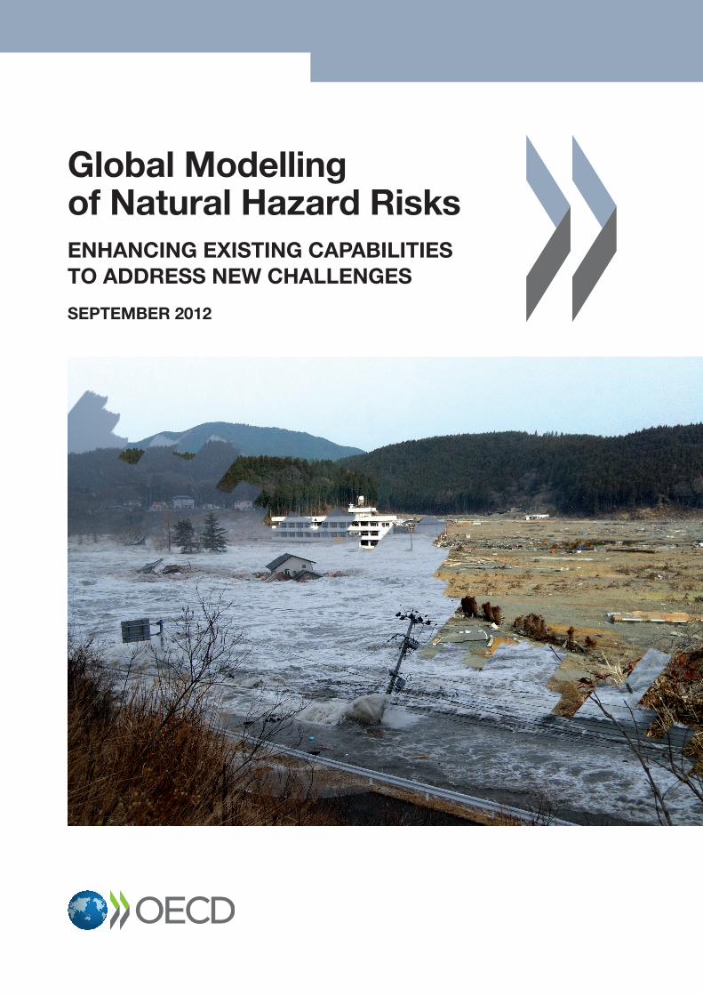
The impact of natural hazards on society around the world has increased dramatically in recent years. Large catastrophic events, such as the 2010 Haiti earthquake and major flooding in Pakistan or the 2011 tsunami in north-eastern Japan have resulted in hundreds of thousands of deaths and record-high economic costs (over USD 350 billion for 2011 alone).
Such large events have highlighted the catastrophic interactions among different natural and technological hazards, causing unprecedented cascading effects, with severe consequences to human populations and the environment. Beyond the 2011 Tohoku tsunami, other recent events such as the 2010 heat wave in Russia, and the eruption of the volcano Eyjafjallajökull in Iceland, have shown how local natural events may have profound consequences not only in neighbouring countries but may also trigger a chain of socio-economic reactions at a global level (on agriculture prices and international air traffic in these cases), and that current models may not be sufficient to accurately inform even developed countries of the impact of such disasters.
This report of the OECD Global Science Forum includes an analysis of the existing gaps in data, knowledge and practices in the field of risk assessment for large and complex disasters. It proposes a series of policy recommendations aimed at improving international co-operation in two major areas:
• Assessing and modelling the risk of large scale domino/cascading effects caused by natural hazards interacting with technological risks;
• Developing international standards, methodologies and tools for use at the local level, enabling consistency and interoperability of data and models.
Global Modelling of Natural Hazard RisksENHaNciNG ExistiNG capabilitiEs to addREss NEw cHallENGEs
sEptEMbER 2012
www.oecd.org/sti/gsf
Front cover: Tokura Elementary School, Minami-Sanrikucho, Miyagi Prefecture, Japan, during and after the tsunami. © Atsushi Asokawa, Seiichi Suto, Hideyuki Katakai
002012321cov_A4_OK.indd 1 08/10/2012 09:38:52
Page 1 of 24
Organisation for Economic Co-operation and Development (OECD) Global Science Forum
Global Modelling of Natural Hazard Risks:
Enhancing Existing Capabilities to Address New Challenges
September 2012 Contents page
1 Rationale and Background 2
2 Findings 6
2.1 There is a strong demand for data mining, data harmonisation and data standards 6
2.2 Vulnerability and exposure are critical elements for effective risk assessment 7
2.3 Effective multi-risk/multi-hazard assessment models are still in their infancy 8
2.4 Potential cascading/domino effects in natural and man-made systems are very rarely taken into account 9
3 Conclusions and Policy Recommendations 11
Annex 1. Survey Findings 14
Annex 2. List of Participants (Brussels Workshop, 9-10 February 2012) 23
Page 2 of 24
1. Rationale and Background
Rationale According to many organisations, 2011 is the year with the highest catastrophe-related economic losses in history, reaching an estimated USD 380 billion1 and costing insurers approximately USD 116 billion2. The biggest losses came from the magnitude 9.0 Tohoku Earthquake in Japan and the magnitude 6.3 Christchurch Earthquake in New Zealand, with USD 250-300 billion and USD 18 billion in estimated losses respectively. In addition, severe flooding in Thailand (USD 12 billion) and Australia (USD 1.8 billion) triggered above USD 13 billion in insurance claims. Two massive tornado events in the United States caused nearly USD 14 billion in claims and the loss of more than 400 lives. Hurricane Irene cost industry nearly USD 5 billion in property damage. Technological-related disasters such as the 2010 BP Gulf drill rig disaster are also contributing increasingly to ever higher economic impacts.
Beyond the economic losses, the Tohoku Earthquake has highlighted the catastrophic interactions among different natural and technological hazards, causing unprecedented cascading effects, with severe consequences to human lives and the environment. Other recent events such as the 2010 heat wave in Russia, and the eruption of the volcano Eyjafjallajökull in Iceland, have shown how local natural events may have profound consequences not only on neighbouring countries but may also trigger a chain of socio-economic reactions at a global level, and that current models may not be sufficient to accurately inform even developed countries of the impact of such disasters.
The devastating effect that natural and manmade hazards have on societies around the world is particularly relevant in developing regions, where countries are experiencing rapid population growth and intense urbanisation but where, for many areas at risk, hazard, vulnerability and exposure maps are often inadequate, unavailable or inaccessible. In 2010, the Haiti earthquake and flooding in Pakistan alone accounted for about 300 000 deaths and over a million homeless people. The lack of adequate information for disaster response was so profound that it triggered a global collaborative effort to develop exposure information via the worldwide web using remotely sensed imagery.
In recognition of the growing threat from natural disasters, a number of international organisations and initiatives have been set up to promote and develop risk awareness and assessment. The UN International Strategy for Disaster Reduction (ISDR) was established in 1999, and, in the wake of the 2004 Indian Ocean Earthquake and Tsunami, led the development of the 2005 UN Hyogo Framework for Action3. Other international initiatives such as the UN Global Risk Identification Programme (GRIP) and the World Bank Global Facility for Disaster Reduction and Recovery (GFDRR) were also created in response to the Hyogo Framework. In parallel, regional initiatives such as those fostered by the EU Commission on Risk Assessment and Mapping Guidelines for Disaster Management emphasise the need for a risk management
1 www.munichre.com/en/media_relations/press_releases/2012/2012_01_04_press_release.aspx 2 Swiss Re (2012): Sigma, Natural Catastrophes and Man-made Disasters in 2011: Historic losses surface from record
earthquakes and floods, No. 2/2012. 3 Hyogo Declaration: www.unisdr.org/wcdr
Page 3 of 24
framework that includes multinational collaboration in hazard and risk identification and analysis, impact analysis, risk assessments and matrices, scenario development and risk management measures. Such initiatives, complemented by better mechanisms to engage governments, communities and the private sector are needed in order to implement risk reduction measures, within the framework of better risk management. The conclusions derived from observations of risk assessment practice internationally are:
• commonly used methodologies and input data vary widely in format and quality, making it difficult to compare results across national boundaries or across hazards and risks;
• current initiatives do not always make clear what the primary, underlying causes of risk are, whether stemming from hazard severity or frequency, the vulnerability of the building stock, or lack of recovery capability;
• reliable information on existing infrastructure (e.g. buildings, lifelines and emergency response capability) is often missing or incomplete. A few examples of national exposure databases of buildings and infrastructure exist, such as in Turkey, Australia, and New Zealand, but at the global level, only population data have been aggregated (e.g. LandScan4);
• beyond the measurement of direct physical and monetary losses, the broader and indirect socio-economic impacts of natural hazards are poorly understood and rarely modelled, while the integrated assessment of the social and economic impacts of disasters is key to support risk mitigation;
• strategic decision-making by governments, international bodies and (large) companies requires not only transparent, uniform and global risk information, but also consensus and community ownership, thus calling for a worldwide involvement in the development and application of risk modelling.
The need for better risk assessment data and tools therefore remains high. Indeed global disaster risk management has been included in the 2012 G20 priorities, which recognise “the value of Disaster Risk Management (DRM) tools and strategies to better prevent disasters, protect populations and assets, and financially manage their economic impacts” and acknowledge “the need to expand their use”.
4 www.ornl.gov/sci/landscan
Page 4 of 24
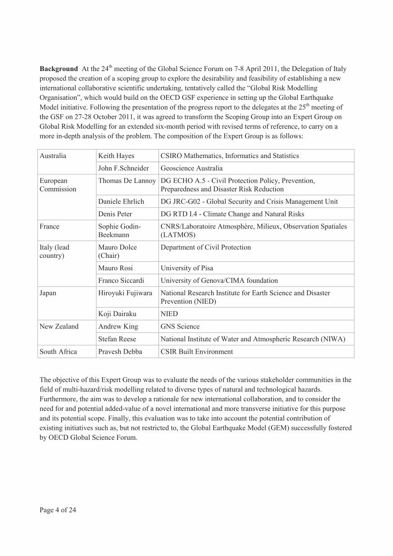
Background At the 24th meeting of the Global Science Forum on 7-8 April 2011, the Delegation of Italy proposed the creation of a scoping group to explore the desirability and feasibility of establishing a new international collaborative scientific undertaking, tentatively called the “Global Risk Modelling Organisation”, which would build on the OECD GSF experience in setting up the Global Earthquake Model initiative. Following the presentation of the progress report to the delegates at the 25th meeting of the GSF on 27-28 October 2011, it was agreed to transform the Scoping Group into an Expert Group on Global Risk Modelling for an extended six-month period with revised terms of reference, to carry on a more in-depth analysis of the problem. The composition of the Expert Group is as follows:
Australia Keith Hayes CSIRO Mathematics, Informatics and Statistics
John F.Schneider Geoscience Australia
European Commission
Thomas De Lannoy DG ECHO A.5 - Civil Protection Policy, Prevention, Preparedness and Disaster Risk Reduction
Daniele Ehrlich DG JRC-G02 - Global Security and Crisis Management Unit
Denis Peter DG RTD I.4 - Climate Change and Natural Risks
France Sophie Godin-Beekmann
CNRS/Laboratoire Atmosphère, Milieux, Observation Spatiales (LATMOS)
Italy (lead country)
Mauro Dolce (Chair)
Department of Civil Protection
Mauro Rosi University of Pisa
Franco Siccardi University of Genova/CIMA foundation
Japan Hiroyuki Fujiwara National Research Institute for Earth Science and Disaster Prevention (NIED)
Koji Dairaku NIED
New Zealand Andrew King GNS Science
Stefan Reese National Institute of Water and Atmospheric Research (NIWA)
South Africa Pravesh Debba CSIR Built Environment
The objective of this Expert Group was to evaluate the needs of the various stakeholder communities in the field of multi-hazard/risk modelling related to diverse types of natural and technological hazards. Furthermore, the aim was to develop a rationale for new international collaboration, and to consider the need for and potential added-value of a novel international and more transverse initiative for this purpose and its potential scope. Finally, this evaluation was to take into account the potential contribution of existing initiatives such as, but not restricted to, the Global Earthquake Model (GEM) successfully fostered by OECD Global Science Forum.
Page 5 of 24
In an initial phase, the Expert Group reviewed, with the input from a consultant, Marit Undseth, the current landscape of existing national and international risk assessment/risk modelling projects. It also examined the GEM initiative, analysing both its operative model as well as the specificity/transferability of GEM tools to other (non-earthquake related) risks. In a second phase, a follow-up survey on existing work and initiatives in the area of global/multi-risk assessment was conducted by the consultant, with feedback from the various stakeholder communities and institutions. The results of this survey (Annex 1) were used as a basis for discussion with the stakeholder community during a workshop hosted by the European Commission in Brussels on 9-10 February 2012. The objective of this workshop, which brought together 37 participants from 23 countries, international organisations and private companies (Annex 2), was to review and agree on the existing gaps and demands from both the scientific and user communities in the field of global multi-hazard/risk modelling.
Page 6 of 24
2. Findings
This study could not fully assess all current activities in the field of risk assessment, nor investigate in detail the needs and expectations of all potential stakeholders. User groups are highly diverse and modelling and data needs differ accordingly. These limitations notwithstanding, the results obtained from the consultant survey and the Brussels workshop led to the identification of a series of consensus issues described in the following paragraphs.
2.1 There is a strong demand for data mining, data harmonisation and data standards
The majority of respondents to the survey as well as the participants at the workshop reported that the availability of most types of data was poor in several areas of the world (mainly in developing countries), and that the temporal and spatial scale of the data were limited. Furthermore, the quality of data was inconsistent, due to the lack of international standard, and the different skills and resources available to the agencies responsible for data collection and management. Inconsistent data quality and quantity undermines global comparisons of risk model outputs because the model is likely to be inaccurately parameterised for regions with poor data quality and sparse data sets.
More generally, there appears to be a need to develop and share best practices, guidelines, methodologies and standards to ensure consistent data and tools are available and to increase skills at the national and local levels, thus combining bottom-up and top-down approaches. Current international data harmonisation and standardisation initiatives, such as the Integrated Research on Disaster Risk (IRDR) or the International Disaster Database EM-DAT5 only cover very partially the needs of the risk assessment community. An example of an ambitious data collection project is that of the Global Earthquake Model (GEM)6, which in co-operation with local and national institutions, is developing computational tools together with a global database of earthquake events, losses and exposure data, with a spatial scale relevant both for local, national and global level analysis. The architecture of the tools and the database allows for the inclusion of data and analytical models relevant to hazards other than earthquakes.
The privacy status of (sensitive) vulnerability and exposure data can be an obstacle to modelling
Efforts should be made to improve or create access to existing data. Vulnerability and exposure data of private corporations on critical infrastructure are often inaccessible due to security or commercial reasons. Nevertheless, they play an essential part in risk modelling, and the need for such data was highlighted by the majority of survey participants and at the workshop.
Building a global database in this area appears to be a very challenging task. To circumvent the problem, data could be presented as aggregates or metadata, and more sensitive data only introduced in models for calculations by the owner with specific restrictions, without providing a general access to all users.
5 For further information on IRDR: www.irdrinternational.org/about-irdr/scientific-committee/working-
group/disaster-loss-data; for information on EMDAT: www.emdat.be. 6 www.globalquakemodel.org
Page 7 of 24
Single risk assessment methods, databases and outputs should be harmonised
Hazards have different impact areas and return periods: for instance, temporal and spatial scales for earthquakes differ from those for landslides or floods, as does the type of data that is required for parameterisation and calibration of risk models. Risk assessment for an area exposed to multiple hazards requires solutions to compare the risks in a probabilistic way and plan accordingly, whenever possible. Risk assessment models that take into account several hazards at the same time, and thus include a certain degree of harmonisation, exist both in the public and the private sector, but there are no international standards for harmonisation that could allow some interoperability between models. Such harmonisation, which should include a consensus agreement on a minimum standard for a risk assessment methodology, could therefore help for the comparison of different risks and the evaluation of risk interactions, as well as allowing for better exchange and use of data across frontiers.
2.2 Vulnerability and exposure are critical elements for effective risk assessment
There has been a general shift of focus in risk modelling away from hazard impacts towards the determination and calculation of risk, which incorporates information on vulnerability and exposure.
Quantifying exposure - the compilation of the element at risk such as roads, buildings, population, societal functions, the economic system, the traditional and the cultural heritage - is challenging because it is made up of many interactive elements and also because there is no organised “exposure” community, as there is for various hazards, that specifically focuses on exposure.
Vulnerability - the extent to which an element at risk can withstand the impact of the hazard - is even more difficult to quantify. The concept of vulnerabilities may change according to the element at risk that are taken into consideration to estimate exposure. For example, the vulnerability of the economic system will be different and measured differently from that of the building stock. Vulnerabilities of the elements at risk may change over time, during the disaster cycle, and also if faced with multiple coinciding events (time-dependency issues). Quantitative vulnerability data are available only to a limited extent, and only for certain elements at risk such as physical vulnerabilities for the building stock or specific infrastructures, or vulnerabilities of an economic system. There is a real demand to include elements such as resilience or social vulnerability in risk assessments. Very few tools to measure resilience exist at present, notwithstanding the fact that there is not an internationally accepted definition of resilience. The new EU Embrace Project (www.embrace-eu.org), which aims to clarify, characterise and define the resilience capacity of a society in the context of disasters in Europe, may provide interesting results of future efforts in this area.
With the overall aim of increasing communities’ resilience and avoiding, lessening or transferring the adverse effects of hazards, it is important to embed risk assessment in an overarching concept, e.g. that of a (disaster) risk management framework. The assessment process needs to be connected to the policy question that has to be answered or what kind of decision is expected to be made, and how important and tolerable the risk to individuals and communities may be.
Page 8 of 24
The scarcity and inconsistencies of vulnerability information often makes it the weakest link in a risk assessment. While it may be argued that some aspects of vulnerability are not directly or readily quantifiable, more efforts should be made to identify and develop proxy measures, to reduce uncertainties and to consider time-dependency in order to improve assessments.
In terms of methodology, the uncertainties involved in risk assessment make a case, according to many participants, for the extended use of probabilistic assessments. However, efforts must also be made to reduce the knowledge (or epistemic) uncertainty, and better characterise real-world variability associated with the model structure and parameters of risk models, especially fragility curves, which are characterised as the weakest link in the chain of risk assessments. High levels of uncertainty are, however, not specific only to vulnerability issues, but also affect hazard assessment. In climate change research, for example, it is very difficult to make any reasonable predictions about non-stationary hazards beyond a 20-30 year time frame.
The accuracy of a risk assessment model is highly dependent on the data used to parameterise it and the expert knowledge used to create it. The Tohoku accident is sometimes used as an example to show the limits of probabilistic risk assessments. The real issue is not an inherent weakness in the probabilistic method, but rather in human ability to characterise fully the uncertainty, or lack of knowledge, of potential events in the future. All possible event scenarios (so-called deterministic events), whether based on historical, geological or hypothetical future extreme events, need to be considered and captured as part of any probabilistic risk assessment. Moreover, where the consequences of an event can be catastrophic, any decision to accept some level risk, rather than to eliminate it, must be done in accordance with international standards for technical rigour.
2.3 Effective multi-risk/multi-hazard assessment models are still in their infancy
Multi-hazard tools are currently in different stages of development. A number of publicly developed tools exist (Central America Probabilistic Risk Assessment - CAPRA, Riskscape in New Zealand, HAZUS-MH in the United States)7, for which a certain amount of harmonisation has been carried out, allowing for some comparability between hazards. However, these models very rarely delve into the temporal, spatial or causal relationships that frequently occur between hazards, nor take into account the time-dependency or dynamic nature of vulnerability. From a vulnerability research point of view, vulnerability indexes exist, such as the World Risk Index8, which take into account different types of vulnerability and their change over time. However, they do not take into account interactions between hazards. Consistency of methodologies and common database standards are also necessary elements to allow for risk comparison. The EU research programme MATRIX (New Multi-Hazard and Multi-Risk Assessment Methods for Europe) is looking for probabilistic solutions to some of these questions, but is not expected to create any practical applications in the immediate future9.
7 For further information on HAZUS-MH: www.fema.gov/plan/prevent/hazus/; Riskscape: www.riskscape.org.nz/;
CAPRA: http://gfdrr.org/docs/Snapshot_CAPRA.pdf. 8 For further information, see World Risk Report; UNU-EHS, 2011. 9 http://matrix.gpi.kit.edu/downloads/Fact-sheet-matrix-general.pdf.
Page 9 of 24
No consensus was found for the development of more sophisticated multi-hazard or multi-risk assessment models during the working group’s deliberations and survey. In practice, what may be more fundamentally important is to assure the veracity and completeness of the data feeding into the models, and to have means of evaluating or certifying the skills of the persons carrying out the assessments. The development and dissemination of harmonised international data and analysis standards or guidelines would help in this regard. There are also doubts whether global solutions could solve local problems, but again the current heterogeneity of structures and processes is not helping the development of coherent mitigation policies. Future multi-risk assessment tools should involve the local/user communities in a participatory mechanism. The general perspective, however, is that there are advantages in combining the strengths of local to global contributions. For instance, the international/global domain is best suited to developing consensus methodologies and associated standards, developing algorithms and scientific knowledge into analytical tools, and to aggregating/integrating global data into information systems. On the other hand, the local community is ultimately the source of the detailed data needed to populate data systems, and must be a party to validating analytical tools, as well as to shaping them into user-friendly applications. Ultimately, if the local community is not involved in the development process it will not trust (or use) the end product.
2.4 Potential cascading/domino effects in natural and man-made systems are very rarely taken into account
Understanding cascading/domino effects was clearly identified as an important need by many users and requires not only specific modelling tools but also close interaction/co-operation between different fields of risk research.
There was a general consensus among those canvassed by the Working Group that vulnerability to disasters is growing, due to increasing economic and industrial interdependence. Ageing infrastructure, urbanisation, increasing economic pressure, and also higher dependence on technology may also add to vulnerability. All these factors lead to the belief that technological disasters triggered by natural hazards may happen more frequently in the future.
Furthermore, a global assessment of the risks associated with potential trans-boundary events, such as electric power cut failures, nuclear plant accidents, or large oil spills, would benefit from development of international risk assessment methodologies and standards in order to facilitate comparisons of the cascading risks associated with the impacts of natural hazards on these types of facilities across the globe. Attempts to harmonise and compare risk assessments for these facilities across the globe, however, may be frustrated because, data on plant failure rates, for example, are often proprietary and considered commercially in confidence. Some datasets exist in various national or international organisations (such as from the International Atomic Energy Agency, or on waste storage facilities in many countries) but security considerations are a restricting factor for their appropriate use in global risk assessment. Standardised methodologies for cascading/domino probabilistic risk assessment and globally accessible data sets could help countries take into account technological risk triggered or amplified by natural events. There is also a demand for standardised data collection of technological disasters triggered by natural events, in order to build a database of such events which so far exists mostly for fires following earthquakes.
Page 10 of 24
The most fundamental and important step is first to identify a priori critical points where accidents may trigger domino effects. In fact, while it may be unfeasible from a physical point of view to model realistically the details of the impact of a highly nonlinear system (as large-scale cascade events are), an important first step would be not only to identify where catastrophic failures have originated in the past, but even more where they are most likely to occur in the future. Reducing the risks at these critical points would result in a substantial reduction of the overall risk at worldwide scale. In addition, we should continue to develop analytical approaches for understanding critical points of failure and complex system behaviour, which will allow us to systematically progress to better understanding of risks (probability and consequences), and thereby inform efforts to mitigate previously unforeseen risks.
Taking into account cascading effects, which can lead to a dramatic amplification at a global level of more local natural events, would therefore emphasise the identification of critical points (not all points are able to trigger large scale cascade effects), develop priorities for better modelling and risk assessment, with the ultimate objective of mitigating extreme consequences in a pragmatic and economically viable way.
Page 11 of 24
3. Conclusion and recommendations
When investigating the need for more international modelling efforts, one of the challenges of any global initiative is that of inconsistency between top-down advice or recommendations from international authorities or organisations and more bottom-up information from, for instance, local communities or stakeholders. Involving the general public as stakeholders in the process may also complicate the final outputs. Therefore, any new global initiative would likely have a best added value if focused on global/multi-national impacts of disasters, as single countries may not easily address global-scale problems. This initiative should be informed by data and experience gained at the local, national and regional levels as much as possible.
The findings of the Expert Group can be summarised as follows:
1. Natural hazard and multi-hazard risks are being addressed by a number of institutions, nationally and internationally, and there is thus a clear demand to generate, and make accessible, global risk-relevant datasets.
2. In many countries of the developing world, however, risk assessment is still a new concept and governments often do not have the institutional structures or governance mechanisms to effectively manage risks. Multilateral institutions such as the UN ISDR, together with many regional (such as those set up by the EU) and government aid programmes that link development aid to disaster risk assessment/management are committed to improving this situation.
3. Those governments that do address risk most effectively agree on the need to have a multi-hazard risk assessment approach that can also address the potential for cascading effects and interactions between natural hazards and technological hazards. However, the capability to address multi-hazard risk problems and cascading effects across systems and communities and from local to international scale are only just starting to be developed.
4. Trans-boundary issues are becoming increasingly important but have only recently started to be seriously addressed.
5. At the technical level, standards tools and methodologies - even definitions - have yet to mature to a stage where they can be used and endorsed internationally.
6. Similarly, datasets and analysis tools used to measure risk - including those related to exposure and vulnerability - are often not available; the GEM initiative - which is centred on the earthquake community - could be taken as a model for building better standardised databases and user-friendly assessment tools.
Considerable efforts are being conducted by a large diversity of public, private and international organisations to provide better risk evaluation and mitigation of, or reaction to, natural and manmade disasters. Nevertheless, following a gap analysis of the existing risk assessment databases, tools, methodologies, models and initiatives from the various stakeholders and discussions with stakeholder communities, the Expert Group considers that a new international initiative could bring considerable benefit to existing efforts by addressing currently poorly understood phenomena and providing better information and data for the risk communities.
Page 12 of 24
The Expert Group therefore recommends:
1. To initiate an international consultation between interested stakeholders for setting up an international platform/resource on risk assessment of large-scale events that cannot be addressed by single countries (or that may have an impact beyond a single country), taking into account the potential for large scale domino/cascading effects caused by natural hazards interacting with technological risks.
The necessity to tackle large-scale events with trans-boundary consequences of natural or technological origin, or both, was emphasised in the survey and in the workshop. Inconsistent, sparse or otherwise inaccessible datasets, coupled with inconsistent or non-existent methods for probabilistic multi-hazard risk assessment currently prevent meaningful global comparisons of these types of risks. Furthermore, there is little knowledge of exposure and physical/functional vulnerability to these hazards that would help identify multi-hazard risk scenarios, and the cascading effects associated with these scenarios, that can lead to a dramatic amplification at a global level of more local natural events. This type of knowledge would help to identify critical points (not all points are able to trigger large scale cascade effects), which could then help to mitigate extreme consequences in a pragmatic and economically viable way. There are many risk hotspots in the world but little is known about specific vulnerabilities of large infrastructure or economic networks to natural and technological hazards. There is also a problem of scale and format. Existing data are usually only available at local or national level, which does not allow for trans-boundary coverage and makes it difficult to model high-impact risks that affect entire regions.
At the same time, global economic and social vulnerability to disasters is growing. Economic and industrial interdependence is increasing; critical infrastructures are ageing; the population and industrialisation are rising in areas exposed to multiple natural hazards; and increasing economic pressures make every link in the chain less flexible and more prone to failure. All these factors make it likely that high-impact disasters may happen more frequently in the future. Moreover, with much of the data lacking or classified, there exists little foundation for understanding the economic and practical risks of a prolonged or cascading crisis.
The Expert Group recommends that further investigation on the possible objectives, governance structure, funding mechanism and programme of work of such an international initiative be conducted by interested governments, together with other stakeholders such as international organisations, and public and private institutions, under the auspices of an international structure such as the OECD Global Science Forum.
2. To develop international standards, methodologies and tools for use at the local level, enabling consistency and interoperability of data and models.
At present, numerous local, national, international, public and private actors invest considerable effort and resources in the collection and processing of risk data, using formats and methodologies that are not interoperable. Significant gains could be made by creating international standards and tools in the area of disaster risk management, thus facilitating the improved comparison of risks, improving co-operation between the different risk research communities as well as lowering costs and adding simplicity at the local level.
Page 13 of 24
Standards should be created in a way that allows for inter-operability of data and analyses between different hazards and associated datasets, thus surpassing the currently existing barriers of scales and format. Equally, standards must be developed for hazard/vulnerability/risk models, maps and methodologies and other tools used at both the local, national and international level. Furthermore, mechanisms should be developed to enable a transfer of state-of-the-art research and knowledge to local user communities across the globe.
The Expert Group recommends that such a new international platform should adopt a collaborative and consensus-building approach, similar to the approach proposed by the GEM initiative, and building on the GEM experience, to ensure buy-in from the various user communities. It should build upon the existing initiatives, avoiding duplication or overlapping but rather maximising their impact by introducing/improving mechanisms for interaction and sharing of data, methods, tools and standards. The GEM initiative offers some interesting features for addressing multi-hazard risk assessment needs:
• It was designed from the start as an international community effort, bringing together the various earthquake risk communities for maximising synergies. It also provides a good example of the diversity of users’ interests, and the need to consider users as partners from the start.
• It is developing various tools that have potential multi-hazard risk features/capacities, and in particular global exposure databases (on buildings, people, and economic vulnerability), which could be developed to respond to the needs of other risk communities. Also of interest is the development of tools that allow the continuous population of these databases (remote sensing, crowd sourcing, etc.), and of an open-source software platform (OpenQuake) which is modular and allows the running of risk analyses and calculations.
To facilitate data and experience-sharing worldwide, the Expert Group recommends that further discussion be developed between stakeholders in close co-operation with UN structures such as the UN ISDR (International Strategy for Disaster Reduction).
Page 14 of 24
Annex 1. Survey Findings
Marit Undseth (Consultant)
Contents page
1 Background 15
2 Summary of Findings 15
2.1 Natural and technological hazard mapping 16
2.2 Mapping of exposure and vulnerability of assets to natural and technological hazards 17
2.3 Risk assessment practices 18
2.4 International/interdisciplinary co-operation needs 19
2.5 Survey among international organisations and NGOs 20
3 Tentative conclusions 21
4 Contributing organisations 22
Page 15 of 24
1. Background
The Global Science Forum of the OECD launched in November 2011 an Expert Group on Global Risk Modelling to evaluate the rationale for a new international collaboration in the field of multi-hazard/risk modelling related to diverse types of natural and technological hazards. This collaboration would focus on the relationships between multiple hazards; the way they interact, how they can be compared, and how existing knowledge can be better employed to create a more holistic view of the hazards our society is facing.
To carry out its activity, the GSF Expert Group needed a good overview of the current landscape of risk assessment tools and needs. A survey was undertaken among risk practitioners to identify potential needs related to the questions of risk modelling and tools, international co-operation and database issues. The findings are summarised below.
The survey consisted of three questionnaires directed to business and academic users; to international organisations; and to national disaster management agencies. In some instances, follow-up interviews were carried out over the phone.
The main focus areas were:
• Data acquisition and harmonisation for natural and technological hazards (e.g. data exchange, harmonisation of standards, data acquisition technology)
• Development of tools (e.g. databases, risk assessment models, information platforms)
• Improved international co-operation and communication structures, etc.
The respondents were asked only to take into account natural and technological hazards as defined by UN ISDR10. Food and health-related hazards, as well as man-made hazards, were left out.
2. Summary of findings
There were 23 responses to the survey; three from national disaster management agencies; 13 from academic and professional risk experts; and seven from international organisations, intergovernmental organisations and non-governmental organisations. In the group of academic and professional risk experts four respondents had an insurance background; four had a geohazard background; four had a social and environmental research background; and one provided risk modelling services. In terms of geographical distribution, ten responses were from Europe, one from North America, one from Latin America, five from
10 Natural hazard: Natural process or phenomenon that may cause loss of life, injury or other health impacts, property
damage, loss of livelihoods and services, social and economic disruption, or environmental damage.
Technological hazard: Hazard originating from technological or industrial conditions, including accidents, dangerous procedures, infrastructure failures or specific human activities, that may cause loss of life, injury, illness or other health impacts, property damage, loss of livelihoods and services, social and economic disruption, or environmental damage.
Page 16 of 24
Asia, three from Australia/Oceania, and three from international organisations giving responses based on global activity in developing countries.
The three questionnaires (questions differing slightly according to the target group) aimed to cover the following topics: natural and technological hazard mapping; mapping of exposure and vulnerability of assets to natural and technological hazards; risk assessment practices; and international/interdisciplinary co-operation needs. The questions posed to national disaster management agencies and the academic/professional community where similar, with a focus on data collection and risk assessment practices, while the questionnaire to NGOs and international organisations was more policy-oriented. The replies to this last questionnaire will be presented apart.
2.1 Natural and technological hazard mapping
The questions in the first section focused on the availability and quality of data for natural and technological hazards that the respondents considered the most significant. Where relevant, the respondents were asked to describe how and by whom data was collected and updated, and whether there were any problem areas.
National disaster management agencies:
Respondents among national disaster management agencies described national practices for hazard data collection and maintenance. While subject to variation, all respondents indicated that raw data were collected by different organisations and across different jurisdictions (local, regional, national). In one instance, data was processed and maintained by specific competence centres belonging to the national department responsible for disaster management. In the other two cases; databases had different owners.
Although all respondents had access to high-resolution hazard data, the detail and quality of data varied according to the hazard. One respondent stated that it was difficult to obtain reliable data for determining site-specific risk for tsunami, earthquake and volcanic hazards. Another respondent reported difficulty in obtaining technological hazard data. Otherwise they were of the opinion that the quality and resolution of the natural hazard data roughly matched the risk landscape. It was, however, a concern that the elevated number of collecting agencies and data owners could sometimes affect the quality and consistency of the data.
Business/academic users:
Respondents generally found that there was a strong need for more hazard data, for most types of hazards, in particular hydrological hazards (floods, storm surges, tsunamis) and volcanic hazards, as well as landslides. Although drought was not considered within the scope of the survey, several respondents highlighted the socio-economic importance of drought hazard in many parts of the world, and the difficulty that is involved in modelling drought risk.
Technological hazards were found to be less documented than natural hazards, in part due to privacy issues, but also because there is still much unknown about the interaction between natural and technological hazards.
Page 17 of 24
The geographic differences in data availability were underlined, with Africa, Central and South-East Asia identified as regions were hazard data availability and access are relatively poor.
Respondents were strongly in favour of measures to harmonise and standardise hazard data. In most countries, different organisations and geographical entities were responsible for the collection and maintenance of data, which in many instances led to inconsistencies. There were no measures in place to harmonise data for different types of hazards.
Respondents frequently highlighted the difficulty of accessing data. This could be a conflict ensuing from national or private ownership, but some respondents also described situations where national institutions were unwilling or unable to share data among themselves. The problem of data access was more pronounced in developing countries than in the developed world.
It was furthermore found that trans-boundary (high-resolution) hazard data was generally lacking, although many hazards have impact areas that extend national territories. Many respondents found that such data would be highly useful.
2.2 Mapping of exposure and vulnerability of assets to natural and technological hazards
The questions in the second section focused on the availability and quality of data for mapping exposure and vulnerability of assets to natural and technological hazards. Where relevant, the respondents were asked to describe how and by whom data was collected and updated, and whether there were any problem areas.
National disaster management agencies:
As in section 1, the collection of exposure and vulnerability data was carried out by different organisations, and processed either by the collecting agency (two responses) or by government competence centres (one response). Human habitation data were available at municipality or sub-municipality level. Data related to exposure and physical vulnerability of the built environment were less complete, and again, spread across different jurisdictions, as well as both the private and the public sector. One respondent found that is was sometimes difficult to obtain physical vulnerability data from privately owned infrastructure and installations. Otherwise, vulnerability data were obtained by extrapolating relevant municipal or regional data to the national level.
Business/academic users/vendors:
Respondents reported a scarcity of data for exposure and vulnerability of assets to natural and technological hazards. Physical exposure data tended to have lower than desired resolution (building foot print or even finer resolution desirable for some uses), but much of this information is privately owned, and/or cannot be released for security reasons or economic concerns. The same applied to data related to physical or functional vulnerability of industrial installations and critical infrastructure. One respondent emphasised the problems involved in collecting exposure and vulnerability data from the private sector due to security concerns and suggested that there need be international standards and guidelines that define which data is available to whom. Exposure and vulnerability to volcanic hazards were highlighted as a relatively poorly documented area.
Page 18 of 24
Vulnerability data, in particular the data emanating from social sciences, was found not to have the appropriate format to feed into risk assessments, in the sense that much of the data is not quantitative. Disaster risk research has traditionally been more focused on hazards, and vulnerability research is a relatively recent field. There is still much to discover about human behaviour in the different phases of disaster, as well as the impact of social factors on disaster prevention and resilience. Not all of this research is necessarily quantifiable, but the respondents expressed an urgent need for more research and data in this field, in particular related to physical, social and economic vulnerability.
2.3 Risk assessment practices
In the third section respondents were asked if and how they carried out risk assessments, which methodologies they used, whether they carried out assessments for multiple risks and whether they were satisfied with existing tools.
National disaster management agencies:
All respondents reported that they carried out risk assessments, but there was divergence as to how and when these were carried out. Two respondents had all-hazard national risk assessment schemes in place, taking into account all types of hazards to which the national territory was exposed. In one case, these were carried out at regular intervals (the objective was every four years), while in the other case, it was linked to the national planning process. The methods were mainly qualitative, with quantitative aspects (scoring schemes), which allowed to a certain extent the quantification and comparison of risks (one respondent found this difficult, while the other respondent expressed satisfaction with their current ability). Probabilistic methods were only to a very limited extent, if at all, included in this national risk assessment process.
Two respondents reported using probabilistic risk assessment methods for natural hazards. One had developed a multiple-risk assessment tool, while the other could only assess seismic risk in a full probabilistic way (evaluation of full annual loss rates), and to a more limited degree, volcanic risk.
There was mixed interest for the external development of a multiple-risk tool. One respondent expressed a strong need for such a tool, for national and sub-national use. Another respondent found that probabilistic tools had very limited applicability, which findings were difficult to integrate into the decision-making process (too complicated to use, data issues). The third respondent, whose country already possessed a multiple-risk tool, observed that the nature and quality of the risk models were not the main issue, but rather the decentralised and fragmented collection of data (see section 1 and 2) and the ensuing loss in quality of data feeding into the models.
However, all respondents found that current tools could be improved and that it would be useful to develop a capacity to calculate secondary effects of natural hazards on critical infrastructures and industrial installations, as well as improving the capacity to study the interaction between hazards.
Page 19 of 24
Business/academic users/vendors:
Business and academic respondents used a wide range of different risk assessment methodologies in their research and work, either industry-developed or in-house. Respondents from the insurance industry and risk modelling industry reported having the ability to take into account technological risks, also in a probabilistic way.
The majority of respondents expressed dissatisfaction with the range of tools currently available. First, several respondents wanted a transparent, open-source, probabilistic multiple hazard model, with universal applicability, something which does not exist today. Models currently used have different origins (developed by vendors, national agencies or academic groups). There is no harmonisation of data, standards or methodology, the data and model outputs are often proprietary.
Second, some respondents found that current models were too reliant on data, with not enough scientific input. There was furthermore an issue of how to best take account of the inherent uncertainty of these models. Problems may occur in situations where there is not enough spatial or temporal data, typically for high-impact/low-probability events for which there tends to be little historic data – the same problem may arise for earthquakes. Equally, minor events are inclined to be underreported. The usage of wrong data may also lead to skewed results. It was stated that the risk modelling industry was in need of innovation and research, and that deterministic skills somehow needed to be integrated into the probabilistic approach.
Third, most respondents found that the capacity to calculate losses needed improvement, especially secondary and contingent losses, which are playing an increasing part of overall disaster losses.
2.4 International/interdisciplinary co-operation needs
The questions in the fourth and last section tried to identify whether the respondents were satisfied with current structures for co-operation and information exchange.
National disaster management agencies:
Two of three respondents had only a limited need for more international co-operation in the area of risk assessments. They found that the national platforms for disaster risk management were functioning to a satisfactory degree and that they had access to the networks they needed. One respondent had established a national interdisciplinary platform (including the private sector, infrastructure owners, etc) that participated in the national disaster risk planning. Nevertheless, all respondents found that they could need more information on trans-boundary hazards (nuclear spills, volcanic ash, etc). Time was found to be limited and it was largely a question of available resources to engage in more international co-operation.
Business/academic users/service providers:
Eight of twelve respondents expressed dissatisfaction with the existing level of international co-operation. Three participants (with an insurance background) were in favour of the development of some kind of internationally endorsed hazard model, covering all main hazards (flood especially). One respondent was deeply unsatisfied with most current structures which demanded too much one-by-one efforts from their side and would favour a type of co-operation that is transparent and scientific-based, involving
Page 20 of 24
international stakeholders. Two participants wanted much more focus on vulnerability at the international level, one suggesting a yearly updated database. The creation of data exchange initiatives was also recommended.
Several respondents found that they had valuable information on disaster risk management that was not taken into account by policy makers because they were not part of the decision-making process. One respondent also found that disaster prevention was not prioritised by national policy-makers.
Disaster risk management still seems to be the domain of engineers and geoscientists. One respondent from the natural hazard community enquired whether ‘risk’ was fully embedded in their research, or if they were still more focused on hazard assessment and analysis. This was partially confirmed by observations from respondents the insurance industry that more co-operation was needed with academic researchers to strengthen practical applications of hazard research. Furthermore, all respondents called for more co-operation with social sciences.
2.5 Survey among international organisations and NGOs
The questionnaire destined to international organisations and NGOs focused on regional and international co-operation and policy needs related to data exchange and harmonisation, capacity-building, strengthening of institutions as well as other areas in disaster risk management.
The respondents from international organisations and NGOs strongly supported measures for regional and international harmonisation of data and risk assessment tools, as well as for terminology, definitions, hazard and risk maps, resolution, and formats. The majority of respondents also expressed a need for the exchange of data between countries. Respondents reported that the availability of hazard, exposure and vulnerability data, as well as that of openly accessible bathymetry/topography data products and digital elevation models needed to be improved, and that there was a need for trans-boundary, area-covering data.
Furthermore, all participants supported measures to strengthen (national) institutions responsible for data collection and other risk assessment-related activities. There was also a pronounced need for scientific capacity-building at the national level, and it was also noted that the capacities and skills of local communities need to be reinforced.
Among the respondents there were both users of risk assessment methodologies, as well hazard monitoring agencies and providers of development aid and risk management solutions. The three respondents who identified themselves as users employed different types of methodologies, according to the expertise of foreign and in-house consultants, both industry-developed and community-developed. They were strongly in favour of the development of an open-source multi-hazard risk assessment tool, while emphasising that the technology needed to be flexible and adaptable to user needs. One respondent insisted that they needed a tool that could be applied at the local level, of which there were currently very few.
This was also the opinion of respondents from international organisations involved in disaster reduction activities in developing countries. While generally favourable to probabilistic risk assessment methods, several respondents expressed caution as to how such tools could be the most useful. It was noted that any such tool must be adapted to the user in mind. More specifically, all respondents wanted an adaptable tool, with the possibility to switch formats and scales and add or discard functions according to user preferences.
Page 21 of 24
Open-source software was by the vast majority identified as the best solution for this. It was noted that the tool should be targeting users at the national or sub-national level.
Several respondents from international organisations highlighted the overarching importance of skills management and the support and/or creation of sustainable institutions, at both the national and local level. The importance of awareness-raising and the creation of mutually beneficial knowledge networks were also underlined.
3. Tentative conclusions
This was an informal, non-scientific survey, with no pretention of being representative. It was circulated to a limited number of national agencies and organisations, aiming at a certain geographical and disciplinary diversity, which has been fulfilled to a certain extent. Respondents gave their personal views that are not necessarily shared by the organisations they represent. Certain regions, such as the Americas, Central Asia and Africa, are poorly represented. Despite these shortcomings, it seems possible to derive some general findings:
• The work to harmonise data within and across natural hazards needs to be reinforced. This would facilitate the data collection process for single hazard assessments as well as enable a possible comparison of multiple hazards.
• Exposure data tend to be spread across different owners and jurisdictions. When they are collected, information relevant to several hazards is not taken into account.
• Vulnerability data have poor visibility and/or accessibility, for reasons that need to be properly investigated.
• If a risk assessment tool be developed at the international level, it needs to be open-access, flexible and adaptable according to scale and user groups.
• More attention should be paid to social and political factors enabling the use of risk assessments – community ownership, capacity-building, as well as proper instruction into the limits and uncertainties of such assessments.
• Technological hazards ensuing from natural disasters seem to be poorly documented at the national level and even less so at the international level.
• Trans-boundary data for high-impact, low probability disasters, of technological and natural origin, are completely lacking. It is unclear whether existing structures at the international level are taking these hazards into account.
Page 22 of 24
4. Contributing organisations
Organisation Contact person
ADRRN – Asian Disaster Reduction & Response Network
Mihir Joshi
Aon Benfield Russell Blong
Aon Benfield UCL Hazard Centre Ben Wisner
ASEAN Marqueza Lepana Reyes
Asian Disaster Protection Centre Peeranan Towashiraporn
AUEDM Net - Asian University Network of Environment and Disaster Risk Management
Rajib Shaw
Beijing Normal University Peijun Shi
FM Global Louis Gritzo
FLACSO – Latin-American Faculty of Social Sciences
Alan Lavell
GFDRR- Global Facility for Disaster Reduction and Recovery, World Bank
Robert Soden
Global Volcano Model, University of Bristol Stephen Sparks
Helmholtz Centre Potsdam - GFZ German Research Centre for Geosciences
Jochen Zschau
Italian National Department of Civil Protection Mauro Dolce
Kandilli Observatory and Earthquake Research Institute, Bogazici University, Turkey
Mustafa Erdik
New Zealand Ministry of Civil Defence and Emergency Management
Richard Smith
NGI – Norwegian Geotechnical Institute Farrokh Nadim
SOPAC – Secretariat of the Pacific Community, Applied Geoscience and Technology Division
Litea Biukoto
Swiss Federal Office of Civil Protection Stefan Brem
Swiss Re Ulrich Ebel
UNDP, Global Risk Identification Programme Jianping Yan
UNU-EHS – United Nations University, Institute for Environment and Human Security
Joern Birkmann
Willis Research Network Gero Michel
World Meteorological Organisation Maryam Golnaraghi
Page 23 of 24
Annex 2. List of Participants
Brussels Workshop, 9-10 February 2012
Columbia Omar Cardona National University of Colombia
European Commission
Thomas De Lannoy
DG ECHO A.5 - Civil Protection Policy, Prevention, Preparedness and Disaster Risk Reduction
Daniele Ehrlich DG JRC-G02 - Global Security and Crisis Management Unit
Domenico Giardini
ETH Zurich
Denis Peter DG RTD I.4 - Climate Change and Natural Risks
Andrea Tilche Environmental Technology Unit, Research Directorate
FM Global Louis Gritzo VP Research
France Sophie Godin-Beekmann
CNRS/laboratoire Atmosphère, Milieux, Observation Spatiales (LATMOS)
Hormoz Modaressi
BRGM (Bureau de Recherches Géologiques et Minières)
Germany Jochen Zschau GFZ (GeoForschungsZentrum Potsdam)
GEM Sálvano Briceño Global Earthquake Model Foundation
Nicole Keller
Rui Pinho
GEO Francesco Gaetani
Group on Earth Observation
GVM Suzan Loughlin Global Volcano Model/British Geological Survey
IIASA Stefan Hochrainer
International Institute for Applied System Analysis
Page 24 of 24
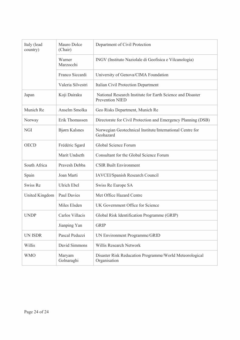
Italy (lead country)
Mauro Dolce (Chair)
Department of Civil Protection
Warner Marzocchi
INGV (Instituto Naziolale di Geofisica e Vilcanologia)
Franco Siccardi University of Genova/CIMA Foundation
Valeria Silvestri Italian Civil Protection Department
Japan Koji Dairaku National Research Institute for Earth Science and Disaster Prevention NIED
Munich Re Anselm Smolka Geo Risks Department, Munich Re
Norway Erik Thomassen Directorate for Civil Protection and Emergency Planning (DSB)
NGI Bjørn Kalsnes Norwegian Geotechnical Institute/International Centre for Geohazard
OECD Frédéric Sgard Global Science Forum
Marit Undseth Consultant for the Global Science Forum
South Africa Pravesh Debba CSIR Built Environment
Spain Joan Marti IAVCEI/Spanish Research Council
Swiss Re Ulrich Ebel Swiss Re Europe SA
United Kingdom Paul Davies Met Office Hazard Centre
Miles Elsden UK Government Office for Science
UNDP Carlos Villacis Global Risk Identification Programme (GRIP)
Jianping Yan GRIP
UN ISDR Pascal Peduzzi UN Environment Programme/GRID
Willis David Simmons Willis Research Network
WMO Maryam Golnaraghi
Disaster Risk Reducation Programme/World Meteorological Organisation
Global Modelling of Natural Hazard RisksENHaNciNG ExistiNG capabilitiEs to addREss NEw cHallENGEs
The impact of natural hazards on society around the world has increased dramatically in recent years. Large catastrophic events, such as the 2010 Haiti earthquake and major flooding in Pakistan or the 2011 tsunami in north-eastern Japan have resulted in hundreds of thousands of deaths and record-high economic costs (over USD 350 billion for 2011 alone).
Such large events have highlighted the catastrophic interactions among different natural and technological hazards, causing unprecedented cascading effects, with severe consequences to human populations and the environment. Beyond the 2011 Tohoku tsunami, other recent events such as the 2010 heat wave in Russia, and the eruption of the volcano Eyjafjallajökull in Iceland, have shown how local natural events may have profound consequences not only in neighbouring countries but may also trigger a chain of socio-economic reactions at a global level (on agriculture prices and international air traffic in these cases), and that current models may not be sufficient to accurately inform even developed countries of the impact of such disasters.
This report of the OECD Global Science Forum includes an analysis of the existing gaps in data, knowledge and practices in the field of risk assessment for large and complex disasters. It proposes a series of policy recommendations aimed at improving international co-operation in two major areas:
• Assessing and modelling the risk of large scale domino/cascading effects caused by natural hazards interacting with technological risks;
• Developing international standards, methodologies and tools for use at the local level, enabling consistency and interoperability of data and models.
Global Modelling of Natural Hazard RisksENHaNciNG ExistiNG capabilitiEs to addREss NEw cHallENGEs
sEptEMbER 2012
www.oecd.org/sti/gsf
Front cover: Tokura Elementary School, Minami-Sanrikucho, Miyagi Prefecture, Japan, during and after the tsunami. © Atsushi Asokawa, Seiichi Suto, Hideyuki Katakai
002012321cov_A4_OK.indd 1 08/10/2012 09:38:52