glen waverley activity centre structure plan · glen waverley activity centre structure plan 3...
TRANSCRIPT
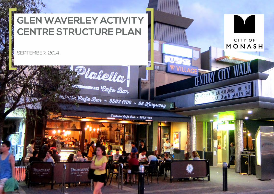
GLEN WAVERLEY ACTIVITY CENTRE STRUCTURE PLAN SEPTEMBER, 2014
2 Glen Waverley Activity Centre STRUCTURE PLAN
Report Name Structure Plan
Reference GR 02
Revision 07
Prepared ByTom Shield, Sinead Holmes and Marnie Dalton
Reviewed By Michael Natoli
Date of Issue 18/9/2014
© Tract Consultants
This publication is subject to copyright. Except as permitted under the Copyright Act 1968, no part of this document may in any form or by any means (electronic, mechanical, photocopying, recording or otherwise) may be reproduced, stored in a retrieval system or transmitted without the prior written permission of Tract Consultants
www.tract.net.au
Project Consultants:
Glen Waverley Activity Centre STRUCTURE PLAN 3
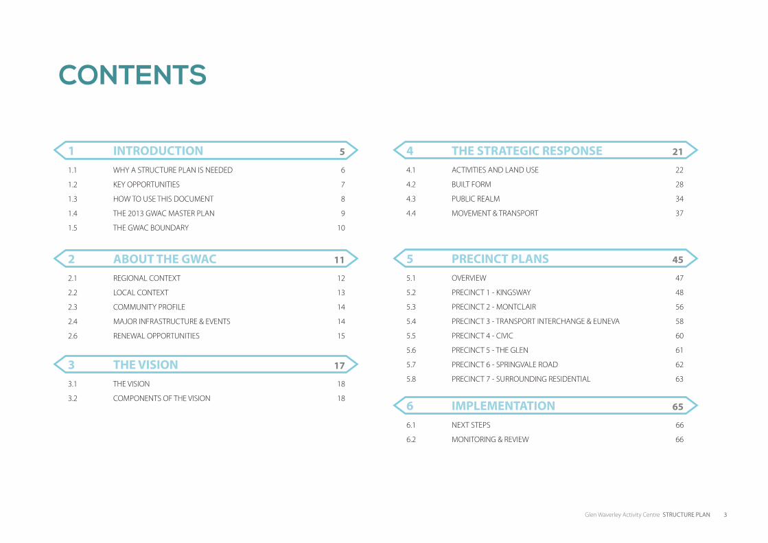
CONTENTS
1 INTRODUCTION 5 4 THE STRATEGIC RESPONSE 21
3 THE VISION 17
2 ABOUT THE GWAC 11 5 PRECINCT PLANS 45
6 IMPLEMENTATION 65
1.1 WHY A STRUCTURE PLAN IS NEEDED 6
1.2 KEY OPPORTUNITIES 7
1.3 HOW TO USE THIS DOCUMENT 8
1.4 THE 2013 GWAC MASTER PLAN 9
1.5 THE GWAC BOUNDARY 10
4.1 ACTIVITIES AND LAND USE 22
4.2 BUILT FORM 28
4.3 PUBLIC REALM 34
4.4 MOVEMENT & TRANSPORT 37
3.1 THE VISION 18
3.2 COMPONENTS OF THE VISION 18
2.1 REGIONAL CONTEXT 12
2.2 LOCAL CONTEXT 13
2.3 COMMUNITY PROFILE 14
2.4 MAJOR INFRASTRUCTURE & EVENTS 14
2.6 RENEWAL OPPORTUNITIES 15
5.1 OVERVIEW 47
5.2 PRECINCT 1 - KINGSWAY 48
5.3 PRECINCT 2 - MONTCLAIR 56
5.4 PRECINCT 3 - TRANSPORT INTERCHANGE & EUNEVA 58
5.5 PRECINCT 4 - CIVIC 60
5.6 PRECINCT 5 - THE GLEN 61
5.7 PRECINCT 6 - SPRINGVALE ROAD 62
5.8 PRECINCT 7 - SURROUNDING RESIDENTIAL 63
6.1 NEXT STEPS 66
6.2 MONITORING & REVIEW 66

4 Glen Waverley Activity Centre STRUCTURE PLAN
This page has been left blank intentionally

1INTRODUCTION

6 Glen Waverley Activity Centre STRUCTURE PLAN
1. INTRODUCTION 1.1 WHY A STRUCTURE PLAN IS NEEDEDGlen Waverley is identified as an Activity Centre under Plan Melbourne. As an Activity Centre, Glen Waverley is expected to provide a mix of businesses, retail, services and entertainment uses, additional housing and highly connected public transport services.
The population within the suburb of Glen Waverley is expected to grow and change over the period until 2031. An increase in population from 41,819 to 45,562 (an additional 3,743 people) is forecast, with an additional 1,601 dwellings required in the same period. Households will become smaller and the population will age.
It is anticipated that a significant amount of the additional housing will be provided in locations such as the GWAC where there is excellent access to shops, services and public transport. This will have a number of implications on the future planning and development of the GWAC including:
• The built form character of the centre will need to change to accommodate additional housing, and expanded retail and commercial facilities
• Shops, services, employment and community facilities will need to improve to respond to the increase in population and changing demographics
• Additional public spaces will need to be provided to serve the increased residents and workers
• Household types will need to respond to the ageing population and smaller household sizes
The Structure Plan provides a clear framework for managing the future growth and change of Glen Waverley. It will help to guide public and private investment while ensuring the centre develops in an orderly and sustainable way.
Figure 1: An artists impression of the public square and community hub
The Structure Plan outlines a 20 year plan for the growth and improvement of the Glen Waverley Activity Centre (GWAC).
The document sets out a vision for the GWAC and a number of strategies and initiatives required to achieve the vision.
The Structure Plan builds on a significant body of work developed as part of the Glen Waverley Activity Centre Masterplan in 2013.

Glen Waverley Activity Centre STRUCTURE PLAN 7
1.2 KEY OPPORTUNITIESThe Structure Plan focuses on achieving the following key opportunities:
Figure 2: Key Structure Plan Opportunities (artist’s impression)
Create a green ‘enveloping’ landscape to the future Ring Road
A network of green pedestrian priority streets connecting into the commercial area
New public open space areas as part of the redevelopment of Council-owned sites
Major renewal opportunity on the central car park site with a public square, community hub and library, and mixed use development
A new public plaza space on Railway Parade North and Coleman Parade
Staged implementation of the Ring Road to reduce traffic along key commercial area streets
A cohesive network of bicycle connections
A new public green within the library forecourt area
Mixed use renewal opportunities, including housing and commercial uses, on Council-owned at-grade car parks across the GWAC
Promote a medical precinct along Springvale Road
Improve streetscape along Kingsway south to enhance pedestrian and cycle priority
Improve streetscape along Kingsway north to enhance pedestrian and cycle priority
BOGONG RESERVE
High Street Rd
Glen RdColeman Pde
Bogong Ave
Bogong Ave
Bogong Ave
O’Sullivan Rd
Montclair AveMontclair Ave
Kingsway
Springvale Rd
Mye
rs Ave
Myrtle St
Myr
tle S
t
8 Glen Waverley Activity Centre STRUCTURE PLAN
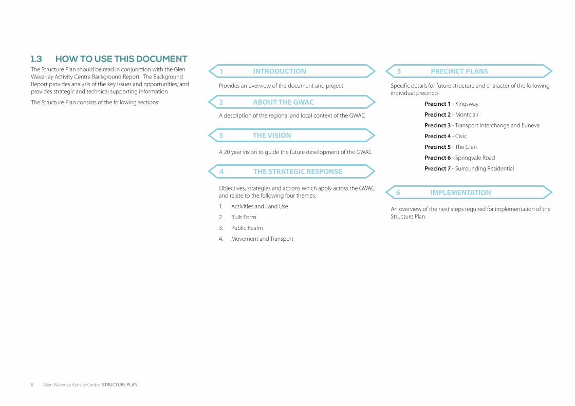
1.3 HOW TO USE THIS DOCUMENTThe Structure Plan should be read in conjunction with the Glen Waverley Activity Centre Background Report. The Background Report provides analysis of the key issues and opportunities, and provides strategic and technical supporting information
The Structure Plan consists of the following sections:
1 INTRODUCTION
6 IMPLEMENTATION
2 ABOUT THE GWAC
3 THE VISION
4 THE STRATEGIC RESPONSE
5 PRECINCT PLANS
Specific details for future structure and character of the following individual precincts:
Precinct 1 - Kingsway
Precinct 2 - Montclair
Precinct 3 - Transport Interchange and Euneva
Precinct 4 - Civic
Precinct 5 - The Glen
Precinct 6 - Springvale Road
Precinct 7 - Surrounding Residential
Provides an overview of the document and project
A description of the regional and local context of the GWAC
A 20 year vision to guide the future development of the GWAC
Objectives, strategies and actions which apply across the GWAC and relate to the following four themes:
1. Activities and Land Use
2. Built Form
3. Public Realm
4. Movement and Transport
An overview of the next steps required for implementation of the Structure Plan.
Glen Waverley Activity Centre STRUCTURE PLAN 9
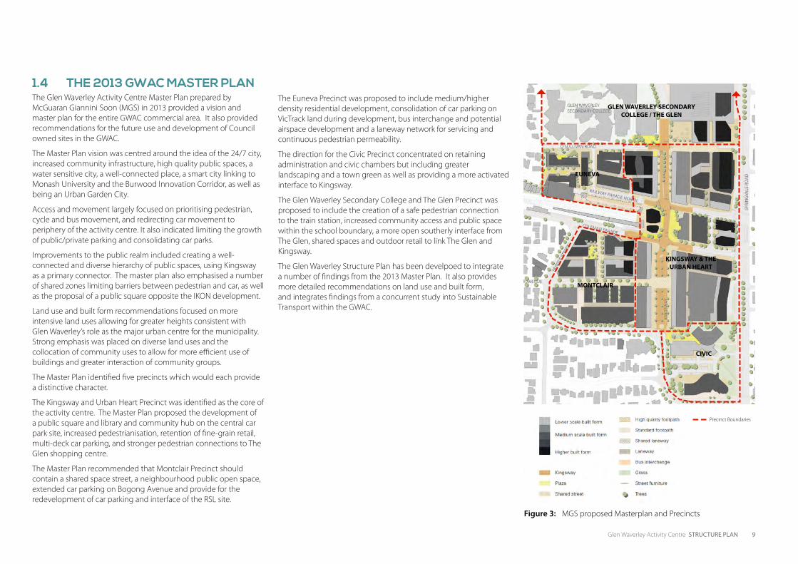
Figure 3: MGS proposed Masterplan and Precincts
1.4 THE 2013 GWAC MASTER PLANThe Glen Waverley Activity Centre Master Plan prepared by McGuaran Giannini Soon (MGS) in 2013 provided a vision and master plan for the entire GWAC commercial area. It also provided recommendations for the future use and development of Council owned sites in the GWAC.
The Master Plan vision was centred around the idea of the 24/7 city, increased community infrastructure, high quality public spaces, a water sensitive city, a well-connected place, a smart city linking to Monash University and the Burwood Innovation Corridor, as well as being an Urban Garden City.
Access and movement largely focused on prioritising pedestrian, cycle and bus movement, and redirecting car movement to periphery of the activity centre. It also indicated limiting the growth of public/private parking and consolidating car parks.
Improvements to the public realm included creating a well-connected and diverse hierarchy of public spaces, using Kingsway as a primary connector. The master plan also emphasised a number of shared zones limiting barriers between pedestrian and car, as well as the proposal of a public square opposite the IKON development.
Land use and built form recommendations focused on more intensive land uses allowing for greater heights consistent with Glen Waverley’s role as the major urban centre for the municipality. Strong emphasis was placed on diverse land uses and the collocation of community uses to allow for more efficient use of buildings and greater interaction of community groups.
The Master Plan identified five precincts which would each provide a distinctive character.
The Kingsway and Urban Heart Precinct was identified as the core of the activity centre. The Master Plan proposed the development of a public square and library and community hub on the central car park site, increased pedestrianisation, retention of fine-grain retail, multi-deck car parking, and stronger pedestrian connections to The Glen shopping centre.
The Master Plan recommended that Montclair Precinct should contain a shared space street, a neighbourhood public open space, extended car parking on Bogong Avenue and provide for the redevelopment of car parking and interface of the RSL site.
The Euneva Precinct was proposed to include medium/higher density residential development, consolidation of car parking on VicTrack land during development, bus interchange and potential airspace development and a laneway network for servicing and continuous pedestrian permeability.
The direction for the Civic Precinct concentrated on retaining administration and civic chambers but including greater landscaping and a town green as well as providing a more activated interface to Kingsway.
The Glen Waverley Secondary College and The Glen Precinct was proposed to include the creation of a safe pedestrian connection to the train station, increased community access and public space within the school boundary, a more open southerly interface from The Glen, shared spaces and outdoor retail to link The Glen and Kingsway.
The Glen Waverley Structure Plan has been develpoed to integrate a number of findings from the 2013 Master Plan. It also provides more detailed recommendations on land use and built form, and integrates findings from a concurrent study into Sustainable Transport within the GWAC.
GLEN WAVERLEY SECONDARY COLLEGE / THE GLEN
KINGSWAY & THE URBAN HEART
MONTCLAIR
CIVIC
EUNEVA
Precinct Boundaries
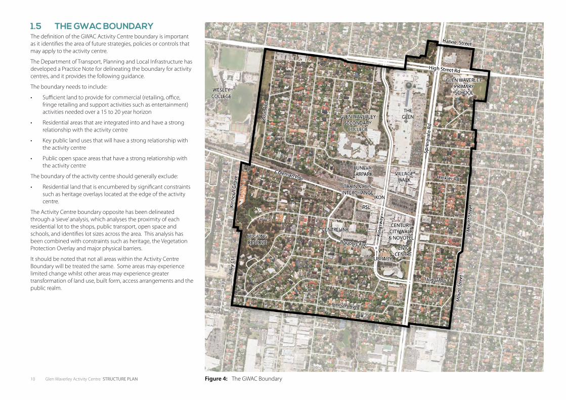
10 Glen Waverley Activity Centre STRUCTURE PLAN Figure 4: The GWAC Boundary
1.5 THE GWAC BOUNDARYThe definition of the GWAC Activity Centre boundary is important as it identifies the area of future strategies, policies or controls that may apply to the activity centre.
The Department of Transport, Planning and Local Infrastructure has developed a Practice Note for delineating the boundary for activity centres, and it provides the following guidance.
The boundary needs to include:
• Sufficient land to provide for commercial (retailing, office, fringe retailing and support activities such as entertainment) activities needed over a 15 to 20 year horizon
• Residential areas that are integrated into and have a strong relationship with the activity centre
• Key public land uses that will have a strong relationship with the activity centre
• Public open space areas that have a strong relationship with the activity centre
The boundary of the activity centre should generally exclude:
• Residential land that is encumbered by significant constraints such as heritage overlays located at the edge of the activity centre.
The Activity Centre boundary opposite has been delineated through a ‘sieve’ analysis, which analyses the proximity of each residential lot to the shops, public transport, open space and schools, and identifies lot sizes across the area. This analysis has been combined with constraints such as heritage, the Vegetation Protection Overlay and major physical barriers.
It should be noted that not all areas within the Activity Centre Boundary will be treated the same. Some areas may experience limited change whilst other areas may experience greater transformation of land use, built form, access arrangements and the public realm.
2ABOUT THE GWAC
12 Glen Waverley Activity Centre STRUCTURE PLAN
2. ABOUT THE GWAC
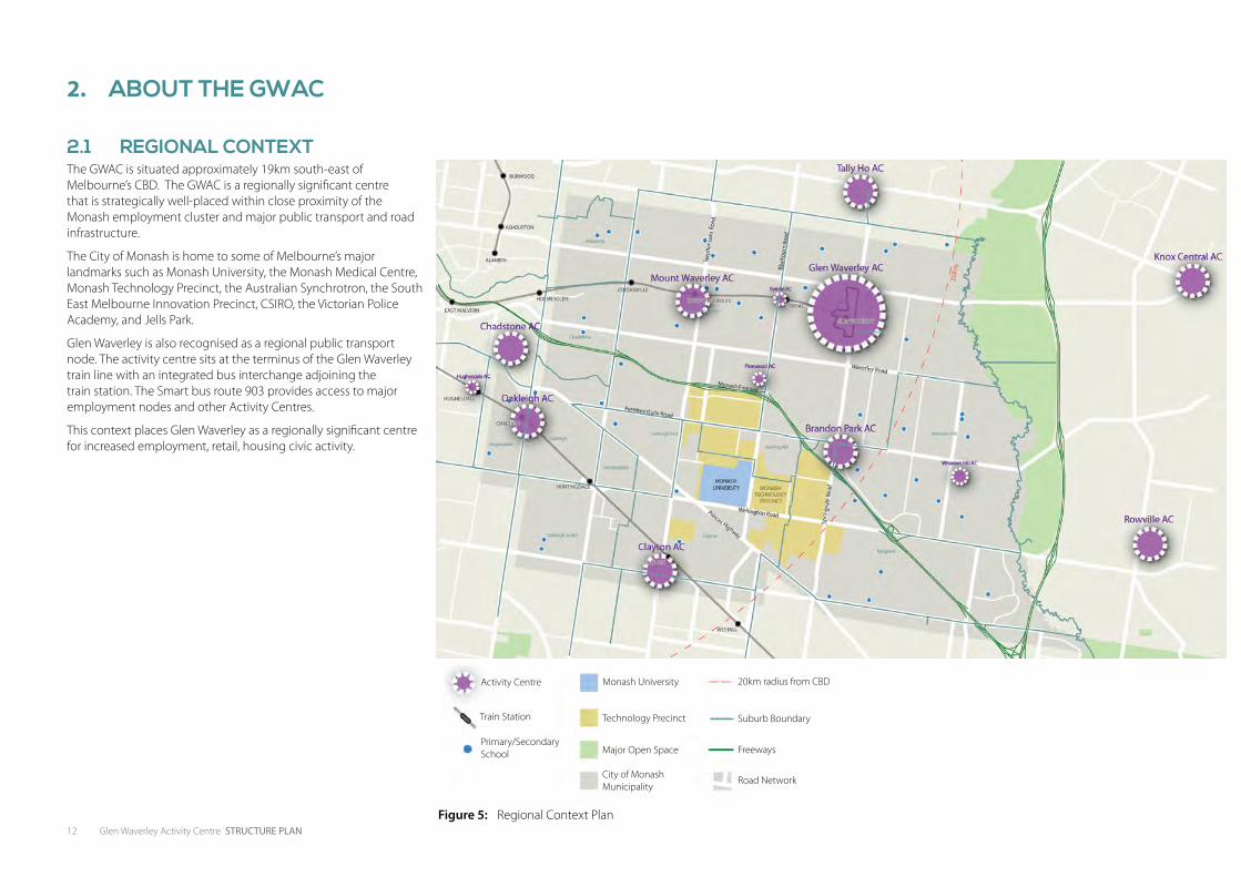
2.1 REGIONAL CONTEXTThe GWAC is situated approximately 19km south-east of Melbourne’s CBD. The GWAC is a regionally significant centre that is strategically well-placed within close proximity of the Monash employment cluster and major public transport and road infrastructure.
The City of Monash is home to some of Melbourne’s major landmarks such as Monash University, the Monash Medical Centre, Monash Technology Precinct, the Australian Synchrotron, the South East Melbourne Innovation Precinct, CSIRO, the Victorian Police Academy, and Jells Park.
Glen Waverley is also recognised as a regional public transport node. The activity centre sits at the terminus of the Glen Waverley train line with an integrated bus interchange adjoining the train station. The Smart bus route 903 provides access to major employment nodes and other Activity Centres.
This context places Glen Waverley as a regionally significant centre for increased employment, retail, housing civic activity.
Activity Centre Monash University 20km radius from CBD
Technology Precinct Suburb Boundary
Major Open Space Freeways
City of Monash Municipality
Road Network
Train Station
Primary/Secondary School
Figure 5: Regional Context Plan
Glen Waverley Activity Centre STRUCTURE PLAN 13
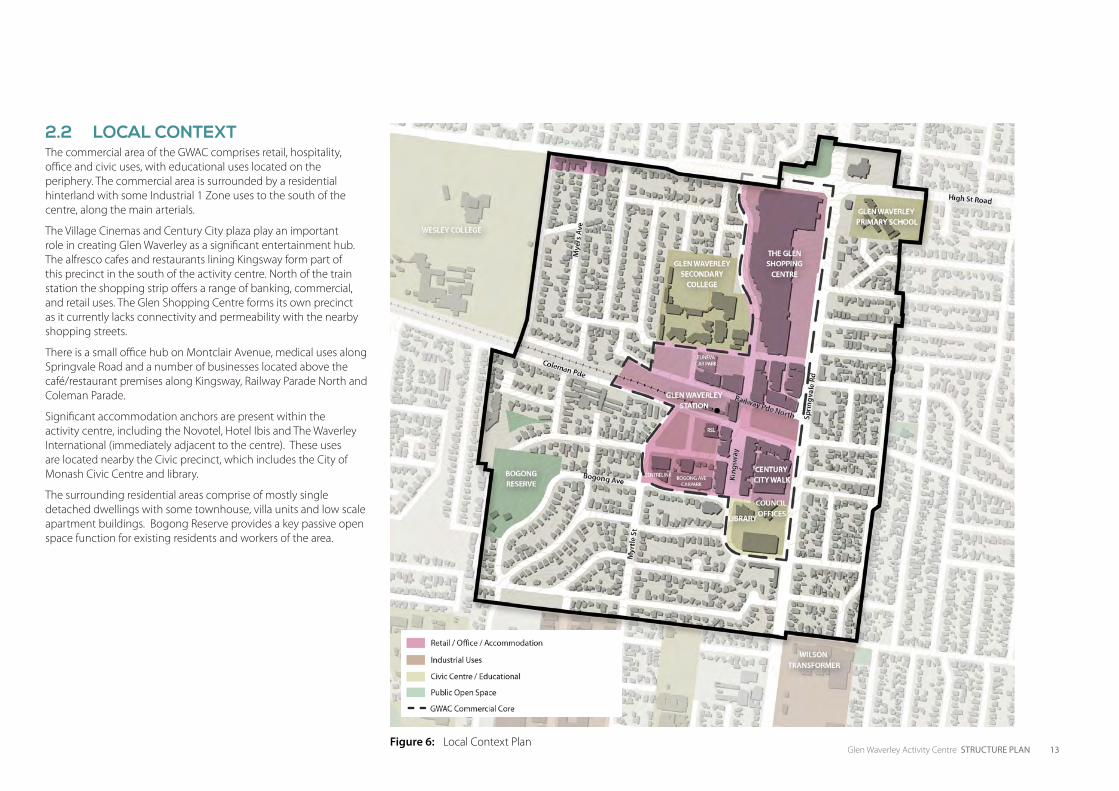
2.2 LOCAL CONTEXTThe commercial area of the GWAC comprises retail, hospitality, office and civic uses, with educational uses located on the periphery. The commercial area is surrounded by a residential hinterland with some Industrial 1 Zone uses to the south of the centre, along the main arterials.
The Village Cinemas and Century City plaza play an important role in creating Glen Waverley as a significant entertainment hub. The alfresco cafes and restaurants lining Kingsway form part of this precinct in the south of the activity centre. North of the train station the shopping strip offers a range of banking, commercial, and retail uses. The Glen Shopping Centre forms its own precinct as it currently lacks connectivity and permeability with the nearby shopping streets.
There is a small office hub on Montclair Avenue, medical uses along Springvale Road and a number of businesses located above the café/restaurant premises along Kingsway, Railway Parade North and Coleman Parade.
Significant accommodation anchors are present within the activity centre, including the Novotel, Hotel Ibis and The Waverley International (immediately adjacent to the centre). These uses are located nearby the Civic precinct, which includes the City of Monash Civic Centre and library.
The surrounding residential areas comprise of mostly single detached dwellings with some townhouse, villa units and low scale apartment buildings. Bogong Reserve provides a key passive open space function for existing residents and workers of the area.
Figure 6: Local Context Plan
14 Glen Waverley Activity Centre STRUCTURE PLAN
2.3 COMMUNITY PROFILEN.B. The profile below is based on the study area identified in the Glen Waverley catchment area as specified in the ABS Census 2011 data. This area is slightly larger than the GWAC, however it incorporates the city centre and surrounding residential areas.
Glen Waverley is a diverse community, with 48.7% of people born overseas. The highest proportion are born in China (10.4%), followed by Malaysia (5.2%), Sri Lanka (4.5%), Indian (4.5%) and England (2.8%).
The ageing population trend is more prominent in Glen Waverley than in the whole of the municipality, with 24.9% of the population over 60 years of age. In contrast, only 3.9% of the Glen Waverley population are pre-schoolers or younger. However 20.3% are in the category of ‘parents/home-builders’ and a significant proportion are within the 18-24 bracket (10.9%).
Individual income levels within Glen Waverley are generally similar to that of metropolitan Melbourne for the key age groups either purchasing (35-54 years) or renting (25-34 years) new housing.
Residents within Glen Waverley are increasingly higher educated which is consistent with metropolitan and national trends.
Even with strong transportation links from Glen Waverley to the CBD, 61.5% choose to travel by car to work followed by train at 14.1%.
2.4 MAJOR PROJECTS AND INFRASTRUCTURE There are several recently completed and committed major projects which will influence the role and function of the GWAC. These include:
• Glen Waverley Station Enhancement - Improvements to the entrance area of the station. Project underway.
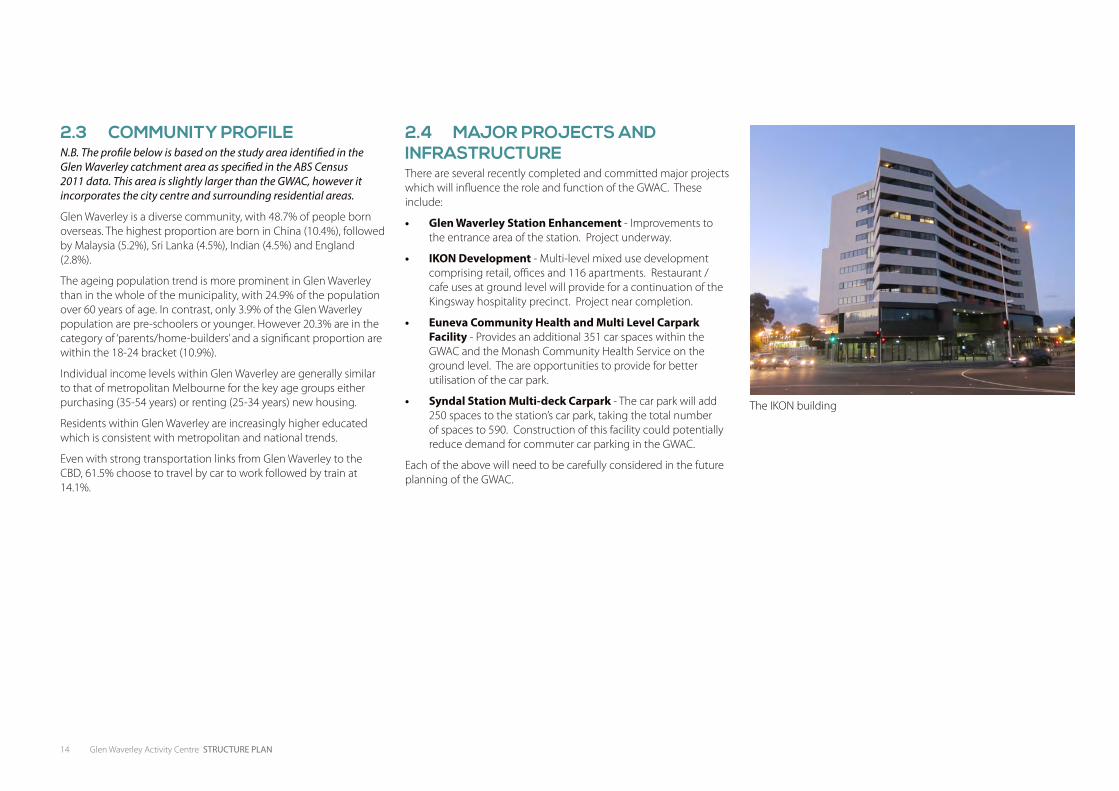
• IKON Development - Multi-level mixed use development comprising retail, offices and 116 apartments. Restaurant / cafe uses at ground level will provide for a continuation of the Kingsway hospitality precinct. Project near completion.
• Euneva Community Health and Multi Level Carpark Facility - Provides an additional 351 car spaces within the GWAC and the Monash Community Health Service on the ground level. The are opportunities to provide for better utilisation of the car park.
• Syndal Station Multi-deck Carpark - The car park will add 250 spaces to the station’s car park, taking the total number of spaces to 590. Construction of this facility could potentially reduce demand for commuter car parking in the GWAC.
Each of the above will need to be carefully considered in the future planning of the GWAC.
The IKON building
Glen Waverley Activity Centre STRUCTURE PLAN 15
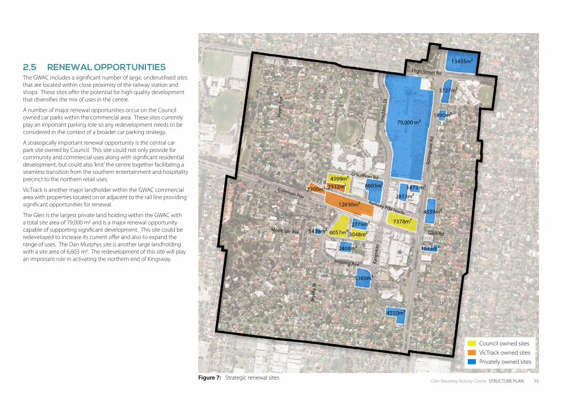
2.5 RENEWAL OPPORTUNITIESThe GWAC includes a significant number of large, underutilised sites that are located within close proximity of the railway station and shops. These sites offer the potential for high quality development that diversifies the mix of uses in the centre.
A number of major renewal opportunities occur on the Council owned car parks within the commercial area. These sites currently play an important parking role so any redevelopment needs to be considered in the context of a broader car parking strategy.
A strategically important renewal opportunity is the central car park site owned by Council. This site could not only provide for community and commercial uses along with significant residential development, but could also ‘knit’ the centre together facilitating a seamless transition from the southern entertainment and hospitality precinct to the northern retail uses.
VicTrack is another major landholder within the GWAC commercial area with properties located on or adjacent to the rail line providing significant opportunities for renewal.
The Glen is the largest private land holding within the GWAC with a total site area of 79,000 m2 and is a major renewal opportunity capable of supporting significant development. This site could be redeveloped to increase its current offer and also to expand the range of uses. The Dan Murphys site is another large landholding with a site area of 6,603 m2. The redevelopment of this site will play an important role in activating the northern end of Kingsway.
Council owned sitesVicTrack owned sitesPrivately owned sites
High Street Rd
Glen Rd
Bogong Ave
Coleman Pde Railway Pde North
O’Sullivan Rd
Montclair Ave
Sprin
gval
e Rd
King
sway
Sned
den
Dr
Mye
rs A
ve
Myr
tle S
t
Figure 7: Strategic renewal sites

16 Glen Waverley Activity Centre STRUCTURE PLAN
This page has been left blank intentionally

3THE VISION
18 Glen Waverley Activity Centre STRUCTURE PLAN
3. THE VISION
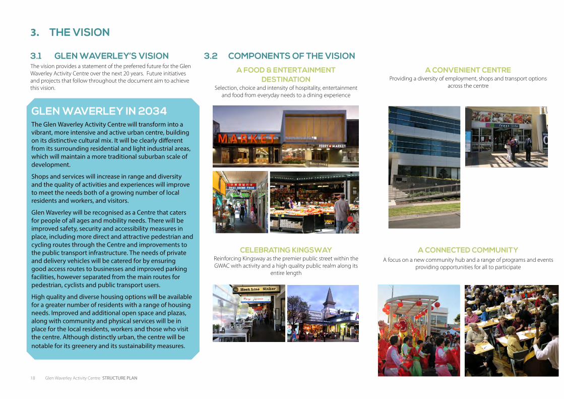
3.1 GLEN WAVERLEY’S VISIONThe vision provides a statement of the preferred future for the Glen Waverley Activity Centre over the next 20 years. Future initiatives and projects that follow throughout the document aim to achieve this vision.
GLEN WAVERLEY IN 2034The Glen Waverley Activity Centre will transform into a vibrant, more intensive and active urban centre, building on its distinctive cultural mix. It will be clearly different from its surrounding residential and light industrial areas, which will maintain a more traditional suburban scale of development.
Shops and services will increase in range and diversity and the quality of activities and experiences will improve to meet the needs both of a growing number of local residents and workers, and visitors.
Glen Waverley will be recognised as a Centre that caters for people of all ages and mobility needs. There will be improved safety, security and accessibility measures in place, including more direct and attractive pedestrian and cycling routes through the Centre and improvements to the public transport infrastructure. The needs of private and delivery vehicles will be catered for by ensuring good access routes to businesses and improved parking facilities, however separated from the main routes for pedestrian, cyclists and public transport users.
High quality and diverse housing options will be available for a greater number of residents with a range of housing needs. Improved and additional open space and plazas, along with community and physical services will be in place for the local residents, workers and those who visit the centre. Although distinctly urban, the centre will be notable for its greenery and its sustainability measures.
A FOOD & ENTERTAINMENT DESTINATION
Selection, choice and intensity of hospitality, entertainment and food from everyday needs to a dining experience
A CONVENIENT CENTREProviding a diversity of employment, shops and transport options
across the centre
CELEBRATING KINGSWAY Reinforcing Kingsway as the premier public street within the GWAC with activity and a high quality public realm along its
entire length
A CONNECTED COMMUNITYA focus on a new community hub and a range of programs and events
providing opportunities for all to participate
3.2 COMPONENTS OF THE VISION
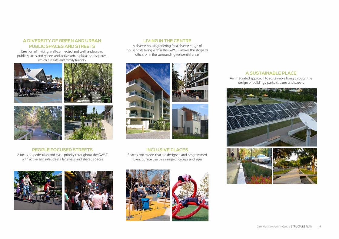
Glen Waverley Activity Centre STRUCTURE PLAN 19
INCLUSIVE PLACESSpaces and streets that are designed and programmed
to encourage use by a range of groups and ages
LIVING IN THE CENTREA diverse housing offering for a diverse range of
households living within the GWAC - above the shops or office, or in the surrounding residential areas
A SUSTAINABLE PLACEAn integrated approach to sustainable living through the
design of buildings, parks, squares and streets
PEOPLE FOCUSED STREETSA focus on pedestrian and cycle priority throughout the GWAC
with active and safe streets, laneways and shared spaces
A DIVERSITY OF GREEN AND URBAN PUBLIC SPACES AND STREETS
Creation of inviting, well-connected and well landscaped public spaces and streets and active urban plazas and squares,
which are safe and family friendly

20 Glen Waverley Activity Centre STRUCTURE PLAN
This page has been left blank intentionally

4THE STRATEGIC RESPONSE

22 Glen Waverley Activity Centre STRUCTURE PLAN
4.1 ACTIVITIES AND LAND USEThe Vision seeks to provide greater opportunities for Kingsway’s food/dining/entertainment hub to be further enhanced and expanded. There are also numerous opportunities and demand for residential living in the heart of the GWAC. Complementary to these uses are the possible expansion of the medical and office uses that already exist. Figure 8 reflects the proposed future land uses across the GWAC.
A. RETAILThe Glen Shopping Centre provides for the majority of retail uses within the GWAC and anchors the centre’s northern precinct.
The GWAC has a focus upon Asian retailing, albeit largely concentrated within the Kingsway precinct. Although dominated by cafés and restaurants, there is also a small number of grocery and fresh food retailers.
While the Kingsway precinct is predominantly a restaurant precinct, the popularity of eateries as a daytime activity distinguishes it from many suburban restaurant precincts that are most active during the evening. As a result, Kingsway provides a southern anchor for the GWAC throughout the day and evening, and provides the opportunity for establishing synergies with traditional retail activities within the centre.
Outside of The Glen and Kingsway, retail activity is spread across a number of smaller disconnected precincts that cater for a mix of retail, hospitality and business activities with few obvious synergies between the businesses within each. As a result, there are limited opportunities to undertake weekly (or more frequent) shopping activities such as supermarket and food shopping in one convenient location.
There is the opportunity to concentrate the GWAC’s fresh food retailing offer in a central, convenient location to better meet the needs of residents. A fresh food precinct anchored by a smaller format supermarket together with a range of unique food specialities (gourmet or ethnic foods) would provide a distinct lifestyle focus with synergies to both Kingsway and The Glen Shopping Centre.
Continued growth in the number of residents of Asian ancestry across the surrounding region will provide opportunities for niche retailing including retail centres dedicated to meeting the retail needs of this group. The experience of the Canadian cities of Toronto and Vancouver highlights the potential for such centres, and within the GWAC there are a number of sites that may represent a potential location for such a centre.
ObjectiveTo reinforce the GWAC as a major retail destination meeting both regional and local needs
Strategies• Support the expansion of The Glen Shopping Centre with
additional uses that complement the balance of the GWAC commercial area
• Support The Glen Shopping Centre as a key redevelopment opportunity and major employment node in the GWAC
• Provide better integration of the Glen into the surrounding street network with improved pedestrian connections, active frontages and improved interface with Springvale Road and High Street Road
• Support the retention of local retail uses along Kingsway
• Support the development of a fresh food precinct in a central location within the GWAC
ActionsA.1 Facilitate the future expansion of The Glen Shopping Centre
to provide an extended offer and improved integration into the GWAC streets. Integration improvements should focus on additional pedestrian connections into the centre from all directions, active frontages to surrounding streets and a high quality built form presence to Springvale Road and High Street Road
A.2 Investigate opportunities for the development of a fresh food precinct within the GWAC commercial area to complement and strengthen the Kingsway hospitality and entertainment uses
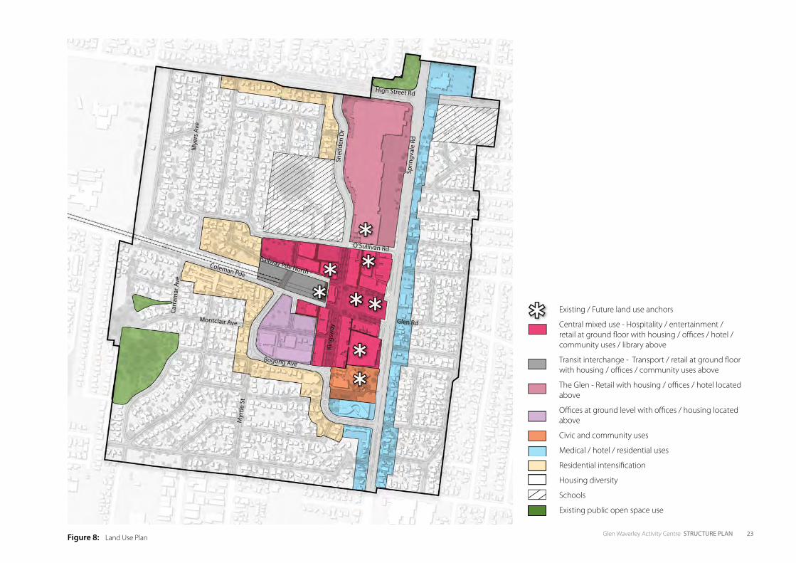
Glen Waverley Activity Centre STRUCTURE PLAN 23Figure 8: Land Use Plan
Existing / Future land use anchors
Central mixed use - Hospitality / entertainment / retail at ground floor with housing / offices / hotel / community uses / library above
Transit interchange - Transport / retail at ground floor with housing / offices / community uses above
The Glen - Retail with housing / offices / hotel located above
Offices at ground level with offices / housing located above
Civic and community uses
Medical / hotel / residential uses
Residential intensification
Housing diversity
Schools
Existing public open space use
High Street Rd
Glen Rd
Bogong Ave
Coleman Pde
Railway Pde North
O’Sullivan Rd
Montclair Ave
Sprin
gval
e Rd
King
sway
Sned
den
Dr
Mye
rs A
ve
Myr
tle S
t
Carr
amar
Ave
24 Glen Waverley Activity Centre STRUCTURE PLAN
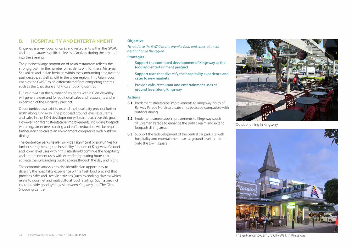
B. HOSPITALITY AND ENTERTAINMENTKingsway is a key focus for cafés and restaurants within the GWAC and demonstrates significant levels of activity during the day and into the evening.
The precinct’s large proportion of Asian restaurants reflects the strong growth in the number of residents with Chinese, Malaysian, Sri Lankan and Indian heritage within the surrounding area over the past decade, as well as within the wider region. This Asian focus enables the GWAC to be differentiated from competing centres such as the Chadstone and Knox Shopping Centres.
Future growth in the number of residents within Glen Waverley will generate demand for additional cafés and restaurants and an expansion of the Kingsway precinct.
Opportunities also exist to extend the hospitality precinct further north along Kingsway. The proposed ground level restaurants and cafés in the IKON development will start to achieve this goal. However significant streetscape improvements, including footpath widening, street tree planting and traffic reduction, will be required further north to create an environment compatible with outdoor dining.
The central car park site also provides significant opportunities for further strengthening the hospitality function of Kingsway. Ground and lower level uses within this site should continue the hospitality and entertainment uses with extended operating hours that activate the surrounding public spaces through the day and night.
The economic analysis has also identified an opportunity to diversify the hospitality experience with a fresh food precinct that provides cafés and lifestyle activities (such as cooking classes) which relate to gourmet and multicultural food retailing. Such a precinct could provide good synergies between Kingsway and The Glen Shopping Centre.
ObjectiveTo reinforce the GWAC as the premier food and entertainment destination in the region
Strategies• Support the continued development of Kingsway as the
food and entertainment precinct
• Support uses that diversify the hospitality experience and cater to new markets
• Provide cafe, restaurant and entertainment uses at ground level along Kingsway
ActionsB.1 Implement streetscape improvements to Kingsway north of
Railway Parade North to create an streetscape compatible with outdoor dining
B.2 Implement streetscape improvements to Kingsway south of Coleman Parade to enhance the public realm and extend footpath dining areas
B.3 Support the redevelopment of the central car park site with hospitality and entertainment uses at ground level that front onto the town square
The entrance to Century City Walk in Kingsway
Outdoor dining in Kingsway
Glen Waverley Activity Centre STRUCTURE PLAN 25
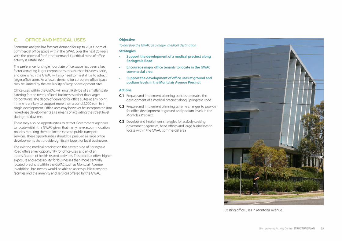
C. OFFICE AND MEDICAL USESEconomic analysis has forecast demand for up to 20,000 sqm of commercial office space within the GWAC over the next 20 years with the potential for further demand if a critical mass of office activity is established.
The preference for single floorplate office space has been a key factor attracting larger corporations to suburban business parks, and one which the GWAC will also need to meet if it is to attract larger office users. As a result, demand for corporate office space may be limited by the availability of larger development sites.
Office uses within the GWAC will most likely be of a smaller scale, catering for the needs of local businesses rather than larger corporations. The depth of demand for office suites at any point in time is unlikely to support more than around 2,000 sqm in a single development. Office uses may however be incorporated into mixed-use developments as a means of activating the street level during the daytime.
There may also be opportunities to attract Government agencies to locate within the GWAC given that many have accommodation policies requiring them to locate close to public transport services. These opportunities should be pursued as large office developments that provide significant boost for local businesses.
The existing medical precinct on the eastern side of Springvale Road offers a key opportunity for office uses as part of an intensification of health related activities. This precinct offers higher exposure and accessibility for businesses than more centrally located precincts within the GWAC such as Montclair Avenue. In addition, businesses would be able to access public transport facilities and the amenity and services offered by the GWAC.
ObjectiveTo develop the GWAC as a major medical destination
Strategies• Support the development of a medical precinct along
Springvale Road
• Encourage major office tenants to locate in the GWAC commercial area
• Support the development of office uses at ground and podium levels in the Montclair Avenue Precinct
ActionsC.1 Prepare and implement planning policies to enable the
development of a medical precinct along Springvale Road
C.2 Prepare and implement planning scheme changes to provide for office development at ground and podium levels in the Montclair Precinct
C.3 Develop and implement strategies for actively seeking government agencies, head offices and large businesses to locate within the GWAC commercial area
Existing office uses in Montclair Avenue
26 Glen Waverley Activity Centre STRUCTURE PLAN
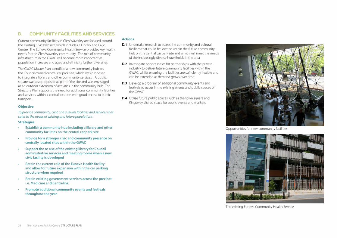
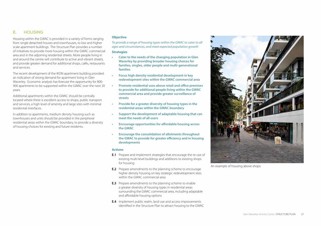
D. COMMUNITY FACILITIES AND SERVICESCurrent community facilities in Glen Waverley are focused around the existing Civic Precinct, which includes a Library and Civic Centre. The Euneva Community Health Service provides key health needs for the Glen Waverley community. The role of community infrastructure in the GWAC will become more important as population increases and ages, and ethnicity further diversifies.
The GWAC Master Plan identified a new community hub on the Council owned central car park site, which was proposed to integrate a library and other community services. A public square was also proposed as part of the site and was envisaged as an outdoor extension of activities in the community hub. The Structure Plan supports the need for additional community facilities and services within a central location with good access to public transport.
Objective To provide community, civic and cultural facilities and services that cater to the needs of existing and future populations
Strategies• Establish a community hub including a library and other
community facilities on the central car park site
• Provide for a stronger civic and community presence on centrally located sites within the GWAC
• Support the re-use of the existing library for Council administrative services and meeting rooms when a new civic facility is developed
• Retain the current role of the Euneva Health facility and allow for future expansion within the car parking structure when required
• Retain existing government services across the precinct i.e. Medicare and Centrelink
• Promote additional community events and festivals throughout the year
ActionsD.1 Undertake research to assess the community and cultural
facilities that could be located within the future community hub on the central car park site and which will meet the needs of the increasingly diverse households in the area
D.2 Investigate opportunities for partnerships with the private industry to deliver future community facilities within the GWAC, whilst ensuring the facilities are sufficiently flexible and can be extended as demand grows over time
D.3 Develop a program of additional community events and festivals to occur in the existing streets and public spaces of the GWAC
D.4 Utilise future public spaces such as the town square and Kingsway shared space for public events and markets
Opportunities for new community facilities
The existing Euneva Community Health Service
Glen Waverley Activity Centre STRUCTURE PLAN 27
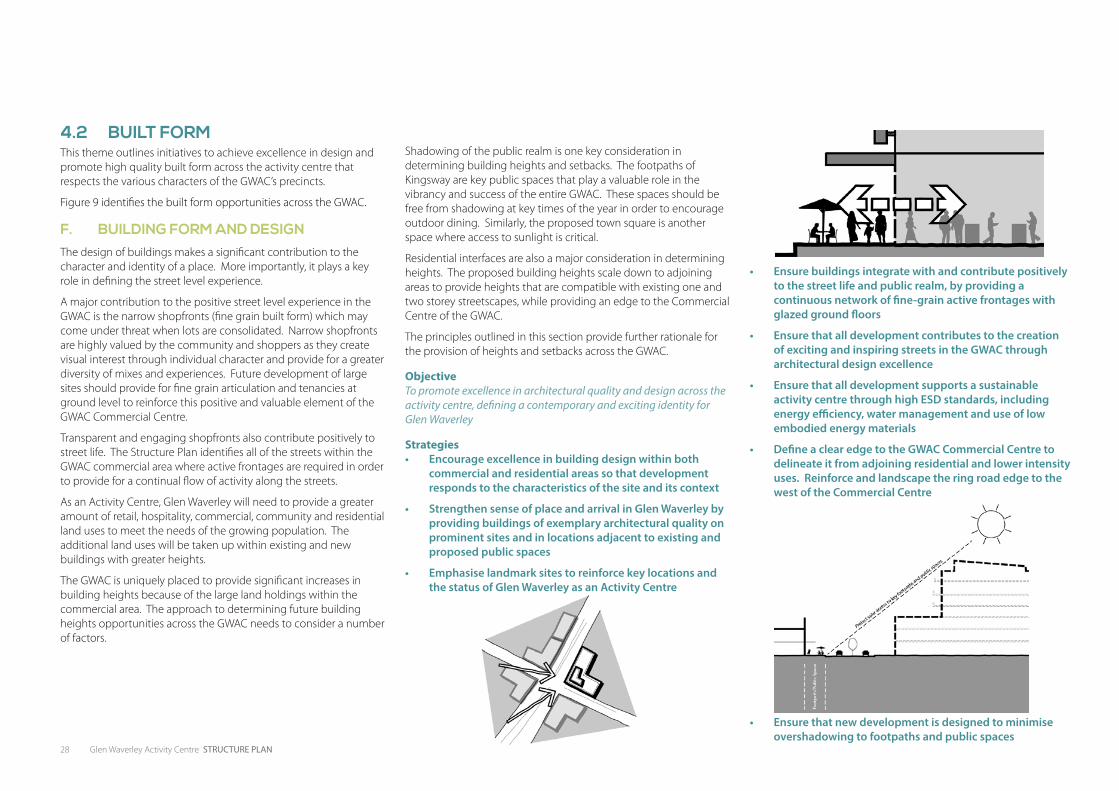
E. HOUSINGHousing within the GWAC is provided in a variety of forms ranging from single detached houses and townhouses, to low and higher scale apartment buildings. The Structure Plan provides a number of initiatives to provide more housing within the GWAC commercial area and in the adjoining residential streets. More people living in and around the centre will contribute to active and vibrant streets, and provide greater demand for additional shops, cafés, restaurants and services.
The recent development of the IKON apartment building provided an indication of strong demand for apartment living in Glen Waverley. Economic analysis has forecast the opportunity for 800-900 apartments to be supported within the GWAC over the next 20 years.
Additional apartments within the GWAC should be centrally located where there is excellent access to shops, public transport and services, a high level of amenity and large sites with minimal residential interfaces.
In addition to apartments, medium density housing such as townhouses and units should be provided in the peripheral residential areas within the GWAC boundary, to provide a diversity of housing choices for existing and future residents.
ObjectiveTo provide a range of housing types within the GWAC to cater to all ages and circumstances, and meet expected population growth
Strategies• Cater to the needs of the changing population in Glen
Waverley by providing broader housing choices for families, singles, older people and multi-generational families
• Focus high density residential development in key redevelopment sites within the GWAC commercial area
• Promote residential uses above retail and office premises to provide for additional people living within the GWAC commercial area and provide greater surveillance of streets
• Provide for a greater diversity of housing types in the residential areas within the GWAC boundary
• Support the development of adaptable housing that can meet the needs of all users
• Encourage opportunities for affordable housing across the GWAC
• Encourage the consolidation of allotments throughout the GWAC to provide for greater efficiency and in housing developments
ActionsE.1 Prepare and implement strategies that encourage the re-use of
existing multi-level buildings and additions to existing shops for housing
E.2 Prepare amendments to the planning scheme to encourage higher density housing on key strategic redevelopment sites within the GWAC commercial area
E.3 Prepare amendments to the planning scheme to enable a greater diversity of housing types in residential areas surrounding the GWAC commercial area, including adaptable and affordable housing options
E.4 Implement public realm, land use and access improvements identified in the Structure Plan to attract housing to the GWAC
An example of housing above shops
28 Glen Waverley Activity Centre STRUCTURE PLAN
4.2 BUILT FORMThis theme outlines initiatives to achieve excellence in design and promote high quality built form across the activity centre that respects the various characters of the GWAC’s precincts.
Figure 9 identifies the built form opportunities across the GWAC.
F. BUILDING FORM AND DESIGNThe design of buildings makes a significant contribution to the character and identity of a place. More importantly, it plays a key role in defining the street level experience.
A major contribution to the positive street level experience in the GWAC is the narrow shopfronts (fine grain built form) which may come under threat when lots are consolidated. Narrow shopfronts are highly valued by the community and shoppers as they create visual interest through individual character and provide for a greater diversity of mixes and experiences. Future development of large sites should provide for fine grain articulation and tenancies at ground level to reinforce this positive and valuable element of the GWAC Commercial Centre.
Transparent and engaging shopfronts also contribute positively to street life. The Structure Plan identifies all of the streets within the GWAC commercial area where active frontages are required in order to provide for a continual flow of activity along the streets.
As an Activity Centre, Glen Waverley will need to provide a greater amount of retail, hospitality, commercial, community and residential land uses to meet the needs of the growing population. The additional land uses will be taken up within existing and new buildings with greater heights.
The GWAC is uniquely placed to provide significant increases in building heights because of the large land holdings within the commercial area. The approach to determining future building heights opportunities across the GWAC needs to consider a number of factors.
Shadowing of the public realm is one key consideration in determining building heights and setbacks. The footpaths of Kingsway are key public spaces that play a valuable role in the vibrancy and success of the entire GWAC. These spaces should be free from shadowing at key times of the year in order to encourage outdoor dining. Similarly, the proposed town square is another space where access to sunlight is critical.
Residential interfaces are also a major consideration in determining heights. The proposed building heights scale down to adjoining areas to provide heights that are compatible with existing one and two storey streetscapes, while providing an edge to the Commercial Centre of the GWAC.
The principles outlined in this section provide further rationale for the provision of heights and setbacks across the GWAC.
ObjectiveTo promote excellence in architectural quality and design across the activity centre, defining a contemporary and exciting identity for Glen Waverley
Strategies• Encourage excellence in building design within both
commercial and residential areas so that development responds to the characteristics of the site and its context
• Strengthen sense of place and arrival in Glen Waverley by providing buildings of exemplary architectural quality on prominent sites and in locations adjacent to existing and proposed public spaces
• Emphasise landmark sites to reinforce key locations and the status of Glen Waverley as an Activity Centre
• Ensure buildings integrate with and contribute positively to the street life and public realm, by providing a continuous network of fine-grain active frontages with glazed ground floors
• Ensure that all development contributes to the creation of exciting and inspiring streets in the GWAC through architectural design excellence
• Ensure that all development supports a sustainable activity centre through high ESD standards, including energy efficiency, water management and use of low embodied energy materials
• Define a clear edge to the GWAC Commercial Centre to delineate it from adjoining residential and lower intensity uses. Reinforce and landscape the ring road edge to the west of the Commercial Centre
• Ensure that new development is designed to minimise overshadowing to footpaths and public spaces
Glen Waverley Activity Centre STRUCTURE PLAN 29
• Ensure solar access is maintained to specific footpaths and/or public spaces at 21 September as follows:
Location Time of day Distance from property line (m)
Eastern side of Kingsway between Bogong Ave & Railway Pde North 12pm - 3pm 10
Western side of Kingsway between Bogong Ave & Railway Pde North 9am -12pm 10
Eastern side of Kingsway between Railway Pde North & O’Sullivan Rd 12pm - 3pm 5
Western side of Kingsway between Railway Pde North & O’Sullivan Rd 9am - 12pm 5
80% of proposed town square located on the current car park site between Coleman Pde & Railway
Pde North
9am - 3pm N/A
Figure 9: Solar access requirements for Kingsway and the proposed town square
• Enhance views to the GWAC by considering the impact of new buildings on the skyline and the contribution it makes to the way that Glen Waverley is viewed from surrounding public viewing locations
• Provide minimum space of 10-12m between tower forms to ensure good levels of access to light, air and views
• Ensure tower forms are generally no more than 18-22m in width and 35-40m in length
• Minimise the visual bulk of large buildings through significant breaks and recesses in building massing
• Provide opportunities for activation of upper podium levels, to support passive surveillance of the public realm
• Ensure that new developments contribute to the ‘buildings-in-landscape’ character of the existing residential areas surrounding the GWAC Commercial Centre, through mature tree planting in front, side and rear setbacks
• Ensure that all development with sensitive interfaces to residential areas and open space is designed to respect valuable qualities of those adjacent places
• Ensure that future development provides shared amenity and equitable access to ensure the impacts of new development on adjoining existing uses are considered
• Ensure that taller buildings are designed as slender tower forms, oriented to minimise overshadowing of the public realm
• Reinforce active street frontages within the GWAC Commercial Centre through zero-setback 2-3 level podiums, where practicable
• Ensure that the generally low-scale character of Kingsway is maintained by limiting height and providing setbacks to upper levels on adjacent properties
• Provide 5m setbacks to upper levels of new developments to minimise wind effects on the street, encourage good solar access and support a human-scaled place
• Ensure that buildings provide wind and weather protection to reduce the impact of wind and rain on key public spaces and provide adequate shade for people
• Ensure new developments over 6 storeys are designed to avoid or mitigate wind effects at street level
• Ensure development can be adequately serviced from existing roads with minimal impact on public spaces. Where redevelopment occurs, ensure laneways are widened to generally 6-8m
• Ensure that pedestrian permeability throughout the GWAC is supported through mid-block links, particularly on large development sites
30 Glen Waverley Activity Centre STRUCTURE PLAN
Built Form OpportunitiesBuilding heights identified are indicative. Design excellence that complies with the built form objective and strategies may allow for further opportunities.
Refer to Figure 10 for locations of Built Form Areas A-L
Area A • Opportunity for 4-6 storeys
• Street edge / podium height of 2-3 storeys with additional height recessed 5m from the primary street frontage.
• Building heights and setbacks designed to minimise shadowing of Kingsway footpaths and proposed town square in accordance with Figure 9
• Zero front and side setbacks with active and engaging frontages to Kingsway, Railway Parade North and Coleman Parade
Area B • Opportunity for heights in excess of 10 storeys
• Potential for additional building height on the identified ‘Opportunity Sites’ where design excellence is achieved. This includes the design of upper level forms that minimise overshadowing of adjoining public realm and contribute to an attractive skyline, the creation of a high quality land mark building, best practice ESD outcomes and net community benefit
• Street edge / podium height of 2-3 storeys with additional height recessed 5m from the primary street frontage.
• Building heights and setbacks designed to minimise shadowing of Kingsway footpaths and proposed town square in accordance with Figure 9
• Zero front and side setbacks with active and engaging frontages to Railway Parade North, Coleman Parade, O’Sullivan Road and Springvale Road
• Provide a ground level setback of 1.5m to both sides of the north south laneway that connects Railway Parade North to O’Sullivan Road. Provide active and engaging frontages to the laneway
Area C• Opportunity for heights in excess of 8 storeys
• Potential for additional building height on the identified ‘Opportunity Sites’ where design excellence is achieved. This includes the design of upper level forms that minimise overshadowing of adjoining public realm and contribute to an attractive skyline, the creation of a high quality land mark building, best practice ESD outcomes and net community benefit
• Street edge / podium height of 2-3 storeys with additional height recessed 5m from the primary street frontage
• Zero front and side setbacks with active and engaging frontages to Railway Parade North and Coleman Parade and O’Sullivan Road
• Building heights and setbacks designed to minimise shadowing of Kingsway footpaths and proposed town square in accordance with Figure 9
• Provide for activated frontages to the future north south laneway that connects Railway Parade north to O’Sullivan Road and the laneway that connects Montclair Avenue to Coleman Parade
Area D• Opportunity for 8-10 storeys.
• Street edge / podium height of 2-3 storeys with additional height recessed 5m from the primary street frontage
• Building heights and setbacks designed to minimise shadowing of Kingsway footpaths and proposed town square in accordance with Figure 9
• Zero front and side setbacks with active and engaging frontages to Railway Parade North
• Zero front and side setbacks with active frontages to Montclair Avenue, Glendale Street, Euneva Avenue and O’Sullivan Road
Area E• Opportunity for 4-6 storeys
• Ground level front setbacks of 5m and active frontages to Bogong Avenue, Myrtle Street and Railway Parade North
• Buildings to scale down to adjoining residential interfaces. Rear setbacks in accordance with ResCode
Area F• Opportunity for 8-12 storeys.
• Street edge / podium height of 2-3 storeys with additional height recessed 5m from the primary street frontage
• Zero front and side setbacks with active and engaging frontages to O’Sullivan Road
• 5m front setback with active frontages to Springvale Road and High Street Road
Area G• Opportunity for 8-10 storeys.
• Street edge / podium height of 2-3 storeys with additional height recessed 5m from the primary street frontage
• Ground level front setbacks of 5m and active frontages to Springvale Road
• Building heights and setbacks designed to minimise shadowing of Kingsway footpaths and proposed town square in accordance with Figure 10
• Buildings designed to respect the heritage significance of the neighbouring Civic Centre
Area H• Opportunity for 4-6 storeys.
• Ground level front setbacks of 5m and active frontages to Springvale Road and Bogong Avenue
• Buildings designed to respect the heritage significance of the Civic Centre
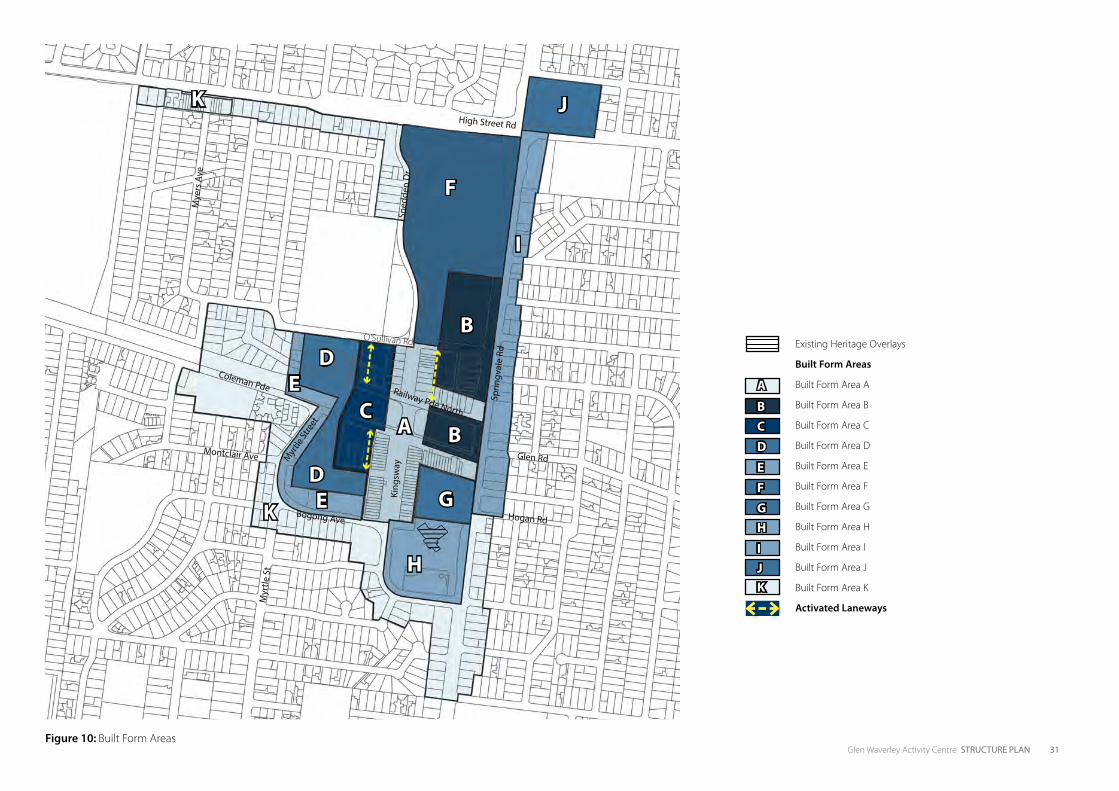
Glen Waverley Activity Centre STRUCTURE PLAN 31Figure 10: Built Form Areas
Existing Heritage Overlays
Built Form Areas
Built Form Area A
Built Form Area B
Built Form Area C
Built Form Area D
Built Form Area E
Built Form Area F
Built Form Area G
Built Form Area H
Built Form Area I
Built Form Area J
Built Form Area K
Activated Laneways
A
BCD
EFGH
IJK
High Street Rd
Glen Rd
Bogong Ave
Coleman Pde Railway Pde North
Myr
tle St
reet
O’Sullivan Rd
Montclair Ave
Sprin
gval
e Rd
King
sway
Sned
den
Dr
Mye
rs A
ve
Myr
tle S
t
A
B
BC
D
F
G
H
I
JK
DE
E
K Hogan Rd

32 Glen Waverley Activity Centre STRUCTURE PLAN
Glazed ground floors with podium built to the street edge contributes to street vitality. Tower forms set back above podium
Fine-grain street frontages support an active Kingsway precinctInteractive facades and glazed openings in upper podium levels provide opportunities for passive surveillance of the public realm
Street facing townhouse residences with towers set back from podium edge
Area I• Opportunity for 4-6 storeys
• Ground level front setbacks of 5m with active frontages
• Buildings to scale down to adjoining residential interfaces. Rear setbacks in accordance with ResCode
Area J• Opportunity for 4-8 storeys
• Ground level front setbacks of 5m and active frontages to Springvale Road and High Street Road
• Buildings to scale down to adjoining residential interfaces. Rear setbacks in accordance with ResCode
Area K• Opportunity for 3-4 storeys.
• Front setbacks of at least 5m and side and rear setbacks in accordance with ResCode
• Zero front and side setback for shops between 678 and 710 High Street Road
Glen Waverley Activity Centre STRUCTURE PLAN 33
ActionsF.1 Undertake a planning scheme amendment to implement the
built form recommendations to ensure that public realm is protected and that new development of high architectural quality is achieved throughout the GWAC
F.2 Develop planning measures which aim to retain the existing fine grain character of commercial buildings along Kingsway within the GWAC and ensure new buildings in key streets are articulated to reflect the pattern of narrow shopfronts
F.3 Require new buildings to be easily accessible by pedestrians regardless of their level of mobility
F.4 Require ESD features to be incorporated into building designs in accordance with best practice
F.5 Work with the State Government to undertake an audit of infrastructure within the GWAC and work with service providers, as required, to ensure that infrastructure is adequate to meet future growth within the Activity Centre
F.6 Require new development proposals over 6 storeys to demonstrate how the effects of wind down-draughts, caused by the development, will be avoided or mitigated at street level. On higher proposed buildings, especially where the proposed height represents a significant change from the surrounding environment, Council should consider requiring verification of wind effects by specialist wind modelling and engineering consultants
F.7 Council to develop strategies and policies to facilitate development that supports the objectives of the GWAC Structure Plan. Mechanisms could include land swaps, development partnerships and providing incentives, such as height increases, for development proposals that demonstrate excellence in design quality, ESD, social equity and/or positive contributions to the public realm
F.8 Apply setbacks to the proposed ring road to allow for future road widening and street tree planting
F.9 Consider the development of built form and public realm design guidelines for new development within the GWAC to ensure that design excellence is achieved on all sites. The guidelines should focus on site layout and landscape, design detail, materials and finishings, street interface, design of key sites, access and servicing, sustainability and amenity
34 Glen Waverley Activity Centre STRUCTURE PLAN
4.3 PUBLIC REALMThe Vision aims to provide streets and public spaces that are inspiring and people oriented. This theme provides initiatives on how the public realm should respond to the needs of the community. Figure 11 reflects the future public realm recommendations.
G. STREETSCAPESThe streets within the GWAC are key public spaces that define the character of Glen Waverley and provide the vehicle for street life. Providing great streets that are focused on the experience of people is key to the vitality of the centre.
There is a significant opportunity to revisit the role of the streets in the GWAC and provide a shift from car dominated streets to active streets where pedestrians and cyclists have a high priority. In particular Kingsway currently devotes 72% of its total road space to car movement and parking, and only 28% to pedestrians and cyclists. This balance needs to addressed in Kingsway and other streets in order to enhance street life in the GWAC.
A cohesive pallette of street treatments including paving, furniture and planting will also be key in enhancing the image and function of the GWAC. This will help to define the role and hierarchy of streets within the centre.
Another opportunity identified in the Structure Plan is to create a green edge to the centre with a boulevard character to the proposed ring road. This will create a strong edge to the GWAC commercial area, provide pleasant spaces for pedestrians and play a key environmental role through the implementation of water sensitive urban design measures.
ObjectiveTo provide streets throughout the GWAC that are full of life, green and contribute to the economic and social vitality of the centre
Strategies• Improve the key streets within the GWAC commercial area
to strengthen pedestrians and cyclists priority, provide additional greening, create a cohesive image and define a clear hierarchy of spaces
• Define a green, enveloping edge to the GWAC commercial area through large tree planting and landscaping along the future Ring Road
• Improve entries into the GWAC by providing additional planting, landscaping, public art and high quality built form along main roads
• Enhance key residential streets that connect into the town centre to encourage walking and promote healthy lifestyles
• Provide for continual weather protection along key streets within the GWAC commercial area
• Ensure streets are well lit and provide a safe environment for all users
• Ensure streetscape improvements employ sustainable practices such as innovative water conservation, harvest and reuse strategies in their design
• Provide opportunities to actively generate energy in the public realm
• Pursue opportunities for public art throughout the GWAC which contributes to the local identity and sense of place
ActionsG.1 Develop a Streetscape Master Plan for the GWAC that:
• Identifies a clear hierarchy of GWAC commercial area streets with a suite of materials, planting and furniture for each street
• Identifies a planting scheme for the future Ring Road with large scale trees, low level planting in nature strips and medians and provision of consistent footpath width and treatment
• Identifies improvements to the key residential access streets identified in Figure 11 with a focus on street tree planting for shade, lower level landscaping, footpath quality and width and pedestrian priority at intersections
• Provides for a staged implementation of streetscape improvements in accordance with the implementation of the Ring Road
• Identifies improvements to key arterial roads and key entries into the GWAC
• Integrates an integrated WSUD strategy to provide for water treatment and passive irrigation of trees and planting
• Review the landscaping directions within streetscapes to ensure high quality indigenous vegetation is used where feasible
G.2 Develop a co-ordinated lighting strategy which focuses on illuminatination of streets and other public spaces and the use of feature lighting to emphasise key features
G.3 Develop planning measures that require the provision of building awnings in the locations identified as weather protection areas
G.4 Undertake a Crime Prevention Through Environmental Design (CPTED) audit of the GWAC
G.5 Develop a suite of public furniture with a palette that enhances the identity of the GWAC.
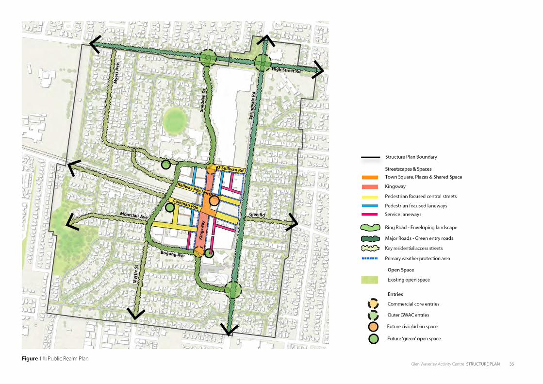
Glen Waverley Activity Centre STRUCTURE PLAN 35Figure 11: Public Realm Plan
High Street Rd
Glen Rd
Bogong Ave
Coleman Pde
Railway Pde North
O’Sullivan Rd
Montclair Ave
Spri
ngva
le R
d
King
sway
Sned
den
Dr
Mye
rs A
ve
Myr
tle
St
36 Glen Waverley Activity Centre STRUCTURE PLAN
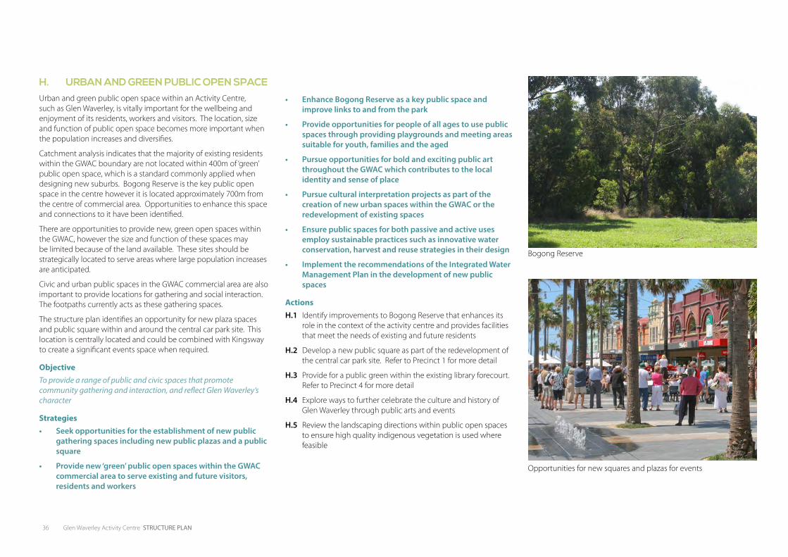
H. URBAN AND GREEN PUBLIC OPEN SPACEUrban and green public open space within an Activity Centre, such as Glen Waverley, is vitally important for the wellbeing and enjoyment of its residents, workers and visitors. The location, size and function of public open space becomes more important when the population increases and diversifies.
Catchment analysis indicates that the majority of existing residents within the GWAC boundary are not located within 400m of ‘green’ public open space, which is a standard commonly applied when designing new suburbs. Bogong Reserve is the key public open space in the centre however it is located approximately 700m from the centre of commercial area. Opportunities to enhance this space and connections to it have been identified.
There are opportunities to provide new, green open spaces within the GWAC, however the size and function of these spaces may be limited because of the land available. These sites should be strategically located to serve areas where large population increases are anticipated.
Civic and urban public spaces in the GWAC commercial area are also important to provide locations for gathering and social interaction. The footpaths currently acts as these gathering spaces.
The structure plan identifies an opportunity for new plaza spaces and public square within and around the central car park site. This location is centrally located and could be combined with Kingsway to create a significant events space when required.
ObjectiveTo provide a range of public and civic spaces that promote community gathering and interaction, and reflect Glen Waverley’s character
Strategies• Seek opportunities for the establishment of new public
gathering spaces including new public plazas and a public square
• Provide new ‘green’ public open spaces within the GWAC commercial area to serve existing and future visitors, residents and workers
• Enhance Bogong Reserve as a key public space and improve links to and from the park
• Provide opportunities for people of all ages to use public spaces through providing playgrounds and meeting areas suitable for youth, families and the aged
• Pursue opportunities for bold and exciting public art throughout the GWAC which contributes to the local identity and sense of place
• Pursue cultural interpretation projects as part of the creation of new urban spaces within the GWAC or the redevelopment of existing spaces
• Ensure public spaces for both passive and active uses employ sustainable practices such as innovative water conservation, harvest and reuse strategies in their design
• Implement the recommendations of the Integrated Water Management Plan in the development of new public spaces
ActionsH.1 Identify improvements to Bogong Reserve that enhances its
role in the context of the activity centre and provides facilities that meet the needs of existing and future residents
H.2 Develop a new public square as part of the redevelopment of the central car park site. Refer to Precinct 1 for more detail
H.3 Provide for a public green within the existing library forecourt. Refer to Precinct 4 for more detail
H.4 Explore ways to further celebrate the culture and history of Glen Waverley through public arts and events
H.5 Review the landscaping directions within public open spaces to ensure high quality indigenous vegetation is used where feasible
Bogong Reserve
Opportunities for new squares and plazas for events
Glen Waverley Activity Centre STRUCTURE PLAN 37
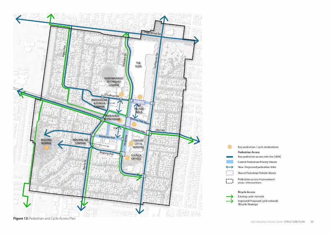
4.4 MOVEMENT AND TRANSPORTThe Vision seeks to create a connected Glen Waverley where pedestrians and cyclists have priority on key streets and residents and workers can easily access the GWAC’s shops, services and public transport. This theme outlines initiatives for achieving an integrated transport network across all modes - walking, cycling, public transport and vehicles. Figure 12 and 13 reflects the future access recommendations across the GWAC.
I. WALKING AND CYCLINGThe GWAC is currently a car dominated centre. The allocation of road space to pedestrians and cyclists is minimal and there is a lack of pedestrian priority at key intersections. There is an opportunity to imagine a different future for the GWAC where walking and cycling is easy and enjoyable, and the preferred mode of transport for residents, visitors and workers. This will provide major health, environmental and social benefits across the GWAC and help to create vibrant streets, improve safety and surveillance, and strengthen businesses.
The Structure Plan proposes numerous footpath widenings along Kingsway, a number of pedestrian plaza spaces, pedestrian priority crossings at key intersections, as well as shared pedestrian and vehicle zones. All of these initiatives contribute to a clear network of streets within the commercial area where walking and cycling is prioritised.
Walking and cycling connections from surrounding residential areas into the GWAC commercial area are also important. Several links have been identified where additional shade will be provided, continuous and generous footpaths, good lighting, as well as cycle lanes. This will make it easier for residents to move between their homes and key destinations across the centre.
ObjectiveTo prioritise walking and cycling across the GWAC with a convenient, comfortable, safe and connected network
Strategies• Provide a high level of pedestrian and cycle priority on
all streets within the GWAC commercial area
• Reduce vehicle speeds and provide traffic calming along the key Central Pedestrian Priority Streets
• Enhance existing laneways and pedestrian arcades through the provision of improved street lighting, improved surfacing and active surveillance
• Improve pedestrian amenity and priority along key streets that connect the town centre into surrounding residential areas
• Strengthen pedestrian links between the railway station, bus interchange, Glen Waverley Secondary School and Kingsway
• Provide cycle routes across the GWAC commercial area and into existing cycle networks
• Provide access for all levels of mobility through DDA compliance in all public realm works
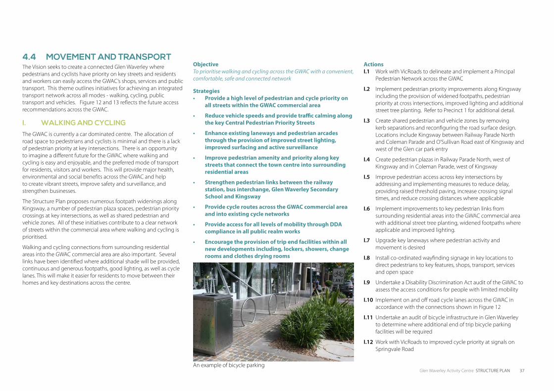
• Encourage the provision of trip end facilities within all new developments including, lockers, showers, change rooms and clothes drying rooms
ActionsI.1 Work with VicRoads to delineate and implement a Principal
Pedestrian Network across the GWAC
I.2 Implement pedestrian priority improvements along Kingsway including the provision of widened footpaths, pedestrian priority at cross intersections, improved lighting and additional street tree planting. Refer to Precinct 1 for additional detail.
I.3 Create shared pedestrian and vehicle zones by removing kerb separations and reconfiguring the road surface design. Locations include Kingsway between Railway Parade North and Coleman Parade and O’Sullivan Road east of Kingsway and west of the Glen car park entry
I.4 Create pedestrian plazas in Railway Parade North, west of Kingsway and in Coleman Parade, west of Kingsway
I.5 Improve pedestrian access across key intersections by addressing and implementing measures to reduce delay, providing raised threshold paving, increase crossing signal times, and reduce crossing distances where applicable
I.6 Implement improvements to key pedestrian links from surrounding residential areas into the GWAC commercial area with additional street tree planting, widened footpaths where applicable and improved lighting.
I.7 Upgrade key laneways where pedestrian activity and movement is desired
I.8 Install co-ordinated wayfinding signage in key locations to direct pedestrians to key features, shops, transport, services and open space
I.9 Undertake a Disability Discrimination Act audit of the GWAC to assess the access conditions for people with limited mobility
I.10 Implement on and off road cycle lanes across the GWAC in accordance with the connections shown in Figure 12
I.11 Undertake an audit of bicycle infrastructure in Glen Waverley to determine where additional end of trip bicycle parking facilities will be required
I.12 Work with VicRoads to improved cycle priority at signals on Springvale Road
An example of bicycle parking
38 Glen Waverley Activity Centre STRUCTURE PLAN
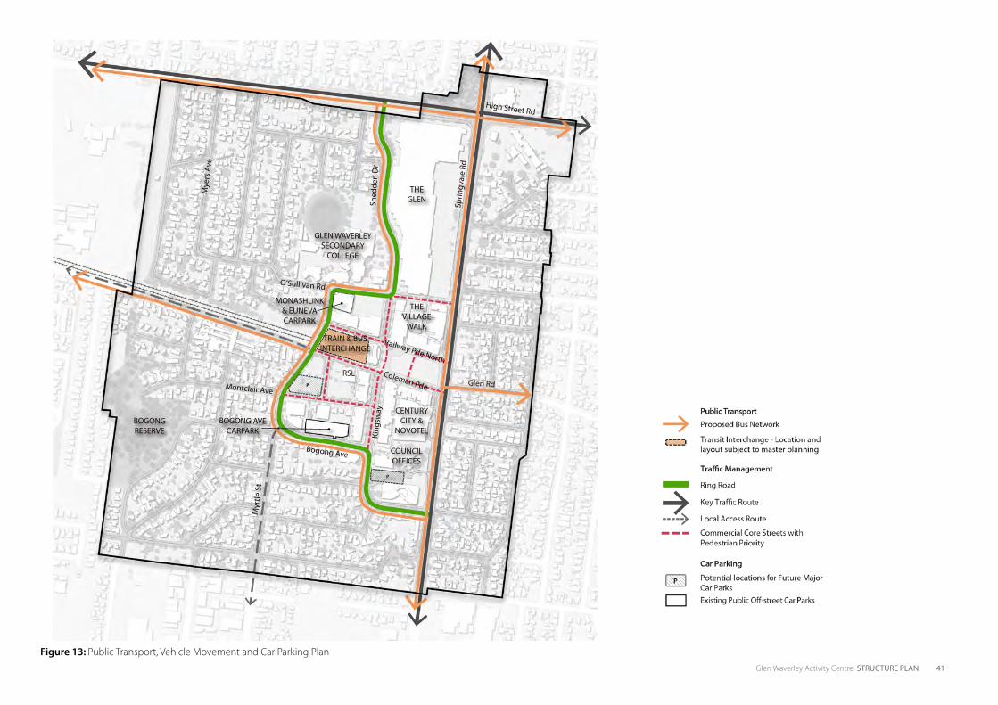
J. PUBLIC TRANSPORTThe train station and bus interchange is the major public transport facility in the GWAC and it is centrally located in close proximity to the shopping strips, The Glen, Glen Waverley Secondary College, Century City Walk, hotels, the Civic Centre and surrounding residential areas.
Access to the train station will be improved with a new east west pedestrian connection through the IKON development, which will create a significant arrival point into Kingsway. Planned beautification works to the station will also enhance it as a place for people.
The GWAC has excellent bus services providing ten key routes and one smart bus route from the current interchange. The interchange, however, provides a poor quality environment for pedestrians and presents poorly to the surrounding streets. Additional landscaping and improved safety for pedestrians at crossing points could be provided in the short term to enhance the bus interchange as a key destination in the GWAC.
Opportunities also exist to improve access between interchange and station, and the Glen Waverley Secondary School as this is a major pedestrian desire line. Improvement to the laneway behind the Dan Murphys building will play a key role in strengthening this connection as will the provision of a raised pedestrian crossing on Railway Parade North, adjacent to the interchange.
The train station and bus interchange should form part of a long term master plan, which tests a number of scenarios for its relocation and re-configuration, and tests opportunities for development of the airspace above the precinct. Any master plan for the precinct should enable the implementation of the Ring Road and provide for better integration of the interchange into the surrounding street network.
ObjectiveTo support integrated public transport as an attractive and logical choice for accessing the GWAC.
Strategies• Improve public transport frequency, integration,
comfort and amenity in order to promote public transport as a desirable transport alternative
• Support bus priority at key intersections within the GWAC
• Improve the bus interchange to provide a safer and higher amenity environment for pedestrians and provide better integration with the surrounding streets
• Encourage the redevelopment of the train station and bus interchange to achieve a high quality, integrated interchange that enables the development of the Ring Road
• Enhance the pedestrian connection between the Glen Waverley Secondary College and the interchange
• Decrease the need for vehicles through the Activity Centre by enhancing the accessibility to car parking facilities from Springvale Road and the proposed Ring Road
ActionsRefer to Precinct 3 for more detailed actions regarding the transit interchange precinct
J.1 Work with VicTrack in developing a vision and master plan for the transit interchange precinct. Refer to Precinct 3 for additional detail
J.2 Advocate for improved services and connection between bus and rail systems
J.3 Work with VicTrack and bus operators in developing a suite of improvements to the bus interchange with a focus on improving pedestrian amenity and safety
K. TRAFFIC MANAGEMENTAlthough the structure plan encourages a shift to more sustainable and active modes of transport such as walking and cycling, it is recognised that vehicles will continue to play a key role in providing access to businesses and services in the GWAC.
The traffic analysis has identified that many vehicles are using Kingsway as a through route to bypass Springvale Road. This traffic has negative implications on key streets such as Kingsway as it causes congestion and makes it a less pleasant and less safe environment for pedestrians and cyclists.
The Structure Plan proposes a Ring Road that will aim to reduce through traffic on key town centre streets such as Kingsway. The Ring Road will provide convenient access to major car parking facilities and businesses thereby minimising the need for vehicles to use the key town centre streets. The space currently allocated to vehicles on town centre streets such as Kingsway will be narrowed and increased for pedestrians and cyclists.
A staged approach is proposed to the implementation of the Ring Road. Each stage will provide improvements to the town centre by creating larger walking and gathering spaces for people and reducing through traffic. The proposed staging plan is outlined in this section.
ObjectivesTo provide a clear and logical vehicle network and hierarchy in the GWAC whilst encouraging a shift to other modes of transport.
Strategies• Implement the proposed Ring Road in a staged
approach to reduce vehicle traffic on key streets in the GWAC commercial area
• Encourage new development to provide access to car parks and be serviced from rear laneways where they exist to minimise vehicle crossovers and movements on key streets
ActionsK.1 Develop a staging strategy for the implementation of the Ring
Road and begin to implement the first stage
BOGONG RESERVE
CENTURY CITY &
NOVOTEL
COUNCIL OFFICES
THE VILLAGE
WALK
GLEN WAVERLEY SECONDARY
COLLEGE
THE GLEN
RSL
BOGONG AVE CARPARK
TRAIN & BUS INTERCHANGE
MONASHLINK & EUNEVA CARPARK
Glen Waverley Activity Centre STRUCTURE PLAN 39Figure 12: Pedestrian and Cycle Access Plan
High Street Rd
Glen Rd
Bogong Ave
Coleman Pde
Railway Pde North
O’Sullivan Rd
Montclair Ave
Sprin
gval
e Rd
King
sway
Sned
den
Dr
Mye
rs A
ve
Myr
tle S
t

40 Glen Waverley Activity Centre STRUCTURE PLAN
L. CAR PARKINGThere are a total of 2,301 parking spaces available within the GWAC study area with an additional 3,138 spaces available within The Glen. Of the 2,301 parking spaces available within the study area 316 spaces are located on-street with the remaining 1,985 spaces located off-street.
The peak for parking demand across the GWAC occurs between 12:30 and 1:00pm with a peak occupancy of 82.3%. A secondary peak is experienced in the evening between 8:00 and 8:30pm with an overall occupancy of 77%. On this basis, it is considered that the overall parking supply within the centre is appropriate to accommodate the peak demands for parking.
The parking analysis does reveal however that certain car parking precincts are nearing capacity while others are relatively underutilised. Therefore it is important that future car parking is strategically located to relate to the level of activity, is easy to find from key vehicle access roads and there are activated, safe and convenient pedestrian links between the car park and the shops.
The increased pedestrianisation of key streets such as Kingsway will result in small reductions to on-street car parking. Similarly a number of the existing at-grade car parking will be redeveloped for higher order uses.
The approach is to replace this car parking in large car parking structures that are strategically located close to activity and can be easily accessed from the proposed Ring Road. It will be important to provide safe and convenient pedestrian access from these structures into the shopping streets.
Parking time restrictions are used across the GWAC to encourage motorists who want to park for long periods, to use car parks further away from the highest demand areas, leaving the closest spaces available for short stay customer parking. While parking time restrictions may be inconvenient at times, their application ensures that motorists have a more equal opportunity to park their vehicle close to their destination. Parking time restrictions therefore support strong and profitable local business and employment.
ObjectiveTo provide car parking that is easy to find and access with minimal disruption to walkers, cyclists and public transport
Strategies• Locate new car parking facilities at strategic locations
within the GWAC that can be accessed from the proposed Ring Road and provide for safe and convenient pedestrian connections to the shops
• Provide for greater use of existing Council and privately operated off street car parks in order to reduce vehicle movements on key pedestrian priority streets
• Provide safe and convenient pedestrian access to existing off-street car parks
ActionsL.1 Concentrate urban improvement efforts on making the
pedestrian experience convenient and attractive to / from the Euneva Avenue Car Park through lighting, signage, landscaping and requiring active frontages in new developments
L.2 Investigate the use of dynamic signage across the GWAC that provides live information about car parking occupancy
L.3 Undertake an audit of existing Council owned car parks to ensure they have adequate directional signage, are well lit and can be safely accessed by pedestrians
L.4 Develop a policy that seeks to encourage and promote the installation of car share parking and use with GWAC
L.5 Investigate the inclusion of electric vehicle re charge points in new car park designs
L.6 Review the implementation of a paid parking scheme with GWAC on a regular basis
L.7 Investigate Park and Ride facilities in conjunction with VicTrack, Department of Transport Planning and Local Infrastructure and Metropolitan Planning Authority to encourage more commuters to access the Glen Waverley Station by bus
The Euneva Street car park
L.8 Develop a policy that seeks to provide a reduced car parking provision for office developments within the GWAC that provide a sustainable transport plan
L.9 Develop a policy that allows flexibility with regards to the allocation of residential parking in new developments having regard to the Glen Waverley Activity Centre Sustainable Transport Plan
Glen Waverley Activity Centre STRUCTURE PLAN 41
Figure 13: Public Transport, Vehicle Movement and Car Parking Plan
BOGONG RESERVE
CENTURY CITY &
NOVOTEL
COUNCIL OFFICES
THE VILLAGE
WALK
GLEN WAVERLEY SECONDARY
COLLEGE
THE GLEN
RSL
BOGONG AVE CARPARK
TRAIN & BUS INTERCHANGE
MONASHLINK & EUNEVA CARPARK
High Street Rd
Glen Rd
Bogong Ave
Coleman Pde
Railway Pde North
O’Sullivan Rd
Montclair Ave
Sprin
gval
e Rd
King
sway
Sned
den
Dr
Mye
rs A
ve
Myr
tle S
t
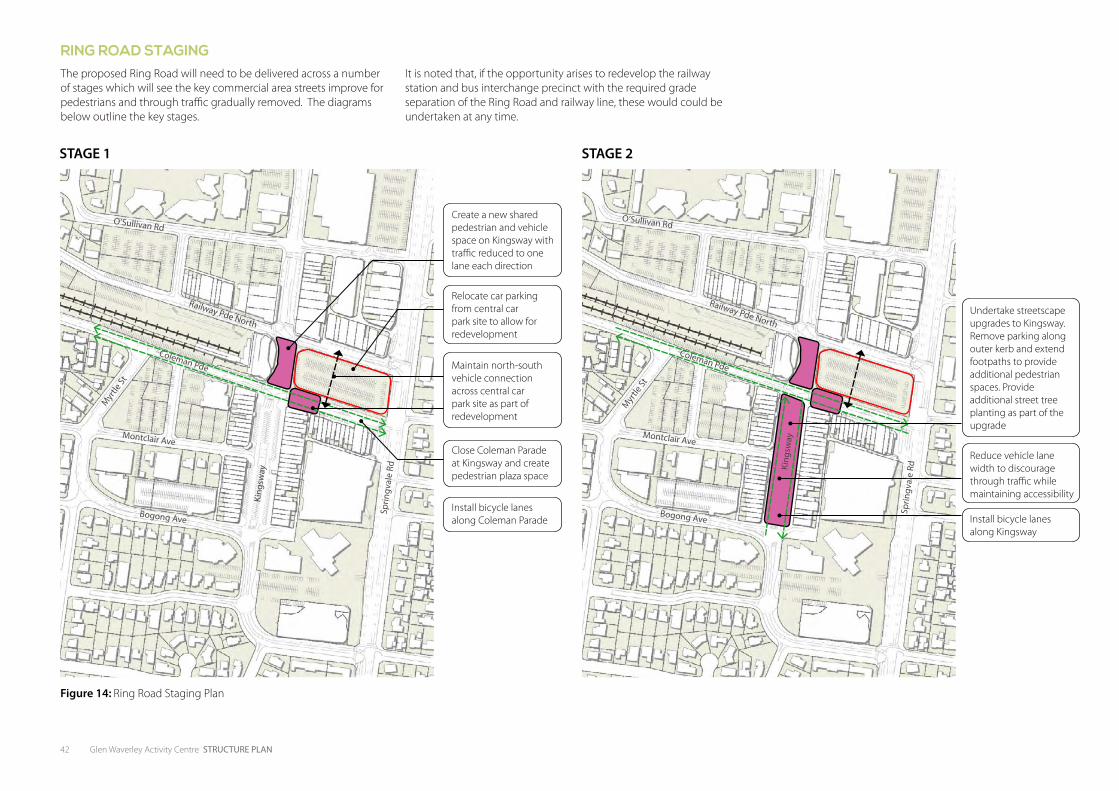
42 Glen Waverley Activity Centre STRUCTURE PLAN
Figure 14: Ring Road Staging Plan
O’Sullivan Rd
Bogong Ave
Montclair Ave
King
sway
Sprin
gval
e Rd
Myr
tle St
Coleman Pde
Railway Pde North
STAGE 1 STAGE 2
Relocate car parking from central car park site to allow for redevelopment
Create a new shared pedestrian and vehicle space on Kingsway with traffic reduced to one lane each direction
Undertake streetscape upgrades to Kingsway. Remove parking along outer kerb and extend footpaths to provide additional pedestrian spaces. Provide additional street tree planting as part of the upgrade
Reduce vehicle lane width to discourage through traffic while maintaining accessibility
Install bicycle lanes along Kingsway
Close Coleman Parade at Kingsway and create pedestrian plaza space
Install bicycle lanes along Coleman Parade
Maintain north-south vehicle connection across central car park site as part of redevelopment
RING ROAD STAGINGThe proposed Ring Road will need to be delivered across a number of stages which will see the key commercial area streets improve for pedestrians and through traffic gradually removed. The diagrams below outline the key stages.
O’Sullivan Rd
Bogong Ave
Montclair Ave
King
sway
Sprin
gval
e Rd
Myr
tle St
Coleman Pde
Railway Pde North
It is noted that, if the opportunity arises to redevelop the railway station and bus interchange precinct with the required grade separation of the Ring Road and railway line, these would could be undertaken at any time.
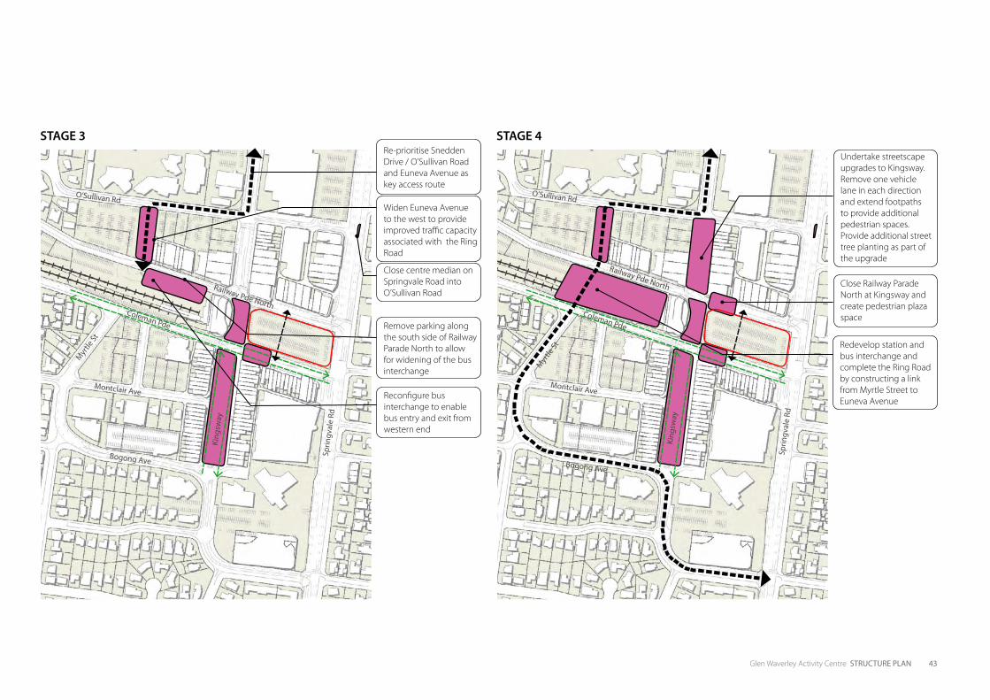
Glen Waverley Activity Centre STRUCTURE PLAN 43
STAGE 3 STAGE 4
Reconfigure bus interchange to enable bus entry and exit from western end
Redevelop station and bus interchange and complete the Ring Road by constructing a link from Myrtle Street to Euneva Avenue
Remove parking along the south side of Railway Parade North to allow for widening of the bus interchange
Close centre median on Springvale Road into O’Sullivan Road
Re-prioritise Snedden Drive / O’Sullivan Road and Euneva Avenue as key access route
Widen Euneva Avenue to the west to provide improved traffic capacity associated with the Ring Road
Close Railway Parade North at Kingsway and create pedestrian plaza space
Undertake streetscape upgrades to Kingsway. Remove one vehicle lane in each direction and extend footpaths to provide additional pedestrian spaces. Provide additional street tree planting as part of the upgrade
O’Sullivan Rd
Bogong Ave
Montclair Ave
King
sway
Sprin
gval
e Rd
Myr
tle St
Coleman Pde
Railway Pde North
O’Sullivan Rd
Bogong Ave
Montclair Ave
King
sway
Sprin
gval
e Rd
Myr
tle St
Coleman Pde
Railway Pde North

44 Glen Waverley Activity Centre STRUCTURE PLAN
This page has been left blank intentionally

5PRECINCT PLANS

46 Glen Waverley Activity Centre STRUCTURE PLAN
This page has been left blank intentionally
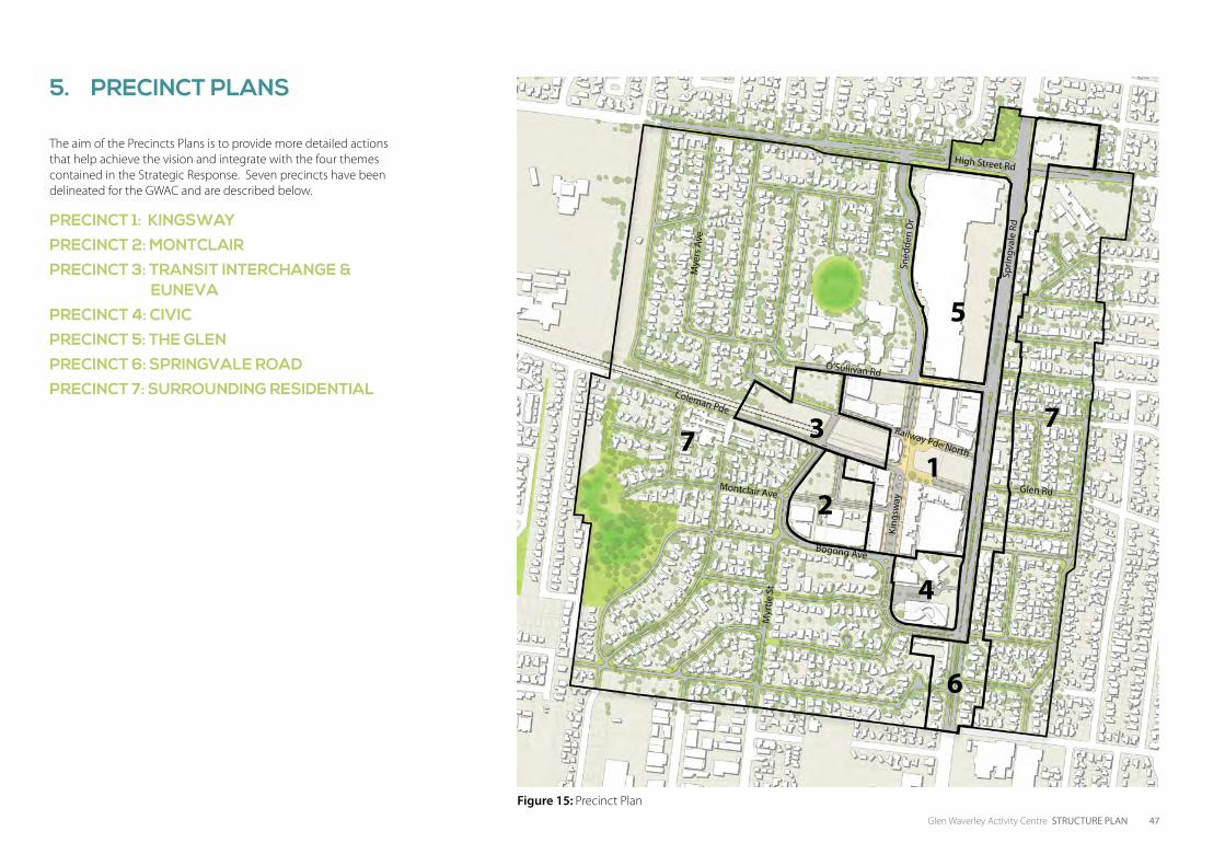
Glen Waverley Activity Centre STRUCTURE PLAN 47
The aim of the Precincts Plans is to provide more detailed actions that help achieve the vision and integrate with the four themes contained in the Strategic Response. Seven precincts have been delineated for the GWAC and are described below.
PRECINCT 1: KINGSWAY
PRECINCT 2: MONTCLAIR
PRECINCT 3: TRANSIT INTERCHANGE & EUNEVA
PRECINCT 4: CIVIC
PRECINCT 5: THE GLEN
PRECINCT 6: SPRINGVALE ROAD
PRECINCT 7: SURROUNDING RESIDENTIAL
12
3
4
5
6
77
Figure 15: Precinct Plan
High Street Rd
Glen Rd
Bogong Ave
Coleman Pde
Railway Pde North
O’Sullivan Rd
Montclair Ave
Sprin
gval
e Rd
King
sway
Sned
den
Dr
Mye
rs A
ve
Myr
tle S
t
5. PRECINCT PLANS
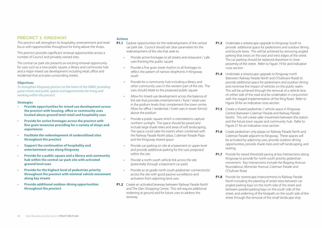
48 Glen Waverley Activity Centre STRUCTURE PLAN
PRECINCT 1: KINGSWAY This precinct will strengthen its hospitality, entertainment and retail focus with opportunities throughout for living above the shops.
This precinct provides significant renewal opportunities across a number of Council and privately owned sites.
The central car park site presents an exciting renewal opportunity for uses such as a new public square, a library and community hub and a major mixed use development including retail, office and residential that activates surrounding streets.
ObjectivesTo strengthen Kingsway precinct as the heart of the GWAC providing great streets and public spaces and opportunities for living and working within the precinct
Strategies• Provide opportunities for mixed use development across
the precinct with housing, office or community uses located above ground level retail and hospitality uses
• Provide for active frontages across the precinct with fine grain tenancies providing for a variety of shops and experiences
• Facilitate the redevelopment of underutilised sites throughout the precinct
• Support the continuation of hospitality and entertainment uses along Kingsway
• Provide for a public square and a library and community hub within the central car park site with activated ground level uses
• Provide for the highest level of pedestrian priority throughout the precinct with minimal vehicle movement along key streets
• Provide additional outdoor dining opportunities throughout the precinct
ActionsP1.1 Explore opportunities for the redevelopment of the central
car park site. Council should set clear parameters for the redevelopment of the site that seek to:
• Provide active frontages to all streets and restaurant / cafe uses fronting the public square
• Provide a fine grain street rhythm to all frontages to reflect the pattern of narrow shopfronts in Kingsway south
• Provide for a community hub including a library and other community uses in the western part of the site. The uses should relate to the proposed public square
• Allow for mixed use development across the balance of the site that provides entertainment / food / retail uses in the podium levels that complement the town centre. Allow for office / residential / hotel uses in tower form(s) above the podium
• Provide a public square which is orientated to capture northern sunlight. The space should be paved and include large shade trees and areas of soft landscaping. The space could cater for events when combined with the Railway Parade North plaza, Coleman Parade Plaza and the Kingsway shared space
• Provide car parking on site at a basement or upper level and provide additional parking for the uses proposed within the site
• Provide a north-south vehicle link across the site (potentially through a basement car park)
• Provide an at-grade north-south pedestrian connection(s) across the site with good passive surveillance and activation from adjoining land uses
P1.2 Create an activated laneway between Railway Parade North and The Glen Shopping Centre. This will require additional widening at ground and for future uses to address the laneway
P1.3 Undertake a streetscape upgrade to Kingsway South to provide additional space for pedestrians and outdoor dining and bicycle lanes. This will be achieved by removing angled parking that exists on the east and west edges of the street. The car parking should be replaced elsewhere in close proximity of the street. Refer to Figure 19 for and indicative cross section
P1.4 Undertake a streetscape upgrade to Kingsway north (between Railway Parade North and O’Sullivans Road) to provide additional space for pedestrians and outdoor dining and minimise the impact of vehicles on the public realm. This will be achieved through the removal of a vehicle lane on either side of the road and be undertaken in conjunction with the staged implementation of the Ring Road. Refer to Figure 20 for an indicative cross section
P1.5 Create a shared pedestrian / vehicle space in Kingsway Central (between Coleman Parade and Railway Parade North). This will create safer movement between the station and the future town square and community hub. Refer to Figure 21 for an indicative cross section
P1.6 Create pedestrian only plazas on Railway Parade North and Coleman Parade adjacent to Kingsway. These spaces will be activated by adjoining uses, provide outdoor dining opportunities, provide shade trees and soft landscaping, and seating.
P1.7 Provide for raised threshold paving at key intersections along Kingsway to provide for north-south priority pedestrian movement. Key intersections include the Bogong Avenue Roundabout, Montclair Avenue, Coleman Parade and O’Sullivan Road
P1.8 Provide for streetscape improvements to Railway Parade North including the planting of street trees between car angled parking bays on the north side of the street and between parallel parking bays on the south side of the street, and widening of the footpath on the south side of the street through the removal of the small landscape strip
P1. ff
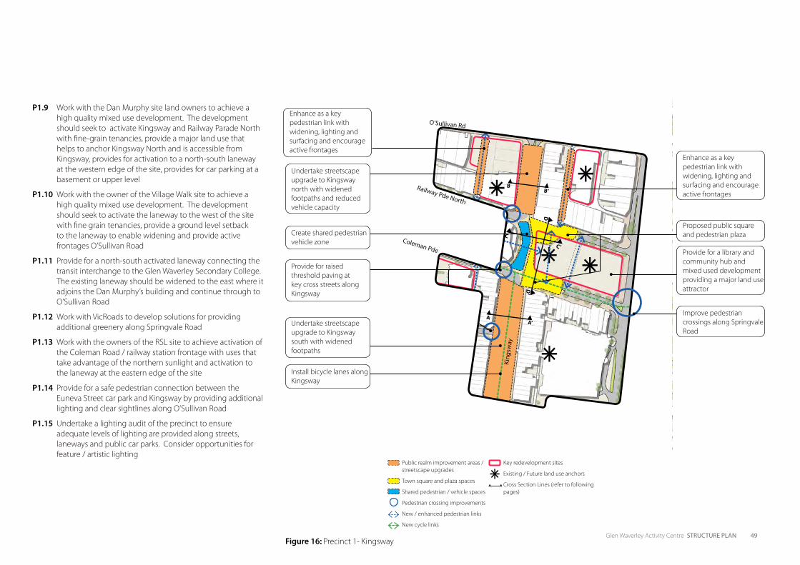
Glen Waverley Activity Centre STRUCTURE PLAN 49
P1.9 Work with the Dan Murphy site land owners to achieve a high quality mixed use development. The development should seek to activate Kingsway and Railway Parade North with fine-grain tenancies, provide a major land use that helps to anchor Kingsway North and is accessible from Kingsway, provides for activation to a north-south laneway at the western edge of the site, provides for car parking at a basement or upper level
P1.10 Work with the owner of the Village Walk site to achieve a high quality mixed use development. The development should seek to activate the laneway to the west of the site with fine grain tenancies, provide a ground level setback to the laneway to enable widening and provide active frontages O’Sullivan Road
P1.11 Provide for a north-south activated laneway connecting the transit interchange to the Glen Waverley Secondary College. The existing laneway should be widened to the east where it adjoins the Dan Murphy’s building and continue through to O’Sullivan Road
P1.12 Work with VicRoads to develop solutions for providing additional greenery along Springvale Road
P1.13 Work with the owners of the RSL site to achieve activation of the Coleman Road / railway station frontage with uses that take advantage of the northern sunlight and activation to the laneway at the eastern edge of the site
P1.14 Provide for a safe pedestrian connection between the Euneva Street car park and Kingsway by providing additional lighting and clear sightlines along O’Sullivan Road
P1.15 Undertake a lighting audit of the precinct to ensure adequate levels of lighting are provided along streets, laneways and public car parks. Consider opportunities for feature / artistic lighting
Public realm improvement areas / streetscape upgrades
Town square and plaza spaces
Shared pedestrian / vehicle spaces
Pedestrian crossing improvements
New / enhanced pedestrian links
New cycle links
Key redevelopment sites
Existing / Future land use anchors
Cross Section Lines (refer to following pages)
Figure 16: Precinct 1- Kingsway
A
C
D
A’
C’
D’
BB’
King
sway
Provide for a library and community hub and mixed used development providing a major land use attractor
Improve pedestrian crossings along Springvale Road
Proposed public square and pedestrian plaza
Provide for raised threshold paving at key cross streets along Kingsway
Undertake streetscape upgrade to Kingsway south with widened footpaths
Undertake streetscape upgrade to Kingsway north with widened footpaths and reduced vehicle capacity
Create shared pedestrian vehicle zone
Install bicycle lanes along Kingsway
Enhance as a key pedestrian link with widening, lighting and surfacing and encourage active frontages
Enhance as a key pedestrian link with widening, lighting and surfacing and encourage active frontages
O’Sullivan Rd
Coleman Pde
Railway Pde North
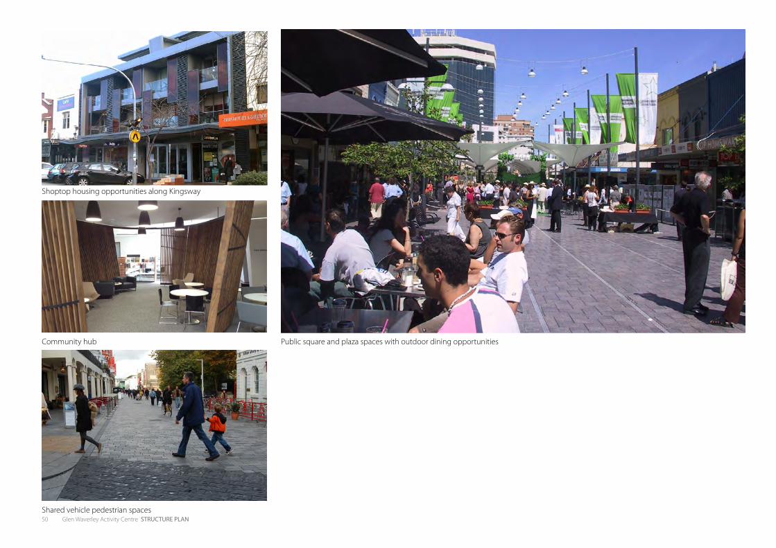
50 Glen Waverley Activity Centre STRUCTURE PLAN
Public square and plaza spaces with outdoor dining opportunities
Shoptop housing opportunities along Kingsway
Community hub
Shared vehicle pedestrian spaces

Glen Waverley Activity Centre STRUCTURE PLAN 51
Figure 17: An artists impression of a potential option for the public square and community hub
Opportunity for large feature tree to anchor town square
Larger scale tower(s)
Coleman Parade Plaza Space
Cafes / restaurants / entertainment uses at ground level providing for day and night activation
Community hub located above cafes / restaurants
Ground level pedestrian connections through the building
Kingsway Shared Space
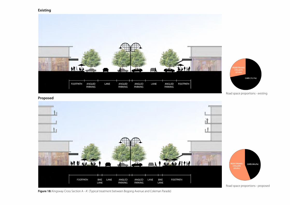
Figure 18: Kingsway Cross Section A - A’ (Typical treatment between Bogong Avenue and Coleman Parade)
Existing
ProposedRoad space proportions - existing
Road space proportions - proposed

Glen Waverley Activity Centre STRUCTURE PLAN 53
Road space proportions - existing
Road space proportions - proposed
Figure 19: Kingsway Cross Section B - B’ (Typical treatment between Railway Parade North and O’Sullivan Road)
Existing Proposed
Road space proportions - existing Road space proportions - proposed
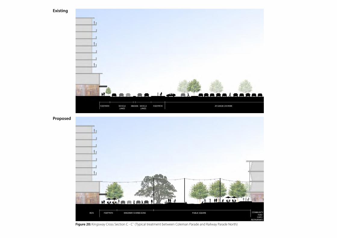
Figure 20: Kingsway Cross Section C - C’ (Typical treatment between Coleman Parade and Railway Parade North)
Existing
Proposed
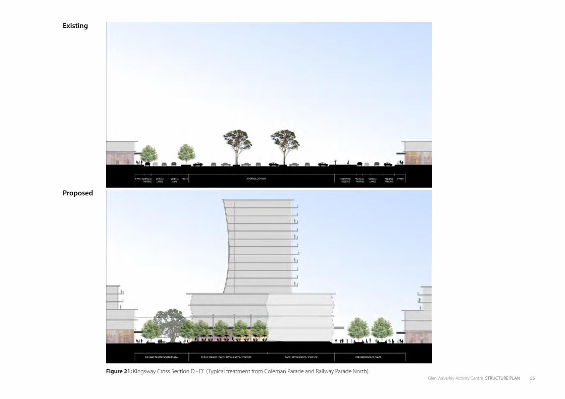
Glen Waverley Activity Centre STRUCTURE PLAN 55Figure 21: Kingsway Cross Section D - D’ (Typical treatment from Coleman Parade and Railway Parade North)
Existing
Proposed
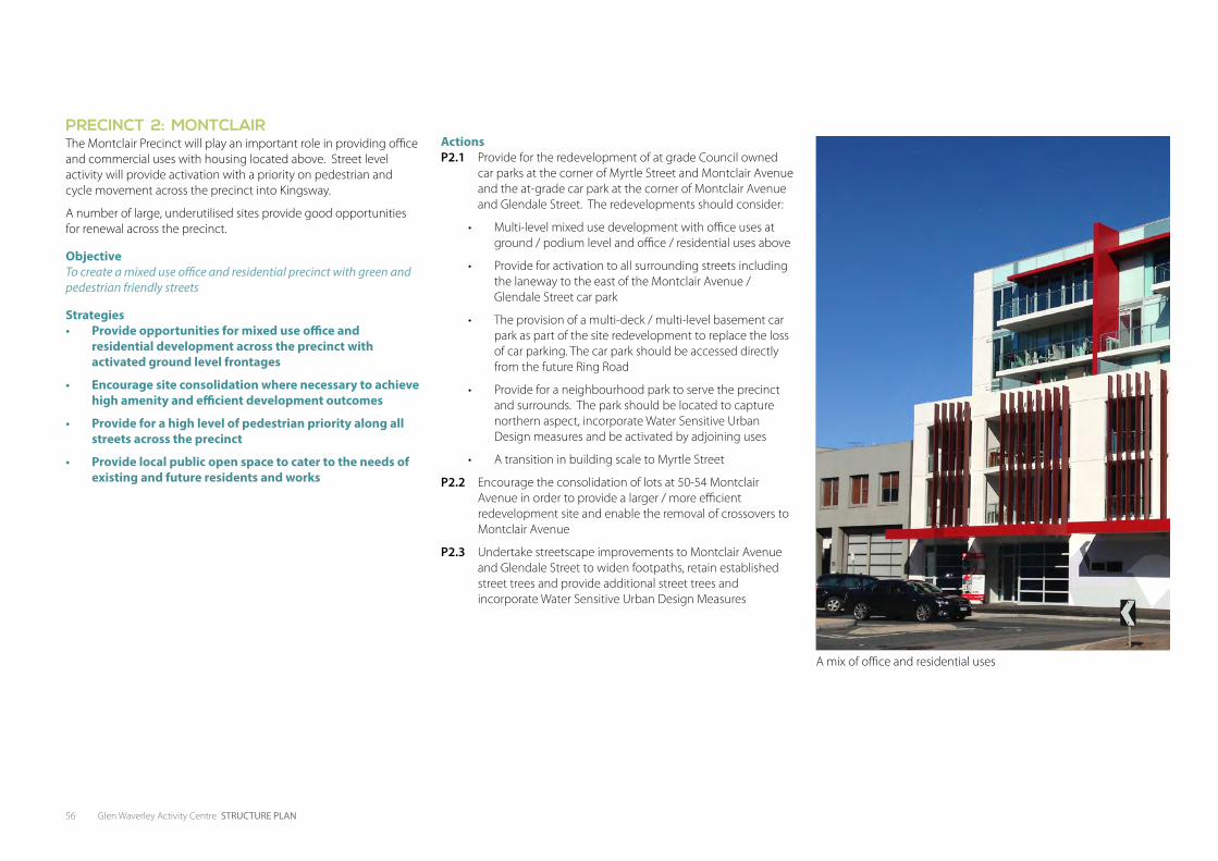
56 Glen Waverley Activity Centre STRUCTURE PLAN
P2. ff
PRECINCT 2: MONTCLAIRThe Montclair Precinct will play an important role in providing office and commercial uses with housing located above. Street level activity will provide activation with a priority on pedestrian and cycle movement across the precinct into Kingsway.
A number of large, underutilised sites provide good opportunities for renewal across the precinct.
ObjectiveTo create a mixed use office and residential precinct with green and pedestrian friendly streets
Strategies• Provide opportunities for mixed use office and
residential development across the precinct with activated ground level frontages
• Encourage site consolidation where necessary to achieve high amenity and efficient development outcomes
• Provide for a high level of pedestrian priority along all streets across the precinct
• Provide local public open space to cater to the needs of existing and future residents and works
ActionsP2.1 Provide for the redevelopment of at grade Council owned
car parks at the corner of Myrtle Street and Montclair Avenue and the at-grade car park at the corner of Montclair Avenue and Glendale Street. The redevelopments should consider:
• Multi-level mixed use development with office uses at ground / podium level and office / residential uses above
• Provide for activation to all surrounding streets including the laneway to the east of the Montclair Avenue / Glendale Street car park
• The provision of a multi-deck / multi-level basement car park as part of the site redevelopment to replace the loss of car parking. The car park should be accessed directly from the future Ring Road
• Provide for a neighbourhood park to serve the precinct and surrounds. The park should be located to capture northern aspect, incorporate Water Sensitive Urban Design measures and be activated by adjoining uses
• A transition in building scale to Myrtle Street
P2.2 Encourage the consolidation of lots at 50-54 Montclair Avenue in order to provide a larger / more efficient redevelopment site and enable the removal of crossovers to Montclair Avenue
P2.3 Undertake streetscape improvements to Montclair Avenue and Glendale Street to widen footpaths, retain established street trees and provide additional street trees and incorporate Water Sensitive Urban Design Measures
A mix of office and residential uses
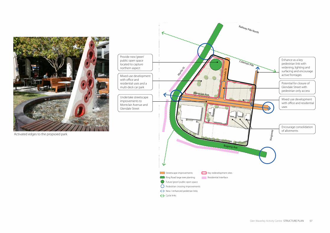
Glen Waverley Activity Centre STRUCTURE PLAN 57
Streetscape improvements
Ring Road large tree planting
Future ‘green’ public open space
Pedestrian crossing improvements
New / enhanced pedetrian links
Cycle links
Key redevelopment sites
Residential Interface
Activated edges to the propsoed park
Coleman Pde
Gle
ndal
e St
Myr
tle St
Montclair Ave
Bogong Ave
King
sway
Railway Pde North
Undertake streetscape improvements to Montclair Avenue and Glendale Street
Provide new ‘green’ public open space located to capture northern aspect
Mixed use development with office and residential uses and a multi-deck car park
Potential for closure of Glendale Street with pedestrian only access
Mixed use development with office and residential uses
Encourage consolidation of allotments
Enhance as a key pedestrian link with widening, lighting and surfacing and encourage active frontages
58 Glen Waverley Activity Centre STRUCTURE PLAN
P3. ff
PRECINCT 3: TRANSPORT INTERCHANGE AND EUNEVAThe transport interchange will be enhanced as a key destination in the GWAC. A long term plan for the precinct will see improved function and integration into the centre, and significant development opportunities.
ObjectiveTo create a highly active mixed use precinct which integrates an efficient and high amenity public transport interchange with retail, housing and office mixed use developments
Strategies• Provide short and long term plans for the transport
interchange that aim to improve its amenity and role within the activity centre
• Provide for mixed use retail / residential / office development East of Myrtle Street / Euneva Avenue and primarily residential development west
• Support the long term lowering of the rail line to achieve the ultimate Ring Road network and provide development opportunities above the transport interchange
• Enhance pedestrian connections between the Glen Waverley Secondary School and the Transport Interchange
• Improve signage to the train station and bus interchange
ActionsP3.1 Work with VicTrack to develop a master plan for a staged
redevelopment of the transport interchange precinct. The master plan should seek to:
• Provide for a lowered railway station and rail line to enable the implementation of the Ring Road
• Provide for an efficient bus interchange in its current, general location with good connections to the railway station and a high level of amenity and safety for pedestrians
• Provide retail / business services uses to Railway Parade North and Coleman Parade frontages east of the Ring Road
• Provide for residential and office uses on levels above the station / bus interchange
P3.2 In the shorter term implement measures to improve pedestrian safety around the bus interchange particularly at the eastern end of the bus interchange. Such measures could include raised threshold paving at the eastern end along wider and clearly defined pedestrian zebra crossings
P3.3 Investigate opportunities for providing dynamic signage across the GWAC that displays live information about train and bus departures
P3.4 Work with VicTrack to develop an integrated masterplan for the redevelopment of the at grade car park site bounded by O’Sullivan Road, Euneva Avenue and the railway line in the south. The masterplan should consider:
• Medium and higher density residential development that reduces in scale twoards the western residential interface
• An east west pedstrian connection through the site with activation and surveillance from adjoining land uses
• An efficient multi-deck / multi-level basement car park that provides commuter car parking needs
• A small pocket park public open space that captures the northern sunlight along O’sullivan Road. This park should provide a playground and the potential for community gardens or a productive landscape
P3.5 Provide for widening of Euneva Avenue between Railway Parade North and O’Sullivan Road. This should be widened to the west and undertaken in accordance with the staged Ring Road implementation
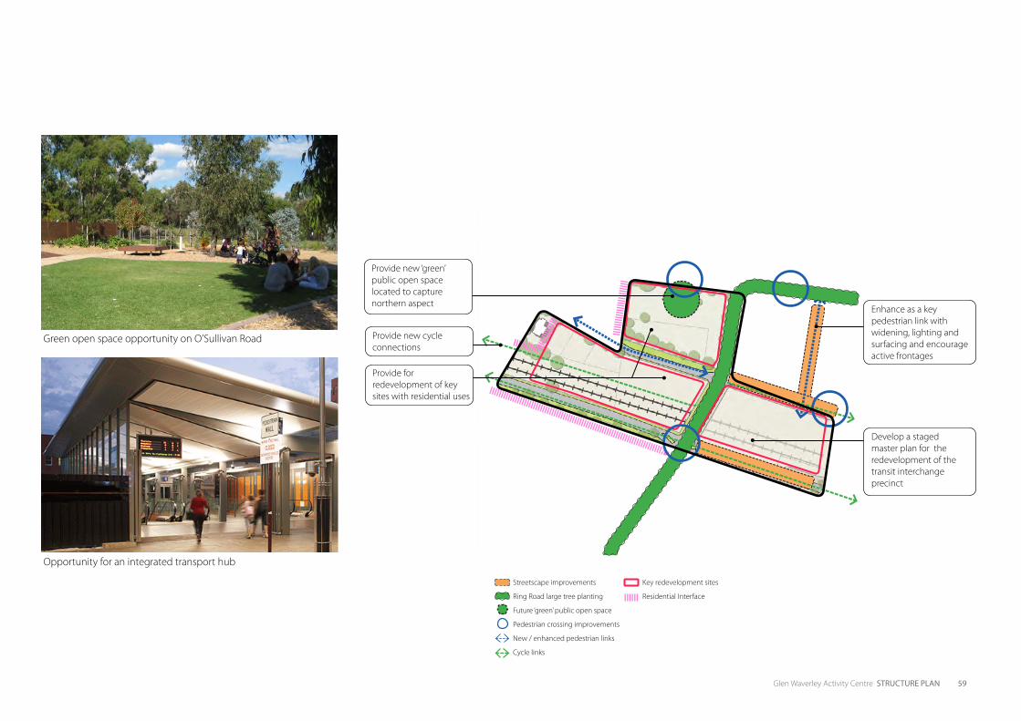
Glen Waverley Activity Centre STRUCTURE PLAN 59
Streetscape improvements
Ring Road large tree planting
Future ‘green’ public open space
Pedestrian crossing improvements
New / enhanced pedestrian links
Cycle links
Key redevelopment sites
Residential Interface
Opportunity for an integrated transport hub
Green open space opportunity on O’Sullivan Road
Provide new ‘green’ public open space located to capture northern aspect
Provide for redevelopment of key sites with residential uses
Provide new cycle connections
Develop a staged master plan for the redevelopment of the transit interchange precinct
Enhance as a key pedestrian link with widening, lighting and surfacing and encourage active frontages
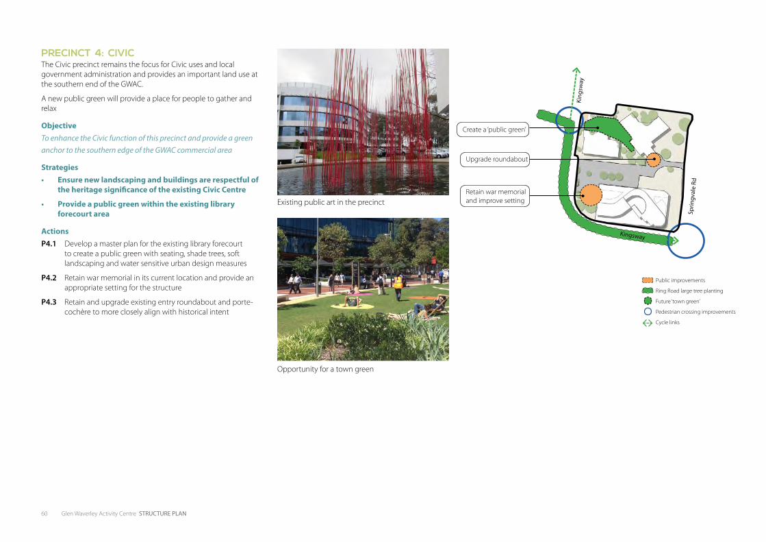
60 Glen Waverley Activity Centre STRUCTURE PLAN
P4. ff
PRECINCT 4: CIVICThe Civic precinct remains the focus for Civic uses and local government administration and provides an important land use at the southern end of the GWAC.
A new public green will provide a place for people to gather and relax
ObjectiveTo enhance the Civic function of this precinct and provide a green anchor to the southern edge of the GWAC commercial area
Strategies• Ensure new landscaping and buildings are respectful of
the heritage significance of the existing Civic Centre
• Provide a public green within the existing library forecourt area
ActionsP4.1 Develop a master plan for the existing library forecourt
to create a public green with seating, shade trees, soft landscaping and water sensitive urban design measures
P4.2 Retain war memorial in its current location and provide an appropriate setting for the structure
P4.3 Retain and upgrade existing entry roundabout and porte-cochère to more closely align with historical intent
Public improvements
Ring Road large tree planting
Future ‘town green’
Pedestrian crossing improvements
Cycle links
Opportunity for a town green
Existing public art in the precinct
Sprin
gval
e Rd
Kingsway
King
sway
Create a ‘public green’
Upgrade roundabout
Retain war memorial and improve setting
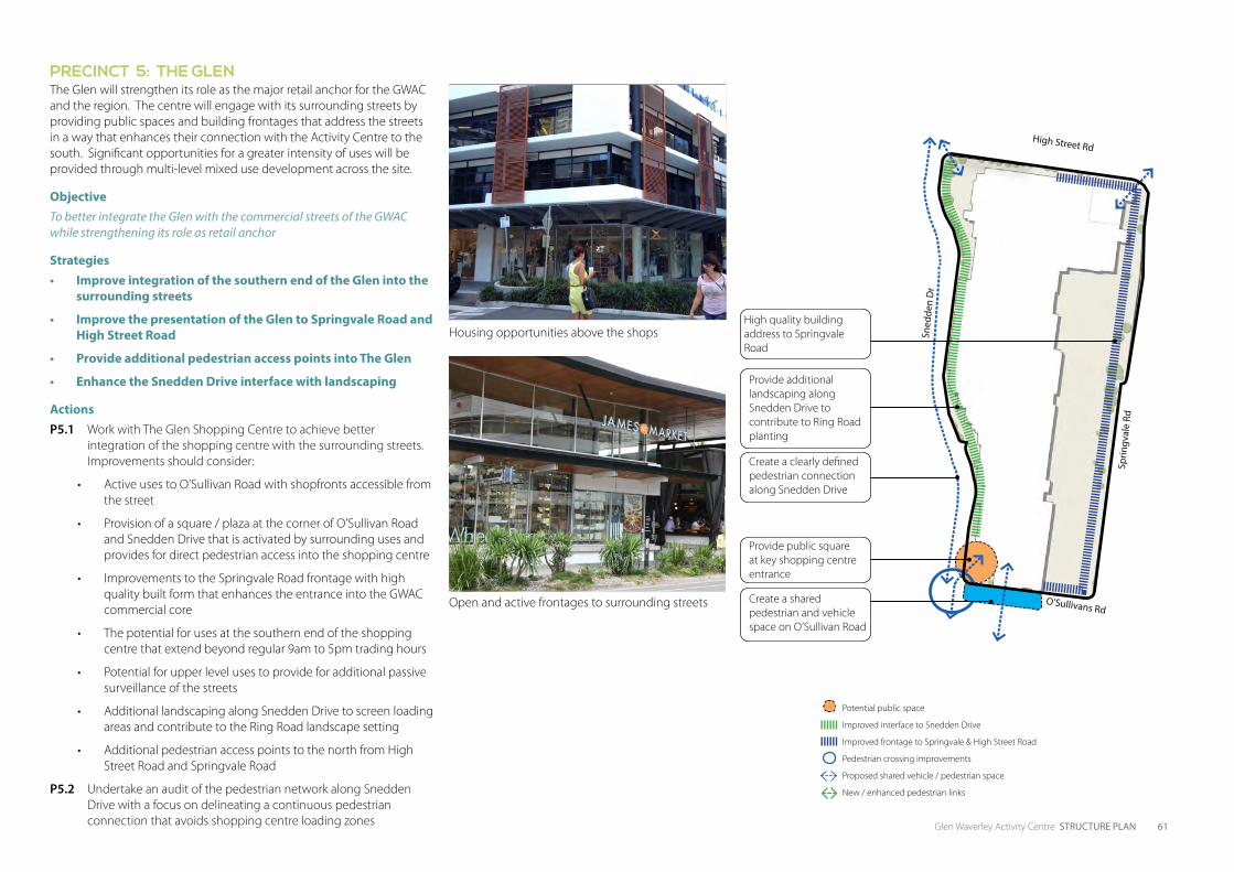
Glen Waverley Activity Centre STRUCTURE PLAN 61
P5. ffPRECINCT 5: THE GLEN The Glen will strengthen its role as the major retail anchor for the GWAC and the region. The centre will engage with its surrounding streets by providing public spaces and building frontages that address the streets in a way that enhances their connection with the Activity Centre to the south. Significant opportunities for a greater intensity of uses will be provided through multi-level mixed use development across the site.
ObjectiveTo better integrate the Glen with the commercial streets of the GWAC while strengthening its role as retail anchor
Strategies• Improve integration of the southern end of the Glen into the
surrounding streets
• Improve the presentation of the Glen to Springvale Road and High Street Road
• Provide additional pedestrian access points into The Glen
• Enhance the Snedden Drive interface with landscaping
ActionsP5.1 Work with The Glen Shopping Centre to achieve better
integration of the shopping centre with the surrounding streets. Improvements should consider:
• Active uses to O’Sullivan Road with shopfronts accessible from the street
• Provision of a square / plaza at the corner of O’Sullivan Road and Snedden Drive that is activated by surrounding uses and provides for direct pedestrian access into the shopping centre
• Improvements to the Springvale Road frontage with high quality built form that enhances the entrance into the GWAC commercial core
• The potential for uses at the southern end of the shopping centre that extend beyond regular 9am to 5pm trading hours
• Potential for upper level uses to provide for additional passive surveillance of the streets
• Additional landscaping along Snedden Drive to screen loading areas and contribute to the Ring Road landscape setting
• Additional pedestrian access points to the north from High Street Road and Springvale Road
P5.2 Undertake an audit of the pedestrian network along Snedden Drive with a focus on delineating a continuous pedestrian connection that avoids shopping centre loading zones
Open and active frontages to surrounding streets
Housing opportunities above the shops
Sprin
gval
e Rd
Sned
den
Dr
High Street Rd
O’Sullivans Rd
Potential public space
Improved interface to Snedden Drive
Improved frontage to Springvale & High Street Road
Pedestrian crossing improvements
Proposed shared vehicle / pedestrian space
New / enhanced pedestrian links
Provide additional landscaping along Snedden Drive to contribute to Ring Road planting
High quality building address to Springvale Road
Create a clearly defined pedestrian connection along Snedden Drive
Create a shared pedestrian and vehicle space on O’Sullivan Road
Provide public square at key shopping centre entrance
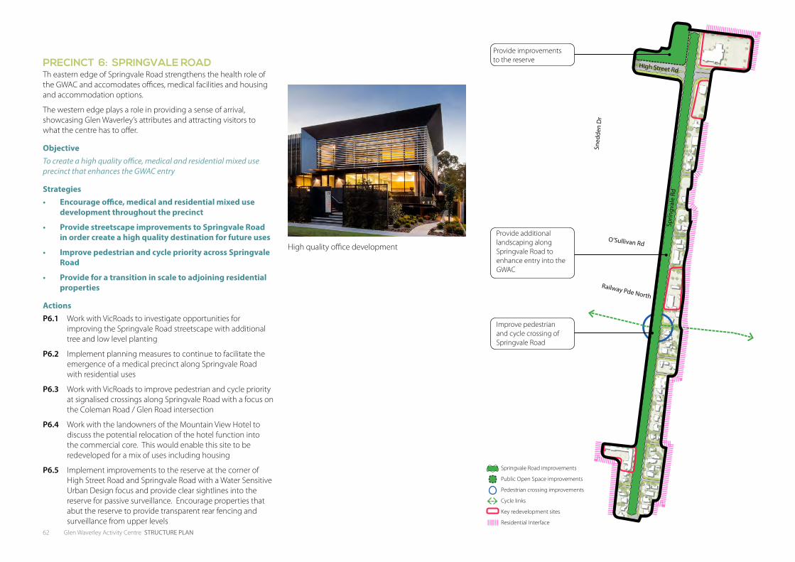
62 Glen Waverley Activity Centre STRUCTURE PLAN
P6. ff
PRECINCT 6: SPRINGVALE ROADTh eastern edge of Springvale Road strengthens the health role of the GWAC and accomodates offices, medical facilities and housing and accommodation options.
The western edge plays a role in providing a sense of arrival, showcasing Glen Waverley’s attributes and attracting visitors to what the centre has to offer.
ObjectiveTo create a high quality office, medical and residential mixed use precinct that enhances the GWAC entry
Strategies• Encourage office, medical and residential mixed use
development throughout the precinct
• Provide streetscape improvements to Springvale Road in order create a high quality destination for future uses
• Improve pedestrian and cycle priority across Springvale Road
• Provide for a transition in scale to adjoining residential properties
ActionsP6.1 Work with VicRoads to investigate opportunities for
improving the Springvale Road streetscape with additional tree and low level planting
P6.2 Implement planning measures to continue to facilitate the emergence of a medical precinct along Springvale Road with residential uses
P6.3 Work with VicRoads to improve pedestrian and cycle priority at signalised crossings along Springvale Road with a focus on the Coleman Road / Glen Road intersection
P6.4 Work with the landowners of the Mountain View Hotel to discuss the potential relocation of the hotel function into the commercial core. This would enable this site to be redeveloped for a mix of uses including housing
P6.5 Implement improvements to the reserve at the corner of High Street Road and Springvale Road with a Water Sensitive Urban Design focus and provide clear sightlines into the reserve for passive surveillance. Encourage properties that abut the reserve to provide transparent rear fencing and surveillance from upper levels
Springvale Road improvements
Public Open Space improvements
Pedestrian crossing improvements
Cycle links
Key redevelopment sites
Residential Interface
High quality office development
Sprin
gval
e Rd
Sned
den
Dr
High Street Rd
O’Sullivan Rd
Railway Pde North
Provide additional landscaping along Springvale Road to enhance entry into the GWAC
Provide improvements to the reserve
Improve pedestrian and cycle crossing of Springvale Road
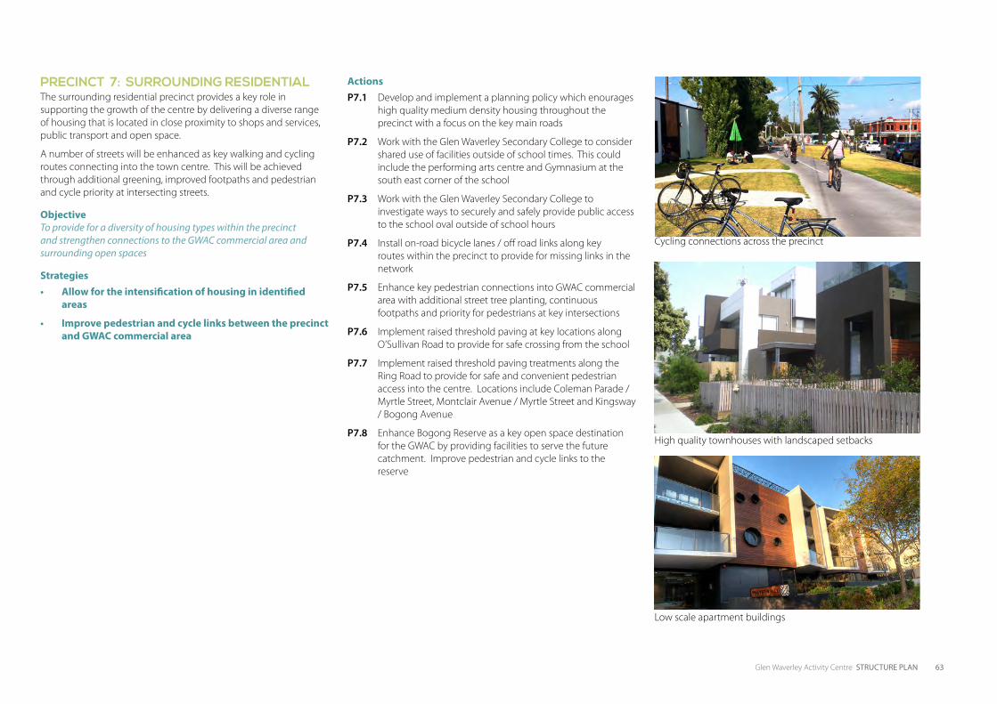
Glen Waverley Activity Centre STRUCTURE PLAN 63
P7. ff
PRECINCT 7: SURROUNDING RESIDENTIALThe surrounding residential precinct provides a key role in supporting the growth of the centre by delivering a diverse range of housing that is located in close proximity to shops and services, public transport and open space.
A number of streets will be enhanced as key walking and cycling routes connecting into the town centre. This will be achieved through additional greening, improved footpaths and pedestrian and cycle priority at intersecting streets.
Objective To provide for a diversity of housing types within the precinct and strengthen connections to the GWAC commercial area and surrounding open spaces
Strategies• Allow for the intensification of housing in identified
areas
• Improve pedestrian and cycle links between the precinct and GWAC commercial area
ActionsP7.1 Develop and implement a planning policy which enourages
high quality medium density housing throughout the precinct with a focus on the key main roads
P7.2 Work with the Glen Waverley Secondary College to consider shared use of facilities outside of school times. This could include the performing arts centre and Gymnasium at the south east corner of the school
P7.3 Work with the Glen Waverley Secondary College to investigate ways to securely and safely provide public access to the school oval outside of school hours
P7.4 Install on-road bicycle lanes / off road links along key routes within the precinct to provide for missing links in the network
P7.5 Enhance key pedestrian connections into GWAC commercial area with additional street tree planting, continuous footpaths and priority for pedestrians at key intersections
P7.6 Implement raised threshold paving at key locations along O’Sullivan Road to provide for safe crossing from the school
P7.7 Implement raised threshold paving treatments along the Ring Road to provide for safe and convenient pedestrian access into the centre. Locations include Coleman Parade / Myrtle Street, Montclair Avenue / Myrtle Street and Kingsway / Bogong Avenue
P7.8 Enhance Bogong Reserve as a key open space destination for the GWAC by providing facilities to serve the future catchment. Improve pedestrian and cycle links to the reserve
Cycling connections across the precinct
High quality townhouses with landscaped setbacks
Low scale apartment buildings
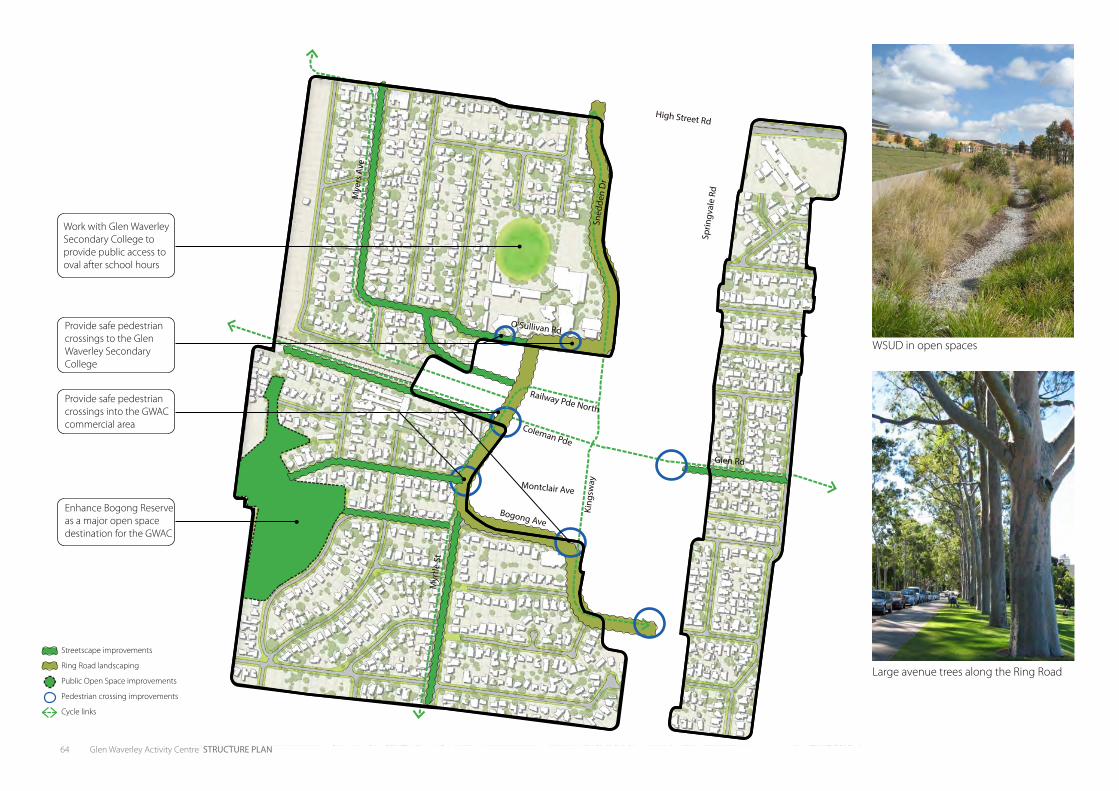
64 Glen Waverley Activity Centre STRUCTURE PLAN
Streetscape improvements
Ring Road landscaping
Public Open Space improvements
Pedestrian crossing improvements
Cycle links
WSUD in open spaces
Large avenue trees along the Ring Road
High Street Rd
Glen Rd
Coleman Pde
Railway Pde North
O’Sullivan Rd
Montclair Ave
Bogong Ave
Sprin
gval
e Rd
King
sway
Sned
den
Dr
Mye
rs A
ve
Myr
tle S
t
Enhance Bogong Reserve as a major open space destination for the GWAC
Provide safe pedestrian crossings into the GWAC commercial area
Provide safe pedestrian crossings to the Glen Waverley Secondary College
Work with Glen Waverley Secondary College to provide public access to oval after school hours

WSUD in open spaces
Large avenue trees along the Ring Road
6IMPLEMENTATION
66 Glen Waverley Activity Centre STRUCTURE PLAN
6.2 MONITORING AND REVIEWAs part of the implementation process, Monash City Council will provide a progress report on the implementation of the Structure Plan. The Structure Plan review process will occur every five years. This will identify and analyse:
• The actions and projects that have been undertaken or underway
• The success of key actions or projects
• Consistency of all projects with the shared vision for the GWAC
• Any blockages preventing successful implementation.
This process will allow Council to measure the success of the program and allocated future resources as necessary and allow for the implementation program to be adjusted to ensure the vision is being achieved.
6.1 NEXT STEPSIMPLEMENTATION PLANA detailed implementation plan will be developed following the finalisation of the Structure Plan. The implementation plan will outline the steps required to implement each of the actions in this document including implementation responsibilities, priorities and timing. This will ensure that the aspirations of the shared vision will be realised through projects on the ground.
This will include:
• Infrastructure upgrades
• Public realm improvements
• Implementation of the Glen Waverley Sustainable Transport Plan
• Advocacy with State Government Agencies
• Marketing plan
• Development facilitation
COUNCIL ADOPTIONThe Structure Plan and Implementation Plan will be issued to Council for formal adoption.
PLANNING SCHEME AMENDMENTOnce the Structure Plan is adopted by Council, a planning scheme amendment will be prepared to implement aspects of the Structure Plan into the Glen Waverley Planning Scheme. This will undergo an additional phase of consultation.
6. IMPLEMENTATION