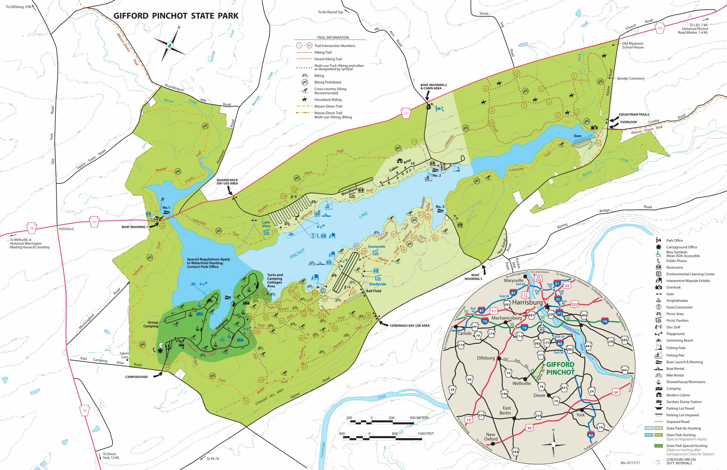
gifford pinchot state park to ski round top - … · gifford pinchot state park no.1 lake view...

1
16 17 15 45 24 44 31 33 32 21 20 19 22 23 25 26 18 27 28 34 29 35 36 38 37 40 41 39 42 13 12 14 11 10 9 8 6 7 5 4 2 1 43 3 177 177 177 177 177 177 177 177 177 74 177 177 177 74 74 177 177 177 74 74 450 450 450 350 350 350 350 350 350 350 400 400 400 400 500 550 600 450 450 450 450 450 500 500 500 500 550 550 550 550 550 400 450 500 500 600 600 650 550 550 550 500 500 500 550 550 600 600 650 500 500 500 500 500 500 500 500 500 500 550 550 550 600 600 600 650 700 600 600 600 650 550 550 500 500 500 550 500 500 500 500 550 550 Creek Beaver Creek Rock PINCHOT Ramsey Creek Beaver Creek Creek Fortney Creek Conewago LAKE Lake Depth 32ft Trail Lakeside Trail Trail Ridge Trail Lakeside Farm Old Trail Gravel Oak Trail Trail Pinchot Tr. Pinchot Trail Trail Pinchot Tr. Trail Alpine Trail Fern Trail Point Tr. Boulder Trail Trail Lakeside Trail Race Quaker Trail Lakeside Trail Creek Beaver Mason-Dixon Trail Ridge Trail Lakeside Trail L a k e s i d e L a k e s i d e M id l a n d M ason - Dixon Tra il L a k e s i d e To Dillsburg, 9 Mi. To Wellsville, & Historical Warrington Meeting House & Cemetery To PA 74 To Dover, York, 12 Mi. To I-83, 7 Mi. Historical Pinchot Road Marker, 1.4 Mi. Rev. 07/17/17 To Ski Round Top ROSSVILLE STRAIGHT HILL AREA GIFFORD PINCHOT STATE PARK No.1 Lake View Group Camping Special Regulations Apply to Waterfowl Hunting. Contact Park Office Camping Ball Field Woodland 1 2 3 4 5 6 7 8 9 10 Area Cabin No. 3 No. 2 Dam BOAT MOORING 3 CAMPGROUND QUAKER RACE DAY USE AREA BOAT MOORING 2 & CABIN AREA EQUESTRIAN TRAILS OVERLOOK Yurts and Camping Cottages Area BOAT MOORING 1 CONEWAGO DAY USE AREA Sunnyside Shadyside Road Road Road Mill Thundergust Pinetown York Old Squire G r atz Road Area Road Mockingbird East Camping Road Road Alpine Road Airy Road Jug Stone Mt. Road Mill Kunkle Road N e w B e t h e l Road Church Alpine Road Road Conley Road Bridge Boring Bender Cemetery Old Maytown School House Salem Cem. To Al l ento w n To Hazl eton To G ett ysburg T o G ett ysb urg T o Ep hrata T o Readin g To Lewi sto w n To Sel i nsgrove T o Pi ttsb urg h T o C h a m b e rs b u r g T o P hila d elp h ia T o La n c a s t e r T o Baltimore 83 83 283 283 81 81 76 15 11 30 22 322 30 382 177 76 76 81 81 83 83 83 83 177 11 15 22 322 382 81 81 581 581 283 283 230 441 441 24 921 74 74 74 234 194 194 114 174 174 94 34 234 74 230 641 74 GIFFORD PINCHOT Wellsville Dover Harrisburg York Carlisle East Berlin New Marysville Mechanicsburg Dillsburg Exit 35 Exit Exit 32 RIVER SUSQUEHANNA 39A Oxford Exit 59 Exit 67 Exit 70 Exit 50 Exit 46 Exit 247 Exit 242 Exit 236 Exit 226 Exit 52 Exit 65 Old York Rd. Alpine Rd. N 800 800 1600 FEET 0 200 200 400 METERS 0 N 400 350 1 45 CONTOURS ARE ON 50 FT. INTERVALS Park Office Campground Office Blue Symbols Mean ADA Accessible Public Phone Restrooms Environmental Learning Center Interpretive Wayside Exhibit Overlook Gate Amphitheater Food Concession Picnic Area Picnic Pavilion Disc Golf Playground Swimming Beach Fishing Pads Fishing Pier Boat Launch & Mooring Boat Rental Bike Rental Showerhouse/Restrooms Camping Modern Cabins Sanitary Dump Station Parking Lot Paved Parking Lot Unpaved Unpaved Road State Park No Hunting State Park Hunting (Special Regulations Apply) State Park Special Hunting (Open to Hunting after Campground Closes for Season) Trail Intersection Numbers Hiking Trail Paved Hiking Trail Multi-use Trail: Hiking and other as designated by symbol Biking Biking Prohibited Cross-country Skiing Recommended Horseback Riding Mason-Dixon Trail Mason-Dixon Trail Multi-use: Hiking, Biking TRAIL INFORMATION

Upload: phungnga

Post on 02-Jul-2018

214 views

Category:

Documents


0 download

TRANSCRIPT

16

17

15

4524

44

31

33

32

21

20

1922

23 2526 1827

2834

29

35

36 38

37

4041

39 42

13

12

14

11

10

9

8

6

7

5

4

2

1

43

3

177177177

177177

177

177

177

177

74

177

177

177

74

74

177

177

177

74

74 450

450

450

350

350

350

350

350

350

350

400

400

400

400

500

550

600

450

450

450

450

450

500

500

500

500

550

550

550

550

550

400

450500

500

600

600

650

550

550

550

500

500

500

550

550

600

600

650

500

500

500

500

500

500

500

500

500

500

550

550

550

600

600

600

650

700

600

600

600

650

550

550

500

500

500

550

500

500

500

500

550

550

Creek

Beaver

Creek

Rock

PINCHOTRam

sey

Cree

k

Beaver Creek

Creek

Fort

ney

Creek

Cone

wag

o

LAKE

Lake Depth 32ft

Trail

Lakeside

Trail

Trail

Ridge

Trail

Lakeside

Farm

Old

Trail

Gravel

Oak

Trail

Trail

Pinc

hot

Tr.

Pinchot

Trail

Trail

Pinchot

Tr.

Trai

l

Alpine

Trail

Fern

Trail

Poin

tTr

.Boul

der

Trail

Trail

Lakeside

Trail

Race

Quaker

Trai

l

Lakeside

Trail

Creek

Beaver

Mason-Dixon

Trail

Ridge

Trail

LakesideTrail

Lake

side

Lakeside

Mid

land

Mason - Dixon Trail

Lake s id e

To Dillsburg, 9 Mi.

To Wellsville, &Historical WarringtonMeeting House & Cemetery

To PA 74To Dover,York, 12 Mi.

To I-83, 7 Mi.Historical Pinchot

Road Marker, 1.4 Mi.

Rev. 07/17/17

To Ski Round Top

ROSSVILLE

STRAIGHT HILL A

REA

GIFFORD PINCHOT STATE PARK

No.1

Lake View

GroupCamping

Special Regulations Applyto Waterfowl Hunting.Contact Park O�ce

Camping

Ball Field

Woodland

12345

67

89

10Area

Cabin

No. 3

No. 2

Dam

BOAT MOORING 3

CAMPGROUND

QUAKER RACEDAY USE AREA

BOAT MOORING 2& CABIN AREA

EQUESTRIAN TRAILS

OVERLOOK

Yurts andCampingCottagesArea

BOAT MOORING 1

CONEWAGO DAY USE AREA

Sunnyside

Shadyside

Road

Road

RoadMill

Thundergust

Pine

tow

n

York

Old

Squire G

ratz Road

Area

Road

Mock

ingbird

East CampingRoad

Road

Alpine

Road

Airy

Road

Jug

Stone

Mt.

Road

Mill

Kunkle

Road

New B

ethe

l

Road

Church

Alp

ine

R

oad

Road

Conley

RoadBridge

Boring

Bender Cemetery

Old MaytownSchool House

SalemCem.

To Allentown

To Hazleton

To Gettysburg

To Gettysburg

To Ephrata

To Reading

To Lewistown

To Selinsgrove

To P

ittsb

urgh

T

o C

ham

ber

sbur

g

To Philadelphia

To L

anca

ster

To Baltimore

8383

283283

8181

76

15

11

30

22

322

30

382

177

76

76

8181

8383

8383

177

1115

22322

382

8181

581

581 283

283230441

441

2492174

74

74

234

194

194

114174

174

94

34

234

74

230

641

74

GIFFORDPINCHOT

Wellsville

Dover

Harrisburg

York

Carlisle

EastBerlin

New

Marysville

Mechanicsburg

Dillsburg

Exit 35

Exit

Exit 32

RIVER

SUSQUEHANNA39A

Oxford

Exit 59

Exit67

Exit70

Exit50

Exit46

Exit247

Exit242

Exit236

Exit226

Exit 52

Exit 65

Old YorkRd.

Alpin

eRd

.

N800 800 1600 FEET0

200 200 400 METERS0

N

400350

1 45

CONTOURS ARE ON50 FT. INTERVALS

Park Office

Campground OfficeBlue SymbolsMean ADA AccessiblePublic Phone

Restrooms

Environmental Learning Center

Interpretive Wayside Exhibit

Overlook

Gate

Amphitheater

Food Concession

Picnic Area

Picnic Pavilion

Disc Golf

Playground

Swimming Beach

Fishing Pads

Fishing Pier

Boat Launch & Mooring

Boat Rental

Bike Rental

Showerhouse/Restrooms

Camping

Modern Cabins

Sanitary Dump Station

Parking Lot Paved

Parking Lot Unpaved

Unpaved Road

State Park No Hunting

State Park Hunting(Special Regulations Apply)

State Park Special Hunting(Open to Hunting afterCampground Closes for Season)

Trail Intersection Numbers

Hiking Trail

Paved Hiking Trail

Multi-use Trail: Hiking and otheras designated by symbol

Biking

Biking Prohibited

Cross-country SkiingRecommended

Horseback Riding

Mason-Dixon Trail

Mason-Dixon TrailMulti-use: Hiking, Biking

TRAIL INFORMATION