george otis smith, director - pubs.usgs.gov · pdf filegeorge otis smith, director school 97...
TRANSCRIPT
JAMESTOWN-TOWER FOLIO NO. 168
DEPARTMENT OF THE INTERIOR
UNITED STATES GEOLOGICAL SURVEY
GEORGE OTIS SMITH, DIRECTOR
SCHOOL 97 MINES AND METALLURGY^ STATS.
\
I
JAMESTOWN-TOWER FOLIOJAMESTOWN, ECKELSOST, AND TOWER QUADRANGLES ,
NORTH DAKOTA
DANIEL E. WLLARD
ANDSTATE GQLLKGf,
JAMESTOWN-TOWER FOLIO NO. 168
WASHINGTON, D. C.
ENGRAVED AND PRINTED BY THE U. S. GEOLOGICAL SURVEY
GEORGE W.STOSE, EDITOR OF GEOLOGIC MAPS S.J.KUBEL, CHIEF ENGRAVER
1909
/ ^L^n^^^l
GEOLOGIC ATLAS OF THE UNITED STATES.
The Geological Survey is making a geologic atlas of the United States, which is being issued in parts, called folios. Each folio includes topographic and geologic maps of a certain area, together with descriptive text.
THE TOPOGRAPHIC MAP.\ fThe features represented on the topographic map are of
three distinct kinds (1) inequalities of surface, called relief, as plains, plateaus, valleys, hills, and mountains; (2) distribu tion of water, called drainage, as streams, lakes, and swamps; (3) the works of man, called culture, as roads, railroads, boundaries, villages, and cities.
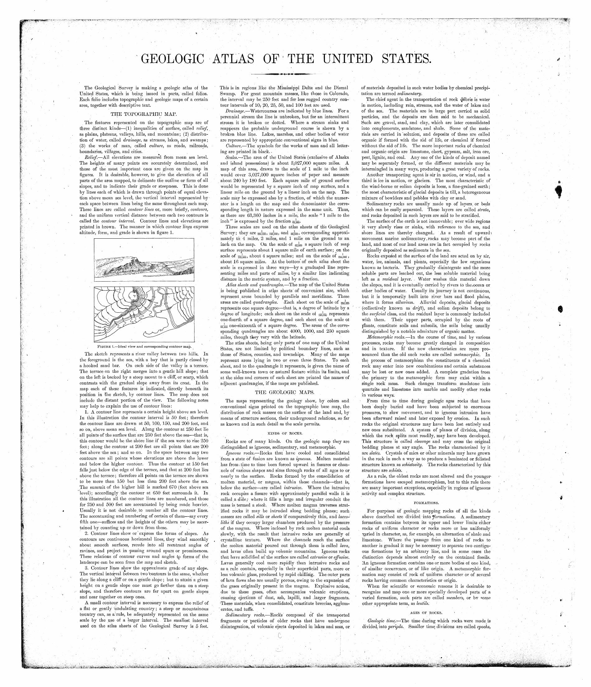
Relief. All elevations are measured from mean sea level. The heights of many points are accurately determined, and those of the most important ones are given on the map in figures. It is desirable, however, to'give the elevation of all parts of the area mapped, to delineate the outline or form of all slopes, and to indicate their grade or steepness. This is done by lines each of which is drawn through points of equal eleva tion above mean sea level, the vertical interval represented by each space between lines being the same throughout each map. These lines are called contour lines or, more briefly, contours, and the uniform vertical distance between each two contours is called the contour interval. Contour lines and elevations are printed in brown. The manner in which contour lines express altitude, form, and grade is shown in figure 1.
FIGURE 1. Ideal view and corresponding contour map.
The sketch represents a river valley between two hills. Inthe foreground is the sea, with a bay that is partly closed by a hooked sand bar. On each side of the valley is a terrace. The terrace on the right merges into a gentle hill slope; that on the left is backed by a steep ascent to a cliff, or scarp, which contrasts with the gradual slope away from its crest. In the map each of these features is indicated, directly beneath its position in the Sketch, by contour lines. The map does not include the distant portion of the view. The following notes may help to explain the use of contour lines:
1. A contour line represents a certain height above sea level. In this illustration the contour interval is 50 feet; therefore the contour lines are drawn at 50, 100, 150, and 200 feet, and so on, above mean sea level. Along the contour at 250 feet lie all points of the surface that are 250 feet above the sea that is, this contour would be the shore line if the sea were to rise 250 feet; along the contour at 200 feet are all points that are 200 feet above vthe sea ; and so on. In the space between any two contours are all points whose elevations are above the lower and below the higher contour. Thus the contour at 150 feet falls just below the edge of the terrace, and that at 200 feet lies above the terrace; therefore all points on the terrace are shown to be more than 150 but less than 200 feet above the sea. The summit of the higher hill is marked 670 (feet above sea level); accordingly the contour at 650 feet surrounds it. In this illustration all the contour lines are numbered, and those for 250 and 500 feet are accentuated by being made heavier. Usually it is not desirable.to number all the contour lines. The accentuating and numbering of certain of them- say every fifth one- suffices and the 'heights of the others may be ascer tained by counting up or down from these. '
2. Contour lines show or' express the forms of slopes. As contours are continuous horizontal lines, they wind smoothly about smooth surfaces, recede into all reentrant angles of ravines, and project in -passing around spurs or prominences. These relations of contour curves and angles tp forms of the landscape can be seen from the map and sketch.
3. Contour lines show the approximate grade of any slope. The vertical interval between two bentours is the same, whether they lie along a cliff1 or on a gentle slope; but to attain a given height on a gentle slope one must go farther than on a steep slope, and therefore contours are far apart on gentle slopes and near together on steep ones.
A small contour interval is necessary to express the relief of a flat or gently undulating country; a steep or mountainous 'country can, as a i rule, be adequately represented on the same scale by the use of a larger interval. The smallest interval used on the atlas sheets of the Geological Survey is 5 feet.
This is in regions like the Mississippi Delta and the Dismal Swamp. For great mountain masses, like those in Colorado, the interval may be 250 feet and for less rugged country con tour intervals of 10,- J20, 25, 50, and 100 feet are used.
Drainage. Watercourses are indicated by blue lines. For a perennial stream the line is unbroken, but for an intermittent stream it is broken or dotted. Where a stream sinks and reappears the probable underground course is shown by a broken blue line. Lakes, marshes, and other bodies of water are represented by appropriate conventional signs in blue.
Culture. The symbols for the works of man and all letter ing are printed in black. ,
Scales.^ The area of the United States (exclusive of Alaska and island possessions) is about 3,027,000 square miles. A map of this area, drawn to the scale of 1 mile to the inch would cover 3,027,000 square inches of paper and measure about 240 by 180 feet. Each square mile of ground surface would be represented by a square inch of map surface, and a linear mile on the ground by a linear inch on the map. The scale may be expressed also by a fraction, of which the numer ator is a length on the map and the denominator the corre sponding length in nature expressed in the same unit. Thus, as there are 63,360 inches in a mile, the scale " 1 mile to the inch " is expressed- by the fraction
Three scales are used on the atlas sheets of the Geological Survey; they are ^^m, ^m, and ggjoo, corresponding approxi mately to 4 miles, 2- miles, and 1 mile on the ground to' an inch on the map. On the scale of esjoo a square inch of mapsurface represents about 1 square mile of earth surface ; on the scale of i25;ooo, about 4 square miles; and on the scale of ^^ , about 16 square miles. At the bottom of each atlas sheet the scale is expressed in three ways by a graduated line repre senting miles and parts of miles, by a similar line indicating distance in the metric system, and by a fraction.
Atlas sheets and quadrangles. The map of the United States is being published in atlas sheets of convenient size, which represent areas bounded by parallels and meridians. These areas are called quadrangles. .Each sheet on the scale ofrepresents one square degree- that is, a degree of latitude by a degree of longitude; each sheet on the scale of jgpoo representsone-fourth of a square degree, and each sheet on the scale ol
one-sixteenth of a square degree. The areas of the corresponding quadrangles are about 4000, 1000, and 250 square miles, though they vary with the latitude.
The atlas sheets, being only parts of one map of the United States, are not limited by political boundary lines, such as those of States, counties, and townships. Many of the maps represent areas lying in two or even three States. To each sheet, and to the quadrangle it represents, is given the name of some well-known town or natural feature within its limits, and at the sides and corners of each sheet are printed the names of adjacent quadrangles, if the maps are published.
THE GEOLOGIC MAPS.
The maps representing the geology show, by colors and conventional signs printed on the topographic base map, the distribution of rock masses on the surface of the land and, by means of structure sections, their underground relations, so far as known and in such detail as the scale permits.
KINDS OF ROCKS.
Rocks are of many kinds. On the geologic map they are distinguished as igneous, sedimentary, and metamorphic.
Igneous rocks. Rocks that have cooled and consolidated from a state of fusion are known as igneous. Molten material has from \time to time been forced upward in fissures or chan nels of various shapes and sizes through rocks of all ages to or nearly to the surface. Rocks formed by the consolidation of molten material, or magma, within these channels that is, below the surface rare called intrusive. Where the intrusive rock occupies a fissure with approximately parallel walls it is called a dike; where it fills a large and irregular conduit the mass is termed a stock. Where molten magma traverses strat ified rocks it may be intruded along bedding planes; such masses are called sills or sheets if comparatively thin, and lacco liths if they occupy larger chambers produced by the pressure of the magma. Where inclosed by rock molten material cools slowly, with the result that intrusive rocks are generally of crystalline texture. Where the channels reach the surface the molten material' poured out through them is called lava, and lavas often build up volcanic mountains. Igneous rocks that have solidified at^the surface are called extrusive or effusive. Lavas generally cool more rapidly than intrusive rocks and as a rule contain, especially in their superficial parts, more or less volcanic glass, produced by rapid chillirig. The outer parts of lava flows also are usually porous, owing to the expansipn of the gases originally present in the magma. Explosive action, due to these gases, often accompanies volcanic eruptions, causing ejections of dust, ash, lapilli, and .larger fragments. These materials, when consolidated, constitute breccias, agglom erates, and tuff's. x ^
Sedimentary rocks. Rocks composed of the transported fragments or "particles of older rocks that have undergone disintegration, of volcanic ejecta deposited in lakes and seas, or
of materials deposited in such water bodies by chemical precipi tation are termed sedimentary.
The chief agent in the transportation of rock <J^bris *s water in motion, including rain, streams, and the water of lakes and of the sea. The materials are in large part carried as solid particles, and the deposits are then said to be mechanical. Such are gravel, sand, and clay, which are later consolidated into conglomerate, sandstone, and shale. Some of the mate rials are carried in "solution, and deposits of these are called organic if formed with the aid of life, or chemical if formed without the aid of life. The more important rocks of chemical and organic origin are limestone, chert, gypsum, salt, iron ore, peat, lignite, and coal. Any one of the kinds of deposit named may be separately formed, or the different materials may be intermingled in many ways, producing a great variety of rocks.
Another transporting agent is air in motion, or wind, and a third is ice in motion, or glaciers. The most characteristic of the wind-borne or eolian deposits is loess, a fine-grained earth; the most characteristic of glacial deposits is till, a heterogeneous mixture of bowlders and pebbles with clay or sand.
Sedimentary rocks are usually made up of layers, or beds which can be easily separated. These layers are called strata, and rocks deposited in such layers are said to be stratified.
The surface of t'he earth is not immovable; over wide regions it very slowly rises or sinks,. with reference to the sea, and shore lines are thereby changed.- As a result of upward \ movement marine sedimentary t rocks may become part of the land, and most of our land areas are in fact occupied by rocks originally deposited as sediments in the sea.
Rocks exposed at the surface of the land are acted on by air, water, ice, animals, and plants, especially the low organisms known as bacteria. They gradually disintegrate and the more soluble parts are leached out, the less soluble material being left as a residual layer. . Water washes this material down the slopes, and it is eventually carried by rivers to the%ocean or other bodies of water. Usually its journey is not continuous, but it is temporarily .built into river bars and flood plains, where it forms alluvium. Alluvial deposits, glacial deposits (collectively known as driff), and eolian deposits belong to the surficial class, and the residual layer is commonly included with them. Their upper parts, occupied by the roots of plants, constitute soils and subsoils, the soils being usually distinguished by a notable admixture of organic matter.
Metamorphic rocks. In the course of time, and by various processes, rocks may become greatly changed in composition and in texture. If the new characteristics are more pro nounced than the old such rocks are called metamorphic. In the process of metamorphism the constituents of a chemical rock may enter into new combinations and certain substances may be lost or new ones added. A complete gradation from the primary to the metamorphic form may exist within a single rock mass. Such changes transform sandstone into quartzite and limestone into marble and modify other rocks in various ways;
1 From time to time during geologic ages rocks that have been deeply buried and have been subjected to enormous pressures, to slow movement, and to igneous intrusion have, been afterward raised and later exposed by erosion. In such rocks the original structures may have been lost entirely and new ones substituted. A system of planes of division, along which the rock splits most readily, may have been developed. This structure is called cleavage and may cross the original bedding planes at any angle. The rocks characterized by it are slates.. Crystals of mica or other minerals may have grown in the rock in such a way as to produce a laminated or foliated structure known as schistosity. The rocks characterized by this structure are schists. ^
As a rule, the oldest rocks are most altered and the younger formations have escaped metamorphism, but to this rule there are many important exceptions, especially in regions of igneous activity and complex structure.
FORMATIONS.
For purposes of geologic mapping rocks of all the kinds above described are divided into "formations. A sedimentary formation contains between its upper and lower limits either rocks of uniform character or rocks more or less uniformly ^aried in character, as, for example, an alternation of shale and limestone. Where the passage from one kind of rocks to another is gradual it may be necessary to separate two contigu ous formations by an arbitrary line, and in some cases the distinction depends almost entirely on the contained fossils. An igneous formation contains one or more bodies of one kind, of similar occurrence, or of like origin. A metamorphic for mation may consist of rock > of uniform character or of several rocks having common characteristics or origin.
When for scientific or economic reasons it is desirable to recognize and map one or more specially developed parts of a varied formation, such parts are called members, or bv <*ome other appropriate term, as lentils.
AGES OF ROCKS.
Geologic time,.- The time during which rocks were made is divided, into periods. Smaller time divisions are called epochs,
and still smaller ones stages. The age of a rock is expressed by the name of the time interval in which it was formed.
The sedimentary formations deposited during a period are grouped together into a system. The principal divisions of a system are called series. Any aggregate of formations less than a series is called a group.
Inasmuch as sedimentary deposits accumulate successively the younger rest on those that are older, and their relative ages may be determined by observing their positions. In many regions of intense disturbance, however, the beds have been overturned by folding or superposed by faulting, so that it may be difficult to determine their relative, ages from their present positions; under such conditions^ fossils, if present, may indicate which of two or more formations is .the oldest.
Many stratified rocks contain fossils, the remains or imprints of plants and animals which, at the time the strata were deposited, lived in bodies of water or were washed into them, or were buried in surficial deposits on the lancl. Such rocks! are called .fossiliferous. By studying fossils it has been found that the life of each period of the earth's history was to a great extent different from that of other periods. Only the simpler kinds of marine life existed when the oldest fossiliferous rocks were deposited. From time to time more complex kinds developed, apd as the simpler ones lived on in modified forms life became more varied. But during each period, there lived peculiar forms, which did not exist in earlier times and have not existed since; these are characteristic types, and they define the age of any bed of rock in which they are found. Other types passed on from period to period, and thus linked the systems together, forming a chain of life from the time of the oldest fossiliferous rocks to the present. Where two sedimentary formations are remote from each other and it is/impossible to observe their relative positions, the character istic fossil types found in them may determine which was deposited first. Fossil remains in the strata of different areas, provinces, and continents afford the most important means for combining local histories into a general earth history.
It is many places difficult or impossible to determine the age of an igneous formation, but the relative age^of such a forma tion can in general be ascertained by observing whether an associated sedimentary formation of known age is cut by the igneous mass or is deposited upon it. Similarly, the time at which metamorphic rocks were formed from the original masses may be shown by their relations to adjacent formations of known age; but the age recorded on the map is that of the original masses and not that of their metamorphism.
Symbols, colors, and patterns. Each formation is shown on the map by a distinctive combination of color and pattern and is- labeled by a special letter symbol.
Patterns composed of parallel straight lines are used to represent sedimentary formations deposited in the sea, in lakes, or in /other bodies of standing water. Patterns of dots and circles represent alluvial, glacial, and eolian formations. Pat terns of triangles and rhombs are used for igneous formations. Metamorphic rocks of unknown origin are represented by short dashes irregularly placed; if the rock is schist the dashes may be arranged in wavy lines parallel to the structure planes. Suitable combination patterns are used for metamorphic forma tions known to be of sedimentary or of igneous origin. The patterns of each class are printed in various colors. With the patterns of parallel lines, colors are used to indicate age, a particular color being assigned to each system.
The symbols consist each of two or more letters. If the age of a formation is known the symbol includes the system sym bol, which i,s a capital letter or monogram; otherwise the symbols are composed of small letters.
The names of the systems and of series that have been given distinctive names, in order from youngest to oldest, with the color and symbol assigned to each system, are given in the subjoined table.
Symbols and colors assigned to the rock systems.
« System.(
Cenozoic
Mesozoic -
Paleozoic
Algonkian ................................
Series,
(Recent ...-. I \ Pleistocene ... }
J Miocene....--. !1 Oligocene ...... f
f Permian ......I -j Peansylvanian [ [Mississippian.. J
--------------------
Sym bol.
Q
T
KJ "E
C'D
S 0 A /R
Color for sedi mentary rocks.
Brownish, yellow.
Yellow ocher.
Olive-green. Blue-green. Peacock-blue.
Blue.
Blue-gray. Blue-purple. Red-purple. Brick-red. Brownish red. Gray-brown.
SURFACE FOEMS.
.Hills, valleys, and all other surface forms have been produced by geologic processes. For example, most valleys are the result of erosion by the streams that flow through them (see, fig. 1), and the alluvial) plains bordering many streams were built up by the streams; waves cut sea oliffs and, in cooperation with currents, build up sand spits and bars. Topographic forms thus constitute part of the record of the history of the earth.
Some forms are inseparably connected with deposition. The hooked spit shown in figure l.is an illustration. To this class belong beaches, alluvial plains, lava streams, drumlins (smooth oval hills composed of till), and moraines (ridges of drift made at the edges of glaciers). Other forms are produced by erosion.
The sea cliff is an illustration; it may be carved from any rock. To this class belong abandoned river channels, glacial furrows, and peneplains. In the making of a stream terrace an alluvial plain is first built and afterward partly eroded away. The shaping of a marine or lacustrine plain is usually a double process, hills bein^ worn away (degraded) and valleys being filled up (aggraded}.
All parts of the land surface are subject to the action of air, water, and ice, which slowly wear them down, and streams carry the waste material to the sea. As the process depends on the flow of water to the sea, it can not be carried below sea level, and the sea is therefore called the base-level of erosion. Lakes or large rivers may determine local base-levels for certain regions. When a large tract is for a long time undisturbed by uplift or subsidence it is degraded nearly to base-level, and the fairly even surface thus produced is called a peneplain. If the tract is afterward uplifted, the elevated peneplain becomes a record of the former close-relation of the tract to base-level.
THE VARIOUS GEOLOGIC SHEETS.
Areal geology map. The map showing the areas occupied by the, various formations is called an areal geology map. On the margin is a legend, which is the key 'to the map. To ascer tain the meaning of any color or pattern and its letter symbol the reader should look for that color, pattern, and symbol in the legend, where he will find the name and description of the formation. If it is desired to find any particular formation, its name should be sought in the legend and its color and pattern noted; then the areas on the map corresponding in color and pattern may be traced out. The legend is also a partial state ment of the geologic history. In it the names of formations are arranged in columnar form, grouped primarily according to origin sedimentary, igneous, and crystalline of unknown origin and within each group they are placed in the order of age, so far as known, the youngest at the top.
Economic geology map. The map representing the distribu tion of useful minerals and rocks and showing their relations to the topographic features and to the geologic formations is termed the economic geology map. The formations that appear on the areal geology map are usually shown on this map by fainter color patterns and the areas of productive formations are emphasized by strong colors. A mine symbol shows the location of each mine or quarry and is accompanied by the .name of the principal mineral mined or stone quarried. If there are important mining industries or artesian basins in the area special maps to show these additional economic features are included in the folio.
Structure-section sheet. In cliffs, canyons, shafts, and other natural and artificial cuttings the relations of different beds to one another may be seen. Any cutting that exhibits those relations is called a section, and the same term is applied to a diagram representing the relations. The arrangement of rocks in the earth is the earth's structure, and a section exhibiting this arrangement is called a structure section.
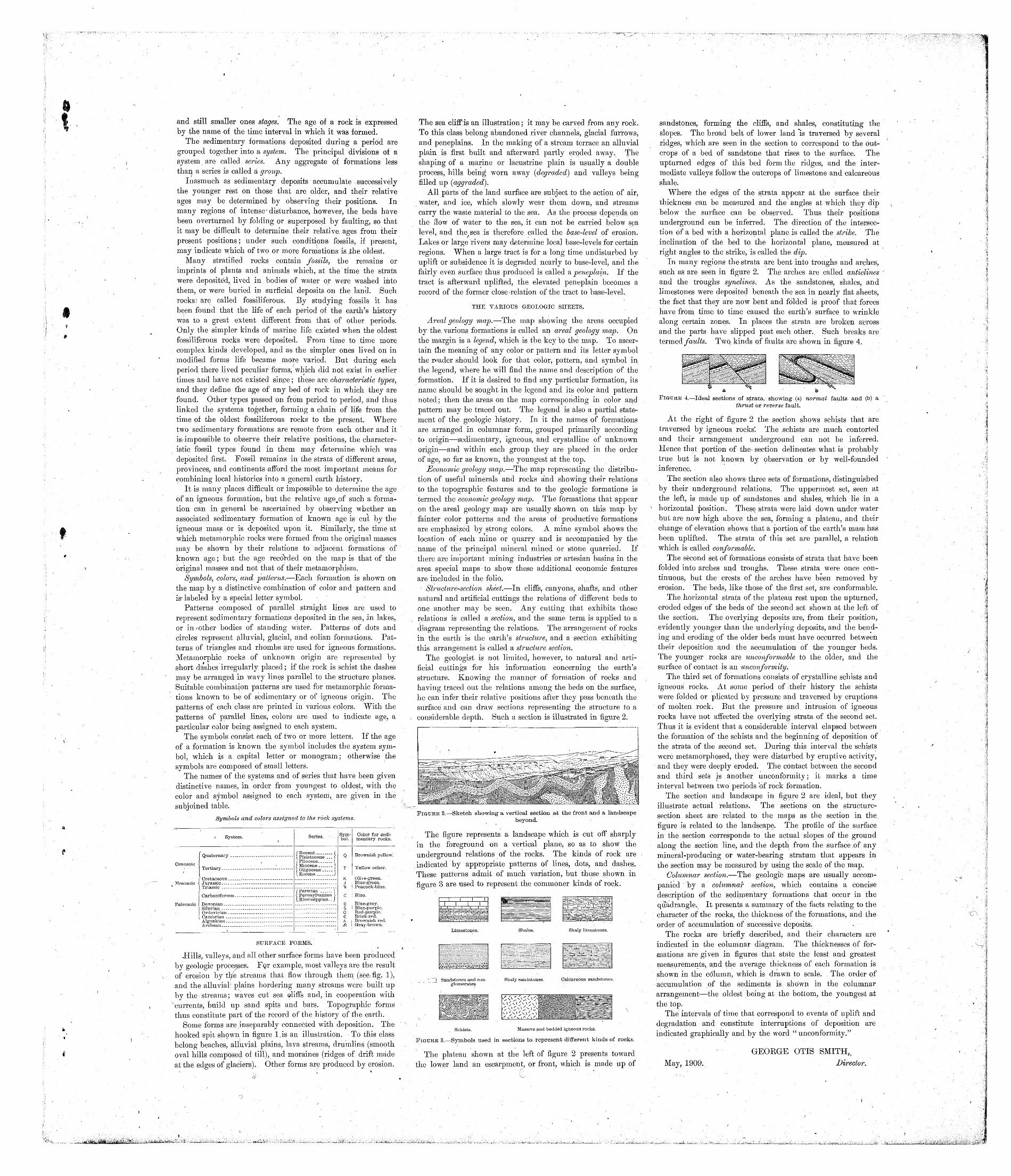
The geologist is not limited, however, to natural and arti ficial cuttings for his information concerning the earth's structure. Knowing the manner of formation of rocks and having traced out the relations among the beds on the surface, he can infer their relative positions after they pass beneath the surface and can draw sections representing the structure to a considerable depth. Such a section is illustrated in figure 2.
FIGURE 2. Sketch showing a vertical section at the front and a landscapebeyond.
The figure represents a landscape which is cut off sharply in the foreground on a vertical plane, so as to show the underground relations of the rocks. The kinds of rock are indicated by appropriate patterns of lines, dots, and dashes. These patterns admit of much variation, but those shown in figure 3 are used to represent the commoner kinds of rock.
Shales.
Shaly sandstones.
Schists. Massive and bedded igneous rocks.
sandstones, forming the cliffs, and shales, constituting the slopes. The broad belt of lower land is traversed by several ridges, which are seen in the section to correspond to the out crops of a bed of sandstone that rises to the surface. The upturned edges of this bed form the ridges, and the inter mediate valleys follow the outcrops of limestone and calcareous shale.
Where the edges of the strata appear at the surface their thickness can be measured and the angles at which they dip below the surface can be observed. Thus their positions underground can be inferred. The direction of the intersec tion of a bed with a horizontal plane, is called the strike. The inclination of the bed to the horizontal plane, measured at right angles to the strike, is called the dip.
In many regions the strata are bent into troughs and arches, such as are seen in figure 2. The arches are called anticlines and the troughs synclines. As the sandstones, shales, and limestones were deposited beneath the sea in nearly flat sheets, the fact that they are now bent and folded is proof that forces have from time to time caused the earth's surface to wrinkle along certain zones. In places the strata are broken across and the parts have slipped past each other. Such breaks are termed faults. Two. kinds of faults are shown in figure 4.
FIGURE 3. Symbols used in sections to represent different kinds of rocks.
The plateau shown at the left of figure 2 presents toward the lower land an escarpment, or front, which is made up of
a bFIGURE 4. Ideal sections of strata, showing (a) normal faults and (b) a
thrust or reverse fault.
At the right of figure 2 the section shows schists that are traversed by igneous rocks'. The : schists are much contorted and their arrangement underground can not be inferred. Hence that portion of the- section delineates.what is probably true but is not known by observation or by well-founded inference.
The section also shows-three sets of formations, distinguished by their underground relations. The uppermost set, seen at the left, is made up of sandstones and shales, which lie in a horizontal position. These strata were laid down under water but are now high above the sea, forming a plateau, and their change of elevation shows that a portion of the earth's mass has been uplifted. The strata of this set are parallel, a relation which is called conformable. .
The second set of formations consists of strata that have been folded into arches and troughs. These strata were once con tinuous, but the crests of the arches have been removed by erosion. The beds, like those of the first set, are conformable.
The horizontal strata of the plateau rest upon the upturned, eroded edges of the beds of the second set shown at the left of the section. The overlying deposits are, from their position, evidently younger than the underlying deposits, and the bend ing and eroding of the older beds must have occurred between their deposition and the accumulation of the younger beds. The younger rocks are unconformable to the older, and the surface of contact is an unconformity.
The third set of formations consists of crystalline schists and igneous rocks. At some period of ; their history the "schists were folded or plicated by pressure and traversed by eruptions of molten rock. But the pressure and intrusion of igneous rocks have not affected the overlying strata of the second set. Thus it is evident that a considerable interval elapsed between the formation of the schists and the beginning of deposition of the strata of the second set. During this interval the schists were metamorphosed, they were disturbed by eruptive activity, and they were deeply eroded. The contact between the second and third sets js another unconformity; it marks a time interval between two periods of rock formation.
The section and landscape in figure 2 are ideal, but they illustrate actual relations. The sections on the structure- section sheet are related to the maps as the section in the figure is related to the landscape. The profile of the surface in the section corresponds to the actual slopes of the ground along the section line, and the depth from the surface .of any mineral-producing or water-bearing stratum that appears in the section may be measured by using the scale of the map.
Columnar section. The geologic maps are usually accom panied by a columnar section, which contains a concise description of the sedimentary formations that occur in the quadrangle^ It presents a summary of the facts relating to the character .of the rocks, the thickness of the formations, and the order of accumulation of successive deposits.
The rocks are briefly described, and their characters are indicated in the columnar diagram. The thicknesses of for mations are given in figures that state the least and greatest measurements, and the average thickness of each formation is shown in the column, which is drawn to scale. The order of accumulation of the sediments is shown in the columnar arrangement the oldest being at the bottom, the youngest at the top.
The intervals of time that correspond to events of uplift and degradation and constitute interruptions of deposition are indicated graphically and by the word "unconformity."
May, 1909.
GEORGE OTIS SMITH, ?Director.
No.*
tl1915U
5t617T8
1910
tiltl2
13.14
.[1516IT18192021
,222524252627282930313233343536373839404142434445
* 464748495051
' 52
5354555657585960616263646566676869707179 4*
74757677787q
on81 !QO
oz
fi4
Name of folio.
Livingston ...........Ringgold . . .... .:>. ....Placerville . .... . . . . . .Kingston ............Sacramento ........ . .Chattanooga . ... . . . . . .Pikes Peak .... ,,. .Sewanee ............Anthracite-Crested Butte . .Harpers Ferry . . . ... . .Jackson ............Estillville '. . . . . . ... . .Fredericksburg ........Staunton ............Lassen Peak .........Knoxville ...........Marysville . . . . . . . . ...Srriartsville ..........Stevenson ...........Cleveland ...........Pikeville ............McMinnville ....../...Nomini . .-"'. ..........Three Forks ..........
. Loudon .............Pocahontas ..........Morristown ..........Piedmont ...........Nevada City Special .....Yellowstone National Park .
/Pyramid Peak . . . . . . .Franklin ............Briceville ...........Buckhannon ..........Gadsden ....... . '. . . .Pueblo .Downieville ..........Butte Special . . . . . .....Truckee ............Wartburg ............Sonora .............Nueces .............Bidwell Bar .... . . ....Tazewell ............Boise ..............Richmond . . . . .... . . .London ..............Tenmile District Special . . .Roseburg ...........Holyoke ............Big Trees ...........Absaroka ............Standingstone .........
, Tacoma - . . ...Fort Bentdn ..........Little Belt Mountains ....Telluride ............Elmoro .............Bristol .............La Plata ............Monterey ...........Menominee Special ......Mother Lode District ....Uvalde . . ...........Tintic Special .........Colfax .............Danville ............Walsenburg ..........Huntington ..........Washington ..........Spanish Peaks ........Charleston ...........Coos Bay ...........Goalgate ............Maynardville .........Austin .............Raleigh ..............Rome ..............Atoka ..............Norfolk .............*Chicago ............Masontown-Uniontown . . .New York City ........Ditney .............
State.
. *.-
Montana ............(^ OAT"mj3 1 onnococio
California ..... . .....Tennessee ...........California . .Tennessee ............
. '. Colorado <; . . ..,; . . ...Tennessee ... . .....Colorado ........:...Va.-Md.-W. Va. ...California ...........Ky.-Va.-Tenn. ........Virginia-Maryland . . . . . .Virginia-West Virginia ....California ...........Tennessee-North Carolina . .California ...........California ............Ala.-Ga.-Tenn. ........Tennessee ...........Tennessee' ...........Tennessee ...........Maryland-Virginia ......Montana ............Tennessee ...........Virginia-West Virginia ....Tennessee ...........West Virginia-Maryland . . .California ...........Wyoming ...........California ...........West Virginia-Virginia ....Tennessee ...........WesttVirginia .........Alabama . . .Colorado ............California ^ ..........MontanaCalifornia ...........Tennessee ...........California ' . .Texas .............California ...........Virginia-West Virginia . . . .Idaho- .....Kentucky .......... If"Kentucky ...........Colorado ... . ...Oregon .............Massachusetts-Connecticut .California ............Wyoming ............Tennessee . . . . . . . . .Washington ...,....,.Montana ............Montana ............Colorado ............Colorado ............Virginia-Tennessee ......Colorado ............Virginia-West Virginia ....Michigan ............California , . . . ....Texas .............Utah ..............California ...........Illinois-Indiana ........Colorado ............West Virginia-Ohio . .....D. G.-Va.-Md. . I .......Colorado ............West Virginia . . . . . ' . . . .Oregon .............Indian Territory .. ......Tennessee ...........Texas ......;......West Virginia . . ... .Georgia- Alabama ... ...Indian Territory ........Virginia-North Carolina ...Illinois-Indiana ........Pennsylvania .........New York-New Jersey . . .Indiana .............
Price.f
Gents. 25252525252525255025252525 .252525252525252525252525252525505025OR
25252525252525252525252525252525252525 N25252525252525252525255025'
2525252525502525252525252525252550255025
No.*
8586878889909192939495969798
. 991001011021031041051061071081091101111121131141151161171181 191201211221231241251261271281291301511321351 S4»135136137138139
V140*if^ w14^1. "-%, 142 ''
145144145 1 4fi14714814Qi Rn1 R1
1 R9
155i R41 RP?1 ^R
1571 RR
1 *3Q
1601611 R9163164165166167168
\ Name of folio.
Oelrichs ............Ellensburg .......Gamp Clarke ... . .Scotts Bluff ..........Port Orford ..........Cranberry ...........Hartville ............Gaines .............Elkland-Tioga ...Brownsville-Gonnellsville . .Columbia ...Olivet. ........ . .,.. . .Parker .... ... . ... . .Tishomingo .... . . . . . .Mitchell ............Alexandria ...........San Luis ............Indiana ....Nampa .............Silver City ...........Patoka .............Mount Stuart .........Newcastle ...........Edgemont ...........Gottonwood Falls .......Latrobe .....Globe ..............Bisbee .............Huron .............De Smet ............Kittanning ...........Asheville ............Gasselton-Fargo .......Greeneville ..........Fayetteville ....'......Silverton ............Waynesburg . . . . '.Tahlequah ...........Elders Ridge .........Mount Mitchell .........Rural Valley .........Bradshaw Mountains .....Sundance .......Aladdin .............Clifton ..... , . ......Rico ..............Needle Mountains . . . .Muscogee ...........Ebensburg ...........Beaver .............Nepesta ............St. Marys .Dover .............Redding ............
. Snoqualmie ..........Milwaukee Special .....
" Bald Mountain-Dayton ...V Cloud Peak-Fort McKinney .
Nantahala ...........Amity .............Lancaster-Mineral Point . . Rogersville ..........Pisgah .............Joplin District ........Penobscot Bay ........Devils Tower .........Roan Mountain ........Patuxent ...........Ouray .............^ATin<5lnw
Ann Arbor ...........Elk Point ...../.,...Passaic ............Rockland ...........Independence .........Accident-Grantsville .....Franklin Furnace . . . . .Philadelphia ..........Sa'nta Cruz ..........
' Belle Fourche .'......,.Aberdeen-Redfield ,.,- ....El Paso ............Trenton , . . ..........Jamestown-Tower ......
State.
South Dakota-Nebraska . . .Washington ..........Nebraska ...........Nebraska ...........Oregon .............North Carolina-Tennessee . .Wyoming. ...........Pennsylvania-New York ...Pennsylvania .........Pennsylvania .........Tennessee ...........
. South Dakota . . ... . ....South Dakota . . : . . . .-. .Indian Territory . . . . .' . . .South Dakota .........South Dakota .........California ...........Pennsylvania .........Idaho-Oregon .........Id^ho ..............Indiana-Illinois ........Washington ..........Wyoming-South-Dakota . . .South Dakota-Nebraska .Kansas .............Pennsylvania .........Arizona. ............Arizona .............South Dakota .........South Dakota .........Pennsylvania .........North Carolina-Tennessee . .North Dakota-Minnesota . .Tennessee-North Carolina . .Arkansas-Missouri ......Colorado ............Pennsylvania . . . ... . ...Indian Territory-Arkansas . .Pennsylvania .........North Carolina-Tennessee . .Pennsylvania .........Arizona. ............Wyoming-South Dakota ...Wyo.-S. Dak.-Mont. . ... .Arizona. ............Colorado ............Colorado ...........Indian Territory .......Pennsylvania .Pennsylvania .........Colorado ......Maryland- Virginia ......Del.-Md.-N. J. . ........California ...........Washington ..........Wisconsin ...........Wyoming. ...........Wyoming ............North Carolina-Tennessee . .Pennsylvania . . . . . . . . .Wisconsin-Iowa-Illinois ... Pennsylvania .........N. Garolina-S. Carolina . . .Missouri-Kansas . .-. ... . .Maine .............Wyoming ...........Tennessee-North Carolina .Md.-D. G. ..... ..... . . .Colorado ............Arkansas-Indian Territory .Michigan ............S. Dak.-Nebr.-Iowa .....New Jersey-New York . . .Maine .............Kansas ............-Md.-Pa.-W. Va. ........New Jersey ..........Pa.-N. J.-Del. .........California ............South Dakota .........South Dakota .........Texas .............New Jersey-Pennsylvania . .North Dakota .........
Price.t
Cents. 252525252525252525252525
' :-m!^:'-:.2£Hl-
252525252525 ,2525252525252525252525252525252525252525252525252525252525252525252525252525252525OR
255025259«,
25252525
>252525OR
25OR
50252525OR
OR
25
* Order by number. ',-f Payment must be made by money order or in cash.\ These folios are out of stock.
,Circulars showing the location of the area covered by any of the above folios, as well as information concerning topographic maps and other publications of the Geological Survey, may be had on application to the Director, United States Geological Survey, Washington, D. G.