geophysical investigations in the el-wad cave, mt. carmel, israel
TRANSCRIPT
Geophysical Investigations in the el-Wad Cave, Mt. Carmel, Israel
Mina Weinstein-Evron Zinman Institute of Archaeology, University of Haifa, Mt. Carmel, Haifa 31905, Israel
Yossi Mart National Institute of Oceanography, IOLR, Tel Shikmona, Haifa 31 080, Israel
Alex Beck Institute of Petroleum Research and Geophysics, Holon, Israel
Measurements ofthe thickness of the sediment fill in the el-Wad Cave, Mt. Carmel, Israel were carried out using seismic refraction methods. The cave is one of the famous Mt. Carmel Caves, where finds of Mousterian to Natufian prehistoric cultures had been encountered. The survey discovered a series of karatic pits in several chambers in the cave, with good correlation between the dimension of the chambers and the thickness of the sediment fill. The deepest pit was found in the inner part of the cave, where the oldest archaeological material could be expected.
INTRODUCTION The neighboring caves, Tabun, Skhul, and el-Wad, comprise the famous site
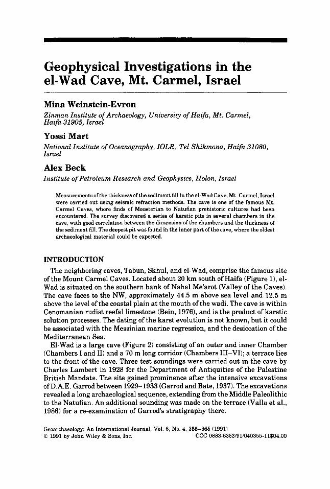
of the Mount Carmel Caves. Located about 20 km south of Haifa (Figure l), el- Wad is situated on the southern bank of Nahal Me'arot (Valley of the Caves). The cave faces to the NW, approximately 44.5 m above sea level and 12.5 m above the level of the coastal plain a t the mouth of the wadi. The cave is within Cenomanian rudist reefal limestone (Bein, 1976), and is the product of karstic solution processes. The dating of the karst evolution is not known, but it could be associated with the Messinian marine regression, and the desiccation of the Mediterranean Sea.
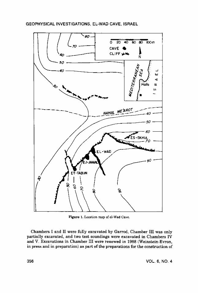
El-Wad is a large cave (Figure 2) consisting of an outer and inner Chamber (Chambers I and 11) and a 70 m long corridor (Chambers III-VI); a terrace lies to the front of the cave. Three test soundings were carried out in the cave by Charles Lambert in 1928 for the Department of Antiquities of the Palestine British Mandate. The site gained prominence after the intensive excavations of D.A.E. Garrod between 1929-1933 (Garrod and Bate, 1937). The excavations revealed a long archaeological sequence, extending from the Middle Paleolithic to the Natufian. An additional sounding was made on the terrace (Valla et al., 1986) for a re-examination of Garrod's stratigraphy there.
Geoarchaeology: An International Journal, Vol. 6, No. 4, 355-365 (1991) 0 1991 by John Wiley & Sons, Inc. CCC 0883-6353/91/040355-11$04.00
GEOPHYSICAL INVESTIGATIONS, EL-WAD CAVE, ISRAEL
---_ -.-
Figure 1. Location map of el-Wad Cave.
Chambers I and I1 were fully excavated by Garrod, Chamber I11 was only partially excavated, and two test soundings were excavated in Chambers IV and V. Excavations in Chamber I11 were renewed in 1988 (Weinstein-Evron, in press and in preparation) as part of the preparations for the construction of
356 VOL. 6, NO. 4
G EOPHY Sl CAL INVESTIGATIONS, EL- WAD CAVE, ISRAEL
Terrace
Figure 2. Map of el-Wad Cave, showing its chambers and its elongate configuration. (After Garrod and Bate, 1937).
a visitors’ center by the Nature Reserves Authority. Two seasons of excavation revealed Upper Paleolithic and Natufian layers, capped by mixed and recent remains. These excavations did not reach the bedrock.
In March 1989 a seismic refraction survey was conducted. The survey was
GEOARCHAEOLOGY: AN INTERNATIONAL JOURNAL 357
G EOPHY Sl CAL INVESTIGATIONS, EL- WAD CAVE, ISRAEL
restricted to Chambers III-V, since Chambers I and I1 had been nearly com- pletely excavated by Garrod and in Chamber VI the bedrock is exposed. The aim of the geophysical survey was twofold: first, to reconstruct the subsurface topography of the cave; second, to estimate the depth of the archaeological layers in Chamber 111, as well as in those areas of the cave which have not yet been tested.
In Israel, to date, seismic refraction surveys for archaeological research were conducted mainly on tells, such as Tell Nami (Beck, 19881, making el-Wad the first cave in which the method was successfully tested. The cave was found to be most suitable for seismic refraction surveys because of its size and geological setting. Its great length as well as its large chambers enabled us to obtain a considerable longitudinal profile, as well as a few transverse sections.
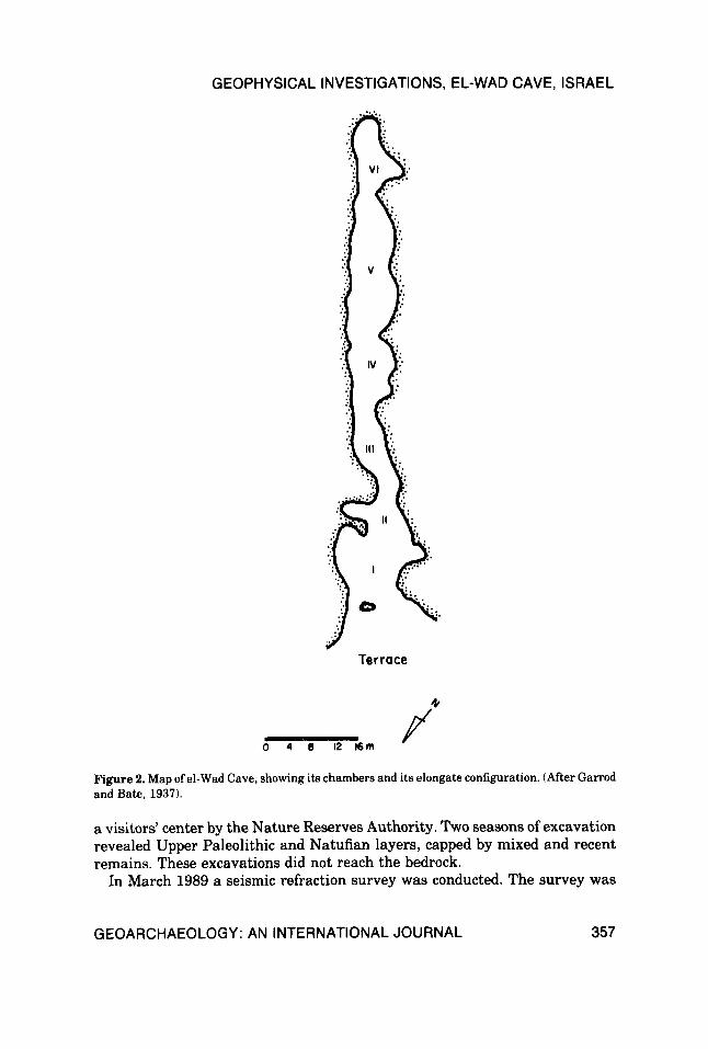
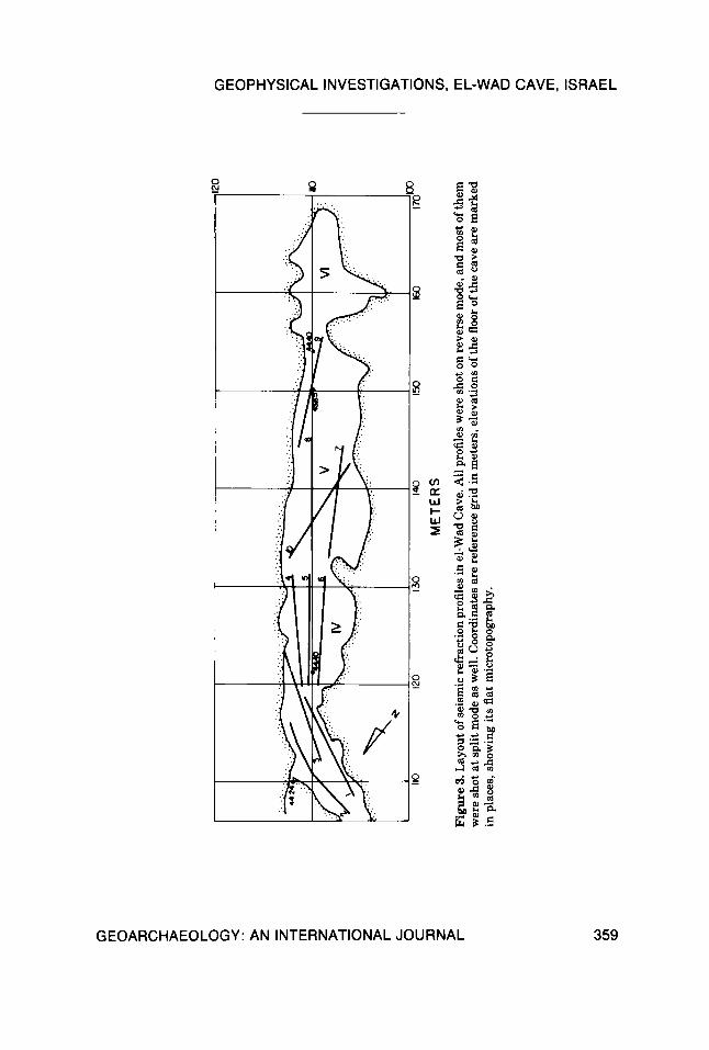
GEOPHYSICAL SETTING The seismic refraction survey of the el-Wad Cave consisted of 10 profiles
(Figure 3). Energy source was a 5 kg hammer on a metal plate, and receivers were 24 geophones with an internal frequency of 100 Hz, arranged in 24 channels. Spacing between geophones was kept to 0.5 m to achieve high resolu- tion. Shooting was at both ends of the profile, at the location of the external geophones, and supplementary shooting was run at split profile configurations, where the energy was released in the center of the profile.
Data processing was carried out according to the GRM method (Palmer, 1980, 1981). This processing procedure leads to reliable solutions of complex features, such as irregular configuration of seismic refractors, variable interval velocities or steeply dipping refractors. First arrivals were used to compute velocity analyses, time sections and subsequently, depth sections. Some basic input, such as the lithology of the underlying rock unit, derived from geological and archaeological observations, was introduced into the procedure.
The seismic refraction survey encountered two layers in the el-Wad cave, which were differentiated on the basis of varying seismic velocities. The upper layer, probably built of the unconsolidated sedimentary fill of the cave, shows seismic velocities of 500 to 750 m/sec. Interval seismic velocities in the second layer range from 2140 to an anomalously high 2550 m/sec. Seismic velocities exceeding 3000 m/sec were encountered a t the northern edge of the surveyed part of the cave. At this stage i t is difficult to determine whether these high velocities are associated with lateral lithological variation in the bedrock, or a sub-outcrop of a deeper geological layer. The slower velocities probably repre- sent occurrences of sedimentary fill, and the faster seismic velocities probably indicate bedrock. Outcrops of this layer a t the floor of the innermost chamber and along the walls of the cave show the Cenomanian reefal limestone that constitutes the escarpment of the cave opening. Although irregular, the contact of the limestone and the sedimentary fill was encountered’ ih most of the refraction profiles in the cave.
The profiles were set to measure the thickness of the upper sediment layer
358 VOL. 6, NO. 4
P - z -I 13 z
0
z
rn 3 t 6 t c n z
0
ul (0
ME
TER
S
Figure 3
. Lay
out o
f sei
smic
ref
ract
ion p
rofil
es in
el-W
ad C
ave.
All
prof
iles w
ere
shot
on
reve
rse
mod
e, a
nd m
ost o
f the
m
wer
e sh
ot a
t spl
it m
ode a
s wel
l. C
oord
inat
es ar
e re
fere
nce g
rid
in m
eter
s, e
leva
tion
s of t
he fl
oor o
f the
cav
e ar
e m
arke
d in
pla
ces,
sho
win
g it
s fla
t mic
roto
pogr
aphy
.
GEOPHYSICAL INVESTIGATIONS, EL-WAD CAVE, ISRAEL
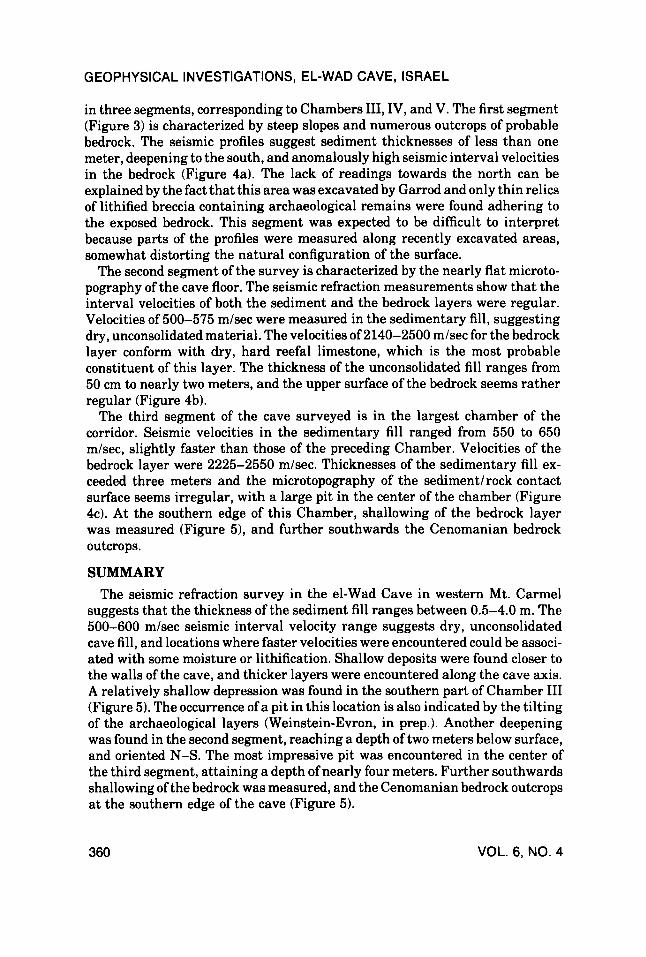
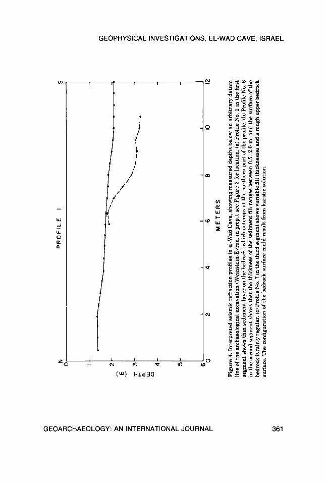
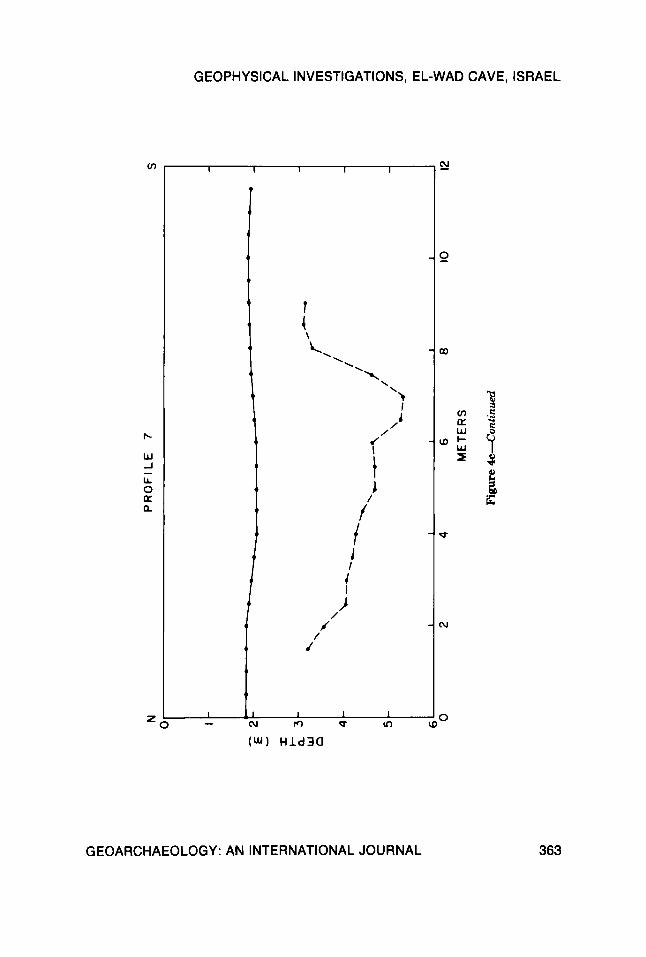
in three segments, corresponding to Chambers 111, IV, and V. The first segment (Figure 3) is characterized by steep slopes and numerous outcrops of probable bedrock. The seismic profiles suggest sediment thicknesses of less than one meter, deepening to the south, and anomalously high seismic interval velocities in the bedrock (Figure 4a). The lack of readings towards the north can be explained by the fact that this area was excavated by Garrod and only thin relics of lithified breccia containing archaeological remains were found adhering to the exposed bedrock. This segment was expected to be difficult t o interpret because parts of the profiles were measured along recently excavated areas, somewhat distorting the natural configuration of the surface.
The second segment of the survey is characterized by the nearly flat microto- pography of the cave floor. The seismic refraction measurements show that the interval velocities of both the sediment and the bedrock layers were regular. Velocities of 500-575 m/sec were measured in the sedimentary fill, suggesting dry, unconsolidated material. The velocities of 2140-2500 m/sec for the bedrock layer conform with dry, hard reefal limestone, which is the most probable constituent of this layer. The thickness of the unconsolidated fill ranges from 50 cm to nearly two meters, and the upper surface of the bedrock seems rather regular (Figure 4b).
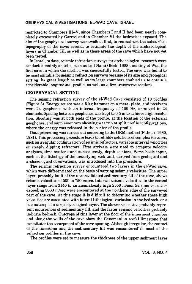
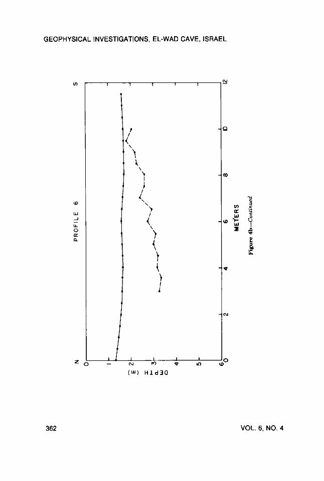
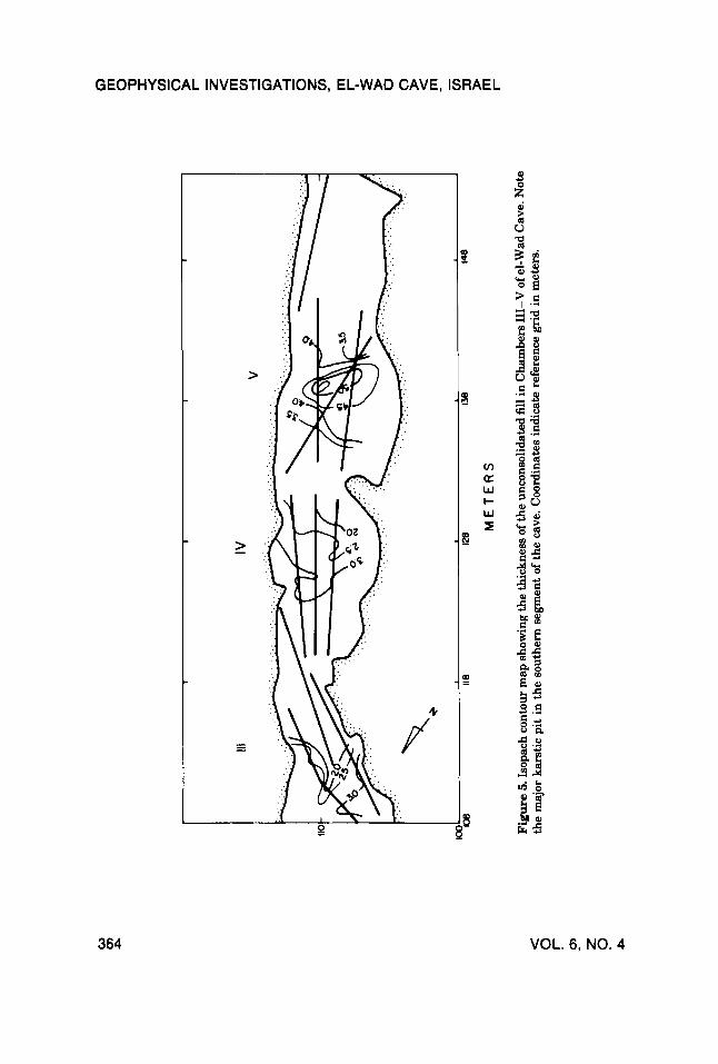
The third segment of the cave surveyed is in the largest chamber of the corridor. Seismic velocities in the sedimentary fill ranged from 550 to 650 m/sec, slightly faster than those of the preceding Chamber. Velocities of the bedrock layer were 2225-2550 m/sec. Thicknesses of the sedimentary fill ex- ceeded three meters and the microtopography of the sediment/rock contact surface seems irregular, with a large pit in the center of the chamber (Figure 4c). At the southern edge of this Chamber, shallowing of the bedrock layer was measured (Figure 5) , and further southwards the Cenomanian bedrock outcrops.
SUMMARY The seismic refraction survey in the el-Wad Cave in western Mt. Carmel
suggests that the thickness of the sediment fill ranges between 0.5-4.0 m. The 500-600 m/sec seismic interval velocity range suggests dry, unconsolidated cave fill, and locations where faster velocities were encountered could be associ- ated with some moisture or lithification. Shallow deposits were found closer to the walls of the cave, and thicker layers were encountered along the cave axis. A relatively shallow depression was found in the southern part of Chamber I11 (Figure 5 ) . The occurrence of a pit in this location is also indicated by the tilting of the archaeological layers (Weinstein-Evron, in prep.). Another deepening was found in the second segment, reaching a depth of two meters below surface, and oriented N-S. The most impressive pit was encountered in the center of the third segment, attaining a depth of nearly four meters. Further southwards shallowing of the bedrock was measured, and the Cenomanian bedrock outcrops at the southern edge of the cave (Figure 5) .
360 VOL. 6, NO. 4
G)
rn 0
D a
0 I
0
G)
D z i?i
5 5
2-
- E
I 3-
n
n - +
W
4-
5- N
PR
OF
ILE
I
S
1 I
1 1
1
\ \
0
rn 2 -
v) a
D
r
rn
GEOPHYSICAL INVESTIGATIONS, EL-WAD CAVE, ISRAEL
1 1 I I I
t
i '\
\ \
362 VOL. 6, NO. 4
GEOPHYSICAL INVESTIGATIONS, EL-WAD CAVE, ISRAEL
1 /
/ 4 I
t f /
1
b
1 I 4 I
/' /
/
GEOARCHAEOLOGY: AN INTERNATIONAL JOURNAL 363
d !-
It
111
I
IV
v
?.-d
..
.
..
.
...
..
.
..
......
......
......
......
......
......
......
. .
..
..
..
....
....
....
....
..
5h
-
....
....
. ..
...
- 35
'e
118
128
UB
ME
TE
RS
148
Figure 5
. Iso
pach
con
tour
map
sho
win
g th
e th
ickn
ess o
f the
unc
onso
lidat
ed fi
ll in
Cha
mbe
rs II-V o
f el-W
ad C
ave.
Not
e th
e m
ajor
kar
stic
pit
in th
e so
uthe
rn se
gmen
t of t
he c
ave.
Coo
rdin
ates
indi
cate
ref
eren
ce g
rid
in m
eter
s.
0
rn z
Z 0
P

GEOPHYSICAL INVESTIGATIONS, EL-WAD CAVE, ISRAEL
The evolution of pits is most probably a result of the karstic origin of the cave. An additional pit, nearly nine meters deep, was excavated in the outer chamber (Garrod and Bate, 1937). Similar pits or swallow-holes were found in the neighboring Tabun Cave (Garrod and Bate, 1937; Jelinek et al., 19731, and are common in other caves in the area, such as Kebara (Laville and Goldberg, 1989). Correlation seems to occur between the size of the chambers and the depths of the pits.
The thickest sedimentary fill was found in Chamber V. Thus, based on former investigation in el-Wad, as well as in other caves, this is where the oldest archaeological layers are expected to occur. This would be the case, provided that prehistoric man inhabited the inner parts of the cave in almost total darkness.
We thank Dr. D. Kaufman for useful discussions and Prof. P. Goldberg for his comments. The survey was supported by the Nature Reserves Authority of Israel, and the Research Authority of Haifa University.
REFERENCES Bein, A. (1976). Rudistid fringing reefs of Cretaceous shallow carbonate platform of Israel. Bulletin
American Association of Petroleum Geologists 60, 258-272. Beck, A. (1988). A reconnaissance study using the seismic refraction method (GRM) at the Tel
Nami archaeological site. Institute for Petroleum Research and Geophysics Holon, Israel, Report 251/1936/88.
Garrod D.A.E., and Bate, D.M.A. (1937). The Stone Age ofMount Carmel. Oxford: Clarendon Press, Vol. I, 240 pp.
Jelinek, A.J., Farrand, W.R., Haas, G., Horowitz, A., and Goldberg, P. (1973). New excavations at theTabun Cave, Mount Carmel, Israel, 1967-1972: A preliminary report. Pakorient 1,151-183.
Laville, H., and Goldberg, P. (1989). The Collapse of the Mousterian Sedimentary Regime and the Beginning of the Upper Palaeolithic at Kebara Cave, Mount Carmel, in 0. Bar Yosef and B. Vandermeersch, Eds., Investigations in South Leuantine Prehistory. BAR International Series 497,75-95.
Palmer, D. (1980). The generalized reciprocal method for seismic refraction interpretation. Society of Exploration Geophysicists, Tulsa, OK, 49 pp.
Palmer, D. (1981). An introduction to the generalized reciprocal method for seismic refraction interpretation. Geophysics 48, 1508-1518.
Valla, F.R., Bar-Yosef, O., Smith, P., Tchernov, E., and Desse, J. (1986). Un Nouveau sondage sur la terrasse &el Ouad, Israel. Palbrient 12. 21-38.
Weinstein-Evron, M. New radiocarbon dates for the Early Natufian of el-Wad cave, Mt. Carmel, Israel. Paleorient (in press).
Received December 7 , 1989 Accepted for publication April 15, 1991
GEOARCHAEOLOGY: AN INTERNATIONAL JOURNAL 365