geology of the akitio area (1:50 000 metric sheet u25bd, east), northeastern wairarapa, new zealand
TRANSCRIPT
This article was downloaded by: [The UC Irvine Libraries]On: 20 October 2014, At: 06:09Publisher: Taylor & FrancisInforma Ltd Registered in England and Wales Registered Number: 1072954 Registered office: Mortimer House,37-41 Mortimer Street, London W1T 3JH, UK
New Zealand Journal of Geology and GeophysicsPublication details, including instructions for authors and subscription information:http://www.tandfonline.com/loi/tnzg20
Geology of the Akitio area (1:50 000 metric sheetU25BD, east), northeastern Wairarapa, New ZealandG. Neef aa Department of Applied Geology , University of New South Wales , P. O. Box 1, Kensington,NSW, 2033, AustraliaPublished online: 23 Mar 2010.
To cite this article: G. Neef (1992) Geology of the Akitio area (1:50 000 metric sheet U25BD, east), northeastern Wairarapa,New Zealand, New Zealand Journal of Geology and Geophysics, 35:4, 533-548, DOI: 10.1080/00288306.1992.9514546
To link to this article: http://dx.doi.org/10.1080/00288306.1992.9514546
PLEASE SCROLL DOWN FOR ARTICLE
Taylor & Francis makes every effort to ensure the accuracy of all the information (the “Content”) containedin the publications on our platform. However, Taylor & Francis, our agents, and our licensors make norepresentations or warranties whatsoever as to the accuracy, completeness, or suitability for any purpose ofthe Content. Any opinions and views expressed in this publication are the opinions and views of the authors,and are not the views of or endorsed by Taylor & Francis. The accuracy of the Content should not be reliedupon and should be independently verified with primary sources of information. Taylor and Francis shall not beliable for any losses, actions, claims, proceedings, demands, costs, expenses, damages, and other liabilitieswhatsoever or howsoever caused arising directly or indirectly in connection with, in relation to or arising out ofthe use of the Content.
This article may be used for research, teaching, and private study purposes. Any substantial or systematicreproduction, redistribution, reselling, loan, sub-licensing, systematic supply, or distribution in anyform to anyone is expressly forbidden. Terms & Conditions of access and use can be found at http://www.tandfonline.com/page/terms-and-conditions
New Zealand Journal of Geology and Geophysics, 1992, Vol. 35: 533-5480028-8306/92/3504-0533 $2.50/0 © The Royal Society of New Zealand 1992
533
Geology of the Akitio area (1:50 000 metric sheet U25BD, east),northeastern Wairarapa, New Zealand
G.NEEFDepartment of Applied GeologyUniversity of New South WalesP. O. Box 1Kensington NSW 2033, Australia
Abstract The Akitio area, located entirely within the eastcoast ranges, north Wairarapa, is largely composed ofCretaceous strata which overlie the westward-subductingPacific plate. The oldest strata, Pahaoa Group, composed ofindurated sandstone and mudstone of Early Cretaceous(Albian) age, are in the central part of the mapped areawithin the fault-bounded Owahanga Block. The SpringhillFormation, which follows, is restricted to one small outcropadjacent to a north-trending fault.
Younger Cretaceous (mid and Late Cretaceous) andPaleocene strata are mapped as Mangapurupuru Group(Kipihana and Te Mai Formations) and Tinui Group(Whangai and Waipawa Formations). These strata crop outlargely in the southern and eastern parts of the sheet district.However, the Whangai Formation is also mapped within, andto the west of, the Tinui Fault Complex.
The early Cenozoic Wanstead Formation is present locallyin the eastern part of the area mapped, and in two diapirs whichlie a short distance inland, and also within the Tinui FaultComplex. The highly calcareous Weber Formation is within,and to the west of, the Tinui Fault Complex, but is absent eastof the complex. The early Miocene Whakataki Formation,largely composed of Bouma sequences, is present along anortheast-trending narrow belt parallel to the shore, and asrafts within the Mt Cadmus Diapir, and in a small area west ofthe diapir. Strata of early-mid Miocene age crop out west ofthe Tinui Fault Complex, but marine strata younger thanmiddle Miocene are absent from the sheet district.
The most important structural element of the Akitio area isthe Tinui Fault Complex in the west. The Tinui Fault, andthose faults further to the west, is usually almost vertical,whereas faults to the east of the fault commonly dip c. 73° tothe west. Two, low-angle westward-dipping thrusts aremapped near Akitio Station. Diapirs, caused partly by intensecompression of the incompetent bentonitic WansteadFormation, are mapped near the coast and within the TinuiFault Complex near Mt Cadmus.
Keywords stratigraphy; structure; tectonics; diapirs;geological history; NZMS 260, U25 BD
INTRODUCTION
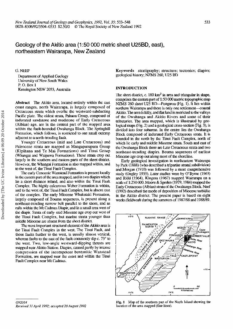
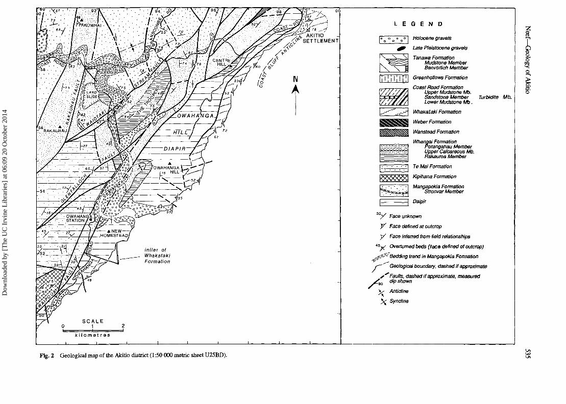
The sheet district, c. 180 km2 in area and triangular in shape,comprises the eastern part of 1:50 000 metric topographic mapNZMS 260 sheet U25 BD—Pongaroa (Fig. 1). It lies withinnorthern Wairarapa and there is only one settlement—coastalAkitio. The area is hilly, and flat land is restricted to the valleysof the Owahanga and Akitio Rivers and some of theirtributaries. The area mapped, which is illustrated by geo-logical maps (Fig. 2) and a geological cross-section (Fig. 3), isdivided into four subareas. In the centre lies the OwahangaBlock composed of indurated Early Cretaceous strata. It isbounded in the north by the Tinui Fault Complex, north ofwhich lie early and middle Miocene strata. South and east ofthe Owahanga Block there are Late Cretaceous strata and twonortheast-trending diapirs. Bouma sequences of earliestMiocene age crop out along most of the shoreline.
Early geological investigation in northeastern Wairarapaby Park (1888) (who described a tripartite stratal subdivision)and Morgan (1910) was followed by a more comprehensivestudy (Ongley 1935). Later studies were by O'Byrne (1963)and Ridd (1964). Kingma (1967) mapped Wairarapa on ascale of 1:250 000. Moore & Speden (1979,1984) mapped theEarly Cretaceous (Albian) strata of the Owahanga Block. Neef(1992) described the mode of deposition of Miocene turbiditein the Akitio district. The present paper is based on eightweeks fieldwork during the summers of 1987/88 and 1988/89.
kilometres
G92014Received 31 April 1992; accepted 20 August 1992
Fig. 1 Map of the southern part of the North Island showing thelocation of the area mapped (fine lines).
Dow
nloa
ded
by [
The
UC
Irv
ine
Lib
rari
es]
at 0
6:09
20
Oct
ober
201
4

f
sto
Dow
nloa
ded
by [
The
UC
Irv
ine
Lib
rari
es]
at 0
6:09
20
Oct
ober
201
4
AKITIOSETTLEMENT
inlier ofWhakatakiFormation
k i l o m e t r e s
N
00
L E G E N D
Holocene gravels
Late Pleistocene gravels
Tanawa FormationMudstone MemberBenvortich Member
Greenhollows Formation
Coast Road FormationUpper Mudstone Mb.Sandstone MemberLower Mudstone Mb.
Whakataki Formation
Weber Formation
Wanstead Formation
Whangai FormationPorangahau MemberUpper Calcareous Mb.Rakauroa Member
Te Mai Formation
Kipihana Formation
Mangapokia FormationStronvar Member
Daipir
Turbidite Mb.
Face unknown
y Face defined at outcrop
y Face inferred from field relationships
4 5 y Overturned beds (face defined of outcrop)
,??•?' Bedding trend in Mangapokia Formation
f^~ " Geological boundary, dashed if approximate
s** Faults, dashed if approximate, measureddip shown
Anticline
Syndine
o
Fig. 2 Geological map of the Akitio district (1:50 000 metric sheet U25BD).1^1
<J1
Dow
nloa
ded
by [
The
UC
Irv
ine
Lib
rari
es]
at 0
6:09
20
Oct
ober
201
4
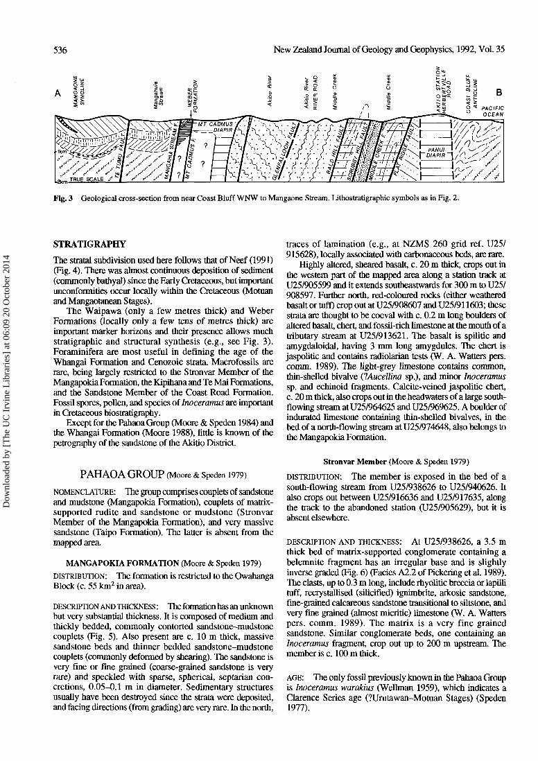
536 New Zealand Journal of Geology and Geophysics, 1992, Vol. 35
B
Fig. 3 Geological cross-section from near Coast Bluff WNW to Mangaone Stream. Lithostratigraphic symbols as in Fig. 2.
STRATIGRAPHY
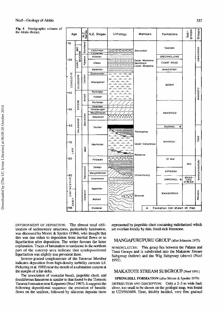
The stratal subdivision used here follows that of Neef (1991)(Fig. 4). There was almost continuous deposition of sediment(commonly bathyal) since the Early Cretaceous, but importantunconformities occur locally within the Cretaceous (Motuanand Mangaotanean Stages).
The Waipawa (only a few metres thick) and WeberFormations (locally only a few tens of metres thick) areimportant marker horizons and their presence allows muchstratigraphic and structural synthesis (e.g., see Fig. 3).Foraminifera are most useful in defining the age of theWhangai Formation and Cenozoic strata. Macrofossils arerare, being largely restricted to the Stronvar Member of theMangapokia Formation, the Kipihana and Te Mai Formations,and the Sandstone Member of the Coast Road Formation.Fossil spores, pollen, and species of Inoceramus are importantin Cretaceous biostratigraphy.
Except for the Pahaoa Group (Moore & Speden 1984) andthe Whangai Formation (Moore 1988), little is known of thepetrography of the sandstone of the Akitio District.
PAHAOA GROUP (Moore & Speden 1979)
NOMENCLATURE: The group comprises couplets of sandstoneand mudstone (Mangapokia Formation), couplets of matrix-supported rudite and sandstone or mudstone (StronvarMember of the Mangapokia Formation), and very massivesandstone (Taipo Formation). The latter is absent from themapped area.
MANGAPOKIA FORMATION (Moore & Speden 1979)
DISTRIBUTION: The formation is restricted to the OwahangaBlock (c. 55 km2 in area).
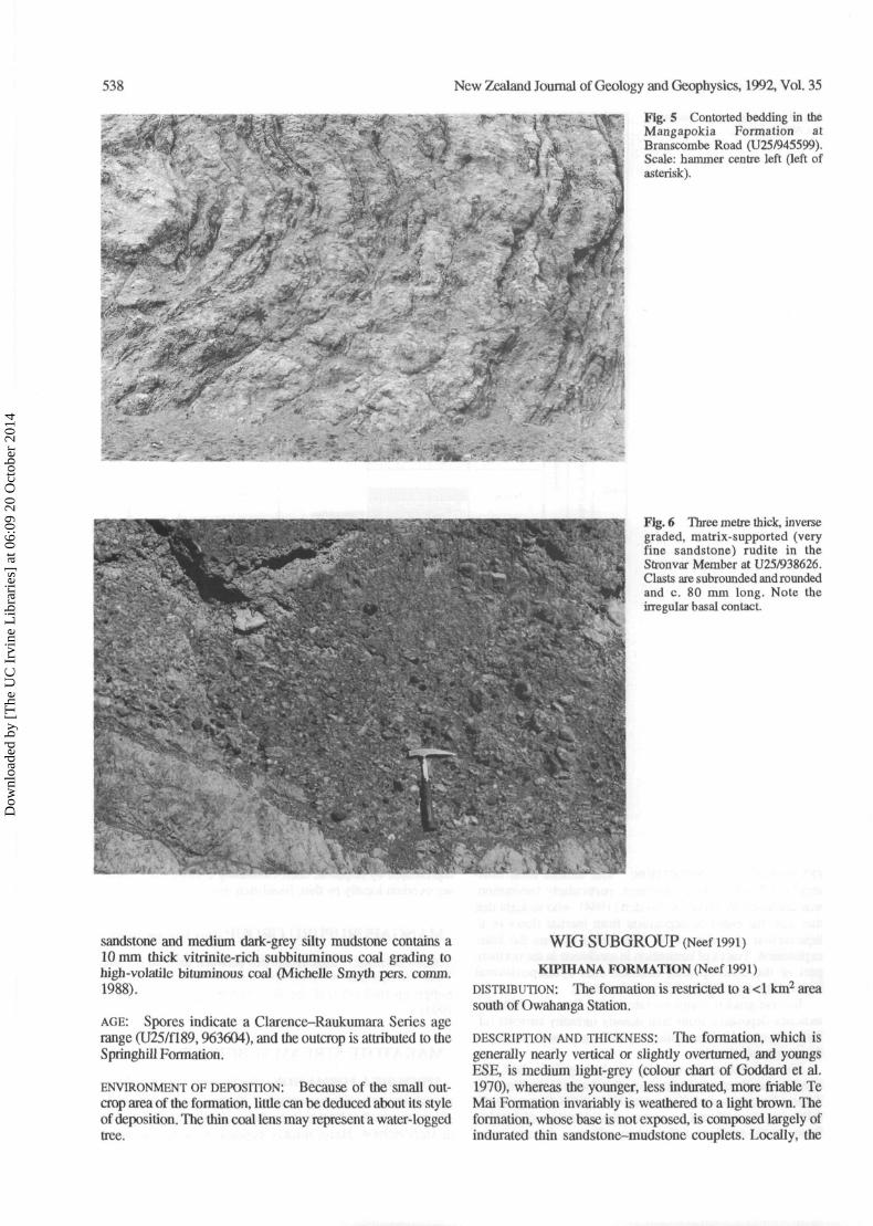
DESCRIPTION AND THICKNESS: The formation has an unknownbut very substantial thickness. It is composed of medium andthickly bedded, commonly contorted sandstone-mudstonecouplets (Fig. 5). Also present are c. 10 m thick, massivesandstone beds and thinner bedded sandstone-mudstonecouplets (commonly deformed by shearing). The sandstone isvery fine or fine grained (coarse-grained sandstone is veryrare) and speckled with sparse, spherical, septarian con-cretions, 0.05-0.1 m in diameter. Sedimentary structuresusually have been destroyed since the strata were deposited,and facing directions (from grading) are very rare. In the north,
traces of lamination (e.g., at NZMS 260 grid ref. U25/915628), locally associated with carbonaceous beds, are rare.
Highly altered, sheared basalt, c. 20 m thick, crops out inthe western part of the mapped area along a station track atU25/905599 and it extends southeastwards for 300 m to U25/908597. Further north, red-coloured rocks (either weatheredbasalt or tuff) crop out at U25/908607 and U25/911603; thesestrata are thought to be coeval with c. 0.2 m long boulders ofaltered basalt, chert, and fossil-rich limestone at the mouth of atributary stream at U25/913621. The basalt is spilitic andamygdaloidal, having 3 mm long amygdules. The chert isjaspolitic and contains radiolarian tests (W. A. Watters pers.comm. 1989). The light-grey limestone contains common,thin-shelled bivalve (lAucellina sp.), and minor Inoceramussp. and echinoid fragments. Calcite-veined jaspolitic chert,c. 20 m thick, also crops out in the headwaters of a large south-flowing stream at U25/964625 and U25/969625. A boulder ofindurated limestone containing thin-shelled bivalves, in thebed of a north-flowing stream at U25/974648, also belongs tothe Mangapokia Formation.
Stronvar Member (Moore & Speden 1979)
DISTRIBUTION: The member is exposed in the bed of asouth-flowing stream from U25/938626 to U25/940626. Italso crops out between U25/916636 and U25/917635, alongthe track to the abandoned station (U25/905629), but it isabsent elsewhere.
DESCRIPTION AND THICKNESS: At U25/938626, a 3.5 mthick bed of matrix-supported conglomerate containing abelemnite fragment has an irregular base and is slightlyinverse graded (Fig. 6) (Fades A2.2 of Pickering et al. 1989).The clasts, up to 0.3 m long, include rhyolitic breccia or lapillituff, recrystallised (silicified) ignimbrite, arkosic sandstone,fine-grained calcareous sandstone transitional to siltstone, andvery fine grained (almost micritic) limestone (W. A. Watterspers. comm. 1989). The matrix is a very fine grainedsandstone. Similar conglomerate beds, one containing anInoceramus fragment, crop out up to 200 m upstream. Themember is c. 100 m thick.
AGE: The only fossil previously known in the Pahaoa Groupis Inoceramus warakius (Wellman 1959), which indicates aClarence Series age (?Urutawan-Motuan Stages) (Speden1977).
Dow
nloa
ded
by [
The
UC
Irv
ine
Lib
rari
es]
at 0
6:09
20
Oct
ober
201
4
Neef—Geology of Akitio 537
Fig. 4 Stratigraphic column ofthe Akitio district.
-10
- 2 0
- 4 0
- 5 0
- 6 0
- 7 0
•80
90wooUJ
o
•110
' • %
N.Z. Stages
Lillburnian~Clltdenian~
AItonian
Otaian
Waitakian
Duntroonian
Whaingaroan
Runangan
Kaiatan
Bortonian
PoranganHeretaungan
Mangaorapan
Waipawan
L i t h o l o g y
I I I I I I I I. I I [ I I I I
i n I I m i I I i I I I
Members
Benvorllch
Upper MudstoneSandstoneLower Mudstone
Teurian
Haumurian
Piripauan
Teratan
Arowhanan
Ngaterlan
Motuan
Urutawan
Porangahau
Upper Calcareous
Rakauroa
Unconformity
Stronv ar
Formations
TAN AW A
GREENHOLLOWS
COAST ROAD
WHAKATAKI
WEBER
WANSTEAD
WAIPAWA *
WHANGAI
TE MAI
KIPIHANA
SPRINGHILL
MANGAPOKIA
' a
WIG
MAKA-TOTE
STREAM
O
* Formation not shown on map
ENVIRONMENT OF DEPOSITION: The almost total obli-teration of sedimentary structures, particularly lamination,was discussed by Moore & Speden (1984), who thought thatthis was due either to deposition from inertial flows or toliquefaction after deposition. The writer favours the latterexplanation. Traces of lamination in sandstone in the northernpart of the outcrop area indicate that syndepositionalliquefaction was slightly less prevalent there.
Inverse-graded conglomerate of the Stronvar Memberindicates deposition from high-density turbidity currents (cf.Pickering et al. 1989) near the mouth of a submarine canyon atthe margin of a fan delta.
The association of vesicular basalt, jaspolitic chert, andfossiliferous limestone is similar to that found in the ?JurassicTararua Formation near Kaiparoro (Neef 1967). It suggests thefollowing depositional sequence: the extrusion of basalticflows on the seafloor, followed by siliceous deposits (now
represented by jaspolitic chert containing radiolarians) whichare overlain locally by thin, fossil-rich limestone.
MANGAPURUPURU GROUP (after Johnston 1975)
NOMENCLATURE: This group lies between the Pahaoa andTinui Groups and is subdivided into the Makatote StreamSubgroup (below) and the Wig Subgroup (above) (Neef1991).
MAKATOTE STREAM SUBGROUP (Neef 1991)
SPRINGHILL FORMATION (after Moore & Speden 1979)DISTRIBUTION AND DESCRIPTION: Only a 2-3 m wide faultsliver, too small to be shown on the geologic map, was foundat U25/963604. Here, thickly bedded, very fine grained
Dow
nloa
ded
by [
The
UC
Irv
ine
Lib
rari
es]
at 0
6:09
20
Oct
ober
201
4
538 New Zealand Journal of Geology and Geophysics, 1992, Vol. 35
1*fiT\ Fig. 5 Contorted bedding in theMangapokia Formation atBranscombe Road (U25/945599).Scale: hammer centre left (left ofasterisk).
Fig. 6 Three metre thick, inversegraded, matrix-supported (veryfine sandstone) rudite in theStronvar Member at U25/938626.Oasts are subrounded and roundedand c. 80 mm long. Note theirregular basal contact.
sandstone and medium dark-grey silty mudstone contains a10 mm thick vitrinite-rich subbituminous coal grading tohigh-volatile bituminous coal (Michelle Smyth pers. comm.1988).
AGE: Spores indicate a Clarence-Raukumara Series agerange (U25/fl89,963604), and the outcrop is attributed to theSpringhill Formation.
ENVIRONMENT OF DEPOSITION: Because of the small out-crop area of the formation, little can be deduced about its styleof deposition. The thin coal lens may represent a water-loggedtree.
WIG SUBGROUP (Neef 1991)
KIPIHANA FORMATION (Neef 1991)DISTRIBUTION: The formation is restricted to a <1 km2 areasouth of Owahanga Station.
DESCRIPTION AND THICKNESS: The formation, which isgenerally nearly vertical or slightly overturned, and youngsESE, is medium light-grey (colour chart of Goddard et al.1970), whereas the younger, less indurated, more friable TeMai Formation invariably is weathered to a light brown. Theformation, whose base is not exposed, is composed largely ofindurated thin sandstone-mudstone couplets. Locally, the
Dow
nloa
ded
by [
The
UC
Irv
ine
Lib
rari
es]
at 0
6:09
20
Oct
ober
201
4
Neef—Geology of Akitio 539
thicker sandstone parts of the couplets (max. thickness 0.7 m)are carbonaceous and flute casted. Fossils are largelyInoceramus bicorrugatus (U25/f206, 905510) and somesinuous, bedding-parallel, tubular ichnofossils. The formation,which has faulted contacts to the east, north, and the west, is>600 m thick.
AGE: Inoceramus bicorrugatus is Mangaotanean in age,whereas Dimitobelusl ongleyi, known from the uppermostpart of the formation outside the mapped area, has a Teratan-Haumurian range. This suggests that the formation isMangaotanean - ?mid Teratan in age.
ENVIRONMENT OF DEPOSITION: The abundance of thinsandstone-mudstone couplets indicates deposition from distalturbidity currents. Common /. bicorrugatus suggests upperbathyal depths of deposition, and the carbonaceous content ofsome of the thicker sandstone probably indicates a forestedhinterland to the west.
TE MAI FORMATION (Neef 1991)DISTRIBUTION: The formation crops out in two main areas:(1) in the southwestern part of the mapped area nearOwahanga Station, where it has a distribution of c. 7 km2; and(2) as two NNE-trending belts east of the Akitio River.
DESCRIPTION: The formation, whose base is faulted out,lacks coarse rudite beds and is composed of poorly gradedsandstone-mudstone couplets which are thickly bedded inmost exposures. Sole structures are rare; one flute cast alongRiver Road (U25/995624) indicates northeastward (055°)flow. Most of the sandstone parts of the couplets are laminated(representing Tb of the Bouma sequence), but, at a fewlocalities, the sandstone parts show a well-developed Ta, Tb
and Tc sequence. The sandstone parts are usually carbon-aceous, fine or very fine-grained, and locally displayconvolute lamination and fragments of Inoceramus shells. Atsome localities north of Akitio Station, the formation containscoarse, faintly laminated sandstone beds up to 4 m thick.
Fresh outcrops show that some of the mudstone parts of thecouplets, medium dark-grey in colour, are bioturbated, andlocally Inoceramus sp. is present in the uppermost part of themudstones. The uppermost part of the formation, which cropsout southeast of the "Troopers" (local name) at U25/942572, iscomposed of a c. 20 m sequence of thinly bedded, mediumdark-grey mudstone and lighter coloured sandstone, overlainby c. 5 m of thickly bedded sandstone and mudstone, abovewhich lie unexposed strata c. 10 m thick.
THICKNESS: Because the formation is folded and lacksmarker horizons, and because contact with the underlyingKipihana Formation is absent, the thickness of the formation isuncertain. It is at least several hundred metres thick.
AGE: Age-diagonositic Inoceramus have not been found.However, near Mataikona, Inoceramus of Teratan andPiripauan age are known. The formation is considered to belargely Piripauan, extending down in to the ?middle part of theTeratan Stage.
ENVIRONMENT OF DEPOSITION: Rare flute casts and thicklybedded sandstone-mudstone couplets with abrupt basesindicate bathyal deposition from turbidite currents. Rarity ofrudite beds (which are more common in the Mataikona area)
indicates, as does the flute casts from River Road, that mostturbidity currents were derived from the southwest.
TTNUI GROUP (Johnston 1975)
WHANGAI FORMATION (Moore 1988)NOMENCLATURE: Moore (1988) subdivided the formation,which lacks macrofossils, into a western and eastern facies andthe following three members: (1) Rakauroa; (2) UpperCalcareous, and (3) Porangahau.
DISTRIBUTION: The formation is widespread within themapped area. It is probably best developed at the "Troopers".The Rakauroa and Upper Calcareous Members are mostcommon, whereas the Porangahau Member is restricted to ac. 2 km wide, north-trending belt north of Akitio.
DESCRIPTION:
Rakauroa Member. The Rakauroa Member is a siliceoussiltstone which is thickly bedded and locally containsglauconitic sandstone beds. It characteristically weathers to arusty colour. It is the typical Whangai siltstone of earlierworkers (Moore 1988).
Upper Calcareous Member. The member is medium-greymuddy siltstone which locally is well bedded and containssome glauconitic sandstone beds. Such beds crop out in thelower part of the member (e.g., a c. 1.5 m thick bed north of the"Troopers" at U25/937575) and in the upper part of themember (e.g., a c. 10 m thick glauconitic sandstone bed inMiddle Creek at U25/006656).
Porangahau Member. The Porangahau Member is thinlybedded, light-grey, and calcareous (Moore 1988).
THICKNESS: The Rakauroa Member is c. 370 m at the"Troopers", where it is overlain by the Upper CalcareousMember, which is at least c. 100 m thick (the mid and upperparts of the Whangai Formation being faulted out by theWaiotaki Stream Fault). Nearby, the Upper CalcareousMember is c. 520 m thick north of Pakowhai Trig, (where it isfully developed between the Rakauroa Member [below] andthe Waipawa Member [above]). Also, the Upper CalcareousMember may be c. 850 m thick in an area east of the"Troopers". The Porangahau Member is generally muchthinner than the other members. It is only c. 140 m thick at thenorthern boundary of the sheet district where it is fullydeveloped. The formation is substantially thicker thanMoore's (1988) estimate of 500 m.
BASAL CONTACT: The base of the formation, represented bythe Rakauroa Member, is conformable on the Te MaiFormation on the eastern scarp-side of the "Troopers" at U25/942572. However, at the northern boundary of the sheetdistrict, the formation is unconformable on the MangapokiaFormation.
AGE: The formation is Haumurian-Teurian in age (Moore1988).
ENVIRONMENT OF DEPOSITION: The abrupt change in sedi-mentation style from turbidite to low-velocity deposition at the
Dow
nloa
ded
by [
The
UC
Irv
ine
Lib
rari
es]
at 0
6:09
20
Oct
ober
201
4
540 New Zealand Journal of Geology and Geophysics, 1992, Vol. 35
base of the formation, may be due to the peneplanation of thecentral and western parts of the North Island (Stevens &Suggate 1978), causing a sudden decrease in the amount ofsediment available for redeposition. Late Cretaceous, siliceousWhangai-style deposition was widespread in the New Zealandarea (Moore 1988).
WAIPAWA FORMATION (after Hornibrook 1959)DESCRIPTION: The distinctive Waipawa Formation, whichhas abrupt lower and upper contacts, is very dark brown whenfresh but commonly it weathers yellow. It was found at sixlocalities. In the east it is c. 8 m thick in Middle Creek (U25/005656) where it is brownish-black in colour (5YR 2/1;Goddard et al. 1970). It is at least 1 m thick in the core of aNNE-trending syncline c. 1.2 km west of Panui Trig, at U25/018683, and c. 4 m thick west of Akitio School at U25/97600.Along the coast it is present within the Owahanga Hill Diapirat U25/926520. Inland it crops out adjacent to OwahangaRoad at U25/923564, where it is c. 4 m thick, and northeast ofPakowhai Trig., at U25/920604, where it is c. 4 m thick. Theformation is absent west of the Tinui Fault Complex.
AGE: The formation is Teurian in age (Moore et al. 1986).
ENVIRONMENT OF DEPOSITION: During the Paleocene,climate was warm, there being low pole-to-equator temper-ature gradients, and oceanic circulation was much reduced(i.e. the oceans were in a polytaxic mode; Fischer & Arthur1977). Within such an environment, deposition of organic-richsediments, like the bathyal Waipawa Formation, is favoured(Kennett 1982, p. 699).
WANSTEAD FORMATION(after Ongley 1936; Moore et al. 1986)
DISTRIBUTION: The formation occurs in two modes: autoch-thonous and allochthonous (diapiric). Small autochthonousoutliers of the formation are exposed in a c. 170 m reach ofMiddle Creek and in a 300 m wide NNE-trending belt nearScrubby Trig. Allochthonous parts of the formation occur inthe diapirs.
DESCRIPTION AND THICKNESS (AUTOCHTHONOUS): M u c h
of the formation is composed of medium grey, calcareousmudstone. In Middle Creek, the formation is probablyc. 200 m thick and is very poorly exposed. A 5 m thick pebblysandstone crops out c. 50 m above the base of the formation.Near Scrubby Creek, where the formation is c. 250 m thick, thereare spherical calcareous septarian concretions c. 1 m indiameter.
In the headwaters of Mangahuia Stream, sandstone withpebble and cobble beds (max. clast length 0.2 m; derived fromPahaoa Group and ?Whangai Formation) is attributed to theWanstead Formation because Cyclammina cf. grangei(U25/H97, 934650) has a Wanstead Formation age range(Hornibrook 1968). It is uncertain whether the pebbly sand-stone, which is c. 30 m thick, is unconformable on theMangapokia Formation or if it represents a raft within the MtCadmus Diapir.
DESCRIPTION (ALLOCHTONOUS): Blocks of medium-grainedsandstone, up to 10 m long, near the Owahanga River mouthare associated with Dannevirke Series strata (U25/f6014,933530). Glauconitic sandstone blocks, sometimes slicken-sided, and medium grey mudstone outcrop in the Panui Diapir.
These sandstone blocks, and also a large raft of sandstonewithin the Panui Diapir, are thought to be of Dannevirke Seriesage.
Beds of well-rounded conglomerate are present at threelocalities within the Panui and the Owahanga Hill Diapirs: (1)at the northeastern margin of the sheet district a 2.4 m thickbed is exposed along the track to Herbertville at U25/054697;(2) several hundred metres to the south, at U25/047695, a 2 mthick conglomerate bed contains clasts that are usually 20-70 mm long (max. clast size is 0.3 m); and (3) along a stationtrack near Owahanga Hill Trig., at U25/941545, a 3 m thickconglomerate bed contains pebbles (c. 70% by vol.), most ofwhich are rounded and disc shaped, with a maximum length of0.14 m; the matrix is a very fine sandstone. Clasts present atlocality (1) include: porphyritic microtonalite (or micro-diorite), altered tuff, feldsarenite (arkosic sandstone), lithicfeldsarenite, fine-grained greywacke, crushed greywacke withquartz veining, and vein quartz (W. A. Watters pers. comm.1988).
AGE: Dannevirke Series strata occur within the diapirs.Waipawan-Porangan rocks are in the southern part of theOwahanga Hill Diapir (U25/fl4, 933528; and U25/O6,925518). hi the Panui Diapir, Waipawan-Heretaungan strata(U25/f8,029667) crop out along the track to Panui Trig. In theMt Cadmus Diapir, a Waipawan age is determined at U25/f6531,961700.
ENViRONMENTOFDEPOsrnoN: The formation is hemipelagic,being deposited in deep water, largely from suspension. Therudite beds (like lithofacies 3 of Neef et al. 1985) indicate thepresence of early Cenozoic submarine canyons in the Akitioarea, and, perhaps, a more elevated hinterland than that of theLate Cretaceous.
WEBER FORMATION (Johnston 1975)
NOMENCLATURE: The Weber Series was first introduced byOngley & Williamson (1931) for a light-grey calcareousmudstone.
DISTRIBUTION: The formation is restricted to the Tinui FaultComplex and to two narrow belts that lie west of the complex.
DESCRIPTION AND THICKNESS: Between the MangahuiaStream and the Mt Cadmus Faults, the formation, which hasabrupt lower and upper contacts, is light grey and highlycalcareous. It lacks macrofossils and is only c. 35 m thick.Locally, thin glauconitic beds are present. It is much thicker,perhaps as thick as 200 m, within the Tinui Fault Complexnear the abandoned station.
BASAL CONTACT: Within the fault block delineated by theMagahuia Stream and the Mt Cadmus Faults, the WeberFormation is paraconformable on the Whangai Formation.
AGE: The formation is Kaiatan-Duntroonian in age (Mooreet al. 1986). Near Mt Cadmus, the uppermost part of theformation is early Waitakian (U25/fl91, 942671).
ENVIRONMENT OF DEPOSITION: Sample U25/fl91 indicatesmid-lower bathyal deposition. Abundant foraminifera andabsence of much sand is consistent with most of the NorthIsland lying below sea level (Stevens & Suggate 1978),ensuring that clastic sedimentation was at a minimum.
Dow
nloa
ded
by [
The
UC
Irv
ine
Lib
rari
es]
at 0
6:09
20
Oct
ober
201
4
Neef—Geology of Akitio 541
WHAKATAKI FORMATION (Johnston 1975)
DISTRIBUTION: The formation crops out in a c. 500 m widebelt along the shore from the northern boundary of the sheetdistrict to near the northern margin of the Owahanga Rivermouth at U25/946538. It is also present within the Tinui FaultComplex. West of the Tinui Fault Complex, it crops outbetween the Mt Cadmus and the Te Tumu Faults, and alsonear the abandoned station.
DESCRIPTION: The formation is composed of carbonaceous,graded beds (Bouma sequences) up to 4 m thick. Featurescharacteristic of turbidite deposition include flute casts (Fig.7), flame structures, and convolute lamination. Some of thethicker sandstone parts of the Bouma sequences, with well-developed Ta, Tb and Tc intervals (Fig. 8), are lenticular andvary in thickness over a distance of c. 70 m. Locally, thinBouma sequences composed of sandy parts 20-40 mm thick,and muddy parts 70-200 mm thick, form units several tens ofmetres thick.
In the south, near the Owahanga River mouth at U25/946538, the formation adjacent to the Owahanga Hill Diapircontains at least three, c. 2.5 m thick, >50 m long lenses ofclast-supported, disorganised rudite (commonly containingsubangular clasts of Whangai Formation; max. clast length1 m) (Fig. 9). West of the Tinui Fault Complex the formationis best exposed in Mangahuia Stream where Bouma sequencesare characterically 0.4 m thick.
The mineral content of Bouma sequences south of thesheet district indicate that the formation there was derivedfrom a Mesozoic greywacke source (Korsch & Roser 1986).
THICKNESS : Along the coast north of Akitio, where the baseand the top of the formation are unexposed, the formation is atleast 900 m thick. However, only c. 120 m of the lower part ofthe formation are exposed between the Mangahuia Stream andMt Cadmus Faults, and only c. 300 m of the upper part of theformation are exposed near the abandoned station.
AGE: Several samples were collected for foraminiferalcontent but none gave a precise age. As the uppermost part ofthe underlying Weber Formation (U25/fl91, 942671) is earlyWaitakian, and as foraminfera from the overlying Coast RoadFormation are Waitakian or Otaian in age, the WhakatakiFormation has a Waitakian-Otaian age range.
ENVIRONMENT OF DEPOSITION: The formation was depositedfrom turbidity currents that flowed ENE or NE on a deep-seaplain. South of Akitio, a flute cast indicates flow towards 075°and one groove has a 086° trend; north of Akitio, four flutecasts give a mean flow towards 048°, whereas three groovecasts have a 070° trend. In the south, at the margin of theOwahanga Hill Diapir, rudite lenses indicate that the diapirwas emergent during deposition of the formation. Wedging out ofrudite lenses indicates southeastward transport of the rudite.
OWAHANGA GROUP (Neef 1991)
NOMENCLATURE: In the Akitio area, the Owahanga Groupcomprises the Coast Road, Greenhollows, and TanawaFormations.
COAST ROAD FORMATION (Neef 1991)NOMENCLATURE: The formation is composed of the Sand-stone Member which is overlain and underlain by the Upper
Mudstone Member and the Lower Mudstone Members,respectively. Near Mangahuia Station the distal TurbiditeMember is mapped.
DISTRIBUTION: The formation crops out west of the TinuiFault Complex near the abandoned station, along MangahuiaStream, and between the Mt Cadmus Diapir and the MtCadmus Fault.
DESCRIPTION:
Lower Mudstone Member The member, c. 60 m thick, ismedium grey in colour and contains minor, c. 10 mm thick,very fine sandstone beds.
Sandstone Member The member is c. 10-30 m thick,massive, very fine grained, and contains some scatteredmacrofossils.
Upper Mudstone Member The member, c. 300 m thick,is like the Lower Mudstone Member in containing a fewc. 10 mm thick, very fine grained sandstone beds. Mudstoneof unknown thickness, which can not be attributed to either theLower Mudstone or Upper Mudstone Members, crops outalong Mangahuia Stream between the Te Tumu andMangahuia Stream Faults.
Turbidite Member Sandstone-mudstone couplets betweenthe Mt Cadmus Diapir and the Mt Cadmus Fault character-istically have Tb basal parts and 80-100 mm thick sandstoneparts followed by the 200-350 mm thick mudstone parts. Themember is c. 370 m thick.
AGE: Foraminifera from the Sandstone Member (U25/f217,908637) give a late Waitakian-Otaian age, whereas theforaminifera from the Upper Mudstone Member give a lateWaitakian-Otaian age for its lower part (U25/f219, 908640)and an early Altonian age for its uppermost part (U25/f218,909643). However, on the basis of the age of the formationnear Pongaroa, the formation is considered to be largelyOtaian, possibly ranging to the early Altonian.
ENVIRONMENT OF DEPOSITION: Foraminifera from theLower Mudstone Member (U25/f219) indicate mid-upperbathyal deposition (as does U25/fl92,933 674), whereas theSandstone Member has an upper bathyal to outer shelf depthrange (U25/f217). Foraminifera from the Upper MudstoneMember (U25/f218) indicate mid-lower bathyal deposition,and the mud-rich Turbidite Member represents mid-bathyal(U25/f 190,955692) deposition from distal turbidity currents.
GREENHOLLOWS FORMATION (Neef 1991)
DESCRIPTION AND THICKNESS: The formation, c. 250 mthick, is very poorly exposed within the mapped area.However, 3 m long, massive sandstone boulders attributed tothe formation are present along a station track at U25/919655.
AGE: The age of the Greenhollows Formation in the mappedarea is unknown but it is assumed to be Altonian as it is nearPongaroa.
ENVIRONMENT OF DEPOSITION: The formation is consideredto have been deposited from turbidity currents in a non-channellised sheet-sand environment (Neef 1992).
Dow
nloa
ded
by [
The
UC
Irv
ine
Lib
rari
es]
at 0
6:09
20
Oct
ober
201
4

542 New Zealand Journal of Geology and Geophysics, 1992, Vol. 35
Fig. 7 Large flute casts andchannelling at the base of a steeplydipping, 1.85 m thick, massiveturbidite in the WhakatakiFormation south of Akitio at U25/961561. Scale: hammer centreright (left of asterisk).
Fig. 8 Steeply dipping Boumasequences exposed in theWhakataki Formation on a wave-cut platform north of Akitio atU25/039648.
Fig. 9 Interbedded rudite andturbidite at the margin of theOwahanga Hill Diapir at U25/946538. Note the huge clast at the
-S top of a flow (under hammer) andthe irregular nature of the top of theflow.
Dow
nloa
ded
by [
The
UC
Irv
ine
Lib
rari
es]
at 0
6:09
20
Oct
ober
201
4
Neef—Geology of Akitio 543
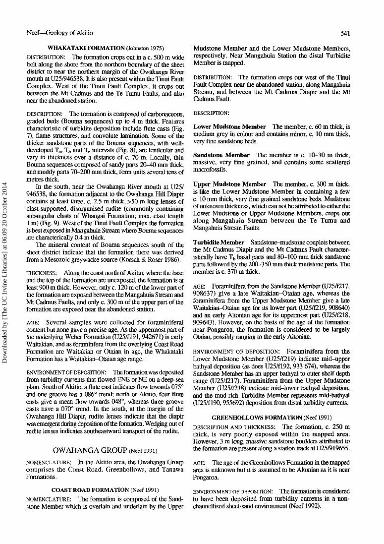
Fig. 10 Two, 4 m thick, slumpedstrata interbedded with Boumasequences in Mangaone Stream atU25/902673. Scale: pack, left ofasterisk, is 0.4 m long. Note thelenticular nature of some of thesandstone parts of the couplets andthe irregular upper contact of thelower slumped horizon.
TAN AW A FORMATION (redefined, Neef 1991)
NOMENCLATURE AND AGE: The formation, which overliesthe Greenhollows Formation, is composed of sandstone-mudstone couplets which are ?Altonian, Clifdenian, andLillburnian in the mapped area.
DISTRIBUTION: The formation has its largest outcrop west ofthe Te Tumu Fault and it is also present between the Te Tumuand the Mangahuia Stream Faults.
DESCRIPTION: The formation, which lacks macrofossils,usually consists of mud-rich, poorly graded, sandstone-mudstone couplets. The base of each couplet is abrupt;however, flute and groove casts are rare. Between the TeTumu and the Mangahuia Stream Faults, where the formationis at least 220 m thick, the lower part contains couplets wherethe sandstone parts are thin (c. 10 mm). The mid part of theformation has Bouma sequences that have thicker lencticularsandstone parts, commonly 300 mm thick, which showgrading, and there is one groove cast which trends at 023°.Locally, growth faults indicate syndepositional deformation,and a recumbent fold at U25/900670 indicates a northward-declined paleoslope. In the northern part of the outcrop area,the upper part of the formation contains sandstone-mudstonecouplets with thin sandstone parts.
West of the Te Tumu Fault, along Mangaone Stream,several outcrops atU25/911665 contain sinuous, subvertical,calcified burrows up to 2 m in length. About 350 m above thebase of the formation, there is a c. 3 m thick sandstone bed,which has a strike length of c. 3 km. Along the west limb of theMangaone Syncline, Bouma sequences show grading and areslumped, suggesting syndepositional growth of the MangaoneSyncline (Fig. 10).
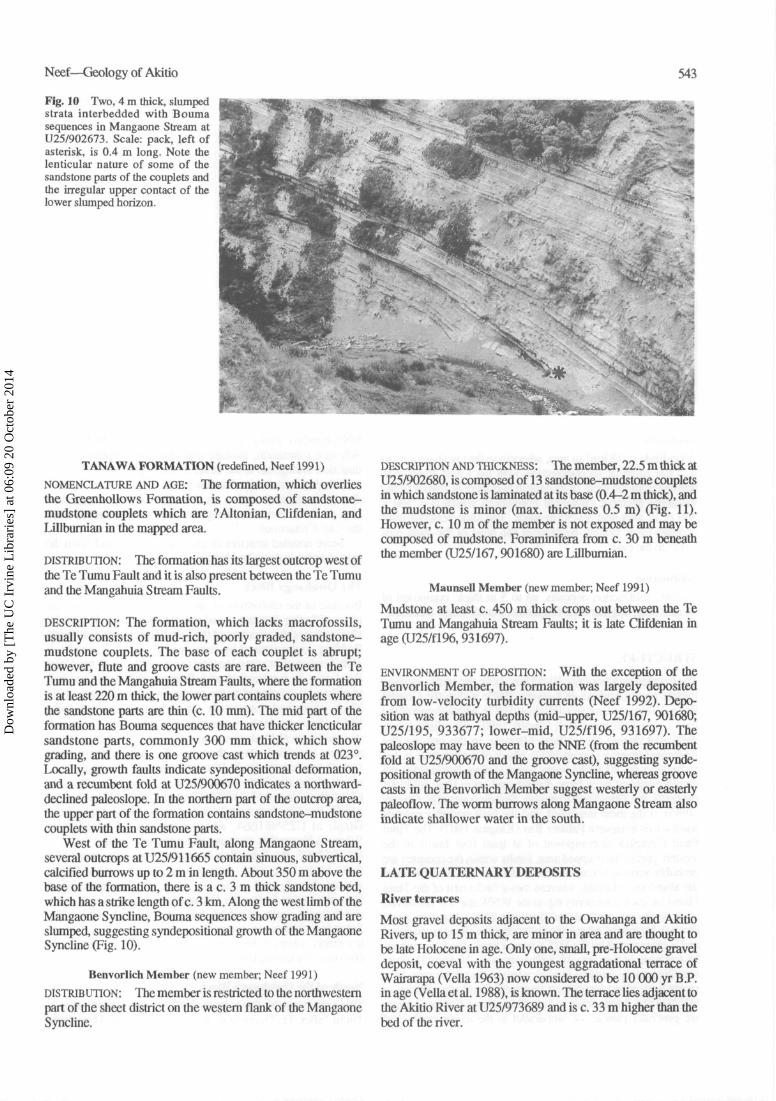
Benvorlich Member (new member; Neef 1991)
DISTRIBUTION: The member is restricted to the northwesternpart of the sheet district on the western flank of the MangaoneSyncline.
DESCRIPTION AND THICKNESS : The member, 22.5 m thick atU25/902680, is composed of 13 sandstone-mudstone coupletsin which sandstone is laminated at its base (0.4-2 m thick), andthe mudstone is minor (max. thickness 0.5 m) (Fig. 11).However, c. 10 m of the member is not exposed and may becomposed of mudstone. Foraminifera from c. 30 m beneaththe member (U25/167,901680) are Lillburnian.
Maunsell Member (new member; Neef 1991)
Mudstone at least c. 450 m thick crops out between the TeTumu and Mangahuia Stream Faults; it is late Clifdenian inage (U25/fl96,931697).
ENVIRONMENT OF DEPOSITION: With the exception of theBenvorlich Member, the formation was largely depositedfrom low-velocity turbidity currents (Neef 1992). Depo-sition was at bathyal depths (mid-upper, U25/167, 901680;U25/195, 933677; lower-mid, U25/fl96, 931697). Thepaleoslope may have been to the NNE (from the recumbentfold at U25/900670 and the groove cast), suggesting synde-positional growth of the Mangaone Syncline, whereas groovecasts in the Benvorlich Member suggest westerly or easterlypaleoflow. The worm burrows along Mangaone Stream alsoindicate shallower water in the south.
LATE QUATERNARY DEPOSITS
River terraces
Most gravel deposits adjacent to the Owahanga and AkitioRivers, up to 15 m thick, are minor in area and are thought tobe late Holocene in age. Only one, small, pre-Holocene graveldeposit, coeval with the youngest aggradational terrace ofWairarapa (Vella 1963) now considered to be 10 000 yr B.P.in age (Vella et al. 1988), is known. The terrace lies adjacent tothe Akitio River at U25/973689 and is c. 33 m higher than thebed of the river.
Dow
nloa
ded
by [
The
UC
Irv
ine
Lib
rari
es]
at 0
6:09
20
Oct
ober
201
4
544 New Zealand Journal of Geology and Geophysics, 1992, Vol. 35
Fig. 11 Benvorlich Member atMagaone Stream (U25/901681).
Landslide
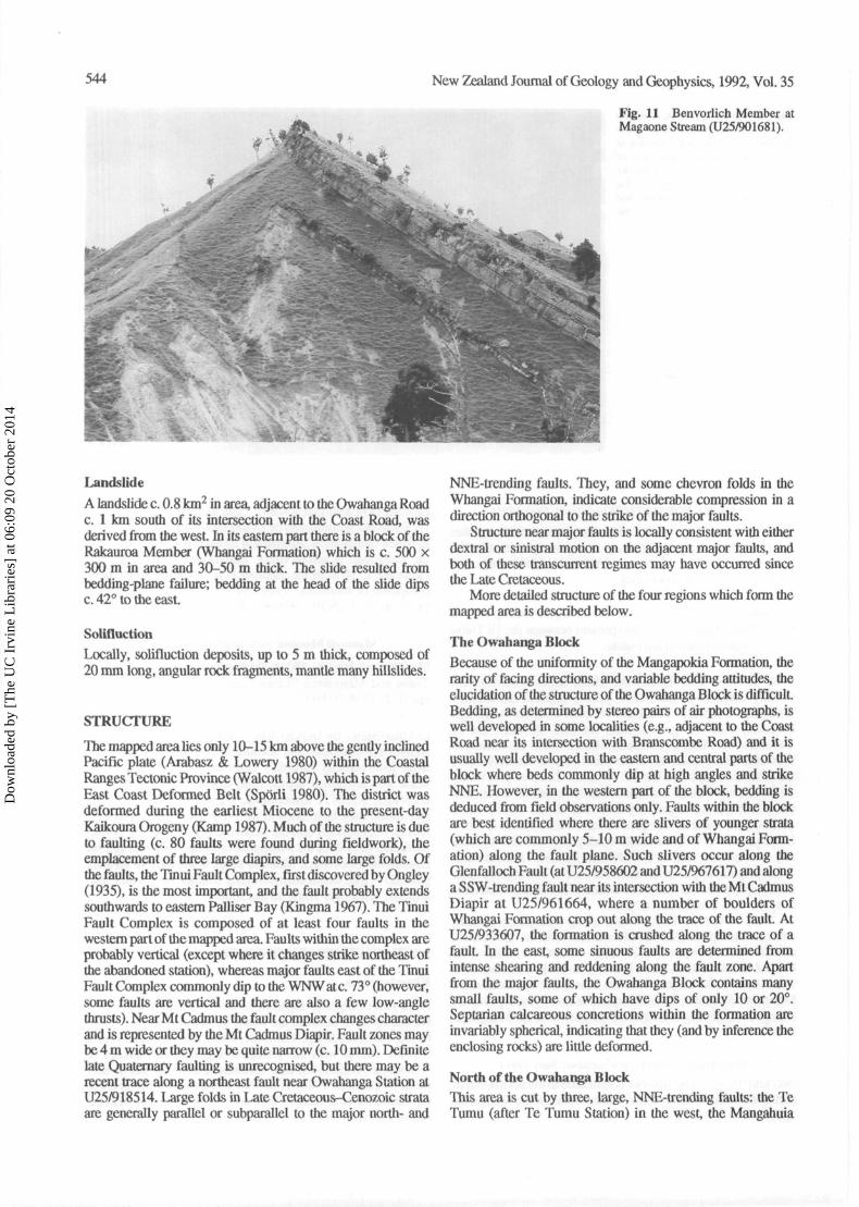
A landslide c. 0.8 km2 in area, adjacent to the Owahanga Roadc. 1 km south of its intersection with the Coast Road, wasderived from the west. In its eastern part there is a block of theRakauroa Member (Whangai Formation) which is c. 500 x300 m in area and 30-50 m thick. The slide resulted frombedding-plane failure; bedding at the head of the slide dipsc. 42° to the east.
Solifluction
Locally, solifluction deposits, up to 5 m thick, composed of20 mm long, angular rock fragments, mantle many hillslides.
STRUCTURE
The mapped area lies only 10-15 km above the gently inclinedPacific plate (Arabasz & Lowery 1980) within the CoastalRanges Tectonic Province (Walcott 1987), which is part of theEast Coast Deformed Belt (Sporli 1980). The district wasdeformed during the earliest Miocene to the present-dayKaikoura Orogeny (Kamp 1987). Much of the structure is dueto faulting (c. 80 faults were found during fieldwork), theemplacement of three large diapirs, and some large folds. Ofthe faults, the Tinui Fault Complex, first discovered by Ongley(1935), is the most important, and the fault probably extendssouthwards to eastern Palliser Bay (Kingma 1967). The TinuiFault Complex is composed of at least four faults in thewestern part of the mapped area. Faults within the complex areprobably vertical (except where it changes strike northeast ofthe abandoned station), whereas major faults east of the TinuiFault Complex commonly dip to the WNWatc. 73° (however,some faults are vertical and there are also a few low-anglethrusts). Near Mt Cadmus the fault complex changes characterand is represented by the Mt Cadmus Diapir. Fault zones maybe 4 m wide or they may be quite narrow (c. 10 mm). Definitelate Quaternary faulting is unrecognised, but there may be arecent trace along a northeast fault near Owahanga Station atU25/918514. Large folds in Late Cretaceous-Cenozoic strataare generally parallel or subparallel to the major north- and
NNE-trending faults. They, and some chevron folds in theWhangai Formation, indicate considerable compression in adirection orthogonal to the strike of the major faults.
Structure near major faults is locally consistent with eitherdextral or sinistral motion on the adjacent major faults, andboth of these transcurrent regimes may have occurred sincethe Late Cretaceous.
More detailed structure of the four regions which form themapped area is described below.
The Owahanga Block
Because of the uniformity of the Mangapokia Formation, therarity of facing directions, and variable bedding attitudes, theelucidation of the structure of the Owahanga Block is difficult.Bedding, as determined by stereo pairs of air photographs, iswell developed in some localities (e.g., adjacent to the CoastRoad near its intersection with Branscombe Road) and it isusually well developed in the eastern and central parts of theblock where beds commonly dip at high angles and strikeNNE. However, in the western part of the block, bedding isdeduced from field observations only. Faults within the blockare best identified where there are slivers of younger strata(which are commonly 5-10 m wide and of Whangai Form-ation) along the fault plane. Such slivers occur along theGlenfalloch Fault (at U25/958602 and U25/967617) and alonga SSW-trending fault near its intersection with the Mt CadmusDiapir at U25/961664, where a number of boulders ofWhangai Formation crop out along the trace of the fault. AtU25/933607, the formation is crushed along the trace of afault. In the east, some sinuous faults are determined fromintense shearing and reddening along the fault zone. Apartfrom the major faults, the Owahanga Block contains manysmall faults, some of which have dips of only 10 or 20°.Septarian calcareous concretions within the formation areinvariably spherical, indicating that they (and by inference theenclosing rocks) are little deformed.
North of the Owahanga BlockThis area is cut by three, large, NNE-trending faults: the TeTumu (after Te Tumu Station) in the west, the Mangahuia
Dow
nloa
ded
by [
The
UC
Irv
ine
Lib
rari
es]
at 0
6:09
20
Oct
ober
201
4
Neef—Geology of Akitio 545
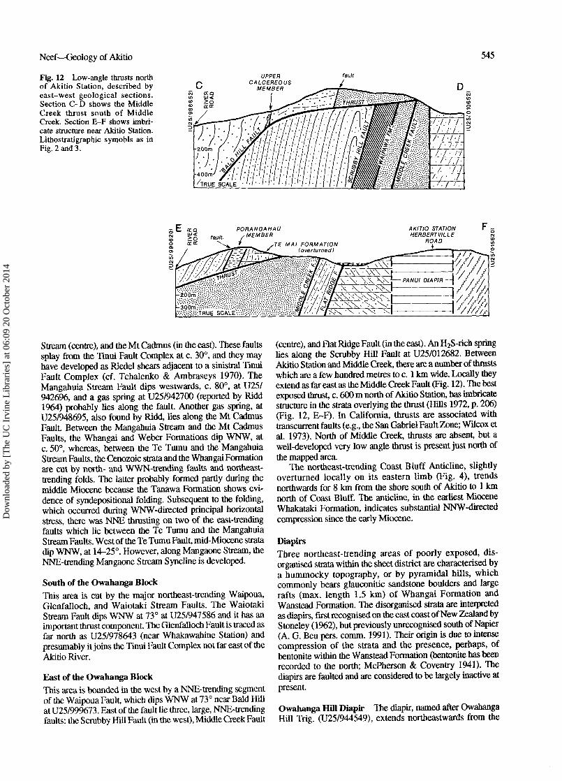
Fig. 12 Low-angle thrusts northof Akitio Station, described byeast-west geological sections.Section C-D shows the MiddleCreek thrust south of MiddleCreek. Section E-F shows imbri-cate structure near Akitio Station.Lithostratigraphic symobls as inFig. 2 and 3.
UPPERCALCEREOUS
MEMBER
fault
Stream (centre), and the Mt Cadmus (in the east). These faultssplay firom the Tinui Fault Complex at c. 30°, and they mayhave developed as Riedel shears adjacent to a sinistral TinuiFault Complex (cf. Tchalenko & Ambraseys 1970). TheMangahuia Stream Fault dips westwards, c. 80°, at U25/9426%, and a gas spring at U25/942700 (reported by Ridd1964) probably lies along the fault. Another gas spring, atU25/948695, also found by Ridd, lies along the Mt CadmusFault. Between the Mangahuia Stream and the Mt CadmusFaults, the Whangai and Weber Formations dip WNW, atc. 50°, whereas, between the Te Tumu and the MangahuiaStream Faults, the Cenozoic strata and the Whangai Formationare cut by north- and WWN-trending faults and northeast-trending folds. The latter probably formed partly during themiddle Miocene because the Tanawa Formation shows evi-dence of syndepositional folding. Subsequent to the folding,which occurred during WNW-directed principal horizontalstress, there was NNE thrusting on two of the east-trendingfaults which lie between the Te Tumu and the MangahuiaStream Faults. West of the Te Tumu Fault, mid-Miocene stratadip WNW, at 14-25°. However, along Mangaone Stream, theNNE-trending Mangaone Stream Syncline is developed.
South of the Owahanga BlockThis area is cut by the major northeast-trending Waipoua,Glenfalloch, and Waiotaki Stream Faults. The WaiotakiStream Fault dips WNW at 73° at U25/947586 and it has animportant thrust component. The Glenfalloch Fault is traced asfar north as U25/978643 (near Whakawahine Station) andpresumably it joins the Tinui Fault Complex not far east of theAkitio River.
East of the Owahanga BlockThis area is bounded in the west by a NNE-trending segmentof the Waipoua Fault, which dips WNW at 73° near Bald HillatU25/999673. East of the fault lie three, large, NNE-trendingfaults: the Scrubby Hill Fault (in the west), Middle Creek Fault
(centre), and Flat Ridge Fault (in the east). An H2S-rich springlies along the Scrubby Hill Fault at U25/012682. BetweenAkitio Station and Middle Creek, there are a number of thrustswhich are a few hundred metres to c. 1 km wide. Locally theyextend as far east as the Middle Creek Fault (Fig. 12). The bestexposed thrust, c. 600 m north of Akitio Station, has imbricatestructure in the strata overlying the thrust (Hills 1972, p. 206)(Fig. 12, E-F). In California, thrusts are associated withtranscurrent faults (e.g., the San Gabriel Fault Zone; Wilcox etal. 1973). North of Middle Creek, thrusts are absent, but awell-developed very low angle thrust is present just north ofthe mapped area.
The northeast-trending Coast Bluff Anticline, slightlyoverturned locally on its eastern limb (Fig. 4), trendsnorthwards for 8 km from the shore south of Akitio to 1 kmnorth of Coast Bluff. The anticline, in the earliest MioceneWhakataki Formation, indicates substantial NNW-directedcompression since the early Miocene.
DiapirsThree northeast-trending areas of poorly exposed, dis-organised strata within the sheet district are characterised bya hummocky topography, or by pyramidal hills, whichcommonly bears glauconitic sandstone boulders and largerafts (max. length 1.5 km) of Whangai Formation andWanstead Formation. The disorganised strata are interpretedas diapirs, first recognised on the east coast of New Zealand byStoneley (1962), but previously unrecognised south of Napier(A. G. Beu pers. comm. 1991). Their origin is due to intensecompression of the strata and the presence, perhaps, ofbentonite within the Wanstead Formation (bentonite has beenrecorded to the north; McPherson & Coventry 1941). Thediapirs are faulted and are considered to be largely inactive atpresent.
Owahanga Hill Diapir The diapir, named after OwahangaHill Trig. (U25/944549), extends northeastwards from the
Dow
nloa
ded
by [
The
UC
Irv
ine
Lib
rari
es]
at 0
6:09
20
Oct
ober
201
4
546 New Zealand Journal of Geology and Geophysics, 1992, Vol. 35
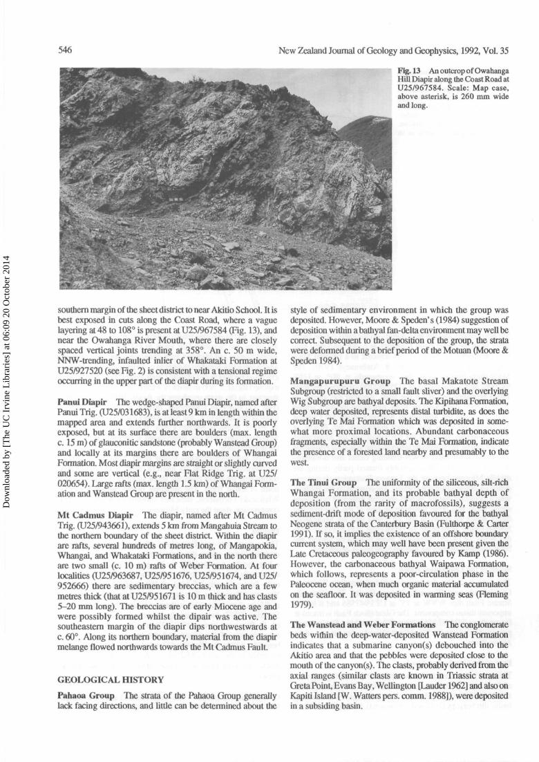
Fig. 13 An outcrop of OwahangaHill Diapir along the Coast Road atU25/967584. Scale: Map case,above asterisk, is 260 mm wideand long.
southern margin of the sheet district to near Akitio School. It isbest exposed in cuts along the Coast Road, where a vaguelayering at 48 to 108° is present at U25/967584 (Fig. 13), andnear the Owahanga River Mouth, where there are closelyspaced vertical joints trending at 358°. An c. 50 m wide,NNW-trending, infaulted inlier of Whakataki Formation atU25/927520 (see Fig. 2) is consistent with a tensional regimeoccurring in the upper part of the diapir during its formation.
Panui Diapir The wedge-shaped Panui Diapir, named afterPanui Trig. (U25/031683), is at least 9 km in length within themapped area and extends further northwards. It is poorlyexposed, but at its surface there are boulders (max. lengthc. 15 m) of glauconitic sandstone (probably Wanstead Group)and locally at its margins there are boulders of WhangaiFormation. Most diapir margins are straight or slightly curvedand some are vertical (e.g., near Flat Ridge Trig, at U25/020654). Large rafts (max. length 1.5 km) of Whangai Form-ation and Wanstead Group are present in the north.
Mt Cadmus Diapir The diapir, named after Mt CadmusTrig. (U25/943661), extends 5 km from Mangahuia Stream tothe northern boundary of the sheet district. Within the diapirare rafts, several hundreds of metres long, of Mangapokia,Whangai, and Whakataki Formations, and in the north thereare two small (c. 10 m) rafts of Weber Formation. At fourlocalities (U25/963687, U25/951676, U25/951674, and U25/952666) there are sedimentary breccias, which are a fewmetres thick (that at U25/951671 is 10 m thick and has clasts5-20 mm long). The breccias are of early Miocene age andwere possibly formed whilst the dipair was active. Thesoutheastern margin of the diapir dips northwestwards atc. 60°. Along its northern boundary, material from the diapirmelange flowed northwards towards the Mt Cadmus Fault.
GEOLOGICAL HISTORY
Pahaoa Group The strata of the Pahaoa Group generallylack facing directions, and little can be determined about the
style of sedimentary environment in which the group wasdeposited. However, Moore & Speden's (1984) suggestion ofdeposition within a bathyal fan-delta environment may well becorrect. Subsequent to the deposition of the group, the stratawere deformed during a brief period of the Motuan (Moore &Speden 1984).
Mangapurupuru Group The basal Makatote StreamSubgroup (restricted to a small fault sliver) and the overlyingWig Subgroup are bathyal deposits. The Kipihana Formation,deep water deposited, represents distal turbidite, as does theoverlying Te Mai Formation which was deposited in some-what more proximal locations. Abundant carbonaceousfragments, especially within the Te Mai Formation, indicatethe presence of a forested land nearby and presumably to thewest.
The Tinui Group The uniformity of the siliceous, silt-richWhangai Formation, and its probable bathyal depth ofdeposition (from the rarity of macrofossils), suggests asediment-drift mode of deposition favoured for the bathyalNeogene strata of the Canterbury Basin (Fulthorpe & Carter1991). If so, it implies the existence of an offshore boundarycurrent system, which may well have been present given theLate Cretaceous paleogeography favoured by Kamp (1986).However, the carbonaceous bathyal Waipawa Formation,which follows, represents a poor-circulation phase in thePaleocene ocean, when much organic material accumulatedon the seafloor. It was deposited in warming seas (Fleming1979).
The Wanstead and Weber Formations The conglomeratebeds within the deep-water-deposited Wanstead Formationindicates that a submarine canyon(s) debouched into theAkitio area and that the pebbles were deposited close to themouth of the canyon(s). The clasts, probably derived from theaxial ranges (similar clasts are known in Triassic strata atGreta Point, Evans Bay, Wellington [Lauder 1962] and also onKapiti Island [W. Watters pers. comm. 1988]), were depositedin a subsiding basin.
Dow
nloa
ded
by [
The
UC
Irv
ine
Lib
rari
es]
at 0
6:09
20
Oct
ober
201
4
Neef—Geology of Akitio 547
Inliers of Whangai strata along the Glenfalloch Faultsuggest a post-Cretaceous transtensional phase. The strike ofthe Mt Cadmus and Mangahuia Stream Faults is consistentwith a Reidel shear origin and left-lateral activity on the TinuiFault Complex. Absence of Wanstead Formation and verycondensed Weber Formation on the horst developed betweenthe Mt Cadmus and Mangahuia Stream Faults are consistentwith ?activity along these faults, and the adjacent Tinui FaultComplex, during the Eocene and Oligocene. Absence of theWeber Formation east of the Tinui Fault Complex indicatesthat this area was a subdued high, neither accreting norshedding sediment during the Oligocene. Such unconformitiesare well known offshore (Carter 1985).
The Whakataki Formation The formation was depositedfrom eastward-flowing turbidity currents. Abundant carbon-aceous fragments within the sandstone parts of the Boumasequences indicate a forested hinterland to the west. The ruditelenses east of Owahanga Hill, and south of the OwahangaRiver mouth, show that the Owahanga Hill Diapir wasgrowing in the earliest Miocene, and is probable evidence forthe initiation of the Kaikoura Orogeny at this time. Diapiractivity is common in lower slope environments above anactive subducting plate (Shiki & Misawa 1982) and is knownto occur along wrench faults (Barber & Brown 1988); it is dueto local overpressuring of connate water present within thebentonite-ricb Wanstead Formation.
Owahanga Group East of the Mt Cadmus Fault, turbiditeof Otaian age overlies the Mt Cadmus Diapir, indicating thatthe diapir was inactive after the earliest Miocene. TheSandstone Member of the Coast Road Formation, on thewestern margin of the sheet district, indicates a period ofshallowing followed by a deepening. This shallowing eventpossibly coincides with the worldwide unconformity atc. 22.5 Ma of Haq et al. (1987). Subsequently, in the lateAltonian, Clifdenian, and Lillburnian, the Tanawa Formationwas deposited from turbidity currents during a period ofdeformation (as is indicated by growth faults and slumpedstrata).
The NNE-trending thrusts, developed between theMangahuia Stream and the Mt Cadmus Faults, are interpretedto be due to dextral motion on the nearby Tinui Fault (cf.Sylvester 1988) at some time since the middle Miocene.
ACKNOWLEDGMENTS
I am grateful to Hugh Morgans, James Crampton, Ian Raine, BillWatters, and Graeme Wilson for foraminiferal, molluscan, micro-floral, petrological, and dinoflagellate identifications, respectively.Mike Katz is thanked for discussions on the structure of the areamapped. Edwin Kight (Akitio Station) and Toby Humphries(Wairakau Station) provided accommodation. Paul Vella, Alan Beu,Paul Lennox, and two anonymous referees are thanked for readingthe manuscript and making many valuable suggestions for theimprovement of the paper. Kay Jones typed the manuscript. MsKadar drew the figures.
REFERENCES
Arabasz, W. J.; Lowery, M. A. 1980: Microseismicity in theTararua-Wairarapa area: depth-varying stresses andshallow seismicity in the southern North Island, NewZealand. New Zealand journal of geology and geophysics23: 141-154.
Barber, T.; Brown, K. 1988: Mud diapirism: the origin of melangesin accretionary prisms? Geology today 4: 89-94.
Carter, R. M. 1985: The mid-Oligocene Marshall Paraconformity,New Zealand: Coincidence with global eustatic fall or rise?Journal of geology 93: 359-371.
Fischer, A. G.; Arthur, M. A. 1977: Secular variations in thepelagic realm. Society of Economic Paleontologists andMineralogists special publication 25: 19-50.
Fleming, C. A. 1979: The geological history of New Zealand and itslife. Auckland University Press. 141 p.
Fulthorpe, C. S.; Carter, R. M. 1991: Continental shelf progradationby sediment drift accretion. Bulletin of the GeologicalSociety of America 103: 300-309.
Goddard, E. N.; Trask, P. D.; De Ford, R. F.; Rove, O. N.;Signewald, J. T.; Overbeck, R. M. 1970: Rock colour chart.Boulder, Colorado. Geological Society of America.
Haq, B. U.; Hardenbol, J.; Vail, P. R. 1987: Chronology offluctuating sea levels since the Triassic. Science 235:1156-1167.
Hills, E. S. 1972: Elements of structural geology. 2nd ed. Chapmanand Hall. 502 p.
Hornibrook, N de B. 1959: Waipawa Black Shale (Siltstone). In:Fleming, C. A. ed. Lexique stratigraphique international 6:
s d u e 1 9 6 8 : A handbook of New Zealand microfossils(Foraminfera and Ostracoda). New Zealand Department ofScientific and Industrial Research information series 62:136 p.
Johnston, M. R. 1975: Sheet N159 and part of sheet N158—Tinui-Awatoitoi. Geological map of New Zealand 1:63 360.Wellington, New Zealand. Department of Scientific andIndustrial Research.
Kamp, P. J. 1986: Late Cretaceous-Cenozoic tectonic developmentof the Southwest Pacific region. Tectonophysics 121:225-251.
1987: Age and origin of the New Zealand orocline inrelation to the Alpine Fault movement. Journal of theGeological Society of London 144: 641-652.
Kennett, J. P. 1982: Marine geology. New Jersey, Prentice-Hall.813 p.
Kingma, J.T. 1967: Sheet 12—Welling ton. Geological map of NewZealand 1:250 000. Wellington, New Zealand. Departmentof Scientific and Industrial Research.
Korsch, R. J.; Roser, B. P. 1986: Variations in grain size, petrologyand geochemistry within single beds from a Miocene trench-slope basin. Abstracts. Twelfth International Sedimento-logical Congress, Canberra. P. 168.
Lauder, W. R. 1962: Notes on the greywackes near WellingtonCity. New Zealand journal of geology and geophysics 5:626-629.
McPherson, E. D.; Coventry, R. G. 1941: Bentonite in southernHawkes Bay. New Zealand journal of science andtechnology B 22: 265B-279B.
Moore, P. R. 1988: Stratigraphy, composition and environment ofdeposition of the Whangai Formation and associated LateCretaceous-Paleocene rocks, eastern North Island, NewZealand. New Zealand Geological Survey bulletin 100: 82 p.
Moore, P. R.; Speden, I. G. 1979: Stratigraphy, structure, andinferred environments of deposition of the Early Cretaceoussequence, eastern Wairarapa, New Zealand. New Zealandjournal of geology and geophysics 22: 417-433.
1984: The Early Cretaceous (Albian) sequence of easternWairarapa, New Zealand. New Zealand Geological Surveybulletin 97: 98 p.
Dow
nloa
ded
by [
The
UC
Irv
ine
Lib
rari
es]
at 0
6:09
20
Oct
ober
201
4
548 New Zealand Journal of Geology and Geophysics, 1992, Vol. 35
Moore, P. R.; Adams, A. G.; Isaac, M. J.; Mazengarb, C ; Morgans,H. E. G.; Phillips, C. J. 1986: A revised Cretaceous-earlyTertiary stratigraphic nomenclature for eastern North Island,New Zealand. New Zealand Geological Survey reportG104: 31 p.
Morgan, P. G. 1910: Report on probable occurrence of petroleumand other minerals in eastern Wairarapa district. Appendix tothe journals of the House of Representatives N.Z. C-16: 6.
Neef, G. 1967: The geology of Eketahuna. Unpublished Ph.D.thesis, lodged in the Library, Victoria University ofWellington.
1991: Field guide to pre-conference trip: geology of thePongaroa-Akitio districts, 23rd and 24th November 1991.Geological Society of New Zealand miscellaneouspublication 59B: 1-15.
--------1992: Turbidite deposition in five Miocene, bathyalformations along an active plate margin, North Island, NewZealand: with notes on styles of deposition at the margins ofeast coast bathyal basins. Sedimentary geology 78:111-136.
Neef, G.; Plimer, I. R.; Bottrill, R. S. 1985: Submarine-fan depositedsandstone and rudite in a mid-Cenozoic interarc basin,Maewo, Vanuatu (New Hebrides). Sedimentology 32:519-542.
O'Byrne, T. N. 1963: The geology of Pongaroa, Akitio County. Acorrelation of erosion and soils with lithology. UnpublishedM.Sc. thesis, lodged in the Library, Victoria University ofWellington.
Ongley, M. 1935: Eketahuna Subdivision. New Zealand GeologicalSurvey 29th annual report (n.s.) 1934-1935: 1-6.
1936: Dannevirke Subdivision. New Zealand GeologicalSurvey 30th annual report (n.s.): 1-4.
Ongley, M.; Williamson, J. H. 1931: Eketahuna Subdivision. NewZealand Geological Survey 25th annual report (n.s.): 3-5.
Park, J. 1888: On the probable discovery of oil and coal in WairarapaNorth County. New Zealand Geological Survey report ofgeological explorations 1887-88 19: 20-24.
Pickering, K.; Hiscott, R. N.; Hein, F. J. 1989: Deep-marineenvironments: sedimentation and tectonics. London, UnwinHyman. 416 p.
Quennell, A. M.; Brown, D. A. 1937: Dannevirke Subdivision. NewZealand Geological Survey 31st annual report (n.s.): 1-6.
Ridd, M. F. 1964: The geology of the northern Wairarpara, NorthIsland, New Zealand. Unpublished New Zealand GeologicalSurvey open-file petroleum report 329.
Shiki, T; Misawa, Y. 1982: Fore arc geological structure of theJapanese Islands. In: Legget, J. K. ed. Trench-forearcgeology: Sedimentation and tectonics of modern and ancientactive plate margins. Geological Society of London specialpublication 10: 63-73.
Speden, I. G. 1977: Taitai Series (Early Cretaceous) and theelimination of the Mokoiwian Stage. New Zealand journalof geology and geophysics 20: 537-562.
Sporli, K. B. 1980: New Zealand and oblique-slip margins: tectonicdevelopment up to and during the Cenozoic. In: Ballance,P. F.; Reading, H. G. ed. Sedimentation in oblique slipmobile zones. International Association of Sedimentologistsspecial publication 4: 147-170.
Stevens, G. R.; Suggate, R. P. 1978: Atlas of paleogeographic maps.In: Suggate, R. P. ed. The geology of New Zealand. Vol. H.Wellington, Government Printer. Pp. 727-745.
Stoneley, R. 1962: Marl diapirism near Gisborne, New Zealand.New Zealand journal of geology and geophysics 5:630-641.
Sylvester, A. G. 1988: Strike-slip faults. Geological Society ofAmerica bulletin 100: 1666-1703.
Tchalenko, J. S.; Ambraseys, N. N. 1970: Structural analysis of theDasht-e Bayaz (Iran) earthquake fractures. GeologicalSociety of America bulletin 81: 41-60.
Vella, P. 1963: Upper Pleistocene succession in the inland part ofWairarapa valley, New Zealand. Transactions of the RoyalSociety of New Zealand geology 2: 63-75.
Vella, P.; Kaewyana, W.; Vucetich, C. G. 1988: Late Quaternaryterraces and their cover beds, north-western Wairarapa, NewZealand, and their provisional correlations with oxygenisotope stages. Journal of the Royal Society of New Zealand18: 309-324.
Walcott, R. I. 1987: Geodetic strain and the deformational history ofthe North Island of New Zealand during the late Cenozoic.Philosophical transactions of the Royal Society of London.A321: 163-181.
Wellman, H. W. 1959: Divisions of the New Zealand Cretaceous.Transactions of the Royal Society of New Zealand 87:99-163.
Wilcox, R. E.; Harding, T. P.; Seely, D. R. 1973: Basic wrenchtectonics. American Association of Petroleum Geologistsbulletin 57: 74-96.D
ownl
oade
d by
[T
he U
C I
rvin
e L
ibra
ries
] at
06:
09 2
0 O
ctob
er 2
014