geology and petrology of the mont royal pluton, montrealfaculty.uml.edu/nelson_eby/field trip...
TRANSCRIPT

GEOLOGY AND PETROLOGY OF THE MONT ROYAL PLUTON, MONTREAL
NELSON EBY Environmental, Earth and Atmospheric Sciences, University of Massachusetts, Lowell, MA 01854
Sunday, September 13, 2015
Geology of the Northeastern Adirondack Mountains and Champlain–St. Lawrence Lowlands of New York, Vermont and Québec
New York State Geological Association, 87th Annual Meeting State University of New York at Plattsburgh,
Plattsburgh, NY 12–13 September 2015

1
GEOLOGY AND PETROLOGY OF THE MONT ROYAL PLUTON, MONTREAL
NELSON EBY Environmental, Earth and Atmospheric Sciences, University of Massachusetts, Lowell, MA 01854
INTRODUCTION
The Cretaceous Monteregian Hills (MH) petrographic province consists of a group of small alkaline plutons, and associated dikes, extending along a linear trend from approximately 30 km west of Montreal, Canada, to approximately 60 km east of Montreal (Fig. 1). Mont Megantic, located approximately 150 km east of Montreal has been included in the MH province (because of its geographic location), but geologically Mont Megantic belongs to the Younger White Mountain petrographic province of New Hampshire, Maine and Vermont. The MH plutons are largely composed of silica-undersaturated alkaline rocks: carbonatite and other strongly silica-undersaturated lithologies occur at Oka, and nepheline normative gabbros and pyroxenites, nepheline-bearing diorites, and feldspathoidal-bearing syenites and monzonites occur at the other MH plutons. Slightly silica-
saturated quartz-bearing syenites are found at Monts Brome and Shefford. Philpotts (1974) and Eby (1987) have summarized the geology and petrology of the MH province.
The White Mountain (WM) petrographic province (Fig. 1) consists of two groups of plutons (Eby, 1987), one group (Older WM) intruded during the Jurassic and the other (Younger WM) during the Cretaceous. In contrast with the MH province, all the Younger WM plutons, with the exception of Cuttingsville, are silica-saturated to silica-over-saturated and the dominant lithologies are gabbro, diorite, syenite, quartz syenite, and granite. Rhyolite and basalt are found at Ossipee, a classic ring complex. Of note is that the silica-under-saturated lithologies occur to the west of Logan’s Line (which represents the boundary between the Precambrian Grenville terrane and the folded Appalachians) while only silica-saturated lithologies are found to the east. The older WM plutons are dominantly composed of syenite, quartz syenite, and granite. Mafic rocks are generally sparse and are only abundant in the Pliny Range and Belknap Mountain complex (both contain diorite and monzodiorite). Silica-under-saturated rocks, nepheline syenite, occur at Red Hill and Rattlesnake Mountain, ME. Geology and Petrology of the MH Plutons
The location and shape of the various plutons are shown in Figure 2. With the exception of Oka, which consists of two ring-like structures, the plutons are relatively small and more or less circular in shape. Because the plutons are more resistant to erosion than the surrounding sedimentary rocks they form
Figure 1. Location and geological setting of the Monteregian Hills and White Mountain igenous provinces (modified from Lentz et al., 2006).

2
prominent topographic features in the St. Lawrence Lowlands. On a clear day most of the MH plutons can be seen from the Chalet du Mont-Royal in the Parc du Mont-Royal. This park encompasses much of the top of Mont Royal and is also of interest because it was designed by the well-known landscape architect, Frederick Law Olmsted (who also designed the Emerald Necklace in Boston and Central Park in New York City).
The Oka carbonatite complex occurs at the western end of the MH province. It consists of a carbonatite core and a number of strongly-silica-undersaturated lithologies (okaite, melteigite, ijolite, and urtite). Alnoitic rocks are confined to the Oka area. Field oriented descriptions of the Oka complex can be found in Gold et al. (1986) and Lentz et al. (2006).
Monts Royal, Bruno, Rougemont, and Yamaska largely consist of mafic silica-undersaturated lithologies. The common rock types are pyroxenite and gabbro. These largely cumulate sequences frequently show primary igneous foliation. Nepheline is rarely found in the mafic rocks and the silica-undersaturated character is essentially due to the presence of abundant kaersutite (a Ti-rich amphibole). At Monts Royal and Yamaska, nepheline-bearing gabbros, diorites, monzonites, and syenites intrude the earlier mafic sequences. For further details see Eby (1984, Royal and Bruno) and Eby (1989, Yamaska).
Figure 2. Terrain map (center) showing the location of the Monteregian Hills plutons. Top and bottom images show the terrain for each of the plutons. Because the rocks of the plutons are more resistant to erosion (except at Oka) the individual plutons occur as hills within the St. Lawrence Lowlands. Images are from Google Maps.

3
Mont St. Gregoire (formerly known as Mount Johnson) consists of a fine-grained nepheline diorite (essexite) core surrounded by coarser-grained nepheline diorite and nepheline syenite. Various petrogenetic models have been proposed for this pluton, including silicate-silicate liquid immiscibilty (Eby, 1984).
Mont St. Hilaire has been a mecca for mineral collectors for decades. Over 300 minerals, of which at least 30 are new species, have been identified, most from the Poudrette quarry (because of a change in ownership it is now called the Carrière Mont Saint-Hilaire and no mineral collecting is allowed). The eastern half of the pluton consists of nepheline-sodalite syenite while the western half consists of two mafic sequences comprised of pyroxenite, gabbro, nepheline-bearing gabbro and diorite, and monzonite (Currie et al., 1986).
The eastern most plutons, Monts Bome and Shefford, largely consist of gabbros, diroites and a variety of felsic rocks. With the exception of late-stage nepheline-bearing diorites and syenites, the rocks are silica-saturated to slightly silica over-saturated (Eby, 1985a).
Mafic and felsic dikes are widely distributed throughout the MH province and intrude both the plutons and the country rock. The dikes tend to lie along a NW-SE trend. The mafic dikes are classified as lamprophyre (alnoite, monchiquite, camptonite), alkali olivine basalt, and basanite. The felsic dykes are classified as bostonite, solvsbergite, nepheline syenite, and tinguaite. The strongly-silica-under-saturated dikes are concentrated towards the western end of the province. Further details can be found in Bedard et al. (1988) and Eby (1985b), among others. Geochronology, Geochemistry, and Petrogenesis of the MH Plutons 39Ar/40Ar dating of biotite and amphibole (Foland et al., 1986, 1989; Gilbert and Foland, 1986) indicates that the intrusions had a short emplacement history centered around 124 Ma. Heaman and LeCheminant (2001), using U-Pb dating of perovskite and apatite, determined an emplacement age of 140 Ma for the Île Bizard breccia pipe. The apatite fission-track age for Île Bizard is 121 Ma (reported in Lentz et al., 2006). For the Oka carbonatite complex, fission-track apatite ages range from 116 to 130 Ma (reported in Lentz et al., 2006). U-Pb apatite ages for Oka range from 107 to 132 Ma with two age clusters - 113 to 117 Ma and 125 to 127 Ma (Chen and Simonetti, 2013). These age data indicate an extended period of magmatic activity (~113 to 140 Ma) at the western end of the MH province, which is in marked contrast to the very restricted range of ages determined for the other MH plutons using 39Ar/40Ar dating of biotite and amphibole.
For the younger WM intrusions K-Ar ages vary from 108 to 125 Ma (Foland and Faul, 1977). High precision 39Ar/40Ar ages have been determined for Green Mountain (120 Ma) and Merrymeeting (121 Ma) (Foland and Allen, 1991). A Rb-Sr isochron age of 122 has been determined for Ascutney (Foland et al., 1985) and Eby (unpublished data) has obtained SHRIMP U-Pb zircon ages of 122 Ma for Ossipee. Thus the high precision geochronology indicates emplacement of the younger WM plutons in a very narrow age range at 122 Ma. These ages are within error identical to those determined for most of the MH plutons. The one exception is Cuttingsville, for which the mean age (based on K-Ar and fission-track titanite dating) is 100 ± 2 Ma (Eby and McHone, 1997). Taken in total, the existing geochronology of the MH and younger WM does not support a hot-spot trace. The spatial distribution (Fig. 1) of the plutons, however, does suggest that they may represent a failed aulacogen (note the approximately 120o angle between the MH and younger WM plutons).
The rocks of the Monteregian Hills, with the exception of some cumulates, plot in the alkali field on a total alkalis versus silica diagram. Most of the rocks are nepheline normative, although the nepheline

4
normative character of the cumulate rocks is due to the presence of abundant amphibole, rather than the occurrence of nepheline. In the strongly silica-under-saturated sequences there is a well-developed trend of alkali enrichment with increasing silica and this is reflected in the increase in modal nepheline. Rare earth (REE) abundance patterns show moderate to strong enrichment in the LREE with respect to the HREE, with the strongly silica-under-saturated rocks showing the greatest enrichment. Sr, Nd, and Pb isotopic studies by Eby (1985c), Grunenfelder et al. (1985), Wen et al. (1987), and Chen et al. (1994) have led to the conclusion that the source of the MH magmas was a depleted subcontinental lithosphere. During their ascent and emplacement, the magmas interacted to various degrees with the surrounding country rock which could be of Grenville or Lower Paleozoic age. Coupled with the trace element data it was suggested (Eby, 1987) that the subcontinental mantle was metasomatized shortly before or during melting. Recent studies of N, Ar, and Pb isotopic co-variations (Roulleau et al., 2012) and Nd-Sr-Hf-Pb isotopes (Roulleau and Stevenson, 2013) support this model. The authors of the recent studies also concluded that the subcontinental lithospheric mantle was metasomatized by a convecting asthenspheric plume.
In summary, the chemical and isotopic data indicate that the MH magmas were derived from a depleted mantle source (similar to the source that gives rise to ocean island basalts). This source was metasomatized shortly before or during melting. The source was most likely a garnet lherzolite mantle, although in some cases a spinel lherzolite mantle provides a better fit to the data. During ascent the magmas interacted to various degrees with the crust and AFC models involving relatively minor contamination can reproduce the observed chemical trends.
MONT ROYAL Geological Setting
Mont Royal is elliptical in shape and has a surface area of approximately 4 km2 (Fig. 3). At the present level of erosion, the intrusion is in contact with Ordovician shales (Utica formation) and limestones (Trenton formation) that have been metamorphosed to the pyroxene hornfels facies. The bulk of the intrusion consists of a heterogeneous gabbro-pyroxenite body. A plagioclase-rich leucocratic gabbro can be mapped as a separate unit. The gabbro-pyroxenite body is intruded by a nepheline-bearing diorite and widely distributed leucrocratic dikes which include feldspathoidal monzonites, feldspathoidal syenites, and quartz-bearing syenites. The felspathoidal monzonites are cut by both the feldspathoidal syenite and the quartz-bearing syenites, but cross-cutting relationships have not been observed between the latter two lithologies. Mafic dikes were intruded at the same time.
Figure 3. Geologic map of Mont Royal. Modified from Woussen (1969).

5
Petrography
Medium- to coarse-grained gabbro – pyroxenite: In the field changes in lithology are gradational over a few millimeters to centimeters and largely reflect changes in the modal abundances of the constituent minerals (Table 1). The more mafic members (Fig. 4) show a number of features typical of cumulate rocks including adcumulus overgrowths and intercumulus crystals. The more plagioclase-rich gabbros (Fig. 5) do not generally show cumulate textures, but some do show flow banding. The major minerals are titanaugite, kaersutite, opaque minerals (ilmenite and magnetite), occasional olivine, biotite, and plagioclase. The pink titanaugites are often rimmed by green aegirine-augite, and in most samples the pyroxenes have been slightly to extensively altered to red-brown kaersutite. Kaersutite also occurs as separate grains apparently of primary origin, and is locally abundant. Olivine occurs both as isolated grains and within pyroxene. The opaque mineral associated with kaersutite is generally ilmenite, while the rest of the opaque mineral suite is dominated by magnetite. In the more mafic rocks the plagioclase occurs as an intercumulus phase, and it is moderately to strongly zoned. Apatite is an important accessory, ranging from 0.5 to 2%. Feldspathoidal minerals were not observed in any of the specimens.
Leucogabbro: This unit is characterized by a greater abundance of plagioclase and a lesser abundance of amphibole and pyroxene (Table 1) which gives rise to its lighter color (Fig. 6). Olivine occurs in some samples. Red-brown biotite, apatite, opaque minerals, and titanite are accessories. Feldspathoids are absent.
Nepheline-bearing diorite: This unit (Fig. 7) is similar in appearance to the leucogabbro but it is distinguished from the leucogabbro by the presence of nepheline and orthoclase (Table 1). Kaersutite is more abundant than titanaugite and both minerals are often rimmed by green Na-rich amphiboles. Accessory minerals are biotite, apatite and opaque minerals. Flow banding is commonly observed.
Mafic dikes: The mafic and leucocratic dikes were emplaced simultaneously. The mafic dikes are very fine-grained to fine-grained. The major minerals are amphibole (hastingsite and/or kaersutite), calcic plagioclase, and augite (Fig. 8). Biotite occurs as an accessory mineral. Some varieties consist solely of calcic plagioclase and kaersutite and have been described as camptonite (Woussen, 1969). In some of the samples fine-grained calcic plagioclase - kaersutite enclaves are found in a somewhat coarser-grained matrix composed of pyroxene, amphibole, and plagioclase, which suggests multiple phases of intrusion.
Leucocratic dikes: The feldspathoidal monzonites (Fig. 9) consist of variable amounts of plagioclase, alkali feldspar (often perthitic), kaersutite zoned to hastingsite, titanaugite rimmed with pale green pyroxene (usually subordinate to kaersutite), sodalite, and nepheline. The opaque minerals (mostly magnetite) occur as accessories, and a few samples contain accessory red-brown garnet. Titanite, apatite, and zircon occur in trace amounts. The felspathoidal syenites (Fig. 10) consist essentially of perthitic alkali feldspar, up to 10% nepheline, minor plagioclase, aegirine-augite, hastingsite, and trace titanite, opaque minerals, and zircon. The quartz-bearing syenites (Fig. 11) largely consist of perthitic alkali feldspar and plagioclase. The mafic minerals are light green pyroxene and kaersutite, rimmed with hastingsite. Quartz occurs interstitially and constitutes less than 2% of the rock. Magnetite occurs as an accessory and there are trace amounts of apatite.

6
Figure 4a. RY 8 -Pyroxenite (PL) Figure 4b. RY8 - Pyroxenite (XP)
Figure 5a. RY11 - Gabbro (PL) Figure 5b. RY11 - Gabbro (XP)
Figure 6a. RY22 - Leucogabbro (PL) Figure 6b. RY22 - Leucogabbro (XP)

7
Figure 7a. RY3 - Nepheline-bearing diorite (PL) Figure 7b. RY3 - Nepheline-bearing diorite (XP)
Figure 8a. RY33 - Mafic dike (PL) Figure 8b. RY33 - Mafic dike (XP)
Table 1. Mont Royal – modes for mafic igneous rocks Lithology Sample Ol Cpx Amp Pl Kfs Nph Bi Ap Opq Other
Pyroxenite RY8 - 45.2 36.5 9.6 - - 2.4 1.1 3.4 1.8 RY10 - 39.3 42.2 3.9 - - 0.9 1.0 10.7 2.0 RY16 - 32.5 46.3 4.2 - - 0.2 - 16.3 0.4 Gabbro RY1 - 35.3 23.6 27.1 - - 5.7 0.3 5.8 2.2 RY11 0.9 34.1 12.0 38.7 - - 6.2 0.1 7.9 0.1 RY23 - 40.4 17.2 27.1 - - 4.2 0.2 10.5 0.4 RY29 - 36.0 8.6 31.6 - - 14.5 1.5 5.5 2.4 Leucogabbro RY12 - 24.5 4.1 54.1 - - 7.7 0.9 8.7 - RY22 11.1 29.6 4.0 44.1 - - 5.0 0.5 4.8 0.9 RY34 0.4 7.4 6.9 79.4 - - 1.3 0.1 4.1 0.3 Nph diorite RY3 - 1.1 17.4 60.1 8.8 3.6 5.0 1.9 8.8 -
RY5 - 11.0 19.2 32.9 11.4 12.9 1.7 3.0 7.9 -

8
Figure 9a. RY9 – Feldspathoidal monzonites (PL)
Figure 9b. RY9 – Feldspathoidal monzonites (XP)
Figure 10a. RY28 – Feldspathoidal syenite (PL) Figure 10b. RY28 - Feldspathoidal syenite (XP)
Figure 11a. RY20 – Quartz syenite (PL) Figure 11b. RY20 - Quartz syenite (XP)

9
Mineral Chemistry
At Mont Royal the major rock-forming minerals are clinopyroxene, amphibole, and plagioclase. Biotite is locally abundant. Olivine is found in some gabbro and leucogabbro specimens. The olivines show a restricted range of compositions (Fig. 12) centered around Fo70. The clinopyroxenes in the mafic rocks are augite while aegirine-augite occurs in the more felsic rocks and in the pyroxenites and gabbros as rims on augite (Fig. 12). The plagioclases vary from labradorite and bytownite in the mafic rocks to oligoclase in the felsic rocks. K-feldspar occurs in some of the felsic rocks (Fig. 12). The biotites are Mg-rich with the exception of biotites from the nepheline-bearing diorite which are Fe-rich (Fig. 12).
Because of the complexity of the amphibole group, the currently accepted classification scheme (Leake et al., 1997) is based on amphibole chemistry. According to this classification scheme the Mont Royal amphiboles are predominantly kaersutite and hastingsite (Fig. 13). Kaersutite is the common amphibole in the pyroxenites, gabbros, and nepheline-bearing diorites and hastingsite is the common amphibole in the feldspathoidal monzonites and syenites. Geochemistry
With the exception of the quartz-bearing syenites, all the Mont Royal rocks are nepheline-normative and alkaline (Fig. 14). A well-defined trend (which falls on the Tholeiitic – Calc-Alkaline boundary) towards alkali enrichment is shown in an AFM diagram. The exception is some of the gabbro and pyroxenite samples that plot to the right of the trend, a reflection of their cumulate character. On a TAS diagram (Fig. 14) the Mont Royal rocks plot
Figure 12. Range of chemical compositions for olivine, pyroxene, biotite and plagioclase.
Figure 13. Classification of Mont Royal amphiboles.

10
in both silica-under-saturated and silica-saturated fields. The very low silica samples are cumulates.
REE and primitive-mantle-normalized elemental plots (Fig. 15) and Sr and Pb isotope plots (Fig. 16) are found on the next page. Based on time and interest we will talk about the significance of the data during the field trip. Geochronology 39Ar/40Ar biotite and amphibole ages for the MH plutons cluster around 124 Ma (Foland et al., 1986, 1989; Gilbert and Foland, 1986). However, none of these studies determined a radiometric age for Mont Royal. Apatite (population method) and titanite (external detector method) fission-track ages have been determined for Mont Royal. A description of the analytical protocol used in our laboratory can be found in Eby et al. (1995). Apatite and titanite ages are statistically indistinguishable and yield a mean age of 122 Ma. This is a slightly younger age than that determined for the other MH plutons using 39Ar/40Ar dating. Of interest are the blocking (or annealing) temperatures for the various systems: ~350oC
Figure 14. Summary diagrams for Mont Royal whole-rock geochemistry.

11
for 39Ar/40Ar biotite, ~250oC for titanite, and ~60oC for complete track retention in apatite. From these data one can infer that the rocks cooled from magmatic to ambient temperatures in several million years which leads to the conclusion that the depth of emplacement was very shallow, no more than ~1 km.
Figure 15. Chondrite normalized REE plots and primitive mantle normalized elemental plots for the various Mont Royal lithologies.
Figure 16. Sr and Pb isotope diagrams for the various Mont Royal lithologies and comparisons with potential mantle sources.
Table 2. Titanite and apatite fission-track ages Number Spontaneous Induced Dosimeter Mean Age Sample Lithology crystals Rs (Ns) Ri (Ni) Rd (Nd) Age (Ma) (Ma)
Titanite Ages RY5 Neph Diorite 7 6.79 114 5.36 90 5.96 1811 118.5 ± 45.5 121.4 ± 3.3 RY12 Leucogabbro 15 26.6 959 15.4 554 4.67 2879 126.5 ± 22.1
RY17 Mafic dike 8 3.23 62 2.29 44 5.37 1635 118.8 ± 10.3 RY29 Gabbro 4 2.15 206 1.66 159 5.92 1811 120.3 ± 35.4 RY33 Mafic dike 4 5.94 57 4.06 39 5.35 1635 122.8 ± 53.8
Apatite Ages RY10 Pyroxenite 60/60 3.01 433 3.9 561 5.27 1635 126.3 ± 3.1 122.0 ± 3.7 RY12 Leucogabbro 50/50 9.4 1130 13.8 1654 5.85 1811 123.7 ± 2.9
RY16 Pyroxenite 60/60 4.1 590 5.66 815 5.27 1635 118.6 ± 2.9 RY23 Gabbro 60/60 3.65 525 4.99 719 5.25 1635 119.3 ± 2.9

12
FIELD GUIDE AND ROAD LOG
Meeting Point: Southeastern parking lot of Hudson Hall on the SUNY Plattsburgh campus. The lot is
located at the corner of Beekman and Broad streets.
Meeting Point Coordinates: 44.696oN, 73.467oW
Departure Time: 7:30 AM
Distance in miles (km)
Cumu- Point to Route Description lative Point
0.0 (0.0) 0.0 (0.0) Starting in the parking lot for Hudson Hall, SUNY Plattsburgh, corner of Beekman and Broad St., Plattsburgh, NY. Turn left out of parking lot (north) on Beekman St. toward Cornelia St.
0.7 (1.1) 0.7 (1.1) Turn right onto Boynton Ave.
1.2 (1.9) 0.5 (0.8) Turn left onto NY-22 N
1.4 (2.2) 0.2 (0.3) Take the Interstate 87 N ramp.
1.9 (3.0) 0.5 (0.8) Merge onto I-87 N.
21.6 (34.7) 19.7 (31.7) Take Exit 42 to Champlain and continue right at end of exit ramp. Merge onto Rt. 11 E.
23.7 (38.1) 2.1 (3.4) Take a left at the traffic light on Rt.276 N to Lacolle, QC border crossing.
26.0 (41.8) 2.3 (3.7) Quebec border crossing – Passport or Enhanced License Needed! Continue north on Quebec Rt. 221.
29.7 (47.8) 3.7 (6.0) Left on Quebec Rt. 202 W to Autoroute 15 N to Montreal.
33.4 (53.8) 3.7 (6.0) Turn right onto onramp for Autoroute 15 N to Montreal.
62.6 (100.8) ~29.2 (47.0) Take exit 53 to Pont Champlain. Merge onto Boulevard Marie Victorin/Autoroute 15 N toward Montreal/Quebec/Autoroute 20 /Autoroute 10/Sherbrooke.
63.1 (101.6) 0.5 (0.8) Take the Autoroute 10/Autoroute 15 N/Autoroute 20/Pont Champlain ramp to the Pont Champlain (Champlain Bridge) to Montreal across the St. Lawrence River.
63.7 (102.6) 0.6 (1.0) Merge onto Autoroute 10/Autoroute 15 N/Autoroute 20.Continue to follow Autoroute 15 N/Autoroute 20.
67.8 (109.2) 4.1 (6.6) Take Av Atwater Ave. exit toward Rue Saint-Patrick St.
68.0 (109.5) 0.2 (0.3) Merge onto Atwater Ave.
68.4 (110.1) 0.4 (0.6) Turn left to stay on Atwater Ave.
69.7 (112.2) 1.3 (2.1) Turn right onto Dr. Penfield Ave.
69.8 (112.3) 0.09 (0.1) Turn left onto Côte-des-Neiges Rd.
69.8 (112.3) 0.04 (0.06) Keep left to stay on Côte-des-Neiges Rd.
70.3 (113.6) 0.8 (1.3) Turn right onto Chemin Remembrance.
13
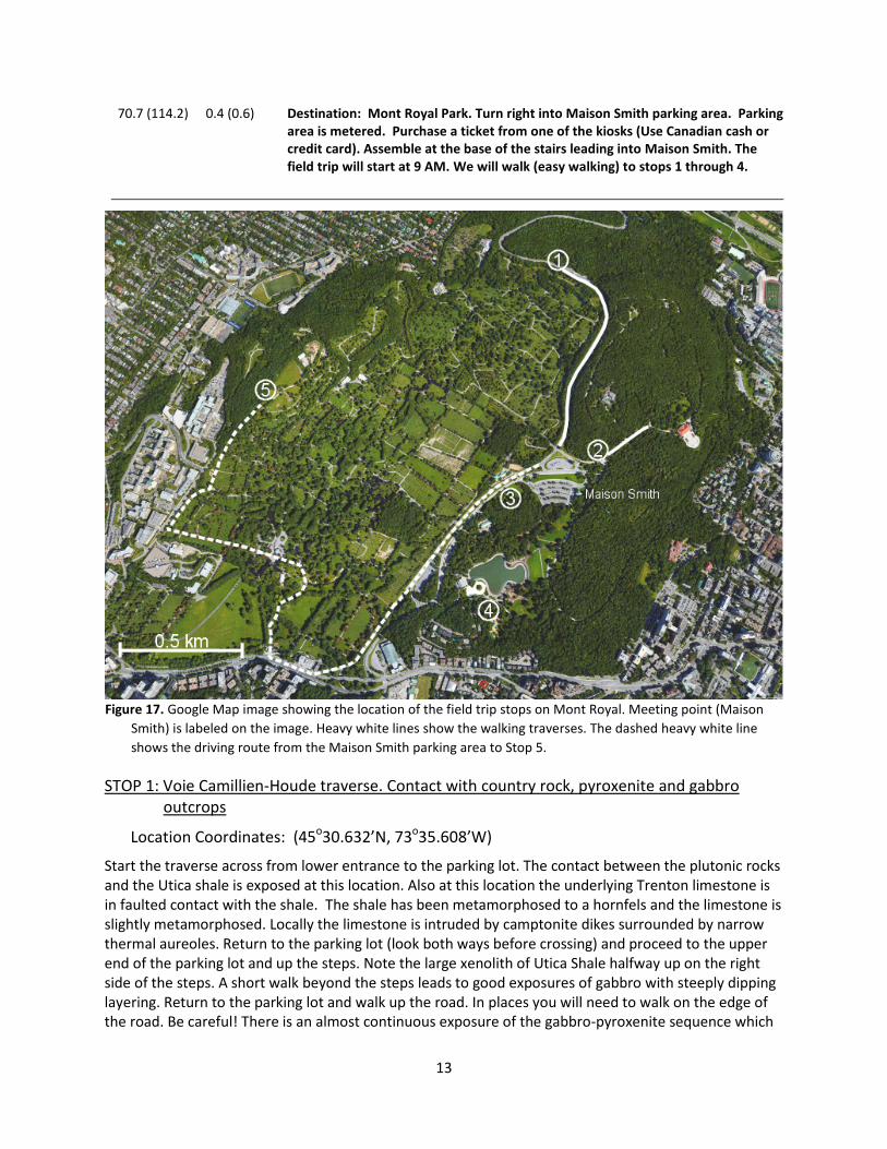
70.7 (114.2) 0.4 (0.6) Destination: Mont Royal Park. Turn right into Maison Smith parking area. Parking area is metered. Purchase a ticket from one of the kiosks (Use Canadian cash or credit card). Assemble at the base of the stairs leading into Maison Smith. The field trip will start at 9 AM. We will walk (easy walking) to stops 1 through 4.
STOP 1: Voie Camillien-Houde traverse. Contact with country rock, pyroxenite and gabbro
outcrops
Location Coordinates: (45o30.632’N, 73o35.608’W)
Start the traverse across from lower entrance to the parking lot. The contact between the plutonic rocks and the Utica shale is exposed at this location. Also at this location the underlying Trenton limestone is in faulted contact with the shale. The shale has been metamorphosed to a hornfels and the limestone is slightly metamorphosed. Locally the limestone is intruded by camptonite dikes surrounded by narrow thermal aureoles. Return to the parking lot (look both ways before crossing) and proceed to the upper end of the parking lot and up the steps. Note the large xenolith of Utica Shale halfway up on the right side of the steps. A short walk beyond the steps leads to good exposures of gabbro with steeply dipping layering. Return to the parking lot and walk up the road. In places you will need to walk on the edge of the road. Be careful! There is an almost continuous exposure of the gabbro-pyroxenite sequence which
Figure 17. Google Map image showing the location of the field trip stops on Mont Royal. Meeting point (Maison Smith) is labeled on the image. Heavy white lines show the walking traverses. The dashed heavy white line shows the driving route from the Maison Smith parking area to Stop 5.

14
is cut by multiple felsic dikes. At the end of the traverse, opposite the entrance to the Cimetière Mont-Royal, part of the limestone screen is exposed. The intensely deformed metamorphosed limestone consists of a mixture of calcite marble and a greenish skarn of eipidote, tremolite, zoisite, and diopside.
STOP 2: Belvedere traverse. Pyroxenite and gabbro cut by various mafic and felsic dikes
Location Coordinates: (45o30.167’N, 73o35.500’W)
This traverse is along the road leading to the Belvedere. The pyroxenites and gabbro are intruded by a variety of mafic and felsic dikes. The feldspathoidal monzonite and feldspathoidal syenite dikes are light gray in color, medium-grained, and vary in width from a few millimeters to a few tenths of a meter. The lithologies are distinguished on the basis of the alkali feldspar/plagioclase ratio, a distinction which is not apparent at the outcrop scale. Late stage medium- to coarse-grained quartz-bearing syenites, which weather to a distinctive salmon pink color, cut the feldspathoidal monzonites and feldspathoidal syenites. This traverse ends at the Belvedere. On a clear day there is a superb view of the Monteregian Hills plutons from this location.
STOP 3: Gabbro and pyroxenite
Location Coordinates: (45o30.065’N, 73o35.788’W)
Large outcrops of gabbro in wooded area across from RCMP station.
STOP 4: Foliated leucogabbro
Location Coordinates: (45o29.846’N, 73o35.870’W)
Foliated leucogabbro. Foliation is essentially vertical and the outcrop is cut by a felsic dike. The leucogabbro is distinguished on the basis of a lighter color index due to a greater amount of feldspar. Olivine is found in some specimens. Amphibole is much less abundant relative to the more mafic units.
Distance in miles (km)
Cumu- Point to Route Description lative Point
70.7 (114.2) 0.0 (0.0) Return to the vehicles. Exit parking area and turn left onto Chemin Remembrance. Our next stop is in the Notre-Dame-des-Neiges Cemetery. The entrance from Chemin Remembrance (which is closest to the outcrops) is closed on Saturday and Sunday. This road log will take you in the main entrance off Chemin de la Côte-des-Neiges.
71.5 (115.4) 0.8 (1.2) Bear right onto Chemin de la Côte-des-Neiges.
71.6 (115.6) 0.1 (0.2) Turn right into Notre-Dame-des-Neiges Cemetery.
71.8 (115.9) 0.2 (0.3) Bear left and after a short distance (<0.05 mi) bear left onto east-west road that passes cemetery office buildings on the right.
72.1 (116.4) 0.3 (0.5) Proceed to edge of cemetery and turn right. Continue on road that runs along the cemetery boundary.
72.5 (117.1) 0.4 (0.7) Destination. Park by side of road.

15
STOP 5: Nepheline-bearing diorite
Location Coordinates: (45o30.318’N, 73o36.567’W)
Nepheline-bearing diorite outcrops are found in the woods next to the grave site. The outcrops extend outside of the cemetery and at the time this field trip guide was written could be accessed through a break in the fence. Sample RY3 and RY5 (Table 1) were collected from this location. RY3 (Fig. 7) is medium-grained and shows a subparallel alignment of plagioclase which is interpreted as a flow texture. RY5 is similar, but coarser-grained.
Distance (miles)
Cumu- Point to Route Description lative Point
72.5 (117.1) 0.0 (0.0) Reverse direction and return to cemetery entrance.
73.4 (118.6) 0.9 (1.5) Turn right onto Chemin de la Côte-des-Neiges.
73.7 (118.9) 0.3 (0.5) Bear right onto Avenue Decelles.
74.3 (119.9) 0.6 (1.0) Turn right onto Chemin de la Côte-Sainte-Catherine.
76.2 (122.9) 1.9 (3.0) Turn left onto Boulevard Saint Joseph.
76.8 (125.4) 1.6 (2.5) Turn right onto Avenue Papineau.
79.2 (129.3) 2.4 (3.9) Proceed to Île Ste. Hélène via Pont Jacques Cartier. Turn right off bridge onto Île Ste. Hélène. This exit has a very short slip ramp. Pay close attention to tailgaters and give plenty of warning.
79.3 (129.4) 0.1 (0.15) At bottom of ramp bear to the left. From this point on bear or turn left (see Fig. 18).
79.5 (129.7) 0.2 (0.3) Turn left into parking lot. This is the location for Stop 6 and also marks the end of the field trip. To return to Plattsburgh continue east (away from Montreal) on the Pont Jacques Cartier. Turn right (south) onto 132 which eventually becomes 15. Continue to Canada/USA border. On the USA side of the border 15 becomes I-87. Continue on I-87 to Plattsburgh.
STOP 6: Île Ste. Hélène diatreme breccia
Location Coordinates: (45o31.199’N, 73o32.118’W)
The large hill on Île Ste. Hélène is composed of diatreme polymictic breccia (Figs. 19, 20). Many of the buildings (Fig. 21) on the island were built using the breccia and provide some of the best exposures (not to be sampled). The field trip stop is an abandoned quarry which was the source for some of the building material.
A large variety of clasts can be found in the breccia. These include fossiliferous shale and limestone clasts which contain Devonian brachiopods. The youngest exposed sediments in the St. Lawrence Lowland are lower Silurian in age and thus these clasts represent some of the missing overlying sedimentary column. Other clasts include Trenton limestone, Utica shale, and metamorphic basement clasts. The breccias exposed on Île Ste. Hélène do not contain an igneous matrix. However, the comminuted material does have an elevated Ti content and the presence of analcime, perovskite, and apatite suggest there is an igneous component. Hydrothermal activity subsequent to emplacement resulted in veins carrying calcite, analcime, apatite, and rare Ti-minerals.

16
Figure 18. Location of Stop 6, an abandoned quarry that is now a parking area. Dashed line shows driving route. Image is from Google Maps.
Figure 20. Google Earth image of Île Ste. Hélène.
Figure 19. Geological map of the distribution of breccia and Utica shale on Île Ste. Hélène (From Lentz et al., 2006).
Figure 21. Tour Lévis, which occupies the summit of the higher hill, was constructed using the diatreme breccia.

17
REFERENCES CITED Bedard, J. H. J., Francis, D. M., and Ludden, J., 1988, Petrology and pyroxene chemistry of Monteregian dykes: the
origin of concentric zoning and green cores in clinopyroxenes from alkali basalts and lamprophyres, Canadian Journal of Earth Sciences, v. 25, p. 2041-2058.
Chen, J., Henderson, C. M. B., and Foland, K. A., 1984, Open-system, sub-volcanic magmatic evolution: constraints on the petrogenesis of the Mount Brome alkaline complex, Canada, Journal of Petrology, v. 35, p. 1127-1153.
Chen, W., and Simonetti, A., 2013, In-situ determination of major and trace elements in calcite and apatite, and U-Pb ages of apatite from the Oka carbonatite complex: insights into a complex crystallization history, Chemical Geology, v. 353, p. 151-172.
Currie, K. L., Eby, G. N., and Gittins, J., 1986, The petrology of the Mont Saint Hilaire pluton, southern Quebec: an alkaline gabbro – peralkaline syenite association, Lithos, v. 19, p. 65-81.
Eby, G. N., 1984, Monteregian Hills I. Petrography, major and trace element geochemistry, and strontium isotopic chemistry of the western intrusions: Mounts Royal, St. Bruno, and Johnson, Journal of Petrology, v. 235, p. 421-452.
Eby, G. N., 1985a, Monteregian Hills II. Petrography, major and trace element geochemistry, and strontium isotopic chemistry of the eastern intrusions: Mounts Shefford, Brome, and Megantic, Journal of Petrology, v. 26, p. 418-448.
Eby, G. N., 1985b, Age relations, chemistry, and petrogenesis of mafic alkaline dikes from the Monteregian Hills and younger White Mountain igneous provinces, Canadian Journal of Earth Sciences, v. 22, p. 1103-1111.
Eby, G. N., 1985c, Sr and Pb isotopes, U and Th chemistry of the alkaline Monteregian and White Mountain provinces, eastern North America, Geochimica et Cosmochimica Acta, v. 49, p. 1143-1154.
Eby, G. N., 1987, The Monteregian Hills and White Mountain alkaline igneous provinces, eastern North America, in Fitton, J. G., and Upton, B. G. J. (Eds.), Geological Society Special Publication No. 30. London, Geological Society, p. 433-447.
Eby, G. N., 1989, Petrology and geochemistry of Mount Yamaska, Quebec, Canada: a mafic representative of the Monteregian Hills petrographic province, in Leelanandam, C. (Ed.), Alkaline Rocks, Geological Society of India Memoir 15. Bangalore, India, B. B. D. Power Press, p. 63-82.
Eby, G. N., Roden-Tice, M., Krueger, H. L., Ewing, W., Faxon, E. H., and Woolley, A. R., 1995, Geochronology and cooling history of the northern part of the Chilwa alkaline province, Malawi, Journal of African Earth Sciences, v. 20, p. 275-288.
Eby, G. N., and McHone, J. G., 1997, Plutonic and hypabyssal intrusions of the Early Cretaceous Cuttingsville Complex, Vermont, in Grover, T.W., Mango, H. N., and Hasenohr, E. J. (Eds.), Guidebook to Field Trips in Vermont and Adjacent New Hampshire and New York, New England Intercollegiate Geological Conference, Castleton, VT, p. B2-1-B2-17.
Foland, K. A., and Faul, H., 1977, Age of the White Mountain intrusives – New Hampshire, Vermont, and Maine, USA, American Journal of Science, v. 277, p. 888-904.
Foland, K. A., Henderson, C. M. B., and Gleason, J., 1985, Petrogenesis of the magmatic complex at Mount Ascutney, Vermont, USA, Contributions to Mineralogy and Petrology, v. 90, p. 331-345.
Foland, K. A., Gilbert, L. A., Sebring, C. A., and Jiang-Feng, C., 1986, Ar-40/Ar-39 ages for plutons of the Monteregian Hills, Quebec: evidence for a single episode of Cretaceous magmatism, Geological Society of America Bulletin, v. 97, p. 966–974.

18
Foland, K. A., Chen, J.-F., Linder, J. S., Henderson, C. M. B., and Williams, I. M., 1989, High resolution 40Ar/39Ar chronology of multiple intrusion igneous complexes: application to the Cretaceous Mount Brome complex, Quebec, Canada, Contributions to Mineralogy and Petrology, v. 102, p. 127–137.
Foland, K. A., and Allen, J. C., 1991, Magma sources for Mesozoic anorogenic granites of the White Mountain magma series, New England, USA, Contributions to Mineralogy and Petrology, v. 109, p. 195-211.
Gold, D. P., Eby, G. N., Bell, K., and Vallee, M., 1986, Carbonatites, diatremes, and ultra-alkaline rocks in the Oka are, Quebec: Geological Association of Canada, Mineralogical Association of Canada, Canadian Geophysical Union, Joint Annual Meeting, Ottawa ’86, Field Trip 21 Guidebook, 51 p.
Grunenfelder, M. H., Tilton, G. R., Bell, K., and Blenkinsop, J., 1985, Lead and strontium isotope relationships in the Oka carbonatite complex, Geochimica et Cosmochimica Acta, v. 50, p. 461-468.
Heaman, L. M., and LeCheminant, A. N., 2001, Anomalous U-Pb systematics in mantle-derived baddeleyite from Île Bizard: evidence of high temperature radon diffusion?, Chemical Geology, v. 172, p. 77-93.
Leake, B. E., Woolley, A. R., Arps, C. E. S., and a cast of thousands, 1997, Nomenclature of amphiboles: report of the subcommittee on amphiboles of the International Mineralogical Association Commission on New Minerals and Minerals Names, Canadian Mineralogist, v. 35, p. 219-246.
Lentz, D., Eby, N. Lavoie, S., and Park, A., 2006, Diatremes, dykes, and diapirs: revisiting the ultra-alkaline to carbonatitic magmatism of the Monteregian Hills: GAC/MAC Joint Annual Meeting, Montreal, Quebec, Field Trip B4, 48 p.
Philpotts, A. R., 1974. The Monteregian Province, in Sorenson, H. (Ed.), The Alkaline Rocks. New York, John Wiley, p. 293-310.
Roulleau, E., Pinti, D. L., Stevenson, R. K., Takahata, N., Sano, Y., and Pitre, F., 2012, N, Ar and Pb isotopic co-variations in magmatic minerals: discriminating fractionation processes from magmatic sources in Monteregian Hills, Québec, Canada, Chemical Geology, v. 326-327, p. 123-131.
Roulleau, E., and Stevenson, R., 2013, Geochemical and isotopic (Nd-Sr-Hf-Pb) evidence for a lithospheric mantle source in the formation of the alkaline Monteregian Province (Quebec), Canadian Journal of Earth Sciences, v. 50, p. 650-666.
Wen, J., Bell, K., and Blenkinsop, J., 1987, Nd and Sr isotope systematics of the Oka complex, Quebec, and their bearing on the evolution of the sub-continental upper mantle, Contributions to Mineralogy and Petrology, v. 97, p. 433-437.
Woussen, G., 1969, Notes on the geology of Mont Royal, in Pouliot, G. (Ed.), Guidebook for the Geology of Monteregian Hills, The Geological Association of Canda/The Mineralogical Association of Canada, Montreal, Canada, p. 63-73.