geological evolution of the norwegian continental shelf ... · 251 geological evolution of the...
TRANSCRIPT
251
Geological evolution of the Norwegian continental shelf between 61ºN and 68ºN during the last 3 million years
Dag Ottesen, Leif Rise, Espen Sletten Andersen, Tom Bugge & Tor Eidvin
Ottesen, D., Rise, L., Andersen, E.S., Bugge, T. & Eidvin, T.: Geological evolution of the Norwegian continental shelf between 61ºN and 68ºN during the last 3 million years. Norwegian Journal of Geology Vol. 89, pp. 251-265. Trondheim 2009, ISSN 029-196x.
The Late Pliocene-Pleistocene Naust Formation and equivalent sediments have been mapped on the Norwegian continental shelf between Sogne-fjorden and Lofoten (61°N to 68°N). During the last 2.8 million years the shelf has prograded up to 150 km westwards. More than 1000 m of sedi-ments have been deposited in large areas around the outer shelf/upper continental slope. Most of the Naust Formation on the mid-outer shelf com-prises prograding wedges, commonly thinning westwards and downlapping onto the top of the underlying Kai Formation. 3D seismic data from the shelf show iceberg ploughmarks on palaeo-surfaces buried below 400 m of sediment at the present-day shelf edge. Tentatively, the oldest observed ice-grooved surface is c. 2 million years old. In several hydrocarbon exploration wells, abundant angular gravel fragments, interpreted as ice-rafted debris (IRD), have been found in the lower parts of the Naust Formation. In addition to these observations, the very high depositional rates compa-red to the previous Tertiary period, support our view that most of the Naust Formation was deposited under glacial influence.The Naust Formation is subdivided into five sequences. From oldest to youngest these are named N, A, U, S and T. Naust S represents the third last glaciation, whereas Naust T is from the last and second last glaciation. An upper regional angular unconformity (URU), best developed on the inner-mid part of the shelf, marks the boundary upwards to more flat-lying sedimentary units. These units mainly comprise tills, deposited during the last extensive glaciations on the shelf. The upper regional unconformity is over large areas off mid-Norway at the base of sequence Naust T and represents an erosional surface made by the Elsterian Ice Sheet.
Dag Ottesen, Geological Survey of Norway, NO-7491 Trondheim, Norway, ([email protected]), Leif Rise, Geological Survey of Norway, NO-7491 Trondheim, Norway, ([email protected]), Espen Sletten Andersen, Statoil ASA, NO-0246 Oslo, ([email protected]), Tom Bugge, Det norske oljeselskap ASA, Nedre Bakklandet 58c, NO-7014 Trondheim, Norway,([email protected]), Tor Eidvin, Norwegian Petroleum Directorate, P.O. Box 600, NO-4003 Stavanger, Norway ([email protected]). Dag Ottesen, present address: Exploro AS, Stiklestadveien 1, 7040 Trondheim
IntroductionThe mid-Norwegian shelf has been an area of extensive oil and gas exploration during the last 25 years (Fig. 1). 2D and 3D seismic data, detailed bathymetry, geotechnical borings and exploration wells have generated much data on the shallow geology. During the last 15 years, exploration has also focused on prospects in deeper water (>500 m) on the continental slope and in the deep sea. The joint industrial Seabed Project was initiated in 1995 as one of several projects in the Norwegian Deepwater Programme (NDP), with the aim of acquiring knowledge of importance for deep-water licences. Several projects focusing on the shallow stratigraphy have been carried out, the main areas of interest being from the shelf edge and into deeper water. Stability assessment studies for the outer shelf/upper continental slope areas have constituted an important part of the work (McNeill et al. 1998, Bryn et al. 2005, Solheim et al. 2005).
The Storegga megaslide (Bugge 1983, Bugge et al. 1988) occurred c. 8000 years ago and affected a very large slope area with a runout several hundred kilometres into the deep sea. Some 3000 km3 of slide debris were mobilised, generating a tsunami that hit most of the Norwegian coast, Shetland, the Faeroes and Scotland (Bondevik
et al. 1997). The giant Ormen Lange gas field is located below the Storegga Slide Scar at c. 1000 m water depth (Fig. 1), and extensive scientific studies were carried out in order to investigate if a safe development of the gas field was possible (Solheim et al. 2005). One of these studies was mapping of the Late Pliocene-Pleistocene stratigraphy of the shelf and slope between the outlet of the Norwegian Channel (62ºN) and Lofoten (68ºN) (Rise et al. 2002, 2005). Later, this study was extended in the joint industrial Seabed Project (with Fugro, the British Geological Survey, the Geological Survey of Norway and 10 oil companies) increasing the seismic data base from the Ormen Lange Project (c. 25,000 km) to about 100,000 km (NDP 2004). The area was also enlarged southwards to include shelf areas north of Sognefjorden (61°N) (Fig. 1).
This paper summarises the development of the Norwegian continental shelf between 61ºN and 68ºN during the last 3 million years on the basis of the results from the last phase of the Seabed Project (Bugge et al. 2004, NDP 2004). The extended seismic data base has notably improved our understanding of the development of the margin, especially in the southern parts of the study area, compared to Rise et al. (2005). We now use a revised Naust stratigraphic nomenclature where the Naust Formation has been subdivided into five
NORWEGIAN JOURNAL OF GEOLOGY Geological evolution of the Norwegian continental shelf
252 D. Ottesen et al. NORWEGIAN JOURNAL OF GEOLOGY
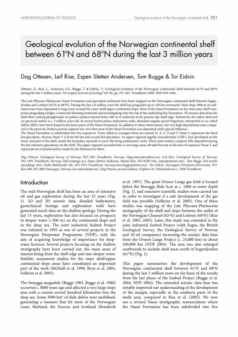
Fig. 1. Bathymetric map of the study area between Sognefjorden (S) and Lofoten (L). Red polygons – 3D-seismic survey areas. Blue outline – subcrop of Molo Formation. Blue stippled lines – subcrop of sediments equivalent to the Molo Formation. Thick black lines – seismic profiles (Figs. 2 and 3). Dotted black line – present shelf edge. NC - Norwegian Channel, NSF – North Sea Fan, ST – Stad, SKS – Sklinnadjupet Slide, SS – Storegga Slide, HHA – Helland-Hansen Arch (dotted white line marks the shallowest part of the dome), SK-Skjoldryggen, HB-Haltenbanken, TB-Trænabanken, VB-Vøring Basin, TS-Trænadjupet Slide, Tr-Trondheim, T-Tampen, TAS-The buried Tampen Slide.
253
sequences, named from oldest to youngest N, A, U, S and T (Bugge et al. 2004, NDP 2004, Rise et al. 2006). The sedimentary regime under which the huge volumes of sediments in the Naust Formation were deposited, and especially its lower parts, have been debated for a long time (Rokoengen et al. 1988, Henriksen & Vorren 1996, Rise et al. 2005). On the basis of 3D-seismic cubes we have studied geomorphic features on buried seismic surfaces, providing information about the processes involved in deposition and erosion of the Naust Formation. Only a few high-quality cores from the older
parts of the Naust Formation exist. These have been investigated in this study, mainly to look for indications of glacial influence during deposition.
Dalland et al. (1988) established the Naust Formation on the mid-Norwegian continental shelf as a Late Pliocene-Pleistocene section. The corresponding sediments in the North Sea Basin (outside western Norway, in the southern part of the study area) belong to the Nordland Group (Isaksen & Tonstad 1989), but have not been named as a specific formation. To include the sediments
NORWEGIAN JOURNAL OF GEOLOGY Geological evolution of the Norwegian continental shelf
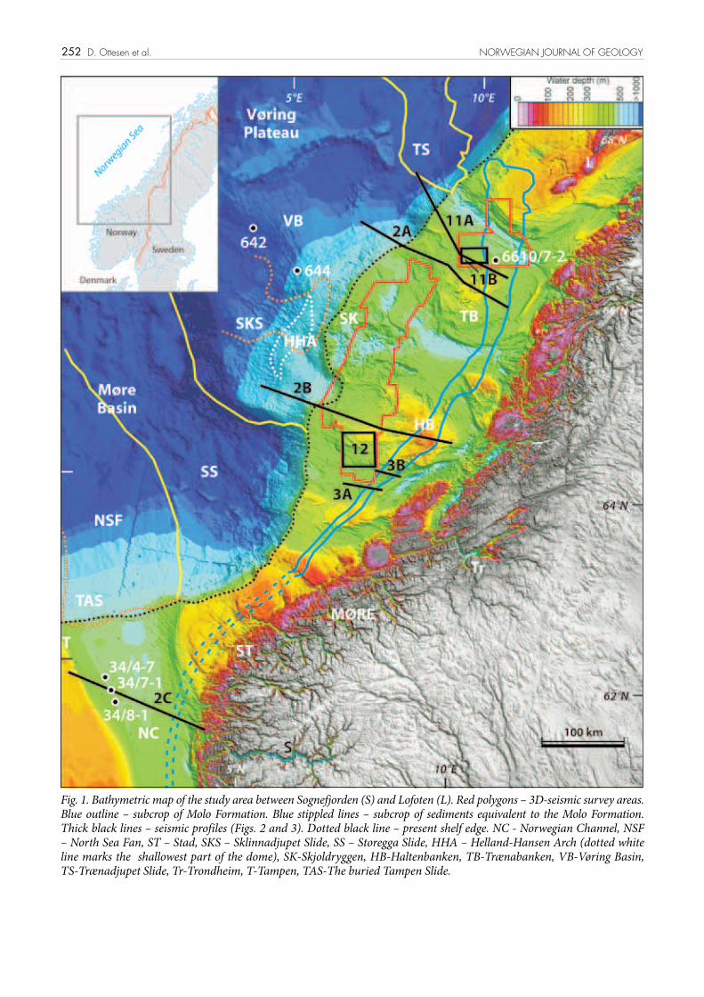
Fig. 2. Seismic profiles GMNR-94-106 (A), GMNR-94-310 (B) and NVGTI-92-105 (C). See Fig. 1 for locations. Yellow line in Fig. 2C marks the location of well 34/7-1 and the depth where the side-wall cores shown in Fig. 9 are taken (yellow arrow). N, A, U, S and T mark the different Naust sequences. HHA – Helland-Hansen Arch. M – Molo Formation.
254
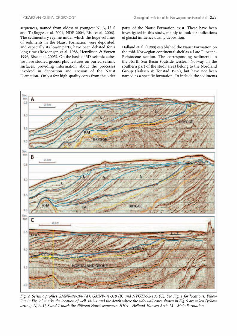
Fig. 3. (A) Seismic profile MB84-04 showing the transition between the Molo and Naust forma-tions. See Fig. 1 for loca-tion. (B) High-resolution seismic line across the Molo Formation, located in Fig. 1.
for the whole study area, we refer to them as ‘the Naust Formation and Naust equivalents’.
Geological backgroundThe present-day morphology of the mid-Norwegian continental shelf is mainly the product of rapid outbuilding (progradation) of the shelf during the last 3 million years (Rise et al. 2005). The continental shelf is less than 100 km wide off Møre in the south (62°N to 63°N), widens up to 250 km at 66°N, before narrowing to the north again. Off the Lofoten islands, the shelf is only 60-80 km wide. The mid-Norwegian continental shelf is characterised by shallow banks separated by cross-shelf troughs (Fig. 1). The banks have water depths between 50 m and 300 m, whereas the troughs have water depths between 150 m and 550 m. These troughs have been the former pathways for fast-flowing ice streams during several glaciations (Ottesen et al. 2005, Rise et al. 2005, Dowdeswell et al. 2006). The largest pathway for an ice stream is the Norwegian Channel, which is an 800 km long ice-generated trough parallel to the coastline off southern Norway, starting in the Skagerrak between Denmark and Norway and ending outside western Norway at 62ºN. The trough is about 100 km wide west
of Norway, and is a major geomorphological feature of the North Sea (Longva & Thorsnes 1997, Sejrup et al. 2003, Ottesen et al. 2005). The Norwegian Channel has been excavated by ice streams during several glaciations. Based on dating of sediments near the base of the channel, Sejrup et al. (1995) suggested the age of the Norwegian Channel to be at least 1.1 million years. The Norwegian Channel ice streams transported glacial debris to the mouth of the trough, and up to 1500 m of sediments occur in the trough mouth fan (the North Sea Fan). The sediments mainly comprise glacigenic debris-flow successions interbedded with units of slide deposits (King et al. 1996, Nygård et al. 2005).
The bedrock of the Norwegian shelf comprises sediment-ary units ranging in age from Triassic to Pliocene (Rokoengen et al. 1988, Sigmond 1992, 2002). The boundary between sedimentary and crystalline rocks is located 10-40 km west of the outer islands along the coast (Fig. 1). Due to basinward subsidence and extensive erosion of the inner part of the shelf, together with land uplift of the inner shelf and adjacent land areas, the units subcrop more or less parallel to the coast and decrease in age westwards (Bugge et al. 1984, Rokoengen et al. 1988). The coast-parallel, deltaic, Molo Formation was deposited from the coast off Møre (63º15’N) to the Lofoten Islands
D. Ottesen et al. NORWEGIAN JOURNAL OF GEOLOGY
255NORWEGIAN JOURNAL OF GEOLOGY Geological evolution of the Norwegian continental shelf
(67º50’N), over a distance of c. 500 km (Henriksen et al. 2005) (Fig. 1). This formation has recently been re-dated as Late Miocene to Early Pliocene, and is interpreted as the shallow-water equivalent to the Kai Formation (Eidvin et al. 2007). The Molo Formation is dominantly sandy and was deposited by coastal progradation as a result of regional onshore uplift (Rokoengen et al. 1995, Henriksen & Weimer 1996, Eidvin et al. 2007). The Molo Formation has a characteristic seismic reflection pattern with densely spaced clinoforms which dip westwards at up to 10º (Fig. 3B). The bathymetry reveals varying resistance to erosion of the Mesozoic and Tertiary bedrock units. Sandy units, for example, commonly show a positive relief, in contrast to areas with fine-grained sediments which are generally located in depressions. The Naust Formation is underlain by the Brygge (55-16 My) and Kai (16-4 My) Formations (Dalland et al. 1988, NDP 2004). These formations are moderately deep to deep-marine deposits, and in the Møre and Vøring basins they are composed mainly of claystones or oozes deposited by hemipelagic or contouritic processes.
The Møre and Vøring basins have been major sedi-mentary depocentres (Blystad et al. 1995), and in some areas the pre-existing topography has been important for the present overall shape of the margin. For instance, the deep Møre Basin (63°N to 64°N) outside Møre (Fig. 1) has prevented a substantial shelf progradation, and in this area the shelf is very narrow. East of the relatively shallow Vøring Plateau (water depths between 1200 m to 1400 m), an extensive progradation has occurred into a basin of intermediate depths (Fig. 2B).
A series of compressional domes or arches of mainly Mid Cenozoic age has been important for determining the depositional pattern of the margin (Japsen & Chalmers 2000, Lundin & Dore 2002).
In the inner part of the shelf, the Mesozoic and Cenozoic sediments have been cut by erosion. The regional seismic lines show that the middle and outer parts of the mid-Norwegian continental shelf have subsided, whereas the inner shelf and the Norwegian mainland have been uplifted (Fig. 2). This means that much of the eroded sediment is preserved on the middle/outer shelf, and little on the inner shelf. Riis (1996) estimated a ‘late’ uplift to be c. 1000 m in southern Norway and about the same in northern Norway, the uplift centre being in the Lofoten area and farther north. The timing of the Neogene uplift phase is uncertain, and the Norwegian mountain range may already have been uplifted substantially before the first ice sheets covering Scandinavia reached the coastal areas about 2.8 million years ago (Jansen & Sjøholm 1991).
The depositional pattern of the last three glaciations has been mapped on the outer shelf by Rise et al. (2005). This has revealed the very dynamic nature of the ice sheets with changing depocentres from glaciation to glaciation. Shifts in the position of fast-flowing ice streams appear to
be the most important factor for changes in the location of sediment delivery to the shelf edge and upper slope (Dowdeswell et al. 2006).
The last major shaping of the shelf topography occurred during the Late Weichselian glaciation, and several types of morainic ridges and glacial lineations demonstrate the dynamic nature of the Scandinavian palaeo-ice sheet (Ottesen et al. 2005). Apart from places where major slides occurred, the topography has remained nearly unchanged since the ice sheet retreated to the coastal areas c. 13,000 years ago. After deglaciation, the Norwegian fjord systems acted as major sedimentary traps (Aarseth 1997). Only up to a few tens of metres of sediment associated with deglaciation, and Holocene sediments have been deposited in the deepest troughs on the shelf. At intermediate and shallow water depths non-deposition and winnowing of sediments by bottom currents have prevailed since the ice sheet retreated.
Seismic data and interpretationThe reflection seismic database consists of conventional 2D, high-resolution 2D, and exploration 3D seismic. The exploration 2D seismic lines have a relative low vertical resolution, but are well suited for studying the regional development of the Naust Formation. A few multi-channel, high-resolution 2D seismic lines of very good quality exist on the outer shelf and slope. The high-resolution analogue sparker data commonly recorded to 0.5 second two-way travel time (twt) cover the entire study area with a regular N-S, E-W grid with a line spacing of 10 x 25 km (Rise 1988). Interpretation was carried out on a work station for both 2D and 3D seismic surveys, applying the Seisvision software. The interpreted horizons (xyz-data) were exported, gridded and visualised in Geosoft. The volume of the different Naust sequences was computed as the difference between each of the surfaces. For time-depth conversion of the surfaces, a sound velocity of 2000 m/s was used.
The 3D-seismic data, which cover large parts of the outer shelf (Fig. 1), have a line spacing of 12.5 m or 25 m and a vertical resolution making it possible to detect small morphological features such as iceberg ploughmarks and glacial lineations a few metres deep. The largest 3D cube compiled by Statoil consists of several merged 3D surveys covering large parts of the outer shelf (Fig. 1). In addition, three 3D seismic surveys (ST9404, ST9604 and NLGS-95) have been utilised from northern Trænabanken and Trænadjupet covering an area of c. 3200 km2 (Fig. 1).
The Naust FormationThe Naust Formation comprises the Late Pliocene-Pleistocene sediments on the Norwegian shelf, forming
256
a thick succession of prograding wedges and flat-lying sheet-like units, mainly of glacial origin (King et al. 1987, 1991, Rokoengen et al. 1995, Henriksen & Vorren, 1996, Eidvin et al. 1998, Dahlgren et al. 2005, Rise et al. 2005). At the beginning of this period, a huge increase in the supply of sediment occurred on the mid-Norwegian continental shelf. This was probably caused by the onset of glaciations in Scandinavia which, together with land uplift, led to major erosion. The Naust Formation is bounded by the coast-parallel deltaic Molo Formation in the east (Figs. 2 and 3). Base Naust is commonly recognised as a pronounced down-lap surface marking the boundary with the underlying Kai Formation.
Parts of the Naust Formation have been mapped in several subareas of the mid-Norwegian continental shelf
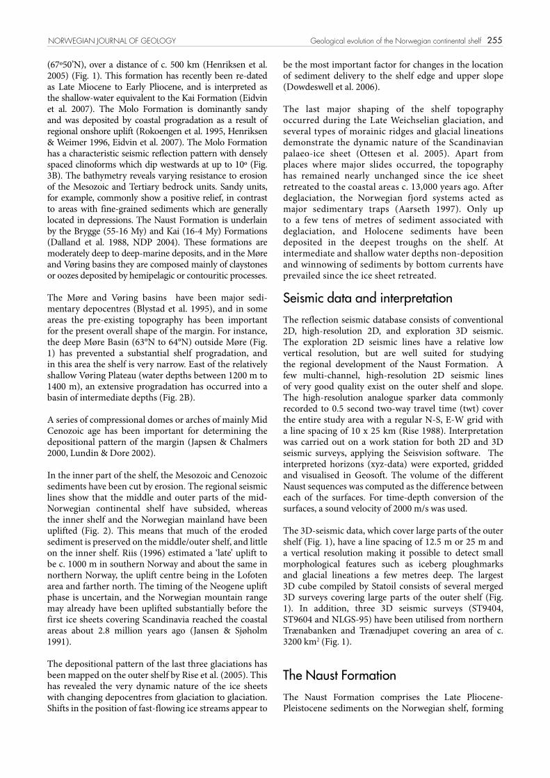
(Rokoengen et al. 1995, Henriksen & Vorren, 1996, King et al. 1996, Dahlgren et al. 2002, 2005, Hjelstuen et al. 2004) using a different stratigraphic nomenclature north and south of the Storegga Slide. Due to a complex and variable geology over the whole study area, a unified stratigraphy has been difficult to compile. An attempt to tie data across the slide area was made by McNeill et al. (1998). The shelf is narrow east of the central part of the Storegga Slide Scar, and some of the stratigraphy is missing in the area due to several huge slides within the Naust Formation which coalesce into the main slide scar (NDP 2004). Based on stratigraphic mapping in the Ormen Lange Project (Rise et al. 2002, 2005, Berg et al. 2005), a unified stratigraphy and nomenclature between 62ºN and 67ºN was proposed (Fig. 4).
Jansen & Sjøholm (1991) and Fronval & Jansen (1996) reported the onset of major glaciations in northern Europe at around 2.8 million years ago on the basis of the IRD (Ice-Rafted Debris) record from ODP boreholes 642, 643 and 644 located on the Vøring margin west of a major depocentre of the Naust Formation (Fig. 1). Eidvin et al. (2000) correlated the start of the deposition of the Naust Formation with this large increase in the supply of ice-rafted material.
The age of the different Naust Sequences is poorly constrained. This is due to the fact that very little cored material has been sampled from the petroleum wells (mainly cuttings), few index fossils occur and fossil faunas are sometimes extensively reworked. The proposed ages for the sequences must therefore be regarded as provisional, especially for the three oldest; N, A and U.
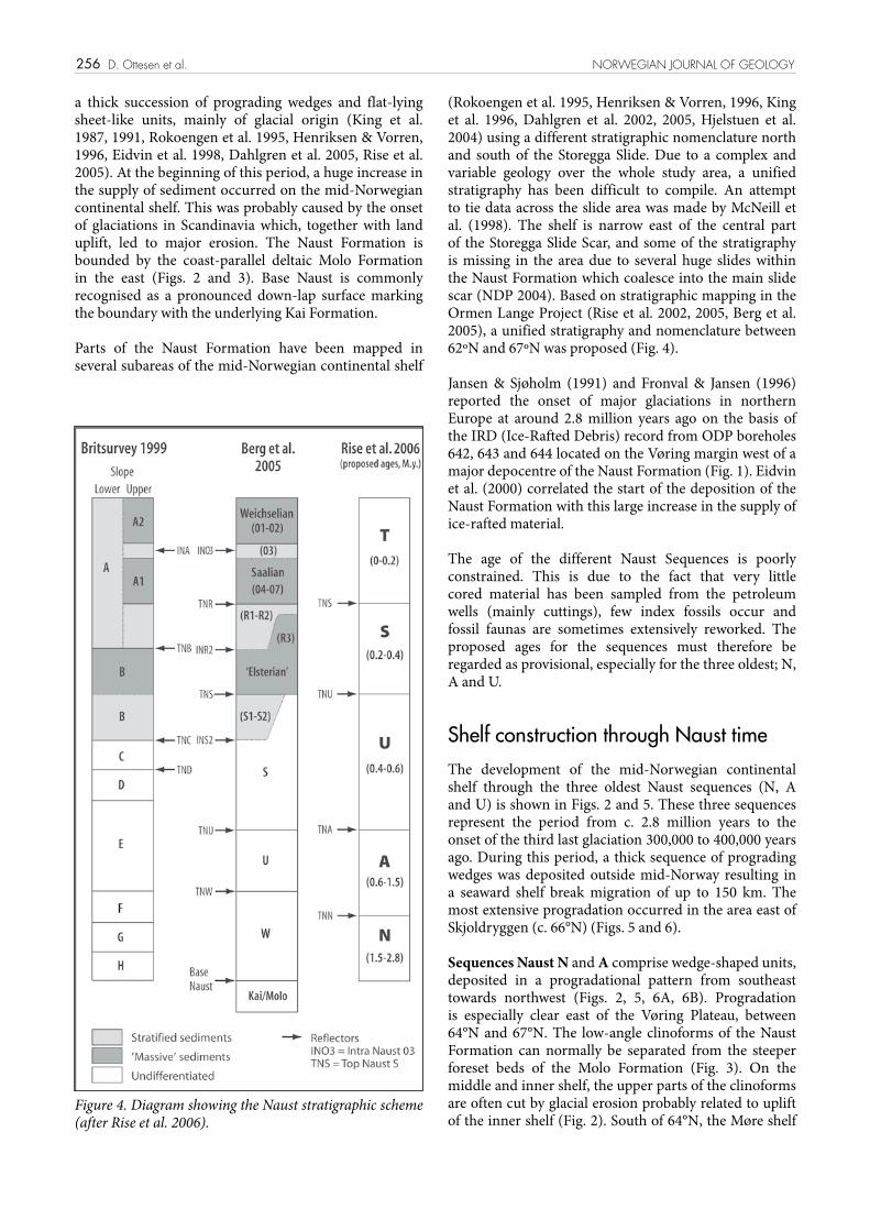
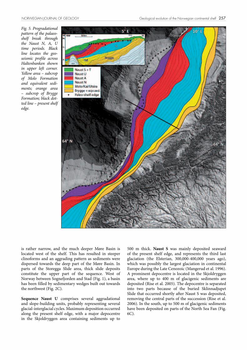
Shelf construction through Naust timeThe development of the mid-Norwegian continental shelf through the three oldest Naust sequences (N, A and U) is shown in Figs. 2 and 5. These three sequences represent the period from c. 2.8 million years to the onset of the third last glaciation 300,000 to 400,000 years ago. During this period, a thick sequence of prograding wedges was deposited outside mid-Norway resulting in a seaward shelf break migration of up to 150 km. The most extensive progradation occurred in the area east of Skjoldryggen (c. 66°N) (Figs. 5 and 6).
Sequences Naust N and A comprise wedge-shaped units, deposited in a progradational pattern from southeast towards northwest (Figs. 2, 5, 6A, 6B). Progradation is especially clear east of the Vøring Plateau, between 64°N and 67°N. The low-angle clinoforms of the Naust Formation can normally be separated from the steeper foreset beds of the Molo Formation (Fig. 3). On the middle and inner shelf, the upper parts of the clinoforms are often cut by glacial erosion probably related to uplift of the inner shelf (Fig. 2). South of 64°N, the Møre shelf
D. Ottesen et al. NORWEGIAN JOURNAL OF GEOLOGY
Figure 4. Diagram showing the Naust stratigraphic scheme (after Rise et al. 2006).
257
is rather narrow, and the much deeper Møre Basin is located west of the shelf. This has resulted in steeper clinoforms and an aggrading pattern as sediments were dispersed towards the deep part of the Møre Basin. In parts of the Storegga Slide area, thick slide deposits constitute the upper part of the sequence. West of Norway between Sognefjorden and Stad (Fig. 1), a basin has been filled by sedimentary wedges built out towards the northwest (Fig. 2C).
Sequence Naust U comprises several aggradational and slope-building units, probably representing several glacial-interglacial cycles. Maximum deposition occurred along the present shelf edge, with a major depocentre in the Skjoldryggen area containing sediments up to
500 m thick. Naust S was mainly deposited seaward of the present shelf edge, and represents the third last glaciation (the Elsterian, 300,000-400,000 years ago), which was possibly the largest glaciation in continental Europe during the Late Cenozoic (Mangerud et al. 1996). A prominent depocentre is located in the Skjoldryggen area, where up to 400 m of glacigenic sediments are deposited (Rise et al. 2005). The depocentre is separated into two parts because of the buried Sklinnadjupet Slide that occurred shortly after Naust S was deposited, removing the central parts of the succession (Rise et al. 2006). In the south, up to 500 m of glacigenic sediments have been deposited on parts of the North Sea Fan (Fig. 6C).
NORWEGIAN JOURNAL OF GEOLOGY Geological evolution of the Norwegian continental shelf
Fig. 5. Progradational pattern of the palaeo-shelf break through the Naust N, A, U time periods. Black line locates the geo-seismic profile across Haltenbanken shown in upper left corner. Yellow area – subcrop of Molo Formation and equivalent sedi-ments; orange area – subcrop of Brygge Formation; black dot-ted line – present shelf edge.
258
Fig. 6. Time thickness maps in milliseconds (two-way travel time) of the Naust Forma-tion and equivalent sediments and the depocentres of the Naust sequences.A) Main depo- centres for the Naust N sequence, B) Main depocentres for the Naust A+U sequences, C) Main depocentres for the Naust S+T sequences, D) Total Naust Formation thickness.Hachure shows the subcrop of the Molo Formation and equi-valent sediments on the shelf. E) Geoprofile of seismic line GMNR-94-310 across Halten- banken (location shown in A-D).
D. Ottesen et al. NORWEGIAN JOURNAL OF GEOLOGY
259
Sequence Naust T comprises mainly flat-lying units of massive or layered sediments from the last two glacial-interglacial cycles, the Saalian (140,000-300,000) and the Weichselian (10,000-115,000 years ago). In the south, an extensive depocentre is found on the North Sea Fan, with deposition of up to 700 m of sediments. This illustrates that the Norwegian Channel ice streams were very active during the last few glaciations (Nygård et al. 2005, 2007). The Tampen Slide is a large buried slide, c. 130,000 years old, located on the North Sea Fan (King et al. 1996, Nygård et al. 2005) (Fig. 1). This slide probably removed a large part of the Saalian sediments of the North Sea Fan. A pronounced depocentre is located in the Skjoldryggen area where 300-400 m of sediments make up the main Skjoldryggen Ridge and adjacent areas, showing that the glaciers were very active during this period.
During the last few glaciations, there is evidence that the ice sheet was divided into several fast-flowing ice streams (Ottesen et al. 2005). These were probably separated by ice domes with slow-moving ice (Ottesen et al. 2005, Rise et al. 2005). These ice streams deposited very large volumes of glacially derived sediments (Nygård et al. 2007).
The seismic profiles show a complex shelf architecture (Fig. 2). In many areas of the shelf, an upper regional unconformity is developed, marking a major change in stratal architecture (Rokoengen et al. 1995, Dahlgren et al. 2005). Over large areas off mid-Norway this surface is at the base of Naust T and represents an erosional surface made by the Elsterian Ice Sheet. However, the surface is complex and appears to have been cut at different times on different parts of the shelf. On the inner shelf this often represents an erosional surface from the last glaciation. In the Norwegian Channel west of Norway, the URU seems to be older than in other parts of the shelf.
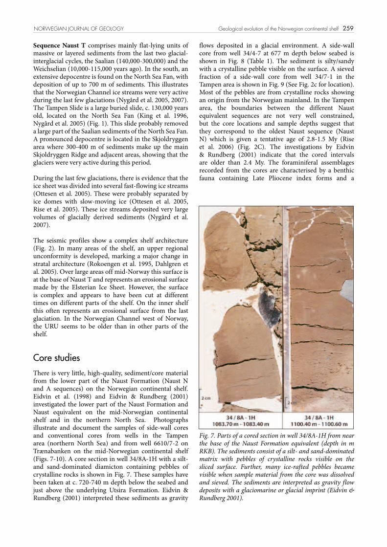
Core studiesThere is very little, high-quality, sediment/core material from the lower part of the Naust Formation (Naust N and A sequences) on the Norwegian continental shelf. Eidvin et al. (1998) and Eidvin & Rundberg (2001) investigated the lower part of the Naust Formation and Naust equivalent on the mid-Norwegian continental shelf and in the northern North Sea. Photographs illustrate and document the samples of side-wall cores and conventional cores from wells in the Tampen area (northern North Sea) and from well 6610/7-2 on Trænabanken on the mid-Norwegian continental shelf (Figs. 7-10). A core section in well 34/8A-1H with a silt- and sand-dominated diamicton containing pebbles of crystalline rocks is shown in Fig. 7. These samples have been taken at c. 720-740 m depth below the seabed and just above the underlying Utsira Formation. Eidvin & Rundberg (2001) interpreted these sediments as gravity
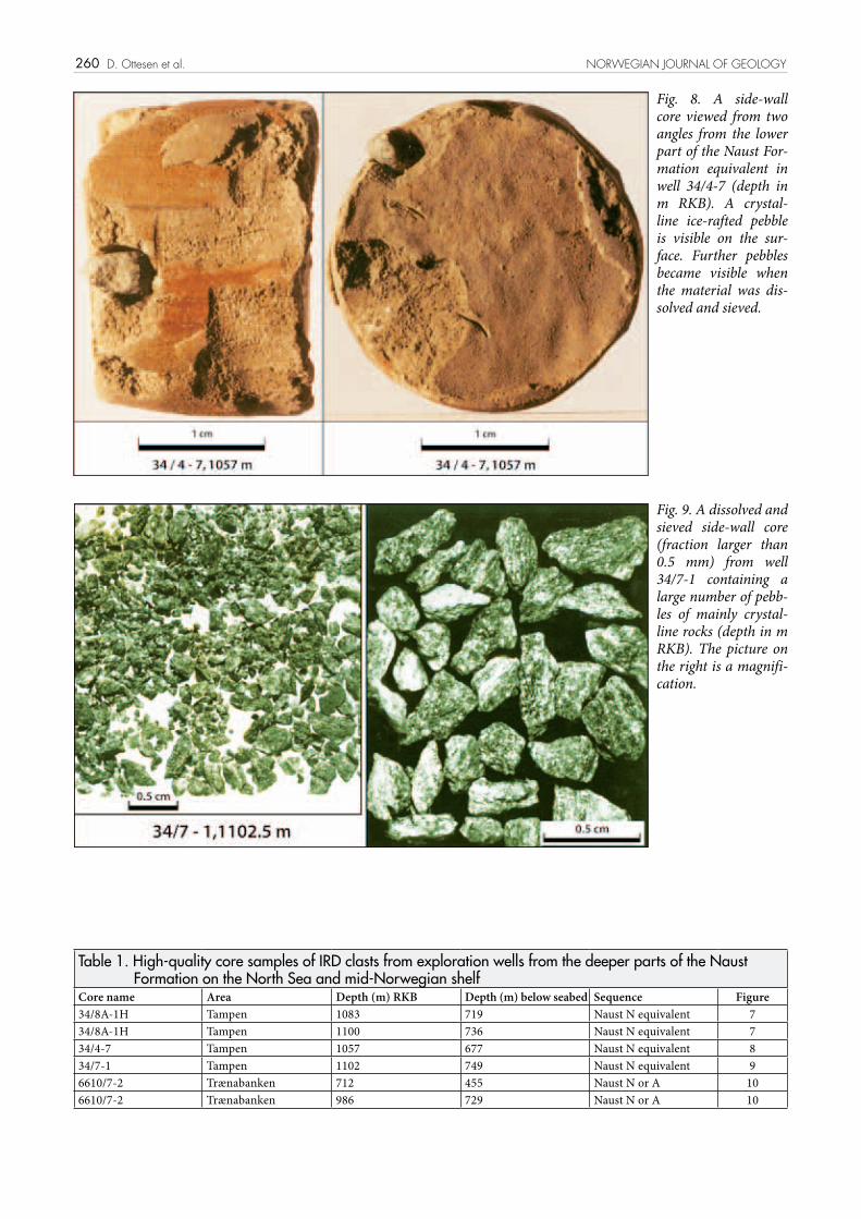
flows deposited in a glacial environment. A side-wall core from well 34/4-7 at 677 m depth below seabed is shown in Fig. 8 (Table 1). The sediment is silty/sandy with a crystalline pebble visible on the surface. A sieved fraction of a side-wall core from well 34/7-1 in the Tampen area is shown in Fig. 9 (See Fig. 2c for location). Most of the pebbles are from crystalline rocks showing an origin from the Norwegian mainland. In the Tampen area, the boundaries between the different Naust equivalent sequences are not very well constrained, but the core locations and sample depths suggest that they correspond to the oldest Naust sequence (Naust N) which is given a tentative age of 2.8-1.5 My (Rise et al. 2006) (Fig. 2C). The investigations by Eidvin & Rundberg (2001) indicate that the cored intervals are older than 2.4 My. The foraminiferal assemblages recorded from the cores are characterised by a benthic fauna containing Late Pliocene index forms and a
NORWEGIAN JOURNAL OF GEOLOGY Geological evolution of the Norwegian continental shelf
Fig. 7. Parts of a cored section in well 34/8A-1H from near the base of the Naust Formation equivalent (depth in m RKB). The sediments consist of a silt- and sand-dominated matrix with pebbles of crystalline rocks visible on the sliced surface. Further, many ice-rafted pebbles became visible when sample material from the core was dissolved and sieved. The sediments are interpreted as gravity flow deposits with a glaciomarine or glacial imprint (Eidvin & Rundberg 2001).
260 D. Ottesen et al. NORWEGIAN JOURNAL OF GEOLOGY
Fig. 8. A side-wall core viewed from two angles from the lower part of the Naust For-mation equivalent in well 34/4-7 (depth in m RKB). A crystal-line ice-rafted pebble is visible on the sur-face. Further pebbles became visible when the material was dis-solved and sieved.
Fig. 9. A dissolved and sieved side-wall core (fraction larger than 0.5 mm) from well 34/7-1 containing a large number of pebb-les of mainly crystal-line rocks (depth in m RKB). The picture on the right is a magnifi-cation.
Table 1. High-quality core samples of IRD clasts from exploration wells from the deeper parts of the Naust Formation on the North Sea and mid-Norwegian shelf
Core name Area Depth (m) RKB Depth (m) below seabed Sequence Figure34/8A-1H Tampen 1083 719 Naust N equivalent 734/8A-1H Tampen 1100 736 Naust N equivalent 734/4-7 Tampen 1057 677 Naust N equivalent 834/7-1 Tampen 1102 749 Naust N equivalent 96610/7-2 Trænabanken 712 455 Naust N or A 106610/7-2 Trænabanken 986 729 Naust N or A 10
261
planktonic fauna containing Neogloboquadrina atlantica (sinistral). On the Vøring Plateau the last occurrence of N. atlantica (sinistral) is no younger than approximately 2.4 My (Spiegler & Jansen 1989). A similar benthic and planktonic foraminiferal fauna is recorded in the side-wall cores from well 6610/7-2 on the Norwegian Sea continental shelf (Eidvin et al. 1998).
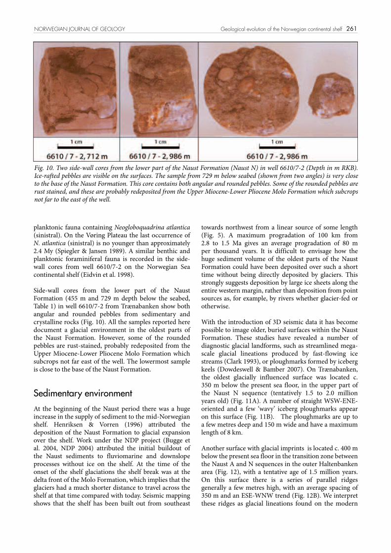
Side-wall cores from the lower part of the Naust Formation (455 m and 729 m depth below the seabed, Table 1) in well 6610/7-2 from Trænabanken show both angular and rounded pebbles from sedimentary and crystalline rocks (Fig. 10). All the samples reported here document a glacial environment in the oldest parts of the Naust Formation. However, some of the rounded pebbles are rust-stained, probably redeposited from the Upper Miocene-Lower Pliocene Molo Formation which subcrops not far east of the well. The lowermost sample is close to the base of the Naust Formation.
Sedimentary environmentAt the beginning of the Naust period there was a huge increase in the supply of sediment to the mid-Norwegian shelf. Henriksen & Vorren (1996) attributed the deposition of the Naust Formation to glacial expansion over the shelf. Work under the NDP project (Bugge et al. 2004, NDP 2004) attributed the initial buildout of the Naust sediments to fluviomarine and downslope processes without ice on the shelf. At the time of the onset of the shelf glaciations the shelf break was at the delta front of the Molo Formation, which implies that the glaciers had a much shorter distance to travel across the shelf at that time compared with today. Seismic mapping shows that the shelf has been built out from southeast
towards northwest from a linear source of some length (Fig. 5). A maximum progradation of 100 km from 2.8 to 1.5 Ma gives an average progradation of 80 m per thousand years. It is difficult to envisage how the huge sediment volume of the oldest parts of the Naust Formation could have been deposited over such a short time without being directly deposited by glaciers. This strongly suggests deposition by large ice sheets along the entire western margin, rather than deposition from point sources as, for example, by rivers whether glacier-fed or otherwise.
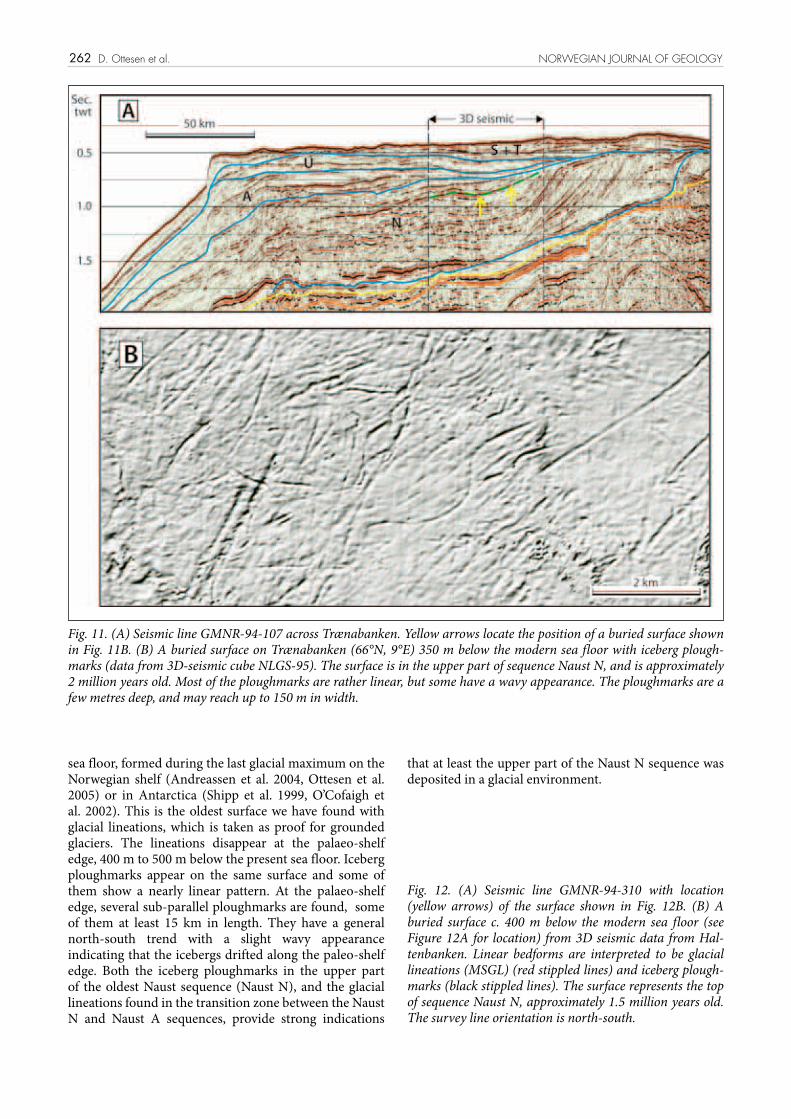
With the introduction of 3D seismic data it has become possible to image older, buried surfaces within the Naust Formation. These studies have revealed a number of diagnostic glacial landforms, such as streamlined mega-scale glacial lineations produced by fast-flowing ice streams (Clark 1993), or ploughmarks formed by iceberg keels (Dowdeswell & Bamber 2007). On Trænabanken, the oldest glacially influenced surface was located c. 350 m below the present sea floor, in the upper part of the Naust N sequence (tentatively 1.5 to 2.0 million years old) (Fig. 11A). A number of straight WSW-ENE-oriented and a few ‘wavy’ iceberg ploughmarks appear on this surface (Fig. 11B). The ploughmarks are up to a few metres deep and 150 m wide and have a maximum length of 8 km.
Another surface with glacial imprints is located c. 400 m below the present sea floor in the transition zone between the Naust A and N sequences in the outer Haltenbanken area (Fig. 12), with a tentative age of 1.5 million years. On this surface there is a series of parallel ridges generally a few metres high, with an average spacing of 350 m and an ESE-WNW trend (Fig. 12B). We interpret these ridges as glacial lineations found on the modern
NORWEGIAN JOURNAL OF GEOLOGY Geological evolution of the Norwegian continental shelf
Fig. 10. Two side-wall cores from the lower part of the Naust Formation (Naust N) in well 6610/7-2 (Depth in m RKB). Ice-rafted pebbles are visible on the surfaces. The sample from 729 m below seabed (shown from two angles) is very close to the base of the Naust Formation. This core contains both angular and rounded pebbles. Some of the rounded pebbles are rust stained, and these are probably redeposited from the Upper Miocene-Lower Pliocene Molo Formation which subcrops not far to the east of the well.
262
sea floor, formed during the last glacial maximum on the Norwegian shelf (Andreassen et al. 2004, Ottesen et al. 2005) or in Antarctica (Shipp et al. 1999, O’Cofaigh et al. 2002). This is the oldest surface we have found with glacial lineations, which is taken as proof for grounded glaciers. The lineations disappear at the palaeo-shelf edge, 400 m to 500 m below the present sea floor. Iceberg ploughmarks appear on the same surface and some of them show a nearly linear pattern. At the palaeo-shelf edge, several sub-parallel ploughmarks are found, some of them at least 15 km in length. They have a general north-south trend with a slight wavy appearance indicating that the icebergs drifted along the paleo-shelf edge. Both the iceberg ploughmarks in the upper part of the oldest Naust sequence (Naust N), and the glacial lineations found in the transition zone between the Naust N and Naust A sequences, provide strong indications
that at least the upper part of the Naust N sequence was deposited in a glacial environment.
D. Ottesen et al. NORWEGIAN JOURNAL OF GEOLOGY
Fig. 11. (A) Seismic line GMNR-94-107 across Trænabanken. Yellow arrows locate the position of a buried surface shown in Fig. 11B. (B) A buried surface on Trænabanken (66°N, 9°E) 350 m below the modern sea floor with iceberg plough-marks (data from 3D-seismic cube NLGS-95). The surface is in the upper part of sequence Naust N, and is approximately 2 million years old. Most of the ploughmarks are rather linear, but some have a wavy appearance. The ploughmarks are a few metres deep, and may reach up to 150 m in width.
Fig. 12. (A) Seismic line GMNR-94-310 with location (yellow arrows) of the surface shown in Fig. 12B. (B) A buried surface c. 400 m below the modern sea floor (see Figure 12A for location) from 3D seismic data from Hal-tenbanken. Linear bedforms are interpreted to be glacial lineations (MSGL) (red stippled lines) and iceberg plough-marks (black stippled lines). The surface represents the top of sequence Naust N, approximately 1.5 million years old. The survey line orientation is north-south.

263NORWEGIAN JOURNAL OF GEOLOGY Geological evolution of the Norwegian continental shelf
264
Conclusions1. Marine geophysical investigations have resulted in a revised and unified stratigraphy for the Late Pliocene-Pleistocene sediments of the mid-Norwegian continental shelf (the Naust Formation) between Sognefjorden and Lofoten (61°N to 68°N). Glacially derived sediments constituting the Naust Formation have been built out up to 150 km west of the Molo Formation. The Naust Formation has been subdivided into five units, N, A, U, S and T, with N representing the oldest unit, S representing the third last and T the two last glaciations.
2. Studies of high-quality sedimentary cores from the Norwegian continental shelf have revealed clasts interpreted as ice-rafted debris in the lower parts of the Naust Formation. The major part of the clasts originate from crystalline rocks and are probably derived from the adjacent Norwegian mainland.
3. Seismic 3D data from the shelf have revealed sedimentary surfaces showing evidence for grounded ice sheets (glacial lineations) in the transition zone between the two oldest Naust sequences on the outer shelf (Naust N and A), approximately 1.5 million years ago.
4. Seismic 3D data from the shelf have revealed sedimentary surfaces with a glacial influence (iceberg ploughmarks) back to the upper part of the oldest Naust sequence (Naust N), approximately 2 million years ago.
5. All available information, i.e. glacial lineations, iceberg ploughmarks, IRD from the lower part of the Naust Formation, and the very high accumulation rate, support that the Naust Formation is mainly developed in a glacial environment.
Acknowledgments We would like to thank the Ormen Lange and the NDP Seabed projects for access to seismic and other data and permission to publish these results. We also thank Statoil for supplying sidewall cores and Finn Moe at the Norwegian Petroleum Directorate for photos. SINTEF Petroleum Research is thanked for access to high-resolution seismic data. An early version of the manuscript was read by J. Dowdeswell and R. Bøe. The help and contributions from all these persons and institutions are grate-fully acknowledged as are the constructive comments of S. Henriksen, T. Nielsen and A. Nygård.
References
Aarseth, I. 1997: Western Norwegian fjord sediments: age, volume, stratigraphy, and role as temporary depository during glacial cycles. Marine Geology 143, 39-53.
Andreassen, K., Nielsen, L.C., Rafaelsen, B. & Kuilman, L. 2004: Three-dimensional seismic data from the Barents Sea margin reveal evidence of past ice streams and their dynamics. Geology 32, 729-732.
Berg, K., Solheim, A. & Bryn, P. 2005: The Pleistocene to recent geological development of the Ormen Lange area. Marine and Petroleum Geology 22, 45-56.
Blystad, P., Brekke, H., Færseth, R.B., Larsen, B.T., Skogseid, J. & Tørudbakken, B. 1995: Structural elements of the Norwegian continental shelf. Part II: The Norwegian Sea Region. Norwegian Petroleum Directorate Bulletin 8. 45 pp.
Bondevik, S., Svendsen, J.I., Johnsen, G., Mangerud, J. & Kaland, P.E. 1997: The Storegga tsunami along the Norwegian coast, its age and runup. Boreas 32, 476-483.
Britsurvey 1999: Seabed Project. Geological and Geophysical Interpretation in Møre/Vøring Area, Phase III, Stage 1. Seabed Project Report No. Sp-26-BS-02-99. Final Report.
Bryn, P., Berg, K., Forsberg, C.F., Solheim, A. & Kvalstad, T. 2005: Explaining the Storegga Slide. Marine and Petroleum Geology 22, 11-19.
Bugge, T. 1983: Submarine slides on the Norwegian continental margin, with special emphasis on the Storegga area. Continental Shelf Institute Publication 110. 152 pp.
Bugge, T., Knarud, R. & Mørk, A. 1984: Bedrock geology on the mid-Norwegian continental shelf. In: Spencer, A.M., Johnsen, S.O., Mørk, A., Nysæther, E., Sonstad, P. and Spinnanger, Å. (Eds.). Petroleum Geology of the North Norwegian Margin. Graham and Trotman, London, 271-283.
Bugge, T., Belderson, R.H. & Kenyon, N.H. 1988: The Storegga Slide. Philosophical Tranasactions of the Royal Society of London 325, 1586, 357-388.
Bugge, T., Eidvin, T., Smelror, M., Ayers, S., Ottesen, D., Rise, L., Andersen, E.S., Dahlgren, K.I.T., Evans, D. & Henriksen, S. 2004: The Middle and Upper Cenozoic depositional systems on the Mid-Norwegian continental margin. In: Martinsen, O. (Ed.), Deep water sedimentary systems of Arctic and North Atlantic Margins. Norsk Geologisk Forening abstracts and Proceedings 1, 14-15.
Clark, C.D. 1993: Mega-scale glacial lineations and cross-cutting ice-flow landforms. Earth Surface Processes and Landforms 18, 1-29.
Dahlgren, K.I.T., Vorren, T.O. & Laberg, J.S. 2002: Late Quaternary glacial development of the mid-Norwegian margin – 65º to 68ºN. Marine and Petroleum Geology 19, 1089-1113.
Dahlgren, K.I.T., Vorren, T.O., Stoker, M.S., Nielsen, T., Nygård, A. & Sejrup, H.P. 2005: Late Cenozoic prograding wedges on the NW European continental margin: their formation and relationship to tectonics and climate. Marine and Petroleum Geology 22, 1089-1110.
Dalland, A., Worsley, D. & Ofstad, K. 1988: A lithostratigraphic scheme for the Mesozoic and Cenozoic succession offshore mid- and northern Norway. Norwegian Petroleum Directorate Bulletin 4, 65 pp.
Dowdeswell, J.A. & Bamber, J. 2007: Keel depths of modern Antarctic icebergs and implications for sea-floor scouring in the geological record. Marine Geology 243, 120-131.
Dowdeswell, J.A., Ottesen, D. & Rise, L. 2006: Flow-switching and large-scale deposition by ice streams draining former ice sheets. Geology 34, 313-316.
Eidvin, T. & Rundberg, Y. 2001: Late Cainozoic stratigraphy of the Tampen area (Snorre and Visund fields) in the northern North Sea, with emphasis on the chronology of early Neogene sands. Norsk Geologisk Tidsskrift 81, 119-160.
Eidvin, T., Brekke, H., Riis, F. & Renshaw, D. K. 1998: Cenozoic stratigraphy of the Norwegian Sea continental shelf, 64ºN - 68ºN. Norsk Geologisk Tidsskrift 78, 125-151.
D. Ottesen et al. NORWEGIAN JOURNAL OF GEOLOGY

265NORWEGIAN JOURNAL OF GEOLOGY Geological evolution of the Norwegian continental shelf
Eidvin, T., Jansen, E., Rundberg, Y., Brekke, H. & Grogan, P. 2000: The upper Cainozoic of the Norwegian continental shelf correlated with the deep sea record of the Norwegain Sea and the North Atlantic. Marine and Petroleum Geology 17, 579-600.
Eidvin, T., Bugge, T. & Smelror, M. 2007: The Molo Formation, deposited by coastal progradation on the inner Mid-Norwegian continental shelf, coeval with the Kai Formation to the west and the Utsira Formation in the North Sea. Norwegian Journal of Geology 87, 35-102.
Fronval, T. & Jansen, E. 1996: Late Neogene paleoclimates and paleoceanography in the Iceland-Norwegian Sea: evidence from the Iceland and Vøring Plateaus. In: Thiede, J., Myhre, A. M., Firth, J. V., John, G. L. & Ruddiman, W. F. (eds.), Proceedings of the Ocean Drilling Program, Scientific Results 151, Friesens, Canada, 455-468.
Henriksen, S. & Vorren, T. O. 1996: Late Cenozoic sedimentation and uplift history on the mid-Norwegian continental shelf. Global and Planetary Change 12, 171-199.
Henriksen, S. & Weimer, P. 1996: High-frequency depositional sequences and stratal stacking patterns in Lower Pliocene coastal deltas, Mid-Norwegian continental shelf. American Association of Petroleum Geologists Bulletin 80 (12), 1867-1895.
Henriksen, S., Fichler, C., Grønlie, A., Henningsen, T., Laursen, I., Løseth, H., Ottesen, D. & Prince, I. 2005: The Norwegian Sea during the Cenozoic. In: Wandås, B., Nystuen, J.P. & Eide, E.A. (eds.): Onshore-Offshore Relationships on the North Atlantic Margin, Norwegian Petroleum Society Special Publication 12, 111-133.
Hjelstuen, B.O., Sejrup, H.P., Haflidason, H., Nygård, A., Berstad, I.M. & Knorr, G. 2004: Late Quaternary seismic stratigraphy and geological development of the south Vøring margin, Norwegian Sea. Quaternary Science Reviews 23, 1847-1865.
Isaksen, D. & Tonstad, K. 1989: A revised Cretaceous and Tertiary lithostratigraphic nomenclature for the Norwegian North Sea. Norwegian Petroleum Directorate Bulletin 5, 59 pp.
Jansen, E. & Sjøholm, J. 1991: Reconstruction of glaciation over the past 6 Myr from ice- borne deposits in the Norwegian Sea. Nature 349, 600-603.
Japsen, P. & Chalmers, J.A. 2000: Neogene uplift and tectonics around the North Atlantic: overview. Global and Planetary Change 24, 165-173.
King, E.L., Sejrup. H.P., Haflidason, H., Elverhøi, A. & Aarseth, I. 1996: Quaternary seismic stratigraphy of the North Sea Fan: glacially-fed gravity flow apron, hemipelagic sediments, and large submarine slides. Marine Geology 130, 293-315.
King, L.H., Rokoengen, K. & Gunleiksrud, T. 1987: Quaternary seismostratigraphy of the Mid Norwegian Shelf, 65°-67°30’N – a till tongue stratigraphy. Continental Shelf Institute Publication 114, 58 pp.
King, L. H., Rokoengen, K., Fader, G. B. J. & Gunleiksrud, T. 1991: Till-tongue stratigraphy. Geological Society of America Bulletin 103, 637-659.
Longva, O. & Thorsnes, T. (eds.) 1997: Skagerrak in the past and at the present - an integrated study of geology, chemistry, hydrography and microfossil ecology. Norges geologiske undersøkelse Special Publication 8, 100 pp.
Lundin, E.R. & Doré, A.G. 2002: Mid-Cenozoic post-breakup deformation in the “passive” margins bordering the Norwegian- Greenland Sea. Marine and Petroleum Geology 19, 79-93.
Mangerud, J., Jansen, E. & Landvik, J.Y. 1996: Late Cenozoic history of the Scandinavian and Barents Sea ice sheets. Global and Planetary Change 12, 11-26.
McNeill, A.E., Salisbury, R.S.K., Østmo, S.R., Lien, R. & Evans, D. 1998: A regional shallow stratigraphic framework off mid-Norway and observations of ’special features’. Annual Offshore Technology Conference no. 30, Houston vol. 1, 97-110.
Norwegian Deepwater Programme 2004: Mid- to Late Cenozoic Geomodel of the Mid-Norwegian Continental Margin. Model Volume. Norwegian Deepwater Programme. Seabed Project Phase II. Report no. SP2-02-FS-01R-00001-04 compiled by Fugro Survey Limited. 108 pp.
Nygård, A., Sejrup, H.P., Haflidason, H. & Bryn, P. 2005: The glacial North Sea Fan, southern Norwegian Margin: architecture and evolution from the upper continental slope to the deep-sea basin. Marine and Petroleum Geology 22, 71-84.
Nygård, A., Sejrup, H.P., Haflidason, H., Lekens, W.A.H., Clark, C.D. & Bigg, G.R. 2007: Extreme sediment and ice discharge from marine based ice streams, new evidence from the North Sea. Geology 35, 395-398.
Ó Cofaigh, C., Pudsey, C.J., Dowdeswell, J.A. & Morris, P. 2002: Evolution of subglacial bedforms along a paleo-ice stream, Antarctic Peninsula continental shelf. Geophysical Research Letters, 29 (8), 10.1029/2001GL014488.
Ottesen, D., Dowdeswell, J.A., & Rise, L. 2005: Submarine landforms and the reconstruction of fast-flowing ice streams within a large Quaternary ice sheet: the 2,500 km-long Norwegian-Svalbard margin (57º to 80ºN). Geological Society of America Bulletin 117, 1033-1050.
Riis, F. 1996: Quantification of Cenozoic vertical movements of Scandinavia by correlation of morphological surfaces with offshore data. Global and Planetary Change 12, 331-357.
Rise, L. 1988: Grunnseismisk nett på midtnorsk kontinentalsokkel. Kart i målestokk 1: 1 000000. Continental Shelf Institute Publication 116.
Rise, L., Ottesen, D., Larsen, E., Lundin, E., Olsen, L., & Thorsnes, T. 2002: Large scale development of the mid-Norwegian shelf and margin with emphasis on the last 3 million years. Norges geologiske undersøkelse report 2002.015, Rev.1, 200 pp.
Rise, L., Ottesen, D., Berg, K. & Lundin, E. 2005: Large-scale development of the mid-Norwegian margin during the last 3 million years. Marine and Petroleum Geology 22, 33-44.
Rise, L. Ottesen, D., Longva, O., Solheim, A., Andersen, E.S. & Ayers, S. 2006: The Sklinnadjupet slide and its relation to the Elsterian glaciation on the mid-Norwegian margin. Marine and Petroleum Geology 23, 569-583.
Rokoengen, K., Rise, L., Bugge, T. & Sættem, J. 1988: Berg-grunnsgeologi på midtnorsk kontinentalsokkel. Kart i målestokk 1: 1 000 000. Continental Shelf Institute Publication 118.
Rokoengen, K., Rise, L., Bryn, P., Frengstad, B., Gustavsen, B. Nygaard, E. & Sættem, J. 1995: Upper Cenozoic stratigraphy on the mid-Norwegian continental shelf. Norsk Geologisk Tidsskrift 75, 88-104.
Sejrup, H.P., Aarseth, I., Haflidason, H., Løvlie, R., Bratten, Å., Tjøstheim, G., Forsberg, C.F. & Ellingsen, K.L. 1995: Quaternary of the Norwegian Channel: glaciation history and paleoceanography. Norsk Geologisk Tidsskrift 75, 65-87.
Sejrup, H.P., Larsen, E., Haflidason, H., Berstad, I.M., Hjelstuen, B.O., Jonsdottir, H., King, E.L., Landvik, J.Y., Longva. O., Nygård, A., Ottesen, D., Raunholm, S., Rise, L. & Stalsberg, K. 2003: Configuration, history and impact of the Norwegian Channel Ice Stream. Boreas 32, 18-36.
Shipp, S.S., Anderson, J.B., & Domack, E.W. 1999: Late Pleistocene-Holocene retreat of the West Antarctic Ice-Sheet system in the Ross Sea: Part 1 – Geophysical results. Geological Society of America Bulletin 111, 1486-1516.
Sigmond, E.M.O. 1992: Bedrock map. Norway and adjacent ocean areas. Scale 1: 3 mill. Norges geologiske undersøkelse, Trondheim.
Sigmond, E.M.O. 2002: Geological map. Land and Sea Areas of Northern Europe. Scale 1: 4 million. Norges geologiske undersøkelse, Trondheim.
Solheim, A., Bryn, P., Sejrup, H.P., Mienert, J. & Berg, K. 2005: Ormen Lange – an integrated study for the safe development of a deep-water gas field within the Storegga Slide Complex, NE Atlantic margin; executive summary. Marine and Petroleum Geology 22, 1-9.
Spiegler, D. & Jansen, E., 1989: Planctonic foraminifer biostratigraphy of Norwegian Sea sediments: ODP Leg 104. In: Eldholm, O., Thiede, J., Taylor, E. (eds.): Proceedings of the Ocean Drilling Program , Scientific Results 104, 681-696.