geologic map of the indian well wilderness quadrangle ... · indian well wilderness quadrangle,...
TRANSCRIPT
Geologic Map of the Indian Well Wilderness Quadrangle,
Socorro County, New Mexico
By
Colin T. Cikoski, Richard M. Chamberlin, Ted L. Eggleston, and Susan C. Kent
June 2010
New Mexico Bureau of Geology and Mineral Resources
Open-file Digital Geologic Map OF-GM 201
Scale 1:24,000
This work was supported by the U.S. Geological Survey, National Cooperative Geologic Mapping Program (STATEMAP) under USGS Cooperative Agreement 10HQPA0003
and the New Mexico Bureau of Geology and Mineral Resources.
New Mexico Bureau of Geology and Mineral Resources 801 Leroy Place, Socorro, New Mexico, 87801-4796
The views and conclusions contained in this document are those of the author and should not be interpreted as necessarily representing the official policies,
either expressed or implied, of the U.S. Government or the State of New Mexico.
OF-GM-201_Revised 05.08.12
GEOLOGIC MAP OF THE INDIAN WELL WILDERNESS 7.5 MINUTE QUADRANGLE,
SOCORRO COUNTY, NEW MEXICO
Colin T. Cikoski1, Richard M. Chamberlin2, Ted L. Eggleston3 and Susan C. Kent4
June, 2010
First Revision : August 9, 2010 Second Revision: May 8, 2012
1 Earth and Environmental Science Dept., New Mexico Tech, 801 Leroy Pl., Socorro, NM, 87801 2 New Mexico Bureau of Geology and Mineral Resources, 801 Leroy Pl., Socorro, NM, 87801 3 AMEC Mining and Metals, P.O. Box 67, Hillside, CO USA, 81232 4 Kent and Sullivan Inc. 312 Tyee St., Soldotna AK, 99669
NEW MEXICO BUREAU OF GEOLOGYAND MINERAL RESOURCES OPEN-FILE GEOLOGIC MAP SERIES
OF-GM-201
New Mexico Bureau of Geology and Mineral Resources A division of New Mexico Institute of Mining and Technology
1
OF-GM-201_Revised 05.08.12
DESCRIPTION OF MAP UNITS
Post Santa Fe Group: Post-Santa Fe Group includes all surficial deposits inset into the Sierra Ladrones Formation and intermontane surficial deposits of middle Pleistocene to Holocene age. af Artificial fill (Recent) — Compacted fill, as roadway subgrades along Interstate 25. Thickness 0–6 m. Qfh Younger valley fill, axial fluvial facies, historic channels (Recent) — River channels active prior to ca. 1950 (pre-conveyance channel) flowed along the west side of the floodplain. Present-day channels are forced to flow east of the conveyance channel. Qf Younger valley fill, axial-fluvial facies (Holocene to uppermost Pleistocene) — Floodplain and channel deposits of Rio Grande; consists mostly of clay to sand. Near San Acacia this unit grades down to well sorted gravel at basal scour surface as much as 30 m below floodplain (McGrath and Hawley, 1987). Intertongues with Qa. Thickness 0–30 m. Qa Younger valley alluvium, piedmont facies (Holocene to uppermost Pleistocene) — Active channel, low terrace and alluvial-fan deposits of tributary arroyos; poorly sorted, non-indurated, gravel, sand, silt, and clay. Formed during last major episode of valley entrenchment and backfilling. Thickness 0–30 m. Qae Eolian sands and alluvium undivided (Holocene to uppermost Pleistocene) — Thin, fine-grained, sand sheets locally cover, or are mixed with, young alluvium in area near Canyon Trail. Found downwind of sandstone-rich bedrock (Tpe). Eolian sands also accumulate on the lee side of ridges. Thickness is 0 to 5 meters. Qai –Incised alluvium (Holocene to uppermost Pleistocene) — Mapped where deep gullies (~3 m) are cut in young valley fills near the mouths of tributary arroyos. Found near Elmendorf, in an area of ongoing uplift (C-C’). Exposed thickness 0-4 m. Qc – Colluvium (Holocene to Pleistocene) — Talus, colluvium, rock-fall deposits and some debris-flow deposits on steep to moderate slopes in the Chupadera Mountains. A notable 25m-long train of large (3x3m) jumbled blocks derived from the Blue Canyon Tuff apparently represents a rock-avalanche deposit that must have recently crossed the Chupadera Peak trail area from north to south (train trends 350 at 0320406E/3745952N). Includes gravelly slope wash on erosion surfaces cut in poorly consolidated upper Cenozoic deposits in Socorro Basin. Primarily shown where colluvium masks underlying map units. Widespread colluvial veneers on dissected piedmont slopes (QTsp) are generally not delineated. Usually 0.3–3 m thick, as much as 10 m thick. Qls – Landslide blocks (Holocene to Pleistocene) — Large blocks of basalt lava, down slope from and apparently derived from a basalt-capped cuesta (Tbo) east of Chupdera Spring. 0-10 m thick. Qt – Terrace alluvium, undivided (latest Pleistocene to Holocene) — Narrow terrace gravels along some larger arroyos at approximately 2, 3, and 6 meters above the active channel. Thin deposits (0-3m) consist of poorly sorted, angular to rounded, cobbly gravels to pebbly sands with clast lithologies from upstream sources. Qvn Older valley alluvium, piedmont facies, north (middle to upper Pleistocene) — Inset terrace and alluvial-fan deposits of east flowing tributary arroyos associated with five episodes of valley entrenchment and backfilling (Qnv1 to Qvn5, oldest to youngest
2

OF-GM-201_Revised 05.08.12
respectively); mapped only north of the BDA fault. Poorly sorted, angular to rounded, bouldery to pebbly gravels, gravelly sand and muddy silts were derived from the Chupadera Mountains. Sparse schist clasts are notable east of Chupadera Spring and red rhyolite clasts are abundant east of Chupadera Peak. Mostly reddish and non-indurated, but uppermost beds are locally cemented by pedogenic carbonate horizons 0.1 m to 0.6 m thick. Thickness 0–24 m. Qvs Older valley alluvium, piedmont facies, south (middle to upper Pleistocene) — Inset terrace and alluvial-fan deposits of tributary arroyos associated with two apparent episodes of valley entrenchment and backfilling; mapped only south of the BDA fault. Poorly to moderately sorted, angular to rounded, sandy to bouldery deposits associated with graded surfaces that project well above the Rio Grande floodplain. Younger deposits southeast of Willow Springs (Qvs2) contain a mix of light grey tuffs and dark gray andesites. Older fan deposits near Tiffany Canyon (Qvs1) contain crystal-rich tuff clasts from the southeastern Magdalena Mountains. Exposed thickness 0-6 m. Qvof Older valley fill, axial fluvial facies, Rio Grande terrace deposits (middle to upper Pleistocene) — Light gray to light yellowish brown, well sorted sand and gravel. Well rounded to subrounded quartzite, mottled chert, granite, schist and moderately abundant volcanic pebbles (latter mostly well rounded) are typical of the axial-river deposits. Locally contains rare obsidian pebbles that are generally not seen in older river beds (QTsf). 0-2m thick where unconformable on Popotosa Fm.; appears to thicken southward. Qvot – Older valley fill, piedmont to axial river transitional facies (middle to upper Pleistocene) — Reddish-orange muddy sands and sands flanking deposits of Qvof near Tiffany Canyon, locally gypsiferous. Basal contact not exposed, about 0-20m thick. Qpu – Piedmont deposits undifferentiated (upper to lower Pleistocene) — Coarse debris flows and poorly sorted gravels, sand and mud deposited on small-catchment, high-gradient alluvial fans at east flank of Chupadera Mountains. Contains buried soils similar to those in QTsp; but not demonstrated to intertongue with QTsf. Probably represents locally continuous aggradation, equivalent to QTsp and older Qvn and Qvs deposits. Base not exposed; locally 30-60 m thick.
Santa Fe Group Intermontane basin fill of the Rio Grande rift; regionally ranges from latest Oligocene to early Pleistocene (Chapin and Cather, 1994). As redefined by Machette, 1978, includes the Pliocene and Pleistocene valley fill of the Sierra Ladrones Formation (of Machette, 1978), and latest Oligocene to late Miocene bolson fill of the Popotosa Formation in the central Rio Grande rift (Denny, 1940). Intercalated volcanic units are usually given formation status (Osburn and Chapin, 1983). Upper Santa Fe Group QTs- Sierra Ladrones Formation (lower Pleistocene to lower Pliocene) — Late-stage basin fill of the Rio Grande valley characterized by an axial-fluvial facies (ancestral Rio Grande) and intertonguing piedmont facies (large alluvial fans) derived from adjacent mountain ranges. Axial-river deposits are as much as 330 m thick in a municipal water well near Socorro (Chamberlin, 1999). QTsf Sierra Ladrones Formation, axial fluvial facies (lower Pleistocene to lower Pliocene) — Mostly well sorted, light-gray to pale yellowish brown, sand and well
3
OF-GM-201_Revised 05.08.12
rounded pebbly gravel lenses; locally showing southerly paleocurrent directions. Gravel lenses contain well-rounded to subrounded clasts of quartzite, mottled chert (Pedernal type), granite, schist and variety of volcanic rocks (most of latter are commonly well rounded). Rare exposures of greenish mud (overbank deposits or abandoned channel fills) and reddish-orange muddy sands (distal fan deposits) are present. Poorly exposed and often mantled by thin colluvium. Near Burro Well, approximately 2 m of uppermost QTsf beds lie in slight angular unconformity on Popotosa Fm. A 0.5º southward tectonic tilt on the river beds implies they are preserved in a southward thickening wedge, at about 8m /km (Section C-C’). North of the BDA fault, QTsf may be as thick as 330 m. QTsp Sierra Ladrones Formation, piedmont facies (lower Pleistocene to upper Pliocene) — Reddish orange to reddish brown, poorly consolidated , volcanic-rich, angular to subrounded, conglomerates, conglomeratic sandstones, muddy sandstones, silty mudstones and unconsolidated equivalents (e.g. gravels); generally fining to the east. Cobble to rare boulder gravels show lateral variation in clast lithologies indicating eastward transport from the Chupadera Mountains. Uppermost QTsp beds form a gently south tilted veneer (0-15 m thick), unconformable on Popotosa Fm., west of Burro Well. Locally contains buried pedogenic carbonate horizons in area north of the BDA fault, where it is as much as 330m thick. Tsp Middle Santa Fe Group, piedmont deposits, unnamed transition unit (latest Miocene to earliest Pliocene?) — Poorly exposed, pebble conglomerates, sandstones and rare mudstones. Conglomerates contain moderately-well sorted, subangular to rounded clasts of dominantly light gray welded tuffs mixed with rare rounded basalts and traces of vein quartz. Pebble imbrications indicate southeasterly paleocurrent directions. Sandstone and mudstone beds found only at southeast end of the outcrop belt (in narrow graben on the footwall of BDA fault). Basal contact not exposed, but is probably an unconformity on underlying Popotosa Fm. May represent a lower Sierra Ladrones piedmont facies, recycled from subjacent Popotosa conglomerates. Mapped separately from nearby QTsp beds due to distinctly different clast suite. Exposed thickness ~ 95 m. Lower Santa Fe Group Tp- Popotosa Formation (locally middle Miocene to upper Miocene) — Bolson fill of the Miocene “Bosque del Apache” Basin (east-tilted half graben) of the central Rio Grande rift. Locally subdivided into facies/members based on clast suites of volcanic-rich conglomerates, bulk grain size and bedforms that reflect depositional environments, general paleocurrent domains, and general stratigraphic position. Conglomerates in the “upper Popotosa Formation” (informally defined) contain sparse to rare non-volcanic clasts derived from Paleozoic formations now exposed east of the Rio Grande. Maximum total thickness in Bosque Basin is about 2 km, near the Canyon Trail (A-A’). A corresponding total thickness within Chupadera uplift (Tptu below 9.8 Ma Tbo, near Chupadera Spring) is about 250 m. Tpfb – Popotosa Formation, basaltic boulder bed (upper Miocene) — Boulder bed contains medium gray to black, massive to vesicular, subrounded basaltic boulders, as much as 0.5 m across, mixed with minor tuff cobbles and rare andesitic pebbles. Sparsely phyric olivine basalt boulders imply derivation from a nearby fault scarp of Miocene age that offset Tbo. Base not exposed, inferred conformable with underlying Tptu. Maximum thickness about 10m.
4

OF-GM-201_Revised 05.08.12
Tptu – Popotosa Formation undivided, lower to upper, tuff-dominated facies (middle to upper Miocene) — Pebble to cobble conglomerates and sandstones within the Chupadera uplift near Chupadera Spring; locally capped by the 9.8 Ma basalt of Olney Ranch (Tbo). Light brownish gray conglomerate and conglomeratic sandstone beds contain abundant subangular to rounded pebbles and cobbles of rhyolitic tuffs with minor andesitic porphyries; tuff boulders are locally present. Gravel sizes generally fine upwards; paleocurrent directions are westerly. Rare clasts of red siltstone (Abo type) can be found in float and poorly exposed upper Popotosa beds about 30 m below the basalt capped cuesta (Tbo) near Chupadera Spring. Basal contact is generally poorly exposed. Total thickness near Chupadera Spring (below Tbo) is about 250m. Tpft1 – Popotosa Formation, upper, tuff-dominated conglomerates and sandstones (upper Miocene) — Poorly exposed conglomerates, sandstones and rare mudstones on footwall of the BDA fault. Conglomerate beds are poorly sorted with angular to subrounded clasts of dominantly rhyolitic tuff, sparse andesite porphyries and rare non-volcanic clasts. Paleocurrent directions are southwesterly. Uppermost beds are intercalated with the basalt of Broken Tank (Tbt). Exposed thickness is 280 m. Tpft2 – Popotosa Formation, upper, tuff-dominated conglomerates and conglomeratic sandstones (upper Miocene) — Similar to Tpft1, but this unit is somewhat coarser (more cobbly) with greater proportion of andesitic and non-volcanic clasts Thickness is 70 m. Tps – Popotosa Formation, fluvial sandstone facies (middle to upper Miocene) — Moderately to poorly cemented, massive (planar?) to trough cross bedded sandstones and rare channel-shaped conglomerates. Thin mudstones, with desiccation cracks, are locally common near the south end of outcrop belt. Conglomerates contain poorly sorted, subangular to rounded pebbles with a clast suites that range between tuff-dominated (with sparse andesite) and andesite dominated with abundant scoria (with sparse tuffs). Non-volcanic clasts are absent near the base but become notably present (~1-2%) in conglomeratic beds near the top. Paleocurrents are dominantly southwesterly. Locally contains a few thin eolian sandstones. Basal and upper contacts are conformable. Exposed thickness is 320 m. Tpfi – Popotosa Formation, interbedded clast suite facies (middle Miocene) — Narrow, down faulted (almost horse like) outcrop belts of conglomerate and conglomeratic sandstone show distinct interbedding of tuff-dominated and andesite-dominated clast suites. Tuff-rich conglomerate beds are more poorly sorted and coarser (cobbly) compared to interlayered, pebbly andesite-rich and scoria-rich beds. Paleocurrent directions are to southwest and to southeast. Basal contact is conformable with underlying Tps. Minimum exposed thickness is 95 m. Tpe – Popotosa Formation, eolian sandstone facies (middle to upper Miocene) — Poorly cemented, poorly to well exposed, light gray to buff, high-angle cross bedded, fine-grained sandstones; locally interlayered with minor planar bedded, pebbly (fluvial) sandstones (Tps-type) and some channel-shaped conglomerates (Tpa-type). Eolian beds are 1-10 m thick and steepest cross beds (slip faces) generally dip easterly. Fine sand grains consist mostly of aphyric cryptocrystalline rhyolite, fine-grained porphyry and oscillatory zoned plagioclase. Exposed thickness is 100 m. Tpa - Popotosa Formation, andesite-dominated conglomeratic facies (upper Miocene) — Light- to medium-brownish gray, conglomerates, conglomeratic sandstones, sandstones (Tps type) and rare thin bedded mudstones; along with a few intercalated eolian sandstone beds (Tpe type). The latter are often exposed on steep sided cuestas, where difficult to show at
5
OF-GM-201_Revised 05.08.12
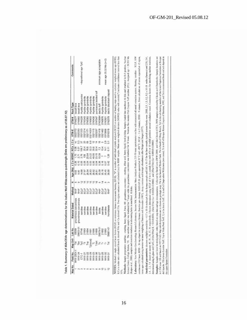
map scale (e.g. Canyon Trail area). Conglomerates contain mostly angular to subrounded pebbles to cobbles of varicolored andesitic lavas (porphyries), with moderately abundant orangish brown, finely vesicular, andesitic scoria and sparse rhyolitic tuffs. Rare red siltstone pebbles, occasionally with white reduction spots, were almost certainly derived from exposures of the Permian Abo Formation, now found east of the Rio Grande. Andesitic boulders are locally present near Elmendorf. Paleocurrents are northwesterly. Basal contact is generally gradational into Tpe. A latest Clarendonian depositional age (ca. 9-11 Ma) for Tpa is provided by a partial fossilized skeleton of an oreodont (Merchyus major major) found embedded in this unit about 500 m north of the Canyon Trail (Morgan et al., 2009). Maximum exposed thickness is 120 m. Tpt2 - Popotosa Formation, medial tuff-dominated conglomerate facies with pumiceous sandstones (middle Miocene) — Medium to light gray and light brownish gray conglomerates, conglomeratic sandstones, and minor reddish mudstones . Four discontinuously exposed pumiceous sandstone beds locally define the top and basal depositional contacts of this facies. Pebble to cobble conglomerates are dominated by subangular to rounded, purplish to light grey, mostly crystal-poor, rhyolitic tuffs, with rare andesitic lava pebbles, rounded scoria clasts, and traces of basalt. Non-volcanic clasts are absent. Basal contact is conformable with Tpt1. Sanidine crystals from rhyolitic pumice, collected near crossing of I-25 and the Chupadera Peak trail, yield a 40Ar/39Ar age of 14.68 ± 0.05 Ma (Table 1, no.3). Field relationships and age spectra suggest this is the approximate depositional age of the pumiceous sandstone bed. Thickness ranges from 50 to 70 m . Tpt1 – Popotosa Formation, basal tuff-dominated conglomerate facies (middle Miocene) — Light gray to brownish gray pebble to boulder conglomerates with few interbedded pebbly sandstones and rare thin mudstones; generally poorly cemented and poorly exposed. Conglomerates are poorly to moderately sorted, with angular to rounded clasts, medium to thick bedding and rare cross-stratification. Crystal poor and moderately crystal-rich, light gray to grayish red, welded tuffs derived from regional ignimbrite sheets (Osburn and Chapin, 1983) dominate the clast suite. Rare clast types, such as basaltic andesite with sparse iddingsite, occur near the base of this unit and andesitic porphyry to scoria are present toward the top. Boulder beds are well exposed about 300m south of the Chupadera Peak trail (0321231E/3745059N). Basal contact is generally poorly exposed and inferred to be a disconformity with tens of meters of erosional relief at the base near Chupadera Spring and the Chupadera Peak trail. Exposed thickness is 200 -380 m.
Basalt Flows in Popotosa Formation Tbt Basalt of Broken Tank (upper Miocene)— Moderately widespread (San Antonio to Socorro) aphyric trachybasalt flows interbedded in upper Popotosa Formation on flanks of the Chupadera Mountains. Singular flow about 1.5 km NW of the BDA visitors center ranges from black to dark reddish brown, aphyric to very phenocryst poor olivine basalt with a distinctive ophitic texture, as viewed in thin sections. Outcrops are mostly massive with sugary diabasic cores and local vesicular zones; some propylitic alteration occurs at south end of outcrop belt. Groundmass concentrate from this Tbt outcrop yields a 40Ar/39Ar plateau age of 8.63 ± 0.26 Ma (Table1, no.1). Thickness is 0- 8 m. Tbo – Basalt of Olney Ranch (upper Miocene). Medium to dark gray, phenocryst-poor, trachybasalt with about 1–4 percent, small to medium size phenocrysts (1–4 mm) of plagioclase and greenish olivine; latter is locally altered to red iddingsite. Porphyritic basal
6
OF-GM-201_Revised 05.08.12
zone is 6-10 m thick and grades upwards into dense core of fine-grained diabase with rare phenocrysts of plagioclase. A sample of Tbo collected east of Chupadera Spring yields an 40Ar/39Ar plateau age of 9.80 ± 0.10 Ma (Table 1, no. 2). Tbo samples from the Luis Lopez quadrangle (Chamberlin et. al, 2002) yield ages of 9.70 ±0.12 and 9.77 ± 0.14 Ma. The mean eruption age of the Basalt of Olney Ranch is 9.76 ± 0.04 Ma (n=3). Cuesta-forming outcrop east of Chupadera Spring is about 6-18 m thick and locally underlain by red scoriaceous sandstone, suggesting the presence of a nearby vent.
MOGOLLON GROUP Mogollon Group is all volcanic formations in upper part of the Mogollon-Datil volcanic pile that range from 29 to 24 Ma (Cather et. al., 1994). Formation nomenclature is from Osburn and Chapin, 1983. Oligocene volcanic strata of the Mogollon Group northwest and west of Chupadera Peak are primarily shown as mapped by T.L. Eggleston, 1982, with minor revisions by R.M. Chamberlin. Tlp La Jara Peak Basaltic Andesite, uppermost tongue (Oligocene)— Medium to dark gray basaltic andesite lava flows with sparse small phenocrysts of olivine altered to reddish iddingsite. Locally fills paleovalley cut in South Canyon Tuff. Tentatively correlated with the “basalt of Madera Canyon” (Osburn et.al., 1981), dated at 27.30 ± 0.2 Ma (McIntosh and Chamberlin, unpublished data). Thickness 0–20 m. Tsc South Canyon Tuff (Oligocene)— Partially to densely welded, light gray, phenocryst-poor to moderately phenocryst-rich, pumiceous, rhyolite ignimbrite. Medium grained (1–3 mm) phenocrysts of subequal quartz and sanidine, with traces of biotite and plagioclase, increase upwards from 5% near partially welded base to as much as 25% near densely welded top. Moderately crystal rich upper zone is absent south of Chupadera Peak trail, where it has been removed by Miocene erosion. Erupted from Mt. Withington caldera; mean 40Ar/39Ar age of 3 bulk sanidine separates is 27.73 ± 0.14 Ma (McIntosh et.al., 1991). Thickness 0- 30 m. Tlu/Tll Lemitar Tuff, upper and lower members (Oligocene) — Compositionally zoned ignimbrite (77–65 wt% SiO2) divided into a lower member (Tll) of partially to densely welded, light gray, lithic-poor, phenocryst-poor (5–15%), high-silica rhyolite, and an upper member (Tlu) of densely welded, dark red, phenocryst-rich (30–45%), rhyodacite to rhyolite. Contains medium-grained (1–4 mm) phenocrysts of quartz, sanidine, plagioclase and minor biotite. Small (1–3 cm) phenocryst-poor pumice is moderately abundant (3–5%) in lower member and phenocryst-rich pumice is sparse in upper member. Lower member fills paleovalley cut through Vicks Peak Tuff and La Jencia Tuff near the Chupadera Peak trail. A thin interval (0-20 m) of poorly exposed tuffaceous conglomerates and sandstones is present at the base of Tll near Chupadera Spring. Erupted from Hardy Ridge caldera (Chamberlin et. al, 2004); mean 40Ar/39Ar age of 2 bulk sanidine separates is 28.36 ± 0.16 Ma (McIntosh et.al., 1991). Mean bulk sanidine age is slightly older than the lower Lemitar Tuff at the Chupadera Peak trail, which yields a single-crystal sanidine age of 27.97 ± 0.08 Ma (Table 1, no. 4). The presence of a few older k-spar xenocrysts in some ignimbrites tends to make bulk sanidine ages slightly older than single-crystal sanidine ages for the same unit (McIntosh and Chamberlin, 1994). Thickness 0-60 m. Tv Vicks Peak Tuff (Oligocene) — Light gray to pale red, pumiceous, phenocryst-poor, densely welded rhyolite ignimbrite. Large, moderately abundant (5-10%), strongly flattened pumice fiamme, as much as 20 cm long, are distinctive. Sugary looking vapor phase
7
OF-GM-201_Revised 05.08.12
minerals also commonly form a light gray rim around the flattened pumice fragments. Contains 3–5% phenocrysts of sanidine, sparse quartz, and traces of biotite. Mafic accidental lithics are small and rare to absent. As much as 10m of tuffaceous sandstones are present at the base of the map unit near Chupadera Spring. Tv is 30-70 m thick on footwall of the Chupadera fault and at least 120 m thick on the hanging wall block, which implies fault was active prior to 29 Ma. Erupted from Nogal Canyon caldera; mean 40Ar/39Ar age of 3 bulk sanidine separates is 28.93 ± 0.06 Ma (McIntosh et.al., 1991). Tvp at the Chupadera Peak trail yields a single-crystal sanidine age of 28.54 ± 0.04 Ma (Table 1, no. 5) again slightly younger than the bulk sanidine age (see Lemitar Tuff). 0-120 m thick. Tj La Jencia Tuff (Oligocene) — Light gray, pale red and dusky red, phenocryst poor, densely welded to rheomorphic, rhyolite ignimbrite. Tj contains sparse (3–5%) small (1-3 mm) phenocrysts of sanidine and quartz with traces of plagioclase and rare biotite. The basal densely welded zone is characterized by medium sized (2-5cm), moderately abundant (5-10%) strongly flattened pumice fiamme. The upper half of La Jencia Tuff is typically a very densely welded zone of finely flow banded (rheomorphic) ignimbrite. Thin (1-2mm) white bands of smeared out pumice form a strong lineation on the foliation plane. Secondary flow folds are common in the rheomorphic zone. On some paleotopographically high blocks, laminated fall deposits (1.5 m thick) and light gray to beige partially welded zones are locally present at the base of Tj (0320182E/3745322N and 0312438E/3745603N, respectively). Erupted from Sawmill Canyon caldera; mean 40Ar/39Ar bulk sanidine age is 29.23 ± 0.08 Ma (McIntosh et al, 1991), but a precisely dated pre-La Jencia lava dome suggests eruptive age is closer to 29.09 ± 0.11 Ma (Chamberlin et al, 2004). Near the Chupadera Peak trail, the La Jencia Tuff yields two single crystal sanidine ages of 28.83 ± 0.03 Ma and 28.82 ± 0.06 Ma (Table 1, no. 6 and 7), slightly younger than bulk sanidine ages. The La Jencia Tuff is as much as 400m thick northwest of a buttress unconformity (locally marked by a thin black vitrophyre at the chilled depositional base of Tj) that defines a late-stage (29.2 Ma) topographic wall of the Socorro caldera near Chupadera Peak and Willow Springs. On the 29.2-Ma caldera rim, southeast of the buttress unconformity, the La Jencia tuff is no more than 50-100 m thick and locally fills narrow NW-trending paleovalleys. At Chupadera Peak and along its flanks, 60 m-high craggy cliffs mark an unusually thick and laterally restricted dusky red lithophysal zone in the basal densely welded La Jencia Tuff. The lithophysal zone occurs only where Tj overlies poorly welded moat-fill tuff (Tzbrt), which may have been water saturated just prior to eruption of the La Jencia Tuff. Tz- Luis Lopez Formation (Oligocene) — Heterogeneous post-collapse intracaldera fill of the Socorro caldera consisting of volcaniclastic sedimentary rocks, pumiceous rhyolitic ignimbrites, basaltic to intermediate lavas and rhyolitic lava domes. Locally erupted volcanic units range from 30.4 Ma to 29.2 Ma (Chamberlin et al, 2004; recalculated with Fish Canyon sanidine monitor age at 28.201 Ma). Tzbr Luis Lopez Formation, upper rhyolite member (Oligocene) — Light brown, phenocryst-poor, flow-banded, lithoidal rhyolite lava with minor spherulitic zones. Contains sparse phenocrysts of plagioclase, sanidine and minor biotite with traces of hornblende and sphene. Steep flow foliations suggest a local vent near Table Mountain Tank. Exposed thickness is 100 m. A similar lava dome at Nogal Canyon is dated at 29.09 Ma (Chamberlin et al, 2004). Tzbrt Luis Lopez Formation, tuff beds coeval with the upper rhyolite member (Oligocene)— Upper tuff unit — light gray, phenocryst poor, pumiceous, bedded-tuff
8
OF-GM-201_Revised 05.08.12
deposits and a few thin, poorly welded, pumiceous ignimbrites, Contains sparse, small phenocrysts of plagioclase, sanidine and rare biotite. Fragments of lithoidal rhyolite; vitrophyric rhyolite and andesite are locally abundant. Interpreted as a proximal pyroclastic deposit associated with Tzbr. Below Chupadera Peak this unit yields a 40Ar/39Ar single crystal sanidine age of 28.81 ± 0.04 Ma (Table 1, no. 8). As much as 60m thick under Chupadera Peak. Tzbrt appears to wedge out against a north-facing inner topographic wall about 1 km south of Chupadera Peak. Small outcrop of Tzbrt, 3 km NW of Willow Springs, marks southern limit of Luis Lopez moat-fill deposits, which may represent a moderately permeable local aquifer (M. J. Darr, oral commun., 2007). Members of the Luis Lopez Formation are absent south of the 29.2 Ma buttress unconformity. Tzs Luis Lopez Formation, basal sedimentary member (Oligocene) —Purplish gray to medium gray andesitic debris flow deposits, andesite-rich conglomerates, sandstones and reddish mudstones derived from the southern topographic wall of the Socorro caldera. Rare sanidine-rhyolite clasts in Tzs conglomerates help distinguish them from andesitic conglomerates of the Spears Formation. Near Nogal Canyon, conglomeratic sandstones at the top of this unit contain spherulitic sanidine-rhyolite cobbles that yield 40Ar/39Ar ages of 34.40 ± 0.10 and 34.34 ± 0.15 Ma (Chamberlin et. al, 2004), suggesting they were eroded from older Eocene volcanic strata on the south rim of the Socorro caldera. Andesitic conglomerates SW of Chupadera Peak contain rare clasts of Hells Mesa Tuff. Pebble imbrications in andesitic conglomeratic sandstones about 3 km NW of Willow Springs indicate northerly paleocurrents, suggesting correlation with Tzs. Near Chupadera Spring, Tzs wedges out southward against Proterozoic schists at the inner (oldest) topographic wall of the Socorro caldera (Eggleston, 1982). The top of Tzs is also truncated by a Miocene erosional unconformity here (base of Tptu). East of Chupadera Spring, the maximum preserved thickness is 180m. Tze Luiz Lopez Formation, exotic blocks of the tuff of Roque Ramos Canyon (Oligocene)— Stratigraphically misplaced blocks of the tuff of Roque Ramos Canyon (Tr) at the 29.2-Ma caldera wall, near the Chupadera Peak trail, are interpreted as ancient landslide deposits perhaps coeval with the upper Luis Lopez Formation. Alternatively they may represent rafted blocks of Tr coeval with the basal La Jencia Tuff (Tj). South of the trail, a 60 x 70 m wide slab (0320920E/ 3745440N) and 3x4 m block of Tr rest on andesite porphyry lavas (Tw). The stratigraphically misplaced (anomalously above Tc) slab and block of Tr also clearly occur stratigraphically just below a thin sheet of La Jencia Tuff, which marks the 29.2-Ma caldera rim. Slab is about 10 -20 m thick.
DATIL GROUP Datil Group is all volcanic formations in lower part of the Mogollon-Datil volcanic pile that range from 32.5 to about 39 Ma (Cather et. al., 1994). Formation nomenclature is from Osburn and Chapin, 1983. Thw/Thb Hells Mesa Tuff, caldera wall facies (Thw) with megabreccia slabs (Thb) (Oligocene)— Thw is comprised by densely to partially welded, light-gray to pale red, locally xenolith-rich to xenolith-poor, phenocryst-rich, quartz-rich, rhyolite ignimbrite. It locally contains abundant andesite, schist and granite xenoliths. Spears-type conglomeratic megabreccia slabs (Thb), as much as 20 m thick, are present at the base. Lower half is strongly bleached and hydrothermally altered. Just north of the quadrangle boundary, a slightly altered, lithic-poor zone at the top of the unit yields a single-crystal laser-fusion
9
OF-GM-201_Revised 05.08.12
40Ar/39Ar sanidine age of 32.26 ± 0.17 Ma (Chamberlin et al, 2004), which agrees (within analytical precision) with a mean 40Ar/39Ar age of 32.48 ± 0.20 Ma from 4 bulk sanidine determinations of the Hells Mesa Tuff (McIntosh et.al., 1991). Thw unconformably overlies Proterozoic schists and felsic porphyry at Chupadera Spring. Here Thw is interpreted as relatively thin (270 m) intracaldera Hells Mesa Tuff that overlapped an inner collar of the caldera formed by large volume removal and scarp retreat of precaldera rocks, through mass wasting, during eruption and collapse of the Socorro caldera. Thw wedges out against Proterozoic schist at the inner (32.3 Ma) caldera wall about 1 km south of Chupadera Spring. A narrow south tilted ridge of Thw located west of Chupadera Peak , which overlies Spears conglomerates (Ts) is interpret as an ancient toreva block coeval with the Luis Lopez Formation. South of the 32.5-Ma caldera wall, the Hells Mesa Tuff is absent throughout the southern Chupadera Mountains. Tw/Tws andesite of Willow Springs, porphyritic lava (Tw) and volcaniclastic sedimentary (Tws) facies (new name) (Eocene)— A 200-300 m-thick pile of medium to dark gray, grayish red and dusky red, plagioclase-pyroxene andesite porphyry lavas (Tw) and locally interlayered, compositionally similar, volcaniclastic rocks (Tws) exposed near Willow Springs are here informally named the “andesite of Willow Springs” The volumetrically minor volcaniclastic sedimentary facies (Tws) includes bouldery monolithic laharic breccias, varicolored debris flows, yellowish brown lithic-rich andesitic tuffs and reddish argillized ash beds. As mapped, Tw consists entirely of porphyritic lava flows and Tws is comprised by porphyritic volcaniclastic rocks, with or without interbedded lava flows. Together these facies (and a nearby andesite dike, Tia) suggest the “andesite of Willow Springs” was emplaced on the intermediate to distal slopes an andesitic volcanic center (e.g. composite volcano). Two reference sections are recommended for Tw. At 1.2 km west of Willow Springs, about 60 m of porphyritic lavas conformably overlie fluviatile andesitic conglomeratic sandstones of the Spears Formation (Ts) and conformably underlie the tuff of Roque Ramos Canyon (Tr) with another 5 m of lavas above Tr, then truncated by a fault (from 0315800E/3742540N to 0315940E/3742960N). At 1.7 km SSE of Chupadera Peak approximately 230m of SE dipping andesite porphyry lavas are well exposed along a north-facing hillside and drainage line from 0320570E/3745290N to 0320990E/3745250N. Here the Tw lavas conformably overlie the tuff of Chupadera Wilderness (Tc) and the subjacent tuff of Roque Ramos Canyon (Tr). The 29.2-Ma La Jencia Tuff disconformably overlies the 230m thick pile of Tw lavas here. In both reference sections the andesitic lavas tend to become more phenocryst rich and coarser grained up section. Coarse grained porphyries near the top of the section contain up to 20-40 phenocrysts dominated by clear to whitish tabular plagioclase (3-7mm) and moderately abundant prismatic black pyroxene of similar size. Flows are about 3-20m thick and locally vesicular (or amygdaloidal). A reference area for Tws is located along both sides of a drainage and subdivision road about 2.4 km NW of Willow Springs (from 0345880E/3744850N to 0316040E/3745360N). Laharic breccias, debris flows and lithic tuffs are well exposed here and unconformably overlain by La Jencia Tuff, and the base of Tws is not exposed here. Southwest of Willow Springs, the andesite of Willow Springs contains the 35.3 Ma tuff of Roque Ramos Canyon (Tr) indicating it is of Eocene age (ca. 36-34 Ma). The andesite of Willow Springs may be coeval with the lithologically similar Rubio Peak Formation in the Hillsboro area (Clemons, 1979) or the andesite of Dry Legget Canyon near Reserve (Ratté, 1989), but lateral continuity with these remote lava piles seems unlikely
10
OF-GM-201_Revised 05.08.12
Tc tuff of Chupadera Wilderness (new name) (Eocene) — A 20-30m thick, pale red, poorly to moderately welded, moderately phenocryst-rich, relatively biotite rich, moderately lithic rich, dacitic ignimbrite is here informally named for key marker exposures in the Chupadera Wilderness about 2 km SE of Chupadera Peak. A reference section, about 500m north of the Chupadera Peak trail (0321418E/3745694N), exposes about 25 m of medium reddish brown weathering dacitic ignimbrite conformably overlying a pale orangish gray, poorly welded zone in the top of the tuff of Roque Ramos Canyon (Tr) and conformably underlying a massive, grayish red, phenocryst-rich andesite porphyry lava typical of the andesite of Willow Springs (Tw). About 3-4 m of section below the dacitic tuff is covered. Tc is characterized by moderately abundant phenocrysts (5-10%) of whitish plagioclase (1-2mm) and 2-3% black biotite (1-2mm) with a trace of very fine (<0.5 mm) sanidine in a well indurated, partially welded, pale red matrix mottled with sparse varicolored small andesitic lithics and scoria fragments. Sparse (2-3%) slightly to moderately flattened, phenocryst-poor, pink pumice fiamme define a subtle compaction foliation. South of the Chupadera Peak trail, Tc is locally truncated by overlying andesite lavas and also locally truncated by the 29.2 Ma buttress unconformity associated with the late-stage wall of the Socorro caldera. Tc is discontinuously exposed above the tuff of Roque Ramos Canyon (Tr) in the area west of Willow Springs. A biotite separate from Tc at the reference section yields a moderately precise 40Ar/39Ar plateau age of 35.59± 0.38 Ma (Table 1, no. 9), the minimum of which (35.21 Ma) is stratigraphically concordant with the underlying 35.3 Ma tuff of Roque Ramos Canyon . The tuff of Chupadera Wilderness is probably a locally erupted minor-volume ash-flow tuff; it is not presently recognized outside the southern Chupadera Mountains. Thickness is 0-30m. Tr “tuff of Rocque [sic] Ramos Canyon” of Harrison, 1992 (Eocene)— This moderately crystal rich sanidine-plagioclase phyric ignimbrite was named by Harrison, 1992, for exposures on the north side of “Roque Ramos Canyon” in Sec. 11, T11S, R7W of the Chise 7.5’ quadrangle; hence the USGS spelling “Roque Ramos Canyon” will be used here. Basal densely welded zone of Tr, about 30 m thick, consists of light gray to light brownish gray, moderately lithic rich (1-5%), moderately phenocryst-rich (15-20%) sanidine-rich, very quartz poor, rhyolite ignimbrite typically with sparse coppery biotite and cleaved glassy sanidine crystal faces as much as 5 mm long. Soft scoria fragments in the ledge-forming densely welded zone commonly weather out to form 2-3cm wide “swiss-cheese” type holes that lead to the false impression of poor welding. Small (2-5 mm) strongly flattened crystal-rich pumice are difficult to see in the densely welded basal zone, especially where it has weathered to a dark brown to black patina, which can give it the false appearance of a mafic lava outcrop. Where well exposed north of the Chupadera Peak trail, the partially welded upper zone is about 30 m thick and weathers to a medium grayish orange; here it contains about 5-7% phenocrysts of sanidine (also up to 5 mm across) and sparse coppery biotite in a pinkish gray matrix mottled with rare small andesitic lithics and medium gray aphyric pumice (or mafic magma clots?). The upper poorly welded zone is generally absent near Willow Springs. Correlation is based on lithology and two single-crystal sanidine ages of 35.18 ± 0.16 Ma and 35.45 ± 0.07 Ma (Table 1, no. 10 and 11), which yield a mean age (n=2) of 35.32 ± 0.14 Ma. Bulk sanidine ages of the tuff of Roque Ramos Canyon and the equivalent Bell Top Tuff 4 (McIntosh et.al., 1991) have a mean age (n =3) of 35.41 ± 0.08 Ma equivalent to the age of Tr in the Indian Well Wilderness quadrangle. K/Ca ratios (Table
11
OF-GM-201_Revised 05.08.12
1, no.10 and 11) are also similar to the published mean K/Ca of 11.4 (McIntosh et al., 1991). Thickness 0-60m; appears to be locally absent in southernmost Chupadera Mountains. Ts Spears Formation (Eocene) — Light gray to greenish gray andesitic fluviatile conglomerates and conglomeratic sandstones dominated by varicolored andesitic clasts. Sparse, but widespread, light-gray crystal-rich hornblende-plagioclase dacitic clasts, with abundant large (2-4 mm) black hornblende crystals, are distinctive of Spears conglomerate beds in the southern Chupadera Mountains. Imbricated clasts suggest southwesterly to southeasterly paleocurrent directions. Thin to thick beds are dominantly clast supported, in contrast to the matrix supported debris flows and laharic breccias in the volcaniclastic sedimentary facies in the andesite of Willow Springs. Rare red laminated siltstone clasts in lower beds SW of Willow Springs suggest unit may unconformably overlie the Permian Abo Formation near here. Spears sandstones unconformably overlie Pennsylvanian Madera Group limestones near Chupadera Peak, and may conformably overlie a thin limestone cobble conglomerate unit tentatively correlated with the Baca Formation. Maximum exposed thickness south of Willow Springs is 190m. Age of Ts is locally bracketed between the 35.3 Ma tuff of Roque Ramos Canyon and middle Eocene (?) Baca conglomerate beds. A hornblende-phyric dacitic tuff breccia, or block and ash deposit, at the top of the Spears Formation southwest of Willow Springs, yields a 40Ar.39Ar plateau age of 39.88 ± 0.42 Ma (Table 1, no.12), which is consistent with the above brackets.
Cenozoic Intrusive Rocks Tim Mafic dikes (Oligocene) — Mostly dark gray to greenish gray, phenocryst-poor basaltic andesite dikes with sparse small phenocrysts of pyroxene in a fine-grained (diabasic) groundmass. Basaltic andesite dikes are 3-6m wide, strike NW and cut the La Jencia and Vicks Peak Tuffs. Tim includes one NW-striking, moderately phenocryst- rich minette dike (at 0316020E/3747520N) with about 10% phenocrysts of biotite and pyroxene in a black fine-grained matrix. These undated mafic dikes are compositionally similar to some well dated dikes of the Magdalena radial dike swarm (MRDS; Chamberlin et al., 2009) and may be a relatively near source equivalent of the MRDS. Tia Andesite porphyry dike (Eocene)— Greenish gray, phenocryst-rich, andesite porphyry dike contains about 25% medium grained (2-4mm) plagioclase laths and sparse large (4-5 mm) black pyroxene crystals in a very fine-grained lithoidal (cryptocrystalline) matrix. Near vertical dike is 15-20m wide and strikes ENE (080). Dike cuts Spears conglomeratic sandstone beds (Ts). Andesite porphyry dike is very similar to phenocryst–rich andesite porphyry lavas in the andesite of Willow Springs, which suggests they are coeval.
Laramide Orogenic Deposit Tba Baca Formation (Eocene?)— Gray limestone cobble conglomerates about 20 m thick; locally well exposed about 600m SW of Chupadera Peak. Unconformably overlie Madera Group limestones. Tentative correlation with Baca Formation suggests Chupadera Peak area was a Laramide highland in early Tertiary time. 0-20m thick.
PALEOZOIC STRATA IPm Madera Group (Pennsylvanian)— Gray, micritic, cherty limestone and minor shale beds; fossiliferous thin to thick bedded limestones are Derryian (Kottlowski,1960). Beds SE
12
OF-GM-201_Revised 05.08.12
of Chupadera Peak are hydrothermally altered (silicified) and appear to be folded. 0-60m thick. Mkc Kelly and Caloso Formations, undivided (Mississipian) — Basal pale red arkosic sandstones of Caloso formation (~ 10m thick) overlain by gray to buff, micritic to bioclastic limestones and shales of the Kelly Formation (~10-20m thick). Basal sandstones are locally silicified.
PROTEROZOIC ROCKS Proterozoic schists, amphibolites, felsic porphyry and granite are shown as mapped by S.C. Kent, 1982, with minor modifications. Thin aplite, pegmatite and carbonatite(?) dikes are not shown. Transposed lithologic units are highly variable in apparent thickness, and original bedding is not preserved (Bowring et al., 1983). Feldspathic and pelitic schists are interpreted to represent regionally metamorphosed (and essentially coeval) arkosic sandstones and muddy siltstones, with minor interbedded mafic to silicic volcanics or shallow intrusives; all of which predate the locally foliated granite porphyry (Bowring et al., 1983). Xgn Gneiss (Proterozoic)— Quartz-mica gneiss and minor mica schists; forms relatively massive outcrops adjacent to granite porphyry west of Chupadera Peak. Gneiss may represent a syn-kinematic, contact metamorphic aureole adjacent to the granite. Xg Granite (Proterozoic)— Pink to red, microcline-rich, massive to locally foliated, megacrystic granite porphyry. Zircons from exposure west of Chupadera Peak yield a U-Pb age of 1659 ± 3 Ma (Bowring et al., 1983), indicating a Paleoproterozoic age for the granite and older metasediments. Xa Amphibolite (Proterozoic) — Amphibolite and mafic schist, may represent metamorphosed dikes where crosscutting felsic schists. Xp Felsic Porphyry (Proterozoic) — Light colored rhyolitic porphyry, with 5-30% mesocrysts of alkali feldspar and minor quartz. Xq Quartzo-feldspathic schist (Proterozoic) — Reddish quartz-feldspar schists ( 75-90% quartz and 0-25% feldspar) with minor muscovite, biotite and chlorite. Xm Mica schist (Proterozoic) — Gray muscovite-quartz-biotite schists; locally with minor garnet and staurolite(?). _________________________________________________________________________ Notes: 1) All 40Ar/39Ar age determinations reported here are based on an accepted age of 28.201 Ma for the Fish Canyon Tuff sanidine monitor (FCs, Kuiper et al. 2008).
2) Abundance terminology for phenocrysts in ignimbrites is difficult to apply precisely or consistently, due to natural variations in phenocryst content and measurement errors, which include “ballpark” visual estimates in the field. In general, phenocryst poor, moderately phenocryst-rich and phenocryst rich have upper limits of 5, 20-25 and 35-40 % phenocrysts, respectively (% of total rock). Phenocrystic minerals are listed in general order of decreasing abundance.
3) Except where noted (e.g. as due to weathering), rock colors cited here are those of freshly broken hand specimens and are not necessarily from the GSA rock color chart.
13
OF-GM-201_Revised 05.08.12
REFERENCES Bowring, S.A., Kent, S.C., and Sumner, W., 1983, Geology and U-Pb Geochronology of
Proterozoic Rocks in the vicinity of Socorro, New Mexico, New Mexico Geological Society Guidebook, 34th Field Conference, Socorro Region II, p. 137-142.
Cather, S.M., Chamberlin, R.M., and Ratté, J.C., 1994b, Tertiary Stratigraphy and Nomenclature for Western New Mexico and Eastern Arizona: in Mogollon Slope, West-Central New Mexico and East-Central Arizona, R.M. Chamberlin, B.S. Kues S.M. Cather, J.M. Barker and W.C. McIntosh (eds.), New Mexico Geological Society Guidebook 45, p. 259-266.
Chamberlin, R. M., 1999, Preliminary geologic map of the Socorro quadrangle, Socorro County, New Mexico: New Mexico Bureau of Mines and Mineral Resources, Open-file Digital Map Series OF-GM-34, 46 p.
Chamberlin, R.M., McIntosh, W.C., and Peters, L, 2009, 40Ar/39Ar Geochronology of the Jones Camp Dike: An eastward projection of the Magdalena radial dike swarm from under the Oligocene Socorro-Magdalena caldera cluster: New Mexico Geological Society Guidebook, 60th Field Conference, Geology of the Chupadera Mesa Region, p.337-346.
Chamberlin, R.M.., McIntosh W.C., and Eggleston T.L., 2004, 40Ar/ 39Ar Geochronology and Eruptive History of the Eastern Sector of the Oligocene Socorro Caldera, Central Rio Grande Rift, New Mexico; in Tectonics, Geochronology and Volcanism in the Southern Rocky Mountains and Rio Grande Rift, S.M. Cather, W.C. McIntosh and S.A. Kelly (eds.), New Mexico Bureau of Mines and Mineral Resources Bulletin 160, p.251-279.
Chamberlin, R.M., Love, D.W., and Peters, L. 2006. “Rock watching” along the Canyon Trail, Bosque del Apache National Wildlife Refuge: A pictorial guide to Neogene landscape evolution in central New Mexico. New Mexico Geology 28: 63-64.
Chamberlin, R.M., Eggleston, T.L., and McIntosh, W.C., 2002, Geology of the Luis Lopez Quadrangle, Socorro County, New Mexico: New Mexico Bureau of Geology and Mineral Resource Open File Geologic Map, OF-GM-53, 43p. 1 fig. 3 tables, 2 sheets.
Chapin, C.E., and Cather, S. M., 1994, Tectonic setting of the axial basins of the northern and central Rio Grande rift; in Keller, G. R., and Cather, S. M. (eds.), Basins of the Rio Grande rift: Structure stratigraphy and tectonic setting: Geological Society of America, Special Paper 291, pp. 5–25.
Clemons, R.E., 1979, Geology of Good Sight Mountains and Uvas Valley, southwest New Mexico: New Mexico Bureau of Mines and Mineral Resources Circular 169, 32p.
Darr, M. J., 2007, Geohydrologic Investigations Report: Proposed “Mountain Shadows” subdivision, Socorro County, New Mexico: Unpublished report prepared for Highland Springs LLC, July 16, 2007, 27 p., 4 tables, 8 figures, 5 appendices.
Denny, C. S., 1940, Tertiary geology of the San Acacia area, New Mexico: Journal of Geology, v. 48, pp. 73–106.
Eggleston, T. L., 1982, Geology of the central Chupadera Mountains, Socorro County, New Mexico: M.S. thesis, New Mexico Institute of Mining and Technology, 161 p.; New Mexico Bureau of Mines and Mineral Resources, Open-file Report 141, 162 p.
14
OF-GM-201_Revised 05.08.12
Harrison, R.W., 1992, Cenozoic Stratigraphy, Structure and Epithermal Mineralization of North-Central Black Range, New Mexico in the Regional Geologic Framework of South-Central New Mexico: Ph.D. Dissertation, New Mexico Institute of Mining and Technology, Socorro, NM, 389p.
Kent, S.C., 1982, Geologic maps of Precambrian rocks in the Magdalena and Chupadera Mountains, Socorro County, New Mexico: New Mexico Bureau of Mines and Mineral Resources Open-File Report 170, 3 sheets.
Kottlowski, F.E, 1960, Summary of Pennsylvanian Sections in Southwestern New Mexico and Southeastern Arizona, New Mexico Bureau of Mines and Mineral Resources Bulletin 66, 186p. (p.58-60).
Kupier, K.F., Denio, A., Hilgen, F.J., Krijgsman, W., Renne, P.R., and Wijbrans, J.R., 2008, Sychronizing Rock Clocks of Earth History: Science, v.320, p. 500-504.
Machette, M. N., 1978, Geologic map of the San Acacia quadrangle, Socorro County, New Mexico: U.S. Geological Survey, Geologic Quadrangle Map, GQ 1415, scale 1:24,000.
McGrath, D. B., and Hawley, J. W., 1987, Geomorphic evolution and soil-geomorphic relationships in the Socorro area, central New Mexico; in McLemore, V. T., and Bowie, M. R. (eds.), Guidebook to the Socorro area: New Mexico Bureau of Mines and Mineral Resources, pp. 55–67.
McIntosh, W. C., Kedzie, L. L., and Sutter, J. F., 1991, Paleomagnetism and 40Ar/39Ar ages of ignimbrites, Mogollon-Datil volcanic field, southwestern New Mexico: New Mexico Bureau of Mines and Mineral Resources, Bulletin 135, 79 p.
Morgan, G.S., Lander, E.B., Cikoski, C., Chamberlin, R.M., and Love, D.W. 2009. The oreodont Merychyus major major (Mammalia: Artiodactyla: Oreodontidae) from the Miocene Popotosa Formation, Bosque del Apache National Wildlife Refuge, Socorro County, central New Mexico. New Mexico Geology 31: 91-103.
Osburn, G. R., and Chapin, C. E., 1983, Nomenclature for Cenozoic rocks of northeast Mogollon-Datil volcanic field, New Mexico: New Mexico Bureau of Mines and Mineral Resources, Stratigraphic Chart 1.
15
OF-GM-201_Revised 05.08.12
16