geography - examisthan english material/geography part 2… · geography (part-ii) 1 ... south...
TRANSCRIPT
Add : D/108, Sec-2, Noida (U.P.), Pin - 20 1301Email id : [email protected]
Call : 09582948810, 09953007628, 0120-2440265
GEOGRAPHYGEOGRAPHYGEOGRAPHYGEOGRAPHYGEOGRAPHY(P(P(P(P(PARARARARARTTTTT-II)-II)-II)-II)-II)
1. Physiography of India.......................................................................... 7
2. Climate of India................................................................................... 16
3. Soils of India ........................................................................................ 19
4. Natural Vegetation.............................................................................. 22
5. Flora and Fauna. ................................................................................. 25
6. Agriculture ............................................................................................ 29
7. Irrigation................................................................................................ 35
8. Animal Husbandry & Fisheries ....................................................... 39
9. Minerals in India ................................................................................. 44
10. Industries in India............................................................................... 48
11. Energy Resources ................................................................................ 57
12. Transport & Communication............................................................ 63
13. Asia ......................................................................................................... 69
14. Africa ...................................................................................................... 77
15. Europe .................................................................................................... 81
16. Australia ................................................................................................. 90
17. Anglo-America. ...................................................................................... 94
18. South America ..................................................................................... 100
19. Middle America ................................................................................... 103
20. Antarctica or 'Terra Australis............................................................. 106
21. Miscellaneous....................................................................................... 108
22. World Facts. ......................................................................................... 112
INDIAN GEOGRAPHY
WORLD GEOGRAPHY
CONTENTS
Sl. No. TOPICS Pg. No.

INDIAN
GEOGRAPHY

Chronicle IAS Academy [7]
PHYPHYPHYPHYPHYSIOGRAPHYSIOGRAPHYSIOGRAPHYSIOGRAPHYSIOGRAPHY
OF INDIAOF INDIAOF INDIAOF INDIAOF INDIA
CHRONICLEIAS ACADEMYA CIVIL SERVICES CHRONICLE INITIATIVE
India is the seventh largest and second mostpopulous country in the world. Its area is 2.4% ofthe total world area but about 16% of the entirehuman races reside in its fold. In population, onlythe mainland china exceeds that of India.
India, Pakistan, Bangladesh, Nepal andBhutan form the well-defined realm of south Asiaoften referred to as the Indian sub-continent.
Lying entirely in the northern hemisphere(tropical zone), the Indian mainland extendsbetween the latitude - 8°4' N to 37°6’N andlongitude - 68°7' E to 97°25’E. The southernmostpoint in the Indian territory, the Indira Point, issituated at 6°30' north in the Andaman andNicobar islands. The tropic of cancer passesthrough the centre of India.
India covers an area of 3,287 sq. Km. andmeasures about 3,214 km. from north to south andabout 2,933 Km east to west. The total length ofthe mainland coastland is nearly 6,200 km andland frontier about 15,200 km.
The boundary line between India and Chinais called the McMahon line. To the north-west,India, shares a boundary mainly with Pakistanand to the east with Myanmar and Bangladesh.The Indian Ocean lies in the south. In the south,on the eastern side, the Gulf of Mannar and thePalk Strait separate India from Sri Lanka. TheAndaman and Nicobar Islands in the Bay ofBengal and the Lakshadweep islands in theArabian Sea are parts of the Indian territory.
India’s relief is marked by a great variety.India can be divided into five majorphysiographic units:
1. The Northern Mountains
2. The Great Northern Plains
3. The Peninsular Plateau.
4. The Coastal Plains
5. The Islands
Northern Mountains
The mountain ranges and plateaus of thenorth Kashmir, the Himalayas and the hill rangesof Nagaland, East Assam, Manipur and Mizoramfrom a conspicuous mountain system borderingthe country in the North.
HIMALAYAS
(i) The Greater Himalayas/Himadri/ InnerHimalayas: They comprise the northern mostranges having an average height of 6000 m withbreadth ranging from 120 to 190 km. Conformingthe syntaxial bend to the underlying rocks, it isan asymmetrical mountain throwing very fewspurs southward.
Important peaks of this system include Mt.Everest (8,848 m) at Kathmandu in Nepal,Kanchanjunga (8,598 m), Dhaulagiri (8,172 m)Nanda Devi (7,817m) Nanga Parbat (8,126m).Important passes are Bara Lacha La and ShipkiLa (in Himachal Pradesh), Thaga La Niti Pass andLipulekh (Uttarakhand); Nathu La and Jelep La,(Sikkim); and Burzil pass and Zojila pass(Kashmir).
(ii) The Lesser/ Middle Himalayas: Theyhave an average height of about 3,500 to 5,000metres and average width of 60 to 80 km. Itextends in the North of Siwalik range. Importantranges include the Dhauladhar, the Pir Panjal andthe Musoorie range. Hills and resorts are Shimla,Musoorie, Nainital, Almora, Darjeeling etc.
(iii) The Outer Himalayas/Shiwaliks: Theyare the foothills running parallel to theHimalayas. Average height is 1,000 to 1,500metres. It is a chain of low-lying hills formedthrough fluvial deposits like sand, clay andpebbles. Dehradun valley; Udhampur and Kotlivalleys have developed into good humansettlements.
Siwalik or Outer Himalayas is a hogbackstructure formed of river born deposits in the
Chronicle IAS Academy [8]
latest phase of Himalayas uplift in MiddleMiocene to lower Pleistocene age. It descendsnorthwards to flat-floored structured valleyscalled “Duns”. It is covered with thick tropicalwet deciduous forests in the east.
TRANS-HIMALAYAS
They comprise Karakoram and the Kailashmountain systems. Mt. K2 (Godwin Austin -8,611m) which is now in Pakistan occupiedKashmir is located in the Karakoram. Anotherimportant peak is Hidden Peak (8,068m). TheSiachen glacier (72km) - largest in India is situatedin Nubra valley in this region. Other glaciers areBaltoro (60 km), Biafo (60 km) and Hispar (62 km).
PURVANCHAL OR EASTERN HILLS
After crossing the Dihang gorge in the east,the Himalayas bend towards South forming aseries of hills with a north-south direction, convexside facing the west. These hills are made up ofsedimentary rocks and are highly dissected. Theirheights vary from 500m to 3,000m. The ‘PatkaiBum’ forms the boundary between India(Arunachal Pradesh) and Burma. Further Southis the Naga Hills, boundary between Nagalandand which forms Burma. Saramati (3,826m) is thehighest peak. Garo, Khasi, Jaintia, Mikir, Dapha,Mini and Abor are other important hills of thenorth-eastern region. Mawsynram withmaximum rainfall in the world is located on theKhasi hills in Meghalaya.
REGIONAL DIVISIONS OF HIMALAYA
Region wise, the Himalayas are divided into;
(a) The Kashmir Himalayas
(b) The Punjab Himalayas
(c) The Kumaon Himalayas
(d) The Central Himalayas
(e) The Eastern Himalayas
The Kashmir Himalayas cover an area of 3,50,000 sq. km. Main subdivisions are Karakoramrange in north, Ladakh plateau, the Valley ofKashmir and the Pir Panjal range. Banihal is animportant pass.
The Punjab Himalay as have importantpasses like Zojila, Rohtang and Bara Lacha La.Kangra, Lahul and Spiti Valleys are known fortheir scenic beauty.
The Kumaon Himalay as have importantpeaks like Nanda Devi; Badrinath Kedarnath,Gangotri and Yamnotri are located here.
The Central Himalayas extend from river Kalito river Tista. Important peaks are Dhaulagiri,Annapurna, Mt. Everest and Kanchanjunga. Thisrange is known as the Sikkim Himalaya in Sikkim;Darjeeling Himalaya in West Bengal, and BhutanHimalaya in Bhutan.
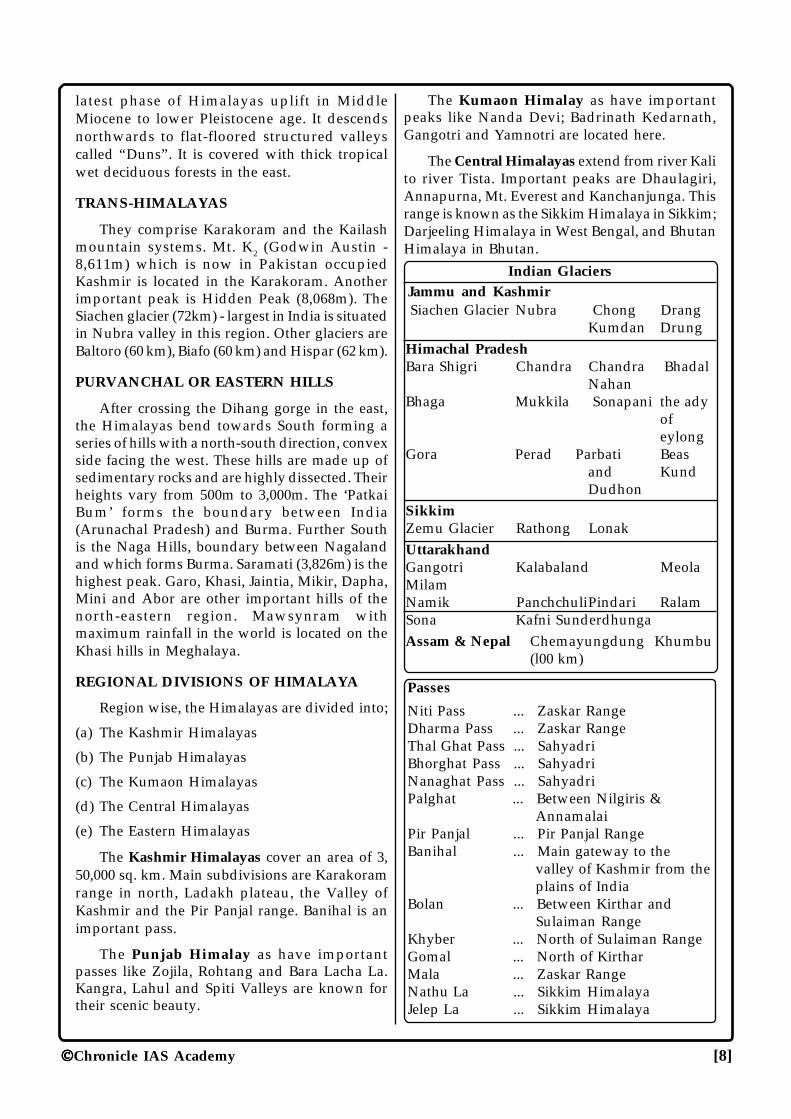
Indian GlaciersJammu and Kashmir Siachen Glacier Nubra Chong Drang
Kumdan DrungHimachal PradeshBara Shigri Chandra Chandra Bhadal
NahanBhaga Mukkila Sonapani the ady
ofeylong
Gora Perad Parbati Beasand KundDudhon
SikkimZemu Glacier Rathong LonakUttarakhandGangotri Kalabaland MeolaMilamNamik PanchchuliPindari RalamSona Kafni SunderdhungaAssam & Nepal Chemayungdung Khumbu
(l00 km)
Passes
Niti Pass ... Zaskar RangeDharma Pass ... Zaskar RangeThal Ghat Pass ... SahyadriBhorghat Pass ... SahyadriNanaghat Pass ... SahyadriPalghat ... Between Nilgiris &
AnnamalaiPir Panjal ... Pir Panjal RangeBanihal ... Main gateway to the
valley of Kashmir from theplains of India
Bolan ... Between Kirthar andSulaiman Range
Khyber ... North of Sulaiman RangeGomal ... North of KirtharMala ... Zaskar RangeNathu La ... Sikkim HimalayaJelep La ... Sikkim Himalaya
Chronicle IAS Academy [9]
Great Northern Plains
The great plains are an aggradational surfaceof great extent formed after the Himalayas. Theseare formed by the Indus, the Ganga andBrahmaputra rivers. The Great Plains stretch inthe east-west direction between the Himalayasin the north and the peninsular plateau in thesouth. Width varies from 500 km in Punjab-Rajasthan to 200 km. in Bihar. It covers an area ofover 7 lakh sq. km. Important characteristicsinclude - Bhabar (unsorted sediments), Terai(Marshy tract) Bhangar (older alluvium) andKhadar (newer alluvium)
The Great Northern plains consist of thefollowing regions:
(a) The Punjab-Haryana Plains: They aredrained by the tributaries of river Indus, Ravi,Beas and Satluj. These plains are flat with anaverage elevation of 200 to 240 metres. Thesefertile plains include the Bari Doab (between Raviand Beas rivers) and Bist Doab (between Beas andSatluj)
(b) The Rajasthan Plains: They cover an areaof 1.75 lakh sq. km. in Rajasthan and its adjoiningstates. It includes the Marusthali of Thar desertand bagar tract west of the Aravallis. The regionis one of the dry river beds (Saraswati) andshifting sand dunes. River Luni is an inlanddrainage river. Sambhar, Kuchaman, Didwanaand Pachbhadra are the salt lakes of this region.
(c) The Ganga Plains : The Ganga plains ofU.P., Bihar and West Bengal occupy an area of3.57 lakh sq. km. Important rivers of this regionare the Ganga, the Yamuna, the Gandak, the Sonand the Kosi. The Bengal basin is mainlycomposed of the Ganga delta.
(d)The Brahmaputra Plains: It containsalluvial deposits of the Brahmaputra and itstributaries the Subansiri, Dibang and the Lohit.It is a flood prone area because the slope of thevalley is too gentle to drain away the large volumeof rainfall in monsoon season.
Peninsular Plateau
The Peninsular plateau, which covers an areaof about 16 lakh sq. km., is the largestphysiographic division of the country. It hassenile topographical features. The Aravallis form
its boundary in the north-west, Rajmahal Hills inthe north and north-east. South of about 220Nlatitude, the Sahyadris (Western Ghats) and theEastern Ghats form the western and easternboundaries respectively.
On the basis of variation in relief, furtherdivisions of the Peninsular Plateau may be madeas follows:
(a) The Aravalli Range: It is one of the oldestfold mountains of the world. The highest peak isGurushikhar (1,722m) in Mount Abu Hills. TheDelhi Ridge marks the northern end of the range.
(b) The Central Plateau: It consists of Plateauof Rajasthan and Madhya Pradesh. Averageheight is 250-300m. The Malwa Plateau inMadhya Pradesh lies in the north of Vindhyas.The Plateau is largely broken. The Chambalravine is an important feature. The area betweenthe Yamuna and Vindhyan Plateau is calledBundelkhand Plateau. It lies in the east of Maikalranges and south of river Son. Important riversof the region are the Rihand and Son.
(c) The Vindhya Range: It is an escarpmentrunning in east-west direction. Kaimur Hills formits eastern portion.
(d) The Satpura Range: It lies betweenNarmada and Tapti (Tapi) valleys latitudinally.The plateau is formed of lava. The highest pointof Satpura range is Dhupgarh in Panchmarhi(1,350m). The eastern part of the range is MaikalPlateau.
(e) The Eastern Plateau and the ChhotanagpurPlateau: East of the Maikal Hills lies theBaghelkhand Plateau. South of the Baghelkhandis Chhattisgarh Basin. Further south is BastarPlateau or Dandakaranya.
The Chotanagpur Plateau lies in the east ofBaghelkhand Plateau. It has an average height of700m. It has a radial drainage. The Damodar riveroriginates near Tori in Palamau. Damodar valleyproject is located here. The Chotanagpur Plateauends in Rajmahal Hills.
(f) The Kathiawar and Kutch Peninsula:They have an Archaean structure but are surfacedby tertiary rocks. It tapers into the Arabian Sea.
(g) The Deccan Plateau: It is located withinthe Satpura-Mahadeo-Maikal ranges in the north,the Eastern Ghats in the East and the Western
Chronicle IAS Academy [10]
Ghats in the west. It is slightly titled towardssouth-east. The peninsula is triangular in shape-rising from 500 to 1,000m. Amarkantak (1,057m)and Dhupgarh (1,350m) are important peaks.
(h) The Western Ghats or the Sahyadris:They form the western edge of the DeccanPlateau. Starting from Khandesh, south of Tapiand running southward parallel along thewestern coast for 1600 km, it reachesKanyakumari and joins the Eastern Ghats atNilgiri Hills. Kalsubai (1,646m), Mahabaleshwar(1,438m) and Harishchandra are among thehighest peaks in this part of the ghats. Thalghatand Bhorghat are important passes throughwhich roads and railways run between theDeccan Plateau and the Konkan plains.Kudremukh (1,894m), Pushpagiri (1,714m) andBrahmagiri peak lie south of Coorg.
The highest peak of the Nilgiri Hills isDodabeta (2,637m) situated near Ootacamund.Udyogmandal (Ooty) is an important hill resort.
(I) Palghat Gap: It connects Tamil Nadu andKerala and is located south of the Nilgiri,separating the Cardamom Hills from the Nilgiris.Further south of the Palghat Gap, there are theAnnamalai Hills and the Palni Hills in the northeast. The culmination point of these hills is theAnai Mudi Peak (2,695m) with the distinction ofbeing the highest peak of South India.
(J) The Eastern Ghats: They form the easternboundary of the Deccan Plateau. They are brokenas compared to the Western Ghats. The highestpoint (1,680m) is in the Visakhapatnam district,Mahendragiri (1,501m).
The most important hill in the CuddapahRange is Nallamalla Hills. The Southern part ofNallamalla is called Palkonda Range. Javadi Hillsin North Arcot and Ginjee Hills in South Arcotand Pachaimalai in Tamil Nadu, form the othershills of the Eastern Ghat.
Coastal Plains
It occurs along the shores of the Bay of Bengaland the Arabian Sea. The Plains are narroweralong the west coast than the east coast. A numberof deltas occur on the east coast because thegradient is less steep.
1. The West Coastal Plains: It spreads itsstructure from the Rann of Kutch to Kanyakumari
for about 1,500 km. The Gujarat plain is formedby the Sabarmati, Mahi and several other rivers.The Karnataka coast extends south of Goa forabout 525 km. The Sharavati is an important river.The region has several rocky cliffs. The Keralaplain extends from south of Cannanore to CapeComorin for about 500 km.
2. The East Coastal Plains: Extends from themouth of Subarnarekha to Kanyakumari for about1,100 km. Its average width is 120 km. The EastCoast is much wider and contains many deltas.The Krishna and Godavari form large delta.Kolleru Lake is located between Krishna andGodavari. The Pulicat Lake is a lagoon (salt waterlake) separated from the sea by Sriharikota Island.The Utkal plains include the Mahanadi delta.Chilka Lake, south of Mahanadi delta is animportant Lagoon.
The Islands
India has in all 247 islands of which 204 lie inthe Bay of Bengal and remaining in the ArabianSea and Gulf of Mannar between India and SriLanka.
The Andaman and Nicobar are two majorgroups of Islands in the Bay of Bengal. These areextensions of the Arakan Yoma of Burma.
The islands in the Arabian Sea have a coralorigin and are surrounded by fringing reefs.Lakshadweep (32 sq. km. area) is important forcoral reefs. Further south of it is Minicoy islands.It is the largest with an area of 4.5 sq. km.Rameshwaram Island which lies just off the TamilNadu coast, between India and Sri Lanka, is alsoof coral origin.
Lakes
Lakes in India are mainly found inmountainous or coastal regions. The plains havefew lakes. On the basis of their origin they can beclassified as under:
(1) Tectonic lakes- Wular lake (Kashmir),Kumayun Lake
(2) Lakes formed due to volcanic activity-Lunar Lake (Maharashtra)
(3) Lagoon lakes- Chilka (Orissa), Pulicat (TamilNadu), Kolleru (Andhra Pradesh).
Chronicle IAS Academy [11]
(4) Glacial lakes- Khurpa Taal, Samtaal,Punataal, Malwa Taal, Nainital, Rakas Taal,Bhimtal (all Kuma yun Himalayas)
(5) Lakes formed due to Aeolian process-Sambhar, Pachbhadra, Lunakransar,Didwana (Rajasthan)
(6) Others- Dal lake (Kashmir), Udai Sagar,Pichola, Rajsamand, Jaisamand, Annasagar(Rajasthan), Loktak (Manipur) , Vembanad(Kerala), Husain Sagar (Andhra Pradesh)
Wetlands: India has 16 wetlands. They areKolleru (A.P), Wular (J.K), Chilka (Orissa), Loktak(Manipur), Bhoj(M.P), Sambhar and Pichola(Rajasthan), Astamudi, Sasthamkitla (Kerala),Harike, Kanjali (Punjab), Ujni (Maharashtra),Renuka (U.P), Kabar (Bihar), Nabsarovar(Gujarat), Sukhna (Chandigarh).
Drainage System
Important Concepts
Tributary: A river or stream whichcontributes its water to a main river. For example,the Yamuna is the tributary of the Ganga.
Distributary: A branch or outlet which leavesa main river and does not rejoin it, carrying itswater to the sea or a lake.
Delta: A triangular shaped alluvial tract,formed at the mouth of a river. For instance thedelta of the Ganges is the largest delta in theworld.
Doab: The alluvial tract of land between twoadjacent rivers, e.g. the plain between the Gangesand the Yamuna.
Catchment Basin (Drainage Area): Theregion which drains all the river water that fallson it into a river or stream.
Breakwater: A barrier built into the sea inorder to break the force of the waves and thus toserve as a protection against them.
Estuary: The mouth of a river where tidaleffects are felt and where fresh water and seawater mix.
Drainage Patterns: River and its tributariesdrain an area, which is called a ‘river basin’. Itsboundary formed by the crest line of thesurrounding highland is the watershed of the basin.
A river system usually develops a patternwhich is related to the general structure of thebasin.
A dendritic pattern develops in a region madeof rocks which offer some resistance to erosionand which has a uniform structure. A trellisdrainage pattern develops in a region made upof alternate belts of hard and soft rocks all ofwhich dip in the same direction and which lie atright angles to the general slope, down which theriver flows. A radial pattern develops on a domeor volcanic cone.
Classification of Drainage System: Over 90%of India’s land surface drains into the Bay ofBengal and almost all the remaining area drainsinto the Arabian Sea. Only a very small area inRajasthan has an inland drainage.
Our river system can be classified into:
(a) The Himalayan River System
(b) The Peninsular River System
The Himalayan rivers fall into four broad groups:
1. Pre-Himalayan Rivers: Arun, Indus, Satlujand Brahmaputra.
2. Great-Himalayan Rivers: Ganga, Kali,Ghaghra, Gandak, Tista etc.
3. Lesser -Himalayan Rivers: Beas, Ravi,Chenab, Jhelum etc.
4. Siwalik Rivers: Hindan, Sonali etc.
The peninsular rivers fall into two categories,viz., the coastal rivers and the inland rivers. Theformer are comparatively small streams. Thewest-coast rivers are of great importance.Although only 3 percent of the areal extent of thebasins of India is drained by these rivers, as muchas 14 percent of the country’s water resources arecontained by them.
1. Rivers rising from the Western Ghats: theGodavari, the Krishna, the Cauvery, thePennar, the Palar, the Vaigai etc.
2. Rivers flowing into the Arabian Sea: TheNarmada, the Tapi, the Sharavati etc.
3. Rivers originating in the Vindhyas andSatpura but flowing north-east towardsGanga: The Chambal, the Betwa, theDamodar, the Son, the Ken etc. The
Chronicle IAS Academy [12]
Narmada and the Tapi flow in the faultcreated by them during the Himalayanuplift.
Points to Remember
1. India is the seventh largest country of theworld in area-wise, accounting for about2.4% of the total world area, and secondlargest population wise.
2. Called a sub-continent for it stands outprominent in the Asian continent.
3. North-south extent is 3214 km. and west-east is 2933 km.
4. Total length of land frontier is 15200 km.
5. Total length of coastline is 7516 km.
6. Total length of mainland coastline is 6100 km.
7. States having common boundaries withIndia are Pakistan, Afghanistan, China,Bhutan, Nepal, Myanmar and Bangladesh.
8. Tropic of cancer passes through the subcontinent almost midway.
9. The southernmost tip is Pygmalion point(Now known as Indira point) in GreatNicobar Islands.
10. The southernmost tip of the mainland is theCape of Camorin 8° north of Equator.
11. Prominent islands in the Bay of Bengal areAndaman (200) and Nicobar (19), Barren andNarcondam.
12. Prominent islands in the Arabian Sea areLakshadweep (Coral island), Minicoy andAminidvi.
13. Prominent island in the Gulf of Mannar isPamban.
14. The Gulf of Mannar and the Palk Straitseparate India from Sri Lanka.
15. The western coast is known as Malabar coast(mainly in Kerala) and Coromandal coast(mainly in Tamil Nadu and AndhraPradesh).
16. 82°30' East longitude is taken to be StandardMeridian of India. The local time determinedalong this meridian serves as the Indian
Standard Time for every place, in thecountry. It passes through near Naini(Allahabad).
17. In India, “Aravalli Range” is one of theoldest mountain ranges of the world.
18. The only active volcano of India is found inthe Andamans.
19. The islands in the Arabian Sea are of coralorigin.
20. The “Satpura Range” lies between“Narmada” and “Tapti” rivers.
21. The Andaman and Nicobar are believed tobe the extension of the “Arakan Yoma” ofBurma.
22. The river Damodar originates near “Tori”in Palamau.
23. The “Palghat Gap” connects Tamil Naduand Kerala and is located south of theNilgiri.
24. India is 4 times larger than Pakistan whichis second largest in the Asia. 12 times largerthan UK and 8 times larger than Japan.
25. The northern frontier of India is “15,200”kmlong and it has a coastline of 6,100 km.
26. The Gulf of Mannar and Palk Strait separateIndia from Srilanka.
27. Himalayas has been credited of having theworld’s 14th highest peaks ranging betweenthe “Jana” (7710 m) Everest (8848 m)Kanchanjunga (8,598 m), Dhaulagiri (8,127m), Nanga Parbat (8,126 m) and Nanda Devi(7,817 m)
28. The “Khyber Pass” is of “1000 m” and leadsform Peshawar to Kabul.
29. The Gomal Pass is of “1,525 m” and is animportant trade route.
30. The Bolan Pass is of “1.800 m” and liesbetween the Sulaiman and the “Kirthar”range.
31. The “Shipki Pass” leads from Punjab toTibet.
32. The Western Ghat is known as “Sahyadri”in Maharashtra. In Tamil Nadu, they formthe Nilgiri Hills.
Chronicle IAS Academy [13]
33. “Kaveri” river is known as the “Ganga ofthe south”
34. Lake “Chilka” in Orissa, Kolleru and“Pulicat” in Andhra Pradesh are among thelarge lakes found in eastern coastal plain.
35. “Andaman and Nicobar” is separated by adeep sea known as “Ten Degree Channel”since it coincides with 100 N latitudes.
36. “Lagoons” are Salt water lakes which areseparated from the Sea by the formation ofthe sand bars along the coast.
37. On April 10, 1991, India’s only volcanoerupted in Barren Island in the Andamansafter lying dormant for 200 years.
38. Jammu town stands on the Jammu Hills ofSiwalik range of South Kashmir Himalayas.
39. Pir Panjal range of Himachal section ofKashmir Himalayas is the origin of thrustfaulting and isoclinal folding and istransversed by two passes - the Pir Panjaland Banihal; the later now provides the maingateway to the vale of Kashmir from theIndian Plains.
40. The vale of Kashmir is a synclinal valley,once the bed of a great lake. Kashmir valleyis very fertile with capital Srinagar in theheart and several beauty spots like Gulmarg.
41. Dal Lake near Srinagar was carved out ofthe alluvial deposits of Jhelum.
42. Deosai Basin of Kashmir is an example ofancient cirque lake.
43. Zojila pass of Kashmir Himadri connects theonly road to Leh (the capital of Ladakh) fromSrinagar.
44. Aksai Chin and Soda plains of LadakhPlateau are evidences of past glacial actionand are dry & bare.
45. Kangra Valley of Punjab Himalayas lies inits potential mineral oil wealth gone.
46. Badrinath, a religious place of Hindu lies inthe Himadri range of Kumaon Himalayas.
47. Jelep La pass of Sikkim Himalayas is themain route between Sikkim and the ChumbiValley.
48. Darjeeling Range is famous for tea gardens,especially on Tiger Hills.
49. Cherrapunji Plateau of Khasi Hills is anexample of Structural Platforms in India.
50. Dapha Bum is the highest peak of MishmiHills of Purva - NEFA.
51. Patkai Bum Range forms the watershedbetween India and Myanmar.
52. Saramati is the highest peak of Naga range.
53. Central part of the Manipur Hills is a largebasin which appears to be the bed of oldlake; a remnant of which occupies the south-east corner of the basin and is known as the“Loktak Lake”.
54. Southernmost part of the north-eastern rangeis known as Lushai Hills.
55. It is the ascending monsoon clouds over thefrontal slopes and the side valleys that havemade Cherrapunji world famous for rain.
56. Nokrek is the highest peak of Garo Hills ofMeghalaya plateau.
57. Kazi range, on the northern margin of theMikir Hills of Meghalaya plateau, has beendeveloped as a sanctuary for wild animals.
58. Most of the great Northern Plains arecomposed of alluvium deposits duringMiddle Pleistocene and recent geologicaltime.
59. Almost whole of the Western Arid Plain wasunder sea from the Permo-Carboniferous tothe Pleistocene time. It was uplifted duringthe Pleistocene time.
60. Western part of Western Arid Plain is sandyand is covered with shifting sand dunescalled “DHARIAN”.
61. Eastern part of Western Arid Plain, betweenthe desert and the Aravalli is a fertile tractscalled “ROHI”.
62. Flat, narrow strips of low lying flood plainsof Punjab Plains is known as “BETS”, whichhave been formed by the shifting of rivercourses.
63. The Punjab Plain is drained by many riversand the area between the two rivers arecalled DOABS such as :-
Chronicle IAS Academy [14]
(i) Bist Doab - between Beas and Satluj
(ii) Bari Doab - between Beas and Ravi
(iii)Rachna Doab - between Ravi and Chenab
(iv) Chaj Doab - between Chenab and Jhelum
64. The broad Punjab flood plains of Khadar,flanked by Bluffs are locally called as“DHAYA”.
65. In the north Bihar Plain, north of Ganga, along line of marshes are known as“CHAURS”, like Kabar Tal.
66. In the South Bihar Plain, South of Ganga &west of Rajmahal hills, on the outward sideoccur vast depressions, known as “JALA”near Patna and “TALA” near Mokama.
67. North Bengal Plains, from the foot of EasternHimalayas in the north to the northern limitof Bengal basin, is the ideal home of teaplantation. Further south lies the older deltaof the Ganga formed during the Pleistocenetime and subsequently upwarped anderoded into terraces known as “BARINDPLAIN”.
68. “RAHR PLAIN” is the low land to the westof the Bhagirathi and when the rivers likeDamodar are in flood, the entire countrysideis submerged.
69. Due to hard quartzite rocks the Aravalliprovides unfavourable environment formen.
70. Narmada river from a spring onAmarkantak Plateau and at Bheraghat. Itforms a waterfall known as Dhuandhar orMarble fall.
71. Palghat Gap, in the Western Ghats, is 24km. wide and is probably a rift valley, owingits existence to subsidence of the landbetween two parallel fault lines. Ponnaniriver flows through it.
72. Palni Hills, the continuity of SouthernSahyadri in the north-east direction, hasmany beauty spots like Kodaikanal.
73. The Cardamom Hills or Elamalai, south ofPalghat Gap as the continuation of SouthSahyadri, is famous for cardamom
plantation. Its east face is densely populated,commonly known as Kambam Valley.
74. South of Tapi Valley in Maharashtra Plateauis the Ajanta Range and a southern spur,Ellora Hills is equally famous for its caves.
75. Physigoraphically, the Mysore Plateau canbe subdivided into two parts:
i) Malnad - Hilly, deep valley, densely forested; Baba Budan hill lies here &
ii) Maidan - Rolling plains with low granitic hills.
76. Eastern Ghats in Orissa and Andhra Pradeshis locally known as MALIYAS (highland),forming watershed between west flowingstreams like Machkund, Sileru and the eastflowing streams like Vamsadhara.
77. In Tamil Nadu and Andhra Pradesh the EastCoast Plain is also called PAYAN GHAT,extending from Cape Comorin to Krishna-Godavari delta.
78. Bhargavi and Daya rivers drain into ChilkaLake.
79. Kutch and Kathiawar peninsula, on thenorthern end were once islands.
80. Vaitarna and Ulhas rivers drain the Konkancoast region.
81. Sharavati river drains the Karnataka coastwith making the famous waterfall,“Gersoppa fall”.
82. Astamudi and Vembanad lakes are situatedon the Kerala coast.
83. Arabian sea and the Bay of Bengal came intoexistence during the late Cretaceous or EarlyTertiary time.
84. South of Kathiawar the continental shelf is350 km wide and 220 km. wide south of themouth of Ganga. Elsewhere its width rangesfrom 50 km on the east coast to 100 km. onthe West Coast.
85. Bay of Bengal Islands are the elevatedportion of submarine mountain range whilethe Arabian sea islands are of coral origin.
86. Barren Island and Narcondam Island are theonly volcanic islands within IndianTerritory.
Chronicle IAS Academy [15]
87. Little Andaman is separated from the GreatAndaman by the “Duncan Passage”.
88. South Andaman consists of parallel ridgesand valleys with the highest hills “Mt.Harriet” (450 m), facing the east coast. Thecity Port Blair lies here.
89. Off the west coast of the North and MiddleAndamans there are a number of smallerislands like Interview and Anderson,composed of limestone.
90. Nicobar Islands is a group of 19 islands butonly 12 are inhabited.
91. Within the Nicobar Islands Great Nicobar isthe largest and the Car-Nicobar is thenorthernmost island.
92. Main islands of Nicobar group are - LittleNicobar, Katchall, Camorta, Trinket,Nancowry etc.
93. Barren Island is a dormant volcano whilethe Narcondam Island is an extinct volcano.
94. Coral Island in the Arabian Sea is situatedbetween 8 Degree N and 12 Degree N.
95. Amindivi Island is a group of six Islands-Amini, Kilton, Chetlat, Kadmat, Bitra andPeremulpur.
96. Laccadives Islands is a group of five islands-Androth, Kalpeni, Kavaratti, Pitti and SuheliPar.
97. Among the Arabian sea islands the MinicoyIsland is the Southernmost, in the 8 Degreechannel.
Various Ganga Rivers
Ram Ganga ... Originates from DudatoliMountain (Nainital) joinsGanga below Farukkhabad.
Vishnu Ganga ... Originates from Kamet nearMana pass. Together withDhauli forms Alaknanda(one of the two streamswhich from the Ganga) atVishnuprayag.
Ban Ganga ... A bifurcation channel of theGanga after Haridwar jointhe main channel of theGanga at Majllispur.
Kali Ganga ... Originates from Milam Gla-cier, known as Sarju in itslater course.
Wain Ganga ... A tributary of GodavariPen Ganga ... A tributary of GodavariPanch Ganga ... A tributary of the Krishna
RiverDudh Ganga ... A tributary of the Krishna
RiverVridha Ganga ... Another name of GodavariDakshin Ganga ... Another name of Godavari Kishan Ganga ... Originates from Pir Panjal
Range; Joins the Jhelum
Hot Springs
Phunknag ... J&KMani Kama ... HimachalRajgir ... BiharTapowan ... JharkhandTatapani ... Shimla (HP)Vaireswari ... Thana Dist., MaharashtraBakreswar ... Virbhum (W.B.)Bhayumtan ... Sikkim
���
Chronicle IAS Academy [16]
The climate of India is broadly, of the tropicalmonsoon type. The word monsoon (Arabic:Mausim) stands for seasonal reversal in the windpattern and accounts for and is associated withthe rhythm of season, changes in the direction ofwinds, distribution pattern of rainfall andtemperature with the change of seasons.However, the regional variations in climate can’tbe ignored. These variations are expressed interms of winds, rainfall, temperature andhumidity. Main factors deciding the local climateare location, altitude and distance from generalrelief.
Mechanism of Indian weather
India has wide regional variations in termsof winds, rainfall, temperature, humidity etc.These differences in local climate are producedby the following factors:
I. Surface distribution of pressure and winds;
II. Upper air circulation caused by factorscontrolling global weather and the inflowof different air masses and jet streams; and
III. Inflow of western disturbances and tropicaldepressions into India creating weatherphenomena leading to rainfall.
Seasons
On the basis of monsoonal variation, there arefour seasons in India.
(a) The Cold Weather Season: (December toFebruary): Mainly felt in North India - animportant event of the season is the inflow of thedepression from the west to the north-west. Theselow pressure systems, called Westerndisturbances, originate in West Asia and traveltowards India causing some rain and snowfall inwinter months in north and north-eastern India.
The temperature increases from north tosouth. The isotherms run parallel to the latitudes.
CLIMACLIMACLIMACLIMACLIMATE OF INDIATE OF INDIATE OF INDIATE OF INDIATE OF INDIA CHRONICLEIAS ACADEMYA CIVIL SERVICES CHRONICLE INITIATIVE
20° isotherm runs east-west through the middlepart of India. By the mid-December in the north-west India a series of shallow cyclonicdisturbances is observed. The rainfall is mostlyconfined to Punjab & Haryana Plains, North-eastRajasthan, Kashmir and western U.P. In northernIndia it is very useful for Rabi crops.
(b) The Hot Weather Season (March to May):Because of the heating of the subcontinent, theequatorial trough moves northward and lies at25°N in July. This trough attracts surface windsfrom South - Westerly direction along the WestCoast and from north, north - Westerly directionalong the Bengal Coast. The northward shift ofequatorial trough and the excessive heating of theHimalayan and the central Asian highlands areresponsible for generating the monsoon, theinflux of monsoon in mid - June changes theseason to the rainy one.
Tornado-like dust storm of Punjab andHaryana; the “Andhis” of U.P. and the“Kalbaishakhis” of West Bengal involving strongconvection movements causes some precipitation.The “Norwesters” (Kalbaishakhis of West Bengal)originate over the Chotanagpur Plateaus andblow in the north east direction which bring about50cm of rainfall in Assam and about 10cm rainfallin West Bengal and Orissa. This rainfall is veryuseful for Assam Tea and spring rice crops ofWest Bengal.
Similar thunderstorm causes about 25cmrainfall in Karnataka which is locally called as“Cherry Blossom”, beneficial to the coffeeplantation and “Mango Showers” elsewhere inSouth India, which are of salutary effect on themango crop. “Loo”, a hot wind blows in thenorthern plain during May and June, with thetemperature range of 45°C to 50°C.
(c) The South - West Monsoon Season (Juneto September): The ‘monsoon burst’ brings aboutthe sudden onset of rain on different dates indifferent parts of India. The Arabian Sea current
Chronicle IAS Academy [17]
covers West Coast, Maharashtra, Gujarat andparts of Madhya Pradesh, whereas the Bay ofBengal current strikes the Bengal coast and theShillong plateau and moves West and north -west, parallel to the Himalayas and brings rainto Bihar, U.P., Delhi etc. The two currents mergeover Punjab. The tropical depressions, whichperiodically occur, cause dry spells during themonsoon season. So these depressions determinethe amount of rainfall The East Coast of Indiaremains dry during this season of June -September, since it is in the rain shadow area ofthe western current and is parallel to the Bengalcurrent.
The normal date of onset of the S.W. -Monsoon is 20th May in Andaman and NicobarIsland, 1st June on Kerala coast and by 15th Julyit covers whole of India. The withdrawal ofmonsoon is much more gradual process than itsonset. Normally it withdraws from north-westIndia by the beginning of October and fromremaining part of India by the beginning ofDecember. Out of the total moisture brought bythe monsoon, only 20 percent is precipitated inIndia.
Arabian Sea branch causes the first monsoon-burst over the Kerala coast normally by 5th Juneand later on causes heavy rain along the westerncoast, while the large part of Deccan lies in a rainshadow of the Western Ghats and receivedecreasing amount of rainfall. The Arabian Seabranch does not brings much rain to Gujarat andRajasthan mainly due to absence of a mountainbarrier, but gives moderate to heavy rainfall inthe foothills of Western Himalayas, EasternPunjab and North-eastern Rajasthan. The ArabianSea branch is much more powerful than the Bayof Bengal branch.
The Bay of Bengal branch after crossing thedeltaic region enters the Khasi Valley andentrapped within it due to funnel shape of theregion and strikes Cherrapunji in a perpendiculardirection causing heaviest rainfall near“Mawsynram” (1143cm). A series of depressionare originated at the head of Bay of Bengal andtravel in a north westerly direction across centraland northern India causes heavy rainfall alongtheir tracks, with the frequency of 2 to 4depressions per month from June to September.
(d) The North - East Monsoon (October toDecember): The retreat of South-West monsoonfrom North India starts in September and isgradual. During this season, severe cyclonicstorms develop in the Bay of Bengal which movesin a South-easterly to North-Westerly direction.They give substantial amount of rainfall to theEast coast and sometimes cause havoc in AndhraPradesh, Tamil Nadu and West Bengal. In TamilNadu and surrounding areas, it is known as thenorth east monsoon period.
Generally the withdrawal of monsoon startsfrom 1st September in the north-western Indiaand is completed in mid December from South-eastern coast of Tamil Nadu. With the migrationof Sun towards the south, a high pressure centrebegins to build up over the landmass and there isa gradual weakening and withdrawal ofmonsoon. The retreating monsoon causes rain inthe coastal tracts to the south of Krishna delta andthe interior of the southern districts.
Climatic Regions of India
The climatic division of India is based uponTrewartha’s scheme, which is a modified form ofKoppen’s system and it corresponds with thevegetative, agricultural and geographical regionsof India. Main climatic regions of India include:
(i) Tropical Rain Forest (Am): It is found onthe West coastal plain, the Western Ghats andsome parts of Assam. It is characterized by hightemperature in winter not below 18.2°C; and insummer about 29°C. The average rainfall exceeds200 cm.
(ii)Tropical Savanna (Aw): It is located inpeninsular region except the semi - arid zone inthe leeside of the Sahyadris. It is characterized bylong dry weather throughout winter and earlysummer and high temperature (above 18.2°C).Annual rainfall varies from 76 cm in the west to150 cm. in the east.
(iii) Tropical Semi-arid Steppe (BS): Prevailsin the rain-shadow belt running southward fromCentral Maharashtra to Tamil Nadu in the leesideof the Sahyadris and Cardamom Hills. It ischaracterized by low rainfall which varies from 38cm to 80 cm, high temperature between 20°- 30° C.
(iv) Tropical and Sub-Tropical Steppe (BSh):Occurs over Punjab extending to Kutch region.
Chronicle IAS Academy [18]
The Thar Desert is in the west and the morehumid climate of the Ganga plain and thePeninsula to its East and South respectively.
(v) Tropical Desert (BWh): The area includesthe western parts of Barmer, Jaisalmer andBikaner district of Rajasthan. A large portion ofKutch Peninsula along with Thar Desert is alsoincluded. It is characterized by scanty rainfall (30cm. average) with few parts receiving 12 cmannual rainfall. Temperature is above 35° C.
(vi) Humid Sub-tropical with Dry Winter(Cwa): The area includes South of the Himalayas,East of the tropical and sub - tropical steppe andnorth of tropical Savanna. It is characterized byrainfall of 63.5 cm to 254 cm most of which isreceived during the South West Monsoon season.
(vii) Mountain Climate (H): The area liesabove 6000 metre sea-level. Examples are theHimalayan and Karakoram ranges. Temperaturedecreases with altitude. The Trans - Himalayanregion particularly Ladakh has a dry and coldclimate - what may be called cold desert. Droughtis permanent.
Variability in the rainfall
The average annual rainfall in India is 100cm.However, this rainfall is neither uniformlydistributed throughout the country nor certain tooccur every year. The unpredictable nature of theannual rain poses a major problem for India. But,there are certain regions of heavy rainfall in Indiawhich are almost certain to get the annual rainfallof more than 200 cm every year. These are Assamand its neigh bourhood, the Western Ghats andthe adjoining coastal areas and foothills of theHimalayas. In contrast, certain areas, particularlywestern Rajasthan, Kutch, Ladakh Plateau areperpetually drought - prone, the average annualprecipitation being about 100 cm.
Points to remember
1. The position of mountain ranges and thedirection of the rain bearing winds are thetwo main factors that determine the climateof India.
2. The chief characteristic of India’s climate isthe alternating seasons.
3. “Growing Season” is that part of the yearwhen the growth of vegetation is madepossible by the favourable combination oftemperature and rainfall. The length of thegrowing season is determined by thenumber of frost free days.
4. The “North - East Trade Wind” blows fromthe continents to ocean.
5. In March, the highest day temperature ofabout “380C occurs in Deccan Plateau.
6. In March, Rajasthan has very hightemperature of “450C”.
7. In Kerala and Western coastal land, the pre-monsoon showers are known as “mango -shower”
8. “Kalbaishakhi”, which is accompanied bythunderstorm, strong wind and heavyrainfall, occurs in Assam and West Bengal.
9. “Loo” refers to hot, dry wind that blows innorthern plains. It is very common inHaryana, U.P, Punjab and Bihar.
10. During SW monsoon, the bulk of the rainfallis received in every part of India exceptTamilnadu.
11. It is the relief of the region which determinesthe amount of rainfall in any region.
12. The “South - East Trade Wind” from thesouthern hemisphere are drawn into Indiaas the south - west monsoon winds whichafter they cross the equator.
���
Chronicle IAS Academy [19]
SOILS OF INDIASOILS OF INDIASOILS OF INDIASOILS OF INDIASOILS OF INDIA CHRONICLEIAS ACADEMYA CIVIL SERVICES CHRONICLE INITIATIVE
Soils in India display wide diversity becauseof the variations in the climate and relief. The soil-forming components which include parentmaterial, relief, climate and natural vegetationvary spatially. The soil can be classified undervarious criteria, most acceptable being based onhorizon development and its relationship withclimatic condition.
The factors that affect the soil formation are:
1. Parent Material: The parent material, ofwhich the soils are formed, is derived from theweathering of the rocks exposed on surface. Forexample the soil derived from lava and rocks isgenerally black in colour.
2. Relief Features: They influence the processof soil formation through various ways. Thevariation in relief features like slope,underground water etc. affect the colour,composition and properties of soil.
3. Climate: Climate is the most importantsingle factor in soil formation. It affects theconditions of soil formation through the amountand seasonal distribution of temperature andrainfall. It also affects soil formation indirectly byaffecting other genetic factors like parent material,relief features, natural vegetation etc.
4. Natural Vegetation: The decayed leafmaterial adds to the fertility of soil by providingto it the much needed content of humus. That iswhy the densely forested areas contain some ofthe best soils.
Soil Types
The Indian Council of Agricultural Research(ICAR) has divided the Soils of India into 8 majorgroups.
1. Alluvial Soils including the coastal anddeltaic alluvium: Agriculturally the mostimportant soil. It covers 24% of the country’s totalarea. Mainly found in Central plains extendingfrom Punjab to Assam, Eastern and Western
Coastal plains and deltaic region. Alluvial soil istransported or inter-zonal soil. It is divided intoKhadar (newer) and Bhabar (older). This soil is,however, deficient in nitrogen and humuscontent; unsuitable for water retentive plantatione.g. cotton. It is suitable for the cultivation of rice,wheat, sugar cane and vegetables.
Khadar: Finer and newer alluvium. Its texturevaries from clayey to sandy loam. It is light incolour and is formed in the flood-plains of riversand is generally acidic, deficient in lime,phosphorus and humus.
Kankar: They are found only few feets belowthe surface of Bhangar which is a bed of limenodules known as kankar. Kankars are collectednear Dadri in Haryana for making cement.
Bhangar: They are older alluvium or coarsegravel, high level soils above 30 m above floodlevel where flood water cannot reach. Its textureis more clayey and the colour is darker.
Alluvial texture varies from sand and loamto silts and heavy clays that are ill drained andsometimes injurious accumulations of salt andproduces a sterile surface called “Usar”.
In the sub-mountain belts on the foot hills ofSiwalik alluvial forms with coarse often pebblysoils known as “Bhabhar”. To its south occursswampy lowland with silty soils known as“Terai”.
2. Black Cotton Soils: This is also called regursoil. Main areas include Deccan Trap,Maharashtra, Gujarat, Madhya Pradesh,Karnataka, Andhra Pradesh, Tamil Nadu, U.P.and Rajasthan. Black Soils are usually deficientin nitrogen, phosphate and humus but rich inPotash, lime, aluminum, calcium and magnesium.The soil is moisture retentive and it has a highdegree of fertility. It is suitable for the cultivationof cotton, cereals, oilseeds, tobacco, groundnutand citrus fruits.
Black soils develop under semi-aridcondition, in area covered with basalt. Colour of
Chronicle IAS Academy [20]
the black soils varies from deep black to lightblack or chestnut. The black colour is added dueto the presence of “Titaniferous magnetite”.
They become sticky when wet due to highpercentage of clay and develop cracks in hot-sunny weather. Black soils are well known fortheir fertility. Since, the content of water solublesalt is high they are not suitable for heavyirrigation. Black soil regions are ideal for dryforming due to their moisture retentive quality.
3. Red Soils: Occupies about 70% of the totalarea in Tamil Nadu, Chhotanagpur, few parts ofAndhra Pradesh and Orissa.
Red soils develop generally on crystalline andmetamorphic rocks rich in ferromagnesiumminerals. Hence they are more sandy and lessclayey. Red soils are found in area ofcomparatively low rainfall and so are less leachedthan the laterite soils. Red soils have aconcentration of iron, absence of lime, Kankar,carbonates, humus, phosphoric acid and areneutral to acid reactions.
They are not retentive to moisture socultivated mostly during the rainy season. Theseare favourable for the cultivation of pulses andcoarse grains.
Crops: Rice, Ragi, Tobacco, Vegetables,Groundnut etc. on coarse soil for higher level;Sugarcane on heavy clay at lower level.
4. Laterite Soils: They are formed under theconditions of high rainfall and temperature withalternate wet and dry periods. These soils are richin oxides of iron and aluminum but poor innitrogen, potash, phosphoric acid and limecontent due to leaching; highly acidic in nature.These soils are concentrated in Vindhyan Plateau,Satpura, Mahadeo and Maikal ranges in MadhyaPradesh, Malabar Coast, Orissa coast andMeghalaya.
Laterite soils develop in the tropical regionswhich receive heavy seasonal rainfall. Heavyrainfall promotes leaching whereby lime andsilica are leached away and soils rich in oxides ofiron and aluminum are left behind. If the oxideof aluminum predominates the laterite soils, theyare called “Bauxite”, the chief industrial ore ofaluminum.
Laterite soils are red due to the presence ofoxides of iron. They are poor in lime content hence
acidic in nature. Laterite soils of high areas arevery poor and least retentive to moisture.Sometimes they form the barren land topography.Laterite soils of low level areas hinder the processof laterization due to regular addition of soilwashed down from the neighbouring high areas.
Crops: Rice, Ragi, Sugarcane, Tapioca,Chestnut etc.
5. Forest Soils: Humus predominates in forestsoil but it is deficient in potash, phosphorous andlime. It is distributed over the Himalayan andother ranges in the north, Western Ghats, EasternGhats and Peninsula. Favourable for plantationcrops e.g. tea, coffee spices and tropical fruits.
1. Podzols (At high Level): They are formedunder high acidic condition and found onhigher slopes of Himachal Pradesh andJammu & Kashmir. They are covered byconiferous forests. They are highly leacheddue to excessive moisture and are greyishbrown in colour.
2. Brown Forest Soil (In warm temperate belt):They are less acidic than podzol with highbase status. They are rich in humus andfertile and extensively used for cropcultivation.
3. Alpine Meadow (In alpine zone ofHimalayas): They are dark coloured, eithersandy-clay or sandy-loam. They containmostly undecomposed plants.
6. Arid and Desert Soils: These soils,characterized by high salt and low humuscontent, are found in Rajasthan, Haryana, Punjab,Rann of Kutch, and other rain-shadow regions,since these soils consist of high phosphate,fertility increases with irrigation and by addingnutrients.
Desert soils are found in an arid and semi-arid conditions in north-western part of India,west of Aravalli range. They are mostly friableand low in moisture content. They are rich inphosphate but poor in nitrogen and clay content(only 8%).
Crops: Very few crops especially Millets,Jowar, Bajra are grown for want of water supply.
7. Saline and Alkali Soils: Develop along aridregion in small patches. Also called Reh, Kallarand Usar, they are infertile but can be reclaimed
Chronicle IAS Academy [21]
by good drainage. These soils are found inRajasthan, Punjab, Haryana, U.P. and Bihar.
Saline and alkaline soils develop at placeswhere desert condition prevails because of highrate of evaporation and very little leaching. Salinesoils contain free sodium and other salts whilealkaline soils have sodium chloride. Alkaline soilsare deficient in calcium and nitrogen and arehighly impervious and have very low waterholding capacity.
Crops: Rice, wheat, cotton, sugarcane, tobaccoetc. supported by irrigation. For better fertilityapplication of lime and gypsum and cultivationof salt resistant crops like berseem, rice, sugarcanecan be used.
8. Peaty and Organic Soils: Develop underresult of accumulation of large quantity of organicmatter. Highly saline and deficient in phosphateand potash and occur in central Orissa, CentralBihar, West Bengal and Tamil Nadu.
Peaty and Marshy soils originate in humidregions as a result of an accumulation of largeamount of organic matters. They may containconsiderable soluble salt and is called as “Kari”.
These areas are submerged under waterduring the monsoon season and as soon as rainceases the land is put under paddy cultivation.These soils are black, heavy and highly acidic.
Soil Erosion
The destruction of soil cover is known as soilerosion. The main reasons of soil erosion are:
(a) Deforestation
(b) Over-grazing
(c) Irrational cultivation (e.g., Jhoomcultivation in North Eastern India)
(d) Floods
(e) Winds
Soil Erosion in India: The areas which havesuffered soil erosion in India are generally tractshaving sparse vegetation cover like the badlandsof lower Chambal and the Yamuna. The
vegetation cover in these areas is sparse; hence,the running water cuts easily into the soil formingdeep ravines. In many parts of the plain a highdegree of slope induces similar erosion. The dryareas of Rajasthan and Haryana, on the otherhand, lose their soil cover through wind erosion.
Soil Conservation: Soil conservation dependson the existing conditions. The most commonmethods, however, include afforestation, contourcultivation and scientific methods of cultivationkeeping in view landform characteristics.
Rain water washes the calcium compoundsand consequently it causes the lime deficiency insoils. Such soils are acidic and develop in area ofheavy rainfall. Oxygen combining with ironcompounds produces Iron-Oxide, red in colourand it gives the red colour to the soils.
Points to remember
1. Chemical weathering is more important inhot tropical climate. Hence, the Indiansubcontinent is prone to chemical weathering.
2. Leaching is more important in area of heavyrainfall. It is the most common feature ofhilly regions.
3. High temperature of India promotes activedecay of vegetation and hence humus isdestroyed. So, Indian soils are generallydeficient in humus and require regularapplication of nitrogen rich fertilizer.
4. Titanium salt adds black colour to the soilsof Indian Plateau.
5. Sedentary soil / in situ soil, produced afterbreaking of parent rocks underneath thesurface, are usually very deep up to 15mt.or more on the Deccan Plateau.
6. Sedentary soils are: Black cotton soils,Laterite Red soil, Podzolic soil of forest,Saline and Alkaline soil, Peaty soil.
7. Drifted soils / Transported soils / Azonalsoils are formed in situ but transported byagents and deposited in valleys and deltas.
���
Chronicle IAS Academy [22]
NNNNNAAAAATURALTURALTURALTURALTURAL
VEGETVEGETVEGETVEGETVEGETAAAAATIONTIONTIONTIONTION
CHRONICLEIAS ACADEMYA CIVIL SERVICES CHRONICLE INITIATIVE
Natural vegetation may be defined as that partof plant communities which has been remainingundisturbed over a long period of time. Here theindividual species adopt them selves to certainsoil and climatic conditions and proliferatethough natural process.
On the basis of appearance of the plantcommunity with respect to form and othercharacteristics, the vegetation of India iscommonly identified as forest, grasslands andshrubs. The climate, specially the sun shine andprecipitation, deter mines the type of plant speciesthat can survive in a particu lar region.
On the basis of climatic condition, thevegetation has been classified as: - TropicalEvergreen forests, Monsoon forests, TemperateForests, Grasslands, Tundra, Savanna, Prairie,Alpine and so on.
Basic terms:
� Flora: It refers to the plants of a particularregion or period, listed by species andconsidered as a group.
� Vegetation: It refers to the assemblageof plant species living in association witheach other in a given environment -often termed ecological frame.
� Forests: Forest is a large tract covered bytrees and shrubs. It consists of forests,grassland and scrub.
Forest Area
Forests constitute about 23% of India’s totalland surface and occupy 746 lakh hectares of land.The Chhattisgarh and MP covers 7217 hectare,Arunachal Pradesh 5110 hectares, Orissa - 2857hec, Andhra Pradesh- 2724 hec, Maharashtra-2724 hec and Uttaranchal - 1887 hectares.
Major Vegetation Regions
1. Tropical Evergreen or Rain Forests: Theseforests occur in areas where the rainfall exceeds
200 cm, the average annual temperature isbetween 20°C to 27°C and average annualhumidity exceeds 77 per cent. The trees areevergreen and dense and forests have a threestoried appearance. These forests are found inWestern parts of Western Ghats, eastern part ofsubtropical Himalayas (Terai), north east Indiacomprising Lushai, Cachar, Khasi, Jaintia andGaro hills and most of Andaman and NicobarIslands.
These forests may be sub divided into thefollowing sub-types:
(i) Tropical Wet Evergreen Forests: Theycover 4.5 m. ha area and are found along thewestern side of the Western Ghats, in a striprunning south-west from Arunachal Pradesh,upper Assam, Meghalaya, Nagaland, Manipur,Tripura and Andaman and Nicobar Islands. Herethe rainfall exceeds 300 cm. The forests are lofty,dense, evergreen and multistoried.
The main species of trees found are Poon,toon, chaplas, rosewood, ebony, Sissoo,ironwood, Gurjan, pila champa etc. Theundergrowth consists of canes, bamboo, ferns,climbers etc. Due to the dense undergrowth andlack of transport these forests have not beenexploited.
(ii) Tropical Semi-evergreen Forests: Wherethe rainfall is somewhat less than 200 cm, themean annual temperature between 24°C to 27°Cand humidity percentage is 80, the evergreenforests degenerate into semi-evergreen forests.These cover 1.9 m. ha area. These forests are foundon the western coast, in upper Assam, lowerslopes of eastern Himalayas, Orissa and inAndaman and Nicobar islands. The forests haveevergreen trees mixed with deciduous types. Theimportant species include Aini, Semul, Kadam,irul etc.
(ii) Tropical Moist Deciduous Forests: Suchforests occur in areas of low annual rainfall of 100cm to 150 cm. The main annual temperature isbetween 26°C to 27°C, and humidity percent is60 to 80. These forests are found in a belt running
Chronicle IAS Academy [23]
north-south on eastern slopes of western ghat,central plateau including Chotanagpur, UpperMahanadi Valley and hills of Madhya Pradesh,Himalayan foothills, eastern ghats in Tamil Naduand Andaman and Nicobar islands.
These forest trees shed their leaves and are themost important forests source of commercialtimber. The species of trees include Sal, teak,Arjun, jarul, laurel, Andaman paduk, ebony,mulberry, Kusum, kanju, ber, gular, palas, haldu,siris, mahua, Semul, har, sandalwood, jamun etc.Most of these forests have been cleared from levelland for cultivation.
(iv) Littoral and Swamp Forests: These forestscover 6 lakh ha and occur in and around tidalcreeks and river deltas. They are found in thicketson western coast at a few places but on the easterncoast they form a continuous belt on the fringe ofdeltas of Ganga, Mahanadi, Godavari, Krishnaand Cauvery. They are densest in Sunderbans,where Sundri trees predominate.
2. Dry Tropical Forests: These forests occurin areas having annual rainfall between 75 cm to125 cm, mean annual temperature of around 23°Cto 27°C and humidity between 51 to 58 per cent.They are divided into the following sub-types.
(i) Tropical Dry Deciduous: These forests arefound on a very large area in an irregular widestrip running north south from the foothills ofHimalayas to Kanyakumari except in Rajasthan,Western Ghats and West Bengal. The importanttrees include teak, tendu, sal, bijasal, rosewood,palas, bel, lendi, axlewood, anjair, harra, khair etc.
(ii) Tropical Thorn Forests: They arerestricted to areas where rainfall is very low i.e.between 50 cm to 75 cm, the mean annualtemperature is between 25°C to 27°C andhumidity is less than 47 per cent. They are foundin Kutch, neighbouring parts of Saurashtra, alarge strip in south western Punjab, westernHaryana, western and northern Rajasthan, UpperGanga plains, Deccan plateau and lowerpeninsular India. Here thorny trees especiallyacacias predominate.
(iii) Tropical Dry Evergreen Forests: Theseforests occur in areas where the mean annualrainfall is about 100 cm, mean annual temperatureis about 28°C and mean annual humidity is 74per cent. These forests are found in the east coastof the peninsula. The important species of treesinclude khirni, jamun, kokko, ritha, neem, palm, etc.
3. Riparian Forests: Where the rainfall is lessthan 50 cm, short trees and grass predominate.These forests are found along banks of rivers andwet lands. Deciduous vegetation like neem,Shisham, pipal, mango, jamun, khair are usuallyfound. Kans and munj grass are found inabundance.
4. Subtropical Broad Leaved Hill Forests:The forests are found between 915 to 1830 mheight above sea level where the mean annualrainfall is between 75 cm to 125 cm, mean annualtemperature is between 18°C to 21°C andhumidity percent is 80. These forests are foundin high lands of Bastar, Panchmarhi,Mahabaleshwar, Nilgiris, Palni and Khasi hillsand lower slopes of Himalaya in West Bengal andAssam. Such forests are called ‘Shola’ in SouthIndia.
5. Montane Wet Temperate Forests: Theseforest occur at a height of 1800 to 3000 m abovesea level in areas where annual rainfall is between150 to 300 cm, annual temperature is between11°C to 14°C and humidity per cent is 83. Theseforests are found in hills of Tamilnadu, Kerala,Eastern Himalayas, higher hills of West Bengal,Assam and Arunachal Pradesh. The main treesfound are deodar, Indian Chestnut, magnolia,birch, plum, blue pine, oak, hemlock etc.
6. Montane Moist Temperate Forests: Theyoccur in temperate eastern and westernHimalayas between the pine and alpine forestsin Kashmir, Himachal Pradesh, Punjab, UttarPradesh, Darjeeling and Sikkim between 1600 to3500 meters. The forests are predominantlyconiferous forests and include trees like pine,deodar, spruce, silver fir, oak, beach, birch, polar,elm, chestnut, maple, rhododendrons etc.
7. Alpine Forests: They occur in the Alpineareas of the Himalayas beyond the limit of treegrowth i.e. between 2900 to 3500 m and consist ofdwarf shrubs of juniper, fir, honey suckle, birch,rhododendrons etc. At still higher altitudes,shrubs of low herbs are the only vegetation found.
8. Grasslands: These grasslands are dividedinto three types (i) Hilly or upland grassland.They are found in Himalayas above 100 m and inDeccan hills (ii) low land grasslands - They occurin plains of Punjab, Haryana, Uttar Pradesh, Biharand north western parts of Assam (iii) Riverine
Chronicle IAS Academy [24]
grasslands. They are found in riverine tracks ofnorthern India especially in the bhabhar tracks.
Points to Remember
1. The total forest cover in India is “6, 37,397”sq hectare which constitutes about“19.39”percent of the total geographic areaand the per capital forest in India is 0.2hectares.
2. Area wise, at present, Arunachal Pradeshhas the highest coverage of forest, earlier itwas M.P.
3. Among the Union territory, Andaman andNicobar has the largest area under forest.
4. As far as the “mangrove” forest is concerned,“West Bengal” holds the first positionfollowed by Gujarat and Andaman Nicobar.
5. The tropical “Moist Deciduous Forestrequires annual rainfall of 200 cm meanannual temperature of 260 - 270C.
6. The Wood - cellulose is the basis of thesynthetic textiles and is popularly known as“rayon”. The USA, Japan and Europeancountries are the major rayon producers ofthe world.
7. In India, timber is largely derived from theforests of Madhya Pradesh, Orissa.Karnataka, U.P. Assam, Jammu and Kashmir.
8. An important medicinal plant is “Cinchona”.The drug quinine is extracted from the barkand wood of this tree.
9. The coca shrub’s leaves are the sources ofthe drug “cocaine”.
10. Morphine and heroine are also produce orcollected legally from forest plant or Opiumpoppies.
11. In India, Andhra Pradesh, Tamil Nadu,Rajasthan, Madhya Pradesh, Bihar andAssam account for about 70 percent of thebamboo production.
12. The “Riverine grasses” are found in northernparts of India which forms the “BhabarPastures”.
13. The densest trees are found in great“Sunderbans delta” where the Sundri treesin abundance are found.
14. The Tropical dry evergreen forest requiresannual rainfall of 10 cm with 280c of averagetemperature and of 74% of humidity.
���
Chronicle IAS Academy [25]
FLFLFLFLFLORA ORA ORA ORA ORA AND FAAND FAAND FAAND FAAND FAUNUNUNUNUNAAAAA CHRONICLEIAS ACADEMYA CIVIL SERVICES CHRONICLE INITIATIVE
Owing to a wide range of climatic condition,India can boast of a rich and varied vegetation.In the remote hilly tracts of the Himalayas andDeccan mountains, a large number of endemicflora i.e. Plants that have grown there for millionsof years and are not found to grow naturallyelsewhere in the world, is found here.
In recent years, many of these endemic plantsare facing extinction because of ecologicaldisturbance. There are eight floristic regions ofIndia:
(i) The Western Himalayas
(ii) The Eastern Himalayas
(iii) Assam
(iv) The Indus plain
(v) The Ganga plain
(vi) Deccan
(vii) Malabar
(viii) Andamans.
India has the forest cover of 22 per cent whilethe actual forest cover is only about 11 per cent ofthe total country area. Coniferous forest coveronly 6 per cent and the broadleaf deciduousforests comprise about 94 per cent of the totalforest cover.
Forest as % of total area of the state:Andaman & Nicobar Islands (73%) >ArunachalPradesh (62%)> Manipur (61%)>Mizoram (57%)>Meghalaya (55.4%)> Tripura (49.5%)> Nagaland(49%)> Sikkim (39.5%)> M.P. includingChhattisgarh (35%)> Goa (20%)>Andhra Pradesh(20%)> Himachal Pradesh (16%)> Gujarat (15%)Karnataka (14%)> Tamil Nadu (13%)> UttarPradesh including Uttarakhand (12%)>Maharashtra (11.8%)> W. Bengal (8.8%)> Jammuand Kashmir (65%)> Rajasthan (4.1%).
India has a great variety of fauna, with about500 species of mammals and 2,100 species of birds
and reptiles. Some rare and extinctive species arefound in certain pockets in India importantamong them are the Asiatic lion, now confinedto the Gir forest; the one horned rhinoceros, avanishing species in Assam and the great Indianbustards, now rarely seen in Rajasthan.
Some plant and animal species are protectedunder various schemes and a number of wildlifesanctuaries have been planned for theconservation of animal species. The Nationalwildlife action plan was adopted in 1983. Itprovides the framework of strategy as well asprogram for wild life conservation. The wildlife& reserves in India can be classified into ‘NationalParks’ and ‘Wildlife Sanctuaries. The Nationalparks protect the entire ecosystem, where aswildlife sanctuaries have the special purpose ofpreserving animals and birds. There are, atpresent, 68 national parks including marine parks,high altitude parks and parks in protected areasof Andaman and Nicobar and 367 wild lifesanctuaries.
The Red Panda project was started in 1996 inthe Padmja Naidu Himalayan Zoological Park.The Manipur Bow Antler deer project was startedin 1977 in Kaibul Lamjoa in Manipur near theLoktak Lake. The Gir Lion sanctuary project waslaunched by the Gujarat government in the Girwildlife sanctuary in 1972. The Himalayan muskdeer project was started in the Kedarnathsanctuary in Uttarakhand. The crocodile projectwas started in 1975 in Orissa. Later Uttar Pradesh,Rajasthan, West Bengal, Tamil Nadu, AndhraPradesh, Gujarat, Kerala, Madhya Pradesh, Bihar,Andaman and Nicobar Islands and Nagalandwere included in this project. Project Hangul wasstarted in 1970 in the Dachigam national park inKashmir.
The national bird of India, the peacock, isfound along with many species of birdsthroughout India. The only ape found in India isthe Hoolock Gabon in Assam.
Chronicle IAS Academy [26]
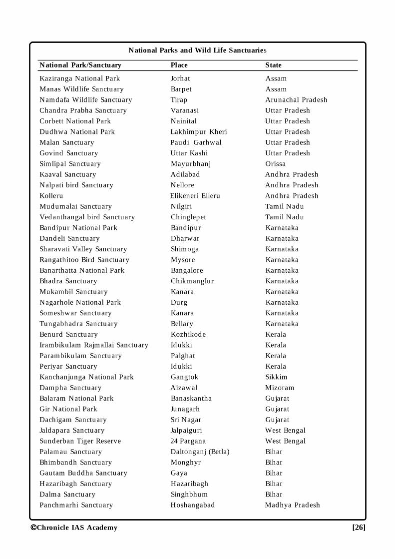
National Parks and Wild Life Sanctuaries
National Park/Sanctuary Place State
Kaziranga National Park Jorhat AssamManas Wildlife Sanctuary Barpet AssamNamdafa Wildlife Sanctuary Tirap Arunachal PradeshChandra Prabha Sanctuary Varanasi Uttar PradeshCorbett National Park Nainital Uttar PradeshDudhwa National Park Lakhimpur Kheri Uttar PradeshMalan Sanctuary Paudi Garhwal Uttar PradeshGovind Sanctuary Uttar Kashi Uttar PradeshSimlipal Sanctuary Mayurbhanj OrissaKaaval Sanctuary Adilabad Andhra PradeshNalpati bird Sanctuary Nellore Andhra PradeshKolleru Elikeneri Elleru Andhra PradeshMudumalai Sanctuary Nilgiri Tamil NaduVedanthangal bird Sanctuary Chinglepet Tamil NaduBandipur National Park Bandipur KarnatakaDandeli Sanctuary Dharwar KarnatakaSharavati Valley Sanctuary Shimoga KarnatakaRangathitoo Bird Sanctuary Mysore KarnatakaBanarthatta National Park Bangalore KarnatakaBhadra Sanctuary Chikmanglur KarnatakaMukambil Sanctuary Kanara KarnatakaNagarhole National Park Durg KarnatakaSomeshwar Sanctuary Kanara KarnatakaTungabhadra Sanctuary Bellary KarnatakaBenurd Sanctuary Kozhikode KeralaIrambikulam Rajmallai Sanctuary Idukki KeralaParambikulam Sanctuary Palghat KeralaPeriyar Sanctuary Idukki KeralaKanchanjunga National Park Gangtok SikkimDampha Sanctuary Aizawal MizoramBalaram National Park Banaskantha GujaratGir National Park Junagarh GujaratDachigam Sanctuary Sri Nagar GujaratJaldapara Sanctuary Jalpaiguri West BengalSunderban Tiger Reserve 24 Pargana West BengalPalamau Sanctuary Daltonganj (Betla) BiharBhimbandh Sanctuary Monghyr BiharGautam Buddha Sanctuary Gaya BiharHazaribagh Sanctuary Hazaribagh BiharDalma Sanctuary Singhbhum BiharPanchmarhi Sanctuary Hoshangabad Madhya Pradesh
Chronicle IAS Academy [27]
Madhav Nation Park Sheopuri Madhya PradeshBori Sanctuary Hoshangabad Madhya PradeshKanha Kisli National Park Balaghat Madhya PradeshBandhavgarh National Park Shahdol Madhya PradeshIndravati National Park Bastar Madhya PradeshFossil National Park Mandla Madhya PradeshPanna National Park Panna Madhya PradeshSanjay National Park Sidhi (Sarguja) Madhya PradeshSatpura National Park Hoshangabad Madhya PradeshRatapani Sanctuary Raisen Madhya PradeshBorivalli Sanctuary Mumbai MaharashtraTadowa Sanctuary Chandrapura MaharashtraPench Sanctuary Nagpur MaharashtraNavgaon National Park Bhandara MaharashtraRanthambhore National Park Sawai Madhopur RajasthanSariska Sanctuary Alwar RajasthanKeoladeo Ghana Bird Sanctuary Bharatpur RajasthanSikridevi Sanctuary Mandi Himachal PradeshRohella Sanctuary Kullu Himachal PradeshRoss Island National Park Ross Island Andaman and NicobarMarine National Park Andaman Andaman and Nicobar
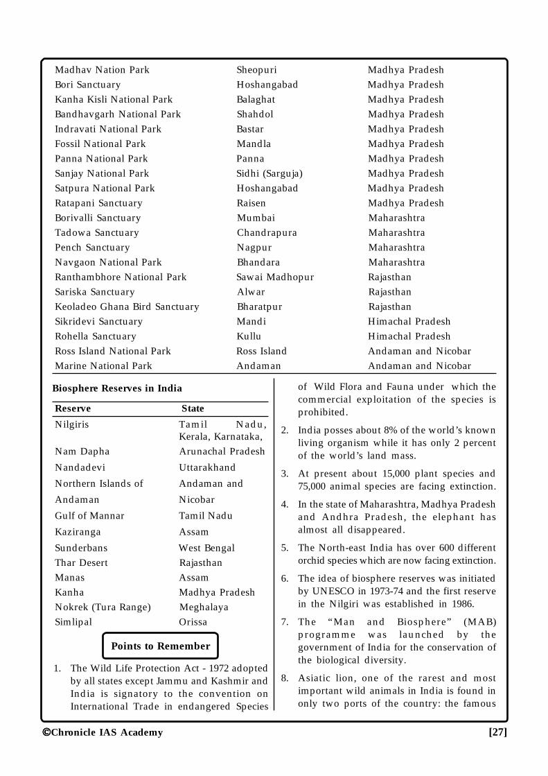
Biosphere Reserves in India
Reserve State
Nilgiris Tamil Nadu,Kerala, Karnataka,
Nam Dapha Arunachal Pradesh
Nandadevi Uttarakhand
Northern Islands of Andaman and
Andaman Nicobar
Gulf of Mannar Tamil Nadu
Kaziranga Assam
Sunderbans West BengalThar Desert RajasthanManas AssamKanha Madhya PradeshNokrek (Tura Range) MeghalayaSimlipal Orissa
Points to Remember
1. The Wild Life Protection Act - 1972 adoptedby all states except Jammu and Kashmir andIndia is signatory to the convention onInternational Trade in endangered Species
of Wild Flora and Fauna under which thecommercial exploitation of the species isprohibited.
2. India posses about 8% of the world’s knownliving organism while it has only 2 percentof the world’s land mass.
3. At present about 15,000 plant species and75,000 animal species are facing extinction.
4. In the state of Maharashtra, Madhya Pradeshand Andhra Pradesh, the elephant hasalmost all disappeared.
5. The North-east India has over 600 differentorchid species which are now facing extinction.
6. The idea of biosphere reserves was initiatedby UNESCO in 1973-74 and the first reservein the Nilgiri was established in 1986.
7. The “Man and Biosphere” (MAB)programme was launched by thegovernment of India for the conservation ofthe biological diversity.
8. Asiatic lion, one of the rarest and mostimportant wild animals in India is found inonly two ports of the country: the famous
Chronicle IAS Academy [28]
Gir National Park in Gujarat and theChandraprabha wildlife sanctuary ofUttar Pradesh.
9. The one horned rhinoceros is also vanishingbut now it is found in Assam’s KazirangaNational Park and Manas wildlife sanctuary.
10. The Dachigam National Park of Kashmirprotects the hangul or Kashmir Stag.
11. The largest areas reserved for sanctuariesare in Madhya Pradesh, Andhra Pradesh,Gujarat and Karnataka, but the proportionof sanctuary area to forest area is highest inGujarat.
12. The word “National Park” refers to relativelylarge area of one or more ecosystem thathas not materially altered by humanexploitation and occupation. The place isespecially meant for plants, animals andhabitats for special scientific education.
13. The concept of “Wildlife-Sanctuary” is moreor less similar to the national park but it is
chiefly meant to protect wildlife andconserve species. Its boundary is not fixedby the legislation.
14. The concept of “Biosphere Reserves” refersto the multipurpose protected area topreserve the genetic diversity of theecosystem. Its main objectives are; toconserve integrity and diversity of plants,animals and micro-organism, to providefacilities for education, awareness andtraining and to promote research onecological conservation.
15. The “Operation Tiger” was launched byWWF in 1973 to protect the tiger fromfurther extinction.
16. Of the total 27 tiger reserves in India,Nagarjunasagar Tiger reserve of AndhraPradesh is the largest with an area of3,568 sq km.
17.The National wildlife Action plan wasadopted in 1983.
���
Chronicle IAS Academy [29]
AGRICULAGRICULAGRICULAGRICULAGRICULTURETURETURETURETURE CHRONICLEIAS ACADEMYA CIVIL SERVICES CHRONICLE INITIATIVE
Indian agriculture provides livelihood toabout 70% of the work-force, contributes nearly35% of net national product and accounts forsizeable share of total value of country’s exports.It also supplies bulk of wage goods required bynon - agricultural sector and raw material for alarge section of industry.
Cropping Season in India
India has many growing seasons due toprevalence of high temperature through a longperiod. Different crop seasons are:
(a) Kharif: Crops are sown at the beginningof the South -West monsoon and harvested at theend of the South -West monsoon.
Important crops: Jowar, bajra, rice, maize,cotton, Jute, groundnut, sugarcane, tobacco etc.
(b) Rabi: Crops need relatively cool climateduring the period of growth but warm climateduring the germination of their seed andmaturation.
Sowing season- (October -December) andharvesting season (February - April).
Important Crops: Wheat, barley, gram,linseed, mustard, masur, peas and potatoes.
(c) Zaid: Crops which are being raisedthroughout the year due to artificial irrigation.
(i) Zaid Kharif: Sown in August-Septemberand harvested in December-January. Importantcrops include rice, jowar, rapeseed, cotton andoilseeds.
(ii) Zaid Rabi: Sown in February - March andharvested in April -May. Important crops arewatermelon, cucumber, leafy and othervegetables.
Total geographical area of India: 328.7 m. ha.
Total New sown Area: 140.27 m. ha. (46.12%)
Total Net Irrigated Area: 38.80 m. ha (27.66%of net sown area).
In Eastern India, east of 80° East meridian andin the coastal lowland (West coastal lowlandsouth of Surat) rice is the dominant crop. Tea andjute are distinctive crops of eastern India. Westof 80° East meridian and north of Surat, wheat isthe dominant crop. 100 cm Isohyet is the majordividing line.
Jowar, bajra, pulse, groundnut and cotton arethe chief crops in the Indian Plateau and wheat,various pulses, cotton, mustard, jowar, bajra, etc.in the alluvial plains of Uttar Pradesh, Haryanaand Punjab.
Types of Farming
1. Shifting Cultivation: Prevalent in the forestareas; cultivation is done over the burnt forestswhich are abandoned when fertility dwindles. Ithas different name indifferent states. Main crops:dry paddy, wheat, maize, sugar cane etc.
2. Sedentary or Settled Cultivation: Mainlyconfined to plateau and highland areas. Maincrops: Sugarcane, Oilseeds, Cotton.
3. Capitalist Farming: Practised on largeholdings called, farm estates. It is highly capitalintensive type of agriculture. Main crops:plantation crops.
Description of crops
� Rice
It covers about 25% of the total gross croppedarea of the country.
Climatic Conditions: Rain fall more than 125cm.; clayey loam soil is best suited; averagemonthly temperature should not fall below 21°Cas in Orissa, West Bengal, Bihar, Assam and SouthIndia.
Area: Coastal India (south of Bombay on thewestern coast), Eastern India, Chhattisgarh Plain,Wainganga valley, alluvial plain of West Bengal,Mahanadi delta, eastern Assam valley, Cauverydelta.
Chronicle IAS Academy [30]
In West Bengal rice is grown in 3 differentagronomic seasons-
(1) Aus, sown in Feb-March,
(2) Aman, sown in March-April &
(3) Boro, sown in June.
In terms of production as % of total riceproduction, West Bengal ranks first followed byT.N., U.P., Andhra Pradesh, Punjab & Bihar.
In terms of yield (kg/ha), Tamil Nadu ranksone followed by Punjab, Andhra Pradesh andKarnataka.
� Wheat
It covers about 14% of total cropped area ofthe country.
Climatic Conditions: Cool climate; 30 cm.rainfall during the growing period; clayey alluvialis the best suited soil; raised mainly in area ofrainfall annually less than 100 cm.
Crops: (1) Common bread wheat-Mostcommon in the Indo-Gangetic Plains; the majorpart of total wheat produced in India. (2) Durum/Marcaroni wheat-Susceptible to yellow rust; mostcommon in the north-western India and the blacksoils of Indian Plateau. (3) Emmer/TriticumDicocum wheat-Produced in Karnataka, TamilNadu and Maharashtra. (4) Indian dwarf wheat-Produced in limited areas of M.P. and U.P.
About 70% of total wheat area in India isunder irrigation.
About 40% of total wheat area in India is rain-fed.
In terms of area as a percentage of total areaunder wheat, UP ranks one followed by MP,Punjab, Rajasthan, Bihar and Haryana.
In terms of production as % of total wheatproduction in India, U.P. ranks one followed byPunjab, Haryana, Bihar.
In terms of yield (kg/ha) Punjab ranks onefollowed by Haryana, West Bengal, Rajasthan,Uttar Pradesh.
� Barley
For the growth of barley the climaticconditions are the same as for wheat. However itcan well thrive even in more cool climate as itspotential area is much wider than the wheat.
Barley is used for the production of maltwhich again is used for brewing beer and otheralcoholic products.
In terms of production as % of total barleyproduction in India, Uttar Pradesh ranks firstfollowed by Rajasthan, Haryana, Punjab.
� Maize
Climatic Conditions: Area of 4.5 months freefrom frost; temperature during growing periodof 21°C to 27°C but should not fall below 13°C;rainfall between 50 to 100 cm.; well drained loamysoils rich in nitrogen; grown as kharif crop in allthe states.
Area: Mainly north of a line connecting Suratwith Kolkata (excluding Kutch, West Rajasthanand Ladakh), in the North East (Meghalaya,Nagaland, Manipur, Mizoram), northern districtsof Andhra Pradesh and the adjoining districts ofMaharashtra and M.P.
In terms of area as % of total area under maizeU.P. ranks first followed by Rajasthan, M.P., Biharand Gujarat.
In term of production as % of total productionin India U.P. also ranks first followed by formerBihar, Karnataka, M.P., Rajasthan.
� Jowar/Sorghum
Climatic Conditions: Annual rainfall below100 cm, needs 30 cm rainfall during the growingseason; mean monthly temperature between 20°and 33°C, clayey deep regur and alluvium forbetter field.
Area: On Indian Plateau, west of 80°Emeridian; south of Pune 80% agricultural landunder it; in Andhra Pradesh, Maharashtra andKarnataka as rabi & as kharif elsewhere.
In terms of area as % of total area under itMaharashtra ranks first followed by Karnataka,M.P., Andhra Pradesh and Rajasthan. In terms ofproduction as % of total production Maharashtraalso ranks first followed by Karnataka, M.P., andAndhra.
� Other Coarse Cereals
Beside maize and jowar a variety of coarsecereals are grown in India. These are mostly rainfed crops like bajra, ragi, etc.
Chronicle IAS Academy [31]
Coarse cereals altogether accounts 28-30% ofthe total area under food crops and about 18.5%of total annual food production.
Though they have little commercial valuethey are liable to be grown in even ecologicallyunfriendly areas and have been adopted by thepoor section of the society.
In terms of area as % of total area under bajraRajasthan ranks first followed by Maharashtra,Gujarat, U.P. and Haryana.
In terms of production as % of totalproduction of bajra Rajasthan ranks first followedby Gujarat, U.P. Maharashtra and M.P.
� Pulses
Kharif Pulses: Arhar/ Tur, Moong, Urad,Moth, etc; grown throughout India.
Rabi Pulses: Gram, Peas, Khesari, Masur,Urad, etc.; grown in north India.
Pulses occupy about 13% of total Indiancropped area while 90% area under it is rainfed.
In terms of area as % of total area under pulsesM.P. ranks first followed by Rajasthan,Maharashtra, U.P. and Orissa.
In terms of production as % of totalproduction: Haryana ranks first followed byPunjab, M.P. and U.P.
Oil Seeds
A. Groundnut: India ranks first in the worldboth in area and production.
Climate: Highly susceptible to frost so notgrown in the winter season north of Tropic ofCancer. Well drained sandy soil is more suitablefor it
Area: Raised as kharif throughout India butas Rabi in Tamil Nadu, Karnataka, AndhraPradesh, Orissa. Kharif crop covers more than90% area.
In terms of area Gujarat ranks first followedby Andhra Pradesh, Tamil Nadu, Karnataka andMaharashtra.
In terms of production Gujarat also ranks firstfollowed by Andhra Pradesh, Tamil Nadu,Karnataka and Maharashtra.
B. Rapeseed & Mustard
Climate: Like wheat they thrive only in coolclimate and frost damages it. It is grown as Rabicrop.
U.P. and Rajasthan are the chief producer andtogether they account for 60% of the countryproduction.
In terms of area U.P. ranks first followed byRajasthan, Haryana and M.P.
In terms of production Rajasthan ranks firstfollowed by U.P., Haryana and M.P.
C. Sesamum/ Til
India shares about one-third of worldproduction and area wise first in the world.
Climate-Raised throughout India on light soilas kharif in the northern India and as Rabi cropin south India.
The main producing states are Orissa,Karnataka and Gujarat.
D. Linseed
India accounts 10% of world production andarea wise stands first in the world.
Main producing states are M.P., U.P.,Maharashtra, Bihar and Rajasthan.
E. Castorseed
India contributes 20% of world productionand area wise stands first in world.
Climate: Generally raised as a mix crop intropical and sub-tropical climate. In India almostall area under this crop is rainfed.
Raised as kharif crop in North-India and asrabi in South-India.
Main producing states are Gujarat, AndhraPradesh, Orissa, Karnataka & T.N.
F. Niger Seed
Area wise first in the world;
Used for making soap.
Main producing states are M.P., Orissa,Maharashtra and Bihar.
G. Sunflower
Area wise first in the world raised as rabi crop.
Chronicle IAS Academy [32]
Maharashtra alone shares about 75% of thecountry production.
� Cotton
Climate: A sub-tropical crop; temperature-above 21°C and 200 frost free days; rainfall- 75cm. during the growing season; regur soil in therainfed area and heavy alluvial soil in the irrigatedarea are most suited.
Area: Mainly in area west of 80°E; W. Punjab,Haryana, SE-Rajasthan, black cotton soil of Malwaplateau, Nagpur plain, Kathiawar and Gujaratplain, N-Karnataka and neighbouring AndhraPradesh, Maharashtra and W-T.N..
In terms of area under cotton Maharashtraalso ranks first followed by Gujarat, AndhraPradesh, Punjab.
In terms of production, Maharashtra alsoranks first followed by Gujarat, Punjab, AndhraPradesh and Rajasthan.
In terms of yield, Punjab ranks first followedby Rajasthan and Tamil Nadu.
� Jute
India ranks first both in area and productionin the world but Bangladesh stands first in export.
Climate : Rainfall between 150 and 300 cm.;humidity over 80%; temperature between 24°Cand 35°C during the growing period; preferredto land of annual flooding.
Area: Lower Brahmaputra Valley, WestBengal plain, Mahanadi delta, NE-Bihar,
In terms of area West Bengal ranks firstfollowed by Bihar, Assam and Andhra Pradesh.
In terms of production West Bengal also ranksfirst followed by Bihar, Assam and Orissa.
� Tobacco
Climate : Rainfall about 60 cm during thegrowing period; humidity about 8%, well drainedsandy loam soil rich in potash is most favourable.
Area: Ganga plain N. Bihar; Godavari andKrishna deltas of Andhra Pradesh; Madurai,Belgaum, Baroda, Satara and Kaira near Mumbai.
In terms of area under tobacco AndhraPradesh ranks first followed by Gujarat,Karnataka, Uttar Pradesh and Bihar.
In terms of production Gujarat ranks firstfollowed by Andhra Pradesh, Uttar Pradesh,Karnataka and Bihar.
� Sugarcane
India has the largest are in sugarcaneproduction in the world and also leads inproduction.
Climate: Temperature about 25°C; hot drywind is inimical; annual rainfall about 50 to 75cm. plus limited irrigation; well drained reddishloamy soil is most suited; cool dry weather duringits maturing period promotes the sucrose content.
Area: South India provides the best suitedtropical conditions with longer crushing period.North India produces the sugar cane in sub-tropical condition. The main area lies in the Gangaplain west of Patna.
In terms of area under sugarcane productionU.P. ranks first followed by Maharashtra, TamilNadu, Karnataka and Andhra Pradesh.
In terms of production U.P. also ranks firstfollowed by Maharashtra, Tamil Nadu, Karnatakaand Andhra Pradesh.
In terms of yield Tamil Nadu ranks firstfollowed by Maharashtra.
� Rubber
In 1902, first of all the rubber plantation wasintroduced on the bank of Periyar river
India is the fourth largest natural rubberproducer in the world only after Thailand,Indonesia and Malaysia.
Area: More than 90% area is concentrated inKerala alone and the rest is spread over in TamilNadu, Karnataka, Andaman and Nicobar islands.
Both in respect of acreage and productionKerala stands first.
� Tea
India accounts about 30% of global outputfollowed by China, Kenya, Sri Lanka. However,Srilanka and Kenya have overtaken India in termsof export.
Climate: Hot climate with the temperaturebetween 21°C and 32°C; rainfall more than 150cm; deep loam soil rich in humus and virgin forest
Chronicle IAS Academy [33]
soil with very little calcium but enough iron arebest suited.
Area: NE-India contributes about 80% of thetotal production and the rest 20% is shared by S.India.
Assam: Either sides of Brahmaputra river andsouth of Assam hills in Cachar.
W. Bengal: Darjeeling and Jalpaiguri. It hasgood flavour so fetches high price.
S. India: Annamalai hills; Hassan andChikmanglur districts of Karnataka; Kottayam,Quilon and Trivandrum districts of Kerala.
Uttarakhand: Dehradun district.
Himachal Pradesh: Dharmashala in Kangradistrict.
In terms of area under tea Assam ranks firstfollowed by W.Bengal, Tamil Nadu, Kerala.
In terms of production Assam also ranks firstfollowed by W.Bengal, Tamil Nadu and Kerala.
In terms of productivity/yield Tamil Naduranks first followed by Kerala.
� Coffee
Arabica and Robusta varieties of coffee aregrown in India accounting for 49% and 51% ofarea under cultivation respectively.
Area: Eastern slopes of Western Ghats inKerala, Karnataka and Tamil Nadu. Karnataka(Chikmanglur, Shimoga and Hassan), TamilNadu (Nilgiri and Palani Hills).
In terms of area under coffee plantationKarnataka ranks first followed by Kerala andTamil Nadu.
In terms of production Karnataka ranks firstfollowed by Kerala, Tamil Nadu and AndhraPradesh.
� Spices
In India about 60 types of spices are grownand since a long time in history India has beenthe chief exporter worldwide. In terms of spicesexport value wise Black Pepper ranks firstfollowed by Chilli.
Chilli: Chief producers are Andhra Pradesh,Karnataka, Maharashtra, Tamil Nadu, etc.
Turmeric: In terms of production AndhraPradesh ranks first followed by T.N. and W.Bengal.
Cardamom: India is the largest producer andexporter. Both in terms of area and production,Kerala ranks first followed by Karnataka andTamil Nadu.
Black Pepper: India is the second largestproducer after Indonesia. Kerala is the largestproducer followed by Karnataka, Tamil Naduand Andaman & Nicobar.
Arecanut: Kerala ranks first in the productionfollowed by Karnataka, Assam & T.N.
Ginger: The chief producers are Kerala,Meghalaya, Orissa, Arunachal Pradesh & H.P.
� Coconut
In terms of number of nuts India ranks secondonly after Indonesia and in terms of Copra Indiaranks third after Indonesia and Philippines.
In terms of area under coconut Kerala alsoranks first followed by Tamil Nadu, Karnataka,Andhra Pradesh, Orissa and Goa.
In terms of production Kerala also ranks firstfollowed by Tamil Nadu, Karnataka, AndhraPradesh, W. Bengal and Orissa.
� Fruits
A. Mango: Alphanso of Maharashtra,Bangnapalli of Andhra Pradesh, Dashehari& Langra of U.P., Malda of W. Bengal aresome famous varieties. U.P. is the largestproducer followed by Bihar, AndhraPradesh, West Bengal and Maharashtra.
B. Banana: India is the second largest producerafter Brazil. The chief producers are TamilNadu, Maharashtra, Gujarat, M.P. and Kerala.
C. Grape: The famous variety “Anab-e-Shahi”productivity is highest in India. The chiefproducing areas are Coorg district ofKarnataka; Wynad in Kerala; Nilgiri,Sholapur and Ahmednagar districts ofMaharashtra.
D. Citrus: Maharashtra ranks first and NagpurMandarins is considered to be the best inthe world.
Chronicle IAS Academy [34]
E. Apple: North-west Himalayan region covers95% of the total area and 85% of the totalproduction
F. Pineapple: The chief producers are Keralaand North Eastern states.
G. Cashewnut: India ranks first both in areaand production. Kerala ranks first inproduction by Andhra Pradesh, Orissa, Goaand Karnataka.
Points to Remember
1. India ranks 7th in the world in terms of totalgeographical area but 2nd in terms ofcultivated land.
2. India has total geographical area of 328.7million hectares out of which 142.60 mhectares is the net sown area. It is about46.59%. Arunachal Pradesh has only 3.2percent area under net cultivation while inHaryana and Punjab it is 82.20 percent.
3. In Punjab, more than 94% of the totalcropped area is irrigated.
4. In India, out of the net cropped area of142.82m hectares, only 55.14 million hectares(38.5%) are irrigated.
5. India stands next only to China in theproduction of rice contributing 21.5 percentof the world population.
6. Bengal is the largest rice producing statecontributing to more than 14.6% of the riceproduction of India, but in term of yield perhectare Punjab and Haryana occupy the toprank.
7. Soviet Union, United States and China arethe countries which produces more wheatthan India. In term of production U.P. ranksfirst while in terms of yield Punjab ranksfirst in India.
8. India is the second largest producer ofsugarcane after Brazil and it has the largestarea under sugarcane cultivation.
9. India grows 7% of the total world productionof tobacco which is next only to China, U.S.Aand Brazil.
10. Kerala is considered as the “spice state ofIndia”.
11. “Harrison” and “Virginia Gold” are the highyielding varieties of tobacco.
���
Chronicle IAS Academy [35]
CHRONICLEIAS ACADEMYA CIVIL SERVICES CHRONICLE INITIATIVE
IRRIGAIRRIGAIRRIGAIRRIGAIRRIGATIONTIONTIONTIONTION
The process of supplying water to the cropsby artificial means such as canals, wells, tube-wells from the source of water such as river, tanks,ponds or ground water is called irrigation. Themonsoon rainfall in India is uncertain & highlyvariable. The temporal & spatial variability ofrainfall accentuates the need for artificial supplyof water to the crops. Hence irrigation in Indiabecomes indispensable.
Apart from vagaries of monsoon, the crop-ping pattern in India also enhances the need forirrigation in the areas with sufficient rainfall.Certain crops like rice, sugarcane, jute, cotton,chalks require irrigational water. It is estimatedthat production of irrigation crops is 50 to 100percent higher than that of unirrigated cropsunder similar geographical conditions. Introduc-tion of HYV seeds and green revolution havefurther increased the need for irrigation.
Reasons for Water Scarcity
• The rainfall is highly variable.• 18% of water available is polluted and unfit
for drinking.• Almost all parts of India are affected either
by flood or drought.• Demand for water is increasing due to rapid
increase in population.• The management of available water re-
sources in not proper.• The storage facilities are very poor.• Over-exploitation of ground water of- ten
result in the intrusion of saline sea water incoastal areas.
• Cultivation of hybrid varieties of paddy,wheat, cotton, sugarcane and tobacco whichconsume more water.
• Evaporation loss of water stored in largereservoirs and loss by seepage in long canalsystems.
• Siltation of water bodies.
• Dumping of various types of pollutants intowater bodies reduce its usability.
The source of irrigation depends upon thewater availability, topography, relief,availability of soil and moisture,requirements of crop. Important sources ofirrigation in India include:
(i) Wells: Wells are the most basic sources ofirrigation in India. It depends upon the avail-ability of ground water. The Great Plains, thedeltaic regions of the Mahanadi, Godavari,Krishna and Cauvery are important regionsof well irrigation.
(ii) Tanks: Located in the rocky region of thePeninsula. The tanks are non - perennial innature and additional water is needed insummer. About 11% of the net irrigated areain India is under tank irrigation. TheKarnataka plateau, coastal Maharashtra,Andhra Pradesh, Tamil Nadu have this kindof irrigation.
(iii)Canals: India has one of the world’s largestareas under canal irrigation. About 40% ofthe net irrigated area comes under canalirrigation. Uttar Pradesh, Punjab, Haryana,Rajasthan, Bihar, Andhra Pradesh are themain regions.
Multi-purpose projects aim at:
(a) Flood Control
(b) Promotion and operation of irrigationschemes, water supply.
(c) Generation and Transmission of electricpower
(d) Promotion and control of irrigation
(e) Afforestation and other economic activitygeneration.
For the better utilization of the total potentialthe irrigation schemes have been divided into :
(1) Major Projects: Cultivable command areaof more than 10,000 hectare, (includingcanal irrigation)
Chronicle IAS Academy [36]
(2) Medium Project: Cultivable command areabetween 2000 and 10000 hectare.
(3) Minor Projects: Cultivable command arealess than 2000 hectare, include mainly well-irrigation.
(4) Micro Projects: Drip irrigation and the useof sprinklers.
In Punjab 75% of the net sown area is irrigated,in Haryana & U.P. this ratio is of about 57%, inTN. About 49% in U.P. about 38%, in Maharashtraonly 9% are irrigated.
MAJOR IRRIGATION & POWER
PROJECTS
1. Bhakra-Nangal Project: Joint venture of Punjab,Haryana & Rajasthan; on river Sutlej; BhakraDam is the highest straightway gravity dam inthe world with a reservoir named ‘GovindSagar lake’. Nangal Dam is 13 km downstreamof Bhakra dam. It has four power houses (total1204 Mw) at Gonguwal, Kotta, Left Bank &Right Bank.
2. Rihand-Dam Project: Across river Rihandon MP-UP border in Mirzapur District.Rihand is the largest man-made lake in In-dia; reservoir is known as ‘Govind BallabhPant Sagar’.
3. Chambal Project: A joint venture ofRajasthan & MP; on river Chambal com-prises there dams Gandhi Sagar Dam (MP),Rana Pratap Sagar (Rajasthan), JawaharSagar (Rajasthan).
4. Gandak Project: A joint venture of UP &Bihar & Nepal; on Gandak river; a barragenear Valmiki Nagar.
5. Nagarjuna Sagar Project: On Krishna Rivernear Nandikonda village in Andhra.
6. Kosi-Project: On River Kosi; a joint ventureof Bihar & Nepal, a barrage near HanumanNagar in Nepal.
7. Tungabhadra Project: A joint venture ofAndhra & Karnataka; on river Tungabhadra.
8. Beas Project: A joint venture of Punjab,Haryana & Rajasthan; on river Beas; a damat ‘Pong’.
9. Hirakund Project: On Mahanadi in Orissa,its dam is longest in the world.
10. Damodar Valley Project : (W. Bengal &Bihar) have a series of small dams on thetributaries of river Damodar i.e. Tilaiya (R.Barakar), Konar (R. Konar), Maithan (R.Barakar), Panchet (R. Damodar) and 3 Ther-mal Power stations at Bokaro, Chandrapura& Durgapur.
11. Kakrapara Project: on river Tapi in Gujarat.
12. Machkund Project: on river Mach- kundAndhra & Orissa joint venture.
13. Malprabha Project: on river Malprabha inKarnataka.
14. Mayurakshi Project: on river Mayurakshiin W. Bengal.
15. Hansdeo Bango Project: on river Hansdeoin MP.
16. Bhima Project: have two dams Pawna damat river Pawna & Ujjaini dam on riverKrishna in Maharashtra.
17. Jaikawadi Project : on river Godavari inMaharashtra.
18. Tawa irrigation Project: on river Tawa, atributary of Narmada in M.P.
19. Tihri Dam Project: on river Bhagirathi nearDev Prayag in UP.
IMPORTANT HYDRO
ELECTRIC PROJECTS
1. Tata HEP: on Nila-Mulas river inMaharashtra; power to Bombay.
2. Pykara HEP: T.N. on Pykara river inNilgiri; 1st HEP in T.N.
3. Mandi HEP: 1st in Himalayan region on atributary of Beas.
4. Balimela HEP: Orissa.
5. Ukai HEP: Maharashtra on river Tapi.
6. Salal HEP: J & K.
7. Chukha HEP: Bhutan-constructed by India& surplus energy is purchased by India forits NE-states.
8. Koyna HEP: Maharashtra on Koyna riverat Deshmukh-wadi.
9. Sivasamudram Scheme: In Karnataka atSivasamudram falls on Cauvery.
Chronicle IAS Academy [37]
10. Sharavati HEP: Karnataka across Sharavatinear Jog fall in Shimoga district.
11. Mettur HEP: T.N. Stanley Dam on riverCauvery.
12. Papanasam Scheme: T.N. On Tamraparniriver in Tirunelveli district.
13. Sabrigiri HEP: Kerala; Dam across Pambariver.
14. Sarda HEP: U.P. across Sarda river inNainital district.
15. Idukki HEP: Keralahave three storage damson rivers Periyar, Cherutheni, Idukki.
16. Kalinadi HEP: Karnataka on Kalinadi riverin N. Kanara district.
India’s potential of HEP: 5th after Zaire,Former USSR, Canada and USA.
North-Eastern India has 30% of India HEPpotential
Himalayan region has 30% of India HEPPotential.
Peninsular India has 40% of India HEPpotential (1/2 in the east flowing rivers rising inthe Western Ghats)
We have developed only 40% of the totalpotential till now.
SUGGESTIONS FOR
SUSTAINABLE WATER
RESOURCE UTILISATION
• Greater emphasis on ground waterutilisation as a part of comprehensive landuse policy and afforestation programme.
• Introducing water harvesting technology foroptimum utili- sation of rain water and sur-face runoff to sustain use of ground water.Greater emphasis of small storage schemes.
• Involvement of local people by communityparticipation.
• Restoring original cropping pattern toprevent any drought type situation due tointroduction of HYVs.
• Judicious use of water involves:
(a) Drip irrigation
(b) Low energy precision application
(c) Reusing urban wastewater
(d) Saving water used in industries
(e) Municipal water conservation managingboth supply and demand of water.
• Development of National Water Manage-ment policy not only to improve supply butalso to manage demand better.
POINTS TO REMEMBER
• Wells provide about 45 percent irrigation tothe net irrigated area in India.
• Tank Irrigation is chiefly confined to westBengal, Bihar and Orissa and it accounts forabout 10 percent of the net irrigated area.
• The “Canal Irrigation” is chiefly practisedin U.P., Punjab, Haryana and AndhraPradesh and it accounts for about 40 per-cent of the net irrigated area.
• The Nuclear Power Stations are located atTarapur (Maharashtra) Kota (Rajasthan),Narora (U.P), Kalpakkam (Tamil Nadu),Kakrapara (Gujarat) and Kaiga (Karnataka).
• About 91.5 percent of the surface wa t e rflows into sea, 37% of the ground waterresources is utilized and 84% of water is usedfor irrigation in India.
• About 38 percent of the net sown area isunder irrigation in India; in Mizoram it isonly 7.3 percent while in Punjab it is 90.8percent.
• The areas adjacent to Krishna- Godavaridelta and Cauvery delta such as Punjab,Haryana and Western U.P. have more than60 percent of the areas under irrigation.
• The wells and tube wells irrigation predomi-nates in Gujarat where 78.4 percent of thenet irrigated areas fall under it.
• According to the Water Treaties norivervalley projects falls within the jurisdictionof a single state.
• The “Farakka Accord” was concluded in1996. It cemented the controversy betweenIndia and Bangladesh which arose with thebuilding of Farakka dam on river Ganga innear Calcutta.
Chronicle IAS Academy [38]
• The “Mahakali River Treaty” between Nepaland India was concluded in June 1997 whichconcluded rivers like Mahakali Sarda bar-rage, Tanakpur barrage and PancheswarProjects.
• According to the Indus Water Treaty 80% ofthe water of Indus system is made availableto Pakistan and remaining 20 percent toIndia.
• The Damodar Valley Project in India is basedon the Tennessee Valley Authority of U.S.A.With the construction of four dams asMaithan, Konar, Tilaiya and Panchet the“river of sorrow” has turned into “rivers ofplenty”.
• The “Govind Ballabh Pant Sagar Lake” onthe Rihand dam is the largest artificial res-ervoir in Asia.
• The Narmada Valley Project or the SardarSarovar Project is one of the largest projectsunder implementation anywhere in the world.
• The “National Water Grid” envisagesinterlinking the various rivers to utilize theirsurplus water by diverting it to deficit area.The plan consists of to join Ganga to Kaveriand Brahmaputra to Ganga through canals.Through canal, Narmada will be turnedtowards Gujarat and Rajasthan.
• The “Watershed area” refers to thegeohydrological area that drains at a com-mon point.
���
Chronicle IAS Academy [39]
CHRONICLEIAS ACADEMYA CIVIL SERVICES CHRONICLE INITIATIVE
ANIMAL HUSBANIMAL HUSBANIMAL HUSBANIMAL HUSBANIMAL HUSBANDRANDRANDRANDRANDRYYYYY
& FISHERIES& FISHERIES& FISHERIES& FISHERIES& FISHERIES
India has the largest and most varied animalresources in the world and it has about 1/6th of thecattle, 1/2 of the buffalo and 1/5th of the goat popu-lation in the World. India has a good number ofmilch breeds. Sahiwal, Red Singhi and Deoni aresome of the outstanding breeds. India has gone forthe world’s largest and most ambitious milkprogrammes called ‘operation flood’. Droughtbreeds are poor in milk yields, but the bullocks areexcellent draught animals. About 42% of the cattlein the country are draught animals.
India has 3% of the world’s sheep populationand ranks 6th among the sheep-breeding countriesof the world. Rajasthan has the largest (24%) ofIndia’s total stock. India owns one of the largestlivestock populations in the world. It accounts for16% of the cattle population and 57% of buffalopopulation. India has become the largest producerof milk in the world.
••••• Milch Breeds
Gir, Sindhi, Red Sindhi, Sahiwal, Tharpakarand Deoni are some of the outstanding breeds ofmilch cattle. The Gir is a native of Saurashtra andis now found in several parts of Gujarat and ad-joining Rajasthan. The Sindhi breeds are mainlyraised in Gujarat, Rajasthan and Maharashtra al-though it can be raised in several other part ofthe country due to its disease resistant quality.The Red Sindhi breeds have a distinct red colourand hails from Sind in Pakistan. The Sahiwalbreed has its origin in widely found in Punjab,Haryana, Rajasthan, UP and Delhi. The Deonibreed is widely in north western and westernparts of Andhra Pradesh.
••••• Drought Breeds
Among the important drought breeds are in-cluded the Nagori Bauchaur, Malvi, Kherigarh,Hallikar, Khilari, Amritmahal, Kanhayam, Ponwar,Bargur and Siri. The Bagori breed is a native of Jodh-pur and is found in large parts of Rajasthan,Haryana, U.P. and M.P, the Bauchaur breed ismainly found in Bihar. The Malvi is largely concen-trated in the dry western parts of M.P. The Kenkatha
or Kenwariya breed hails from Banda district of U.P.and neigh- bouring areas of M.P. Kheri district ofU.P. is the habitat of Kherigarp breed. The Halikarand Amritmahal breeds are indigenous to Tumkur,Hassan and Mysore districts of Karnataka but arespread all over the Peninsular India. Sholapur andSatara districts comprise the home of the Khillaribreed. The Bargur and the Kangayam breeds arethe natives of Coimbatore district of Tamil Nadu.The Siri grows well in the hilly of Darjeeling andSikkim.
••••• Dual Purpose Breeds
Cattle of these breeds are used both for milkand for drought purpose. The cows are fairly goodyielders of milk while bullocks are good fordrought. Tharparkar, Haryana, Mewati, Kankrej,Rath, Nimari, Dangi, Krishan and Ongole areimportant breeds of this category.
••••• Exotic Breeds
Some of the high milk-yielding exotic breedshave been developed in India. Some foreignbreeds have been crossed with India breeds andnew breeds called cross breed have been devel-oped. Some of the important exotic breeds areJersey, Holstein, Friesian, Swiss-Brown, GermanFeleckvich and Ayrshire.
• Buffalo
About 75% of buffaloes are reared for milk.In wet region of W. Bengal, Assam, Orissa, Keralathey are also used for drafting and ploughing inthe fields. In addition to the fact that India morebuffaloes than any other country of the world,the Indian buffalo breeds are some of the world’sbest breeds. The Murrah, Bhadwari, Jaffarabadi,Surti, Mehsana, Nagpuri and Nili Ravi are amongthe important breeds.
Famous Buffalo Breeds
Murrah: Indigenous to Rohtak, Hissar andGurgaon districts of Haryana Delhi and Punjab.The Murrah male buffaloes are good droughtanimals.
Chronicle IAS Academy [40]
Bhadwari: The Bhadwari breed belongs toAgra and Etawah districts of U.P. and theneighbouring part of Madhya Pradesh andRajasthan.
Jaffarabadi: The Jaffarabadi breeds hails fromthe Gir forest of Gujarat. The buffaloes of thisbreed are quite massive and yield about 2500kg of milk per lactation.
Surti: The Surti breed comes from the Gujaratplain.
Nili Ravi: The Nili Ravi breed belongs to Ferozepur district of Punjab.
Nagpuria: From Vidarbha region ofMaharashtra.
••••• Cow & Oxen
Some important indigenous breeds are:
Gir: From Saurashtra.
Red Sindhi: From Gujarat, Rajasthan andMaharashtra.
Sahiwal:From Delhi, Punjab, Haryana, Rajasthanand western U.P.
Deori: From Andhra Pradesh.
Nagori: Drought breed of Rajasthan.
Bachaur: Drought breed of Bihar.
Kenkatha/Kenwaria: Drought bread from KiuValley in Banda district of U.P.
Amritmahal/Hallikar: Drought breed fromKarnataka.
Siri: Drought breed of Darjeeling and Sikkim.
Ongole: Drought breed of Guntur district ofAndhra Pradesh.
In terms of cows and oxen population M.P.(including Chhattisgarh) ranks first followed byUttar Pradesh (including Uttaranchal), Bihar (in-cluding Jharkhand), West Bengal. In terms of cowmilk production Uttar Pradesh (includingUttaranchal) ranks first followed by west Bengal,Maharashtra and Tamil Nadu.
••••• Sheep
India stands sixth in sheep population in theworld after Australia, Russia, China, Argentinaand New Zealand. More than 4 per cent of theworld’s sheep are reared in India, most of the
sheep are raised in regions which are too dry, toostony or too mountainous to be too good for agri-cultural or for cattle rearing. Most of the Indiasheep are of poor quality yielding inferior woolin less quantity. Their yield of mutton is also verylow. However, some of the good breeds are foundin the northern temperate region. By virtue oftheir sheer number, sheep occupy an importantplace in our economy because they provide uswith wool, mutton and skins.
The distribution of sheep may be properlystudied by dividing the sheep areas into follow-ing regions:
Temperate Himalayan Region: It comprisesJammu and Kashmir, Himachal Pradesh andUttarakhand. The entire region has temperate cli-mate which is quite suit- able for good qualitysheep. The excellent pastures exist on the hillslopes. India’s best quality sheep are reared in theKula, Kangra, Chamba and Kashmir valley at alti-tudes varying from 2000 to 3000 m.
Dry North-Western Region: This region in-cludes Rajasthan and neighbouring parts ofPunjab, Haryana, Western Uttar Pradesh, Gujaratand Madhya Pradesh. There are more than 13million sheep contributing to about half of thetotal wool production of India, however the woolis of comparatively inferior quality and the yieldof wool per sheep is lower than that of the Hima-layan. Marwari breed of Rajasthan is famous forits wool.
Semi-arid Southern Region: This region,com- prising Maharashtra, Karnataka, AndhraPradesh, Tamil Nadu and parts of MadhyaPradesh, supports half the total number of sheepfound in India. In spite of the largest numbers ofships about 50 percent of the sheep of this regionare raised for mutton and produce no wool.
Humid Eastern Region: This region compris-ing Bihar, West Bengal, Assam and Orissa, hashumid climate which is not favourable for sheeprearing. The sheep are mainly reared for produc-ing mutton. In terms of sheep populationRajasthan ranks first followed by AndhraPradesh, Tamil Nadu and Karnataka.
••••• Goat
Goat is called the poor man’s cow because itcan be cheaply reared on meagre grass of poorquality. It is the major supplier of mutton along
Chronicle IAS Academy [41]
with milk, hair and skins. Goats are found in largernumber as compared to sheep and are next onlyto cattle. About one-sixth of the world’s goat isreared in India. Although goats are found in al-most of parts of country their major concentrationis in Bihar (17.31 mil- lion), West Bengal (14.17million), and Uttar Pradesh (13.11 million). Thesestates account for more than half goats of India.
There are some outstanding breeds which arefound in some specific areas. The Himalaya orAngora goat which is also known as the Chamba,Gaddi, Chegu or Kashmiri breed is reared inKashmir and Himachal Pradesh. It produces softwarm hair. The Pashmina reared in Kashmir andKullu valley is world renowned for its pashminafur known as Mohair.
The Jamunapuri is the breed found between therivers Yamuna and the Chambal. It is dual purposebreed providing meat and milk. Among the otherbreeds are the Beetal of Punjab, of the Marwari,Mehsana, Kathiawar and Zalwadi of RajasthanGujarat and Madhya Pradesh and the Barari, Surtiand Deccani of the Peninsular India. Several impor-tant foreign breeds such as Alpine, Nubian, Saanen,Toggenberg and Angora have been used for crossbreeding with the local breeds.
••••• Pigs
There are about 100 lakh pigs providing about5 per cent of India’s meat production in the formof pork. In a poor and thickly populated countrylike India, pig rearing is an important activitybecause pig provides rich meat at low cost. Pigfarming plays in important role in improving thesocio-economic status of sizeable section ofweaker rural communities especially in north-eastern states where every rural family rears pigsfor meat.
••••• Horses and Ponies
About one fourth of the total horses and po-nies are found Uttar Pradesh, Bihar and Jammuand Kashmir. Some of the important indigenousbreeds include Marwari, Kathiawari, Manipuri,Bhutani, Spiti and Chummarti.
••••• Donkey and Mules
Donkey and mules are used as beasts of Bur-den, especially in those areas where modernmodes of transportation cannot be used. Most ofthe donkeys are found in Rajasthan, UttarPradesh, Punjab, Gujarat and Tamil Nadu. Mules
are derived from the crossbreeding of mares anddonkeys. The largest concentration of mules isfound in Uttar Pradesh and West Bengal.
In terms of goat population Bihar (includingJharkhand) ranks first followed by Rajasthan,West Bengal and Uttar Pradesh (includingUttaranchal).
In terms of goat milk production UttarPradesh (including Uttaranchal) ranks first fol-lowed by Rajasthan, Bihar (including Jharkhand)and former M.P.
In terms of Hen and Duck population AndhraPradesh ranks first followed by West Bengal,Maharashtra, Tamil Nadu.
In terms of total milk production UttarPradesh (including Uttaranchal) ranks first fol-lowed by Rajasthan, Bihar (including Jharkhand)and Madhya Pradesh (including Chhattisgarh).
In terms of wool production Rajasthan ranksfirst followed by Jammu and Kashmir, Karnatakaand Gujarat.
••••• Camels
Camel is an extremely useful animal fordrought and transport purposes in the arid landsand is called the ship of the desert. About two-thirds of camels are concen- trated in Rajasthanalone. The rest of the camels are found in the aridsemiarid areas of Punjab, Haryana and Gujarat.
Fisheries
India is the world’s 7th largest producers offish. Production of fish in India is small, beingonly about 2.4% of the total world production.72% of the total catch is brought by non - mecha-nized boats. Marine fisheries account for 2/3rdand inland fisheries for 1/3rd of India’s fish pro-duction. The present per capita consumption offish in India is only 4kgs/year against a desiredconsumption level of 31kgs/year.
Fish Production
Fresh-Water Fish Production Ranks:
1. West Bengal2. Bihar (including Jharkhand)3. Andhra Pradesh4. Assam5. Orissa
Chronicle IAS Academy [42]
Marine Fish Production Rank:
(1) Gujarat
(2) Kerala
(3) Maharashtra
(4) Tamil Nadu
(5) Karnataka.
Total Fish Production Rank:
(1) West Bengal
(2) Gujarat
(3) Kerala
(4) Maharashtra
(5) Tamil Nadu
••••• Marine Fisheries
It includes coastal fisheries, off-shore fishersand deep sea fisheries.
(1) Coastal Fisheries: The coastal zone extendsupto 25m depth. Fish of this belt comprisesof pelagic fishes, like sardines, Mackerel,Lesser Sardines, bottom species like Bombay-duck, silver bellies, Ships, etc.
Herrings, Sardines and Anchovies togetheraccounts for 65% catch.
Tuna, Bonitos, Mackerels, Crustaceans, Shark,Rays, Skates, Flounders, Halibuts account theremaining 35% of total catch.
71% of total production of marine fish is alongthe west coast of Kerala, Maharashtra,Karnataka, Gujarat, Goa. Only about 29% ofthe total marine fish catch comes from the eastcoast of India.
(2) Off-shore and Deep Sea Fisheries: It is notfully developed in India. Large concentrationsof Sardines and Mackerel have been locatedalong the Thiruvanantapuram Goa coast.
••••• Inland Fisheries
Quick growing species with non-preciousfeeding habit are generally selected for culti-vation in ponds, lakes and reservoirs.
Some famous inland species are Cirrhinus-marigala, Cirrhinus -cirrhosa, Puntius,Cornaticus, Katla, Labeo-rohita, etc.
In brackish water estuarine fisheries the fishfound are mostly marine species like Ancho-vies, Cat-fish, Perches, Pearl-spot, etc.
••••• West Coast Fishing
Here the fishing season is from September toFebruary-March.
Here both the continental self and the waterhave more pronounced seasonal cycle andhigher Phosphatic and nitrate contents, somore availability of plankton.
Major fish species are Sardines, Mackarel,Prawn, etc.
••••• East Coast Fishing
Here the fishing season is from July to Octo-ber on the Andhra coast and September toApril on the Coromandel Coast.
Here the circulation of water is less pro-nounced.
Estuarine Fisheries: Chilka and Pulicat Lake.
Per capita fish consumption is one of the high-est in West Bengal but the state production issufficient to meet only 20% of total demand.
••••• Pearl Fisheries
East coasts are more extensive and produc-tive than the west coast and extended fromCape-Camorin to Kilkarai with Tuticorin ascentre. Excellent quality of Oriental Pearls orLingna pearls is found here.
On the West coasts Gulf of Kutch, to the northof Halar district of Saurashtra and nearJamnagar are the productive regions.
The principal pearl fishing areas in India are Gulfof Mannar, Gulf of Kutch and the Palk Bay.
In southern India pearl-oysters are harvestedby divers but in Kutch and Saurashtra theyare exposed to low-water spring tides andhence are easily collected by hand.
Central Marine Fisheries Research Institute islocated at Mandapam Camp.
Points to Remember
1. The animal husbandry constitutes about 30percent of country’s agricultural output.
Chronicle IAS Academy [43]
2. India has about 16% of the cattle, 57% of thebuffalo and one-fifth of the goat populationof the world.
3. In India, the largest number of cattle is foundin Madhya Pradesh, followed by U.P.,Maharashtra and Bihar.
4. The livestock density is greatest inMaharashtra; it is 11 head of livestock perhectare of arable land. Haryana occupies thesecond position with 10 head/ha.
5. In India, of the total milk-production, 63.8 per-cent is obtained from the buffalo, 33.5 percentfrom the cow and 2.7 percent from the goat
6. The annual lying capacity of an Indian henis 60 small eggs in a year as against 180large eggs of white leghorn. India ranks fifthin the egg production in the world.
7. “Operation Flood” is associated with thediary development in India.
8. The Sahiwal yields between 2725 and 3175 kgmilk in a lactation period of 300 to 325 days.
9. The “Amritmahal” and “Jiallikal” ofKarnataka are the best known drought breeds.
10. Nili-Ravi, Bhadwari and Toda breeds of buf-faloes are facing extinction.
11.The average yield of wool is only 700 gramsin India as against 5.7 kg of some of themore exotic breeds.
12. The four large sheep-breeding farms in In-dia are; Mimidipally (Andhra Pradesh),Challekeri (Karnataka), Daksum (Jammuand Kashmir) and Bhaisor (U.P.).
13.The Central Sleep Breeding farm was estab-lished in 1969 at Hissar in Haryana.
14. The Zebu cattle breed is mainly from Indiaand is the ancestor of most tropical Asianand African cattle breeds.
15. The main wool-bearing sheep breed is “Me-rino”.
16. Sleep for wool are best breed in dry climate.
17. “India” has the largest number of goats inthe World.
18. India’s share in the world production of fish-eries is 4.5 percent.
19. In India, the marine fisheries account for twothirds and inland fisheries for a third ofIndia’s fish production.
20. The concentrations of fishing grounds areat high altitudes.
21. The pelagic fish is seasonal because it ismigratory in nature.
22. The Russian delicacy caviar is made fromthe fish called sturgeon.
23. The leading whaling area nowadays is in“north pacific”.
���
Chronicle IAS Academy [44]
CHRONICLEIAS ACADEMYA CIVIL SERVICES CHRONICLE INITIATIVE
MINERALS IN INDIAMINERALS IN INDIAMINERALS IN INDIAMINERALS IN INDIAMINERALS IN INDIA
Minerals are the naturally occurring materialswhich when exploited economically are calledores. Their exploitation is possible when they occurin concentrated form and near the surface. India isendowed with a rich variety of minerals. Theancient archaic landmass contains both metallicand nonme- tallic minerals.
Distribution of Minerals
Though natural endowment in terms ofmineral is quite high, its spatial distribution ishighly uneven. The important areas are:
• North-Eastern Peninsular Belt: This is anancient shield area of peninsular block. Itcomprises of Chhotanagpur Plateau, OrissaPlateau and Chhattisgarh. It contains largequantity of coal, iron ore, manganese, mica,bauxite, copper, etc. It is known as mineralheart of India. It has 100% Kyanite, 93% ironore, 84% coal, 70% chromite.
• Central Belt: The region consists of MP,Chhattisgarh, Andhra Pradesh andMaharashtra. It is the second largest min-eral belt of India. Large deposits of manga-nese, baux- ite, coal, iron ore, graphite andlimestone are found.
• The Southern Belt: Mostly the Karnataka Pla-teau and Tamil Nadu highlands. It has ironore, manganese, chromite but lacks in coal (ex-cept Neyveli coal), mica and copper.
• The South- Western Belt: It includes southKarnataka and Goa. It has iron ore, graniteand clay deposits.
• The North-Western Belt: It extends along theAravallis and adjacent Gujarat. It is importantfor non-ferrous min- eral (copper, lead, zinc),uranium, mica, steatite, etc. It has mineral oilsource in the Gujarat plains.
Iron-ore
India has the vast resources of iron-ore, about20% of total world reserves.
Ore-Types: The ore-types are the following:
(1) Haematite: It has the iron content up to 86%;mainly concentrated in the Dharwar andCuddapah system of the peninsular India.It is also called as “Red Ores” which con-tributes about 85% of total national produc-tion.
(2) Magnetite: It has the iron content of 60%;mainly concentrated in the Dharwar andCuddapah system of Indian peninsula. It isalso called “Black Ores” and contributesabout 8% of total production.
(3) Limonite: It has 30-50% iron content and isthe prominent constitute of laterite. It con-tributes about 7% of total production.
Iron-Ore Reserves
1. Chikmanglur (Karnataka) 26%
2. Singhbhum (Jharkhand) 20%
3. Bastar (Chhattisgarh) 11%
4. Keonjhar (Orissa) 8%
5. Goa 5%
IRON-ORE-AREA EXP. PORT
1. Goa Marmagao
2. Bellary-Hospet Mangalore
3. Kriburu-Bailadela Visakhapatnam
4. Daitari- Nayagadh Paradeep
5. Barbil Haldia
6. Chikmanglur Mangalore
Manganese Ore
It is primarily used for making iron and steeland it acts as basic raw material for manufacturingits alloy. It is also used in manufacturing ofbleaching powder, insecticides, paints, batteriesand China clay. In India it occurs in the form of
Chronicle IAS Academy [45]
sedimentary stratified metamorphic deposits ofDharwar System of Peninsular India.
Ore Types: Psilomelane, Braunite, Pyrolusite.
About 78% of total reserve is found in Nagpurand Bhandara districts of Maharashtra andBalaghat district of M.P. Singhbhum-Keonjhar-Bonai area holds the 11% of total reserve whilethe north Kanara shares 6%.
In terms of reserve M.P. (includingChhattisgarh) ranks first followed byMaharashtra, Orissa and Karnataka.
In terms of production Orissa ranks firstfollowed by Karnataka, M.P. (includingChhattisgarh), Maharashtra and Andhra Pradesh.
Ferro-Manganese Plants: (1) Rayagada (2) Joda(both in Orissa) (3) Tumsar (4) Kamptee (both inMaharashtra) (5) Bhadravati (6) Dandeli (both inKarnataka) (7) Garividi (Andhra Pradesh).
Chromite
It is used for producing “Disodium” used forthe manufacturing stainless steel.
Orissa ranks first in the production bycontributing 90% of the national production,followed by Karnataka, Maharashtra, Jharkhandand Tamil Nadu.
About 96% production of Tamil Nadu isexported to Japan and the rest to Australia.
The production of chromite was of 1324thousand tonnes in 1999-2000.
Nickel
Cuttack and Mayurbhanj districts of Orissais famous nickel reserve and about 80% Orissareserve is only concentrated in Kausa block.
India imports nickel to fulfill its domesticdemand.
Bauxite
These deposits are mainly associated withlaterite soils.
Upto 1988 India was an important importerof aluminium but in 1993 India has become a
major exporter of alumina, mainly to Italy,Germany, U.K., Japan, etc.
In terms of reserves Orissa ranks first followedby Andhra Pradesh, M.P. (includingChhattisgarh), Bihar (including Jharkhand).
In terms of production Orissa also ranks firstfollowed by Jharkhand, Maharashtra, Gujarat andM.P. (including Chhattisgarh).
Copper
Copper ores in India are found as sulphides(Chalcopyrite, Chalcocite, Bronite), oxides(Cuprite) and carbonates (Malachite and Azurite).
They generally occur in veins in PeninsularIndia in highly metamorphosed rocks.
In terms of reserve Rajasthan ranks firstfollowed by Bihar (including Jharkhand), M.P.(including Chhattisgarh), Karnataka and AndhraPradesh.
Gold
Generally found in quartz veins andsometimes associated with iron and coppersulphides.
Karnataka has been leading producer, since1871 when the mining first started in Ooregummines, Champion in Mysore. Other mines areHutti, Topuldedi, Wondalli etc.
Ramagiri Gold field of Anantapuram districtof Andhra Pradesh is another producer
The alluvial gold is found in the beds of Garra-nadi, South Koel, Sanjay, Subarnarekha river ofSinghbhum district of Jharkhand.
Bharat Gold mines Ltd.: Founded in 1972 asa Public Sector which manages all the threeoperating mines of KGF area.
Hindustan Copper Ltd: Recover gold as a by-product along with other metals from its Khetrideposits.
Silver
Generally in the form of Galena, Proustite mixedwith copper, zinc or lead. Produced as by-productduring the smelting of galena or produced from the
Chronicle IAS Academy [46]
lead ore of Kurnool, Cuddapah and Guntur ofAndhra Pradesh; Singhbhum and Ranchi ofJharkhand; Vadodara of Gujarat. Quartzites ofMysore Gold field and cupriferous pyrites ofChitradurg also yield some amount of silver.
Diamond
The diamond is mostly available in Panna(Madhya Pradesh), Rammallakota in AndhraPradesh and also in Krishna river basin. Presentlydiamonds are being excavated from only Pannamines.
Mica
In India the two important ores of mica-Muscovite and Biotite - are found.
In terms of production Bihar (includingJharkhand) ranks first followed by AndhraPradesh and Rajasthan.
Kodarma in Jharkhand is the world’s largestmica mine.
Ruby mica and Bengal mica, which is of highquality, is found in Bihar and Jharkhand.
Green Mica: (lightest of all types), also calledas Electrical Mica; found in Andhra Pradesh.
In Rajasthan green or pink colour high qualitymica are found.
A large quantity of mica is also exported. Butnow India is facing stiff competition with Brazil.
Limestone
Consumption of limestone in India: CementIndustry-67%, Iron & steel industry -16% chemicalIndustry - 4%
In terms of overall production of limestoneM.P. (including Chhattisgarh) ranks first followedby Andhra Pradesh, Rajasthan, Gujarat andKarnataka.
Cement grade Lime-stone are mainly foundin Andhra Pradesh, Karnataka, Gujarat andRajasthan.
Flux grade limestone is mainly produced inMP (including Chhattisgarh), Meghalaya,Andhra Pradesh, Gujarat, Orissa, Jharkhand andKarnataka.
Asbestos
In India Amphibole and Crysolite varieties ofasbestos are found.
Asbestos has the fibrous structure and hasgreat economic importance as it has the capacityto be separated quickly into fine filaments of hightensile strength and its great resistance to fire.
In terms of production Rajasthan ranks firstfollowed by Andhra Pradesh and Karnataka.
Fire Clay
It is used in making bricks for furnace.
These reserves are mostly available inGondwana coal regions and basins. Bihar,Gujarat, Madhya Pradesh, Orissa, Tamil Nadu,Rajasthan, West Bengal and Andhra Pradesh arethe states where fire clay is abundantly available.
Gypsum
Gypsum is a colourless or white mineral whichcontains calcium sulphate. Gypsum is used in theproduction of cement and plaster of Paris.
Most of its deposits are found in Rajasthan,Tamil Nadu, Jammu & Kashmir, HimachalPradesh and Uttar Pradesh. Some deposits arealso found in Gujarat.
Rare-Earths
In the south-west tip of India, on the Keralaand Tamil Nadu coast, an extremely rich mineralslike Ilmenite and Monazite are found.
Ilmenite: From Quilon to Kanyakumari.
Ilmenite and Rutile are the by product in theby-products in the extraction of monazites.
Salt
About 75% of total salt produced in India ismanufactured from saline sea water by theprocess of solar evaporation.
Sea-Salt: Gujarat (Mithapur, Jamnagar,Dharsana, Okha, Bulsar), Maharashtra(Bhandrup, Uran, Bhayandar), Tamil Nadu(Madras and Tuticorin).
Chronicle IAS Academy [47]
Salt Lake: Sambhar, Didwana, Pachbhadra,Lankasara in Rajasthan.
Rock-Salt: Mined at present in Mandi districtDrang and Guna in Himachal Pradesh.
In terms of production Gujarat ranks followedby Tamil Nadu and Rajasthan.
Kyanite
India has the largest reserves of Kyanite inthe world. The distribution is as follows:
Jharkhand: A belt extending from Lapsa Buruto Kharasawan in Saraikela with the importantmines at Lapsa-Buru, Ghagidih, Bachia- Bakro &Mauyaluka.
Maharashtra: Pahargaon & Pipalgaon inSakohi Tehsil and Gorkha- Buranga andAsvalpain in Bhandara districts.
Off-Shore Mineral Wealth
“Polymetallic Nodules”, rich in some met-als like copper, cobalt, nickel, manganese, arelocated on the deep sea floor of the IndianOcean especially on the Central Indian Oceanbasin.
Indian Institute of Oceanography- Goa isthe prime organisation to explore these met-als. India has accorded “Pioneer Investor”status in deep sea bed exploration by the U.N.in 1982.
The International Seabed Authority regis-tered India’s claim for deep seabed mining inAugust 1987 and allotted a site of 1.5 lakh sq.cm. for further exploration in the central IndianOcean.
Points to Remember
1. The occurrence of ore may be traced in Veinsand Lodes, Beds and seams, weatheringproducts and alluvial deposits.
2. A number of organisations such as the “Geo-logical Survey of India”, Mineral ExplorationCorporation Limited”, and Indian Bureau ofMines” are engaged in exploration anddevelopment of mineral resource.
3. The “Damodar Valley” in India has the larg-est concentration of mineral resources.
4. “Lignite” is chiefly found at Neyveli in TamilNadu.
5. Bihar has the largest coal reserve in thecountry; it is 37%, of the total coal reserveof India, West Bengal has 18% and Mad-hya Pradesh has 16 percent.
6. More than 33 percent of India’s iron oreproduction comes from Orissa especiallyfrom Keonjhar, Mayurbhanj and Bonai.
7. Jharkhand ranks second in iron-ore produc-tion and accounts for 27% of the total pro-duction of India.
8. India is the fifth largest producer of manga-nese in the world and in India; MadhyaPradesh occupies the top position with 97%of the total production of India.
9. The diamond mines in India are locatedPanna and Satna in Madhya Pradesh andMirzapur district of U.P.
10. India is the largest producer of mica in theworld. It accounts for about 67% of the glo-bal trade.
���
Chronicle IAS Academy [48]
CHRONICLEIAS ACADEMYA CIVIL SERVICES CHRONICLE INITIATIVE
INDUSTRIES ININDUSTRIES ININDUSTRIES ININDUSTRIES ININDUSTRIES IN
INDIAINDIAINDIAINDIAINDIA
Levels of Industrialization best reflect thelevel of eco- nomic development in a country.Manufacturing is the main process by whichindustries convert primary goods into sec- ondaryproducts by means of value addition, whichinvolves partial or complete transformation of thesame. The location of industries is an importanttheme in geographical studies. It depends on bothgeographic and anthropogenic factors.
Geographical Factors: Raw material, Power,Labour, Transportation, Market, Site, WaterSupply, Climate.
Non-Geographical or AnthropogenicFactors: Capital, Policies, Organization, Banking& Insurance.
Another Set of Factors: Agglomeration effect,Industrial inertia.
Textile Industry
It includes cotton, jute, wool, silk & syntheticfibre textiles. Highest employment inmanufacturing sector is found in textile industry(Cotton, Jute, Wool, Silk).
A. Cotton Textiles
It is the most important industry in terms ofemployment and production of export goods.Although Maharashtra and Gujarat are the chiefcentres, other important states in this field areTamil Nadu, West Bengal, Madhya Pradesh,Karnataka and Andhra Pradesh. Tamil Nadu hasthe largest number of cotton textile mills in India.• Indian Cotton mills produce more yarn than
woven clothes. More than 50% of yarn isspun from short and medium staples.
• Fine and super-fine yarns are produced inMumbai, Ahmedabad and Delhi from im-ported long staple Egyptian and Americanvarieties.
• In yarn production Maharashtra ranks firstfollowed by Tamil Nadu and Gujarat.
• In terms of number of mills Tamil Naduranks first followed by Gujarat, Maharashtra,West Bengal, U.P., Karnataka and AndhraPradesh.
• In India, 58% cloth is of medium variety,36% of course variety and 6% of super finevariety.
Maharashtra: Mumbai (Cottonpolis of India),Sholapur, Pune, Nagpur, Jalgaon, Kolhapur,Akola, Dhulia, Wardha, Satara,
Gujarat: Ahmadabad (Manchester/Boston ofIndia), Kalol, Rajkot, Navasari.
Tamil Nadu: Coimbatore, Chennai, Madurai,Tirunelveli, Tuticorin, Salem.
U.P.: Kanpur, Modinagar, Moradabad,Aligarh, Agra, Etawah, Hathras, Saharanpur,Bareilly, Varanasi.
W. Bengal: Kolkata, Howrah, 24-Pargana,Serampore.
M.P.: Gwalior, Indore, Mandsaur, Dewar.
Karnataka: Devanagiri, Hubli, Bellary,Gokak, Mysore, Bangalore.
B. Jute Textile
India manufactures the largest quantity of jutegoods in the world. Mainly located in WestBengal, followed by Andhra Pradesh, Bihar, U.P.and M.P.
India is the leading producer of jute products.First mill was established in 1854 at Rishra. Thereare at present 73 jute mills in India out of whichWest Bengal has 59 mills, Bihar 3 mills, UttarPradesh 3 mills, Andhra Pradesh 4 mills andAssam, Orissa, Tripura and Madhya Pradesh oneeach.
West Bengal: Titagarh, Jagatdal, Howrah,Ballygunj, Agarpara, Rishra, Serampore, Naihati
Andhra Pradesh: Chitvalshah, Nellimaralla,Eluru, Guntur, Ongole
U.P.: Kanpur, Shahjahanpur,
Chronicle IAS Academy [49]
Bihar: Katihar, Muktapur
M.P.: Rajgarh.
C. Silk Textile Industry
India ranks second after China in the field ofsilk production. There are four types f silk:Mulberry, Tasar, Eri and Muga. All the four Silkvarieties are produced in India. Due to stiffcompetition from Italy and Japan the growth ofIndustry is very sluggish. India is also the secondlargest producer of Tasar after China. India hasalso a monopoly in Muga and Assam is the onlyproducer. The first modern silk factory wasestablished in 1932 at Howrah.
Karnataka: The state produces 52 per cent ofthe Silk cloths in India. It producer about 70% ofnation output and only produces Mulberry. Themain centres are Bangalore, Mysore, Kolar,Mandya, Tumkur, Belgaum and Coorg.
W. Bengal: Next important state, Bengalproduces only 13 per cent. Mostly mulberry isproduced. Production areas are Malda,Murshidabad, Virbhum, Bankura. Famouscentres are Bishnerpur, Baswa, Raghunathpur,Chak-Islampur.
Assam: Third largest producer of non-mulberry silk and only Muga producing area.
Production centres-Goalpara, Kamrup,Nowgong.
Jharkhand: Mostly Tasar is produced.Production: Palamau, Ranchi, Hazaribagh.
Bihar: Bhagalpur.
J&K: Mostly Mulberry is produced. “Tabby”-white plain silk.
Production: Anantnag, Baramula, Doda,Jammu, Udhampur.
Orissa: Tasar producer.Varanasi and Mumbaiare the main silk weaving center.
D. Woolen Textile Industry
The modern woolen textile started with theestablishment of ‘Lai Imli’ at Kanpur in 1876. Itwas followed by Dhariwal in 188& Mumbai1882. At present 625 big and small mills, 1,100hosiery mills & 155 yarn spinning mills arerunning in India.
Punjab leads all other states in production. Italone has 42% of the mills of India. Dhariwal isthe largest center in India. Others are Amritsar,Ludhiana & Kharer. Maharashtra is the Secondlargest producer of woolen textiles. Mumbai isthe major center. Shahjahanpur, Mirzapur,Varanasi, apart from Kanpur are the majorwoolen textile centers. Jamnagar, Ahmedabadand Vadodara are important centres in Gujaratas per Panipat, Faridabad and Gurgaon inHaryana and Bikaner, Alwar, Bhilwara etc. inRajasthan.
Punjab: Dhariwal, Amritsar, Ludhiana,Ferozepur (India largest trading centre of raw wool).
Maharashtra: Mumbai (India’s largest centre)
U.P.: Kanpur, Mirzapur, Agra, Tanakpur.
Gujarat: Jamnagar, Baroda, Ahmedabad.
Karnataka: Bangalore.
W. Bengal: Kolkata.
J&K: Largest producer of handloom andpower loom woolen goods including coarsetweeds, lohis, shawls, pattus.
Rajasthan: Pushkar and Ajmer producehandloom coarse blankets. Charu (Public sector mill)
Sugar Industry
It ranks second amongst the major agro-basedindustries. India ranks first in both area andproduction if both Gur and Khandsari areincluded.
In sugarcane production U.P. ranks firstfollowed by Maharashtra, Tamil Nadu, Karnatakaand Andhra Pradesh.
In sugar production Maharashtra ranks firstfollowed by U.P., Tami Nadu, Karnataka andGujarat.
In Gur production U.P. ranks first followedby Karnataka, Tamil Nadu and Andhra Pradesh.
Maharashtra contributes over one-third ofcountry’s sugar output (36 per cent) followed byUttar Pradesh with 25%, Tamil Nadu and Karnatakaare the other two important sugar producing statesin the country. At Present, there are 465 installedsugar factories in the country (as against 138 during
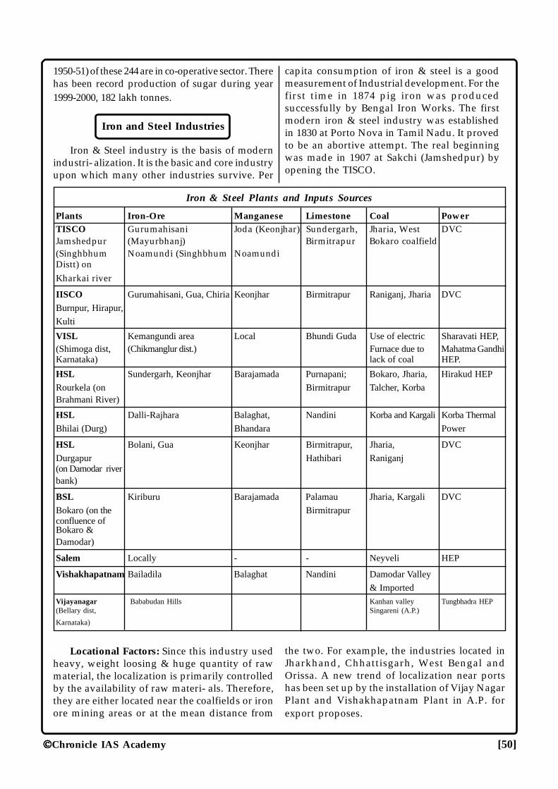
Chronicle IAS Academy [50]
1950-51) of these 244 are in co-operative sector. Therehas been record production of sugar during year1999-2000, 182 lakh tonnes.
Iron and Steel Industries
Iron & Steel industry is the basis of modernindustri- alization. It is the basic and core industryupon which many other industries survive. Per
capita consumption of iron & steel is a goodmeasurement of Industrial development. For thefirst time in 1874 pig iron was producedsuccessfully by Bengal Iron Works. The firstmodern iron & steel industry was establishedin 1830 at Porto Nova in Tamil Nadu. It provedto be an abortive attempt. The real beginningwas made in 1907 at Sakchi (Jamshedpur) byopening the TISCO.
Iron & Steel Plants and Inputs Sources
Plants Iron-Ore Manganese Limestone Coal PowerTISCO Gurumahisani Joda (Keonjhar) Sundergarh, Jharia, West DVCJamshedpur (Mayurbhanj) Birmitrapur Bokaro coalfield(Singhbhum Noamundi (Singhbhum NoamundiDistt) onKharkai river
IISCO Gurumahisani, Gua, Chiria Keonjhar Birmitrapur Raniganj, Jharia DVC
Burnpur, Hirapur,
Kulti
VISL Kemangundi area Local Bhundi Guda Use of electric Sharavati HEP,(Shimoga dist, (Chikmanglur dist.) Furnace due to Mahatma GandhiKarnataka) lack of coal HEP.
HSL Sundergarh, Keonjhar Barajamada Purnapani; Bokaro, Jharia, Hirakud HEP
Rourkela (on Birmitrapur Talcher, KorbaBrahmani River)
HSL Dalli-Rajhara Balaghat, Nandini Korba and Kargali Korba Thermal
Bhilai (Durg) Bhandara Power
HSL Bolani, Gua Keonjhar Birmitrapur, Jharia, DVC
Durgapur Hathibari Raniganj(on Damodar riverbank)
BSL Kiriburu Barajamada Palamau Jharia, Kargali DVC
Bokaro (on the Birmitrapurconfluence ofBokaro &Damodar)
Salem Locally - - Neyveli HEP
Vishakhapatnam Bailadila Balaghat Nandini Damodar Valley
& Imported
Vijayanagar Bababudan Hills Kanhan valley Tungbhadra HEP(Bellary dist, Singareni (A.P.)
Karnataka)
Locational Factors: Since this industry usedheavy, weight loosing & huge quantity of rawmaterial, the localization is primarily controlledby the availability of raw materi- als. Therefore,they are either located near the coalfields or ironore mining areas or at the mean distance from
the two. For example, the industries located inJharkhand, Chhattisgarh, West Bengal andOrissa. A new trend of localization near portshas been set up by the installation of Vijay NagarPlant and Vishakhapatnam Plant in A.P. forexport proposes.
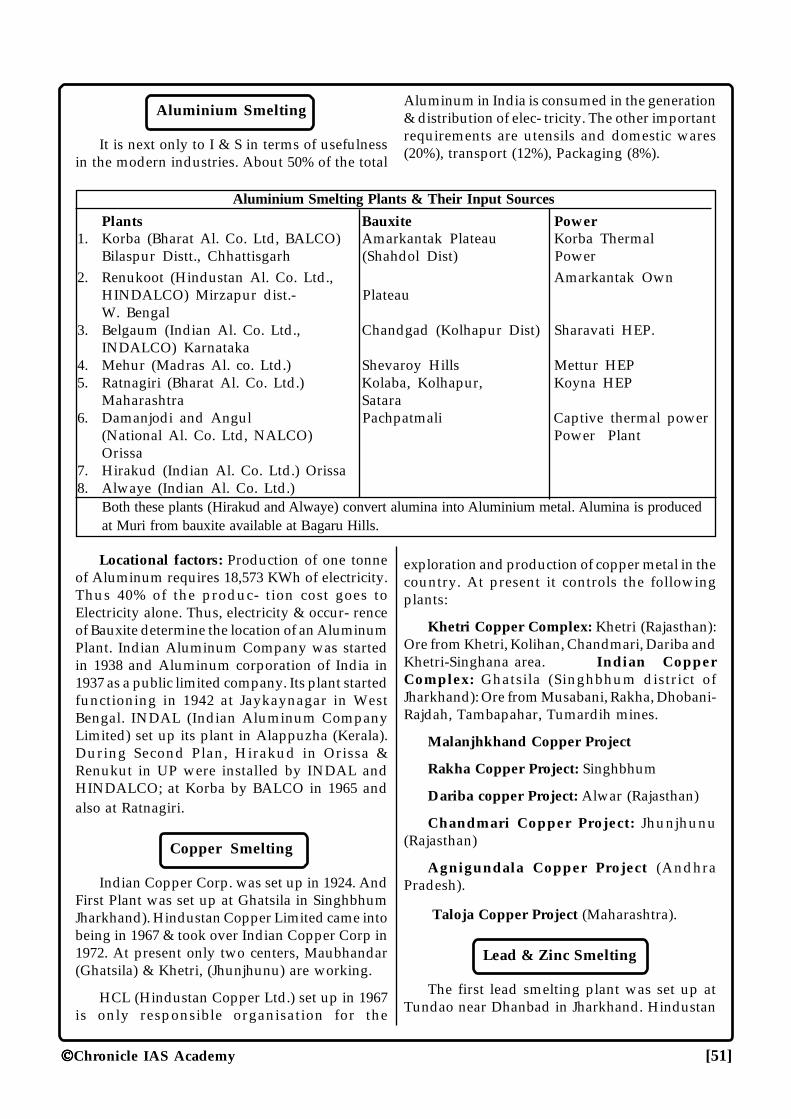
Chronicle IAS Academy [51]
Aluminium Smelting
It is next only to I & S in terms of usefulnessin the modern industries. About 50% of the total
Aluminum in India is consumed in the generation& distribution of elec- tricity. The other importantrequirements are utensils and domestic wares(20%), transport (12%), Packaging (8%).
Aluminium Smelting Plants & Their Input Sources
Plants Bauxite Power1. Korba (Bharat Al. Co. Ltd, BALCO) Amarkantak Plateau Korba Thermal
Bilaspur Distt., Chhattisgarh (Shahdol Dist) Power2. Renukoot (Hindustan Al. Co. Ltd., Amarkantak Own
HINDALCO) Mirzapur dist.- PlateauW. Bengal
3. Belgaum (Indian Al. Co. Ltd., Chandgad (Kolhapur Dist) Sharavati HEP.INDALCO) Karnataka
4. Mehur (Madras Al. co. Ltd.) Shevaroy Hills Mettur HEP5. Ratnagiri (Bharat Al. Co. Ltd.) Kolaba, Kolhapur, Koyna HEP
Maharashtra Satara6. Damanjodi and Angul Pachpatmali Captive thermal power
(National Al. Co. Ltd, NALCO) Power PlantOrissa
7. Hirakud (Indian Al. Co. Ltd.) Orissa8. Alwaye (Indian Al. Co. Ltd.)
Both these plants (Hirakud and Alwaye) convert alumina into Aluminium metal. Alumina is producedat Muri from bauxite available at Bagaru Hills.
Locational factors: Production of one tonneof Aluminum requires 18,573 KWh of electricity.Thus 40% of the produc- tion cost goes toElectricity alone. Thus, electricity & occur- renceof Bauxite determine the location of an AluminumPlant. Indian Aluminum Company was startedin 1938 and Aluminum corporation of India in1937 as a public limited company. Its plant startedfunctioning in 1942 at Jaykaynagar in WestBengal. INDAL (Indian Aluminum CompanyLimited) set up its plant in Alappuzha (Kerala).During Second Plan, Hirakud in Orissa &Renukut in UP were installed by INDAL andHINDALCO; at Korba by BALCO in 1965 andalso at Ratnagiri.
Copper Smelting
Indian Copper Corp. was set up in 1924. AndFirst Plant was set up at Ghatsila in SinghbhumJharkhand). Hindustan Copper Limited came intobeing in 1967 & took over Indian Copper Corp in1972. At present only two centers, Maubhandar(Ghatsila) & Khetri, (Jhunjhunu) are working.
HCL (Hindustan Copper Ltd.) set up in 1967is only responsible organisation for the
exploration and production of copper metal in thecountry. At present it controls the followingplants:
Khetri Copper Complex: Khetri (Rajasthan):Ore from Khetri, Kolihan, Chandmari, Dariba andKhetri-Singhana area. Indian CopperComplex: Ghatsila (Singhbhum district ofJharkhand): Ore from Musabani, Rakha, Dhobani-Rajdah, Tambapahar, Tumardih mines.
Malanjhkhand Copper Project
Rakha Copper Project: Singhbhum
Dariba copper Project: Alwar (Rajasthan)
Chandmari Copper Project: Jhunjhunu(Rajasthan)
Agnigundala Copper Project (AndhraPradesh).
Taloja Copper Project (Maharashtra).
Lead & Zinc Smelting
The first lead smelting plant was set up atTundao near Dhanbad in Jharkhand. Hindustan
Chronicle IAS Academy [52]
Zinc limited overtook it in 1965. HZL has setup aplant at Vizag also. The main ore region lies inRajasthan at Zawar and Rajpur-Dariba. There arefour Zinc smelters in the country at Alwaye(Kerala), Debari & Chanderia (in Rajasthan) andVizag (Andhra Pradesh).
Lead smelting is controlled by HindustanZinc Ltd. (HZL) in India. The plants are:
1. Tundoo (Dhanbad in Jharkhand): Oresare collected from Zawar and Rajpur-Dariba
2. Visakhapatnam (Andhra Pradesh):Ores from Agnigundala.
3. Chanderiya (Rajasthan): Ores are locally available.
The main zinc smelting plants in India are:
1. Alwaye (Kerala): Based on importedsupplies. The H2SO4 as a byproduct issupplied to the FACT.
2. Debari (Rajasthan): Depend uponimported zinc concentrates and oresfrom Rajpur-Dariba mines.
3. Visakhapatnam (Andhra Pradesh):Ores from Agnigundala area.
4. Chanderiya (Rajasthan).
Engineering Industry
Heavy Engineering Corporation, Ranchiproduces manufacturing equipments. The Miningand Allied Machinery Cooperation is atDurgapur. The Bharat Heavy plates and vesselsLtd is at Visakhapatnam. The Bharat pumps andcompressors Ltd. is at Allahabad. HindustanMachine Tools with headquarters at Bangalorehas factories at Pinjore (Haryana), Kalamassery(Kerala), Hyderabad and Sri Nagar (Zainakut).The Bharat Heavy Electrical Limited hasmanufacturing plants at Bhopal, Trichy,Hyderabad, Hardwar, Panipat, Bangalore andJagdishpur.
Machine Tools
Machine tool industry is also a core industryupon which engineering industries flourish. Themanufacturing started in 1932 with the advent of
Kirloskar Brothers Limited. HMT (HindustanMachine Tools) is the first large scale modemmachine tool factory setup in Public Sector atBangalore in 1953, with collaboration ofSwitzerland, The units are located at Bangalore,Hyderabad, Srinagar, Ajmer and in the state ofPunjab. The Heavy Machine tools plant at Ranchiwas started in 1966. Praga Tools limited atSecunderabad is mainly meant for defenseequipments. Jadhavpur Unit (Calcutta) producesprecision instrument.
Bangalore: First modern factory with Swissassistance (1950); HMT unit I & II
Pinjore: HMT unit III (1963) Kalamassery (Kerala): HMT unit IV (1964)
Hyderabad: HMT unit V (1965)
Ajmer: Grinding machine tools; HMT unit-VI
Secunderabad
Ranchi: Heavy Engineering Equipment.
Rail-Locomotive
Chittaranjan: Steam locomotive for broadgauge and electrical locomotives.
Tatanagar: Metre gauge steam locomotives.
Varanasi: Diesel & Electrical locomotives.
Bhilai: Rail and sleeper cars.
Perambur & Bangalore: Rail coaches.
West Bengal: Produces about 60% of totalwagons of India.
Ship-Building & Repairing
Vishakhapatnam: First in ship building inIndia.
Garden Rich (Kolkata)Mazgaon Dock (MumbaiKidderpore Dock (Kolkata)Cochin Dock
Automobiles
The process started with General Motor Ltd.in 1928 at Mumbai, Ford Motors at Chennai in1930, Premier Automobiles Limited at Kurla(Mumbai), Hindustan Motor Ltd. at Uttarpura
Chronicle IAS Academy [53]
(Calcutta), Motor cycles at Faridabad & Mysore.Scooter - Lucknow, Catura, Akurdi (Pune)Maruti - Gurgaon (Haryana),Bombay, Chennai, Jamshedpur, Kolkata.Jabalpur - Military vehicles
Air Craft
HAL- Bangalore
Kanpur- Transport aircraft building
MIG aircraft engines are made at Koraput, airframes at Nasik and aircraft electronics atHyderabad.
Heavy Electrical Equipment
Bhopal - Electric motors, turbines-generatorsand gears.
Ranipur (Hardwar)-Water turbine, generatorsand motors.
Hyderabad-Steam turbines and turbo-alternators
Tiruchchirappalli & Durgapur- High pressureBoiler of Thermal Power Plants.
Ramchandrapuram: Heavy PowerEquipments.
Naini
Patiala.
Cement Industry
Tamil Nadu, Madhya Pradesh, Bihar, GujaratKarnataka, Andhra Pradesh and Rajasthan etc
The first successful plant was setup inPorbandar in 1914.
Raw materials: Limestone, coal, gypsum- areweight losing. So this industry is preferred in theraw material source region.
State wise some important plants are asfollows:-
M.P. (including Chhattisgarh): Jamul, Satna,Katni, Bandhor, Durg, Neemach.
Andhra Pradesh: Vijaywada, Karimnagar,Cementnagar, Krishna, Adilabad.
Rajasthan: Lakheri, Sawai-Madhopur,Chittorgarh, Udaipur.
Karnataka: Shahabad, Wadi, Kurkunta,Bagalkot, Bhadravati.
Tamil Nadu: Talaiyathu, Anangulam,Talukkapatti, Dalmiapuram, Madukkari, Poliyur.
Gujarat: Ranavar, Sikka, Sewree,Ahmadabad, Dwarka, Porbandar.
Jharkhand: Sindri, Khalari, Bhavnathpur,Japla, Dalmianagar, Chaibasa.
Orissa: Rajgangpur, Bargarh.
U.P.: Churk, Dalla.
Punjab: Bhupendre.
Maharashtra: Chandrapur.
West Bengal: Durgapur, Purulia, Bhatar,Asansol
Himachal Pradesh: Samloti, Rajban
At Present there are 133 large plants with aninstalled capacity of about 108 million tones. Inaddition there are 310 mini cement plants withan estimated capacity of 9 million tonnes. Thetotal operative installed capacity is estimated tobe around 109.56 million tonnes. Madhya Pradeshhas the largest number of big plants (23 plants)followed by Andhra Pradesh (19 plants),Rajasthan (15 plants) and Gujarat (13 plants).During 1950-51, total cement production was only2.7 million tonnes, which went upto 100.2 milliontonnes in 1999-2000. Madhya Pradesh gives themaximum contribution in cement production ofthe country.
Pharmaceuticals & Drugs
Antibiotics are produced at Pimpri andRishikesh. The Indian Drugs and PharmaceuticalsLtd. has 5 plants at Hyderabad, Rishikesh,Madras, Gurgaon and Muzaffarpur. A numberof other units are concentrated in Bombay,Baroda, Delhi, Calcutta and Kanpur.
Antibiotic plant-Rishikesh: Penicillin,Streptomycin
Synthetic Drug Plant-Hyderabad:Analgesics, Anti-T.B. drugs, Vitamins.
Surgical Instrument Plants: Chennai
Chronicle IAS Academy [54]
Hindustan Antibiotics Ltd: Pimpri (Pune)
Hindustan Organic Chemical Ltd.: Rasayani(Maharashtra).
Hindustan Insecticides Ltd.: N. Delhi: Itproduces DDT.
Hindustan Insecticides Ltd Alwaye:produces BHC.
Paper Industry
It is a forest based industry. Most of the paperproduction units are in West Bengal, AndhraPradesh, Orissa, Maharashtra, Karnataka,Madhya Pradesh and Bihar,. The NationalNewsprint and Paper Mills Ltd is located inNepanagar (M.P.)
The first successful modern paper mill wasestablished in 1870 at Ballygunj (West Bengal).
Newsprint Units: National News Print &paper Mill-Nepanagar, Hindustan Paper CorpVellore, Mysore paper mill-Bhadravati.
Out of total output the share of printing &writing paper is of 57%, wrapping papar-22%,paper board- 16%, Newsprint-6%, other-4%
W. Bengal: Titagarh, Raniganj, Naihati,Chandrahati, Calcutta, Baranagar, Bansberia.
Maharashtra: Ballarpur, Kalyan, Khopoli,Roha, Chinchwad, Kamptee, Pravarangagar,Sangli
Andhra Pradesh.: Rajahmundry, Sirpur,Bhadrachalam.
Orissa: Brajrajnagar, Rayagada, Chowdwar.
Karnataka: Dandeli, Bhadravati, Belagulla,Nanjangud, Ramangaram.
M.P.: Amlai, Bhopal, Indore, Sehore,Hoshangabad, Nepanagar.
Bihar: Dalmianagar, Rameshwarnagar,Samastipur,
U.P.:Saharanpur, Basantnagar, Aghawanpur,Lucknow, Ujhani.
Haryana: Faridabad, Yamunanagar.
T.N.: Tambaram, Pallipalayam, Charanmaha-devi, Udamalpet.
Gujarat: Barejadi, Khadki, Utran, Vapi, Marai,Gondal, Udvada, Barla,
Kerala: Punalur, Kozhikode
Assam: Nowgong, Cachar.
Production wise W. Bengal holds the firstposition followed by Maharashtra, AndhraPradesh, Orissa, Karnataka.
At present there are about 515 paper mills(including mills producing newsprint) in thecountry with an annual installed capacity ofaround 49 lakh tonnes. During 1999-2000 totalproduction of paper and paper board was 34.59lakh tonnes.
Fertilizers
The first public sector fertilizer factory wasestablished at Sindri (Bihar) in 1951. The FertilizerCorporation of India has four units at Sindri,Gorakhpur, (U.P.), Talcher (Orissa) andRamagundam. The National Fertilizer Ltd. hasunits at Nangal, Bhatinda and Panipat. TamilNadu, Uttar Pradesh, Gujarat, Kerala and AndhraPradesh lead in the production of fertilizers.
IFFCO in co-operative sector has set up itsunits at Kalol, Kandla and Phulpur.
Tata fertilizer complex has set its units ofOkhamandal in Gujarat.
Units under the Ministry of Mines are ofRourkela, Neyveli and Khetri.
Units under the National Fertilizer Ltd. are atDurgapur, Barauni, Namrup and Trombay-V
Gas based plants on HBJ Pipeline: Vijaipur,Aonla, Hazira, Jagdispur, Godepan and Dabrala.
India produces 81% nitrogenous fertilizer and19% phosphatic fertilizer, at present. Phosphaticfertilizer demands are almost fulfilled by import.
As per the nitrogenous fertilizer productionis concerned, Gujarat stands first followed byU.P., Tamil Nadu, Punjab, Maharashtra, Bihar,Kerala and Haryana.
In the production of phosphatic fertilizer also,Gujarat stands first followed by Tamil Nadu,Maharashtra, Andhra Pradesh and Kerala.
Glass Industry
U.P.: Firozabad (for Bangles), Bahjoi, Hathras,Naini, Shikohabad.
Chronicle IAS Academy [55]
Maharashtra: Mumbai, Telegaon, Pune,Sitarampur, Raniganj, Kolkata, Asansol,Durgapur.
Bihar: Bhadaninagar, Kandra.
Gujarat: Vallabh Vidyanagar.
Tamil Nadu: Tiruvottiyar
Karnataka: Belgaum
Ceramics
The first factory was established atPatharghatta (Jharkhand) in 1860.
Kolkata & Bangalore: Crockery, Insulators.
Gwalior, Delhi Jaipur, Bangalore, Mumbai: Earthware, Sanitary-ware, Drain-pipes.
Wankaner, Nazarbagh, Thangarh: Crockery,Tiles, Sanitary-ware, stone-ware.
Ranipet (Tamil Nadu): Acid jar.
Travancore (Kerala): Crockery
Rupnarayanpur, Jabalpur: Stone-ware, Pipes,Chemical stoneware.
Leather Industry
First unit was established in Kanpur in 1860using vegetable tanning process. Being the holderof a large number of cattle, India has always beena big producer of leather goods.
West Bengal and Tamil Nadu are leadingproducer of cattle hides. Tamil Nadu is also a bigproducer of buffalo hides and sheep hides. U.P.is the leading producer of goat skins.
Tamil Centres: Kanpur, Chennai, Kolkata,Tonk, Mumbai. Tamil Nadu as the largestconcentration of leather tanning units.
Footware manufacturing centres: Kanpur,Agra, Chennai, Kolkata, Faridabad, Lucknow,Jaipur, Mumbai and Kolhapur.
State wise in the production of chrome tannedhides West Bengal is at the top followed by TamilNadu and U.P.
In the production of vegetable tanned hidesU.P. ranks first followed by the West Bengal,Tamil Nadu and Maharashtra.
Rubber Industry
The first synthetic rubber factory wasestablished at Bareilly in 1955. Automobile tyreand tubes accounts 75% of consumption of naturalrubber.
Synthetic rubber Unit : Bareily, Baroda
Reclaimed Rubber Unit : Mumbai,Ahmedabad, Amritsar.
Match Industry
Box wood: Pipita, Dhup, Didu, Bakota-formAndaman & Nicobar; Mango, Samel, Salai-fromPeninsular India.
T.N. is the top producer (28%) with maincentres at Sivakasi, Sattur, Kovilpatti.
Kerala: Shore 18% of production with maincentres at Trichur, Parampavar,
Points to Remember
1. The process of coal formation consists ofthese stage of its formation; peat—Lignite—Bituminous—Anthracite.
2. Gems and Jewellery comes under the smallscale and cottage industry.
3. The first modern paper mill of the coun trywas set up in “Serampur” in West Bengal.
4. Synclines trap oil in the absence of water.
5. It is the method of “hydrogenation” throughwhich crude oil may be ob tained from thecoal.
6. Kaolin or China clay is a fine clay formedby the alteration of granite by metamor-phism.
7. The “cotton textile” industry in India pro-vides the largest employment in India.
8. “Kimberlitic Pipe Rock” is the source rockfor diamond.
9. Tungsten is a heavy metal with a melti n gpoint higher than any other metal.
10. “Sulinda in Orissa” is known for “chromite”deposits.
Chronicle IAS Academy [56]
11. “Sillimanite” deposit is common in Meghalaya.
12. “Kyanite Deposits” are commonly found inBihar.
13. “Jadugoda” mine in Jharkhand is known foruranium deposits.
14. India is world’s leading producer of “sheetmica”.
15. Bauxite deposits are mostly associated with“laterites”.
16. “Panna” of Madhya Pradesh is famous for“diamond”.
17. “Beryllium” is mostly used as modera t o rin nuclear power generation.
18. “Thorium” is processed from “monozite”.
19. Ramgiri Gold-field is in the state of “AndhraPradesh”.
20. “Neyveli” in TamilNadu is famous for“lignite deposits”.
21. “Sphalerite” is a common mineral ore of“Zinc”.
22. The collaborated steel plant in India are;
Durgapur (Indo-British),
Rourkela (Indo-German),
Bhilai (Indo-Russia) and
Bokaro (Indo-Russia).
���
Chronicle IAS Academy [57]
ENERENERENERENERENERGYGYGYGYGY
RESOURRESOURRESOURRESOURRESOURCESCESCESCESCES
CHRONICLEIAS ACADEMYA CIVIL SERVICES CHRONICLE INITIATIVE
Energy consumption in a country is a goodindicator of its development. It is said that thewheel of progress moves fast with the flow ofenergy.
COAL
It is an inflammable organic substancecomposed mainly of hydrocarbons, found in theform of sedimentary rocks, which could be usedas a fuel to supply heat or light or both.
It constitutes about 60% of total commercialenergy con sumed. The power sector andindustries account for 94% of its total consumption.
It is called black gold for its high utility.
In India the coal bearing strata have beenclassified under two main categories:-
� Gondwana Coal Field
About 98 % of Indian coal reserves ourconfined to Gondwana.
There are more than 74 basins mostly in thePeninsular India. These basins are in the rivervalleys like Damodar, Son, Mahanadi, Brahmani,Wardha, Godavari, Indravati, Koel, Narmada,Panch, etc.
Gondwana coal is said to be about 250 millionyears old.
This coal is both coking as well as non-cokingwith low sulphur content. It is bituminous to sub-bituminous types and free of moisture. In generalthis coal is good steam or gas coal.
Gondwana coal of Jharia in Jharkhand is the“store house of metallurgical coal in India”.
This coal bearing “domuda” rocks are alsofound along the foothills of Himalayas in easternand north-eastern part and in north Bengal.
� Tertiary Coalfields
It is associated with marine deposits tolimestones, which were formed during Lower andMiddle Eocene, about 15 to 60 million years ago.
It is primary confined to extra-peninsularIndia. They occurs in part of Assam, Meghalaya,Nagaland, Arunachal Pradesh, Darjeeling,Pondicherry, Kerala, Tamil, Nadu, Kashmir, U.P.and Rajasthan.
All tertiary coal generally have high sulphurpercentage.
� Lignite Coal Reserves
J&K: Kashmir valley
Tamil Nadu: Neyveli, Karaikudi, Kulattur.
Rajasthan: Raithan, Lanyalab-basin,Hondwara, Nichaham.
COAL CLASSIFICATION
I. Low Volatile Coal
Generally known as coking coal with low %of volatile matter, low moisture content and ashcontent upto 24%, they have good cokingproperties suitable for manufacturing of hardcoke required for metallurgical purpose. About98% of metallurgical coal is available fromJharkhand and West Bengal.
(a) Primary Coking coal: It directly produceshard coke for blast furnace and steel meltingfurnace. It is found only in Jharia coal field ofJharkhand.
(b) Medium Coking coal: Used in matchingblends with Prime Coking coal. It is found inRaniganj, Jharia, East and west Bokaro, Ramgarh,Karnapura and Kanhan valley.
(c) Semi to weak Coking Coal: Used inmatching blends with above two types. It is foundin Dishergarh, Sanctoria and Hatral, Ponitai andSonhat coal field.
II. High Volatile Coal
It has volatile matter above 30%, high moistureof 10%. It is free burning coal, suitable for steam-raising, commonly known as non-coking coal.They are used in industries for general heating,
Chronicle IAS Academy [58]
in steam raising in thermal power generation, insteam locomotive, steam ships, brick-burning, inchemical industries and as domestic fuel.
The total known geological reserves of alltypes of coal in Gondwana and tertiary coalfieldsstands estimated at 208.75 billion tonnes as onJanuary 1, 1999. The reserves of lignite have beenestimated at a little over 29.36 billion tonnes outof which the major contributor is the lignite basinsof Tamil Nadu.
During 1999-2000, the productions of coal andlignite are estimated to be about 296 milliontonnes and 21 million tonnes respectively.
Thermal Energy
It has a special significance in areas wheregeographical conditions are not favourable forhydroelectricity. In states of Assam, Jharkhand,Gujarat, Mizoram and West Bengal it accountsfor over 90% of installed capacity. Some of themajor thermal power plants are:
State Location of Plant
Andhra Pradesh Ramagundam Rayalseema
Bihar Kahalgaon
Chhattisgarh Korba Sipat Raigarh
Gujarat Dhuvaran
Karnataka Bellary
Madhya Pradesh Vindhyachal SatpuraAmarkantak Birsinghpur
Maharashtra Parli Paras Dabhol
Nagaland Dimapur
Orissa Talcher
Ib Valley Thermal PowerStation
Rajasthan Giral Dholpur
Tamilnadu Neyveli
Tripura Rokhia
Uttar Pradesh Obra Harduaganj RihandSingrauli Parichha Un-chahar
West Bengal Farakka Mejia Chandra-pura Sagardighi Santhal-dih Durgapur
Mineral-Oil
Petroleum
Petroleum is an inflammable liquid obtainedfrom sedimentary formations. It is primarily madeof hydrocarbon which exists to the amount of 90-95% -and other organic compounds containingoxygen, sulphur, nitrogen and sulphur.
Petroleum Production in India
Year Production of crude oil
2004-05 33.98 million tonnes
2005-06 32.19 million tonnes
2006-07 33.99 million tonnes
2007-08 22.69 million tonnes
State/Area Production (metric tonnes)
Bombay High 20.1
Gujarat 6.2
Assam 4.7
Tamil Nadu 0.3
State/Area Percentage of Production
Mumbai High 79.73
Gujarat 10.70
Assam 7.59
Tamil Nadu 1.33
Tripura 0.65
The modern petro-chemical industries,cement and fertilizer industries and locomotiveall so heavily depend on this mineral liquid thatpossession of oil-wells alone makes a country ora region economically well off. Petroleum isalways found in pre-existing shallow basins orgeosynclines characterized by marine lifesedimentation and subduction.
In India most of the petroleum occurrencesare associated with anticlines and faults traps inthe rocks formation of Tertiary times. Howevermost of the areas in India are of Pre-Cambrianage which is regarded as highly unfavourableregions for oil-field.
Major Petro-rocks area in India can beidentified as:
Chronicle IAS Academy [59]
(1) Upper Assam Basin: Brahmaputra valleyincluding the whole North East.
(2) West Bengal Basin: Sunderban and coastalOrissa.
(3) Western Himalayan Basin: Lesser andSub-Himalayan area of Punjab, Haryana, J&K andArunachal Pradesh.
(4) Rajasthan-Saurashtra-Kutch Basin: Westof Aravalli
(5) Northern Gujarat Basin & SouthernGujarat Basin.
(6) Ganga Valley Basin: U.P. and Bihar.
(7) Coastal Tamil Nadu, Andhra Pradesh &Kerala: Mahanadi, Godavari, Cauvery & Krishnadeltas.
(8) Andaman and Nicobar Coastal region.
Main production area: Assam-Arakan region,Cambay basin of Gujarat.
In Cambay region oil was discovered inBombay High in 1974 and in R-12, B-37, B-38 andN-Bassein recently.
Region wise 59% of reserves are localized inthe western part including Gujarat and West coastoff shore. About 38% reserve is located in theeastern part including Assam-Arakan belt,W.Bengal, East coast and the off-shore area in Bayof Bengal. About 3% reserve is concentrated inthe northern part.
Distribution
Assam: Valley of Navo, Dihing and BurhiDihing rivers in Lakhimpur and Sibsagar districts.Oil Wells: Digboi, Hugrijan, Moran, Naharkatiya,Sibsagar, Rudrasagar, Badarpur, Lakwa.
Tripura: Manu, Ampi-Bazar, Amarpur-Dombura.
Arunachal Pradesh: Manabhum, Kharsang,Charalia.
Gujarat: Baroda, Broach, Kheda, Mehsanaand Surat districts.
Oil Wells: Ankleshwar, Kalol, Mehsana,Nawagam, Sanand, Kathna, Indore, Balol,Santhol.
Bombay High: Discovered n 1974 by ONGC,176 km. North west of Bombay on the continental
self; the structure being referred to as the BombayHigh and Bassein
Rajasthan: Ramgarh, Kharotar, Sumer-Ki-Tali, Ghotaru.
Oil -Refineries
1. Digboi (AOC, 1901): India’s fist refinery;Crude oil from Naharkatiya & Moran.
2. Trombay (B.P. 1955): Crude from Ankleshwarand Iranian import.
3. Trombay (H.P. 1954):
4. Visakhapatnam (HP, 1957): Imported crudeoil.
5. Nunmati (IOC): Crude oil from Naharkatiya& Moran.
6. Barauni (IOC, 1964): Crude oil fromHugrijan, Moran & Naharkatiya.
7. Cochin (Cochin Ref. Ltd.): First in joint sectorbut now nationalized.
8. Koyali (IOC, 1965): Crude oil fromAnkleshwar and Northern Gujarat field.
9. Madras (Madras Ref Ltd. 1969): Set up withUS collaboration.
10 Haldia: With French and Romaniancollaboration; Crude oil from Iran.
11. Bongaigaon (IOC): Refinery cum petro-chemical complex.
12. Mathura (IOC): Crude oil from BombayHigh and abroad.
13. Karnal: Newly set up.
14. Mangalore: Newly set up.
15. Paradeep: It has been decided to set up onOil Refinery at Paradeep, situated at theeastern coast of Orissa. The infrastructurework for this refinery has already beenstarted. The expected cost of this refinery isabout Rs. 4,000 crore. Paradeep Oil Refinerywill be set up as a joint enterprise of IndiaOil Corporation and Petroleum Corporationof Kuwait (KNPC).
Natural Gas
Almost all mineral oil fields are associatedwith natural gas too. Ankleshwar and Cambayfields are the main producers besides the newsource of the Bombay-High.
Chronicle IAS Academy [60]
Occurrences
Assam: Naharkatiya, Moran.
Arunachal Pradesh: Nom-Chick, Mioa-Pung,Laptong-Pung.
Tripura: Branura range, Atharnure range.
Himachal Pradesh: Jwalamukhi, Kangra,Dunera.
Punjab: Ferozepur (Zirka village)
West Bengal: Maradpur area
Gujarat: Jagatai, Gogha.
Rajasthan: Barmer, Charaswala.
Tamil Nadu: Mangamadam, Avadi,Virugambakam.
Natural gas production in 1999-2000 was 28.45bcm which is 3.7% higher than 27.43 bcmproduced in 1999-99.
Nuclear Energy
Nuclear Energy is obtained from uranium andthorium. Uranium is available in copper belt ofJharkhand and the rocks of Aravali range andMonazite sands of Kerala. Nuclear powercontributes 2.9% of total power generation. Mostof the nuclear power plants in India have beenconstructed near sources of water because it isrequired in great quantity for cooling purpose.
Important Nuclear power plant:
Tarapur Maharashtra
Kalpakkam Tamil Nadu
Kota Rajasthan
Narora Uttar Pradesh
Kakrapara Gujarat
Rawatbhata Rajasthan
Kaiga Karnataka
Kudankulam Tamil Nadu
NUCLEAR MINERALS
� Thorium
Ore: Thorianite
Monazite deposits of commercial value arefound in about 116 km. between Cape Comorinand Quilon in Kerala.
India has the largest reserve of Monazite inthe world.
� Uranium
Ore: Pitchblende, Uranite.
Occurrence: Jharkhand (Jadugoda mines ofSinghbhum district), Rajasthan (Bisundi in Ajmerand Umra in Udaipur), Andhra Pradesh (Sankaramines of Nellore).
� Zirconium & Ilmenite
Its deposit has been found in the beach sandof Kerala coast.
Minerals can be classified under threecategories:
1. Fuel Minerals: Coal, Lignite, Petroleum andNatural gas.
2. Metallic Minerals: Iron, copper, gold,bauxite, Chromite etc.
3. Non-Metallic Minerals: Lime stone,magnesite and dolomite.
According to the Geological Survey of India,there are 50% important minerals occurring in 400major sites in the different parts of the country.
Renewable Energy Resources
A. Hydro Electricity
Hydro electricity is a renewable, cheap, cleanand environmentally benign source of energy.India has huge potential of over 84,000 MW butonly a small percentage of the total is developed.This is due to certain geographical factors as wellas because of developing stage of economy.
Most of the river regimes in India areextremely erratic because they are fed bymonsoon winds which are highly seasonal andwhimsical. Moreover, many rivers do not havenatural waterfall and huge capital have to beinvested for constructing dam. Most of the sitessuitable for generating hydro electricity arelocated away from the consuming centre as aresult of which a lot of energy is wasted.
Some of the states more dependent onhydroelectricity are:
State/Area Percentage of dependence
Kerala 100Himachal Pradesh 99.3
Chronicle IAS Academy [61]
Meghalaya 96.4
Sikkim 90.0
Karnataka 79.0
Orissa 72.0
Important Hydroelectricity Power Projects
Andhra Pradesh: Nagarjuna Sagar, Srisailam,Polavaram;
Karnataka: Jog fall on Sharavati River,Sivasamudram and Krishnaraja Sagar
Tamil Nadu: Mettur, Pykara, Papanasam,Periyar, Kodayar
Punjab: Bhakra dam on Sutlej, Pong damon Beas
Uttar Pradesh: Sarda power project near Indo-Nepal border Matatila on Betwa river
Kerala: Idukki, Kuttiya, Sabarigiri, Sholayar,Periyar and pallivasal
Maharashtra: Lonavala, Koyna, Purna andVaitarna
Orissa: Hirakud, Bhimkud, Balimela
Himachal Pradesh: Mandi Project, PandohProject on River Beas
Jammu & Kashmir: Chenab, Sind, Jhelumand Salal.
B. Solar Energy
Photo-Voltaic technology converts sunlightdirectly into electricity. Being a tropical nation,India has great potential for generation of solarenergy. It is predicted that Thar Desert could earnthe distinction of being the biggest solar powerhouse of world by year 2010. The first two projectsof 100KW each have been installed at Kalyanpurin Aligarh and Sarai Saadi in Mau district. World’slargest solar pond is at Madhopur, near Bhuj,Kuchchh in an area of 60,000 sq m providing80000 litres of hot water to 70°C.
C. Wind Energy
India has vast wind energy potential andwind farms have emerged as a viable option withthe advancement of wind technology. The firstwind farms in India were installed in 1986, incoastal areas of Tamilnadu. Asia’s largest windfarm cluster of 150MW is located at Muppandalin Tamil Nadu Another wind farm of 28MW islocated at Lamba in Gujarat.
D. Geothermal Energy
In India, there are about 340 hot springlocalities. A 5kw geothermal plant has beencommissioned at Manikaran in Kullu district inHimachal Pradesh. A Potential of 4-5 MWgeothermal power has been estimated in Pugavalley of Ladakh in J & K.
E. Tidal Energy
India is estimated to possess 8000-9000 MWof tidal Energy Potential. The Gulf of Khambhatis the best suited with 7000 MW potential. Thisfollowed by Gulf of Kuchchh (1000 MW) andSunderban (100 MW).
F. Wave Energy
Wave energy potential in India is estimatedat about 40,000 MW. A wave energy power plantof 150 kw has been installed at Vizhingam nearThiruvananthapuram. Another 1 MW waveenergy plant is being set up in the Andaman andNicobar Islands.
Points to Remember
1. In India, the 60 percent of the total energyis produced by coal.
2. India is the fourth largest coal producingcountry in the world.
3. The total estimated coal reserve in India isabout 2, 14,000 million tonnes.
4. Of the total coal production in India, 2/3rdsis consumed for electric power, about 10percent for making iron and steel and 4percent in cement industry.
5. Bihar and Jharkhand are the leading coalproducers of the “bituminous type”.
6. Raniganj coal field of West Bengal producesgood quality bituminous coal.
7. The largest minerals oil deposits of Indiaare found in the off-shore sea near Mumbai.
8. Some of the important mineral oil producingarea are; Digboi, Naharkatiya, Rudrasagarand Nunmati.
9. There are 12 oil refineries in India whichare located along the coast.
Chronicle IAS Academy [62]
10. India imports 70% of the mineral oil in orderto meet her requirement.
11. Petroleum is a type of mineral oil which isobtained from the “Sedimentary Rocks”.
12.The total oil reserves of India are 4,000million tonnes and only ¼ of this isexploitable.
13. The total crude petroleum production inIndia is about 33 million tonnes, the 63% ofwhich produced from the Mumbai High, 18percent from Gujarat and 16 percent fromAssam.
14. “Digboi, Naharkatiya and Morangrijan” areimportant oil fields of Assam.
15. At present, the demand of petroleum isabout 102 million tonnes per year which isexpected to increase 145 million tonnes by2007.
16. About 50 million tonnes of petroleum andpetroleum products are imported at present.
17. In terms of natural gas, Andaman reservesalone have 47.6 million cubic metre ofnatural gas.
18. India produces about 27,860 million cubicmetres of gas per year and the three-fourthof the production comes from Mumbai High.
19. The production of natural gas in 2000-01 was29.477 billion cubic metres.
20. The transportation, marketing andprocessing of natural gas is done by the “GasAuthority of India” Ltd (GAIL).
21. At the current rate of consumption, India’sknown reserve of oil will last for about30-40 years.
22. Transport sector consumed about 50 percentof the total production of petroleum.
23. The “Paraffin-Base oil” consists of highpercentage of the lighter hydro carbon suchas methane and gives products like petrol,paraffin and high grade lubricating oil.
24. “Asphalt-Base Oil” consists of heavierhydrocarbon with viscous asphaltic base.
���
Chronicle IAS Academy [63]
TRANSPORTRANSPORTRANSPORTRANSPORTRANSPORT &T &T &T &T &
COMMUNICACOMMUNICACOMMUNICACOMMUNICACOMMUNICATIONTIONTIONTIONTION
CHRONICLEIAS ACADEMYA CIVIL SERVICES CHRONICLE INITIATIVE
Transport and Communication facilities arenecessary for the healthy growth of country. Roadand rail transport are well developed in Indiawith ample scope for the development of watertransport. Ocean waterways are already welldeveloped. Inland waterways requireimprovement.
Railways
Trains are the most important means oftransport. They account for nearly three-fourthof the passenger traffic and four-fifth of the freighttraffic in India. Indian railways system is thelargest in Asia and the fourth largest in the world.It is the biggest departmental public undertakingin the country. It is also the world’s second largestrailway system under a single management. Thefirst train in India steamed off from Bombay toThane, a stretch of 34 km. in 1853. The networkof railway has increased upto 63,465 km.
Gauges of Indian Railway
Gauge Length Route Running TotalTrack Track (km)(km) (km)
BroadGauge 1.7 m 48,574 69,016 91,274
MetreGauge 1m 11,834 12,429 15,236
NarrowGauge 0.7 &
0.6 m 2,924 2,925 2,298
Total 63,332 84,370 1, 09,808
The Indian railways operate in three differentgauges mainly-Broad Gauge, Metre Gauge andNarrow Gauge. The broad gauge accounts fornearly 50% followed by metre gauge 43% of thetotal route length. Railways are divided into 17zones, headed by a General Manager who isresponsible to the Railway Board for operation,maintenance and financial matters. Out of the 17zones, Northern Railways having length 10,995km is the longest route.
Container Service: Indian Railway hasintroduced a new marketing strategy of containerservices in 1980 with 7 container depots which in1996 has expanded to 32 locations. The ContainerCorporation of India (CONCOR), a public sectorundertaking, provide door to door services fordomestic users, transportation in bulk for smallcustomers and International transport inInternational Standards Organisation (ISO)containers.
Indian Railway Zones
Zones Headquarters
1. Central Mumbai, Victoriaterminus
2. Eastern Kolkata
3. Northern New Delhi
4. North Eastern Gorakhpur
5. North-East Frontier Maligaon-Guwahati
6. Southern Chennai
7. South Central Secunderabad
8. South-Eastern Kolkata
9. Western Mumbai, Church gate
10. East Coast Bhuvaneshwar
11. East Central Hajipur
12. North Central Allahabad
13. North Western Jaipur
14. South Western Bangalore
15. West Central Jabalpur
Road Transport
India’s road network is one of the largest inthe world; the total length of the roads being morethan 33 lakh km at present. Karnataka, with a totalroad length of about 64,000 km, leads followedby Madhya Pradesh and Uttar Pradesh. Roads are
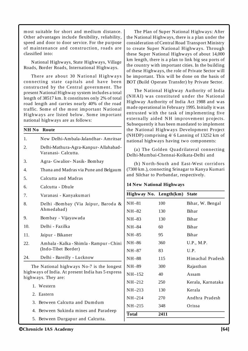
Chronicle IAS Academy [64]
most suitable for short and medium distance.Other advantages include flexibility, reliability,speed and door to door service. For the purposeof maintenance and construction, roads areclassified into:
National Highways, State Highways, VillageRoads, Border Roads, International Highways.
There are about 30 National Highwaysconnecting state capitals and have beenconstructed by the Central government. Thepresent National Highway system includes a totallength of 38517 km. It constitutes only 2% of totalroad length and carries nearly 40% of the roadtraffic. Some of the most important NationalHighways are listed below. Some importantnational highways are as follows:
NH No Route
1. New Delhi-Ambala-Jalandhar- Amritsar
2. Delhi-Mathura-Agra-Kanpur- Allahabad-Varanasi- Calcutta.
3. Agra- Gwalior- Nasik- Bombay
4. Thana and Madras via Pune and Belgaum
5. Calcutta and Madras
6. Calcutta - Dhule
7. Varanasi - Kanyakumari
8. Delhi -Bombay (Via Jaipur, Baroda &Ahmedabad)
9. Bombay - Vijayawada
10. Delhi - Fazilka
11. Jaipur - Bikaner
22. Ambala - Kalka - Shimla - Rampur - Chini(Indo-Tibet Border)
24. Delhi - Bareilly - Lucknow
The National highways No-7 is the longesthighways of India. At present India has 5 expresshighways. They are:
1. Western
2. Eastern
3. Between Calcutta and Dumdum
4. Between Sukinda mines and Paradeep
5. Between Durgapur and Calcutta.
The Plan of Super National Highways: Afterthe National Highways, there is a plan under theconsideration of Central Road Transport Ministryto create Super National Highways. Throughthese Super National Highways of about 14,000km length, there is a plan to link big sea ports ofthe country with important cities. In the buildingof these Highways, the role of Private Sector willbe important. This will be done on the basis ofBOT (Build Operate Transfer) by Private Sector.
The National Highway Authority of India(NHAI) was constituted under the NationalHighway Authority of India Act 1988 and wasmade operational in February 1995. Initially it wasentrusted with the task of implementing fiveexternally aided NH improvement projects.Subsequently it has been mandated to implementthe National Highways Development Project(NHDP) comprising 4/6 Lanning of 13252 km ofnational highways having two components:
(a) The Golden Quadrilateral connectingDelhi-Mumbai-Chennai-Kolkata-Delhi and
(b) North-South and East-West corridors(7300 km.), connecting Srinagar to Kanya Kumariand Silchar to Porbandar, respectively.
14 New National Highways
Highway No. Length(km) State
NH–81 100 Bihar, W. Bengal
NH–82 130 Bihar
NH–83 130 Bihar
NH–84 60 Bihar
NH–85 95 Bihar
NH–86 360 U.P., M.P.
NH–87 83 U.P.
NH–88 115 Himachal Pradesh
NH–89 300 Rajasthan
NH–152 40 Assam
NH–212 250 Kerala, Karnataka
NH–213 130 Kerala
NH–214 270 Andhra Pradesh
NH–215 348 Orissa
Total 2411
Chronicle IAS Academy [65]
Ports
There are 11 major ports and 148 minorworking ports in India. Major ports are the directresponsibility of the Central government whileminor ports including the intermediate ports fallin the concurrent list of the Indian Constitutionand are managed and administered by therespective maritime state governments.
Major Ports on the Western Coast : Kandla(Gujarat); Mumbai (Maharashtra); Marmagao(Goa); New Mangalore (Karnataka); Cochin(Kerala); Jawaharlal Nehru Port (Nhava Sheva,Maharashtra).
Major Ports on the Eastern Coast: Tuticorin(Tamil Nadu); Chennai (T.N.); Vishakhapatnam(Andhra Pradesh); Paradeep (Orissa) andCalcutta -Haldia (West Bengal).
Among major ports, Mumbai is the biggest.Kandla is a tidal port. Marmagao enjoys thesecond position by value of the tonnage of traffic,bulk of which is export of iron ore.Visakhapatnam is the deepest, land-locked andprotected port. Chennai has an artificial harbour.Calcutta is a riverine port. Haldia has a fullyequipped containerized berth.
Shipping: Overseas shipping has an extremelyimportant role to play in India’s internationaltrade. The country has the largest merchantshipping fleet among developing countries andranks 17th in the world in shipping tonnage.
Air Transport
The major international airports are Delhi(Indira Gandhi International Airport - Palam);Kolkata (Dum Dum, now Netaji SubhashChandra Bose International Airport); Mumbai(Santa Cruz, now Chhatrapati ShivajiInternational Airport); Chennai (Meenambakam);Amritsar International Airport; Guwahati(Lokpriya Gopinath Bordoloi InternationalAirport); Ahmedabad (Sardar Vallabhbhai PatelInternational Airport); Hyderabad (Rajiv GandhiInternational Airport); Cochin InternationalAirport; Bengaluru International Airport; GoaInternational Airport and TrivandrumInternational Airport (Thiruvana nthapuram).Besides, there are 87 aerodromes and 20 civilenclaves maintained by Civil Aviation
Department. The Civil Aviation Centre inFursatganj near Allahabad provides, among otherthings, ground training to the pilots.
Air India established in 1953 is havingbilateral air services agreement with 90 countriesas on Jan 1, 1998.
Indian Airlines started its operations from 1stAugust, 1953, with a fleet of 99 aircraft and wasthe outcome of the merger of seven formerindependent airlines, namely Deccan Airways,Airways-India, Bharat Airways, HimalayanAviation, Kalinga Air Lines, Indian NationalAirways and Air Services of India. After beinggranted permission from the Government ofIndia, on 15 July 2007, Indian Airlines and AirIndia merged and started to operate as a singleentity. A new company called National AviationCompany Ltd was registered by the governmentto amalgamate the two airlines along with theirlow-fare subsidiaries- Air India Express (of AirIndia) and Alliance Air (of Indian). Post-mergerthe new airline will be renamed as Air Indian.
Pawan Hans Limited basically provideshelicopter support services to oil sector, hillstation and remote areas. It also provides airsupport services to several customers whichincludes ONGC, Punjab, M.P., LakshadweepAdministration, GAIL, BSF and also caters toprivate sector.
Private Air Taxi: The liberalization process incivil aviation took wing in April 1990 with thecargo open skies policies.
National Waterways
The Inland Waterways Authority of India wasset up on October 27, 1986. This statutory bodyhas the responsibility of development,maintenance and regulation of nationalwaterways.
The Government has identified 10 importantwaterways for consideration to declare them asNational waterways. The followings have so farbeen declared as National Waterways and thesame are being developed for navigation byInland Waterways Authority of India.
� The Ganga between Allahabad and Haldia(1620 km) on October 27, 1986,
� The Sadia-Dhubri-stretch of river Brahmaputra(891 km) on October 26, 1988 and
Chronicle IAS Academy [66]
� The Kollam-Kottapuram stretch of westcoast canal (168 km) along with Champakaracanal (14 km) and Udyogmandal canal (22km) in Kerala
� Kakinada - Puducherry stretch of canals andthe kalu velly Tank.
� Talcher - Dhamra stretch of river Brahmani.
� Lakhipur to Bhanga of river Barak
Posts & Telegraphs
The first Indian postal stamp was issued in1852 in Karachi. The Postal department was setup in 1854 when nearly 700 post offices were
already functioning. Today, there are about1, 53,454 post offices. For the efficient and correcthandling of the volume of mail, a numerical postaladdress code, known as the Postal Index Number(PIN), was introduced with digits which help toidentify and locate every departmental deliverypost offices excluding branch post offices.
Telecommunication
Telecommunication services were introducedin India soon after invention of Telegraph andtelephone. First telegraph line between Calcuttaand Diamond Harbor was opened for traffic in1851. By March 1884, telegraph messages couldbe sent from Agra to Calcutta.
���
WORLD
GEOGRAPHY

CHRO
NICLE
IAS ACADEM
Y
[69] Chronicle IAS Academy
ASIAASIAASIAASIAASIA
Introduction
Asia is the largest of all the continents andincludes an area of 44,444,100 sq km which isabout 33 per cent of the world's total landsurface and the greater part of the Eurasianlandmass. The total population of Asia in 2001was 3,720 million, which is likely to be 4,714million in 2025 and 5,262 million in 2050. About37 percent of the total population of Asia isurban. The Asian countries are usually groupedinto five main geographical and politico-cul-tural sub-divisions:
(1) Southwest Asia, which includes Af-ghanistan, Bahrain, Cyprus, Iran, Iraq, Israel,Jordan, Kuwait, Lebanon, Oman, Qatar, SaudiArabia, Yemen plus Turkey (on both sides ofthe Sea of Marmara in Asia and Europe), andEgypt, east of Suez Canal (Sinai peninsula).
(2) South Asia, which includes Bangladesh,Bhutan, India, Maldives, Nepal, Pakistanand Sri Lanka (formerly Ceylon).
(3) Southeast Asia, which includes Brunei,Myanmar (formerly Burma), Cambodia,Indonesia, Laos, Malaysia, Philippines,Singapore, Thailand and Vietnam.
(4) East Asia, which includes China, Japan,North Korea, South Korea and Taiwan.
(5) Central Asia, which includes all of Siberiaand the Russian republics in Asia(Kazakhstan, Kirghizia, Tajikistan,Turkmenistan and Uzbekistan).
Landscape
Some of the highest, lowest and coldestplaces on Earth are found in Asia. MountEverest in the Himalayas is the highest, theDead Sea in the west is the lowest and thefrozen wastes of northern Siberia are amongthe coldest. The Northern Asia is made up ofold mountains and ancient stable plateaus. TheJagged Himalayan mountains dominate thecentral part of the continent along with the
plateau of Tibet, which stretches north intoChina. In south-east Asia, there are many is-lands. Volcanoes and earthquakes are commonand some of the islands are volcanically formed.
The Arabian peninsula and mountainousIranian plateau are divided by the Gulf, fed bythe Tigris and Euphrates rivers. Further east,the land begins to rise, the mountains spread-ing to north of the plateau of Tibet and Southof the Himalayas. The plain of the south of theHimalayas are drained by the Indus and Gangesand to the east of the plateau of Tibet the Yel-low River.
In the far north of Asia, the land is perma-nently frozen which is known as "Permafrost".Asia is watered by many great rivers. India'sGanges has its source high in the Himalayas.Tropical forests blanket the landscape acrossmuch of Southeast Asia especially in Burma,Thailand and islands of Borneo, Celebes, Javaand Sumatra. The "Takla Makan" is one of theseveral deserts in Central Asia.
Political Feature
In Asia there is the existence of varioustraditions, people and culture. The breakup ofSoviet Union, which once stretched south fromRussia to Iran produced the new Central AsianRepublic of Kazakhstan, Kyrgyzstan, Tajikistan,Turkmenistan and Uzbekistan. The countriesin southwest Asia are mainly Muslim, but aredivided by religious difference and conflict.India is the world's largest democracy whileChina is a communist power. China and NorthKorea have been governed by strict communistgovernment since the late 1940s. In 1991,people in the Soviet Union rejected commu-nism and elected the first non-communist gov-ernment after almost 70 years. During the So-viet Era, the Islamic faith and culture in Cen-tral Asia were actively suppressed.
Population
The deserts and high mountains of Asiaare almost uninhabited and much of the Rus-
CHRONICLEIAS ACADEMYA CIVIL SERVICES CHRONICLE INITIATIVE
CHRO
NICLE
IAS ACADEM
Y
[70] Chronicle IAS Academy
sian Federation is very sparsely populated.Singapore is one of the world's most denselypopulated places. Japan and India also havevery high densities. Over 20 per cent of theWorld's people live in China but India is fastcatching up.
Industry
Agricultural occupation is still dominatingaround the continent. Heavy industry domi-nated eastern China and Russia, but Japan isthe most industrially productive country. Inrecent years booming 'tiger' economies have de-veloped in countries such as Taiwan whichborders the Pacific Ocean. Norilsk is one ofseveral Soviet Era industrial complexes built inRussia. It is the processing centre for rich min-erals reserve found nearby.
Japan is a world-leading producer of elec-tronic and high-tech goods like computer, cam-eras and hi-fi equipment. Taiwan, South Koreaand Singapore also produce electronic goods.
Mineral Resources
Over half of the world's oil gas reserves arein Asia, most importantly found in Gulf and inWestern Siberia. Coal in Siberia has providedpower for steel industries. Metallic minerals arealso abundant. Tin is found in southeast Asiaand Platinum and Nickel in Siberia. The dis-covery of oil in the Gulf has generated enor-mous wealth and produced rapid industrial andsocial change in the countries such as SaudiArabia, U.A.E. and Kuwait which control theoil supplies.
Climate
The continental type of climate is preva-lent in most part of the Asia, apart from thecoastal areas. Without the moderating effect ofthe Ocean temperature can soar during the dayand plummet at night, while rainfall is gener-ally low producing several large deserts. Tem-perature as low as -68°C have been recordedin the frozen wastes of Siberia while the is-lands in Southeast Asia have tropical climates.Southern and Eastern Asia are also affected bya seasonal wind called the Monsoon. This origi-nates in the Indian Ocean and brings heavyrainfall and high winds.
Land-Use and Agriculture
The large expanses of Asia are uncultivated
because the soil is too poor or the climate is toocold or dry for crops to grow. The plateau ofTibet, much of Siberia and Arabian Peninsulahave limited agriculture. Some of the most fertileland is found in eastern China and India, whererice is a staple. Elsewhere cash-crops are grownfor profit, such as dates in southwest Asia, tea inIndia, China and Sri Lanka and coconutsthroughout the island archipelago of SoutheastAsia. China is the world's largest producer ofrice, where it is grown in muddy fields calledpaddy fields. Uzbekistan is the world's fourth larg-est producer of cotton.
South West Asia
Landscape
It chiefly consists of the countries likeBahrain, Iran, Iraq, Israel, Jordan, Kuwait,Lebanon, Oman, Qatar, Saudi Arabia, Syria,United Arab Emirates and Yemen. Much ofthe Southwest Asia is covered with sandy androcky deserts. On the vast Arabian Peninsulawhich covers an area almost the size of India-narrow, sandy plains along the Red Sea andthe south-coast rise to dry mountains. In thecentre is a vast high plateau that slopes gentlydown to the flat shores of the Gulf. The moun-tainous area of Iran experience frequent earth-quakes.
The 'Wadis', a type of valley and riverbedsare found in Saudi Arabian desert. Usually theyare dry, but after heavy rains, they are brieflyfilled by fast flowing rivers. The Syrian desertextends from the Jordon Valley in the west tothe fertile plains of the Tigris and Euphratesrivers in the East. It is mainly a rocky desert, asthe sand has been swept away by winds andoccasional heavy rainstorms. Oases are areaswithin a desert where water is available forplants and human use. They are usually formedwhen a fault, or split in the rock allows waterto come to surface. The Dead Sea is the largelake on the border between Israel and Jordon.It is the lowest point on the earth's surface. Itsshores lie 392 m below sea level. It is also theworld's saltiest body of the water and can sup-port no life forms. The Rub-al-khali desert, alsoknown as ‘Empty Quarter’ is the largest unin-terrupted stretch of sand on Earth. It coverssome 650,000 sq.km. and is one of the world'sdriest and most-hostile deserts. The Iranian pla-teau in Central Iran is a vast semi-arid plateau,
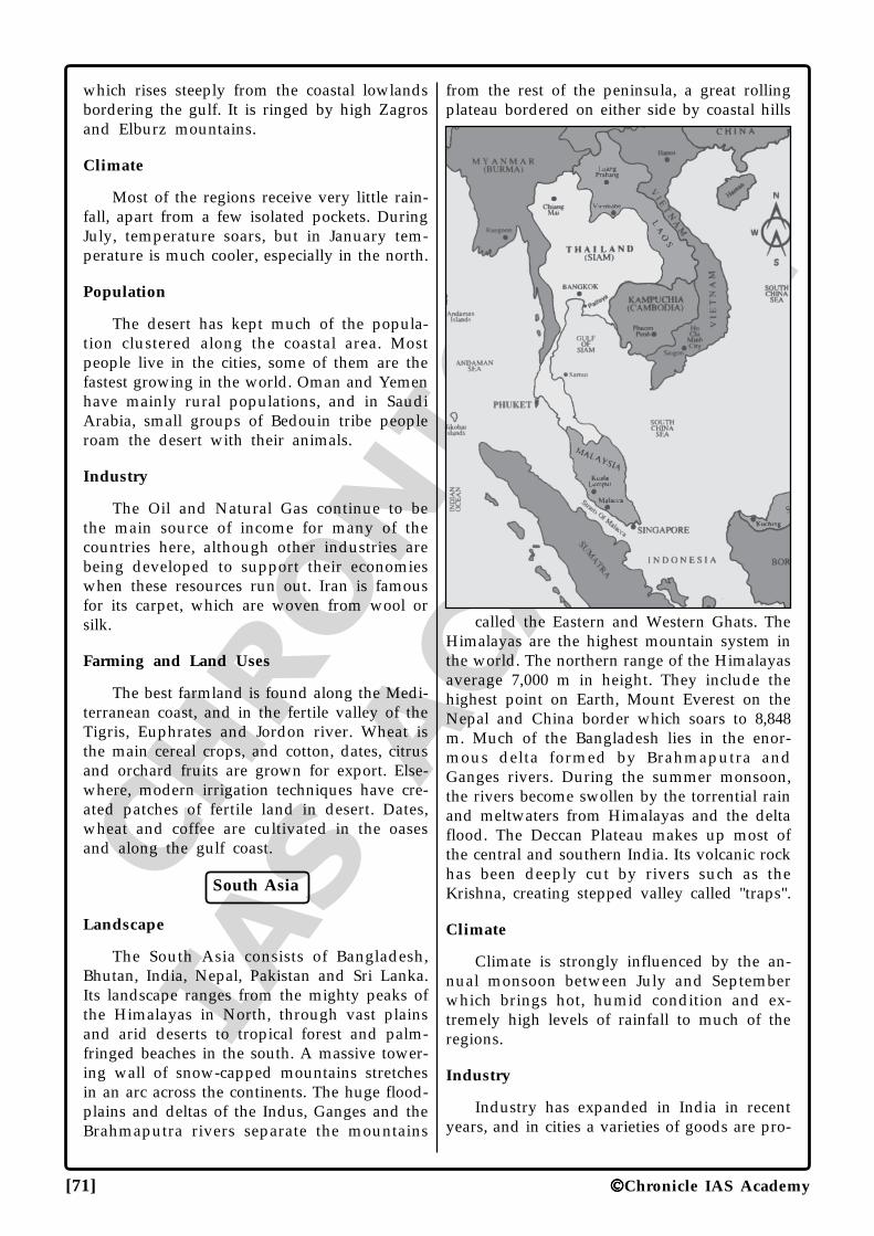
CHRO
NICLE
IAS ACADEM
Y
[71] Chronicle IAS Academy
which rises steeply from the coastal lowlandsbordering the gulf. It is ringed by high Zagrosand Elburz mountains.
Climate
Most of the regions receive very little rain-fall, apart from a few isolated pockets. DuringJuly, temperature soars, but in January tem-perature is much cooler, especially in the north.
Population
The desert has kept much of the popula-tion clustered along the coastal area. Mostpeople live in the cities, some of them are thefastest growing in the world. Oman and Yemenhave mainly rural populations, and in SaudiArabia, small groups of Bedouin tribe peopleroam the desert with their animals.
Industry
The Oil and Natural Gas continue to bethe main source of income for many of thecountries here, although other industries arebeing developed to support their economieswhen these resources run out. Iran is famousfor its carpet, which are woven from wool orsilk.
Farming and Land Uses
The best farmland is found along the Medi-terranean coast, and in the fertile valley of theTigris, Euphrates and Jordon river. Wheat isthe main cereal crops, and cotton, dates, citrusand orchard fruits are grown for export. Else-where, modern irrigation techniques have cre-ated patches of fertile land in desert. Dates,wheat and coffee are cultivated in the oasesand along the gulf coast.
South Asia
Landscape
The South Asia consists of Bangladesh,Bhutan, India, Nepal, Pakistan and Sri Lanka.Its landscape ranges from the mighty peaks ofthe Himalayas in North, through vast plainsand arid deserts to tropical forest and palm-fringed beaches in the south. A massive tower-ing wall of snow-capped mountains stretchesin an arc across the continents. The huge flood-plains and deltas of the Indus, Ganges and theBrahmaputra rivers separate the mountains
from the rest of the peninsula, a great rollingplateau bordered on either side by coastal hills
called the Eastern and Western Ghats. TheHimalayas are the highest mountain system inthe world. The northern range of the Himalayasaverage 7,000 m in height. They include thehighest point on Earth, Mount Everest on theNepal and China border which soars to 8,848m. Much of the Bangladesh lies in the enor-mous delta formed by Brahmaputra andGanges rivers. During the summer monsoon,the rivers become swollen by the torrential rainand meltwaters from Himalayas and the deltaflood. The Deccan Plateau makes up most ofthe central and southern India. Its volcanic rockhas been deeply cut by rivers such as theKrishna, creating stepped valley called "traps".
Climate
Climate is strongly influenced by the an-nual monsoon between July and Septemberwhich brings hot, humid condition and ex-tremely high levels of rainfall to much of theregions.
Industry
Industry has expanded in India in recentyears, and in cities a varieties of goods are pro-
CHRO
NICLE
IAS ACADEM
Y
[72] Chronicle IAS Academy
duced and processed, including cars,aeroplanes, chemicals, food and drink. Servicesindustries such as tourism and banking are alsogrowing elsewhere. Small scale cottage indus-try serve the need of local people, but manyproduct, mainly silk and cotton textiles, cloth-ing leather and jewellery are also exported.
Population
Most of the South Asia's people live in vil-lages scattered across the fertile river floodplainsin mountain valley or along the coast, but in-creasing number are migrating to the cities insearch of work. Overcrowding is a serious prob-lem in both rural and urban areas. In manycities thousands of people are forced to live inslums or on streets.
Farming and Land Use
Over 60 per cent of the population involvedin agriculture, but most farmers are small andproduce only enough food to feed the family.Grains are the staple food crop- rice is grownin the wetter parts of the east and west, cornand millet on the Deccan Plateau, and wheatin north. Groundnuts are widely grown as asource of cooking oil. Cash crops include teaand jute.
South East Asia
South East Asia chiefly consists of the coun-tries like Brunei, Cambodia, Indonesia, Laos,Malaysia, Myanmar, Philippines, Singapore,Thailand, Vietnam. On the mainland, a belt ofmountain range clocked in thick forest, runnorth-south. The mountains are cut throughby the wide valley of five great rivers. On theirroute to sea, these rivers have deposited sedi-ments forming immense, fertile flood plains anddeltas. To the southeast of the mainland lieshuge arc of over 20,000 mountainous volcanicislands. "Borneo" is the world's third largestislands with total area of 757,000 km. Lying onthe Equator and in the path of two monsoon,the island is hot and one of the wettest placeson the Earth. The Mekong river flows throughsouthern China and Myanmar and forms muchof the border between Laos and Thailand. Itthen travels through Cambodia before endingin a vast delta on the southern coast of Viet-nam, that is one of the world's most produc-tive rice growing area. Indonesia is the world'smost active volcanic region of the world. Java
alone has over 50 active volcanoes out of thecountry's total of more than 220. The Philip-pines' 7000 islands are mountainous and vol-canic with narrow coastal plains. Irian Java isa province of Indonesia. Its dense rainforestsare some of the lasts unexplored areas on theEarth and are inhabited by many rare plantsand animal species. Indonesia is an archipelagoof 13,677 islands, scattered over almost 5,000km. The islands lie on the boundary betweentwo of the Earth's tectonic plates and frequentlyexperience earthquakes.
Climate: The Southeast Asia's climate isstrongly affected by the Monsoon which bringswarm humid air and high rainfall to mainlandSoutheast Asia during July and to maritimeSoutheast Asia during January.
Industry
Industries based on the processing of rawmaterials like Metallic mineral, timber, oil andgas and agricultural produce, are importanthere but manufacturing has grown dramati-cally in recent years. Many foreign firms at-tracted by low labour cost, have invested inthe region. Malaysia and Singapore are majorproducers of electronic goods like disk drivesfor computers.
Farming and Land Use
The staple crop here is rice which grows inlow-lying flooded fields called Paddies, or onterraces cut into the hillside. Sugarcane, coco-nut, bananas and pineapples are widely grownas cash crops and Malaysia produces 25% ofthe World's rubber. Freshwater and Marine fishare caught in large quantities. Fish is one of themain foods in the region.
Population
The population is chiefly concentrated inthe river valley, plateaus or plains. Uplandareas are inhabited by small groups of hillspeoples. Most people still live in rural areas,but the cities are growing fast. In Indonesiaand Philippines, the population is unequallydistributed. Some islands such as Java aredensely settled.
East Asia
Landscape
It mainly consists of China, Mongolia and
CHRO
NICLE
IAS ACADEM
Y
[73] Chronicle IAS Academy
Taiwan. China's landscape divides into threeareas. The vast plateau of Tibet in the south-west is the highest and largest plateau on Earth.It contains both dry deserts and pockets ofpasture surrounded by high mountains. North-west China has dry highlands. The great plainsof eastern China were formed from soil depos-ited by rivers like the Yellow river over thou-sands of years. Most of Mongolia is dry grass-land, steppe and cold arid deserts. The aridlandscape of the Gobi and Takla Makan desertare made up of bare rock surface and hugeareas of shifting sand dunes. They are hot inthe summer, but unlike most other deserts, areextremely cold in winter. In the farming areasof Eastern and Southern China, terraces havebeen carved into the hillside to make them flatenough to grow rice and other crops. "The TienShan Mountain" or "Heavenly Mountain"reaches a height of 7,435 m. They surroundfields of permanent ice and spectacular gla-ciers. The Roof of the World or cold remoteplateau of Tibet has 4,000 m average height.Many of China's great rivers have their sourceshere. The world's highest human settlement atown called Wenquan is found in the east ofthe plateau. It lies 5,099 m above the sea level.
Climate
Two air masses control climate, one coldand dry from Siberia and one moist and dryfrom Pacific. Winters are long and cold awayfrom the coast- especially on the plateau ofTibet.
Industry
Chemicals, iron and steel, engineering andtextile are the main industries in China's eastcoast cities and in industrial centres likeShenyang. Shanghai, Hong Kong and Beijingare also financial centres. In the interior largedeposit of coal support the heavy industries inmajor cities such as Chengdu and Wuhan.Taiwan specializes in textile and shoe manu-facture, along with electronic goods. Mongolia'seconomy is mainly agricultural.
Population
Most of the China's people live in the east-ern part of the country where the climate, land-scape and soils are most favourable. Urbanareas cover the houses of over 250 millionpeople, but almost 75% of the population lives
in villages and farm the land. Taiwan's low-lands are very densely populated. In Mongolia,about 50 per cent of the people live in thecountryside.
Farming and Lane Use
About the 90 per cent of China is unsuit-able for farming. Either the soil and climate arepoor, or the landscape is too mountainous. Inthe North and West, most farmers make theirliving by herding animals. On the fertile east-ern plain, soyabean, wheat corn and cottonare grown. Further south, rice becomes the maincrops and pigs are raised in large number.
The three Gorge hydro-electric scheme onthe Yangtze River will be the world's largest.
Japan And Korea
Landscape
It chiefly consists of Japan, North Koreaand South Korea. Japan is curved chain of 4,000islands in the Pacific Ocean. It is covered byforested mountains and hills, fast flowing riv-ers and small lakes. Only about a quarter ofthe land is suitable for building and farmingand new land has been created by cutting backhillsides and reclaiming land from the sea. TheNorth and South Korea are mostly mountain-ous, with some coastal plains. Japan's four mainislands- Hokkaido, Honshu, Shikoku andKyushu were formed when two giant platesmaking up the Earth's crust collided makingtheir edge buckle upward. T'aebeak-Sanmaek,a wooded mountain range forms the backboneof the Korean Peninsula. It runs from north tosouth close to the east coast. Huge sea-wavescalled "Tsunamis" frequently threaten the eastcoast of Japan. They are set off by submarineearthquakes. In Japan, earthquakes are partsof everyday life. The islands lie on a fault lineand earthquake tremours occur, on average5,000 times a year. Japan's mountain rangesare studded with volcanoes, 60 of which arestill active. Mount Fuji is a 3,776 m snowcapped volcano and the highest mountain inJapan. It last erupted in 1707.
Climate
Korea has hot summer and dry, very coldwinters especially in the North, where snow isvery common. In Japan winters are less coldand in the Asian mainland summer are hot,
CHRO
NICLE
IAS ACADEM
Y
[74] Chronicle IAS Academy
wet and humid.
Industry
Japan is the world leader in hi-tech elec-tronic goods like computers, televisions andcameras as well as cars. South Korea also hasa thriving economy. It produces ships, cars, hi-tech goods, shoes and clothes for worldwideexport. Both countries have to import most oftheir raw materials and energy. North Koreahas little trade with other countries but it isrich in minerals and energy.
Population
Approximately about 125 million people livein crowded cities on the coast of the four mainislands. The Kanto plain around Tokyo isJapan's biggest area of flat land, and most ofthe populous part of the country. In SouthKorea, a quarter of the population lives in capi-tal Seoul. Most North Koreans live on thecoastal plains.
Farming and Land Use
The method of farming allows Japan togrow much of its own food, despite a shortageof farmland. Rice is the main crops grownthroughout the region. Japan has a large fish-ing fleet. The Japanese eat more fish than anyother nation. In North Korea farming is con-trolled by the government.
Central Asia
Landscape
Central Asia consists of the countries likeAfghanistan, Kyrgyzstan, Tajikistan,Turkmenistan and Uzbekistan. It is a land ofhot, dry deserts and high rugged mountains.Two of the world's great deserts, the Kara Kumand Kyzyl Kum cover much of the Westernportions of Central Asia. In the east, a belt ofhigh mountain ranges- the Hindu Kush, TheTien Shan and the Pamirs- tower above theland. Few rivers cross the deserts, apart fromAmu Darya which flows from the Pamir to theshrinking Aral Sea. The Aral Sea was once thefourth largest lake in the World, but it hasshrunk by 40% since 1960. Diversion of its waterfor irrigation has made the lake shallower, soits water evaporates faster. The sandy desert ofKara Kum occupies over 70%, of Turkmenistan.Its surface consists of wind sculpted dunes and
depressions. The stress and strain in the Earthcreated the Fergana Valley, a deep depressionencircled high mountains. The valley's fertilesoil is irrigated by water from the Darya Riverand underground source. Pamir lies mainly inTajikistan. Their highest point at 7,495 m isCommunism Peak, so named because it wasthe highest peak in former Soviet Union.
Climate
Central Asian climate is strongly influencedby the position deep within Asia, far from themoderating effects of the ocean, winters arecold and summers are hot everywhere. Rain-fall is virtually non-existent all year around.
Industry
The fossil fuel especially coal, natural gasand oil are extracted and processed through-out Central Asia. Agriculture supplies the rawmaterial for many industries including food andtextile processing and the manufacture ofleather goods and clothing. The region is fa-mous for its colourful traditional carpets, handwoven from the wool of Karakul Sheep. The"Fargana Valley" of southeast of Tashkent isthe main industrial area.
Population
Most of the people of Central Asia are ruralfarmers living in the river valley and in oases.There are few larger cities. A few still lead atraditional nomadic lifestyle, moving from placeto place with their animals in search of newpastures. Large area of Afghanistan and west-ern deserts and mountain regions in the eastare virtually uninhabited.
Farming and Land-Use
Farming is concentrated around the fertileriver valley. A variety of cereals and fruits in-cluding peaches, melons and apricots aregrown. In drier areas, animal breeding is im-portant, with goats, sheep and cattle supply-ing wool, meat and hides. Big crops of cotton,which is a major export, are produced on landirrigated by the Amu Darya River.
Russia
Landscape
To the east of the Ural Mountains lies the
CHRO
NICLE
IAS ACADEM
Y
[75] Chronicle IAS Academy
West Siberian Plain-the world's biggest area offlat ground. The plain gradually rises to theCentral Siberian Plateau, and again to high-lands in southeast. Great coniferous forest calledTaiga, stretcher across most of these lands. Thefar north of Siberia extends into the ArcticCircle. There, the landscape is made up of fro-zen plains called "Tundra". Much of theKazakhstan is covered by huge rolling grass-lands or Steppes; in the south are arid sandydeserts. The Tundra and Taiga are stubby birchtrees, dwarf bushes, moss and lichen huddleclose to the ground in frozen Tundra wastes ofNorthern Russia. They lie between the perma-nent ice and snow of the Arctic, and the thickTaiga forests which covers an area greater thanthe Amazon rainforest. The Caspian Sea cov-ers 371,000 sq. km and is the world's largestexpanse of inland water. It is fed by the Volgaand Ural rivers which flow in from the plainsof the north. The West Siberian Plain is cov-ered with a network of mashes and streams.The Ob rivers which winds its way north acrossthe plain, is frozen for up to half the year.Lake Baikal is the deepest lake in the worldand the largest freshwater one; it is more than1.6 km deep and covers 32,500 sq. km. It is fedby 336 rivers and contains around 20% of allfresh water in the world.
Farming and Land-Use
The harsh climate of Siberia has restrictedfarming to the south where there are a fewareas. Warm enough to grow cereals crops, suchas wheat and oats, and to raise cattle on thesmall pocket of pasture. The rest of the regionis used for hunting, herding Reindeer and for-estry- the Taiga forests contains the world'sbiggest timber reserves. In Kazakhstan, bigherds of cattle, goats and sheep are raised forwool and meat and wheat is cultivated in fer-tile north.
Climate
Russia and Kazakhstan have strongly con-tinental climate and their distance away fromsea and ocean means that temperature fluctu-ates wildly both daily and seasonally. Tempera-ture in eastern Siberia has been known to reach-68°C.
Population
Siberia has some of the world's largest area
of uninhabited land. The bitingly cold climateand harsh living conditions have kept the popu-lation small. The industrial cities in the Westhold the most people. Despite its huge sizeKazakhstan has only 17 million people; mostof whom live in urban areas.
Points To Remember
• Asia is the world's largest peak conti-nent.
• Mount Everest in the Himalayas is thehighest in the world.
• The Dead Sea in the West is the lowestpoint in the world.
• The coldest point in Asia is the frozenwaste of Northern Siberia.
• Himalayas is the example of youngmountain range.
• The 'Takla Makan' is one of severaldeserts in the Central Asia.
• Singapore is one of the world's denselypopulated places.
• India is the world's largest democracywhile China is a communist power.
• The booming 'Tiger Economy' has de-veloped in countries such as Taiwanwhich borders the Pacific Ocean.
• Norilsk is one of several era industrialcomplexes built in Russia. It is a pro-cessing centre of rich minerals reservesfound nearby.
• Mumbai is India's leading industrial cityand has a thriving stock market.
• Half of the world's oil and gas reservesare in Asia.
• Japan is world's leading producer ofelectronic and high-tech goods like com-puters, cameras and equipment.
• Uzbekistan is world's fourth largest pro-ducer of cotton.
• China is World's largest producer of rice.
• Tropical climate across the island ofSoutheast Asia produces warm humidcondition in which rainforest are found.
• The deepest lake in the world is the Lake
CHRO
NICLE
IAS ACADEM
Y
[76] Chronicle IAS Academy
Baikal and it is also the largest freshwater one.
• The Taiga forests of Siberian region con-tain the world's biggest timber reserves.
• Lake Van is one of the shallow salt lakesfound in Anatolia.
• The Syrian Desert is mainly rocky whichextends from the Jordan valley in thewest to fertile plains of the Tigris.
• The Dead Sea is situated between theborder of Israel and Jordan.
• The Bedouin tribe is found in SaudiArabia.
• The Wadis is a type of river bed andvalley.
• The continent of Asia consists of 60 percent of the world population.
• The alluvial river valley of the Ganges(in India) and the Yangtze and HuangHo (in China) have the greatest popula-tion densities of the world.
• The type of Agriculture which is com-monest in Asia in known as intensiveagriculture.
• More than 90 per cent of the world'srice is grown in Asia.
• Coniferous forests are found in SovietUnion, Japan and Himalayan region.
• Monsoon forest is found in Myanmarand parts of south-east-Asia.
• Equatorial forests are found in Malaysiaand Indonesia.
• Malaysia is the largest producer and ex-porter of rubber in the world.
• Victoria is the capital of Hong Kong.
• East Timor is an island situated betweenIndonesia and Australia in the TimorSea.
• Tsunamis are a type of sea waves whichfrequently threaten the east coast of Ja-pan.
• Mount Fuji is a 3,776 m snow-cappedvolcano and the highest mountain inJapan.
• The Gobi and Takla Makan desert arehot in summer and extremely cold inwinter.
• The plateau of Tibet is known as theroof of the world.
• The arid and sandy Thar deserts liesbetween the border of India and Paki-stan.
• Mekong River flows through SouthernChina and Myanmar and forms muchof the border between Laos and Thai-land.
• Indonesia is most active volcanic regionof the world.
• Irian Jaya is a province of Indonesia. Itsdense rainforest are some of the lastsunexplored areas on the Earth and areinhabited by many rare plant and ani-mal species.
•••
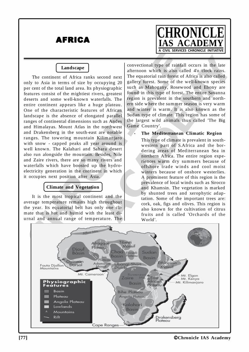
CHRO
NICLE
IAS ACADEM
Y
[77] Chronicle IAS Academy
AFRICAAFRICAAFRICAAFRICAAFRICACHRONICLEIAS ACADEMYA CIVIL SERVICES CHRONICLE INITIATIVE
Landscape
The continent of Africa ranks second nextonly to Asia in terms of size by occupying 20per cent of the total land area. Its physiographicfeatures consist of the mightiest rivers, greatestdeserts and some well-known waterfalls. Theentire continent appears like a huge plateau.One of the characteristic features of Africanlandscape is the absence of elongated parallelranges of continental dimensions such as Andesand Himalayas. Mount Atlas in the northwestand Drakensberg in the south-east are notableranges. The towering mountain Kilimanjarowith snow - capped peaks all year around iswell known. The Kalahari and Sahara desertalso run alongside the mountain. Besides, Nileand Zaire rivers, there are so many rivers andwaterfalls which have boosted up the hydro-electricity generation in the continent in whichit occupies next position after Asia.
Climate and Vegetation
It is the most tropical continent and theaverage temperature remains high throughoutthe year. Its equatorial belt has only one cli-mate that is hot and humid with the least di-urnal and annual range of temperature. The
convectional type of rainfall occurs in the lateafternoon which is also called 4'o clock rains.The equatorial rain forest of Africa is also calledgallery forest. Some of the well-known speciessuch as Mahogany, Rosewood and Ebony arefound in this type of forest. The entire Savannaregion is prevalent in the southern and north-ern side where the summer season is very warmand winter is warm. It is also known as theSudan type of climate. This region has some ofthe largest wild animals thus called 'The BigGame Country'.
• The Mediterranean Climatic RegionThis type of climate is prevalent in south-western part of S.Africa and the bor-dering areas of Mediterranean Sea innorthern Africa. The entire region expe-riences warm dry summers because ofoffshore trade winds and cool moistwinters because of onshore westerlies.A prominent feature of this region is theprevalence of local winds such as Siroccoand Khamsin. The vegetation is markedby shunted trees and xerophytic adap-tation. Some of the important trees are:cork, oak, figs and olives. This region isalso known for the cultivation of citrusfruits and is called 'Orchards of theWorld'.
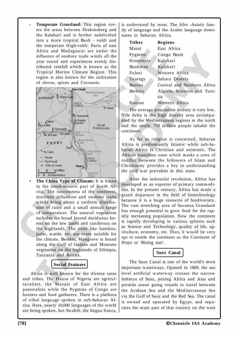
CHRO
NICLE
IAS ACADEM
Y
[78] Chronicle IAS Academy
• Temperate Grassland: This region cov-ers the areas between Drakensberg andthe Kalahari and is further subdividedinto a more tropical Bush - veldt andthe temperate High-veldt. Parts of eastAfrica and Madagascar are under theinfluence of onshore trade winds all theyear round and experiences evenly dis-tributed rainfall which is known as theTropical Marine Climate Region. Thisregion is also known for the cultivationof cloves, spices and Coconuts.
• The China Type of Climate: It is foundin the south-eastern part of South Af-rica. The narrowness of the continent,maritime influences and onshore tradewinds bring about a uniform distribu-tion of rains and a small annual rangeof temperature. The natural vegetationincludes the broad leaved deciduous for-ests on the low lands and coniferous onthe highlands. The trees like bamboo,palm, wattle, etc. are more suitable forthe climate. Besides, Mangrove is foundalong the Gulf of Guinea and Montanevegetation on the highlands of Ethiopia,Tanzania and Kenya.
Social Features
Africa is well known for the diverse racesand tribes. The Hausa of Nigeria are agricul-turalists, the Masais of East Africa arepastoralists while the Pygmies of Congo arehunters and food gatherers. There is a plethoraof tribal language spoken in sub-Saharan Af-rica. Here, nearly 10,000 languages of the worldare being spoken, but Swahili, the lingua franca,
is understood by most. The Afro -Asiatic fam-ily of language and the Arabic language domi-nates in Saharan Africa.
Tribes RegionsMasai East AfricaPygmies Congo BasinHottentots KalahariBushman KalahariFulani Western AfricaTuaregs Sahara DesertsBantus Central and Southern AfricaBerbers Algeria, Morocco and Tuni-
siaHausas Western Africa
The average population density is very low.Nile delta is the high density area accompa-nied by the Mediterranean regions in the northand the south. 750 million people inhabit thecontinent.
As far as religion is concerned, SaharanAfrica is predomiantly Islamic while sub-Sa-haran Africa is Christian and animistic. TheAfrican transition zone which marks a zone ofconflict between the followers of Islam andChristianity provides a key to understandingthe civil war prevalent in this zone.
After the industrial revolution, Africa hasdeveloped as an exporter of primary commodi-ties. In the present century, Africa has made agrand departure in the field of biotechnologybecause it is a huge resource of biodiversity.The vast stretching area of Savanna Grasslandhas enough potential to grow food for the rap-idly increasing population. Now the continentis rapidly developing in various spheres suchas Science and Technology, quality of life, ag-riculture, economy, etc. Thus, it would be veryapt to entitle the continent as the Continent ofHope or 'Rising star'.
Suez Canal
The Suez Canal is one of the world's mostimportant waterways. Opened in 1869, the sealevel artificial waterway crosses the narrowIsthmus of Suez, joining Africa and Asia andpermits ocean going vessels to travel betweenthe Arabian Sea and the Mediterranean Seavia the Gulf of Suez and the Red Sea. The canalis owned and operated by Egypt, and sepa-rates the main part of that country on the west
CHRO
NICLE
IAS ACADEM
Y
[79] Chronicle IAS Academy
bank from the Sinai Peninsula on the east bank.The northern terminus of the canal is Port Said.Southward, the canal continues in a straightline through Manzala and Timshah lakes andIsmailia where the administrative headquartersof the canal is located. Further south the canalpasses through the Great and Little Bear lakes(now a single lake) and then passes throughthe city of Suez.
Minerals of Africa
Minerals Leading Producers1. Gold South Africa2. Petroleum Nigeria3. Iron ore South Africa4. Diamond Zaire5. Manganese South Africa6. Phosphate Morocco7. Tungsten Zaire8. Bauxite Guinea9. Copper Zaire10. Platinum South Africa11. Chromium South Africa12. Vanadium South Africa13. Antimony South Africa
Mines Minerals
1. Kimberley Diamonds2. Lubumbashi Copper3. Wankie Coal4. Witwatersrand Gold5. Katanga Copper & Cobalt6. Kasai Province Bort Diamond
Old Name New Name
1. Zaire Democratic Republic ofCongo
2. Katanga Shaba3. Elizabethville Lubumbashi4. Gold Coast Ghana5. South -West Africa Namibia6. Leopoldville Kinshasa7. South Rhodesia Zimbabwe8. North Rhodesia Zambia9. Nyasaland Malawi10. Stanleyville Kisangani
Agricultural Product Leading Producer
1. Rubber Liberia
2. Tea Kenya
3. Coffee Liberia
4. Oil palm Nigeria
5. Cocoa Ghana
6. Cloves Zanzibar
7. Sisal Tanzania
8. Wool S.Africa
9. Maize S.Africa
10.Cotton Egypt
11.Wheat S. Africa
Points to Remember
1. Sirocco is a type of hot wind blowing fromSahara to Mediterranean.
2. Swahili is the oldest surviving African lan-guage.
3. The country Zaire has the maximum Hydro-electric Power potential in Africa.
4. The country Djibouti is facing the Strait ofBab-el-Mandeb.
5. Dar-es-Salam is the easternmost terminus ofTanjara railways which begins fromKatanga mineral belt.
6. Ostrich is the flightless bird of KalahariDesert.
7. Ethiopia is the place of origin of coffee.
8. Pretoria is the administrative capital of S.Africa.
9. Nilots are the aborigines of upper Nile.
10. River Zaire is the only river that crosses theequator twice.
11. Nubian desert lies in Egypt.
12. The countries Ethiopia and Somalia formthe Horn of Africa.
13. High Veld is the temperate grassland ofSouth Africa.
14. Africa is the most tropical of all continents.
15. Most part of Kalahari Desert lies in Botswana.
16. The Farmers of the Egypt are also calledFellahin.
17. Gibraltar, Suez and Bab-el-Mandeb are threepoints where Africa almost touches Eurasia.
18. Cape of Agulhas is the southernmost tip of
CHRO
NICLE
IAS ACADEM
Y
[80] Chronicle IAS Academy
Africa.
19. Mt Kilimanjaro is the highest peak in Africa.
20. Teff is the highly nutritious crop of Ethio-pian high lands.
21. Bab-el-Mandeb is called Gate of Tears.
22. Tanzania, Kenya and Uganda are the bor-dering countries of Lake Victoria.
23. Khartoum is the city at the confluence of theBlue and the White Nile.
24. Al-Aziziya of Libya is the hottest place inthe world.
25. Morocco, Algeria and Tunisia are the threeMaghreb Republics.
26. Tana is the source of Blue Nile while Victoriais the source of White Nile.
27. The 'Great Bitter' and Little Lake are alongthe Suez Canal.
28. Zaire is a large geographically disadvan-taged state.
29. Lake Assal, Djibouti is the lowest point inAfrica.
30. Tuaregs is the nomadic herders of Sahara.
31. The Lake Victoria in East Africa is not layingin the Great Rift Valley.
32. Lake Chad is the region of inland drainage.
33. Cape Town is the seat of legislature of S.Africa.
34. The Rain Forest is the natural region withgreatest biodiversity.
35. The South African farmer of Dutch descentis called Boer.
36. Lourenco Marques was renamed as Maputo.
37. A new country Eritrea was carved out ofEthiopia during 1990s.
38. River Orange is a boundary between S.Africaand Namibia.
39. Masai is the pastoral tribe of Kenya.
40. In Africa, the best quality iron-ore (magne-tite) is found in Liberia.
41. Witwatersrand is famous for Gold.
42. Kimberly is famous for diamond.
43. Victoria Falls was discovered by Livingstone.
44. The countries Ethiopia and Liberia of Africawere never colonized.
45. Victoria Falls is on river Zambezi.
46. Victoria Falls is the largest water falls in theworld.
47. Akosombo dam is situated on the riverVolta.
48. River Limpopo is the boundary between theSouth Africa and Botswana.
49. Lake Nasser is on River Nile.
50. Harmattan is hot local wind blowing formSahara to Guinea Coast.
51. Abuja and Dodoma is the new capital ofNigeria and Tanzania.
52. South Africa is the island of Gold andDiamonds.
53. Four largest countries in decreasing order ofarea are Sudan - Algeria - Zaire - and Libya.
54. Nigeria is the land of oil palm.
•••
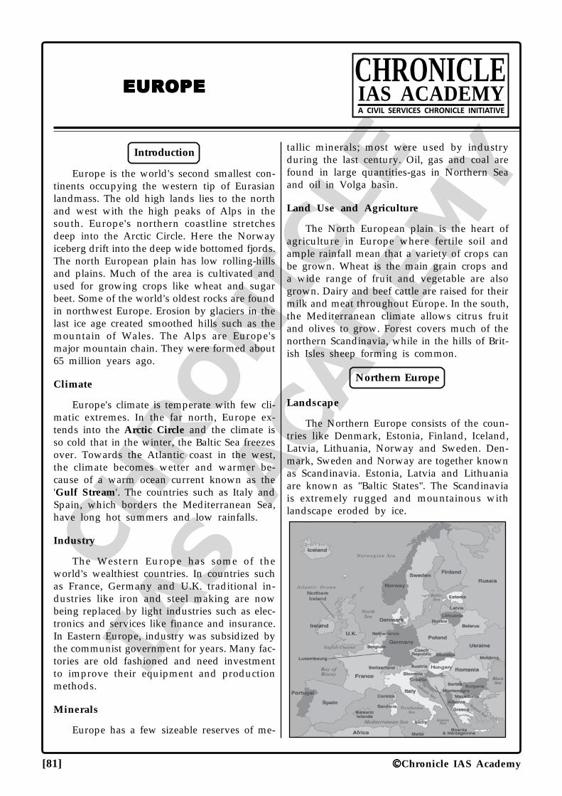
CHRO
NICLE
IAS ACADEM
Y
[81] Chronicle IAS Academy
EUROPEEUROPEEUROPEEUROPEEUROPECHRONICLEIAS ACADEMYA CIVIL SERVICES CHRONICLE INITIATIVE
Introduction
Europe is the world's second smallest con-tinents occupying the western tip of Eurasianlandmass. The old high lands lies to the northand west with the high peaks of Alps in thesouth. Europe's northern coastline stretchesdeep into the Arctic Circle. Here the Norwayiceberg drift into the deep wide bottomed fjords.The north European plain has low rolling-hillsand plains. Much of the area is cultivated andused for growing crops like wheat and sugarbeet. Some of the world's oldest rocks are foundin northwest Europe. Erosion by glaciers in thelast ice age created smoothed hills such as themountain of Wales. The Alps are Europe'smajor mountain chain. They were formed about65 million years ago.
Climate
Europe's climate is temperate with few cli-matic extremes. In the far north, Europe ex-tends into the Arctic Circle and the climate isso cold that in the winter, the Baltic Sea freezesover. Towards the Atlantic coast in the west,the climate becomes wetter and warmer be-cause of a warm ocean current known as the'Gulf Stream'. The countries such as Italy andSpain, which borders the Mediterranean Sea,have long hot summers and low rainfalls.
Industry
The Western Europe has some of theworld's wealthiest countries. In countries suchas France, Germany and U.K. traditional in-dustries like iron and steel making are nowbeing replaced by light industries such as elec-tronics and services like finance and insurance.In Eastern Europe, industry was subsidized bythe communist government for years. Many fac-tories are old fashioned and need investmentto improve their equipment and productionmethods.
Minerals
Europe has a few sizeable reserves of me-
tallic minerals; most were used by industryduring the last century. Oil, gas and coal arefound in large quantities-gas in Northern Seaand oil in Volga basin.
Land Use and Agriculture
The North European plain is the heart ofagriculture in Europe where fertile soil andample rainfall mean that a variety of crops canbe grown. Wheat is the main grain crops anda wide range of fruit and vegetable are alsogrown. Dairy and beef cattle are raised for theirmilk and meat throughout Europe. In the south,the Mediterranean climate allows citrus fruitand olives to grow. Forest covers much of thenorthern Scandinavia, while in the hills of Brit-ish Isles sheep forming is common.
Northern Europe
Landscape
The Northern Europe consists of the coun-tries like Denmark, Estonia, Finland, Iceland,Latvia, Lithuania, Norway and Sweden. Den-mark, Sweden and Norway are together knownas Scandinavia. Estonia, Latvia and Lithuaniaare known as "Baltic States". The Scandinaviais extremely rugged and mountainous withlandscape eroded by ice.
CHRO
NICLE
IAS ACADEM
Y
[82] Chronicle IAS Academy
In the South of Scandinavia, the land is flatter,with fertile soil deposited by glaciers. Much ofFinland, Norway and Sweden is covered bydense forest. The Baltic States are much lowerwith rounded hills and many lakes andmarshes. Iceland is one of world's most activevolcanic areas. There are about 200 volcanoeson the islands, along with bubbling hot springs,mud-holes and geysers which spurt boilingwater and steam high into the air. Norway hasmany Fjords, deep, wide valley drowned byseawater when the ice melted at the end of thelast Ice Age. Ships from Finland, Sweden andBaltic states use the Baltic Sea as their route tothe North Atlantic Ocean. In winter, much ofthe sea is frozen. The Finland and Sweden havemany thousands of lakes. During the last Ice-Age, glacier scoured hollows which filled withwater when the ice melted. The wide CourlandSpit runs for 100 km. along the Baltic coast atLithuania and the Russian enclave ofKaliningrad. It encloses a huge lagoon.
Climate
The warm ocean currents flowing northalong the coast of Norway and Iceland makethe climate mild and wet. Away from the sea,the climate is generally colder and drier.
Industry
In Scandinavia, many natural resources areused in industry; timber for paper and furni-ture, iron for steel and cars. Fish and naturalgas are sourced from the seas. Hydro-electricpower is generated by waters flowing down steepmountain slopes. The Baltic States still rely onRussia to supply their raw material and energy.
Population
The population is distributed mainly alongthe warmer and flatter southern and coastalareas. The total population and its densities arelow for all the countries, and Iceland has thelowest population density in the Europe, withjust three people per 59 sq (square) km. ManyScandinavian have holiday homes in the is-lands, along the lake shores.
Farming and Land-Use
The southern Denmark and Sweden aremost productive areas, with pig farming, dairyfarming and crops such as wheat, barley andpotatoes. Sheep farming is important in South-
ern Norway and Iceland. In the Baltic Statescereal, potatoes and sugar beet are main cropsand cattle graze on dump pasture.
The Low Countries
Landscape
It consists of Belgium, Luxembourg andNetherlands. These are called Low Countriesbecause most of their land is flat and low-ly-ing. Much of the Netherland lies below sealevel. The low countries of Europe are mostdensely populated countries, but most of theirpeople have a high living standard. The LowCountries are largely flat and low lying. Thetwo major rivers- the Meuse and the Rhine flowacross the low countries of their mouth in theNorth Sea. At the coast of river Rhine depositlarge quantities of sediments to form delta. Inthe Netherland land has been reclaimed fromthe sea since the Middle age by building dykesand drainage ditches. These areas of land arecalled 'Polders'. They are very fertile. The RiverRhine erodes and carries large amount of sedi-ments along its course. When it reaches theNetherlands it divides into three rivers. As theyapproach the North Sea, the rivers slow downdepositing the sediments to form delta. Theplain of Flanders in western Belgium has fer-tile soil which was deposited by glaciers dur-ing the last Ice Age. They provide excellent landfor growing crops. The heartlands on theDutch-Belgium border have thin sandy soils.The only plants which grow here are heathersand gorse. The hill of Ardennes was formedover 300 million years ago. They have manydeep valleys, which have been eroded by riverslike Meuse.
Climate
The Low Countries share a similar climatewith mild winters and warm summers. Onlyin the upland Ardennes region does rainfallincrease and temperature decrease.
Industry
The low-countries are an important cen-tre for the hi-tech and electronic industries.Good transport links to the rest of the Europeallow them to sell their product in other coun-tries. The built up area stretching fromAmsterdam in the Netherlands to Antwerp inthe Belgium has the greatest number of facto-
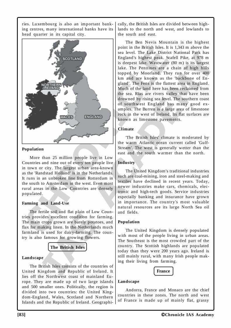
CHRO
NICLE
IAS ACADEM
Y
[83] Chronicle IAS Academy
ries. Luxembourg is also an important bank-ing centres, many international banks have itshead quarter in its capital city.
Population
More than 25 million people live in LowCountries and nine out of every ten people livein town or city. The largest urban area-knownas the 'Randstad Holland' is in the Netherlands.It runs in an unbroken line from Rotterdam inthe south to Amsterdam in the west. Even mostrural areas in the Low Countries are denselypopulated.
Farming and Land-Use
The fertile soil and flat plain of Low Coun-tries provides excellent condition for farming.The main crops grown are barely potatoes, andflax for making linen. In the Netherlands muchfarmland is used for dairy-farming. The coun-try is also famous for growing flowers.
The British Isles
Landscape
The British Isles consists of the countries ofUnited Kingdom and Republic of Ireland. Itlies off the Northwest coast of mainland Eu-rope. They are made up of two large islandsand 500 smaller ones. Politically, the region isdivided into two countries: the United King-dom-England, Wales, Scotland and NorthernIslands and the Republic of Ireland. Geographi-
cally, the British Isles are divided between high-lands to the north and west, and lowlands tothe south and east.
The Ben Nevis Mountain is the highestpoint in the British Isles. It is 1,343 m above thesea level. The Lake District National Park hasEngland's highest peak. Scafell Pike, at 978 mis deepest lake. Wastwater (80 m) is its largestlake. The Pennines are a chain of high hillstopped by Moorland. They run for over 400km and are known as the 'backbone of En-gland'. The Fens is the flattest area in England.Much of the land here has been reclaimed fromthe sea. Rias are rivers valley that have beendrowned by rising sea level. The southern coastof southwest England has many good ex-amples. The Burren is a large area of limestonerock in the west of Ireland. Its flat surfaces areknown as limestone pavements.
Climate
'The British Isles' climate is moderated bythe warm Atlantic ocean current called 'Gulf-Stream'. The west is generally wetter than theeast and the south warmer than the north.
Industry
The United Kingdom's traditional industriessuch are coal-mining, iron and steel-making andtextiles have declined in recent years. Today,newer industries make cars, chemicals, elec-tronic and high-tech goods. Service industriesespecially banking and insurance have grownin importance. The country's most valuablenatural resources are its large North Sea oiland fields.
Population
The United Kingdom is densely populatedwith most of the people living in urban areas.The Southeast is the most crowded part of thecountry. The Scottish highlands are populatedtoday than they were 200 years ago. Ireland isstill mainly rural, with many Irish people mak-ing their living from farming.
France
Landscape
Andorra, France and Monaco are the chiefcountries in these zones. The north and westof France is made up of mainly flat, grassy
CHRO
NICLE
IAS ACADEM
Y
[84] Chronicle IAS Academy
plains and low hills. Wooded mountain linethe country border in the south and east andmuch of central France is taken up by MassifCentral, an enormous plateau, cut by deep riv-ers valley and scattered with extinct volcanoes.Three major rivers. The Loire, Seine andGaronne drain the low land basins. The ParisBasin is a saucer-shaped hollow made up oflayers at hard and soft rock covered with veryfertile soil. It runs across about 100,000 sq.km. of Northern France. The Western end ofthe European Alpine Mountain chain stretchesinto southeast France. The French Alps can becrossed by several passes, which give access toItaly and Switzerland.
The coast of Normandy is lined with highchalk cliff. The Mount Blanc in the French Alpsis the tallest in Eastern Europe. It is 4,807 m.high. Pyrenees Mountain forms a natural bar-rier between France and Spain. Several of theirpeaks reach heights of over 3,000 meter. ThePyrenees are difficult to cross, due to theirheight and because they have few low passes.The vast granite plateau of Massif Central wasformed over 200 million years ago. Volcanicactivity here only stopped within the last 10,000years and regions rounded hills are the worndown remains of the volcanic mountain. TheCamargue is an area of marshes, pastures, sanddunes and salt flats at the mouth of the riverRhone. Rare animal and plant are found there.
Climate
In winter, the coldest areas of France aremountain of the Massif Central and the Alps.Summer is the hottest on Mediterranean coast.
Industry
France is one of world's top manufactur-ing nations, with a variety of both traditionaland high tech industries. Cars, machinery andelectronic products are exported worldwide,along the luxury goods such as perfumes, fash-ion and fine wines. Fossil fuel provides someenergy, but France is currently the world's sec-ond biggest producer of Nuclear power.
Population
In the past 50 years, most people have movedfrom the countryside into the urban areas. Parisand its suburb, the industrial cities, and the Coted'Azur in the southeast are parts of France andnow have the biggest population.
Farming and Land-Use
France is able to produce a variety of cropsbecause of its rich soil and mild climate. Wheatis grown in many parts of north, along withpotatoes and other vegetables. Fields of maizeand sunflower and fruit orchards are found inthe south, while grapes for the famous wineindustry grown across the country. Beef anddairy cattle are grazed on low-lying pasture.
Spain And Portugal
Landscape
Spain and Portugal occupy the IberianPeninsula which is cut off from the rest of theEurope by the Pyrenees. Over the centuries,Iberia has been invaded and settled by manydifferent peoples. The most of the inland inSpain is taken up by Meseta, a dry almost tree-less plateau surrounded by steep mountainranges. The only lowlands apart from narrowstripes along the Mediterranean coast are thevalleys of the Ebro, Tagus, Guadiana andGuadalquivir rivers. Portugal coast is lined bywide plains. Inland, the river Tagus divides thecountry in two. To the north, the land is hillyand wooded; to the south it is low-lying anddrier. The river Ebro carries vital irrigationwater to Spain's northeastern plains before flow-ing into the Mediterranean Sea. The westwardflowing rivers- Duero, Tagus, andGuadalquivir- flow across the Meseta on theircourses to the Atlantic Ocean. The Southernend of Mesta is marked by Sierra Morenamountain range. Mulhacen is the snow cappedSierra Nevada range in southern Spain is 3,481m high. It is Iberia's tallest mountain.
Climate
The Northern Spain is wetter and coolerthan the South. On the central plateau, sum-mers are very hot and dry, and winter often-freezing. The North of Portugal is cooled bywinds blowing off Atlantic Ocean. The southis warmer with dry mild winter.
Industry
Madrid Barcelona and the northern partsare Spain's chief industrial centres. Here, Ironore from Spanish mines is used to make steel,and factories produce cars, machinery andchemicals. Portugal exports textiles clothing andfootwear, along with fish such as sardines and
CHRO
NICLE
IAS ACADEM
Y
[85] Chronicle IAS Academy
tuna caught off the Atlantic coast. In bothcountries tourism is very important to theeconomy.
Population
In the first half of the 20th century mostSpaniards lived in villages or small towns, scat-tered around the countries. Today tourism andindustry have drawn most of the population tothe cities and coastal areas. Most Portuguesestill live in rural areas along the coast or in theriver valley, but the cities are growing fast.
Farming and Land Use
Cereals especially wheat and Barley areIberia's chief crops. In the dry south of Spain,the land is irrigated to grow citrus fruits espe-cially orange and vegetable. In both countriesolive trees and vineyard occupy large area ofland. Olive oil and wine are important export.Cork oak trees from Iberia forest supply 80 percent of the world cork.
Germany And Alpine States
Landscape
It consists of Austria, Germany,Liechtenstein, Slovenia and Switzerland. Ger-many is the biggest power in the continent. Tothe north, flat plains and heathlands surroundthe North Sea coast. Further south areGermany's central uplands which are lowerand older than the jagged peaks of the Alps,which began to form about 65 million yearsago. From its source in the Black forest, theRiver Danube flows eastward across Germanyand Austria on its course to the Black Sea. Theother major river, the Rhine, flows northward.The Rhine is Germany's main waterway. It isan important transport route to and fromNorthern ports. It twists and turns across 1,320km of Europe from its source in southeastSwitzerland to the North Sea. The Danube isEurope's second longest river flowing 2,840 km.Lake Constance covers 54 sq km and isGermany's largest lake, although its water areshared by Austria and Switzerland. The Alpswere formed when African plate collided withthe Eurasian plate, pushing up and crushinghuge amount of rock, to form mountain. TheHarz Mountains are much older than the Alps.They were formed over 300 million years ago.Most of the water of the limestone Karst regionof Slovenia flows underground through hugecaves and caverns.
Climate
Winter temperature decreases eastwardsand the high alpine region is coldest. Climatevariations in the Alps are common due to tur-bulent airflows.
Industry
Germany is a leading manufacturer of cars,chemicals, machinery and transport equipment.Switzerland and Liechtenstein with few rawmaterials make high value products such aswatches and pharmaceuticals and provide ser-vices such as banking. The Alpine states arepopular tourist locations all year round.
Population
Western and central Germany are the mostdensely populated areas in the region- particu-larly in and around the Rhine and Ruhr val-leys, where there are many industries. In thesouth, the steep slopes of the Alps and perma-nent snow cover on the higher peaks meansthat most large towns and cities are in scat-tered lowland area.
Farming and Land Use
Germany produces three quarters of itsown food. Crop farming is widespread, withcereals and root grown in flat fertile areas.Cattle and Pig rearing supply meat and dairyproducts. Across the Alps, the mountains limitfarming, although vines are grown on thewarmer south facing slopes. The rich pasturesof the lower slopes are used to graze beef anddairy cattle.
Italy
Landscape
Italy is a type of peninsula jutting southfrom mainland Europe into Mediterranean Sea.In Northern and Central Italy the land is mainlymountainous. Most of the flat land is in PoValley and along the eastern coast. Italy lieswithin an earthquake zone which makes theland unstable and there are also a number ofactive volcanoes. The basins of the river Po hasthe best soils in Italy. Rich alluvium is washedfrom the mountains by the rivers to form awide plain. The great lakes like Garda andComo fill several south-facing valleys once oc-cupied by glaciers. The Dolomites are high
CHRO
NICLE
IAS ACADEM
Y
[86] Chronicle IAS Academy
mountains are parts of same range as the Alps.They were formed 65 million years ago. TheApennines mountain, range formed the back-bone of the Italy dividing the rock west coastfrom the flatter sandy east coast.
Sardinia Island is made from very old rockswhich were up-thrusted to form mountains.The Tyrrhenian Sea divides the Italian main-land from Sardinia is gradually filling withsediments from the rivers, which flows into it.Sicily is the largest islands in Mediterranean. Ithas a famous active volcano called 'Mount Etna'and often experiences earth quakes.
Climate
The Alpine North has cold winters oftenwith snow. Further south temperature arehigher. Sicily has Italy's highest temperaturedue to warm African wind.
Industry
Italian Industry is located mainly in thenorth. Design is extremely important to Ital-ians and they are proud of the elegant designof their furniture, clothes and shoe. Thoughmany firms are small, they are very efficient.Italy has few minerals resources so it needs toimport new materials to make cars, engine andother high-tech products.
Population
Most of the Italy's population lives in theNorth, mainly in and around the Po Valley,which is home to over 25 million people. Mostpeople here have high standard of living. South-ern Italy is much more rural towns are smallerand life is often much harder.
Central Europe
Landscape
It consists of Czech Republic, Hungry,Poland and Slovakia. The high CarpathianMountains sweep across the northern Slovakia.The lower Sudeten Mountain lies on the bor-der of the Czech Republic and Poland. Togetherthese mountains form a barrier which dividesthe Great Hungarian plain and the Dannbe riverbasin in the South from Poland and the vastrolling lowlands of the North European plain.Pomeriania is a sandy coastal area with lakesformed by glaciers. It stretches west from the
River Vistula to just beyond the German bor-der; Poland's largest river is the river Vistula. Itflows northwards passing through the capital,Warsaw on the way to the Baltic Sea. TheSudeten Mountains are famous for their hotminerals springs. These occur where waterheated deep within the Earth's crust finds itsway to the surface along fracture in the rock.The River Danube forms the border betweenSlovakia and Hungary for over 162 km. It thenturns south to flow across the Great Hungar-ian plains. The Great Hungarian Plains coversalmost half of Hungary's land area. It is amixture of farmland and Steppe. The TatraMountains are a small range at northern endof the Carpathian Mountains. They includeGeriachousky which is central Europe's high-est point at 2,655 m.
Climate
The Carpathian Mountains are both thecoldest and the wettest part of Central Europe.Temperature plunges below zero across thewhole region during winter. In summer, east-ern Hungary is the hottest place.
Industry
Brown coal or lignite is central Europe'smain fuel and one of Poland's major exports.A variety of minerals are mined in the moun-tains of Czech Republic and Slovakia. Hun-gary has a wide range of industries producingvehicles, metals and chemicals as well as tex-tile and electrical goods. The Czech Republic isfamous for its breweries and glass making.
Farming and Land Use
Central Europe's main crops are cerealssuch as maize, wheat and rye, along with sugarbeet and potatoes. In Hungary, sweet peppergrows, helped by the warm summers and mildwinters. They are used to make paprika. Grapesare also grown, to make wine. Large areas ofthe plains of Hungary and Poland are used forrearing pigs and cattle. Trees for timber growin the mountain of Slovakia and Czech Repub-lic.
Population
Most people in central Europe live in lowlaying areas, for example, along the RiverVistula in Poland and in the lowlands of theCzech Republic. In mountainous Slovakia many
CHRO
NICLE
IAS ACADEM
Y
[87] Chronicle IAS Academy
people still live in rural towns and villages. Theindustrial areas and capital cities have the high-est population densities.
South East Europe
Landscape
It consists of Albania, Bosnia andHerzegovina, Bulgaria, Croatia, Greece,Macedonia, Yugoslavia (Serbia andMontenegro). The Southeast Europe is largelymountainous with range running from north-west to southeast. The Dinaric Alps runs par-allel to the Dalmatian coast, and the PindusMountain continue this line into Greece. In theAegean Sea the drowned peaks of an oldmountain chain form thousands of islands. TheVojvodina region of Yugoslavia is the southernpart of the great Hungarian plains. The plainis flat and fertile soil allows grain crops likecorn and wheat to be grown.
The Balkan Mountains forms a spur run-ning east to west through Bulgaria and sepa-rate the two main rivers the Danube and theMaritsa. Dalmatian coast has many long, nar-row islands near the shore. These were formedas the Atlantic Sea flooded the river valleywhich ran parallel to the coast. The Peloponneseis a mountainous peninsula linked to the Greekmainland only by a narrow strip of land calledan isthmus. There are two groups of Greekislands-the Ionian island of the west of main-land Greece, and the more numerous islandsto the east in Aegean Sea.
Climate
The Southern Europe's climate varies fromnorth to south. Continental climates are foundin the north; winters are cold and dry whiletowards the south, winters are milder andsummers much hotter. Europe's wettest placeis found in the mountain in Bosnia andHerzegovina.
Industry
The mainland Greece and the many islandsin the Aegean Sea are centre of a thriving tour-ist trade, while tourism on the Black Sea coastcontinues to grow. The Dalmatian coast had asmall, but growing tourist industry until thecivil war in former Yugoslavia disrupted thatand other industries. Heavy industries likechemicals, engineering and ship-building re-
main an important source of income in Bul-garia.
Population
Greece population is mostly urban; over 50per cent live in the capital Athens and inSalonica. In Bulgaria, most people live in cities.About half of Albania's and Macedonia's peopleare still rural. Since the civil war, the differentethnic groups in Bosnia and Herzegovina, Yu-goslavia and Croatia have lived from one an-other.
Eastern Europe
Landscape
It consists of Belorussia, Moldavia, Roma-nia and Ukraine. The flat and rolling grass-land, marshes and rivers, flood plains coversalmost all of Ukraine and Belorussia. TheCarpathian Mountains cross the southwesterncorner of Ukraine and continue a large arcshaped chain of high peaks at the heart ofRomania. Along the southern part of this chainthe Carpathians are called the TransylvanianAlps. The Pripet Marshes in Belorussia andUkraine form the longest area of marshland inEurope. The Steppes are great wide grassland,which are found across Eastern Europe andcentral Asia. Over 70% of the Ukrainian land-scape is Steppe. The Crimea Peninsula dividesthe Sea of Azov from the Black Sea. The steepmountain of Krymsk Hory runs along the south-eastern coast of Crimea.
Climate
The climate is continental with warm drysummers and very cold dry winters. Tempera-tures are higher along the fringe of the BlackSea while the Carpathian Mountains are colderand wetter all year round.
Industry
In Ukraine, most industry is based on thecountry's minerals reserve. The Donbas regionhas Europe's largest coalfield and is an impor-tant centre for iron and steel production.Belorussia's main industries are chemicals; ma-chine building and food processing. Romania'smanufacturing industries are growing with thehelp of foreign investment.
Farming and Land Use
CHRO
NICLE
IAS ACADEM
Y
[88] Chronicle IAS Academy
The Black soils found across much ofUkraine are very fertile and the country is abig producer of cereals sugar beet and sun-flowers, which are grown for their oil. InMoldavia and southern Romania the warmsummers are ideal for growing grapes for wine,along with sunflowers and variety of vegetables.Cattle and Pigs are farmed throughout EasternEurope.
Population
Most Romanians live in Bucharest, the capi-tal or in other cities and towns. In Ukraine,two third of the population lived in the citiesin the Donbas industrial area. Most of theBelorussian people are city dwellers. Moldovais the most rural country in Eastern Europe;half its people live in the countryside and maketheir living from farming.
The Mediterranean
Landscape
The Mediterranean Sea separates Europefrom Africa. It stretches more than 4,000 kmfrom east to west. The Mediterranean Seawould be an enormous lake if it were not forstrait of Gibraltar, a narrow opening only 13km wide which joins it to the Atlantic Ocean.The Mediterranean lies over the boundary oftwo continental plates. The Mediterraneancoasts are bordered by several thousand milesof sandy beaches. The area of sea off the coastof Tunisia and also the Adriatic Sea are shal-lower than the rest of the Mediterranean. Therugged Atlas Mountain runs through the mostof Morocco and Algeria. They form a barrierbetween the Mediterranean and the Sahara,which lies south to them. Greek Islands hasthousands of islands, which lie, both in theMediterranean and in the smaller Aegean Sea.Some of them are the remains of old volcanoeswhich has left black sand on the beaches. SuezCanal links the Mediterranean to the Gulf ofSuez and the Red Sea. Before it was built shiphad to sail around the whole of Africa to reachAsia.
Tourism
The tourism industry in and around theMediterranean is one of the most highly devel-oped in the world. More than half of the world'sincome from tourism is generated here. Resorts
have grown up along the northwest coast ofAfrica, and in Egypt, in southern Spain, France,Italy, Greece and Turkey, tourism brings hugeeconomic benefit.
Industry
The Mediterranean has a large fishing in-dustry, although most of the fishing is small-scale. Tuna and Sardines are caught through-out the region and mussels are found off thecoast of Italy. Fish canning and packing takesplace at most of the larger ports. Small oil andgas reserves are extracted off the coast of NorthAfrica and near Greece, Spain and Italy.
Points to Remember
1. Europe is the sixth largest continent withan area of 10,360,000 sq km.
2. The highest point in Europe is Mont Blanc(4807 m) in the Alps and Mt Elbrus (5633m) in the Caucasus.
3. Belgium and Netherlands are the two smalllow lands countries very thickly populated.
4. Iceland, Norway, Sweden and Denmark arecollectively known as Scandinavia.
5. The Seine and Rhine are the importantrivers that join the English Channel andthe North Sea.
6. The Volga, which is the largest river ofEurope, joins a landlocked Sea named theCaspian.
7. Elbrus is the highest mountain peak inEurope, which lies in the Caucasus.
8. Lombardy in Italy and the lowlands ofAndalusia in Spain and the plains ofHungry are the lowlands.
9. More than 700 million people live in Europeand its population is highly urbanized.
10. Rotterdam, in the Netherlands is a part ofconurbation, a large built up are withseveral towns and cities.
11. Temperate type of climate is found inEurope.
12. North European plain is the Europe'sagricultural heart.
13. The Alps were formed when after can platecollided with the Eurasian Plate..
14. Estonia, Latvia and Lithuania are together
CHRO
NICLE
IAS ACADEM
Y
[89] Chronicle IAS Academy
called 'Baltic State.'
15. Belgium, Luxemberg and Netherlands arecalled 'Low countries.'
16. The plain of Flanders in Western Germanyhas fertile soil.
17. The Burren is a large area of limestone rockin the west of Ireland. Its flat surfaces areknown as limestones pavements.
18. The coast of Normandy is lined with highchalk cliffs.
19. The Duero, Tagus and Guadalquivir riversflow across the Meseta on their courses toAtlantic Ocean.
20. Germany is a leading manufacturer of cars,machinery and transport equipment.
21. Sicily is the largest islands inMediterranean. It has a famous activevolcano called Mount Etna.
22. The Po Valley is a broad flat plain in Northof Italy.
23. Sicily has Italy's highest temperature, dueto warm African winds.
24. The Poland's largest river is Vistula. It flowsnorthwards, passing through the capitalWarsaw on its way to the Baltic Sea.
25. TheTatra Mountains are small range at thenorthern end of the Carpathian Mountains.
26. The Balkan Mountains forms a spur runningeast to west through Bulgaria and separate
the two main rivers, the Danube and theMaritsa.
27. Carpathian Mountain Range is the largestmountain range in Eastern Europe. Theyare rich source of timber and minerals.
28. Suez Canal links the Mediterranean to theGulf of Suez and the Red Sea. Before itwas built, ship had to sail around the wholeof Africa to reach Asia.
29. The Atlas Mountains runs through most ofMorocco and Algeria. They form barrierbetween the Mediterranean coast and theSahara, which lies south of them.
30. The Carpathian Mountains are both thecoldest and the wettest parts of centralEurope.
31. Tyrrhenian Sea divides the Italian mainlandfrom Sardinia is gradually filling withsediments from the rivers, which flow intoit.
32. Poland's largest river is the Vistula. It flowsnorthwards passing through the CapitalWarsaw.
33. Central Europe's main crops are cerealssuch as maize, wheat and rye, along withsugar beet and potatoes.
34. The worst nuclear incident in historyhappened at Chernobyl's nuclear powerstation in Northern Ukraine.
•••
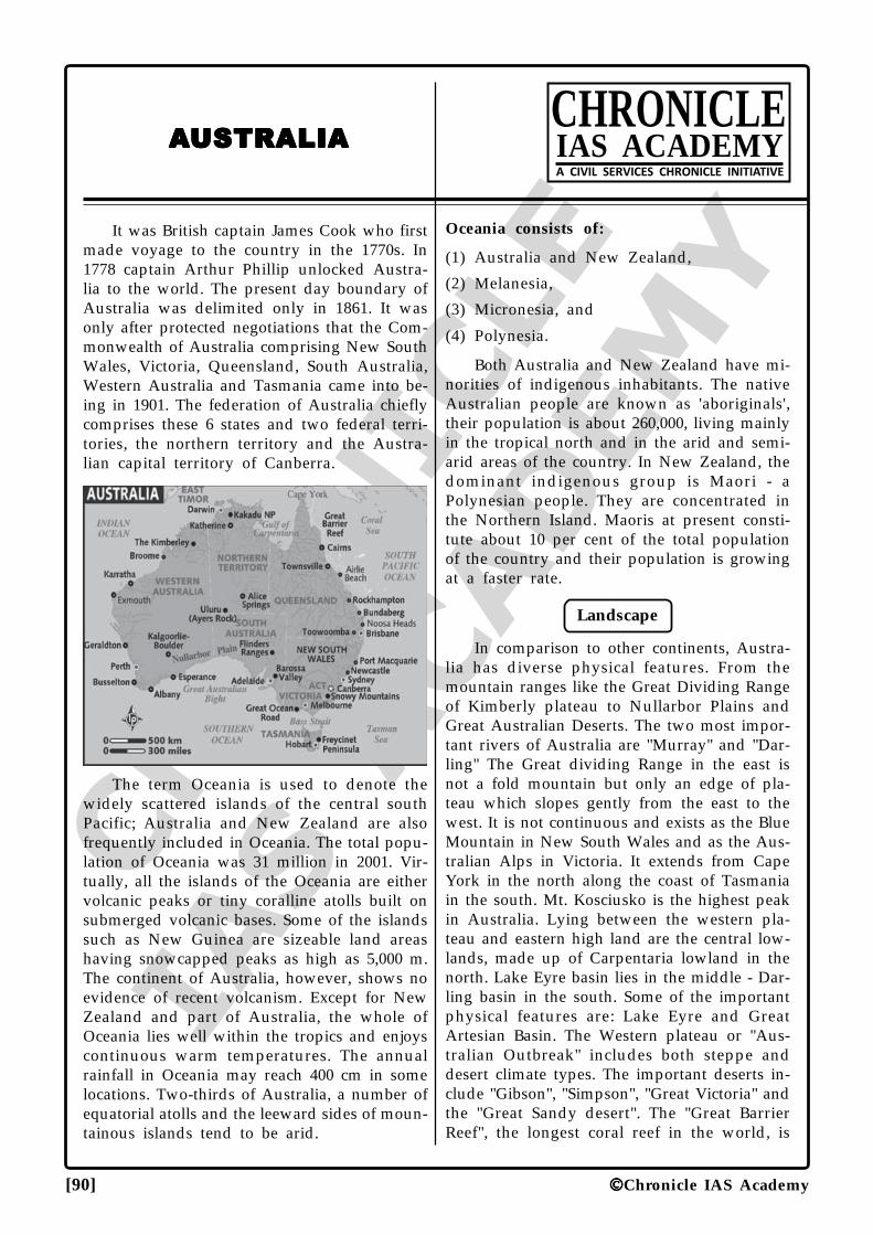
CHRO
NICLE
IAS ACADEM
Y
[90] Chronicle IAS Academy
AAAAAUSTRALIAUSTRALIAUSTRALIAUSTRALIAUSTRALIACHRONICLEIAS ACADEMYA CIVIL SERVICES CHRONICLE INITIATIVE
It was British captain James Cook who firstmade voyage to the country in the 1770s. In1778 captain Arthur Phillip unlocked Austra-lia to the world. The present day boundary ofAustralia was delimited only in 1861. It wasonly after protected negotiations that the Com-monwealth of Australia comprising New SouthWales, Victoria, Queensland, South Australia,Western Australia and Tasmania came into be-ing in 1901. The federation of Australia chieflycomprises these 6 states and two federal terri-tories, the northern territory and the Austra-lian capital territory of Canberra.
The term Oceania is used to denote thewidely scattered islands of the central southPacific; Australia and New Zealand are alsofrequently included in Oceania. The total popu-lation of Oceania was 31 million in 2001. Vir-tually, all the islands of the Oceania are eithervolcanic peaks or tiny coralline atolls built onsubmerged volcanic bases. Some of the islandssuch as New Guinea are sizeable land areashaving snowcapped peaks as high as 5,000 m.The continent of Australia, however, shows noevidence of recent volcanism. Except for NewZealand and part of Australia, the whole ofOceania lies well within the tropics and enjoyscontinuous warm temperatures. The annualrainfall in Oceania may reach 400 cm in somelocations. Two-thirds of Australia, a number ofequatorial atolls and the leeward sides of moun-tainous islands tend to be arid.
Oceania consists of:
(1) Australia and New Zealand,
(2) Melanesia,
(3) Micronesia, and
(4) Polynesia.
Both Australia and New Zealand have mi-norities of indigenous inhabitants. The nativeAustralian people are known as 'aboriginals',their population is about 260,000, living mainlyin the tropical north and in the arid and semi-arid areas of the country. In New Zealand, thedominant indigenous group is Maori - aPolynesian people. They are concentrated inthe Northern Island. Maoris at present consti-tute about 10 per cent of the total populationof the country and their population is growingat a faster rate.
Landscape
In comparison to other continents, Austra-lia has diverse physical features. From themountain ranges like the Great Dividing Rangeof Kimberly plateau to Nullarbor Plains andGreat Australian Deserts. The two most impor-tant rivers of Australia are "Murray" and "Dar-ling" The Great dividing Range in the east isnot a fold mountain but only an edge of pla-teau which slopes gently from the east to thewest. It is not continuous and exists as the BlueMountain in New South Wales and as the Aus-tralian Alps in Victoria. It extends from CapeYork in the north along the coast of Tasmaniain the south. Mt. Kosciusko is the highest peakin Australia. Lying between the western pla-teau and eastern high land are the central low-lands, made up of Carpentaria lowland in thenorth. Lake Eyre basin lies in the middle - Dar-ling basin in the south. Some of the importantphysical features are: Lake Eyre and GreatArtesian Basin. The Western plateau or "Aus-tralian Outbreak" includes both steppe anddesert climate types. The important deserts in-clude "Gibson", "Simpson", "Great Victoria" andthe "Great Sandy desert". The "Great BarrierReef", the longest coral reef in the world, is
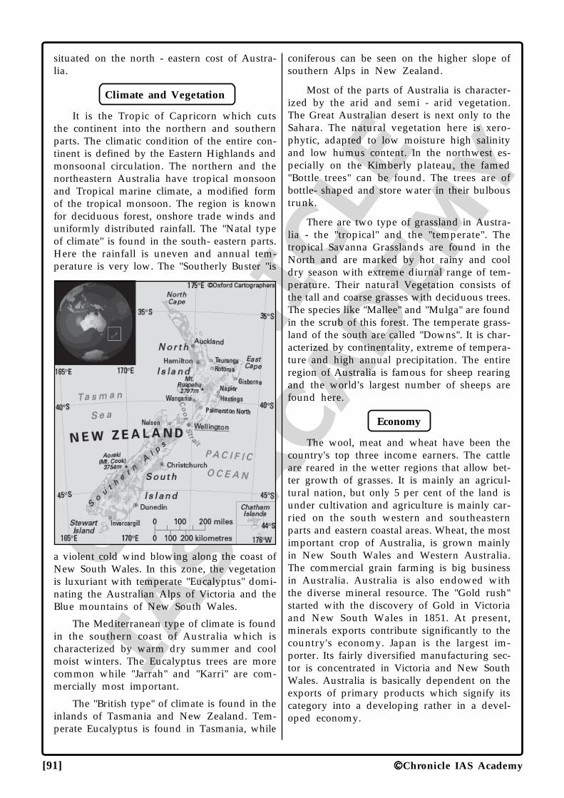
CHRO
NICLE
IAS ACADEM
Y
[91] Chronicle IAS Academy
situated on the north - eastern cost of Austra-lia.
Climate and Vegetation
It is the Tropic of Capricorn which cutsthe continent into the northern and southernparts. The climatic condition of the entire con-tinent is defined by the Eastern Highlands andmonsoonal circulation. The northern and thenortheastern Australia have tropical monsoonand Tropical marine climate, a modified formof the tropical monsoon. The region is knownfor deciduous forest, onshore trade winds anduniformly distributed rainfall. The "Natal typeof climate" is found in the south- eastern parts.Here the rainfall is uneven and annual tem-perature is very low. The "Southerly Buster "is
a violent cold wind blowing along the coast ofNew South Wales. In this zone, the vegetationis luxuriant with temperate "Eucalyptus" domi-nating the Australian Alps of Victoria and theBlue mountains of New South Wales.
The Mediterranean type of climate is foundin the southern coast of Australia which ischaracterized by warm dry summer and coolmoist winters. The Eucalyptus trees are morecommon while "Jarrah" and "Karri" are com-mercially most important.
The "British type" of climate is found in theinlands of Tasmania and New Zealand. Tem-perate Eucalyptus is found in Tasmania, while
coniferous can be seen on the higher slope ofsouthern Alps in New Zealand.
Most of the parts of Australia is character-ized by the arid and semi - arid vegetation.The Great Australian desert is next only to theSahara. The natural vegetation here is xero-phytic, adapted to low moisture high salinityand low humus content. In the northwest es-pecially on the Kimberly plateau, the famed"Bottle trees" can be found. The trees are ofbottle- shaped and store water in their bulboustrunk.
There are two type of grassland in Austra-lia - the "tropical" and the "temperate". Thetropical Savanna Grasslands are found in theNorth and are marked by hot rainy and cooldry season with extreme diurnal range of tem-perature. Their natural Vegetation consists ofthe tall and coarse grasses with deciduous trees.The species like "Mallee" and "Mulga" are foundin the scrub of this forest. The temperate grass-land of the south are called "Downs". It is char-acterized by continentality, extreme of tempera-ture and high annual precipitation. The entireregion of Australia is famous for sheep rearingand the world's largest number of sheeps arefound here.
Economy
The wool, meat and wheat have been thecountry's top three income earners. The cattleare reared in the wetter regions that allow bet-ter growth of grasses. It is mainly an agricul-tural nation, but only 5 per cent of the land isunder cultivation and agriculture is mainly car-ried on the south western and southeasternparts and eastern coastal areas. Wheat, the mostimportant crop of Australia, is grown mainlyin New South Wales and Western Australia.The commercial grain farming is big businessin Australia. Australia is also endowed withthe diverse mineral resource. The "Gold rush"started with the discovery of Gold in Victoriaand New South Wales in 1851. At present,minerals exports contribute significantly to thecountry's economy. Japan is the largest im-porter. Its fairly diversified manufacturing sec-tor is concentrated in Victoria and New SouthWales. Australia is basically dependent on theexports of primary products which signify itscategory into a developing rather in a devel-oped economy.
CHRO
NICLE
IAS ACADEM
Y
[92] Chronicle IAS Academy
About New Zealand
The small island "New Zealand" lies acrossthe Tasman Sea. It is the "Maoris" who firstinhabited here. Abel Tasman landed on theisland in 1640 from when the process of colo-nization started. New Zealand mainly consistsof two main islands - the North and the Southand a number of smaller ones. The south is-land is relatively longer than the North islands,but they together constitute bigger in size thatthe Great Britain. "Mt. Cook" is the highest peakin New Zealand which lies in the SouthernAlps. The "Taranaki plain" is the slope of thecentral highlands in North islands and an im-portant pasture land. The "Canterbury Plains"of the south island are also important for cattle.The Europeans account for 85 per cent of thetotal population while the "Maoris" constituteonly 10 percent. New Zealand is also one ofthe foremost milk producing countries. The coldand humid climate is very conducive for thegrowth of nutritious grasses. The Canterburyplain of New Zealand is well known for sheeprearing and is the main farming regions of"New Zealand."
Continental Facts
• "Sydney": It is the oldest and largest cityof Australia. Its harbour, "Port Jackson",is the biggest port of Australia and themain export centre of wheat and wool.It was the venue of the millennium's lastOlympics. The "Sydney Opera House"and "Sydney Harbours" are well knownacross the world.
• "Boomtang": It is a carved throwing clubof tough wood used by the Australiansaborigine. It is widely used for hunting.
• "Canberra": It is the capital of Australiaand located on the "Molonglo River".Canberra was built as a compromisecapital in order to stop squabbling be-tween Melbourne and Sydney.
• Great Barrier Reef: It is the world's long-est coral reef which extends like a long- ridge off the north - east coast ofQueensland. It consists of thousands ofseparate reef. The reef is generally formedfrom the calcareous remains of micro -organism which is known as "coral pol-yps", at present the reef is facing threatfrom environmental degradation espe-cially from tourists.
• The Northern Territory: It is the onlyfederal territory that has legalised vol-untary "euthanasia". It was done in"1995".
• "BSC-MA-PhD": This acronym refers tothe mnemonics for clockwise arrange-ment of the Australian coastal citieswhich starts from Brisbane, Sydney,Canberra, Melbourne, Adelaide, Perthand Darwin.
• "Don Bradman": He was the legendrycricketer and regarded as an idol and anational treasure by the Australians. Hesymbolizes Australian nationalism likeno one else.
• "Koala": The Guinness Book records itas the most discriminating "mammalianeater". It feed exclusively on eucalyptusleaves.
• "Road Trains": It is a type of transpor-tation unique to Australian road inwhich several cargos - container likeboxes are connected end to end andhauled by a common engine. They areused by transport cattle and horses.
• "Artesian Basin": It is a type of struc-tural basin of sedimentary rocks whichproduces a constant supply of water thatrises to the ground surface by means ofan artesian well from a subterraneanaquifer which hold water under a pres-sure-head and is sandwiched betweentwo layers of impermeable strata. Aus-tralia and New Zealand have some ofthe largest Artesian basin of the worlds.
• "Niue": It is a self- governing overseasterritory of New Zealand which wassighted by captain James Cook in 1774who called it the Savage Island. It is theworld's largest uplifted coral islands andthe New Zealand has responsibility oflooking after external affairs and defenceof this Island.
• "Ayers Rock": It is a conspicuousInselberg which reaches out to a heightof 348 m as a huge red rock in themiddle of a desert.
• "Australian-Trans-Continental Rail-ways": It is an important link which con-nects "Sydney with Perth". Important sta-tions on this route are mining towns likeBroken Hills, Peterborough, Port Augusta,Karlgoorlie, Coolgardie etc.
CHRO
NICLE
IAS ACADEM
Y
[93] Chronicle IAS Academy
Points to Remember
1. The Australian cities in decreasing order ofpopulation are Sydney, Melbourne andBrisbane.
2. Australian states in decreasing order ofpopulation are; New South Wales - Victoria- Queensland - Western Australia.
3. Australia is one of the most importantmembers of "common wealth".
4. Australia is world's largest producer of"bauxite".
5. Western Australia is the largest state whileNew South Wales is the most populous.
6. New Zealand coast was explored by Cookin 1769.
7. The major roads in Australia are called"Commonwealth Highway".
8. The "Trans- Continental Stuart Highway"connects Birdum (Northern Territory) toOodnadatta (South - Australia) via AliceSpring and Tennant Greek.
9. "Rotorua and Maoti' towns have hot gey-sers; "Pohutu Geyser " is the most famousone.
10. Australia is the "smallest" of all continents.
11. Australia stands for Australia and NewZealand.
12. The largest state of Australia is the "WesternAustralia".
13. The largest city of Australia is Sidney.
14. "Emu" is the flightless bird of Australia.
15. The New Zealander who was first to scaleMt. Everest was "Edmund Hillary".
16. "Niue" is the highest uplifted coral island ofthe world.
17. "Canterbury plains" is the chief farmingregion of the New Zealand.
18. "Mt Cook" is the highest peak of NewZealand.
19. "Taranaki plain" of New Zealand is famousfor the dairy industry.
20. "Lake Eyre" is the region of inland drainagein Australia.
21. "The Great Artesian Wells" is the naturalfountain in Australia.
22. "Mt. Kosciusko" is the highest mountainpeak in Australia.
23. "Auckland" is the most populous urbancentre in New Zealand.
24. "Abel Tasman" was the first European todiscover New Zealand.
25. "Bass strait" is the strait between Australiaand Tasmania.
26. The "Great Barrier Reef" lies on the coast of"Queensland".
27. The "Cook Strait" is the strait between theNorth and South island of New Zealand.
28. The pride of Australia Don Bradman hailsfrom the city of "Brisbane".
29. "Marambidgee" is the longest tributary of"Murray - Darling".
30. "Kalgoorlie" is famous for "Gold - Mining".
31. "Platypus" is an animal bird with 4 legs thatlays eggs.
32. "Kangaroo" is the national animal of Aus-tralia.
33. "Wellington" is the southernmost capitalcity of the world.
34. "Qantas Airways" is the international air-line of Australia.
35. "Maoris" is the aborigines of New Zealandof Polynesian descent.
36. "Gippsland" is famous for petroleum.
37. "Sheep - rearing farm" in Australia is calledstations.
38. "Hobart" is the capital of Tasmania.
39. "Victoria" is the most industrialized state ofAustralia.
40. "Mt. Tom Price" is famous for Iron.
41. Lead, Zinc and Silver are mined at Mt. Isaand Broken Hills.
42. "Downs" is the temperate grassland ofAustralia.
43. "Torres Strait" lies between Australia andNew Guinea.
44. "Trans - Australian Railways" runs betweenPerth and Sydney.
45. "Freemantle" is the out port of Perth.
46. "Bindibu" are the aborigines of Australia.
47. Canberra is located on the banks of river"Molonglo".
48. New South Wales is the most populated ofthe Australian states.
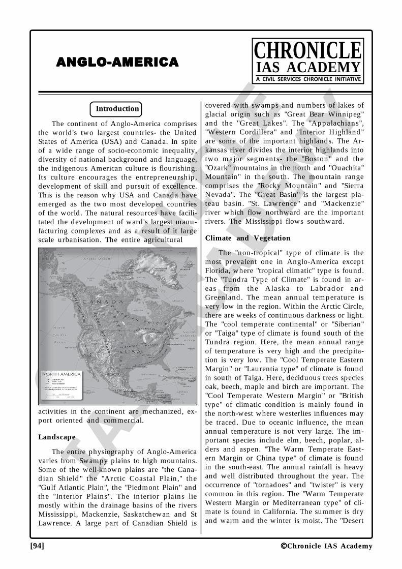
CHRO
NICLE
IAS ACADEM
Y
[94] Chronicle IAS Academy
ANGLO-AMERICAANGLO-AMERICAANGLO-AMERICAANGLO-AMERICAANGLO-AMERICACHRONICLEIAS ACADEMYA CIVIL SERVICES CHRONICLE INITIATIVE
Introduction
The continent of Anglo-America comprisesthe world's two largest countries- the UnitedStates of America (USA) and Canada. In spiteof a wide range of socio-economic inequality,diversity of national background and language,the indigenous American culture is flourishing.Its culture encourages the entrepreneurship,development of skill and pursuit of excellence.This is the reason why USA and Canada haveemerged as the two most developed countriesof the world. The natural resources have facili-tated the development of ward's largest manu-facturing complexes and as a result of it largescale urbanisation. The entire agricultural
activities in the continent are mechanized, ex-port oriented and commercial.
Landscape
The entire physiography of Anglo-Americavaries from Swampy plains to high mountains.Some of the well-known plains are "the Cana-dian Shield" the "Arctic Coastal Plain," the"Gulf Atlantic Plain", the "Piedmont Plain" andthe "Interior Plains". The interior plains liemostly within the drainage basins of the riversMississippi, Mackenzie, Saskatchewan and StLawrence. A large part of Canadian Shield is
covered with swamps and numbers of lakes ofglacial origin such as "Great Bear Winnipeg"and the "Great Lakes". The "Appalachians","Western Cordillera" and "Interior Highland"are some of the important highlands. The Ar-kansas river divides the interior highlands intotwo major segments- the "Boston" and the"Ozark" mountains in the north and "Ouachita"Mountain" in the south. The mountain rangecomprises the "Rocky Mountain" and "SierraNevada". The "Great Basin" is the largest pla-teau basin. "St. Lawrence" and "Mackenzie"river which flow northward are the importantrivers. The Mississippi flows southward.
Climate and Vegetation
The "non-tropical" type of climate is themost prevalent one in Anglo-America exceptFlorida, where "tropical climatic" type is found.The "Tundra Type of Climate" is found in ar-eas from the Alaska to Labrador andGreenland. The mean annual temperature isvery low in the region. Within the Arctic Circle,there are weeks of continuous darkness or light.The "cool temperate continental" or "Siberian"or "Taiga" type of climate is found south of theTundra region. Here, the mean annual rangeof temperature is very high and the precipita-tion is very low. The "Cool Temperate EasternMargin" or "Laurentia type" of climate is foundin south of Taiga. Here, deciduous trees speciesoak, beech, maple and birch are important. The"Cool Temperate Western Margin" or "Britishtype" of climatic condition is mainly found inthe north-west where westerlies influences maybe traced. Due to oceanic influence, the meanannual temperature is not very large. The im-portant species include elm, beech, poplar, al-ders and aspen. "The Warm Temperate East-ern Margin or China type" of climate is foundin the south-east. The annual rainfall is heavyand well distributed throughout the year. Theoccurrence of "tornadoes" and "twister" is verycommon in this region. The "Warm TemperateWestern Margin or Mediterranean type" of cli-mate is found in California. The summer is dryand warm and the winter is moist. The "Desert
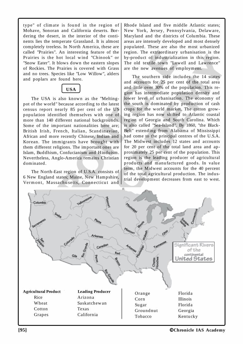
CHRO
NICLE
IAS ACADEM
Y
[95] Chronicle IAS Academy
type" of climate is found in the region ofMohave, Sonoran and California deserts. Bor-dering the desert, in the interior of the conti-nents lies the temperate Grassland. It is almostcompletely treeless. In North America, these arecalled "Prairies". An interesting feature of thePrairies is the hot local wind "Chinook" or"Snow Eater". It blows down the eastern slopesof Rockies. The Prairies is covered with Grassand no trees. Species like "Low Willow", aldersand poplars are found here.
USA
The USA is also known as the "Melting-pot of the world" because according to the latestcensus report nearly 85 per cent of the USpopulation identified themselves with one ofmore than 140 different national backgrounds.Some of the important nationalities here are;British Irish, French, Italian, Scandinavian,African and more recently Chinese, Indian andKorean. The immigrants have brought withthem different religions. The important ones areIslam, Buddhism, Confucianism and Hinduism.Nevertheless, Anglo-America remains Christiandominated.
The North-East region of U.S.A. consists of6 New England states; Maine, New Hampshire,Vermont, Massachusetts, Connecticut and
Rhode Island and five middle Atlantic states;New York, Jersey, Pennsylvania, Delaware,Maryland and the districts of Columbia. Theseareas are intensely developed and most denselypopulated. These are also the most urbanizedregion. The extraordinary urbanisation is theby-product of industrialization in this region.The old textile town "Lowell and Lawrence"are the new avenues of employment.
The southern side includes the 14 statesand accounts for 25 per cent of the total areaand little over 30% of the population. This re-gion has intermediate population density andlower level of urbanisation. The economy ofthe south is dominated by production of cashcrops for the world market. The cotton grow-ing region has now shifted to Atlantic coastalregion of Georgia and South Carolina. Whichis also called "Sea-Island". By 1860, "the Black-Belt" extending from Alabama of Mississippihad come to the principal centres of the U.S.A.The Midwest includes 12 states and accountsfor 20 per cent of the total land area and ap-proximately 25 per cent of the population. Thisregion is the leading producer of agriculturalproducts and manufactured goods. In valueterm, the Midwest accounts for the 40 percentof the total agricultural production. The indus-trial development decreases from east to west.
Agricultural Product Leading ProducerRice ArizonaWheat SaskatchewanCotton TexasGrapes California
Orange FloridaCorn IllinoisSugar FloridaGroundnut GeorgiaTobacco Kentucky
CHRO
NICLE
IAS ACADEM
Y
[96] Chronicle IAS Academy
Apple Nova ScotiaCorn OntarioBarley AlbertaOats Alberta
The Western region comprises 11 states andaccounts for 33 per cent of the land area and20 percent of the population. In spite of watershortage, the region accounts for 20 per cent ofthe agricultural production. In southern Cali-fornia, the favorable climate and irrigation fromthe mountain streams supports the productionof citrus fruits. Today the central valley ishighly productive. "Oregon and Washington"are the leading producer of timber especiallysoftwood varieties like "Douglas fir". The "Sili-con Valley" of San Francisco region is wellknown for computers and biotechnology. The"Boeing Company of aircraft manufacturing"is located in Seattle. The copper in "Arizona"and oil and coal in "Utah" is well known. Thewestern Pacific is now emerging as the world'smost economically dynamic region.
Canada
At present, Canada is one of the most in-dustrialized and technologically advanced andurbanized state of the world. The prominentcharacteristic of Canada is the greater relianceon the export of raw and semi-finished mate-rial while it imports the manufactured goods.The overbearing influence on U.S.A. on Canadahas been a sure point to many Canadians whothink of themselves as "American Colony".
Social Aspect
A large part of Canadian population is con-centrated around its border with the U.S. Infact 70 to 80 percent of the population liveswithin 160 km of the border. Canada's popu-lation cluster may be grouped into four mainregions:
(i) Atlantic region in the northeast
(ii) Culturally divided core region of maximumpopulation and development along the St.Lawrence River in Ontario and Quebec
(iii)the Prairies region of interior plains and
(iv)Vancouver region in the south-west.City RiversNew York HudsonChicago ChicagoPhiladelphia Lower DelawareCleveland CuyahogaBaltimore Patapsco
Minneapolis MississippiCincinnati Ohio
The easternmost of the Atlantic region ismost populated regions. It consists of the prov-ince of Newfoundland, New Brunswick, NovaScotia and Prince Edward Islands. The PrinceEdward Island is a lowland occupied by farmand small agglomerated settlement. The Labra-dor located on the mainland, is a part of theprovince of Newfoundland. In this region, thefishing industry is the most important. TheAtlantic province provides a hard environmentfor agriculture. At present, agriculture is mainlyconcentrated in very small patches of good landdedicated to specialized farming. These includethe ''Prince Edward Island" and "Annapolis-Cornwallis Valley" of Nova Scotia where pota-toes and apple are grown. Prince Edward Is-land has the highest proportion of tilled landof any Canadian province.
The core region of Canada consists of theprovinces of "Quebec" and "Ontario". InOntario, the American Midwest is repeated ona somewhat smaller scale with corn and live-stock production, dairy farming and other spe-cial crops like fruits and vegetables while inQuebec, one find the "long lot" pattern of land-holding with dairy farming being the predomi-nant form of agriculture. This region producesa wide variety of industrial products and ac-counts for more than ¾th of the Canada'soutput. The "Ontario" is well-known for ironand steel-industry. Other important industriesinclude automobiles and auto-spare parts.
In Quebec 82 per cent of the people speakFrench and only 11 per cent speak Englishwhile it is quite the reverse in Ontario. Thegovernment in Quebec is French dominated.
The Prairies province or Pacific Region in-cludes Manitoba, Saskatchewan and Alberta.This region is full of the tall Prairie grasses.Agriculture is the basis of this region's economy.Together these provinces produce around halfof the farm produce of Canada and sell abouta fifth of world's wheat exports. Of the threePrairie Provinces, Saskatchewan, with nearly20 per cent of the total employment in farm-ing, is agriculturally the most important. In re-cent times, minerals, especially oil and naturalgas have become the foundation of advancesin the region's economy. Coal, potash, nickel,copper, zinc and uranium are important min-erals are mined in this region.
CHRO
NICLE
IAS ACADEM
Y
[97] Chronicle IAS Academy
Vancouver Region
This province lies within the high coastrange and Rockies. This pacific province ofBritish Columbia displays an environmentaldifference from the rest of the Canada. It isalso a distinctive area, climatically, with Britishtype of climate. The province is also sparselypopulated with concentration of populationaround the Vancouver. It consists of more than10 percent of the land area but it has over halfof the province population. The economy ofthis region is chiefly based on the primary prod-ucts especially timber and minerals includingcoal, oil and natural gas. This province is alsowell developed in hydro electricity. The fishingindustry is also very well developed. In therecent times, this region has also experiencedrapid urban growth.
Industrial Centres
Centre Specialization
New York Garments
Baltimore Iron and Steel
Buffalo Iron and Steel
Pittsburg Iron and Steel
Delaware Chemical Industry
Wilmington Chemical Industry
Boston Photographic equipments
Rochester Photographic equipments
Massachusetts Electronic Industry
New York Electrical equipment
Pittsburgh Electrical equipment
Hartford Aircraft Engines
New York Printing and publishing
Washington D.C. Printing and publishing
Detroit Automobile industry
New Orleans Oil refining, Petrochemical
Baron Rouges Oil refining, Petrochemical
Chicago Machinery and steel, Loco-motive, Food processing,Wood products
Toledo Glass Industry
Cleveland Iron and Steel
Akron Automobile tyres
The Canadian North comprises most of theterritory. The population is dispersed in a smallpockets along the southern fringe of the North
called "Near North" - the southern edge of thesub-arctic climate zone. Mining settlements formmany of such pockets of population. Sudburyand Ontario are the most important one. Metaland paper industries are commonly found here.The agriculture potential of this region is se-verely limited because of harsh climatic condi-tion. The agricultural activities are mainly con-centrated around the Sanguinary River, the clayBelt of Ontario and Quebec, the Peace Riverplain of Alberta and British Columbia.
Yukon and North-West Territory
This region is also known as "TerritorialCanada" which is in federal control and com-prises over a third of Canada's areas. The popu-lation consists of Native Indians, Eskimos andthe people of mixed white origin. The whitepeople are primarily engaged in the servicesector while Red Indians and Eskimos still carryon their traditional hunting and gathering ac-tivities. The Native Indians and the Eskimos,on the other hand are generally unemployedand dependent on state support. In the recenttime, the political assertiveness of the Indiansand Eskimos, who have demanded a greatercontrol over their affairs, has further delayedthe process of development.
Characteristic Facts
• Douglas fir: It is a type of tree speciesused in timber industry. It is found inthe western USA especially in Washing-ton and Oregon. The "Yellow" and"loblolly pines" are important tree spe-cies. The state of British Columbia is mostimportant centre for the timber industryin Canada. Canada is the largest pro-ducer of newsprint while USA of paperand pulp.
• Grand Canyon: The Grand Canyon ofColorado is the largest of its kind and isfamous for its stark natural beauty. It isa deep-cut gorge with wall like side inthe soft rocks of Colorado plateau. Inthe year 1869, J.W. Powell led a pio-neering expedition down the ColoradoRiver through the Grand Canyon. Heremarked, "the canyons of this regionwould be a Book of Revelation in therock-leaved Bible of Geology.
• NAFTA: It refers to the North Ameri-can Free-Trade Area which is a type of
CHRO
NICLE
IAS ACADEM
Y
[98] Chronicle IAS Academy
grand economic alliance of U.S.A.,Canada and Mexico. It has progressivelyeliminated the barriers of trade-goodsand services which has also enabled theformation of world's largest trade block.
• San Andreas Fault System: It is the larg-est fault system of North America. It isinclined towards the north westerly di-rection through much of western Cali-fornia. The fault is transformed bound-ary. Due to the westward movement ofthe "pacific plate" earthquake are fre-quently experienced in this region. Ow-ing to the great length and complexityof San Andreas Fault, it is more appro-priately referred to as "fault system".
• Blizzard: It is an intensely cold andstrong wind accompanied by fallingsnow found in the northern NorthAmerica. It is called "Buran" in Eurasia.
• The Rustbelt/the Old Metropolitan andSunbelt: These belts refer to the divisionof U.S.A into two major categories. Theold metropolitan belt consists of thosetowns which had attained prominenceby early 20th century which is growingvery slowly and in some parts is evendeclining, especially in the Middle At-lantic belt and eastern Midwest. Sucharea of declining is known as "Rustbelt".The Rustbelt is characterized by out-moded buildings and equipment, de-pressed sales, high unemployment andunattractive surrounding. The "Sunbelt"on the other hand is a very elastic termand includes most of the south and partsof the west. It is best symbolized as "Sili-con Valley" and "Sunny California". Itis characterized by faster growth of thepopulation and job.
• Corn-Belt: It is known for its Rectangu-lar shape. This was prescribed in "1785"by the Federal law. It has established asystem of uniformity in the entire U.S.A.
• Highway Technology: It refers to theHighway 128 in eastern Massachusettsbecause a large number of industrialunits, manufacturing industries and elec-tronics industry are situated along theroadways.
• Long-Lot: It refers to a type of landhold-ing in "Quebec". It is a long narrow stripof agricultural land which lies at rightangles to ribbons of comparatively dense
settlement along roads where the housesand farm buildings have formed elon-gated village.
• Topanyms: It refers to the type ofCatholic settlement in the New Worldor Quebec in USA. The Topanyms ofQuebec settled initially by the Catholicsand the New York state was settled bythe Protestants.
• Yeoman Farmers: It chiefly refers to themigrated farmers who settled in Pied-mont and Appalachians and establishedsemi-subsistence agriculture. The mainreason of migration is the spread of plan-tation industry in the south.
• Cajun French: It refers to the largest non-Hispanic minority language group ofsouthern Louisiana. The French Settle-ment existed during the early 1700, butthe arrival of refugee group "Acadians"who planted the French culture.
Points to Remember
1. United States is the largest consumer andimporter of mineral oil in the World. It hasonly 3 percent of the World oil reserve.
2. "Prince Edward Island" is Canada's smallestand most densely populated province.
3. "Newfoundland", the oldest British colonywas the last province to join Canada in1949.
4. The northernmost mine of the world ishighly mechanized. "Polaris" a zinc andlead mine is just 130 km south of the NorthMagnetic pole.
5. The states of USA in descending order ofarea - Alaska > Texas > California > Mon-tana.
6. "Rhode Island" is the smallest state of USA.
7. "George Washington" was the first presi-dent of USA.
8. "Hollywood" is in the state of California. Itwas established by Harvey Wilcox in 1887.
9. The river "Rio Grande" forms the boundarybetween U.S.A and Mexico.
10. "Distt of Columbia" is the smallest adminis-trative unit of the U.S.A
11. "California" is the most populated states ofU.S.A
12. "Mt McKinley" is the highest peak in NorthAmerica.
CHRO
NICLE
IAS ACADEM
Y
[99] Chronicle IAS Academy
13. "Mt Whitney" is the highest peak inconterminus USA.
14. The Great Lakes arranged from West to East- Superior, Michigan, Huron, Erie andOntario.
15. "Michigan" Lake is entirely lying in U.S.A
16. The 49°N latitude separates USA andCanada.
17. "Seattle" is the head office of software giant,Microsoft.
18. The Canadian Pacific Railways runs be-tween St. John's in New Brunswick andVancouver.
19. The Canadian National Railways connectsHalifax to Prince Rupert in British Colum-bia.
20. The "Davis Strait" separates N.America fromGreenland.
21. The "Sudbury Mines of Canada" is famousfor Lead, Zinc and Silver.
22. "Hamilton" is called the Birmingham ofCanada.
23. "Windsor" is called the Detroit of Canada.
24. The highest tidal range is experienced in the"Bay of Fundy".
25. Canada is the largest producer of paper andpulp.
26. "Prince Edward Island" is the smallest prov-ince of Canada.
27. "Toronto" is the largest city of Canada.
28. "Ontario" is the most populated province ofCanada.
29. Maritime province of Canada includes "NewFoundland", "New Brunswick", "NovaScotia" and "Prince Edward Island".
30. The largest province of Canada is "Quebec"
31. "Toronto" is the capital of the province ofOntario, Alberta, and Nova Scotia.
32. "Nunavut" is the most recent federal terri-tory of Canada.
33. There are 10 provinces and 3 federal terri-tories in Canada.
34. The Mediterranean type of Climate is foundin California.
35. "St Louis" is the confluence of Mississippiand Missouri.
36. "St. Lawrence" is the busiest inland water-ways of N.America.
37. The Damodar valley Corporation of India ison the line of "Tennessee Valley Corpora-tion".
38. "Alaska and Hawaii" are the 49th and 50thstate of U.S.A, respectively.
39. "The Yellowstone National Park, Wyoming"is the old faithful Geyser.
40. Canada generates largest amount of hydro-electricity as percentage of total power pro-duced.
41. 'Chicago" is located on the shore of LakeMichigan
42. "Niagra Falls" lies between Lake Erie andOntario.
43. "Soo Canal" joins Lake Superior and Huron.
44. "Welland Canal" joins Lake Eric and Ontario.
45. "Big Apple" is the nickna me of the city of NewYork.
46. "New York" is the largest urban agglomera-tion of the U.S.A.
47. "Cape Kennedy, Florida" is known as therocket launching centre of the USA.
48. "J.F. Kennedy Airport, New York" is thebusiest airport of the U.S.A.
49. USA has owned the "Davis Cup" maximumnumber of times.
50. "Baseball" is the national sport of the U.S.A.
51. "The Star Spangled Banner" is the nationalanthem of U.S.A.
52. "Death Valley" is the driest and hottest placein U.S.A.
•••
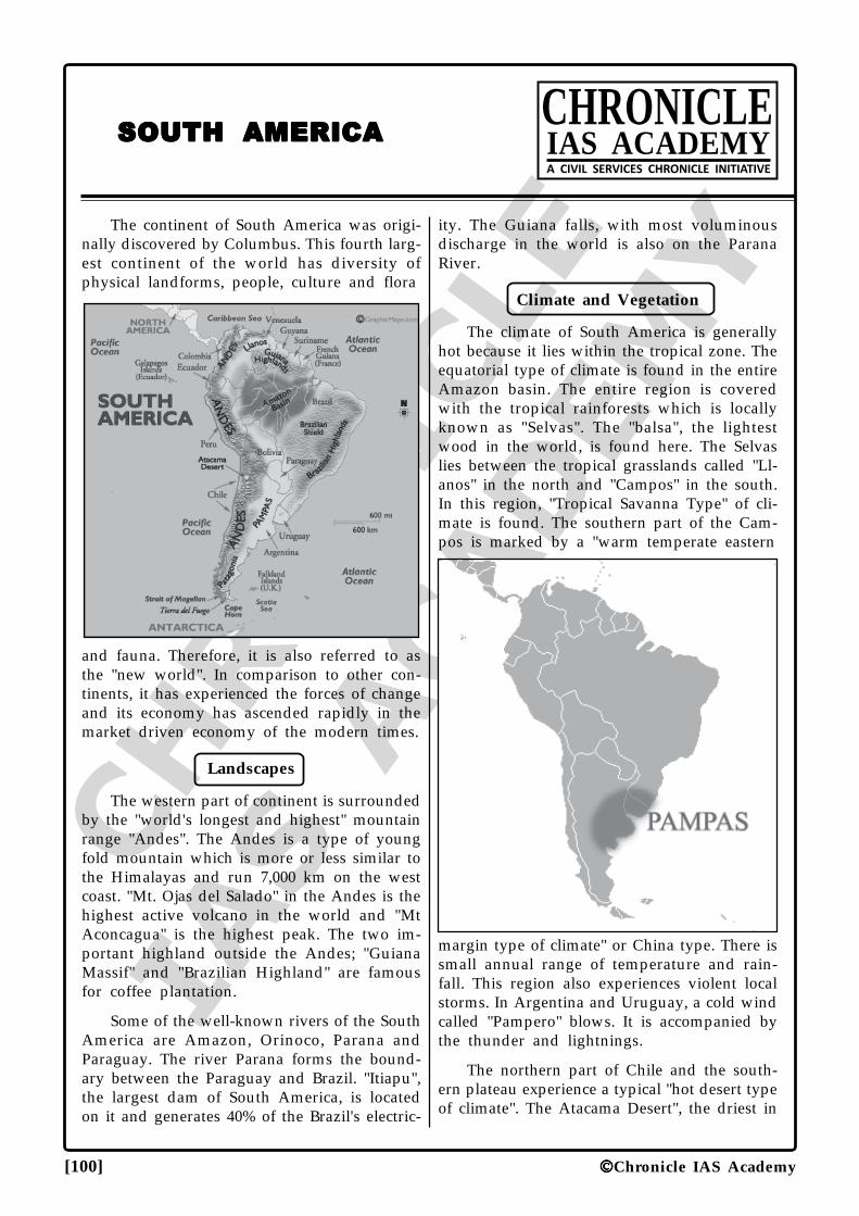
CHRO
NICLE
IAS ACADEM
Y
[100] Chronicle IAS Academy
SOUTH AMERICASOUTH AMERICASOUTH AMERICASOUTH AMERICASOUTH AMERICACHRONICLEIAS ACADEMYA CIVIL SERVICES CHRONICLE INITIATIVE
The continent of South America was origi-nally discovered by Columbus. This fourth larg-est continent of the world has diversity ofphysical landforms, people, culture and flora
and fauna. Therefore, it is also referred to asthe "new world". In comparison to other con-tinents, it has experienced the forces of changeand its economy has ascended rapidly in themarket driven economy of the modern times.
Landscapes
The western part of continent is surroundedby the "world's longest and highest" mountainrange "Andes". The Andes is a type of youngfold mountain which is more or less similar tothe Himalayas and run 7,000 km on the westcoast. "Mt. Ojas del Salado" in the Andes is thehighest active volcano in the world and "MtAconcagua" is the highest peak. The two im-portant highland outside the Andes; "GuianaMassif" and "Brazilian Highland" are famousfor coffee plantation.
Some of the well-known rivers of the SouthAmerica are Amazon, Orinoco, Parana andParaguay. The river Parana forms the bound-ary between the Paraguay and Brazil. "Itiapu",the largest dam of South America, is locatedon it and generates 40% of the Brazil's electric-
ity. The Guiana falls, with most voluminousdischarge in the world is also on the ParanaRiver.
Climate and Vegetation
The climate of South America is generallyhot because it lies within the tropical zone. Theequatorial type of climate is found in the entireAmazon basin. The entire region is coveredwith the tropical rainforests which is locallyknown as "Selvas". The "balsa", the lightestwood in the world, is found here. The Selvaslies between the tropical grasslands called "Ll-anos" in the north and "Campos" in the south.In this region, "Tropical Savanna Type" of cli-mate is found. The southern part of the Cam-pos is marked by a "warm temperate eastern
margin type of climate" or China type. There issmall annual range of temperature and rain-fall. This region also experiences violent localstorms. In Argentina and Uruguay, a cold windcalled "Pampero" blows. It is accompanied bythe thunder and lightnings.
The northern part of Chile and the south-ern plateau experience a typical "hot desert typeof climate". The Atacama Desert", the driest in
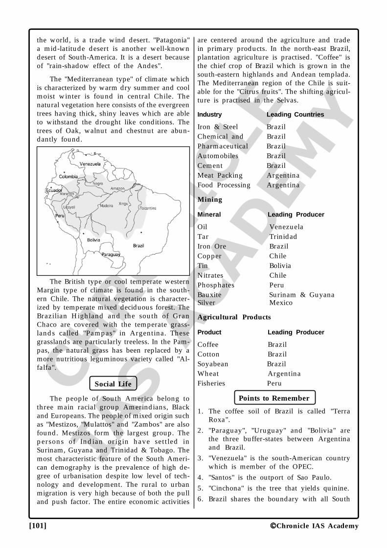
CHRO
NICLE
IAS ACADEM
Y
[101] Chronicle IAS Academy
the world, is a trade wind desert. "Patagonia"a mid-latitude desert is another well-knowndesert of South-America. It is a desert becauseof "rain-shadow effect of the Andes".
The "Mediterranean type" of climate whichis characterized by warm dry summer and coolmoist winter is found in central Chile. Thenatural vegetation here consists of the evergreentrees having thick, shiny leaves which are ableto withstand the drought like conditions. Thetrees of Oak, walnut and chestnut are abun-dantly found.
The British type or cool temperate westernMargin type of climate is found in the south-ern Chile. The natural vegetation is character-ized by temperate mixed deciduous forest. TheBrazilian Highland and the south of GranChaco are covered with the temperate grass-lands called "Pampas" in Argentina. Thesegrasslands are particularly treeless. In the Pam-pas, the natural grass has been replaced by amore nutritious leguminous variety called "Al-falfa".
Social Life
The people of South America belong tothree main racial group Amerindians, Blackand Europeans. The people of mixed origin suchas "Mestizos, "Mulattos" and "Zambos" are alsofound. Mestizos form the largest group. Thepersons of Indian origin have settled inSurinam, Guyana and Trinidad & Tobago. Themost characteristic feature of the South Ameri-can demography is the prevalence of high de-gree of urbanisation despite low level of tech-nology and development. The rural to urbanmigration is very high because of both the pulland push factor. The entire economic activities
are centered around the agriculture and tradein primary products. In the north-east Brazil,plantation agriculture is practised. "Coffee" isthe chief crop of Brazil which is grown in thesouth-eastern highlands and Andean templada.The Mediterranean region of the Chile is suit-able for the "Citrus fruits". The shifting agricul-ture is practised in the Selvas.
Industry Leading Countries
Iron & Steel BrazilChemical and BrazilPharmaceutical BrazilAutomobiles BrazilCement BrazilMeat Packing ArgentinaFood Processing Argentina
Mining
Mineral Leading Producer
Oil VenezuelaTar TrinidadIron Ore BrazilCopper ChileTin BoliviaNitrates ChilePhosphates PeruBauxite Surinam & GuyanaSilver Mexico
Agricultural Products
Product Leading Producer
Coffee BrazilCotton BrazilSoyabean BrazilWheat ArgentinaFisheries Peru
Points to Remember
1. The coffee soil of Brazil is called "TerraRoxa".
2. "Paraguay", "Uruguay" and "Bolivia" arethe three buffer-states between Argentinaand Brazil.
3. "Venezuela" is the south-American countrywhich is member of the OPEC.
4. "Santos" is the outport of Sao Paulo.5. "Cinchona" is the tree that yields quinine.6. Brazil shares the boundary with all South
CHRO
NICLE
IAS ACADEM
Y
[102] Chronicle IAS Academy
American countries except "Chile" and "Ec-uador".
7. South American countries in descendingorder of size; Brazil-Argentina-Peru-Colum-bia.
8. "Sucre" is the legal capital of Bolivia.9. "La Paz" is the administrative capital of
Bolivia.10. Punta Arenas and Chile are the southern-
most inhabited cities of the world.11. French, Italian, Portuguese and Spanish are
the Latin languages.12. "Portuguese" is the official language of Bra-
zil.13. "Chuquicamata" is the copper capital of the
world.14. "Brazil" is the country with the largest re-
serve of hardwood.15. World's largest exploitable reserve of copper
is found in the "Chile".16. "Minas Gerais" is the most mineral rich state
of Brazil.17. "Drake Passage" is a strait between South
America and Antarctica.18. Iquique in Atacama is the driest place on the
Earth.
19. "Colombia and Chile" are the South Ameri-can countries with coast along both Pacificand Atlantic Ocean.
20. "Titicaca" is the highest navigable lake in theworld.
21. "Brazil" is the only country through whichboth equator and one of the tropics pass.
22. "Balsa" is the lightest wood that is foundonly in South-America.
23. "Sao Paulo" is the largest city of SouthAmerica.
24. Argentinean ranches are called "Estancias".
25. "Gauchos" are the people of mixed Euro-pean and American Indians ancestry whowork on cattle farms.
26. "Mt. Aconcagua" is the highest peak ofSouth America.
27. "Madeira" is the largest tributary of Ama-zon.
28. Some of the South American countries bor-dering Caribbean Sea are: "Colombia, Ven-ezuela, Guyana, Surinam, French Guianaand Brazil".
29. Caliche or Sodium Nitrate is found in"Atacama Desert".
30. "Kourou" the French satellite launching sta-tion is in "French Guiana".
31. Lake Maracaibo, famous for crude oil is inVenezuela.
32. "Alfa-Alfa" is the nutritious leguminous grassof Pampas.
33. "Angel falls" the highest in the world is on"Orinoco river of Venezuela".
34. "Pampero" is the violent cold wind in Ar-gentina and Uruguay.
35. "Pampas" is the temperate grassland of Ar-gentina.
36. "Tubarao of South Brazil" is South America'slargest steel making facility.
37. "Coffee Plantations of Brazil" are called"Fazendas".
38. "Bolivia" and "Paraguay" are the landlockedcountries of South America.
39. Bolivia is named after "Simon Bolivar".
40. Trans - Andean airways connects "BuenosAires" and "Valparaiso".
41. "Entre Rios" is also called Mesopotamia.
42. "Polygon of drought" is a term used todescribe the Brazilian North-East.
43. "Gran Chaco" is an inland plain of SouthAmerica in Bolivia, Paraguay and Argen-tina. It has warm temperate forest andgrasslands.
•••
CHRO
NICLE
IAS ACADEM
Y
[103] Chronicle IAS Academy
Landscape
The "Middle America" comprises countriesfrom Mexico to Panama and all the islands ofCaribbean Sea. The mainland of the MiddleAmerica which is the site of development ofthe Meso-American culture is also a zone ofconflict. It chiefly consists of two regions"Mexico" and "Central America" which includeswithin it seven countries Guatemala, Belize, ElSalvador, Honduras, Nicaragua, Costa Rica andPanama. The size and population of Mexicoexceed the combined population and area ofall others Middle American countries put to-gether.
Social Features
About 60 per cent of all the Mexicans are"Mestizos" 25 per cent are Americans whileonly 9 per cent are Armedians. In Mexico, twoway exchange of cultural change has occurred.Here, Mexican Amerindians have been Euro-peanized while the modern Mexico is stronglyindianised. Some of the distinctive Mexicanmodes of dress, cuisine and architectural stylealso reflect Amerindian contribution. The larg-est number of Mexicans are Roman Catholics.
Climate and Vegetartion
Over a half of Mexico lies to the North ofTropic of Cancer and is dominated by desertand steppe climatic type. The south of theTropic of Cancer is inhabited by huge popula-tion. Mexico's climate is marked by dryness par-ticularly in the mountain-flanked north. It isamong the top five producers of agriculturalproducts such as sugarcane, citrus fruits, cof-fee and corn. The central Mexico region is toohigh for Tierra Templada crops. The prevailingTierra Fria environment allows only such cropswhich are resistant to frost damage. In thenorthern, Mexico the "steppe" or "desert" typeof climate is found. "Lumbering" is importanteconomic activity here. The Gulf Tropics re-gion of Mexico is the main producer of planta-tion crops including Cocoa, Sugarcane andrubber.
MIDDLE AMERICAMIDDLE AMERICAMIDDLE AMERICAMIDDLE AMERICAMIDDLE AMERICACHRONICLEIAS ACADEMYA CIVIL SERVICES CHRONICLE INITIATIVE
Minerals
The physiographic diversity of Mexico hasalso provided to Mexico, vast mineral wealth.Antimony, petroleum and sulphur are the chiefminerals of Mexico. Mexico still exports a ma-jor share of world's silver apart from copper,zinc and lead. The yearly rate of growth ofMexican population is nearly 2.3% and it isexpected that its population will double by 2025.
Important Central American States
Guatemala
It became republic in "1839" and it is themost populated of the Central American coun-tries. Most of the population belongs to theIndian and Mestizo origin. There has been arebellion against the military backed rule. Cot-ton and coffee remain the major sources of in-come. A fairly diversified agriculture, exploit-able timber resources, vast deposit of nickel,etc. Are the hope of future growth.
Belize
It became independent in 1981. English isa lingua franca here. More than half of thepopulation is "Creoles" or English speaking blackwho are found mostly in the coastal region.Sugar is a principal export item. In 1859, atreaty was signed between Britain and Guate-mala delineating the territorial boundary ofBelize.
Honduras
There 90% of the population is Mestizo. Itis the poorest Central American country andthe economy is entirely based on agriculture,livestock, forestry and mining. Although Hon-duras has a democratically elected government,the military continues to wield a strong influ-ence. There is a development of light industryand tourism.
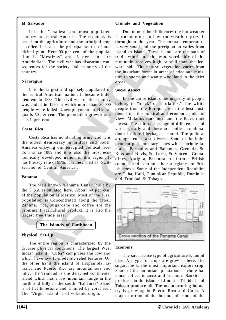
CHRO
NICLE
IAS ACADEM
Y
[104] Chronicle IAS Academy
El Salvador
It is the "smallest" and most populatedcountry in central America. The economy isbased on the agriculture and the principal cropis coffee. It is also the principal source of me-dicinal gum. Here 90 per cent of the popula-tion is "Mestizos" and 5 per cent areAmerindians. The civil war has disastrous con-sequences for the society and economy of thecountry.
Nicaragua
It is the largest and sparsely populated ofthe central American nation. It became inde-pendent in 1838. The civil war of the countrywas ended in 1990 in which more than 30,000people were killed. Unemployment in Nicara-gua is 50 per cent. The population growth rateis 3.1 per cent.
Costa Rica
Costa Rica has no standing army and it isthe oldest democracy in middle and SouthAmerica enjoying uninterrupted political free-dom since 1889 and it is also the most eco-nomically developed nation in this region. Ithas literacy rate of 95%. It is described as "Swit-zerland of Central America".
Panama
The well known 'Panama Canal" built bythe U.S.A is situated here. About 60 per centof the population is Mestizo. Most of the ruralpopulation is Concentrated along the canal.Banana, rice, sugarcane and coffee are theprominent agricultural product. It is also thelargest free trade area.
The Islands of Caribbean
Physical Set-Up
The entire region is characterized by thediverse physical conditions. The largest WestIndian island; "Cuba" comprises the lowlandwhich have low to moderate relief features. Onthe other hand the island of Hispaniola, Ja-maica and Puerto Rico are mountainous andhilly. The Trinidad is the detached continentalisland which has a low mountain range in thenorth and hilly in the south. "Bahamas" islandis of flat limestone and rimmed by coral reef.The "Virgin" island is of volcanic origin.
Climate and Vegetation
Due to maritime influences the hot weatheris uncommon and warm weather prevailthroughout the year. The annual temperatureis very small and the precipitation varies fromisland to island. These islands are the path oftrade wind and the windward side of themountain receives high rainfall than the lee-ward side. The natural vegetation varies fromthe luxuriant forest in areas of adequate mois-ture to sparse and scanty woodland in the drierareas.
Social Aspect
In the entire islands the majority of peoplebelong to "black" or "mulattos." The whitepeople from the Europe are in the best posi-tions from the political and economic point ofview. Mulattos rank next and the Black ranklowest. The cultural heritage of different islandvaries greatly and there are endless combina-tion of cultural heritage is found. The politicalarrangement is also diverse. Some of the inde-pendent parliamentary states which include Ja-maica, Barbados and Bahamas, Grenada, St.Kitts and Nevis, St. Lucia, St Vincent, Grena-dines, Antigua, Barbuda are former Britishcolonies and continue their allegiance to Brit-ish crown. Some of the Independent Republicsare Cuba, Haiti, Dominican Republic, Dominicaand Trinidad & Tobago.
Economy
The subsistence type of agriculture is foundhere. All types of crops are grown - here. Thesugarcane is the most important export crop.Some of the important plantations include ba-nana, coffee, tobacco and coconut. Bauxite isproduces in the island of Jamaica. Trinidad andTobago produce oil. The manufacturing indus-try is growing in Puerto Rico and Cuba. Amajor portion of the income of some of the
CHRO
NICLE
IAS ACADEM
Y
[105] Chronicle IAS Academy
important islands comes from tourism. "Baha-mas Island" is a well known tourism centre."The Greater Antilles" comprises of four largestCaribbean islands. It includes Cuba, JamaicaHispaniola (containing the nations of Haiti andthe Dominican Republic) and Puerto Rico.
Barbados
It is the easternmost island of West Indies.It is the most densely populated and all theavailable land is under irrigation. Sugarcane iscultivated on 90 per cent of the cultivable land.It became independent from the Britishers in1962. In the entire Caribbean country, Barba-dos is most educated and had a tolerant popu-lation. Agriculture accounts for the 6 per centof the GDP while the service sector for nearly"80%". The main exports of Barbados are elec-trical component, petroleum products andchemicals.
Points to Remamber
1. "Belize" is the only Central American repub-lic that does not have a Pacific coastline.
2. "El Salvador" is the only Central Americancountry not having an Atlantic coastline.
3. "Belize" is the country which is also called"British Honduras".
4. "Sugarcane" is the largest export of most ofthe Caribbean islands.
5. "Barbados" is the most densely populatedcountry of the central America.
6. The arranged order of Central Americancountries from North to south: - Belize -Guatemala - Honduras - El Salvador - Nica-
ragua - Costa Rica - Panama.
7. The "Panama city" is the only capital city ofcentral American country having a costallocation.
8. "Panama" was one of the provinces of Co-lombia.
9. The "Nicaragua" is well - known a theMosquito Coast.
10. "Belize city" is the old capital of Belize.
11. "Chemicals" is the largest export of PuertoRico.
12. "Balboa" and "Colon" are the cities on thePacific and Atlantic ends respectively.
13. The capital of Costa Rica, Honduras and ElSalvador are San Jose, Tegucigalpa and SanSalvador.
14. The Republic of Haiti and Dominican Re-public share the island of Hispaniola.
15. "El Salvador" is the most populated CentralAmerican republic. It is also the smallestCentral American nation.
16. "Mexico city" is the largest urban agglom-eration in the world.
17. "Mexico" is the only Middle American coun-try where Olympics were held in 1968.
18. "Chihuahua'' in Mexico is one of the largestsilver mines in the world.
19. "Barbados" was the island of Lesser Antilleswhich was once under British rule.
20. "Mexico" is the largest country of the Cen-tral America.
21. "Cuba" is well known for producing sugar-cane, cigar and boxes.
•••
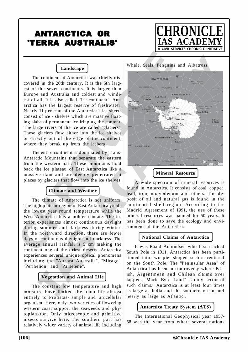
CHRO
NICLE
IAS ACADEM
Y
[106] Chronicle IAS Academy
Landscape
The continent of Antarctica was chiefly dis-covered in the 20th century. It is the 5th larg-est of the seven continents. It is larger thanEurope and Australia and coldest and windi-est of all. It is also called "Ice continent". Ant-arctica has the largest reserve of freshwater.Nearly 11 per cent of the Antarctica's ice sheetsconsist of ice - shelves which are massive float-ing slabs of permanent ice fringing the content.The large rivers of the ice are called "glaciers".These glaciers flow either into the ice shelvesor directly out of the edge of the continent,where they break up from the iceberg.
The entire continent is dominated by Trans-Antarctic Mountains that separate the easternfrom the western part. These mountains holdback the ice plateau of East Antarctica like amassive dam and are deeply penetrated atplaces by glaciers that flow into the ice shelves.
Climate and Weather
The climate of Antarctica is not uniform.The high plateau region of East Antarctica yieldsthe lowest year round temperature while theWest Antarctica has a milder climate. The in-terior experiences almost continuous daylightduring summer and darkness during winter.In the northward direction, there are fewerdays of continuous daylight and darkness. Theaverage annual rainfall is 5 cm making thecontinent one of the driest deserts. Antarcticaexperiences several unique optical phenomenaincluding the "Aurora Australis", "Mirage","Perihelion" and "Parselene".
Vegetation and Animal Life
The constant low temperature and highmoisture have limited the plant life almostentirely to Protistas- simple and unicellularorganism. Here, only two varieties of floweringwestern coast support the seaweeds and phy-toplankton. Only microscopic and primitiveinsects survive here. The southern part hasrelatively wider variety of animal life including
ANTANTANTANTANTARARARARARCTICA ORCTICA ORCTICA ORCTICA ORCTICA OR
'TERRA 'TERRA 'TERRA 'TERRA 'TERRA AAAAAUSTRALIS'USTRALIS'USTRALIS'USTRALIS'USTRALIS'
CHRONICLEIAS ACADEMYA CIVIL SERVICES CHRONICLE INITIATIVE
Whale, Seals, Penguins and Albatross.
Mineral Resource
A wide spectrum of mineral resources isfound in Antarctica. It consists of coal, copper,lead, iron, molybdenum and others. The de-posit of oil and natural gas is found in thecontinental shelf region. According to theMadrid Agreement of 1991, the use of thesemineral resources was banned for 50 years. Ithas been done to save the ecology and envi-ronment of the Antarctica.
National Claims of Antarctica
It was Roald Amundsen who first reachedSouth Pole in 1911. Antarctica has been parti-tioned into two pie- shaped sectors centeredon the South Pole. The "Peninsular Area" ofAntarctica has been in controversy where Brit-ish, Argentinean and Chilean claims overlapped. "Marie Byrd Land" is only sector ofsuch claims. "Antarctica is at least four timesas large as India and the southern ocean andnearly as large as Atlantic".
Antarctica Treaty System (ATS)
The International Geophysical year 1957-58 was the year from where several nations
CHRO
NICLE
IAS ACADEM
Y
[107] Chronicle IAS Academy
started to cooperate on scientific research inAntarctica. After that several projects wereundertaken on diverse geophysical topics andthis led to the establishment of Scientific Com-mittee on Antarctica Research (SCAR). It alsoled to the development of "Antarctic Treaty" in1959. In 1983, India was admitted as the con-sultative member.
This treaty is chiefly aimed at enhancingthe cooperation in Antarctica. According to thistreaty, Antarctica should be used only for thepeaceful purposes and prohibits military activi-ties such as waste disposal and weapons Test-ing. The treaty envisages continued coopera-tion, mutual inspection of stations and exchangeof scientific personnel with the objective ofmaintaining the ecological balance. The ATShas also formulated several resolutions whichconsist of:
(1) Conservation of Antarctic marine livingresources.
(2) Protocol on environment protection.
(3) Agreed measures for conservation ofAntarctic's flora and fauna.
(4) Convention on Conservation of AntarcticSeals.
Antarctica Fact File
1. Discovery of Antarctica: It was James Cookwho first crossed the Antarctica circle butunable to discover anything. Firstly, Sir JamesClark Ross discovered the "Ross Sea", the"Victoria Island" and the "Magnetic Pole".In a race contest to South Pole, Robert FScott, and Roald Amundsen, participated.On 14th December 1911, Norwegian,Amundsen was able to beat Scott to victory.
2. Southernmost Post Office: It is situated inAntarctica and operated by a lady.
3. Aurora Australis: It is the fantastic displayof light in characteristic colour, bands andrings of various hues. It is caused by stream
of charged particles from the sun, enteringinto the earth's upper atmosphere. A moreor less similar phenomena in the northernhemisphere is called "Aurora Borealis".
4. Fastest Antarctica Crossing: It is "Trans -Antarctica" completed by Ranulph Fiennes,Oliver Shepard and Charles Burton in 1980- 82. It is also the leg of Trans - GlobeExpedition in 67 days from 28th October1980 to 11th January 1981.
5. Ozone Hole: It is the ozone - layer over thecontinent of Antarctica which was discov-ered in mid 1970s. Its corresponding annualhole was identified over the Arctic Ocean in1986. This hole is most prominent duringthe coldest seasons.
6. Land of Ice: The entire Antarctica is cov-ered with the ice sheet which is as thick as1800 metres. If all the ice of it melts, the seawould rise by 60 metres.
7. Cold - Pole: It refers to the point withlowest-mean annual temperature in eachhemisphere. In the northern hemisphere,this is at "Verkhoyansk" in north - eastSiberia, Russia. In the south hemisphere, thelowest recorded temperature has been at the"Soviet Research Station" of Vostok on theAntarctic ice plateau. "Vostok" and"Verkhoyansk" are together known as the"Cold Poles of the Earth".
8. Southern Ocean: It includes southern por-tion of India. Atlantic and Pacific ocean andis considered as a separate ocean due to itsuniform lower temperature and salt concen-tration,
9. Ross - ice - shelf: It is the largest ice- shelfin the world which is as large as France.
10. Mt. Erebus: It is a type of active volcanowhich, along with many other volcanoes,dots the coastal and island regions.
11. Vinson Massif: It is the highest Peak inAntarctica.
•••
CHRO
NICLE
IAS ACADEM
Y
[108] Chronicle IAS Academy
MISCELLANEOUSMISCELLANEOUSMISCELLANEOUSMISCELLANEOUSMISCELLANEOUSCHRONICLEIAS ACADEMYA CIVIL SERVICES CHRONICLE INITIATIVE
Lake Victoria: It is the largest Lake inAfrica and is the source of "White Nile". The"Lake Tana" in Ethiopia is the source of "BlueNile". Both the White and the Blue Nile meetat the capital city of Sudan, "Khartoum" fromwhere the combined stream is known as "Nile"river. It is the longest river of the world. The"Aswan dam" was built on it which forms thelargest man-made lake, "Lake Nasser".
River Zambezi: It is the largest river ofSouth Africa and natural political boundarybetween Zambia and Zimbabwe. The famous"Victoria fall" is situated on it. The "KaribaDam" of Africa is also situated on it.
River Zaire: It is only river in the world tocross the equator twice. "Boyoma or StanleyFalls" is situated on it.
Guinea-Bissau: It is the most rural coun-try in the world. In total GDP, agriculturecontributes about 60% and it is also one of thepoorest countries of the world.
Perforated State: It is type of state whosegeographical boundary completely surroundsthat of another state. For example, S. Africaencloses Lesotho and Swaziland.
Gibraltar: It is a gateway between Atlan-tic Ocean and Mediterranean Sea. The stretchbetween the steep "Rock of Gibraltar" and"Cape Ceuta" is called "Pillars of Hercules".
The Great Rift Valley: It is in Africa andruns from the south of lake Malawi to thenorthward side of Red sea and then throughGulf of Aquaba leads to Dead sea. The exten-sive volcanic activity believed to accompanycontinental rifting is exemplified by the largevolcanic mountains such as Kilimanjaro andMount Kenya.
Kalahari Desert: It is situated between the"Orange" and "Zambezi" river. The entire areahas the annual rainfall of less than 50 cm."Bushmen" is the aboriginal people of thisdesert. They use to collect water in the Ostricheggshells in dried buck stomachs. They alsouse to suck dew drops in the drier years.
Barbary State: The north-west Africancountries of Morocco, Algeria and Tunisia arecalled as Barbary States because of the region'soldest inhabitants the Berbers. These three coun-tries together constitute the "Maghreb". The re-gion "Djezira-el-Maghreb" or "Isle of West" isin recognition of Atlas Mountain rising like vastinlands on the west coast of Mediterranean Sea.
Balkans: The entire region of Balkan Pen-insula is bounded by Adriatic Aegean and Blacksea. It includes Greece, Bulgaria, Albania, Ro-mania and former Yugoslavia. Today the re-gion has fragmented and it is referred as"Balkanization" meaning disintegration.
Discovery of Antarctic: It was James Cookwho first cross the boundary of Antarctic Circle.But they were not able to see the landscape.Later on, Sir James Clark Ross discovered theRoss Sea, the Victoria Island and South Mag-netic Pole. Robert F. Scott and RonaldAmundsen were the chief contestants.Amundsen of Norway was able to beat Scottto victory on 14th December 1911.
Cold Pole: It refers to the point with thelowest mean annual temperature in each hemi-sphere. In the North hemisphere this is at"Verkhoyansk" in North-East Siberia, Russia.In the south hemisphere the lowest recordedtemperature has been at Soviet research sta-tion of Vostok on the Antarctic ice plateau.Therefore, "Vostok" and "Verkhoyansk" togethercalled the cold pole of the earth.
Bentley Subglacial Trench: It is the deep-est point in Antarctica. It is "2538" metres.
Vinson Massif: It is the highest peak inAntarctica.
Queen Maud Range: It is the longestmountain in Antarctica.
Ross-ice-Shelf: It is the largest "ice-shelf"in the world which is as large as France.
Magnetic Poles: It may be classified into"Magnetic North Pole" and the "Magnetic SouthPole", the former is located on the Prince of
CHRO
NICLE
IAS ACADEM
Y
[109] Chronicle IAS Academy
Wales Island is North Canada while the lateris situated in South Victoria land, Antarctica.
Aurora Australis: The display of southernlight is characterized by colour bands and ringsof various hues. It is caused by the streams ofcharged particles from the sun, entering intothe earth's upper atmosphere. A similar phe-nomenon in the northern hemisphere is "Au-rora Borealis".
Hamites: It refers to the people of north-ern and eastern Africa, ancient Egypt andEthiopians.
Semites: It refers to the various ancient andmodern people originating in south-west Asia.It consists of "Hebrews" and Arabs. It is alsoused as the synonymous of the Jews.
Kurds: It chiefly refers to pastoral and warlike people of Kurdistan of south-east Turkeyand Iran. They are the classic example of state-less nation. A large number of Kurds are di-vided among the nation of Iraq, Iran, Turkey,Syria and Jordon.
Tuaregs: It refers to the Berber and Hamitespeaking members of nomadic tribe of Sahara.They wear blue-dyed cloth. The dye rubs offtheir face and body are resembles with the bluecolours. Therefore, they are called "Tuaregs" orthe colour of blue.
Aborigines: The term chiefly refers to theoriginal inhabitants of any area such as Maorisof New Zealand and Bushmen of Kalahari.
Basques: It chiefly refers to the pre-Euro-pean people whose population is about 2 mil-lion and who inhabit the Pyrenees Mountainin Northern Spain and south-west France. Theyremained independent until the 19th century.
Kwajalein or Marshall Islands: It is thelargest atoll in the world where USA conductsits missile tests.
Most rainy days of the World: Mt.Waialeale Hawaii has upto 350 rainy days peryear.
Pearl Harbour: It is the US Naval base inHonolulu, the Hawaiian capital. It is the placewhere Japanese launched a bombing attackduring World War-II which was retaliated byU.S.A. by dropping atom bomb on Hiroshimaand Nagasaki.
Hawaii: It is the pacific realm of Polynesia
which consists of 130 islands. It became the5015 state of the U.S.A. Most of the HawaiianIslands are of volcanic origin and the vulcani-zation is related to the hot spot-activity. "MaunaLoa" and "Mauna Kea" could be considered astwo of the tallest mountain peak of the world.All major internal sea-route converge at Ha-waii. That's why it is called "cross-road of thePacific".
Earth Day: The "April-22" is celebrated asthe earth day to recognize beauty and riches ofthe earth. It also brought awareness about theover population, energy waste and other sig-nificant issues. It was first observed on April-22, 1970.
San Andreas Fault: It is a fracture in Earth'scrust that runs for more than 1000 kms of itslength. It cuts through the U.S mainland andmarks the meeting points of two plates e.g.Pacific and American plates. The Pacific plate,which is moving northwestward with respectto North American plate, causes earthquakesalong the fault.
Environmental Lapse Rate: It refers to thenormal rate of temperature decrease with theheight. Normally the temperature decrease atthe rate of 10ºC for every 165 metres of heightabove sea level. The higher layers of the atmo-sphere contain smaller quantities of watervapour and carbon dioxide and hence theircapacity to absorb heat energy is much lessthan that of lower layers. This is the reasonwhy Darjeeling, Nainital and Shimla is coolerthan Delhi.
Artificial Rain: The artificial rain is pro-duced by introducing tiny particles of solidcarbon dioxide or crystal of silver iodide intothe clouds at cloud temerature above 0°C bythe process called "cloud seeding". The seedingagent can be spread into a cloud from an airplane or sent up in rockets. The water-vapourin the cloud condenses around the seedingagent.
Hottest Place: It is the Death Valley ofCalifornia in USA where temperature of over49°C was recorded in July and August 1917.
Coldest Place: The Polyus Nedostypnostiof Antarctica has an extrapolated annual meantemperature of -58°C. The coldest measured an-nual temperature is -57°C. It was recorded atplateau station of Antarctic. The coldest per-manently inhabited place in the world is vil-
CHRO
NICLE
IAS ACADEM
Y
[110] Chronicle IAS Academy
lage of "Oymyakon" in Siberia of Russia.
Tornado: It refers to the strongest knownatmospheric disturbances with the wind veloc-ity exceeding 300 km/hr. It frequently occursin "Mississippi Valley" in the U.S. It is called"Twister". The U.K. has the highest frequencyof Tornadoes by area. The highest speed of Tor-nado is 450 km/hr at Texas.
Tides: The periodic phenomenon of alter-nate rise and fall in Sea levels is known as"tide". On the full moon and new moon, tidesare the highest and called "Spring Tides" while"Neap Tides" is the tides of 1st and 3rd quar-ter. Generally the tide occurs twice a day; butthe "Southampton Coast" of England experi-ences tides four times a day. It occurs at regu-lar intervals of 12 hours and 25 minutes. Thehighest tides recorded in India at Okha,Gujarat. The "Bay of Fundy" has the highesttidal range. Lakes have no tides because moon'sgravitation pull is impossible in small body ofwater such as lake.
Artesian Well: It is a type of well in whichrock layers are down folded into a basin shapeso that permeable strata may be sandwichedbetween impermeable layers. The permeablerocks only come to the surface at the edge ofthe basin. The permeable layer below it pre-vents the water from passing downwards whilethe impermeable layer on top prevents anypossibility of water escaping upward. Such astructural basin is called "aquifer". The wateris trapped in the aquifer under great pressureand when a well is bored, the pressure of waterall around the basin is sufficient to force thewater up to the bore hole so that it gushes intothe surface like a fountain. This type of well ismore valuable to man because it can be used inDesert region.
Rubber Trees: It is chiefly found in the"Amazon rainforest". Its scientific name is"Hevea Brasiliensis". Latex is collected by slash-ing tree trunks. This is a destructive system, fortrees are over trapped and destroyed for profit.With the establishment of rubber plantation insouth-east Asia, Amazon River lost its pre-eminent position.
Desert of Atacama: It is an arid type ofdesert in northern Chile that extends 960 kmsouth from Peru border. It has no vegetationand considered as the "Driest Desert of theWorld". The 400 years of drought was recorded
in 1971 in the Calama town. The only stream"Rio Loa" reaches the Pacific Ocean. It wasceded to Chile by Peru and Bolivia in 1983-84.Atacama Desert is rich in nitrates, iodine andborax.
Sao Paulo: It is the third largest urban ag-glomeration in the world after Tokyo andMexico City. It is the largest urban agglomera-tion in the southern hemisphere. It accountsfor 22% of Brazil's population and 40% of thecountry's GDP. It is also the leading industrialregion of America.
Galapagos Islands: It is situated on thenorth-west of South American mainland andis a part of Equator. The island is a home ofmany unique species of reptiles, birds andfishes.
Forwarded Capital: When a state relocatesits capital to sensitive areas, perhaps near azone of dispute with an unfriendly neighbour,in part to confirm its determination to sustainits position in that contested zone. Brasilia islocated on what has been an internal frontierwhich has yet to be conquered by still develop-ing Brazil. Another example of forward capitalis Islamabad.
Ejidos: They are the agricultural commu-nities of Mexico. The privately owned haciendaland was transferred to them after land reformwere instituted by the 1917 constitution. Likecooperative in India, these present an achieve-ment of the deal of land to the landless, but arerelatively less productive.
Panama Canal: It is connects the Atlanticwith the Pacific Ocean. It came into operationin 1913. The U.S.A. had unilateral control ofthe canal operation and was directly involvedin the administration of Panama Canal. But inthe year 2000, USA transferred the canal ad-ministration to the sovereign state of Panama.The canal measures "64.8" km from Colon onthe Atlantic till Panama city on the Pacific andhas three locks; Pedro Miguel Lock, Mira FloresRock and Gatun Lock.
Douglas Fir: It is a type of leading treespecies used in the timber industry. It is themost important trees of western USA especiallyin Washington and Oregon. The Giant Sequoiais mainly grown in California. The importanttree species here are yellow and loblolly pines.The state of British Colombia is the most im-
CHRO
NICLE
IAS ACADEM
Y
[111] Chronicle IAS Academy
portant centre of timber industry in Canada.This is the reason why Canada is the largestproducer of Newsprint while USA of Pulp andPaper.
Highway of Technology: It is also knownas "Highway 128 in eastern Massachusetts"because of the concentration of industrial unitsmanufacturing advanced electronics along theroadways.
Prince Edward Island: It is the smallestisland of Canada and the most densely popu-lated province.
Newfoundland: It was the oldest Britishcolony and the last province to join Canada in1949.
Antarctica Treaty - 1959
The International Geophysical year (1957-58) envisaged the project on diverse geophysi-cal topics and this led to the establishment of"Scientific Committee on Antarctica Research".It also led to the development of AntarcticaTreaty in 1959. India became its member in1983. The treaty envisaged that Antarcticashould be used only for the peaceful purposesand prohibits military activities. It providescontinued cooperation, exchange of scientificpersonnel and mutual inspection of stations.
•••
CHRO
NICLE
IAS ACADEM
Y
[112] Chronicle IAS Academy
WWWWWORLD FORLD FORLD FORLD FORLD FAAAAACTSCTSCTSCTSCTSCHRONICLEIAS ACADEMYA CIVIL SERVICES CHRONICLE INITIATIVE
Geographical Areas Related Countries
Eurasia Cyprus, Russia, TurkeyThe low countries Belgium, Luxemburg, HollandScandinavia Norway, Sweden, DenmarkCentral Europe Germany, Poland, Austria, CzechoslovakiaThe Balkans Hungary, Romania, Yugoslavia, Bulgaria, GreeceThe Caribbean Nicaragua, Panama, Cuba, JamaicaSouth East Asia Thailand, Vietnam, Laos, Cambodia, MalaysiaThe Baltic Finland, IcelandThe Levant Syria, Lebanon, IsraelIberian Peninsula Spain, PortugalFar East Korea, Philippines, Indonesia, China, JapanMiddle East Turkey, Iraq, Iran, Afghanistan, Saudi Arabia
Ten Most Populous Countries
No. Country Population
1. China (Asia) 1,354,040,0002. India (Asia) 1,210,193,422.3. U.S.A. (North America) 315,183,8014. Indonesia (Asia) 237,424,3635. Brazil (South America) 193,946,886.6. Pakistan (Asia 146,404,9147. Nigeria (Africa) 170,123,7408. Bangladesh (Asia) 161,083,8049. Russia (Eurasia) 142,517,67010. Japan(Asia) 127,368,088
Ten Least Populous Countries
No. Country Population
1 Dominica 67,000
2 Marshall Islands 63,0003 Saint Kitts & Nevis 38,9604 Liechtenstein 35,9045 Monaco 33,0006 San Marino 32,3867 Palau 20,0008 Tuvalu 10,0009 Nauru 10,00010 Vatican City 800
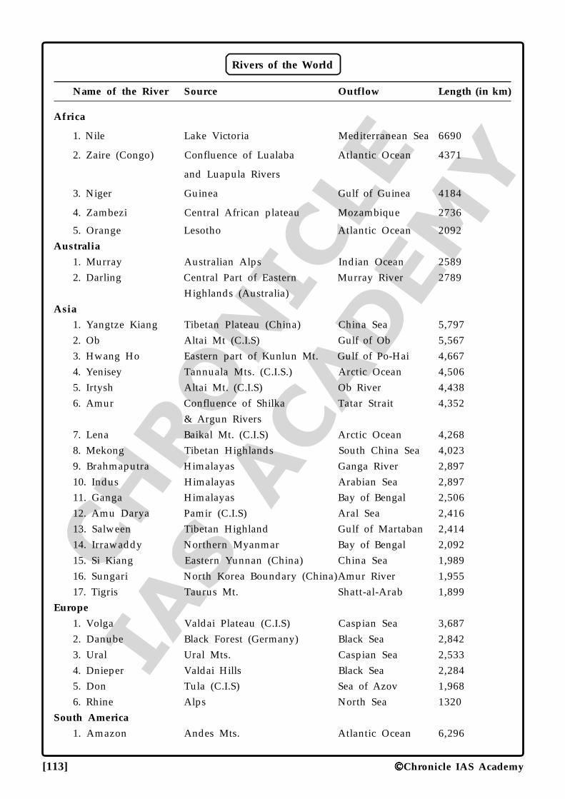
CHRO
NICLE
IAS ACADEM
Y
[113] Chronicle IAS Academy
Rivers of the World
Name of the River Source Outflow Length (in km)
Africa
1. Nile Lake Victoria Mediterranean Sea 6690
2. Zaire (Congo) Confluence of Lualaba Atlantic Ocean 4371
and Luapula Rivers
3. Niger Guinea Gulf of Guinea 4184
4. Zambezi Central African plateau Mozambique 2736
5. Orange Lesotho Atlantic Ocean 2092Australia
1. Murray Australian Alps Indian Ocean 25892. Darling Central Part of Eastern Murray River 2789
Highlands (Australia)Asia
1. Yangtze Kiang Tibetan Plateau (China) China Sea 5,7972. Ob Altai Mt (C.I.S) Gulf of Ob 5,5673. Hwang Ho Eastern part of Kunlun Mt. Gulf of Po-Hai 4,6674. Yenisey Tannuala Mts. (C.I.S.) Arctic Ocean 4,5065. Irtysh Altai Mt. (C.I.S) Ob River 4,4386. Amur Confluence of Shilka Tatar Strait 4,352
& Argun Rivers7. Lena Baikal Mt. (C.I.S) Arctic Ocean 4,2688. Mekong Tibetan Highlands South China Sea 4,0239. Brahmaputra Himalayas Ganga River 2,89710. Indus Himalayas Arabian Sea 2,89711. Ganga Himalayas Bay of Bengal 2,50612. Amu Darya Pamir (C.I.S) Aral Sea 2,41613. Salween Tibetan Highland Gulf of Martaban 2,41414. Irrawaddy Northern Myanmar Bay of Bengal 2,09215. Si Kiang Eastern Yunnan (China) China Sea 1,98916. Sungari North Korea Boundary (China)Amur River 1,95517. Tigris Taurus Mt. Shatt-al-Arab 1,899
Europe
1. Volga Valdai Plateau (C.I.S) Caspian Sea 3,6872. Danube Black Forest (Germany) Black Sea 2,8423. Ural Ural Mts. Caspian Sea 2,5334. Dnieper Valdai Hills Black Sea 2,2845. Don Tula (C.I.S) Sea of Azov 1,9686. Rhine Alps North Sea 1320
South America
1. Amazon Andes Mts. Atlantic Ocean 6,296
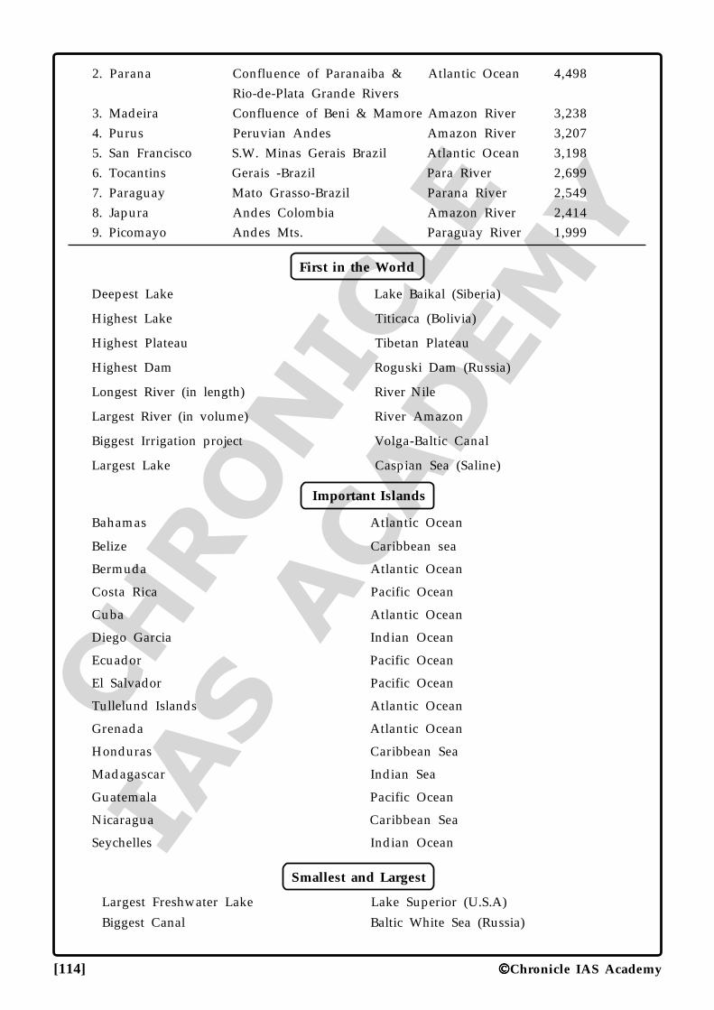
CHRO
NICLE
IAS ACADEM
Y
[114] Chronicle IAS Academy
2. Parana Confluence of Paranaiba & Atlantic Ocean 4,498Rio-de-Plata Grande Rivers
3. Madeira Confluence of Beni & Mamore Amazon River 3,2384. Purus Peruvian Andes Amazon River 3,2075. San Francisco S.W. Minas Gerais Brazil Atlantic Ocean 3,1986. Tocantins Gerais -Brazil Para River 2,6997. Paraguay Mato Grasso-Brazil Parana River 2,5498. Japura Andes Colombia Amazon River 2,4149. Picomayo Andes Mts. Paraguay River 1,999
First in the World
Deepest Lake Lake Baikal (Siberia)
Highest Lake Titicaca (Bolivia)
Highest Plateau Tibetan Plateau
Highest Dam Roguski Dam (Russia)
Longest River (in length) River Nile
Largest River (in volume) River Amazon
Biggest Irrigation project Volga-Baltic Canal
Largest Lake Caspian Sea (Saline)
Important Islands
Bahamas Atlantic Ocean
Belize Caribbean sea
Bermuda Atlantic Ocean
Costa Rica Pacific Ocean
Cuba Atlantic Ocean
Diego Garcia Indian Ocean
Ecuador Pacific Ocean
El Salvador Pacific Ocean
Tullelund Islands Atlantic Ocean
Grenada Atlantic Ocean
Honduras Caribbean Sea
Madagascar Indian Sea
Guatemala Pacific Ocean
Nicaragua Caribbean Sea
Seychelles Indian Ocean
Smallest and Largest
Largest Freshwater Lake Lake Superior (U.S.A)
Biggest Canal Baltic White Sea (Russia)
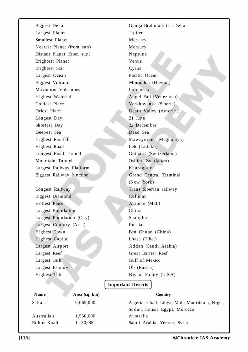
CHRO
NICLE
IAS ACADEM
Y
[115] Chronicle IAS Academy
Biggest Delta Ganga-Brahmaputra Delta
Largest Planet Jupiter
Smallest Planet Mercury
Nearest Planet (from sun) Mercury
Distant Planet (from sun) Neptune
Brightest Planet Venus
Brightest Star Cyrus
Largest Ocean Pacific Ocean
Biggest Volcano Mounaloa (Hawaii)
Maximum Volcanoes Indonesia
Highest Waterfall Angel Fall (Venezuela)
Coldest Place Verkhoyansk (Siberia)
Driest Place Death Valley (America)
Longest Day 21 June
Shortest Day 22 December
Deepest Sea Dead Sea
Highest Rainfall Mawsynram (Meghalaya)
Highest Road Leh (Ladakh)
Longest Road Tunnel Gothard (Switzerland)
Mountain Tunnel Oshimi Zu (Japan)
Largest Railway Platform Kharagpur
Biggest Railway Junction Grand Central Terminal
(New York)
Longest Railway Trans Siberian railway
Biggest Diamond Cullinan
Hottest Place Araome (Mali)
Largest Population China
Largest Population (City) Shanghai
Largest Country (Area) Russia
Highest Town Ben Chuan (China)
Highest Capital Lhasa (Tibet)
Largest Airport Jeddah (Saudi Arabia)
Largest Reef Great Barrier Reef
Largest Gulf Gulf of Mexico
Largest Estuary Ob (Russia)
Highest Tide Bay of Fundy (U.S.A)
Important Deserts
Name Area (sq. km) Country
Sahara 9,065,000 Algeria, Chad, Libya, Mali, Mauritania, Niger,Sudan,Tunisia Egypt, Morocco
Australian 1,550,000 AustraliaRub-el-Khali 1, 30,000 Saudi Arabia, Yemen, Syria
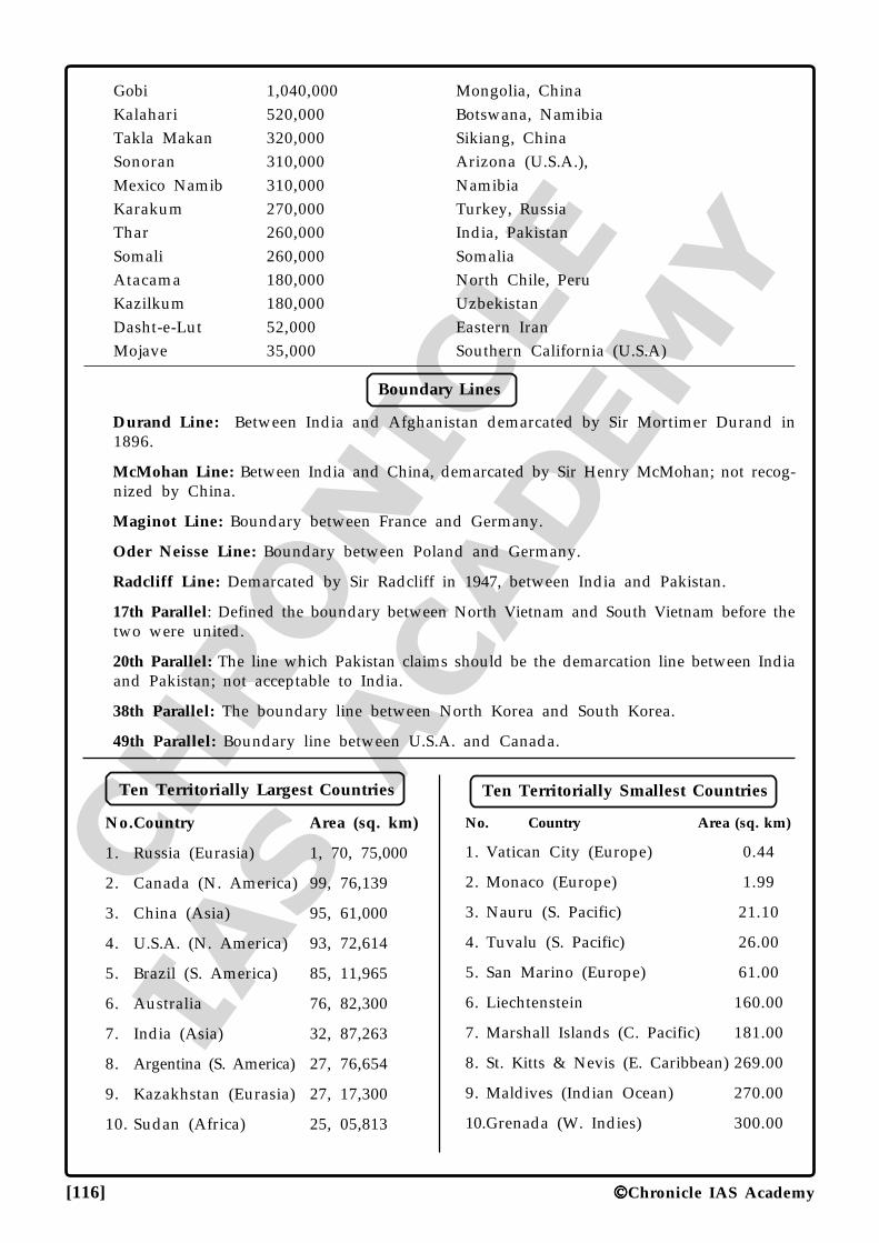
CHRO
NICLE
IAS ACADEM
Y
[116] Chronicle IAS Academy
Gobi 1,040,000 Mongolia, ChinaKalahari 520,000 Botswana, NamibiaTakla Makan 320,000 Sikiang, ChinaSonoran 310,000 Arizona (U.S.A.),Mexico Namib 310,000 NamibiaKarakum 270,000 Turkey, RussiaThar 260,000 India, PakistanSomali 260,000 SomaliaAtacama 180,000 North Chile, PeruKazilkum 180,000 UzbekistanDasht-e-Lut 52,000 Eastern IranMojave 35,000 Southern California (U.S.A)
Boundary Lines
Durand Line: Between India and Afghanistan demarcated by Sir Mortimer Durand in1896.
McMohan Line: Between India and China, demarcated by Sir Henry McMohan; not recog-nized by China.
Maginot Line: Boundary between France and Germany.
Oder Neisse Line: Boundary between Poland and Germany.
Radcliff Line: Demarcated by Sir Radcliff in 1947, between India and Pakistan.
17th Parallel: Defined the boundary between North Vietnam and South Vietnam before thetwo were united.
20th Parallel: The line which Pakistan claims should be the demarcation line between Indiaand Pakistan; not acceptable to India.
38th Parallel: The boundary line between North Korea and South Korea.
49th Parallel: Boundary line between U.S.A. and Canada.
Ten Territorially Largest Countries
No.Country Area (sq. km)
1. Russia (Eurasia) 1, 70, 75,000
2. Canada (N. America) 99, 76,139
3. China (Asia) 95, 61,000
4. U.S.A. (N. America) 93, 72,614
5. Brazil (S. America) 85, 11,965
6. Australia 76, 82,300
7. India (Asia) 32, 87,263
8. Argentina (S. America) 27, 76,654
9. Kazakhstan (Eurasia) 27, 17,300
10. Sudan (Africa) 25, 05,813
Ten Territorially Smallest Countries
No. Country Area (sq. km)
1. Vatican City (Europe) 0.44
2. Monaco (Europe) 1.99
3. Nauru (S. Pacific) 21.10
4. Tuvalu (S. Pacific) 26.00
5. San Marino (Europe) 61.00
6. Liechtenstein 160.00
7. Marshall Islands (C. Pacific) 181.00
8. St. Kitts & Nevis (E. Caribbean) 269.00
9. Maldives (Indian Ocean) 270.00
10.Grenada (W. Indies) 300.00
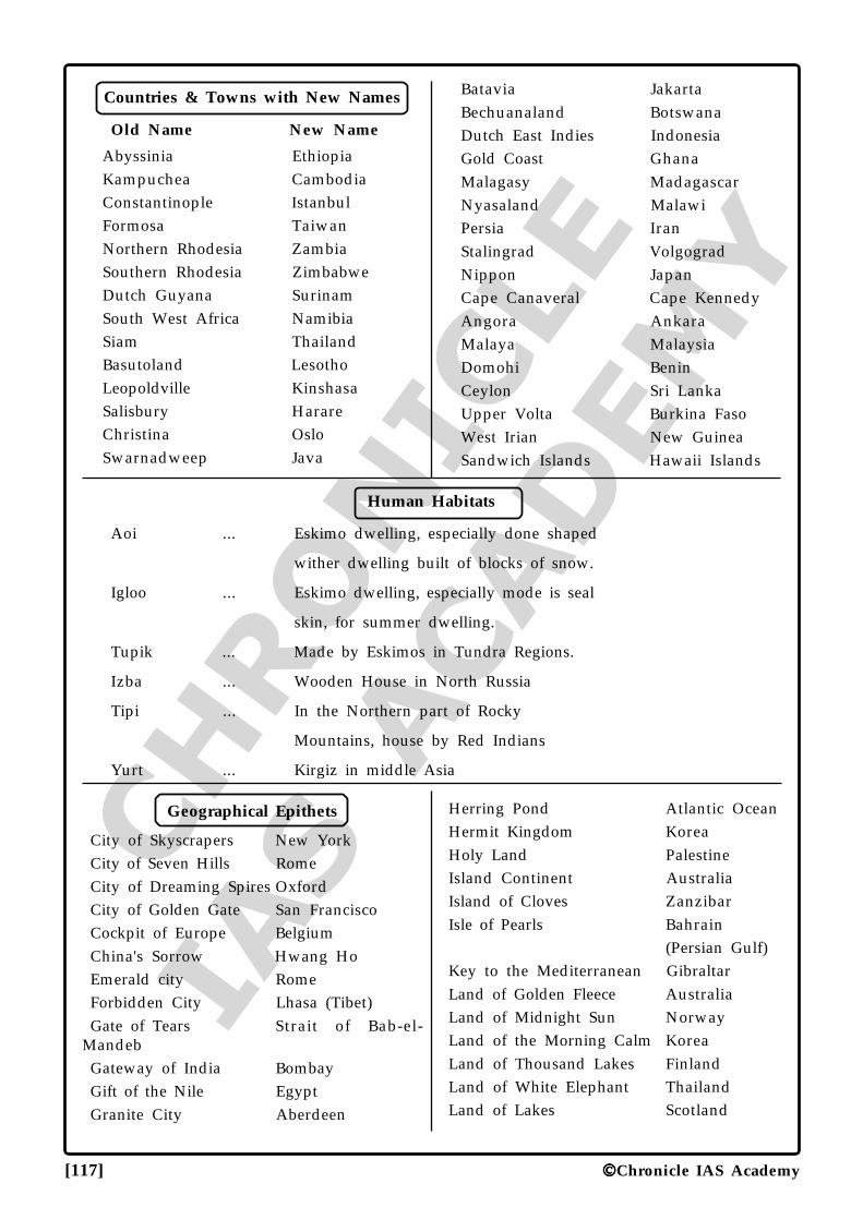
CHRO
NICLE
IAS ACADEM
Y
[117] Chronicle IAS Academy
Countries & Towns with New Names
Old Name New Name
Abyssinia EthiopiaKampuchea CambodiaConstantinople IstanbulFormosa TaiwanNorthern Rhodesia ZambiaSouthern Rhodesia ZimbabweDutch Guyana SurinamSouth West Africa NamibiaSiam ThailandBasutoland LesothoLeopoldville KinshasaSalisbury HarareChristina OsloSwarnadweep Java
Batavia JakartaBechuanaland BotswanaDutch East Indies IndonesiaGold Coast GhanaMalagasy MadagascarNyasaland MalawiPersia IranStalingrad VolgogradNippon JapanCape Canaveral Cape KennedyAngora AnkaraMalaya MalaysiaDomohi BeninCeylon Sri LankaUpper Volta Burkina FasoWest Irian New GuineaSandwich Islands Hawaii Islands
Human Habitats
Aoi ... Eskimo dwelling, especially done shaped
wither dwelling built of blocks of snow.
Igloo ... Eskimo dwelling, especially mode is seal
skin, for summer dwelling.
Tupik ... Made by Eskimos in Tundra Regions.
Izba ... Wooden House in North Russia
Tipi ... In the Northern part of Rocky
Mountains, house by Red Indians
Yurt ... Kirgiz in middle Asia
Geographical Epithets
City of Skyscrapers New YorkCity of Seven Hills RomeCity of Dreaming Spires OxfordCity of Golden Gate San FranciscoCockpit of Europe BelgiumChina's Sorrow Hwang HoEmerald city RomeForbidden City Lhasa (Tibet)Gate of Tears Strait of Bab-el-
MandebGateway of India BombayGift of the Nile EgyptGranite City Aberdeen
Herring Pond Atlantic OceanHermit Kingdom KoreaHoly Land PalestineIsland Continent AustraliaIsland of Cloves ZanzibarIsle of Pearls Bahrain
(Persian Gulf)Key to the Mediterranean GibraltarLand of Golden Fleece AustraliaLand of Midnight Sun NorwayLand of the Morning Calm KoreaLand of Thousand Lakes FinlandLand of White Elephant ThailandLand of Lakes Scotland
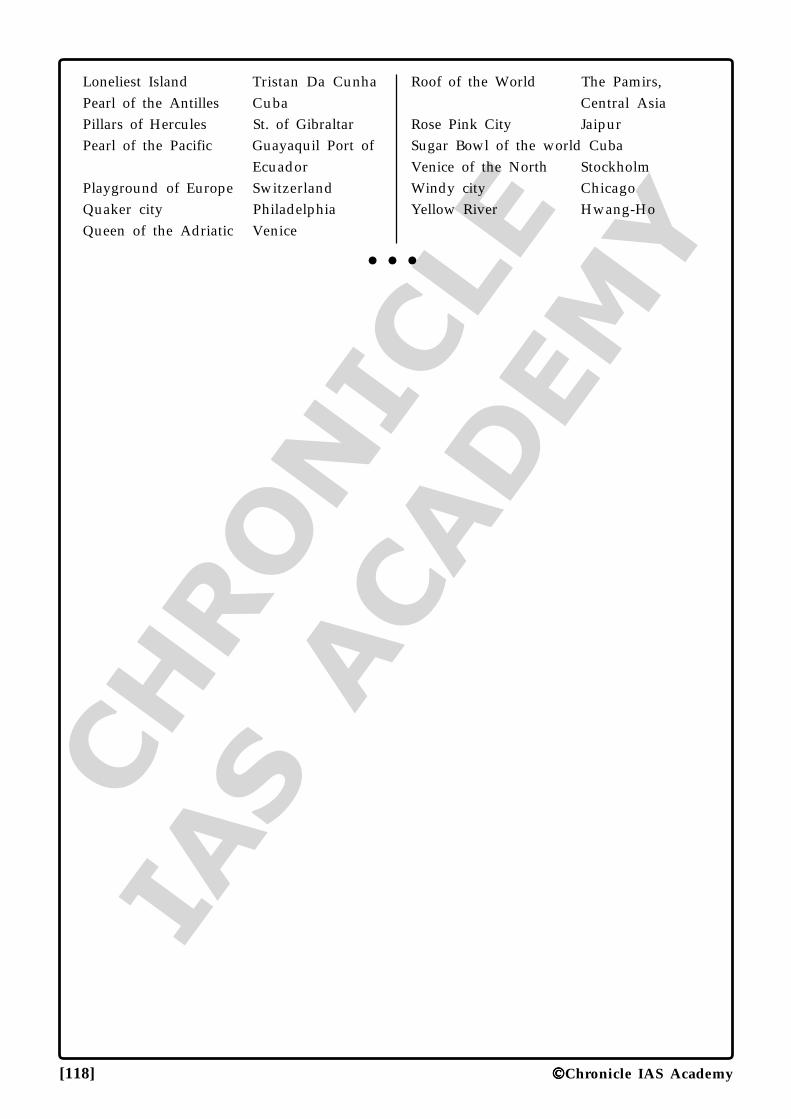
CHRO
NICLE
IAS ACADEM
Y
[118] Chronicle IAS Academy
Loneliest Island Tristan Da CunhaPearl of the Antilles CubaPillars of Hercules St. of GibraltarPearl of the Pacific Guayaquil Port of
EcuadorPlayground of Europe SwitzerlandQuaker city PhiladelphiaQueen of the Adriatic Venice
Roof of the World The Pamirs,Central Asia
Rose Pink City JaipurSugar Bowl of the world CubaVenice of the North StockholmWindy city ChicagoYellow River Hwang-Ho
•••
Geography 1©Chronicle IAS Academy
1. Match the following:A. Onges 1. Little Nicobar
B. Jarawas 2. Middle & South Andaman
C. Santineles 3. Sentinel Island
D. Shompen 4. Great Nicobar
Codes:(a) A-1, B-2, C-3, D-4
(b) A-4, B-3, C-2, D-1
(c) A-1, B-4, C-3, D-2
(d) A-1, B-2, C-4, D-3
2. Concerning the development of Govt. of India,in introducing Railway line in the tough re-gions of strategic importance, which of thesestatements are not true?1. A rail line from Baramulla to Anantnag is
the Kashmir valley has started working.
2. There is a plan of rail line from valley toJammu through Banihal pass.
3. The rail lines through Banihal pass havethe longest rail tunnel of India.
(a) All (b) Only 1
(c) Only 2 (d) None
3. Which of the following statements is NOT COR-RECT?(a) Krishna Ganga is tributary of River Jhelum.
(b) Pong reservoir is on river Beas.
(c) Ukai reservoir is on river Narmada.
(d) Wular Lake is an Oxbow lake on riverJhelum.
4. The Second Green Revolution is urgently neededin India, and it is to be brought about by:(a) More technology, hybrids, genetically modi-
fied crops and more intensive irrigation.
(b) Natural farming, organic fertilizers, indig-enous crops including pulses and coarsecereals.
(c) More credit outflow to the farmers andtechno-functional awareness among thefarmers regarding their land and agricul-
GEOGRAPHY SAMPLEGEOGRAPHY SAMPLEGEOGRAPHY SAMPLEGEOGRAPHY SAMPLEGEOGRAPHY SAMPLE
QUESTIONSQUESTIONSQUESTIONSQUESTIONSQUESTIONS
tural inputs.
(d) More budgetary allocations and increasedemphasis over self sufficiency in grain pro-duction.
5. Which one of the following is correct?(a) Nathu La pass lies in the Chumbi Valley.
(b) Shipki La lies in the Indus Valley.
(c) The alluvial Plain between the Yamuna atDelhi and the Bay of Bengal has a drop ofonly 100 metres in elevation.
(d) The Cardamom hills lying in the South arethe continuation of the Eastern Ghats.
6. According to National Disaster ManagementAuthority, the critical areas of concern for themanagement of earthquakes in India includethe:1. inadequate attention to structural mitiga-
tion measures in the engineering educationsyllabus;
2. absence of systems of licensing of engineers;
3. absence of earthquake-resistant features innon-engineered construction in suburbanand rural areas;
4. lack of formal training among profession-als in earthquake-resistant constructionpractices
(a) 1, 2 and 3. (b) 1 and 3.
(c) 1, 3 and 4. (d) 1, 2, 3 and 4.
7. Match the following soil horizons with theirdefining characteristics:
Soil Horizon CharacteristicA. Horizon B 1. Illuviated horizon or the
zone of accumulationB. Horizon C 2. Parent rockC. Horizon O 3. Surface litter
D. Horizon E 4. Eluviated horizon or thezone of leaching
5. TopsoilCodes:
A B C D(a) 1 2 3 4
Geography
CHRO
NICLE
IAS A
CADEM
Y
2
(b) 1 2 5 4(c) 5 4 1 2(d) 5 4 1 2
8. Which of the following statements regardingEl-Nino are correct?A. El-Nino is a complex weather system that
appears once every three to seven years.
B. The system involves oceanic and atmo-spheric phenomena with the appearanceof cold currents off the coast of Peru.
C. The word El-Nino means 'Child Christ'because this current appears around Christ-mas in December and decreases the inten-sity of the ongoing winter season.
D. El-Nino in India is used for forecasting longrange monsoon rainfall.
Codes:(a) A, B and D
(b) A, C and D
(c) B, C and D
(d) A and D
9. Read the following characteristics of a part ofatmosphere and recognize the region:1. It extends up to a height of 80 km.
2. In this layer, temperature decreases withthe increase in altitude.
3. Temperature reaches up to minus 100°C atthe height of 80 km.
Codes:(a) Troposphere
(b) Stratosphere
(c) Mesosphere
(d) Ionosphere
10. South Sudan shares boundary with which ofthe following country.(a) Eritrea (b) Chad
(c) Tanzania (d) Kenya
11. Which one of the following refers to the pro-cess of a city expanding and accommodatingthe neighbouring villages and communities?(a) Urbanization
(b) Over-urbanization
(c) Sub-urbanisation
(d) Semi-urbanisation
12. Consider the following statements1. The upper crust of the earth called SiAl
has an average density of 3.0
2. The lower part called SiMa has an averagedensity of 4.0
Which is/are incorrect?(a) 1 only (b) 2 only
(c) Both 1 and 2 (d) Neither 1 nor 2
13. Read the following statements:1. There is so much difference in the length of
degrees of longitudes outside the tropicsthat they are not used for calculating dis-tances as in the case of latitudes.
2. Places east of Greenwich see the sun ear-lier and gain time w.r.t. Prime Meridian,whereas places west of Greenwich see thesun later and lose time.
3. International Date Line is an imaginarystraight line on the earth where the datechanges by exactly one day when it iscrossed.
4. A traveller crossing the date line from eastto west loses a day.
Which of the above statements are true?(a) 1, 2 and 3. (b) 1, 2 and 4.
(c) 2, 3 and 4. (d) 1, 2, 3 and 4.
14. Identify the crop by reading the following state-ments:
I. It is a tropical crop, grows well at a tem-perature between 27oC and 32oC but temp.below 16oC is harmful for the crop.
II. It requires a moderate rainfall between 30-65 cm.
III. It is rich in carbohydrates, proteins, miner-als and vitamins hence provide cheap foodto a large section of poor population.
IV. It is mainly grown in Maharashtra,Karnataka and Madhya Pradesh.
Codes:(a) Bajra
(b) Jowar
(c) Maize
(d) Ragi
Geography 3
15. The Himalayas form a highly rugged and con-tinuous stretch of high mountains and exhibitslandforms which develop when strata are in-tensely folded. Which of the followings arefound in the Himalayas?(i) Anticlinal ridges
(ii) Synclinal valleys
(iii) Recumbent folds
(iv) Nappes
Codes:(a) i, ii, iii only
(b) ii, iii, iv only
(c) i, iii, iv only
(d) All the above
16. Which one of the following pairs is not cor-rectly matched.(a) South East Central Railway : Bilaspur
(b) South - Eastern Railway: Kolkata
(c) South Central Railway : Secundrabad
(d) Southern Railway : Bengaluru
17. Glacier is a slowly moving mass or river of iceformed by the accumulation and compactionof snow on mountains or near the poles. Matchthe following glaciers with the correct Stateswhere they are located.
List I List IIA. Nubra Glacier I. SikkimB. Bhaga Glacier II. Himachal PradeshC. Rathong Glacier III. J&KD. Sona Glacier IV. Uttarakhand
Codes:(a) A-III; B-II; C-I; D-IV
(b) A-III; B-II; C-IV; D-I
(c) A-II; B-III; C-I; D-IV
(d) A-IV; B-III; C-II; D-I
18. Consider the following statements:I. The human development index (HDI) ranks
the countries based on their performancein the key areas of child health, sanitation,food, adult education and access to re-sources.
II. These rankings are based on a score be-tween 0 and 1 that a country earns fromits record in the key areas of human devel-opment.
Select the correct answer code from below:(a) Only I is correct
(b) Only II is correct
(c) Both I and II are correct
(d) Neither I not II is correct
19. In which of the following States/ Union Terri-tories, no community has been declared as aScheduled Tribe?(a) Goa, Gujarat and Uttar Pradesh
(b) Rajasthan, Tripura and West Bengal
(c) Kerala, Tamil Nadu and Maharashtra
(d) Haryana, Punjab and Pondicherry
20. Among the given factors, which have the modi-fying effect on the direction of ocean currents?(1) Prevailing wind
(2) Rotation of earth
(3) Configuration of coast line
(4) Bottom relief of the ocean.
Codes:(a) (1) & (3) (b) (1), (2) & (3)
(c) (1), (3) & (4) (d) All the above.
21. Which of the following statements regardingwatershed management is/are correct?A. Watershed management basically refers to
efficient management and conservation ofsurface and groundwater resources.
B. Watershed management aims at bringingabout balance between natural resourceson the one hand and society on the other.
C. Haryali is a watershed development projectsponsored by the Central Govt. which aimsat enabling the urban population to con-serve water.
Codes:(a) A and B only
(b) A and C only
(c) B and C only
(d) All of them
22. Which of the following states is a major rubberproducing state of India?(a) Kerala-Karnataka-Tripura -Tamil Nadu
(b) Kerala- Karnataka-Tamil Nadu - Tripura
Geography
CHRO
NICLE
IAS A
CADEM
Y
4
(c) Kerala-Tamil Nadu -Karnataka-Tripura
(d) Kerala-Tamil Nadu-Tripura-Karnataka
23. Choose the rights statements:-1. India has the largest deposits of mica while
U.S.A. is the top producer in the world.
2. India is the sixth largest consumer & im-porter of the oil in the world.
3. Russia has the largest reserves of naturalgas & fresh water in the world.
(a) All (b) 1 & 2 only
(c) 1 & 3 only (d) 2 & 3 only
24. Which among these islands in a bone of con-tention between U.K. & Argentina?(a) Spratly Island
(b) Shetland Island
(c) Falkland Island
(d) Turks & Caicos Island
25. Consider the following statements:-1. Equatorial Rainforest has highest
biodiversity
2. Corals reefs are considered rainforest of theocean & Sea
3. Amphibians are considered as a good sen-sor for Air Pollution in the region.
4. Mangroves are part of Equatorial rainforest.
Which of the statements given above are cor-rect?(a) All (b) 1, 2 & 3 only
(c) 2, 3 & 4 only (d) 1 & 4 only
❖❖❖

CH
RCH
RCH
RCH
RCH
RO
NIC
LE
ON
ICLE
ON
ICLE
ON
ICLE
ON
ICLE
IA
S
IA
S
IA
S
IA
S
IA
S AAAAACADEM
Y
CADEM
Y
CADEM
Y
CADEM
Y
CADEM
Y
Geography 1
1 (a)
2 (d)
3 (c)
4 (b)
5 (a)
6 (d)
7 (a)
8 (d)
9 (c)
10 (d)
11 (c)
12 (c)
13 (d)
CHRONICLEIAS ACADEMYA CIVIL SERVICES CHRONICLE INITIATIVE
GEOGRAPHY SAMPLE QUESTIONS(ANSWERS)
14 (b)
15 (d)
16 (d)
17 (a)
18 (b)
19 (d)
20 (d)
21 (a)
22 (d)
23 (d)
24 (c)
25 (b)
���
Geography 1©Chronicle IAS Academy
1. Which one of the following pairs is correctlymatched?
Geographical Feature Region(a) Abyssinian Plateau : Arabia
(b) Atlas Mountains : North-WesternAfrica
(c) Guiana Highlands : South-WesternAfrica
(d) Okavango Basin : Patagonia
2. Variations in the length of daytime and night-time from season to season are due to(a) the earth's rotation on its axis
(b) the earth's revolution round the sun in anelliptical manner
(c) latitudinal position of the place
(d) revolution of the earth on a tilted axis
3. The Narmada river flows to the west, whilemost other large peninsular rivers flow to theeast. Why?1. It occupies a linear rift valley.
2. It flows between the Vindhyas and theSatpuras.
3. The land slopes to the west from CentralIndia.
Select the correct answer using the codes givenbelow.(a) 1 only
(b) 2 and 3
(c) 1 and 3
(d) None
4. On the planet earth, most of the freshwaterexists as ice caps and glaciers. Out of the re-maining freshwater, the largest proportion(a) is found in atmosphere as moisture and
clouds
(b) is found in freshwater lakes and rivers
(c) exists as groundwater
(d) exists as soil moisture
GEOGRAPHY UPSCGEOGRAPHY UPSCGEOGRAPHY UPSCGEOGRAPHY UPSCGEOGRAPHY UPSC
QUESTIONSQUESTIONSQUESTIONSQUESTIONSQUESTIONS
5. The most important fishing grounds of the worldare found in the regions where(a) warm and cold atmospheric currents meet
(b) rivers drain out large amounts of freshwater into the sea
(c) warm and cold oceanic currents meet
(d) continental shelf is undulating
6. Which of the following is/are unique charac-teristic/characteristics of equatorial forests?1. Presence of tall, closely set trees with
crowns forming a continuous canopy
2. Coexistence of a large number of species
3. Presence of numerous varieties of epiphytes
Select the correct answer using the code givenbelow:(a) 1 only
(b) 2 and 3 only
(c) 1 and 3 only
(d) 1, 2 and 3
7. The annual range of temperature in the interiorof the continents is high as compared to coastalareas. What is / are the reason / reasons?1. Thermal difference between land and wa-
ter
2. Variation in altitude between continentsand oceans
3. Presence of strong winds in the interior
4. Heavy rains in the interior as compared tocoasts
Select the correct answer using the codes givenbelow.(a) 1 only
(b) 1 and 2 only
(c) 2 and 3 only
(d) 1, 2, 3 and 4
8. Which of the following is / are the character-istic/ characteristics of Indian coal?
Geography
CHRO
NICLE
IAS A
CADEM
Y
2
1. High ash content
2. Low sulphur content
3. Low ash fusion temperature
Select the correct answer using the codes givenbelow.(a) 1 and 2 only
(b) 2 only
(c) 1 and 3 only
(d) 1, 2 and 3
9. Which of the following statements regardinglaterite soils of India are correct?1. They are generally red in colour.
2. They are rich In nitrogen and potash.
3. Tiley are well-developed in Rajasthan andUP.
4. Tapioca and cashew nuts grow well onthese soils.
Select the correct answer using the codes givenbelow.(a) 1, 2 and 3
(b) 2, 3 and 4
(c) 1 and 4
(d) 2 and 3 only
10. Consider the following statements:1. Natural gas occurs in the Gondwana beds.
2. Mica occurs in abundance in Kodarma.
3. Dharwars are famous for petroleum.
Which of the statements given above is/arecorrect?(a) 1 and 2
(b) 2 only
(c) 2 and 3
(d) None
11. Consider the following crops1. Cotton
2. Groundnut
3. Rice
4. Wheat
Which of these are Kharif crops?
(a) 1 and 4
(b) 2 and 3 only
(c) 1, 2 and 3
(d) 2, 3 and 4
12. "Climate is extreme, rainfall is scanty and thepeople used to be nomadic herders."
The above statement best describes which ofthe following regions?(a) African Savannah
(b) Central Asian Steppe
(c) North American Prairie
(d) Siberian Tundra
13. Among the following States, which one has themost suitable climatic conditions for the culti-vation of a large variety of orchids with mini-mum cost of production, and can develop anexport oriented industry in this field?(a) Andhra Pradesh
(b) Arunachal Pradesh
(c) Madhya Pradesh
(d) Uttar Pradesh
14. The formation of ozone hole in the Antarcticregion has been a cause of concern. What couldbe the reason for the formation of this hole?(a) Presence of prominent tropo-spheric turbu-
lence; and inflow of chlorofluorocarbons
(b) Presence of prominent polar front andstratospheric' clouds; and inflow of chlo-rofluorocarbons
(c) Absence of polar front and stratosphericclouds; and inflow of methane and chlo-rofluorocarbons
(d) Increased temperature at polar region dueto global warming
15. Two important rivers - one with its source inJharkhand (and known by a different name inOdisha), and another, with its source in Odisha- merge at a place only a short distance fromthe coast of Bay of Bengal before flowing intothe sea. This is an important site of wildlife andbiodiversity and a protected area. Which one ofthe following could be this?(a) Bhitarkanika
(b) Chandipur-on-sea
Geography 3
(c) Gopalpur-on-sea
(d) Simlipal
16. India is regarded as a country with "Demo-graphic Dividend". This is due to(a) Its high population in the age group below
15 years
(b) Its high population in the age group of 15-64 years
(c) Its high population in the age group above65 years
(d) Its high total population
17. La Nina is suspected to have caused recentfloods in Australia. How is La Nina differentfrom El Nino?1. La Nina is characterised by unusually cold
ocean temperature in equatorial IndianOcean whereas El Nino is characterised byunusually warm ocean temperature in theequatorial Pacific Ocean.
2. El Nino has adverse effect on south-westmonsoon of India, but La Nina has no ef-fect on monsoon climate.
Which of the statements given above is/arecorrect?(a) 1 only
(b) 2 only
(c) Both 1 and 2
(d) Neither 1 nor 2
18. A person stood alone in a desert on a darknight and wanted to reach his village whichwas situated 5 km east of the point where hewas standing. He had no instruments to findthe direction but he located the polestar. Themost convenient way now to reach his villageis to walk in the(a) Direction facing the polestar
(b) Direction opposite to the polestar
(c) Direction keeping the polestar to his left
(d) Direction keeping the polestar to his right
19. Consider the following statements:1. The duration of the monsoon decreases
from southern India to northern India.
2. The amount of annual rainfall in the north-ern plains of India decreases from east towest.
Which of the statements given above is/arecorrect?(a) 1 only (b) 2 only
(c) Both 1 and 2 (d) Neither 1 nor 2
20. Which one of the following is the characteristicclimate of the Tropical Savannah Region?(a) Rainfall throughout the year
(b) Rainfall in winter only
(c) An extremely short dry season
(d) A definite dry and wet season
21. Westerlies in southern hemisphere are strongerand persistent than in northern hemisphere.Why?1. Southern hemisphere has less landmass as
compared to northern hemisphere.
2. Coriolis force is higher in southern hemi-sphere as compared to northern hemisphere
Which of-the statements given above is/arecorrect?(a) 1 only
(b) 2 only
(c) Both 1 and 2
(d) Neither 1 nor 2
22. Consider the following agricultural practices:1. Contour bunding
2. Relay cropping
3. Zero tillage
In the context of global climate change, whichof the above helps/help in carbon sequestra-tion/storage in the soil?(a) 1 and 2 only (b) 3 only
(c) 1, 2 and 3 (d) None of them
23. The lower Gangetic plain is characterized byhumid climate with high temperature through-out the year. Which one among the followingpairs of crops is most suitable for this region?(a) Paddy and cotton
(b) Wheat and Jute
(c) Paddy and Jute
(d) Wheat and cotton
24. Which of the following is the chief characteris-tic of 'mixed farming'?
Geography
CHRO
NICLE
IAS A
CADEM
Y
4
(a) Cultivation of both cash crops and foodcrops
(b) Cultivation of two or more crops in thesame field
(c) Rearing of animals and cultivation of cropstogether
(d) None of the above
25. A particular State in India has the followingcharacteristics:1. It is located on the same latitude which
passes through northern Rajasthan.
2. It has over 80% of its area under forestcover.
3. Over 12% of forest cover constitutes pro-tected Area Network in this State.
Which one among the following States has allthe above characteristics?(a) Arunachal Pradesh
(b) Assam
(c) Himachal Pradesh
(d) Uttarakhand
❖❖❖
CH
RCH
RCH
RCH
RCH
RO
NIC
LE
ON
ICLE
ON
ICLE
ON
ICLE
ON
ICLE
IA
S
IA
S
IA
S
IA
S
IA
S AAAAACADEM
Y
CADEM
Y
CADEM
Y
CADEM
Y
CADEM
Y
Geography 1
1 (b)
2 (b)
3 (a)
4 (c)
5 (c)
6 (d)
7 (a)
8 (a)
9 (c)
10 (a)
11 (b)
12 (b)
13 (b)
CHRONICLEIAS ACADEMYA CIVIL SERVICES CHRONICLE INITIATIVE
GEOGRAPHY UPSC QUESTIONS(ANSWERS)
14 (b)
15 (a)
16 (b)
17 (a)
18 (c)
19 (c)
20 (d)
21 (a)
22 (a)
23 (c)
24 (c)
25 (a)
���