geography 417/517: introduction to gis introductory materials
TRANSCRIPT

Geography 417/517: Geography 417/517: Introduction to Introduction to GISGISIntroductory MaterialsIntroductory Materials

Course TopicsCourse Topics Motivation: Why GIS?Motivation: Why GIS? Data ModelsData Models Map Projections and Map Projections and
Coordinate SystemsCoordinate Systems Data entry - DigitizingData entry - Digitizing Data entry - GPSData entry - GPS Data entry - Digital dataData entry - Digital data Image dataImage data
TablesTables Basic Spatial AnalysisBasic Spatial Analysis Raster AnalysesRaster Analyses Spatial Models and Spatial Models and
ModelingModeling Data QualityData Quality The FutureThe Future

Why does GIS matter?Why does GIS matter?
Health CareHealth Care Locate new Locate new
clinics/hospitalsclinics/hospitals
Delivery CompaniesDelivery Companies Routes and schedulesRoutes and schedules
TransportationTransportation New highwaysNew highways
ForestryForestry Where to cut, plant, or Where to cut, plant, or
buildbuild
GovernmentsGovernments Allocate fundsAllocate funds
TravelersTravelers Driving directions, hotelsDriving directions, hotels
FarmersFarmers Fertilizer and pesticidesFertilizer and pesticides

Why Learn GIS? GIS is Everywhere

Why computerize manual Why computerize manual methods?methods?
To bring together data from multiple sources (synthesis)
Analytical power measure distance, density, area overlay and buffer adjacency and proximity vicinity (neighborhood) networks visibility
Flexibility Output Quality

Why GIS?Why GIS?
Resource Resource depletion/degradationdepletion/degradation
Increased problem Increased problem complexitycomplexity
Demands by the Demands by the political bodypolitical body
Improved capabilitiesImproved capabilities Increased competitionIncreased competition
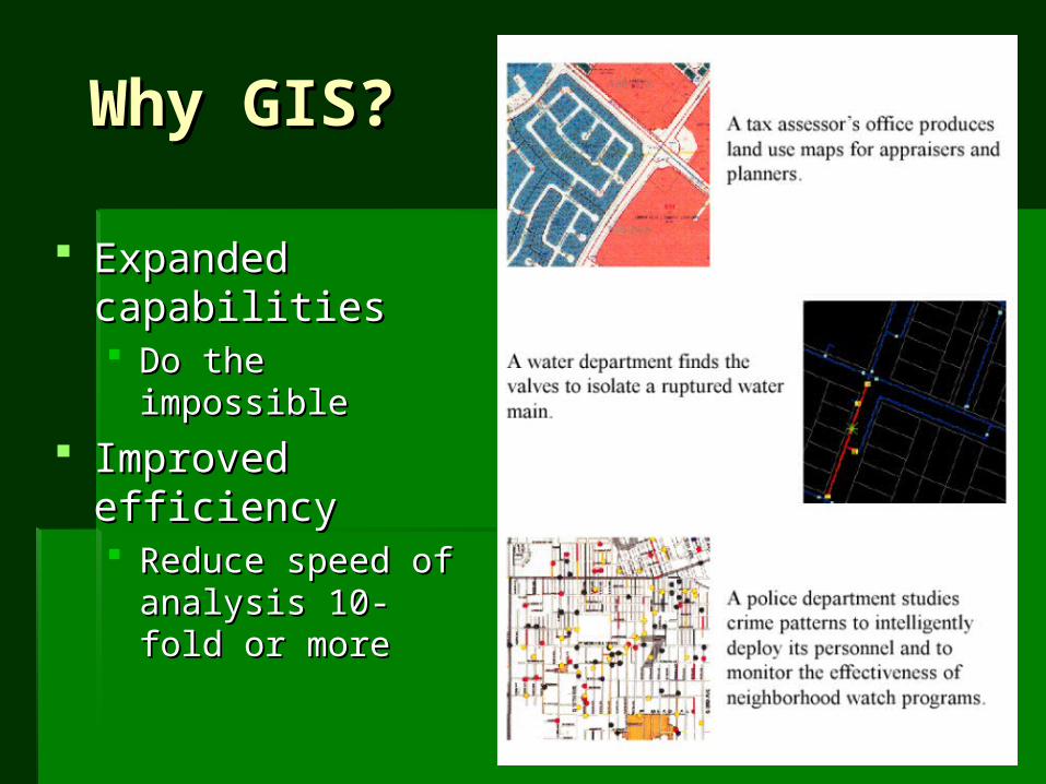
Why GIS?Why GIS?
Expanded Expanded capabilitiescapabilities Do the impossibleDo the impossible
Improved efficiencyImproved efficiency Reduce speed of Reduce speed of
analysis 10-fold or analysis 10-fold or moremore

Why GIS?Why GIS?
Convenient storage and retrieval (paper Convenient storage and retrieval (paper maps)maps) Some issues with paper mapsSome issues with paper maps
Difficult to update/editDifficult to update/edit Many types of analysis are Many types of analysis are
problematic/complexproblematic/complex e.g. overlay, proximity analysise.g. overlay, proximity analysis
Data integration is difficultData integration is difficult Large volumes of dataLarge volumes of data

Why GIS?Why GIS?
GIS providesGIS provides Data integration and standardizationData integration and standardization
Methods for managing large volumes of dataMethods for managing large volumes of data

Why GIS?Why GIS?
GIS providesGIS provides Advanced spatial analysis capabilitiesAdvanced spatial analysis capabilities

Why GIS?Why GIS?
GIS providesGIS provides Automation of repetitive tasksAutomation of repetitive tasks
Sophisticated means of communication: distribution Sophisticated means of communication: distribution and outputand output

Applications of GISApplications of GIS
Four basic categories:Four basic categories: Environmental/natural resource managementEnvironmental/natural resource management Urban and regional managementUrban and regional management Infrastructure managementInfrastructure management CommercialCommercial

Monitoring and Mapping Sea Icein near Real Time

Why GIS?
Pavement quality inventory and monitoring

Why GIS?Why GIS?
Sustaining Lobster Sustaining Lobster Fisheries in Fisheries in Penobscot BayPenobscot Bay
Why is it important?Why is it important? Fisheries stocks Fisheries stocks
dwindling lobster dwindling lobster population, an population, an economic mainstay economic mainstay with sustainable with sustainable harvestsharvests
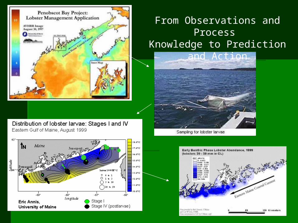
From Observations and Process Knowledge to Prediction and
Action

What is a GIS?What is a GIS? Geographic Information SystemGeographic Information System

What is a GIS?What is a GIS? Geographic Information SystemGeographic Information System

Overview of GIS Overview of GIS ArchitectureArchitecture
Spatial data are Spatial data are
organized into organized into
layerslayers
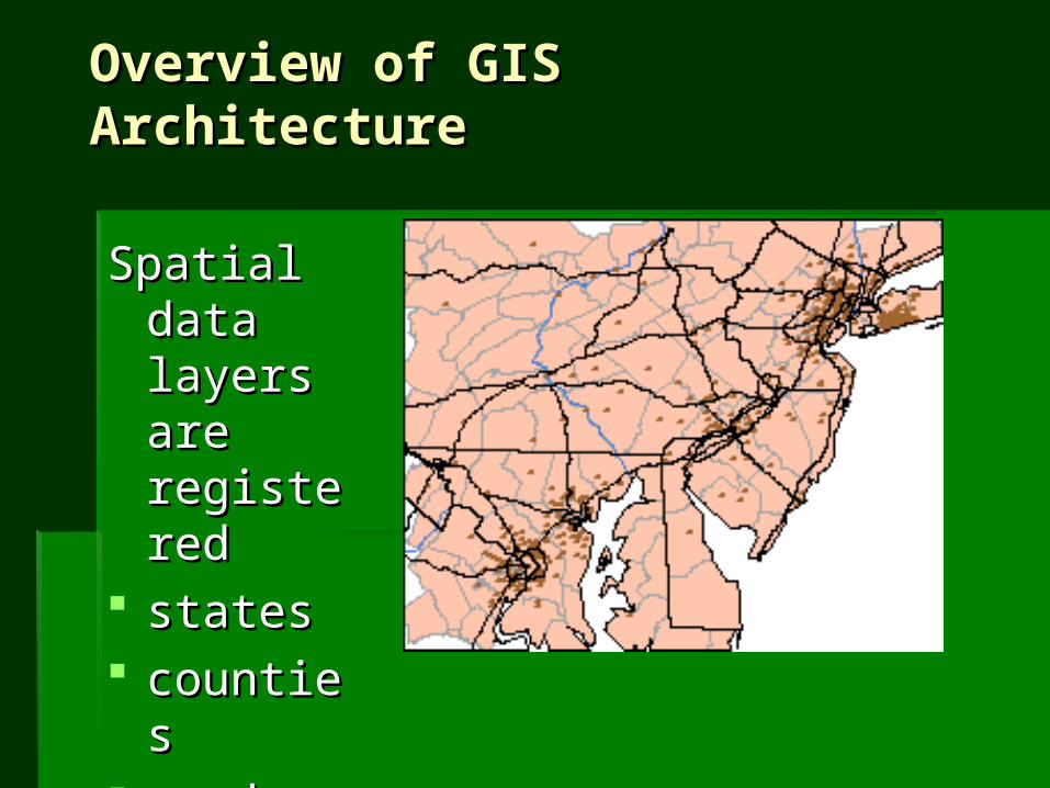
Overview of GIS Overview of GIS ArchitectureArchitecture
Spatial data Spatial data layers are layers are registeredregistered
statesstates countiescounties roadsroads riversrivers citiescities
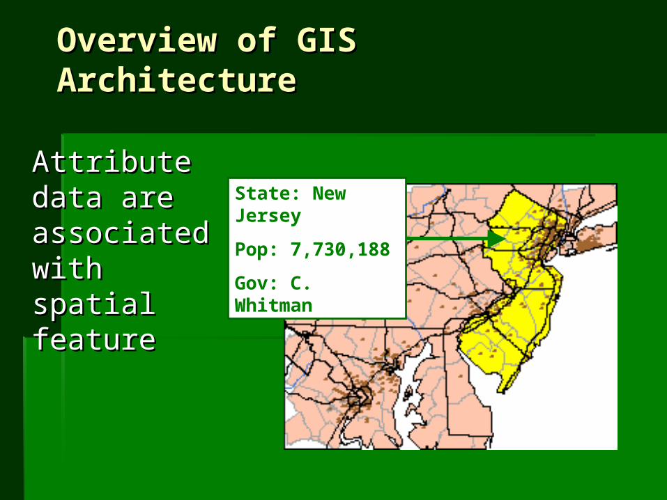
Overview of GIS Overview of GIS ArchitectureArchitecture
Attribute data Attribute data are are associated associated with spatial with spatial featurefeature
State: New Jersey
Pop: 7,730,188
Gov: C. Whitman

Overview of GIS Overview of GIS ArchitectureArchitecture
Attribute data Attribute data are stored in are stored in tablestables
State
Name Population Governor
New Jersey 7,730,188 C. Whitman
Pennsylvania 11,881,643 T. Ridge
Etc…

Spatial data and attribute table are Spatial data and attribute table are ‘‘linkedlinked’’ togethertogether
State
Name Population Governor
New Jersey 7,730,188 C. Whitman
Pennsylvania 11,881,643 T. Ridge
Etc…
Overview of GIS Overview of GIS ArchitectureArchitecture

We usually understand GIS to be We usually understand GIS to be computer-facilitated systemcomputer-facilitated system
GIS is NOT only software/hardwareGIS is NOT only software/hardware
Also includes:Also includes: Trained personnelTrained personnel Supporting InstitutionSupporting Institution Protocols for useProtocols for use
Overview of GIS ArchitectureOverview of GIS Architecture

