geog 123b lec#11
TRANSCRIPT
Chapter 18Chapter 18
The Geography of The Geography of SoilsSoils
Geosystems 5eAn Introduction to Physical Geography
Robert W. ChristophersonCharlie Thomsen

Final Exam: Correction!Final Exam: Correction!Final exam is going to take place on April 11 at Final exam is going to take place on April 11 at 2pm at the 2pm at the Alumni Hall (AH) STAGEAlumni Hall (AH) STAGEAssignment #4 is due next week.Assignment #4 is due next week.Next weekNext week I am going to cover chapters 20 and I am going to cover chapters 20 and 21. 21.
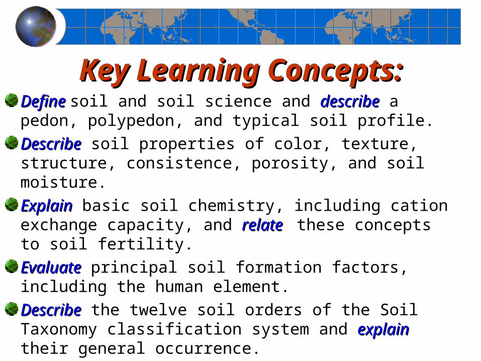
Key Learning Concepts:Key Learning Concepts:DefineDefine soil and soil science and describedescribe a pedon, polypedon, and typical soil profile.DescribeDescribe soil properties of color, texture, structure, consistence, porosity, and soil moisture.ExplainExplain basic soil chemistry, including cation exchange capacity, and relaterelate these concepts to soil fertility.EvaluateEvaluate principal soil formation factors, including the human element.DescribeDescribe the twelve soil orders of the Soil Taxonomy classification system and explainexplain their general occurrence.
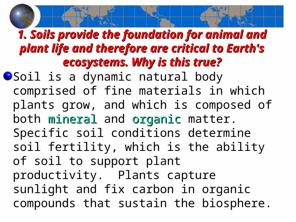
1. Soils provide the foundation for animal and plant life 1. Soils provide the foundation for animal and plant life and therefore are critical to Earth's ecosystems. Why is and therefore are critical to Earth's ecosystems. Why is
this true?this true?Soil is a dynamic natural body comprised of fine materials in which plants grow, and which is composed of both mineralmineral and organicorganic matter. Specific soil conditions determine soil fertility, which is the ability of soil to support plant productivity. Plants capture sunlight and fix carbon in organic compounds that sustain the biosphere.
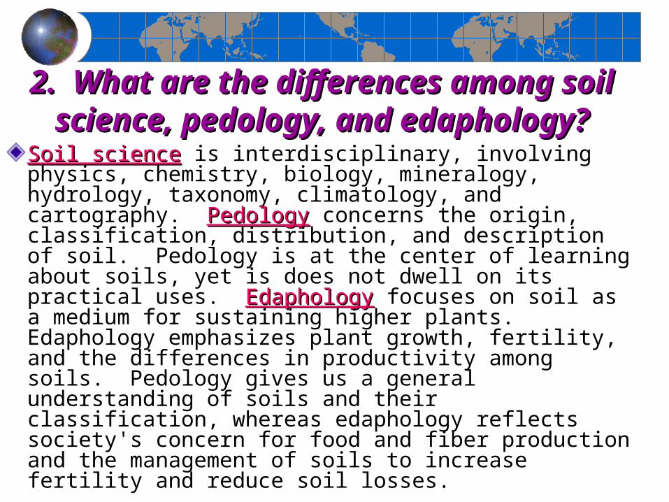
2. What are the differences among soil science, 2. What are the differences among soil science, pedology, and edaphology?pedology, and edaphology?
Soil scienceSoil science is interdisciplinary, involving physics, chemistry, biology, mineralogy, hydrology, taxonomy, climatology, and cartography. PedologyPedology concerns the origin, classification, distribution, and description of soil. Pedology is at the center of learning about soils, yet is does not dwell on its practical uses. EdaphologyEdaphology focuses on soil as a medium for sustaining higher plants. Edaphology emphasizes plant growth, fertility, and the differences in productivity among soils. Pedology gives us a general understanding of soils and their classification, whereas edaphology reflects society's concern for food and fiber production and the management of soils to increase fertility and reduce soil losses.
3. Define polypedon and pedon, the 3. Define polypedon and pedon, the basic units of soil.basic units of soil.
A soil profile selected for study should extend from the surface to the lowest extent of plant roots, or to the point where regolith or bedrock is encountered. Such a profile, known as a pedonpedon, is imagined as a hexagonal column encompassing from 1 m2 to 10 m2 in surface area (See next slide). At the sides of the pedon, the various layers of the soil profile are visible in cross section. A pedon is the basic sampling unit in soil surveys. Many pedons together in one area comprise a polypedonpolypedon, which has distinctive characteristics differentiating it from surrounding polypedons. These polypedons are the essential soil individuals, constituting an identifiable series of soils in an area. A polypedon has a minimum dimension of about 1 m2 and no specified maximum size. It is the soil unit used in preparing local soil maps.
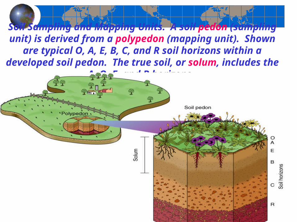
Soil Sampling and Mapping Units. A soil pedon (sampling unit) is derived from a polypedon (mapping unit). Shown are typical O, A,
E, B, C, and R soil horizons within a developed soil pedon. The true soil, or solum, includes the A, O, E, and B horizons.
4. Characterize the principal aspects of each soil horizon. 4. Characterize the principal aspects of each soil horizon. Where does the main accumulation of organic material Where does the main accumulation of organic material
occur? Where does humus form?occur? Where does humus form? EEach layer exposed in a pedon is a soil horizon. A horizonhorizon is roughly
parallel to the pedon's surface and has characteristics distinctly different from horizons directly above or below. The boundary between horizons usually is visible in the field, using the properties of color, texture, structure, consistence, porosity, the presence or absence of certain minerals, moisture, and chemical processes.
AAt the top of the soil profile is the O horizon, composed of organic material derived from plant and animal litter that was deposited on the surface and transformed into humus. HumusHumus is a mixture of decomposed organic materials in the soil and is usually dark in color. At the bottom of the soil profile is the R horizon, representing either unconsolidated material or consolidated bedrock of granite, sandstone, limestone, or other rock. The A, B, and C horizons mark differing mineral strata between O and R; these middle layers are composed of sand, silt, clay, and other weathered by-products. In the A horizon, the presence of humus and clay particles is particularly important, for they provide essential chemical links between soil nutrients and plants.
4a.Explain the difference between the eluviated 4a.Explain the difference between the eluviated layer and the illuviated layer. Which horizons layer and the illuviated layer. Which horizons
constitute the solum?constitute the solum?TThe lower portion of the A horizon grades into the E horizon, which is a bit more pale and is made up of coarse sand, silt, and resistant minerals. Clays and oxides of aluminum and iron are leached (removed) from the E horizon and migrate to lower horizons with water as it percolates through the soil. This process of rinsing through upper horizons and removing finer particles and minerals is termed eluviationeluviation; thus the designation E for this horizon. The greater the precipitation in an area, the higher the rate of eluviation that occurs in the E horizon. MMaterials are translocated to lower horizons by internal washing in the soil. In contrast to A horizons, B horizons demonstrate an accumulation of clays, aluminum, iron, and possibly humus. These horizons are dominated by illuviationilluviation—a depositional process. The C horizon is weathered bedrock or weathered parent material, excluding the bedrock itself. This zone is identified as regolith.TheThe combination of A horizon with its eluviation removals and the B horizon with its illuviation accumulations is designated the solumsolum, considered the true soil of the pedon.
6. Define a soil separate. What are the various 6. Define a soil separate. What are the various sizes of particles in soil? What is loam? Why is sizes of particles in soil? What is loam? Why is
loam regarded so highly by agriculturalists?loam regarded so highly by agriculturalists?Individual mineral particles are called soil separatessoil separates; those smaller than 2 mm in diameter (0.08 in.), such as very coarse sand, are considered part of the soil, whereas larger particles are identified as pebbles, gravels, or cobbles. Figure 18-4 shows a diagram of soil textures with sand, silt, and clay concentrations. The figure includes the common designation loamcommon designation loam (mixture), which is a mix of sand, silt, and clay in almost equal shares (ideal agricultural soil). A sandy loam with clay content below 30% is also excellent for farming because of its water-holding characteristics and ease of cultivation.
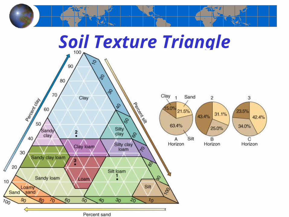
Soil Texture Triangle
7. What is a quick, hands-on method for 7. What is a quick, hands-on method for determining soil consistence?determining soil consistence?
MMethodology to determine the texture and structure of soil using your hands: Wet soils are variably sticky when held between the thumb and forefinger, ranging from a little adherence to either finger, to sticking to both fingers, to stretching when the fingers are moved apart. Plasticity, the quality of being molded, is roughly measured by rolling a piece of soil between your fingers and thumb to see whether it rolls into a thin strand. Moist soil implies that it is filled to about half of field capacity, and its consistence grades from loose (noncoherent), to friable (easily pulverized), to firm (not crushable between thumb and forefinger).
11. Briefly describe the contribution of the following 11. Briefly describe the contribution of the following factors and their effect on soil formation: climate, factors and their effect on soil formation: climate,
vegetation, landforms, and time.vegetation, landforms, and time.WWorldwide, soil types show a close correlation to climate types. The moisture, evaporation, and temperature regimes associated with varying climates determine the chemical reactions, organic activity, and eluviation rates of soils. Not only is the present climate important, but many soils also exhibit the imprint of past climates, sometimes over thousands of years.TThe organic content of soil is determined in part by the vegetation growing in that soil, as well as by animal and bacterial activity. The chemical makeup of vegetation contributes to acidity or alkalinity in the soil solution. For example, broadleaf trees tend to increase alkalinity, whereas needleleaf trees tend to produce higher acidity.LLandforms also affect soil formation, mainly through slope and orientation. Slopes that are too steep do not have full soil development, but slopes that are slight may inhibit soil drainage. As for orientation, in the Northern Hemisphere, a southern slope exposure is warmest (slope faces the southern Sun), which affects water balance relationships.
12. Explain some of the details that support 12. Explain some of the details that support concern over loss of our most fertile soils. What concern over loss of our most fertile soils. What cost estimates have been placed on soil erosion?cost estimates have been placed on soil erosion?Much effort and many dollars are expended to create fertile soil conditions, yet we live in an era when the future of Earth's most fertile soils is threatened. Soil erosion is created when soil holding vegetation is removed and the land is plowed regardless of topography (soil erodes by water). Soil erosion is increasing worldwide. Some 35% of farmland is losing soil faster than it can form–a loss exceeding 22.75 billion metric tons per year. Increases in production resulting from artificial fertilizers and new crop designs partially mask this effect, but such compensations for soil loss are nearing an end. Soil depletion and loss are at record levels from Iowa to China, Peru to Ethiopia, and the Middle East to the Americas. The impact on society could be significant. One 1995 study tabulated the market value of lost nutrients and other variables at over $25 billion a year in the United States and hundreds of billion dollars worldwide. The cost to bring soil erosion under control in the United States is estimated at approximately $8.5 billion, or about 30 cents on every dollar of damage and loss. (see next slide) (Movie: dust bowl).

Soil Degradation
Figure 18.8
13. How was slash-and-burn shifting cultivation, 13. How was slash-and-burn shifting cultivation, as practiced in the past, a form of crop and soil as practiced in the past, a form of crop and soil
rotation and conservation of soil properties?rotation and conservation of soil properties?Earlier slash-and-burn shifting cultivation practices were adapted to equatorial and tropical soil conditions and formed a unique style of crop rotation. The scenario went like this: people in the tropics cut down (slashed) and burned the rain forest in small tracts, cultivated the land with stick and hoe, and planted maize (corn), beans, and squash. After several years the soil lost fertility, and the people moved on to the next tract to repeat the process. After many years of movement from tract to tract, the group returned to the first patch to begin the cycle again. This practice protected the limited fertility of the soils somewhat, allowing periods of recovery to follow active production. However, the invasion of foreign plantation interests, development by local governments, vastly increased population pressures, and conversion of vast new tracts to pasturage halted this orderly native pattern of land rotation.
14. Describe the salinization process in arid 14. Describe the salinization process in arid and semiarid soils. What associated soil and semiarid soils. What associated soil
horizons develop?horizons develop?A soil process that occurs in Aridisols and nearby soil orders is salinization. Salinization results from poor water practices in semiarid agricultural regions of the world. Salts dissolved in soil water are brought to surface horizons and deposited there as surface water evaporates. Salinization damages and kills plants when salt deposits occur near the root zone. Vegetation grows best where soils are better drained and have lower salt content.
15. Which of the soil orders are 15. Which of the soil orders are associated with Earth's most productive associated with Earth's most productive
agricultural areas?agricultural areas?MollisolsMollisols (grassland soils) are some of Earth's most significant agricultural soils. There are seven recognized suborders, not all of which bear the same degree of fertility. The dominant diagnostic horizon is called the mollic epipedon, which is a dark, organic surface layer some 25 cm thick. As the Latin name implies, Mollisols are soft, even when dry, with granular or crumbly peds, loosely arranged when dry. (see next slide).
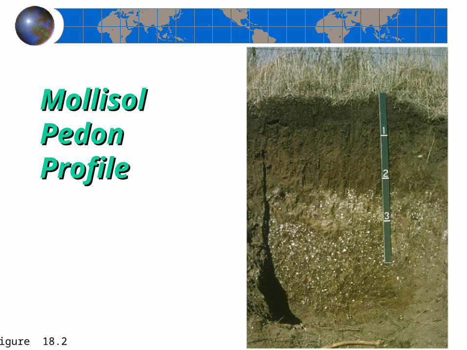
Mollisol Mollisol Pedon Pedon ProfileProfile
Figure 18.2
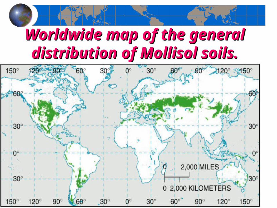
Worldwide map of the general Worldwide map of the general distribution of Mollisol soils.distribution of Mollisol soils.
Dust BowlDust BowlThe Dust Bowl of the 1930s lasted about a decade. Its primary The Dust Bowl of the 1930s lasted about a decade. Its primary area of impact was on the southern Plains (the prairie states of area of impact was on the southern Plains (the prairie states of Kansas, Texas, Oklahoma, and New Mexico). The drought, Kansas, Texas, Oklahoma, and New Mexico). The drought, windblown dust and agricultural devastation helped to lengthen windblown dust and agricultural devastation helped to lengthen the Great Depression whose effects were felt worldwide. the Great Depression whose effects were felt worldwide. Poor agricultural practices and years of sustained drought Poor agricultural practices and years of sustained drought caused the Dust Bowl. Plains grasslands had been deeply caused the Dust Bowl. Plains grasslands had been deeply plowed and planted to wheat. During the years when there was plowed and planted to wheat. During the years when there was adequate rainfall, the land produced bountiful crops. But as the adequate rainfall, the land produced bountiful crops. But as the droughts of the early 1930s deepened, the farmers kept plowing droughts of the early 1930s deepened, the farmers kept plowing and planting and nothing would grow. and planting and nothing would grow. The ground cover that The ground cover that held the soil in place was goneheld the soil in place was gone.. The Plains winds whipped The Plains winds whipped across the fields raising billowing clouds of dust to the skys. The across the fields raising billowing clouds of dust to the skys. The skys could darken for days, and even the most well sealed skys could darken for days, and even the most well sealed homes could have a thick layer of dust on furniture. In some homes could have a thick layer of dust on furniture. In some places the dust would drift like snow, covering farmsteads.places the dust would drift like snow, covering farmsteads.
Dust Bowl (continued)Dust Bowl (continued)When the drought and dust storms showed no signs of When the drought and dust storms showed no signs of letting up, many people abandoned their land. Others letting up, many people abandoned their land. Others would have stayed but were forced out when they lost would have stayed but were forced out when they lost their land in bank foreclosures. their land in bank foreclosures. The Dust Bowl exodus was the largest migration in The Dust Bowl exodus was the largest migration in American history. In all, one-quarter of the population American history. In all, one-quarter of the population left. By 1940, 2.5 million people had moved out of the left. By 1940, 2.5 million people had moved out of the Plains states.Plains states.Through later governmental intervention and methods Through later governmental intervention and methods of of erosion-prevention farmingerosion-prevention farming, the Dust Bowl , the Dust Bowl phenomenon has been virtually eliminated, thus left a phenomenon has been virtually eliminated, thus left a historic reference. historic reference.
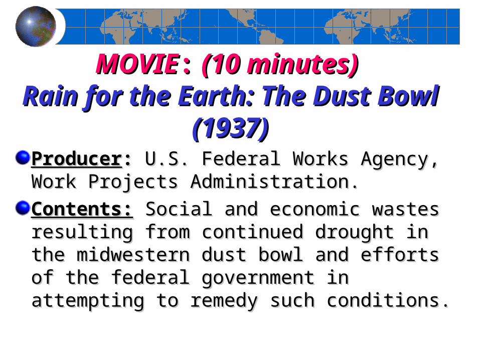
MOVIEMOVIE:: (10 minutes) (10 minutes) Rain for the Earth: The Dust Bowl Rain for the Earth: The Dust Bowl
(1937)(1937)ProducerProducer:: U.S. Federal Works Agency, Work U.S. Federal Works Agency, Work Projects Administration.Projects Administration.Contents:Contents: Social and economic wastes resulting Social and economic wastes resulting from continued drought in the midwestern dust from continued drought in the midwestern dust bowl and efforts of the federal government in bowl and efforts of the federal government in attempting to remedy such conditions.attempting to remedy such conditions.
End of Chapter 18
Geosystems 5eAn Introduction to Physical Geography
Robert W. ChristophersonCharlie Thomsen
Chapter 19Chapter 19
Ecosystem Ecosystem EssentialsEssentials
Geosystems 5eAn Introduction to Physical Geography
Robert W. ChristophersonCharlie Thomsen
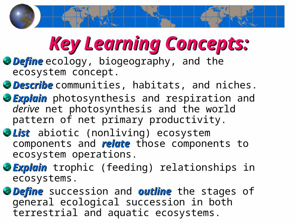
Key Learning Concepts:Key Learning Concepts:DefineDefine ecology, biogeography, and the ecosystem concept.DescribeDescribe communities, habitats, and niches.ExplainExplain photosynthesis and respiration and derive net photosynthesis and the world pattern of net primary productivity.ListList abiotic (nonliving) ecosystem components and relaterelate those components to ecosystem operations.ExplainExplain trophic (feeding) relationships in ecosystems.DefineDefine succession and outlineoutline the stages of general ecological succession in both terrestrial and aquatic ecosystems.
1. What is the relationship between the 1. What is the relationship between the biosphere and an ecosystem?biosphere and an ecosystem?
The interaction of the atmosphere, hydrosphere, and The interaction of the atmosphere, hydrosphere, and lithosphere produces conditions within which the lithosphere produces conditions within which the biosphere exists. This sphere of life and organic activity biosphere exists. This sphere of life and organic activity extends from the floor of the ocean to a height of about extends from the floor of the ocean to a height of about 8 km in the atmosphere. The biosphere is composed of 8 km in the atmosphere. The biosphere is composed of myriad ecosystems from simple to complex, each myriad ecosystems from simple to complex, each operating within general spatial boundaries. An operating within general spatial boundaries. An ecosystem is a self-regulating association of living plants ecosystem is a self-regulating association of living plants and animals and their nonliving physical environment. and animals and their nonliving physical environment. Earth itself is an ecosystem within the natural boundary Earth itself is an ecosystem within the natural boundary of the atmosphere. Various smaller ecosystems–for of the atmosphere. Various smaller ecosystems–for example, forests, seas, mountain tops, deserts, beaches, example, forests, seas, mountain tops, deserts, beaches, islands, lakes, ponds–make up the larger whole.islands, lakes, ponds–make up the larger whole.
4. Define a community within an 4. Define a community within an ecosystem.ecosystem.
A convenient biotic subdivision within an ecosystem is a communitycommunity, which is formed by interacting populations of living animals and plants in an area. An ecosystem is the interaction of a community with the abiotic (non biological) physical components of its environment. Many communities are included in an ecosystem. For example, in a forest ecosystem, a specific community may exist on the forest floor, whereas another functions in the canopy of leaves high above. Similarly, within a lake ecosystem, the plants and animals that flourish in the bottom sediments form one community, whereas those near the surface of the lake form another. A community is identified in several ways: by the physical appearance of the community, the number of species and the abundance of each, and the trophic (feeding) structure of the community.
5. What do the concepts of habitat 5. What do the concepts of habitat and niche involve?and niche involve?
Within a community, two concepts are important: habitat and niche. HabitatHabitat is the specific physical location of an organism, the place in which it resides or is biologically suited to live. In terms of physical and natural factors, most species have specific habitat parameters (with definite limits) and a specific regimen of sustaining nutrients. NicheNiche refers to the function, or occupation, of a life-form within a given community; it is the way an organism obtains and sustains its living. An individual species must satisfy several aspects in its niche; among these are a habitat niche, a trophic (food) niche, and a reproductive niche.
6. Describe symbiotic and parasitic 6. Describe symbiotic and parasitic relationships in nature.relationships in nature.
Some species have symbiotic relationships, or arrangements that mutually benefit and sustain each organism. For example, lichen (pronounced “liken”) is made up of algae and fungus. The algae are the producers and food source, and the fungus provides structure and support. Their mutually beneficial relationship allows the two to occupy a niche in which neither could survive alone. Lichen developed from an earlier parasitic relationship in which the fungi broke into algae cells directly. Today the two organisms have evolved into a supportive harmony.
7. How do plants function to link the 7. How do plants function to link the Sun's energy to living organisms?Sun's energy to living organisms?
The largest concentration of light-sensitive cells rests below the upper layers of the leaf. These are called chloroplast bodieschloroplast bodies, and within each resides a green, light-sensitive pigment called chlorophyllchlorophyll. Within this pigment, light stimulates photochemistry. Photosynthesis unites carbon dioxide and oxygen (derived from water in the plant) under the influence of certain wavelengths of visible light, subsequently releasing oxygen and producing energy-rich organic material.
88. What are the principal abiotic (non . What are the principal abiotic (non biological) components in terrestrial biological) components in terrestrial
ecosystems?ecosystems?TThe pattern of solar energy receipt is crucial in both terrestrial and aquatic ecosystems. Solar energy enters an ecosystem by way of photosynthesis, with heat dissipated from the system at many points. The duration of Sun exposure is the photoperiod. Air and soil temperatures determine the rates at which chemical reactions proceed. Operations of the hydrologic cycle and water availability depend on rates of precipitation/evaporation and their seasonal distribution. Water quality is important—its mineral content, salinity, and levels of pollution and toxicity.PPhotosynthetic rates are only slightly affected by temperature; a range of temperatures between 10°C to 35°C is optimum for plant productivity. However, photosynthesis is sharply reduced at high air and soil temperatures. As temperatures increase, photo-synthetic reaction rates increase accordingly, although leaf temperatures over 43°C are deadly to most plants.
9. Describe what Alexander von Humboldt found 9. Describe what Alexander von Humboldt found that led him to propose the life-zone concept. that led him to propose the life-zone concept.
What are life zones?What are life zones? Alexander von HumboldtAlexander von Humboldt (1769-1859) described a distinct relationship between altitude and plant communities- his life zone concept. As he climbed in the Andean mountains, he noticed that the experience was similar to that of traveling away from the equator toward higher latitudes. Each life zone possesses its own temperature, precipitation, and insolation relationships and therefore its own biotic communities. (See next slide).
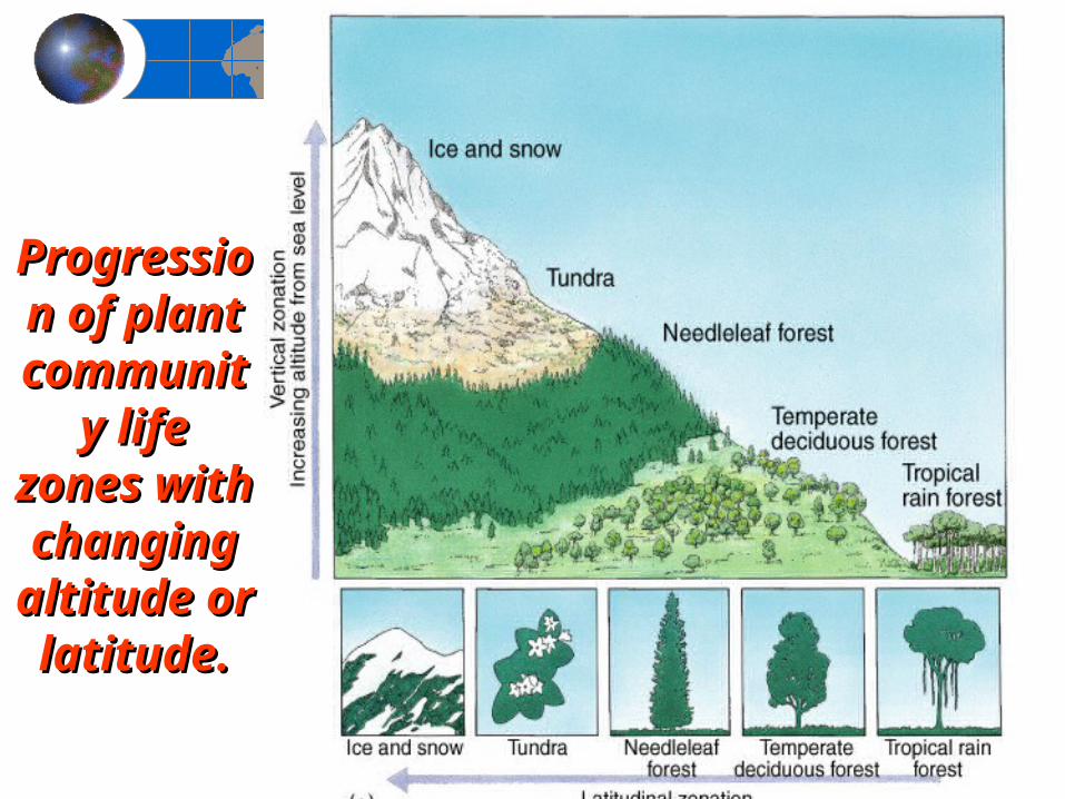
Progression Progression of plant of plant
community community life zones life zones
with with changing changing altitude or altitude or latitude.latitude.
10. What is a 10. What is a limiting factor?limiting factor? How does it function to How does it function to control the spatial distribution of plant and animal species?control the spatial distribution of plant and animal species?
The term limiting factorlimiting factor identifies the one physical or chemical component that most inhibits biotic operations, through its lack or excess. A few examples include: the low temperatures at high elevations, the lack of water in a desert, the excess water in a bog, the phosphorus content of soils in the eastern United States or at elevations above 6100 m where there is a general lack of active chlorophyll. In most ecosystems, precipitation is the limiting factor, although variation in temperatures and soil characteristics certainly affect vegetation patterns.
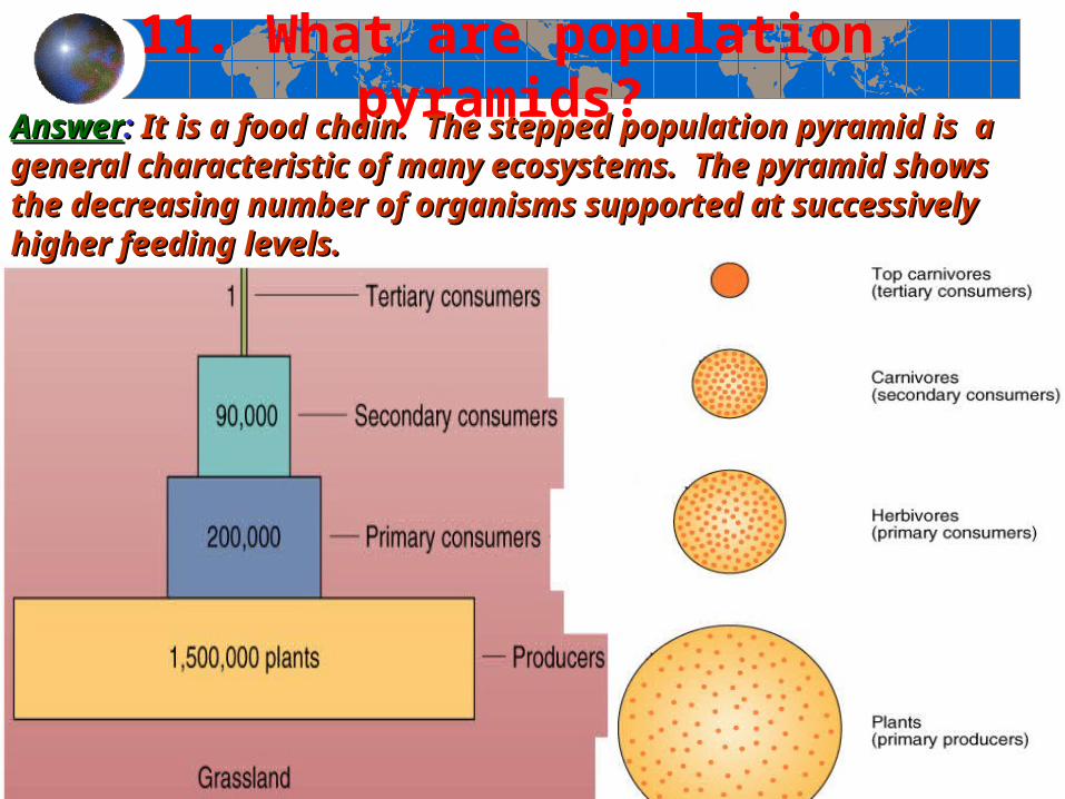
11. What are population pyramids? AnswerAnswer: : It is a food chain. The stepped population pyramid is a general It is a food chain. The stepped population pyramid is a general
characteristic of many ecosystems. The pyramid shows the decreasing characteristic of many ecosystems. The pyramid shows the decreasing number of organisms supported at successively higher feeding levels.number of organisms supported at successively higher feeding levels.
12. How does ecological succession proceed?12. How does ecological succession proceed? Each ecosystem is constantly adjusting to changing conditions and disturbances in the struggle to survive. The concept of change is key to understanding ecosystem stability. Ecological successionEcological succession occurs when different communities of plants and animals (usually more complex) replace older communities (usually simpler). Each temporary community of species modifies the physical environment in a manner suitable for the establishment of a later set of species. Changes were thought to move toward a more stable and mature condition, which is optimum for a specific environment.
13. Discuss the concept of fire ecology in the 13. Discuss the concept of fire ecology in the context of the Yellowstone National Park fires of context of the Yellowstone National Park fires of
1988.1988. Over the past 50 years, fire ecology has been the subject of much scientific research and experimentation. Today, fire is a natural component of most ecosystems and not the enemy of nature it once was popularly considered to be. In fact, in many forests, undergrowth is purposely burned in controlled "cool fires" to remove fuel that could enable a catastrophic and destructive “hot fire.” When fire suppression and prevention strategies are rigidly followed, they can lead to abundant undergrowth. Fire ecology imitates nature by recognizing fire as a dynamic ingredient in community succession.
14. What is the term 14. What is the term eutrophicationeutrophication means?means?
A lake experiences successional stages as it fills with nutrients and sediment and as aquatic plants take root and grow, capturing more sediment and adding organic debris to the system. This gradual enrichment through various stages in water bodies is known as eutrophicationeutrophication. The progressive stages in lake succession are named oligotrophicoligotrophic (low nutrients), mesotrophicmesotrophic (medium nutrients), and eutrophiceutrophic (high nutrients). Oliographic conditions occur in deep water, whereas eurothropic conditions occur along the shoreline. Each stage is marked by an increase in primary productivity and resultant decreases in water transparency so that photosynthesis becomes concentrated near the surface. Energy flow shifts from production to respiration in the eutrophic stage, with oxygen demand exceeding oxygen availability.
End of Chapter 19Ecosystem Essentials
Geosystems 5eAn Introduction to Physical Geography
Robert W. ChristophersonCharlie Thomsen